3D Virtual Itinerary for Education Using Google Earth as a Tool for the Recovery of the Geological Heritage of Natural Areas: Application in the “Las Batuecas Valley” Nature Park (Salamanca, Spain)

 ,
, 
Abstract
1. Introduction
2. Materials and Methods
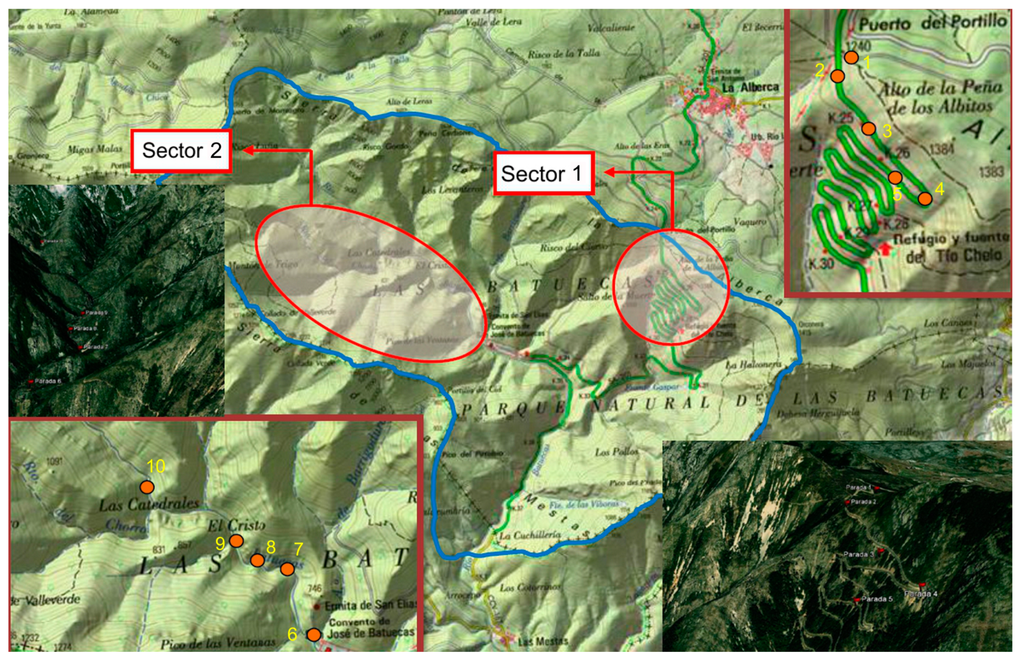
2.1. Situation and Analysis of Geological Context of the Itinerary


2.2. Inventory and Cataloguing of Geosites

| Parameters | Intrinsic value |
|---|---|
| Representativeness (quality of location to adequately illustrate the features of the domain) | |
| Useful as a model to partially represent a trait or process | 1 |
| Useful as a model to represent a trait or process | 2 |
| Best-known example and geological domain level considered to represent a trait or process | 4 |
| Character type locality or benchmark (quality of place as a stratigraphic, paleontological, and mineralogical reference) | Intrinsic value |
| Useful as a model to partially represent a trait or process | 1 |
| Useful as a model to represent a trait or process | 2 |
| Best-known example and geological domain level considered to represent a trait or process | 4 |
| Level of scientific knowledge of the location (geological relevance and scientific interest in publications and studies) | Intrinsic value |
| Published studies and/or doctoral thesis about the location | 1 |
| Focus of research by scientific teams and the subject of doctoral theses and published papers that have been referenced in national scientific journals | 2 |
| Focus of research by scientific teams and the subject of doctoral theses and published papers in international journals | 4 |
| State of conservation (existence of physical deterioration of the trait) | Intrinsic value |
| With impairments that prevent appreciation of some features of interest | 1 |
| Some defects, which do not decisively affect its value or interest | 2 |
| The geosite is well-preserved | 4 |
| Viewing conditions (offered by the environment to observe the trait). | Intrinsic value |
| Contain elements that do not enable appreciation of some features of interest for the geosite | 1 |
| Contain elements that do not enable complete observation of the geosite, despite the difficulty | 2 |
| Perfectly and easily observable in its entirety | 4 |
| Rarity (shortage of similar traits as described) | Intrinsic value |
| One of the few known examples at the regional level | 1 |
| Only example known at the regional level | 2 |
| Only example known at the national level (or international level) | 4 |
| Geological diversity (the existence of various types of geological interest in the same location) | Intrinsic value |
| The geosite has other interests in addition to the primary interest, which are not relevant | 1 |
| The geosite has two types of interests in addition to the primary interest, or only one relevant interest | 2 |
| The geosite has three or more types of interests in addition to the primary interest but only two interests are relevant | 4 |
| Educational content/educational use identified (trait is easily taught or already used for this purpose). | Intrinsic value and use |
| Illustrates university content of curricula | 1 |
| Illustrates curricula at all levels of the educational system | 2 |
| Commonly used in educational activities at all levels of the educational system | 4 |
| Logistics infrastructure (Existence of lodging and restaurants) | Use value |
| Accommodations for groups with 20 people within 25 km | 1 |
| Accommodations for groups with 40 people within 25 km | 2 |
| Accommodations for groups of 40 within 5 km | 4 |
| Population density (demand immediate potential) (Linked to the potential number of visits and the increased potential for vandalism) | Use value and protection |
| Less than 200,000 inhabitants within 50 km | 1 |
| Between 200,000 and 1,000,000 inhabitants within 50 km | 2 |
| More than 1,000,000 inhabitants within 50 km | 4 |
| Accessibility (Linked to easier access and a greater potential for vandalism) | Use value and protection |
| Direct access by dirt road but passable | 1 |
| Direct access by paved road with parking for cars | 2 |
| Direct access by paved road with parking for coach buses | 4 |
| Intrinsic fragility intrinsic vulnerability of the location due to its size or nature (deposits) | Use value and protection |
| Not vulnerable as visits but more sensitive to human activities and decametric aggressive traits | 1 |
| Hectometric features that may experience deterioration by human activities | 2 |
| Kilometric traits that are not damaged by human activities | 4 |
| Association with other nature/cultural elements. The site also does not contain other elements of geological interest. | Use value |
| Presence of a single element of natural or cultural heritage within 5 km | 1 |
| Presence of various elements of natural and cultural heritage within 5 km | 2 |
| Presence of various elements of natural and cultural heritage within 5 km | 4 |
| Visual beauty or spectacular trait or quality | Intrinsic value |
| Used only in the local tourist iconography | 1 |
| Used occasionally in the tourist iconography at the national or international level | 2 |
| Typically used in the tourist iconography at the national or international level | 4 |
| Informative content/use detected. The feature is easily identifiable or already used for this purpose | Intrinsic value and use |
| Demonstrates clear and expressive manner for groups of certain cultural levels | 1 |
| Demonstrates clear and expressive collective cultural level any way about the importance or usefulness of geology | 2 |
| Commonly used for outreach activities | 4 |
| Potential for tourism and recreational activities. The location satisfies the conditions for conducting activities or is already used for this purpose | Intrinsic value and use |
| You can make develop one of these activities | 1 |
| You can perform these activities | 2 |
| These activities are usually organized | 4 |
| Proximity to recreational areas (demand immediate potential) Linked to the potential number of visits and the increased potential for vandalism | Use value and protection |
| Geosite located within 5 km of a recreational area (campsites, popular beaches, national or natural parks, and visitor centers) | 1 |
| Geosite located within 2 km of a recreational area | 2 |
| Geosite situated within 500 meters of a recreational area | 4 |
| Socioeconomic environment. Socioeconomic conditions that favor its use as a factor of local development | Use value |
| Region with per capita income levels, education and occupation similar to the regional average but below the national average | 1 |
| Region with per capita income levels, education and occupation below the regional average | 2 |
| Site located in a region with socioeconomic decline | 4 |
| Parameter | Scientific interest | Educational interest | Tourist/recreational interest |
|---|---|---|---|
| Representativeness | 25 | 5 | --- |
| Character type locality | 20 | 5 | --- |
| Degree of scientific knowledge of the location | 15 | --- | --- |
| State of conservation | 10 | 5 | --- |
| Viewing conditions | 5 | 5 | 5 |
| Rarity | 15 | 5 | --- |
| Geological diversity | 10 | 10 | --- |
| Learning objectives/educational use | --- | 20 | --- |
| Logistics infrastructure | --- | 15 | 5 |
| Population density | --- | 5 | 5 |
| Accessibility | --- | 15 | 10 |
| Intrinsic fragility | --- | --- | 15 |
| Association with elements natural and/or cultural | --- | 5 | 5 |
| Beauty or spectacularity | --- | 5 | 20 |
| Informative content/use | --- | --- | 15 |
| Potential for tourism/recreation activities | --- | --- | 5 |
| Proximity to recreational areas | --- | --- | 5 |
| Socioeconomic environment | --- | --- | 10 |
| TOTAL | 100 | 100 | 100 |
| Parameters | Value |
|---|---|
| Anthropic vulnerability/existence of anthropogenic threats | |
| Location situated less than 100 meters from a road, less than 1 km from an industrial or mining area, less than 2 km from urban land in cities with less than 100,000 inhabitants or less than 5 km from older populations | 1 |
| Location adjacent to an industrial or mining area, adjacent to urban or undeveloped land, or located within 25 km of a road | 2 |
| Located in a mining area (active and abandoned), on the slope of a road or on urban land | 4 |
| Interest in mining/interesting in the mining of outcropping materials | |
| Substance is of minimal to moderate interest with farms in the area | 1 |
| Substance is of significant interest with farms in the area | 2 |
| Substance is of significant interest with no alternative holdings in the area | 4 |
| Natural vulnerability. Existence of natural hazards (active processes) | |
| Feature (s) vulnerable (s) to physical and chemical weathering | 1 |
| Location affected by active processes (erosion, flooding, and land movement) of moderate intensity | 2 |
| Location affected by intense active processes | 4 |
| Intrinsic fragility/intrinsic vulnerability due to its size or nature (deposits) | |
| Hectometric to kilometric traits that may experience deterioration by human activities | 1 |
| Decametric traits that are not vulnerable to visits but are sensitive to more aggressive human activities | 2 |
| Paleontological or mineralogical capability of plundering | 4 |
| Protection regime instead of possible protection depending on location within or outside a protected area | |
| Location with no form of protection but subject to management plan without care or cultural interest due to its paleontological/archaeological content | 1 |
| Location located in rural area with the preservation of land by its transformation through planning and urbanization of the town and country | 2 |
| Figure location that lacks any type of protection | 4 |
| Physical protection or indirect physical difficulties of access to the site | |
| Easily accessible and located far from paths and camouflaged by vegetation | 1 |
| Easily accessible and only camouflaged by vegetation | 2 |
| Location lacks any type of indirect protection | 4 |
| Accessibility (potential aggression) linked to the need for protection against vandalism | |
| Direct access by dirt road but passable | 1 |
| Direct access by paved road with parking for cars | 2 |
| Direct access by paved road with parking for coach buses | 4 |
| Ownership of the location: private, public repositories or restricted | |
| Geosite located in public areas and areas with restricted access | 1 |
| Geosite located on private property and areas with restricted access | 2 |
| Geosite located in public areas or private property repositories | 4 |
| Population density (potential aggression). Need for protection by increasing the likelihood of vandalism | |
| More than 100,000 inhabitants but less than 200,000 inhabitants within 50 km | 1 |
| Between 200,000 inhabitants and 1,000,000 inhabitants within 50 km | 2 |
| More than 1,000,000 inhabitants within 50 km | 4 |
| Proximity to recreational areas (potential aggression). Presence of recreational or tourist areas and linked to the increased possibility of vandalism | |
| Geosite located within 5 km of a recreational area (campsites and beaches) | 1 |
| Geosite located within 2 km of a recreational area | 2 |
| Geosite situated within 500 meters of a recreational area | 4 |
| Parameter | Weights |
|---|---|
| Anthropogenic threats | 15 |
| Interest in mining | 15 |
| Natural hazards | 15 |
| Intrinsic fragility | 10 |
| Protection regime | 10 |
| Physical or indirect protection | 10 |
| Accessibility | 10 |
| Ownership of the location | 5 |
| Population density | 5 |
| Proximity to recreational areas | 5 |
| TOTAL | 100 |
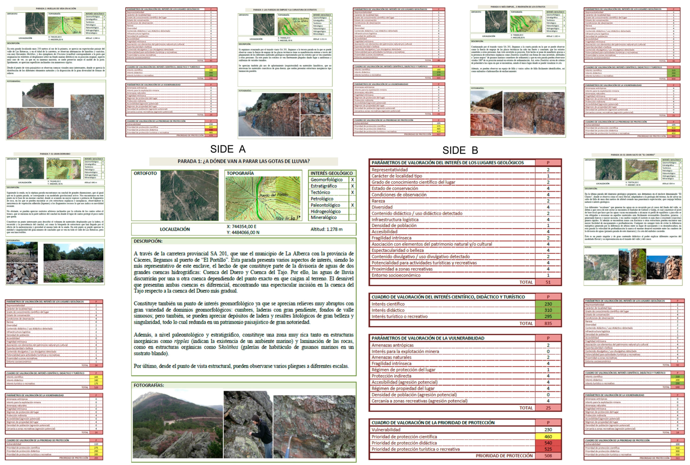
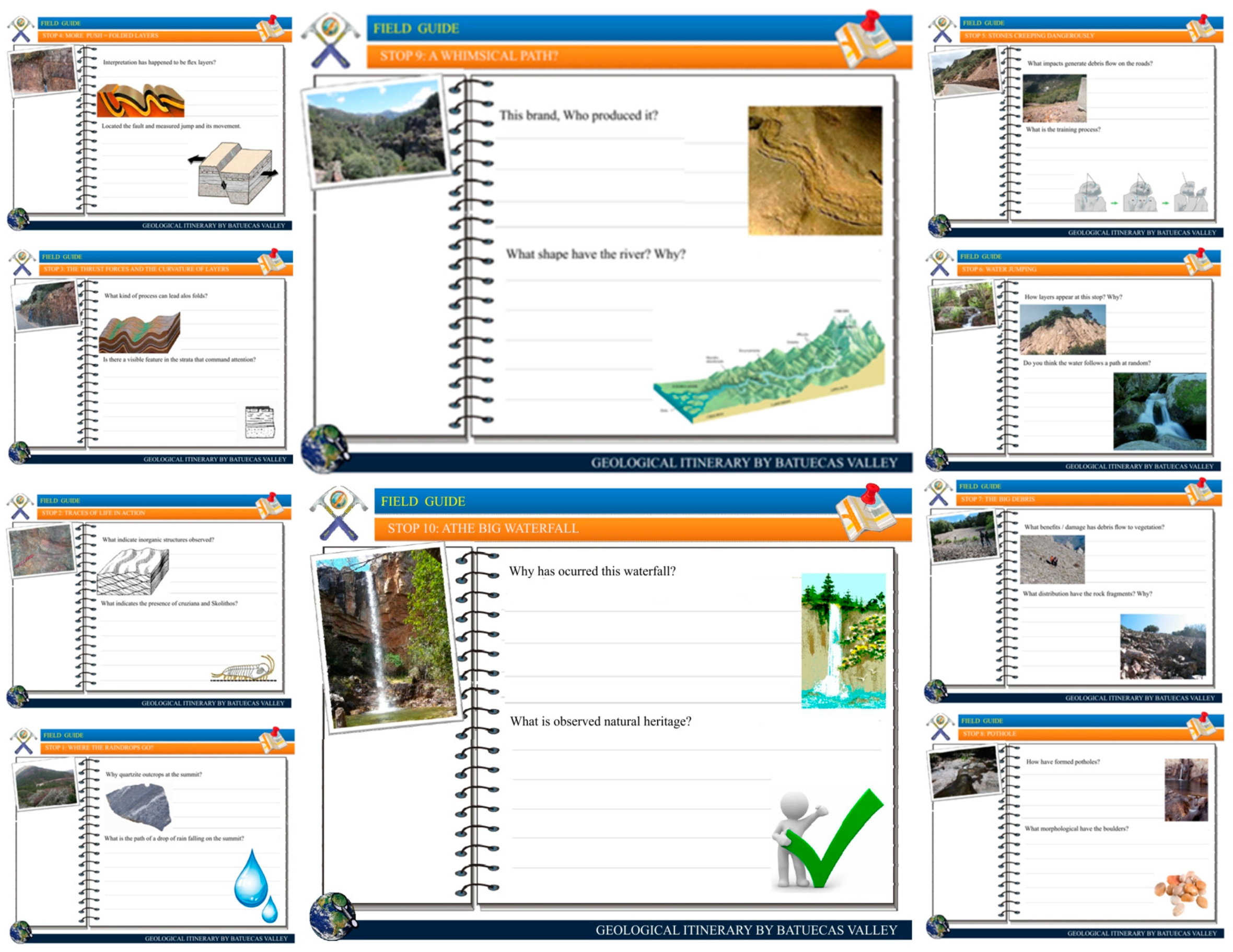
2.3. Educational Resources: Field Guide
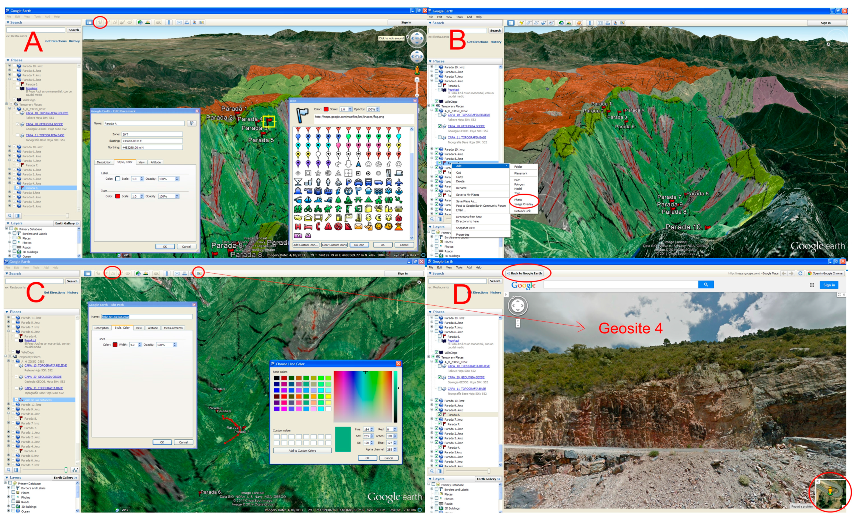
2.4. Preparation of Itinerary Using Google Earth and 3D Virtual Flight


3. Results and Discussion
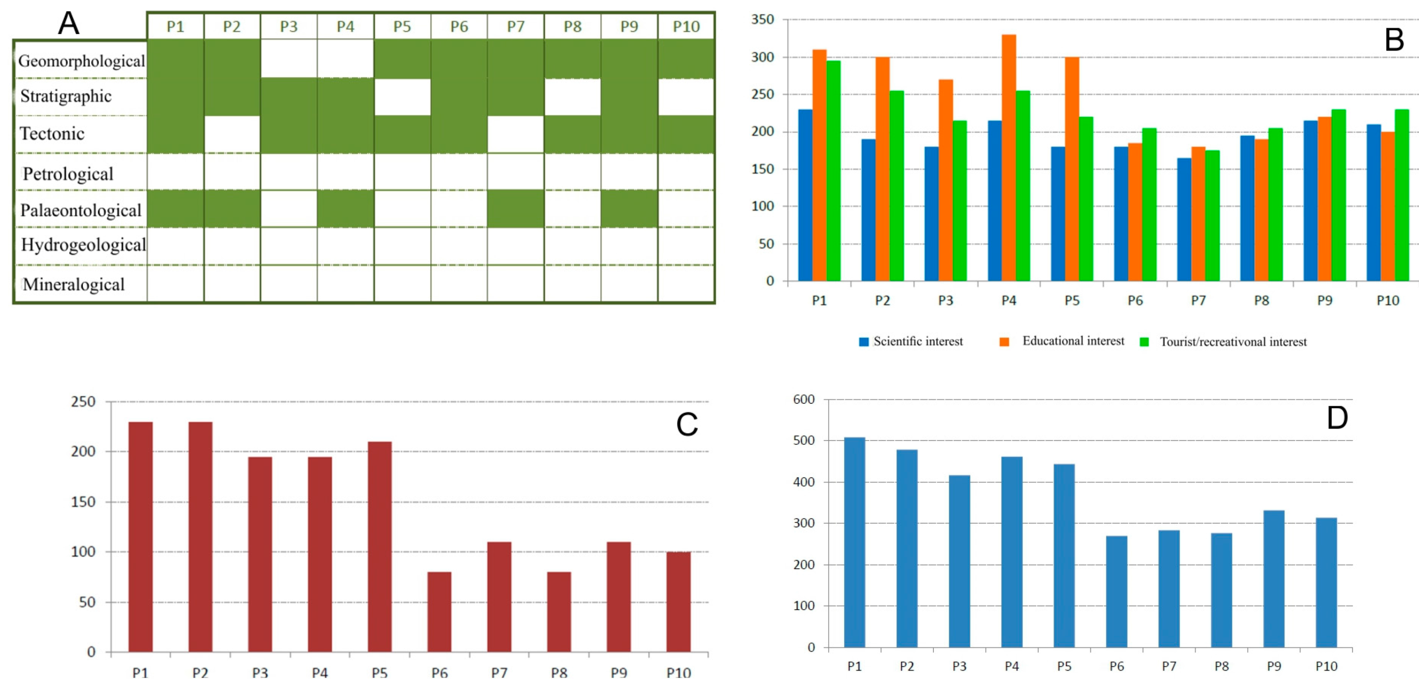
3.1. Inventory, Cataloguing and Assessment of the Stops on the Itinerary
| P1 | P2 | P3 | P4 | P5 | P6 | P7 | P8 | P9 | P10 | |||
|---|---|---|---|---|---|---|---|---|---|---|---|---|
| Parameters for assessment of geosites | ||||||||||||
| Representativeness | 2 | 2 | 2 | 2 | 2 | 2 | 2 | 2 | 2 | 2 | ||
| Character type locality | 1 | 1 | 1 | 1 | 1 | 1 | 1 | 1 | 1 | 1 | ||
| Degree of scientific knowledge about place | 2 | 2 | 1 | 1 | 1 | 1 | 1 | 1 | 1 | 2 | ||
| State of conservation | 4 | 2 | 4 | 4 | 4 | 4 | 4 | 4 | 4 | 4 | ||
| Viewing conditions | 4 | 4 | 4 | 4 | 4 | 4 | 4 | 4 | 4 | 4 | ||
| Rarity | 2 | 2 | 1 | 2 | 1 | 1 | 0 | 2 | 2 | 2 | ||
| Geological diversity | 4 | 2 | 2 | 4 | 2 | 2 | 2 | 2 | 4 | 2 | ||
| Learning objectives/educational use | 2 | 4 | 4 | 4 | 4 | 2 | 2 | 2 | 2 | 2 | ||
| Logistics infrastructure | 4 | 4 | 4 | 4 | 4 | 2 | 2 | 2 | 2 | 2 | ||
| Population density | 1 | 1 | 1 | 1 | 1 | 1 | 1 | 1 | 1 | 1 | ||
| Accessibility | 4 | 4 | 2 | 4 | 4 | 0 | 0 | 0 | 0 | 0 | ||
| Intrinsic fragility | 2 | 2 | 2 | 2 | 1 | 2 | 1 | 2 | 1 | 1 | ||
| Association with elements of nature/culture heritage | 4 | 2 | 2 | 2 | 2 | 4 | 4 | 4 | 4 | 4 | ||
| Beauty or spectacularity | 4 | 2 | 1 | 2 | 1 | 2 | 2 | 2 | 4 | 4 | ||
| Informative content/use | 2 | 4 | 4 | 4 | 4 | 2 | 2 | 2 | 2 | 2 | ||
| Potential for activities tourism/recreation | 4 | 0 | 0 | 0 | 0 | 4 | 1 | 4 | 4 | 4 | ||
| Proximity to recreational areas | 4 | 4 | 4 | 4 | 4 | 4 | 4 | 4 | 4 | 4 | ||
| Socioeconomic environment | 1 | 1 | 1 | 1 | 1 | 1 | 1 | 1 | 1 | 1 | ||
| Assessment of scientific, educational and tourist/recreational interest | ||||||||||||
| Scientific interest | 230 | 190 | 180 | 215 | 180 | 180 | 165 | 195 | 215 | 210 | ||
| Educational interest | 310 | 300 | 270 | 330 | 300 | 185 | 180 | 190 | 220 | 200 | ||
| Tourist/recreational interest | 295 | 255 | 215 | 255 | 220 | 205 | 175 | 205 | 230 | 230 | ||
| Total | 835 | 745 | 665 | 800 | 700 | 570 | 520 | 590 | 665 | 640 | ||
| Parameters for vulnerability of geosites | ||||||||||||
| Anthropogenic threats | 2 | 4 | 4 | 4 | 4 | 0 | 0 | 0 | 0 | 0 | ||
| Interest in mining | 0 | 0 | 0 | 0 | 0 | 0 | 0 | 0 | 0 | 0 | ||
| Natural hazards | 2 | 2 | 1 | 1 | 2 | 0 | 2 | 0 | 2 | 0 | ||
| Intrinsic fragility | 4 | 2 | 2 | 2 | 2 | 2 | 0 | 2 | 2 | 2 | ||
| Protection regime | 1 | 0 | 0 | 0 | 0 | 0 | 0 | 0 | 0 | 0 | ||
| Physical or indirect protection | 4 | 4 | 4 | 4 | 4 | 2 | 4 | 2 | 2 | 4 | ||
| Accessibility (*) | 4 | 4 | 2 | 2 | 2 | 0 | 0 | 0 | 0 | 0 | ||
| Ownership of the place | 4 | 4 | 4 | 4 | 4 | 4 | 4 | 4 | 4 | 4 | ||
| Population density (*) | 0 | 0 | 0 | 0 | 0 | 0 | 0 | 0 | 0 | 0 | ||
| Proximity to recreational areas (*) | 4 | 4 | 4 | 4 | 4 | 4 | 4 | 4 | 4 | 4 | ||
| Total | 25 | 24 | 21 | 21 | 22 | 12 | 14 | 12 | 14 | 14 | ||
| Assessment of vulnerability and protection priority | ||||||||||||
| Vulnerability | 230 | 230 | 195 | 195 | 210 | 80 | 110 | 80 | 110 | 100 | ||
| Scientific protection priority | 460 | 420 | 375 | 410 | 390 | 260 | 275 | 275 | 325 | 310 | ||
| Educational protection priority | 540 | 530 | 465 | 525 | 510 | 265 | 290 | 270 | 330 | 300 | ||
| Tourist/recreational protection priority | 525 | 485 | 410 | 450 | 430 | 285 | 285 | 285 | 340 | 330 | ||
| Protection priority | 508 | 478 | 417 | 462 | 443 | 170 | 283 | 277 | 332 | 313 | ||

3.2. Inventory, Cataloguing and Assessment of the Stops on the Itinerary
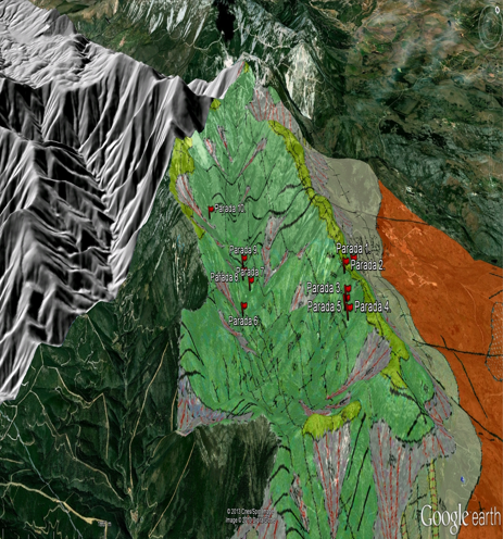
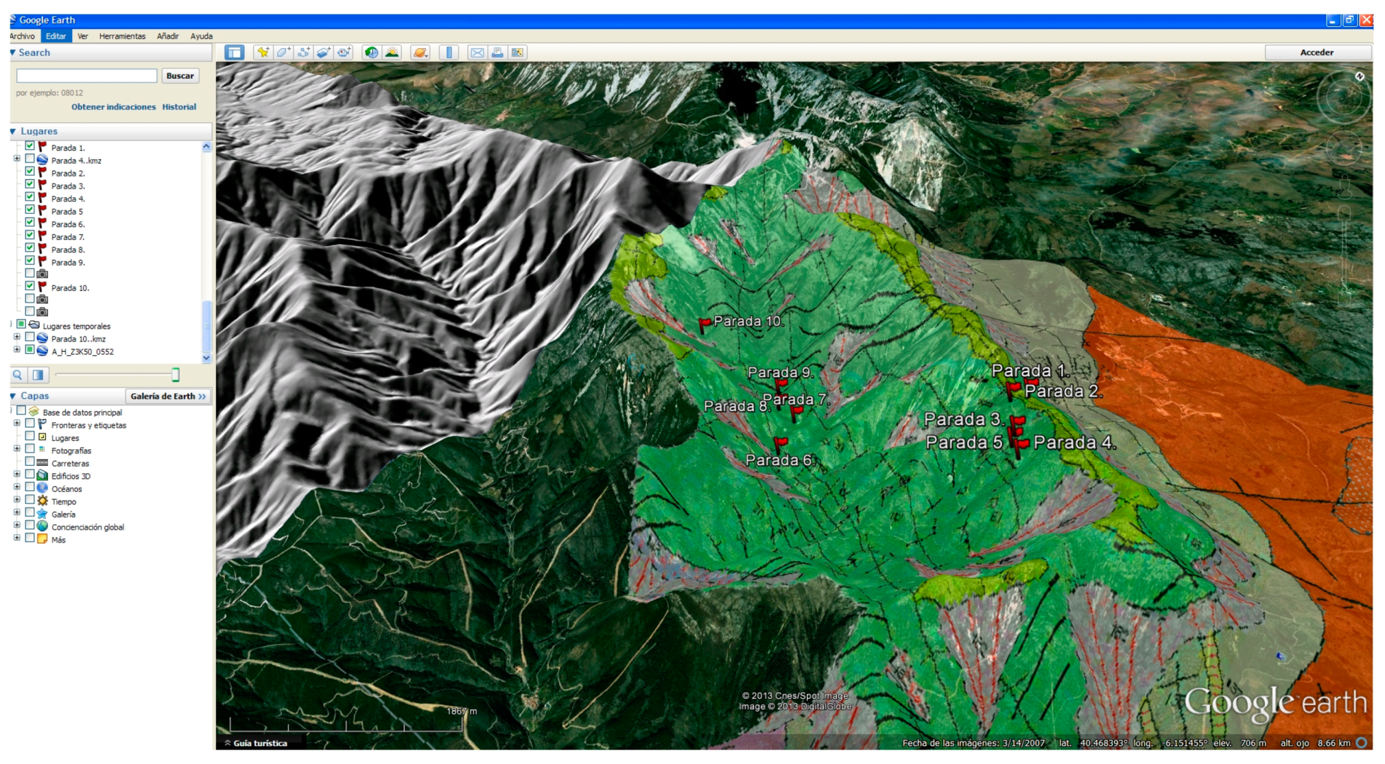
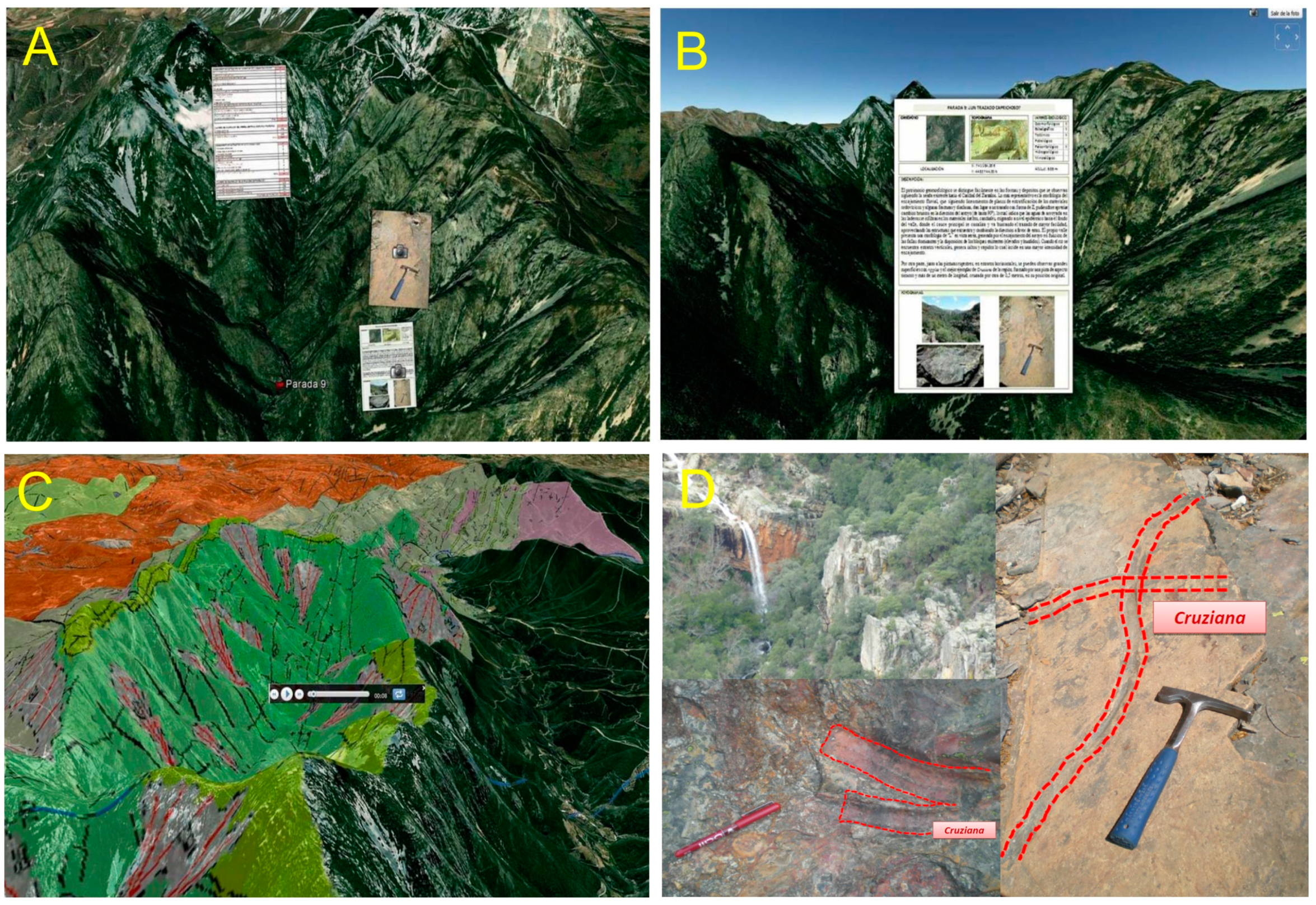
3.3. Itinerary and 3D Virtual Flight


4. Conclusions
Acknowledgments
Author Contributions
Conflicts of Interest
References
- Martínez-Graña, A.M.; Goy, J.L.G.Y.; Cardeña, Z.C. Natural Heritage Mapping of the Las Batuecas-Sierra De Francia and Quilamas Nature Parks (SW Salamanca, Spain). J. Maps 2011, 7, 600–613. [Google Scholar] [CrossRef]
- González-Delgado, J.A.; Martínez-Graña, A.M.; Civis, J.; Sierro, F.J.; Goy, J.L.; Dabrio, C.F.; Ruiz, F.; González-Regalado, M.L.; Abad, M. Virtual 3D tour of the Neogene palaeontological heritage of Huelva (Guadalquivir Basin, Spain). Environ. Earth Sci. 2014. [Google Scholar] [CrossRef]
- Gray, M. Geodiversity: Valuing and Conserving Abiotic Nature; Wiley: Hoboken, NJ, USA, 2004. [Google Scholar]
- Gallego, E.; García-Cortés, A. Patrimonio geológico y áreas naturales protegidas. Geogaceta 1996, 19, 202–206. (In Spanish) [Google Scholar]
- Boletin Oficial del Estado. (BOE). Ley 42/2007 del Patrimonio Natural y de la Biodiversidad. Boletin Oficial del Estado 2007, 299, 151275–51327. (In Spanish) [Google Scholar]
- Geoschools. Teaching Geosciences in secondary schools. Available online: http://geoschools.geol.uoa.gr/ (accessed on 4 January 2014).
- Goy, J.L.; González-Delgado, J.A.; López-Plaza, M.; Preto Gomes, E.; Zazo, C.; Cruz, R.; Martinez-Graña, A.M.; de Villota, I.; de Bustamante, I.; Civis, J.; et al. Arribes del Duero-Douro (Spain, Portugal): Posibilitéis for the First Iberian cross-border Geopark. In Processdings of Geoeventts, Geological Heritage, and the Role of the IGCP, Murcia, Spain, 5–18 September 2010.
- Henriques, M.H.; Tomaz, C.; Sá, A.A. The Arouca Geopark (Portugal) as an educational resource: A study case. Episodes 2012, 35, 481–488. [Google Scholar]
- Goy, J.L.; Martínez-Graña, A.M.; Sanz, J.; Cruz, R.; Andrés, C.; de Bustamante, I. Catalogación del patrimonio geológico de los Espacios naturales del Sur de Castilla y León (Salamanca-Ávila, España). Cuadernos del Museo Geominero 2013, 15, 389–400. (In Spanish) [Google Scholar]
- Cendrero, A. El patrimonio geológico. Ideas para su protección, conservación y utilización. In El Patrimonio Geológico. Bases Para su Valoración, Protección, Conservación y Utilización; Ministerio de Obras Públicas: Madrid, Spain, 1996; pp. 17–38. (In Spanish) [Google Scholar]
- García-Cortes, A.; Carcavilla, L. Documento metodológico para la elaboración del inventario español de lugares de interés geológico (IELIG). Available online: http://www.igme.es/patrimonio/novedades/METODOLOGIA%20IELIG%20web.pdf (accessed on 1 July 2014). (In Spanish)
- Bailey, J.E.; Chen, A. The role of virtual globes in geoscience. Comput. Geosci. 2011, 37, 1–2. [Google Scholar] [CrossRef]
- Schneps, M.H.; Ruel, J.; Sonnert, G.; Dussault, M.; Griffin, M.; Sadler, P.M. Conceptualizing astronomical scale: Virtual simulations on handheld tablet computers reverse misconceptions. Comput. Educ. 2014, 71, 269–280. [Google Scholar] [CrossRef]
- Tao, P.K. Conceptual change in science through collaborative learning at the computer. Int. J. Sci. Educ. 1999, 21, 39–57. [Google Scholar] [CrossRef]
- Martínez-Graña, A.M.; Goy, J.L.; Cimarra, C. A virtual tour of geological heritage: Valourising geodiversity using Google Earth and QR code. Comput. Geosci. 2013, 61, 83–93. [Google Scholar] [CrossRef]
- Couse, L.J.; Chen, D.W. A tablet computer for young children? Exploring its viability for early childhood education. J. Res. Technol. Educ. 2010, 43, 75–98. [Google Scholar]
- De Paor, D.; Whitmeyer, S.J. Geological and geophysical modelling on virtual globes using KML, Collada and Javascript. Comput. Geosci. 2011, 37, 100–110. [Google Scholar] [CrossRef]
- Blenkinsop, T.G. Visualizing structural geology: From Excell to Google Earth. Comput. Geosci. 2012, 45, 52–56. [Google Scholar] [CrossRef]
- Weng, Y.-H.; Sun, F.-S.; Grigsby, J.D. Geotools: An Android phone application in geology. Comput. Geosci. 2012, 44, 24–30. [Google Scholar] [CrossRef]
- Lim, C.P. Global citizenship education, school curriculum and games: Learning mathematics, English and science as a global citizen. Comput. Educ. 2008, 51, 1073–1093. [Google Scholar] [CrossRef]
- Esteban-Millat, I.; Martínez-López, F.J.; Huertas-García, R.; Meseguer, A.; Rodríguez-Ardura, I. Modelling students’ flow experiences in an online learning environment. Comput. Educ. 2014, 71, 111–123. [Google Scholar] [CrossRef]
- Kucirkova, N.; Messer, D.; Sheehy, K.; Fernández Panadero, C. Children’s engagement with educational iPad apps: Insights from a Spanish classroom. Comput. Educ. 2014, 71, 175–184. [Google Scholar] [CrossRef]
- Ibáñez, M.B.; Di Serio, Á; Villarán, D. Experimenting with electromagnetism using augmented reality: Impact on flow student experience and educational effectiveness. Comput. Educ. 2014, 71, 175–184. [Google Scholar]
- Díez Balda, M.A. El Complejo Esquisto-Grauvaquico, Las Series Paleozoicas y La Estructura Hercinica Al Sur de Salamanca; Universidad de Salamanca: Salamanca, Spain, 1986. (In Spanish) [Google Scholar]
- Zingaro, D.; Porter, L. Peer Instruction in computing: The value of instructor intervention. Comput. Educ. 2014, 71, 87–96. [Google Scholar] [CrossRef]
- Richard, M.O.; Chandra, R. A model of consumer web navigational behavior: Conceptual development and application. J. Bus. Res. 2005, 58, 1019–1029. [Google Scholar] [CrossRef]
- Kiili, K. Digital game-based learning: Towards an experiential gaming model. Internet High. Educ. 2005, 8, 13–24. [Google Scholar] [CrossRef]
- Papastergiou, M. Digital game-based learning in high school computer science education: Impact on educational effectiveness and student motivation. Comput. Educ. 2009, 52, 1–12. [Google Scholar] [CrossRef]
- Falloon, G. Young students using ipads: App design and content influences on their learning pathways. Comput. Educ. 2013, 68, 505–521. [Google Scholar] [CrossRef]
© 2014 by the authors; licensee MDPI, Basel, Switzerland. This article is an open access article distributed under the terms and conditions of the Creative Commons Attribution license (http://creativecommons.org/licenses/by/4.0/).
Share and Cite
Martínez-Graña, A.M.; González-Delgado, J.; Pallarés, S.; Goy, J.L.; Llovera, J.C. 3D Virtual Itinerary for Education Using Google Earth as a Tool for the Recovery of the Geological Heritage of Natural Areas: Application in the “Las Batuecas Valley” Nature Park (Salamanca, Spain). Sustainability 2014, 6, 8567-8591. https://doi.org/10.3390/su6128567
Martínez-Graña AM, González-Delgado J, Pallarés S, Goy JL, Llovera JC. 3D Virtual Itinerary for Education Using Google Earth as a Tool for the Recovery of the Geological Heritage of Natural Areas: Application in the “Las Batuecas Valley” Nature Park (Salamanca, Spain). Sustainability. 2014; 6(12):8567-8591. https://doi.org/10.3390/su6128567
Chicago/Turabian StyleMartínez-Graña, Antonio Miguel, José González-Delgado, Silvia Pallarés, José Luis Goy, and Jorge Civis Llovera. 2014. "3D Virtual Itinerary for Education Using Google Earth as a Tool for the Recovery of the Geological Heritage of Natural Areas: Application in the “Las Batuecas Valley” Nature Park (Salamanca, Spain)" Sustainability 6, no. 12: 8567-8591. https://doi.org/10.3390/su6128567
APA StyleMartínez-Graña, A. M., González-Delgado, J., Pallarés, S., Goy, J. L., & Llovera, J. C. (2014). 3D Virtual Itinerary for Education Using Google Earth as a Tool for the Recovery of the Geological Heritage of Natural Areas: Application in the “Las Batuecas Valley” Nature Park (Salamanca, Spain). Sustainability, 6(12), 8567-8591. https://doi.org/10.3390/su6128567