Scenario Simulation and the Prediction of Land Use and Land Cover Change in Beijing, China
Abstract
1. Introduction
2. Materials and Methods
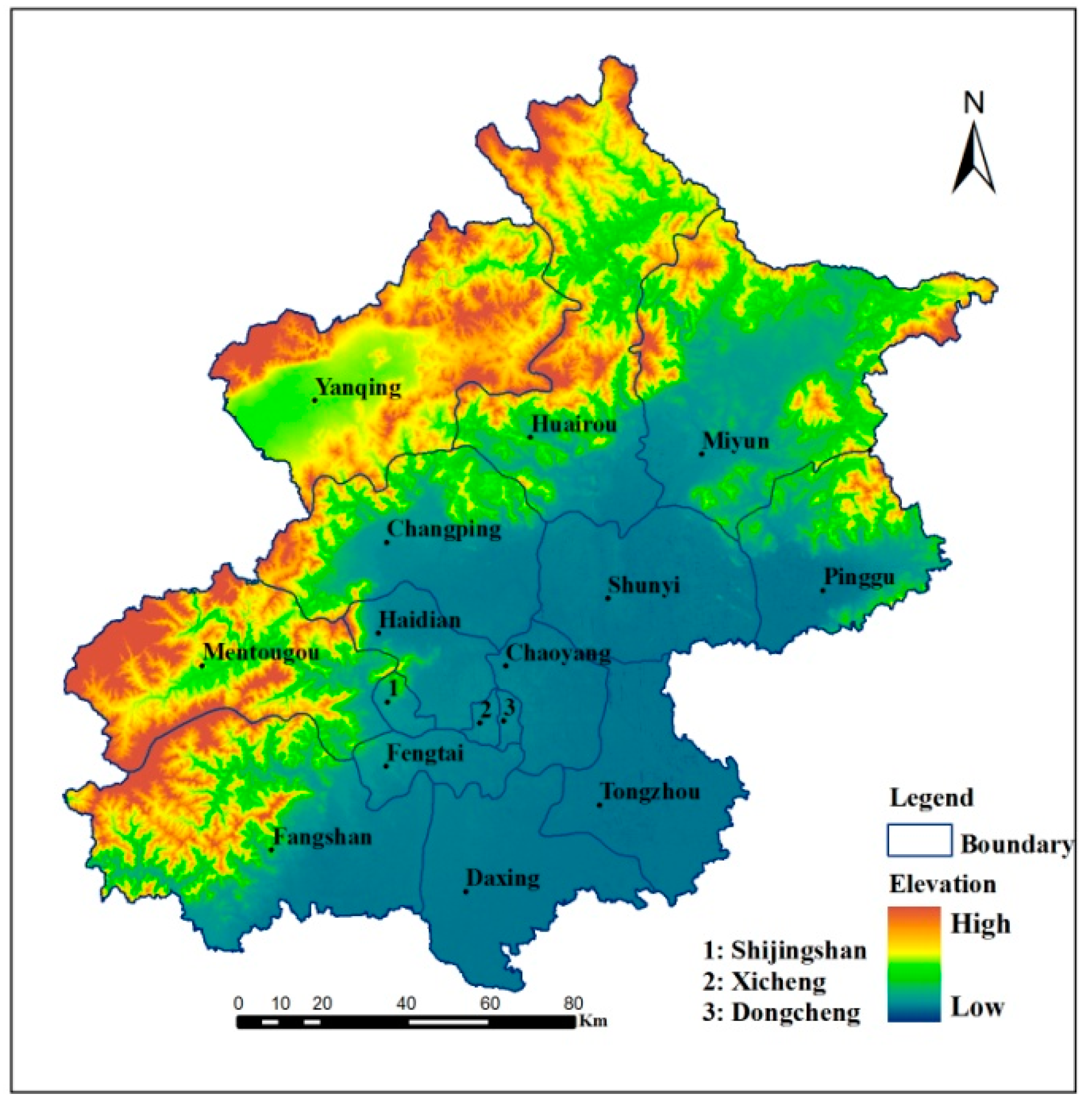
2.1. Study Area

2.2. Data
2.3. Methods
2.3.1. Land Use Dynamic Degree
2.3.2. Markov Model
2.3.3. CLUE-S Model
3. Results and Analysis
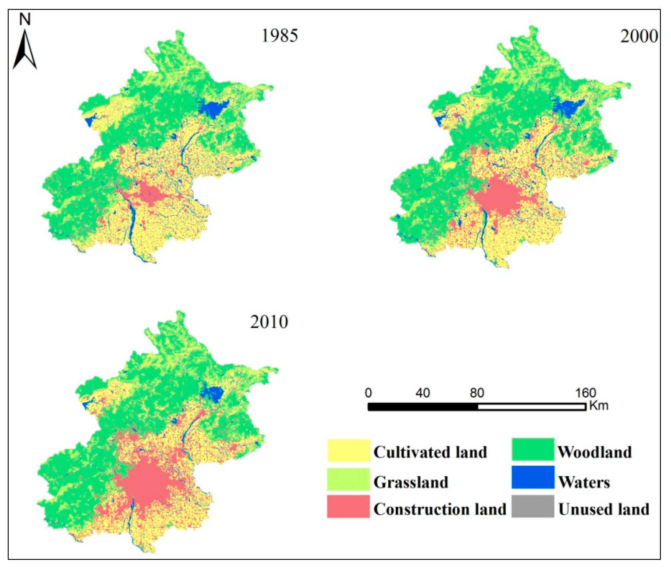
3.1. LULC Change Characteristics

3.2. Regression Analysis of the LULC Change Process

| Driving factors | Years | Cultivated land | Woodland | Grassland | Waters | Construction land | Unused land | ||||||
|---|---|---|---|---|---|---|---|---|---|---|---|---|---|
| β | Exp(β) | β | Exp(β) | β | Exp(β) | β | Exp(β) | β | Exp(β) | β | Exp(β) | ||
| Elevation | 2000 | −0.0011 | 0.9989 | 0.0004 | 1.0004 | 0.0011 | 1.0011 | ||||||
| 2010 | −0.0008 | 0.9992 | −0.0003 | 0.9997 | 0.0015 | 1.0015 | |||||||
| Slope | 2000 | −0.2270 | 0.7734 | 0.0331 | 1.0337 | −0.0264 | 0.9739 | −0.0220 | 0.9783 | −0.0581 | 0.9435 | ||
| 2010 | −0.1121 | 0.8980 | 0.0171 | 1.0173 | −0.0217 | 0.9785 | |||||||
| Distance to the river | 2000 | −0.0614 | 0.9404 | 0.0917 | 1.0960 | −0.0476 | 0.9535 | −0.1784 | 0.8366 | 0.0620 | 1.0640 | ||
| 2010 | −0.0606 | 0.9412 | 0.0954 | 1.1001 | −0.0430 | 0.9579 | −0.2470 | 0.7812 | 0.0260 | 1.0263 | |||
| Distance to the urban center | 2000 | 0.0234 | 1.0669 | 0.0185 | 1.0187 | 0.0519 | 1.0533 | −0.0838 | 0.9196 | 0.0609 | 1.0628 | ||
| 2010 | 0.0088 | 1.0212 | 0.0155 | 1.0156 | 0.0633 | 1.0654 | −0.0877 | 0.9160 | −0.0859 | 0.9177 | |||
| Distance to the local road | 2000 | 0.0351 | 1.0358 | −0.1481 | 0.8623 | ||||||||
| 2010 | 0.0505 | 1.0518 | 0.0296 | 1.0301 | 0.0464 | 1.0475 | −0.1658 | 0.8472 | |||||
| Distance to the railway | 2000 | 0.0504 | 1.0517 | −0.0630 | 0.9389 | −0.0410 | 0.9598 | 0.0367 | 1.0640 | −0.0423 | 0.9585 | ||
| 2010 | 0.0331 | 1.0336 | −0.0491 | 0.9521 | −0.0215 | 0.9787 | 0.0513 | 1.0603 | |||||
| Distance to the highway | 2000 | 0.0432 | 1.0577 | 0.0606 | 1.0625 | 0.0204 | 1.0206 | −0.0546 | 0.9468 | ||||
| 2010 | 0.0357 | 1.0349 | 0.0628 | 1.0648 | −0.0657 | 0.9364 | |||||||
| GDP | 2000 | −0.0225 | 0.9777 | −0.0185 | 0.9815 | 0.0322 | 1.0327 | ||||||
| 2010 | 0.0015 | 1.0015 | 0.0015 | 1.0015 | 0.0013 | 1.0013 | |||||||
| Urbanization | 2000 | −0.0274 | 0.9726 | −0.0985 | 0.9062 | −0.0807 | 0.9225 | −0.0173 | 0.9828 | 0.0362 | 1.0369 | ||
| 2010 | −0.0055 | 0.9943 | −0.0146 | 0.9855 | −0.0347 | 0.9659 | |||||||
| Population density | 2000 | 0.0006 | 1.0006 | 0.0002 | 1.0002 | −0.0002 | 0.9998 | ||||||
| 2010 | −0.0404 | 0.9584 | −0.0011 | 0.9989 | −0.0005 | 0.9995 | −0.0014 | 0.9986 | 0.0013 | 1.0013 | |||
| Constant | 2000 | −0.3677 | 0.6923 | 0.9723 | 2.6440 | −1.7567 | 0.1726 | −3.3856 | 0.0339 | −1.3041 | 0.2714 | −6.5598 | 0.0014 |
| 2010 | −0.0352 | 0.9654 | −0.8484 | 0.4281 | −3.1322 | 0.0436 | −4.3192 | 0.0133 | 0.2457 | 1.2785 | −4.8677 | 0.0077 | |
| ROC value | 2000 | 0.7730 | 0.8460 | 0.8100 | 0.7470 | 0.8250 | 0.7990 | ||||||
| 2010 | 0.7080 | 0.8300 | 0.7970 | 0.7980 | 0.8390 | 0.7320 | |||||||
3.3. Analysis of Transition Probability Matrix
| Cultivated land | Woodland | Grassland | Waters | Construction land | Unused land | |
|---|---|---|---|---|---|---|
| Cultivated land | 0.83 | 0.02 | 0.00 | 0.02 | 0.13 | 0.00 |
| Woodland | 0.00 | 0.99 | 0.00 | 0.01 | 0.00 | 0.00 |
| Grassland | 0.01 | 0.03 | 0.94 | 0.02 | 0.00 | 0.00 |
| Waters | 0.21 | 0.06 | 0.01 | 0.63 | 0.09 | 0.00 |
| Construction land | 0.00 | 0.00 | 0.00 | 0.01 | 0.99 | 0.00 |
| Unused land | 0.25 | 0.02 | 0.01 | 0.02 | 0.08 | 0.62 |
| Cultivated land | Woodland | Grassland | Waters | Construction land | Unused land | |
|---|---|---|---|---|---|---|
| Cultivated land | 0.78 | 0.03 | 0.00 | 0.01 | 0.17 | 0.01 |
| Woodland | 0.01 | 0.97 | 0.00 | 0.01 | 0.01 | 0.00 |
| Grassland | 0.02 | 0.04 | 0.92 | 0.00 | 0.02 | 0.00 |
| Waters | 0.17 | 0.05 | 0.04 | 0.58 | 0.15 | 0.01 |
| Construction land | 0.04 | 0.01 | 0.00 | 0.00 | 0.94 | 0.01 |
| Unused land | 0.04 | 0.61 | 0.14 | 0.00 | 0.05 | 0.16 |
3.4. Predicting LULC Change Based on the Markov Model
| Years | Scenario design | Cultivated land | Woodland | Grassland | Waters | Construction land | Unused land |
|---|---|---|---|---|---|---|---|
| 2010 | Actual land use | 406,692 | 741,789 | 119,772 | 44,082 | 311,013 | 10,305 |
| 2020 | Natural development | 333,279 | 756,891 | 115,083 | 21,330 | 400,014 | 7056 |
| Rapid development | 328,535 | 757,223 | 114,975 | 17,333 | 408,672 | 6916 | |
| Ecological-cultivated land protection | 360,912 | 751,635 | 116,718 | 34,890 | 364,575 | 4923 |
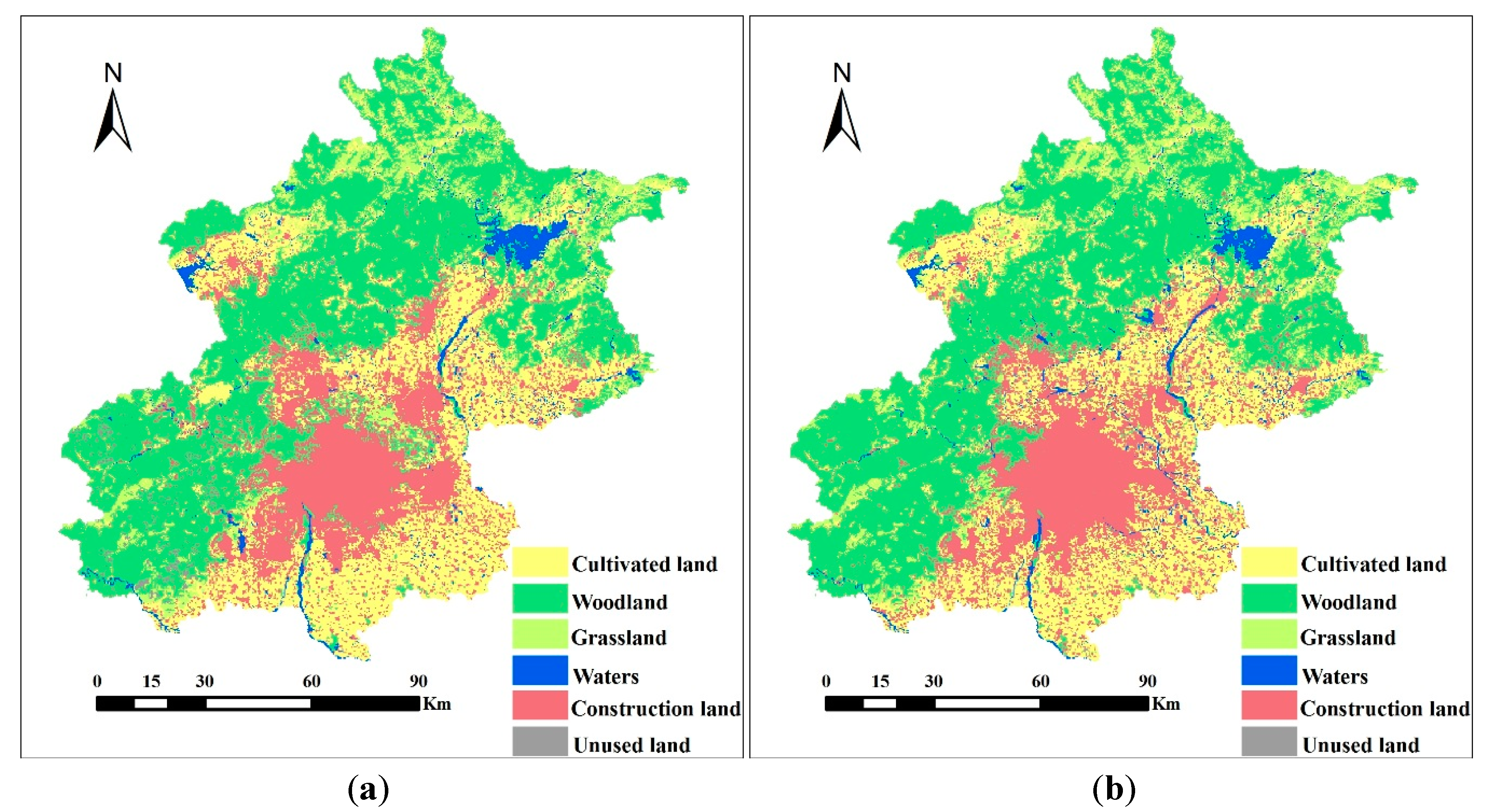
3.5. Model Validation

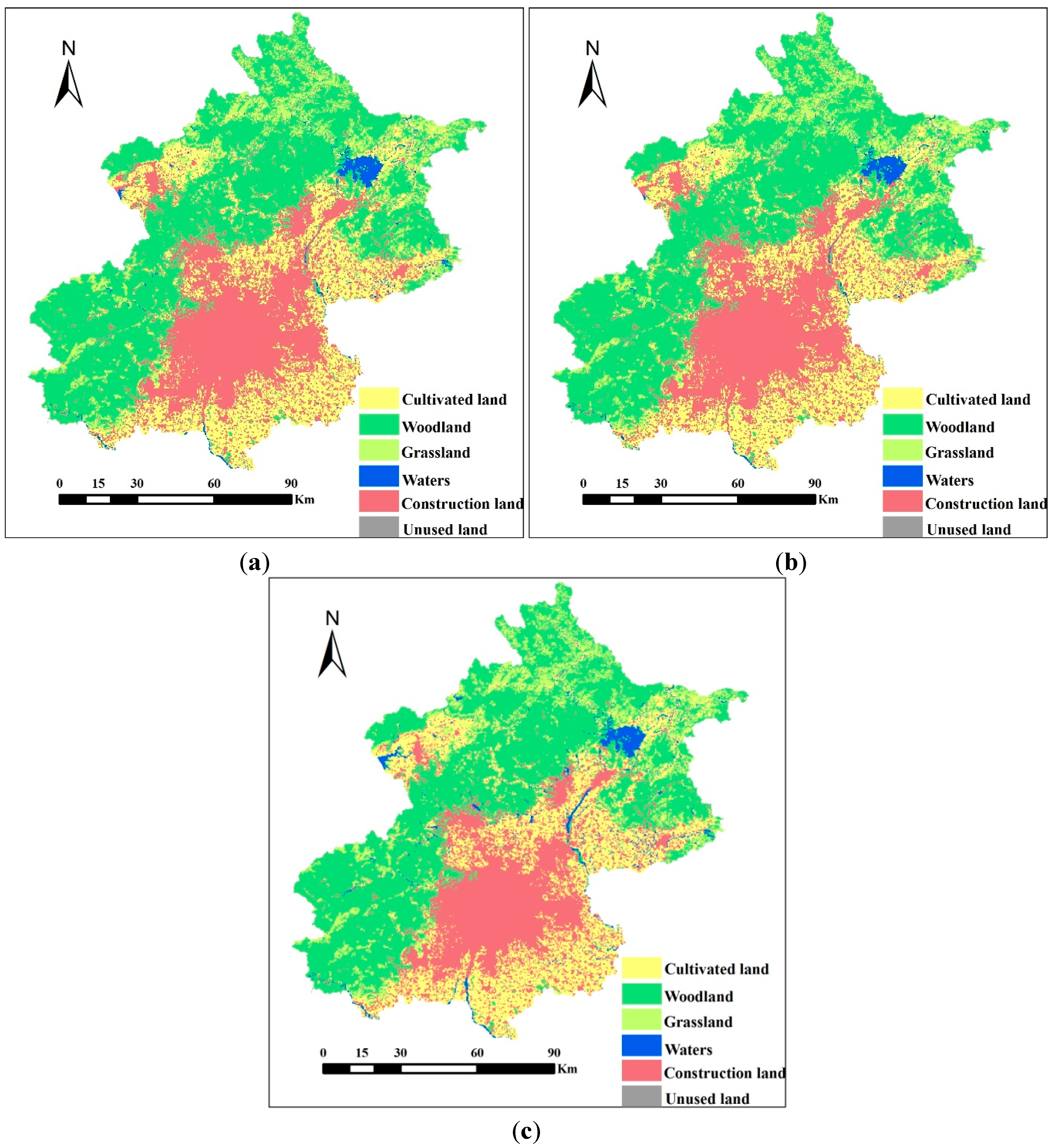
3.6. Analysis of Simulation Results

4. Discussion
5. Conclusions
Acknowledgments
Author Contributions
Conflicts of Interest
References
- Lambin, E.F.; Baulies, X.; Bockstael, N.; Fischer, G.; Krug, T.; Leemans, R.; Moran, E.F.; Rindfuss, R.R.; Skole, D.; Turner ll, B.L.; et al. Land-Use and Land-Cover Change: Implementation Strategy; IGBP Report No.48/IHDP Report No. 10; IGBP Secretariat: Stockholm, Sweden, 1999; pp. 125–126. [Google Scholar]
- Turner, B.L., II; Skole, D.L.; Sanderson, S.; Fischer, G.; Fresco, L.O.; Leemans, R. Land-Use and Land-Cover Change Science/Research Plan; IGBP Report No.35/HDP Report No.7; IGBP Secretariat: Stockholm, Sweden, 1995; pp. 132–133. [Google Scholar]
- Liu, J.Y.; Kuang, W.H.; Zhang, Z.X.; Xu, X.L.; Qin, Y.W.; Ning, J.; Zhou, W.C.; Zhang, S.W.; Li, R.D.; Yan, C.Z.; et al. Spatiotemporal characteristics, patterns, and causes of land-use changes in China since the late 1980s. Chin. Geogr. Sci. 2014, 24, 195–210. [Google Scholar] [CrossRef]
- Meyer, W.B.; Turner, B.L. Human population growth and global land-use/cover change. Annu. Rev. Ecol. Syst. 1992, 23, 39–61. [Google Scholar] [CrossRef]
- Dewan, A.M.; Yamaguchi, Y. Land use and land cover change in Greater Dhaka, Bangladesh: Using remote sensing to promote sustainable urbanization. Appl. Geogr. 2009, 29, 390–401. [Google Scholar] [CrossRef]
- Dewan, A.M.; Kabir, M.H.; Nahar, K.; Rahman, M.Z. Urbanization and environmental degradation in Dhaka metropolitan area of Bangladesh. Int. J. Environ. Sustain. Dev. 2012, 2, 118–147. [Google Scholar] [CrossRef]
- Byomkesh, T.; Nakagoshi, N.; Dewan, A.M. Urbanization and green space dynamics in Greater Dhaka, Bangladesh. Landsc. Ecol. Eng. 2012, 8, 45–58. [Google Scholar] [CrossRef]
- Corner, R.J.; Dewan, A.M.; Chakma, S. Monitoring and prediction of land-use and land-cover (LULC) change. In Proceedings of Dhaka Megacity—Geospatial Perspectives on Urbanization, Environment and Health: Chapter 5; Dewan, A.M., Corner, R.J., Eds.; Springer Geography: Berlin, Germany, 2014; pp. 75–97. [Google Scholar]
- Yin, Z.; Walcott, S.; Kaplan, B.; Cao, J.; Lin, W.; Chen, M.; Liu, D.; Ning, Y. An analysis of the relationship between spatial patterns of water quality and urban development in Shanghai China. Comput. Environ. Urban. 2005, 29, 197–221. [Google Scholar] [CrossRef]
- Zhao, S.; Da, L.; Tang, Z.; Fang, H.; Song, K.; Fang, J. Ecological consequences of rapid urban expansion: Shanghai, China. Front. Ecol. Environ. 2006, 4, 341–346. [Google Scholar] [CrossRef]
- Dewan, A.M.; Yamaguchi, Y. Effect of land cover changes on flooding: example from Greater Dhaka of Bangladesh. Int. J. Geoinf. 2008, 4, 11–20. [Google Scholar]
- Dewan, A.M.; Yamaguchi, Y.; Ziaur Rahman, M. Dynamics of land use/cover changes and the analysis of landscape fragmentation in Dhaka metropolitan, Bangladesh. Geojournal 2012, 77, 315–330. [Google Scholar] [CrossRef]
- Liu, W.D. Thinking of Economic Geography; Sciences Press: Beijing, China, 2013; pp. 164–165. [Google Scholar]
- Verburg, P.H.; Schot, P.P.; Dijst, M.J.; Veldkamp, A. Land use change modelling: Current practice and research priorities. Geojournal 2004, 61, 309–324. [Google Scholar] [CrossRef]
- Schaldach, R.; Alcamo, J.; Koch, J.; Kölking, C.; Lapola, D.M.; Schüngel, J.; Priess, J.A. An integrated approach to modeling land-use change on continental and global scales. Environ. Model. Softw. 2011, 26, 1041–1051. [Google Scholar] [CrossRef]
- Imbernon, J. Pattern and development of changes in the Kenyan highlands since the 1950s. Agr. Ecosyst. Environ. 1999, 176, 67–73. [Google Scholar] [CrossRef]
- Tian, Y.; Yin, K.; Lu, D.; Hua, L.; Zhao, Q.; Wen, M. Examining land use and land cover spatiotemporal change and driving forces in Beijing from 1978 to 2010. Remote Sens. 2014, 6, 10593–10611. [Google Scholar] [CrossRef]
- Kidron, G.J.; Karnieli, A.; Benenson, I.; Grinblat, Y. Simulating land-use degradation in West Africa with the ALADYN model. J. Arid. Environ. 2015, 112, 52–63. [Google Scholar] [CrossRef]
- Xu, Q.; Yang, K.; Wang, G.; Yang, Y. Agent-based modeling and simulations of land-use and land-cover change according to ant colony optimization: A case study of the Erhai Lake Basin, China. Nat. Hazards 2015, 75, 95–118. [Google Scholar] [CrossRef]
- Yi, Q.; Lam, N.S.N. Modeling land use and land cover changes in a vulnerable coastal region using artificial neural networks and cellular automata. Environ. Monit. Assess. 2015. [Google Scholar] [CrossRef]
- Badreldin, N.; Goossens, R. Monitoring land use/land cover change using multi-temporal Landsat satellite images in an arid environment: A case study of El-Arish, Egypt. Arab. J. Geosci. 2014, 7, 1671–1681. [Google Scholar] [CrossRef]
- Pei, B.; Pan, T. Land use system dynamic modeling: literature review and future research direction in China. Prog. Geogr. 2010, 29, 1060–1066. [Google Scholar]
- Arsanjani, J.J.; Helbich, M.; Kainz, W.; Boloorani, A.D. Integration of logistic regression, Markov chain and cellular automata models to simulate urban expansion. Int. J. Appl. Earth Obs. Geoinf. 2013, 21, 265–275. [Google Scholar] [CrossRef]
- Ahmed, B.; Ahmed, R. Modeling urban land cover growth dynamics using multi-temporal satellite images: A case study of Dhaka, Bangladesh. ISPRS. Int. J. Geoinf. 2012, 1, 3–31. [Google Scholar] [CrossRef]
- Vaz, E.; Walczynska, A.; Nijkamp, P. Regional challenges in tourist wetland systems: An integrated approach to the Ria Formosa in the Algarve, Portugal, 2013. Reg. Environ. Change 2013, 13, 33–42. [Google Scholar] [CrossRef]
- Parker, D.C.; Manson, S.M.; Janssen, M.A.; Hoffmann, M.J.; Deadman, P. Multi-agent systems for the simulation of land-use and land-cover change: A review. Ann. Assoc. Am. Geogr. 2003, 93, 314–337. [Google Scholar] [CrossRef]
- Veldkamp, A.; Verbug, P.H.; Kok, K.; de Koning, G.H.J.; Priess, J.; Bergsma, A.R. The need for scale sensitive approaches in spatially explicit land use change modeling. Environ. Model. Assess. 2001, 6, 111–121. [Google Scholar] [CrossRef]
- Al-shalabi, M.; Billa, L.; Pradhan, B.; Mansor, S.; Al-Sharif, A.A. Modelling urban growth evolution and land-use changes using GIS based cellular automata and SLEUTH models: The case of Sana’a metropolitan city, Yemen. Environ. Earth. Sci. 2013, 70, 425–437. [Google Scholar] [CrossRef]
- Verburg, P.H.; Eickhout, B.; Meijl, H.V. A multi-scale, multi-model approach for analyzing the future dynamics of European land use. Ann. Regional. Sci. 2008, 42, 57–77. [Google Scholar] [CrossRef]
- Hubacek, K.; Sun, L. A scenario analysis of China’s land use and land cover change: Incorporating biophysical information into input–output modeling. Struct. Econ. Dynam. 2001, 12, 367–397. [Google Scholar] [CrossRef]
- Verburg, P.H.; Soepboer, W.; Veldkamp, A.; Limpiada, R.; Espaldon, V.; Mastura, S.S. Modeling the spatial dynamics of regional land use: The CLUE-S model. Environ. Manag. 2002, 30, 391–405. [Google Scholar] [CrossRef]
- Wu, J.S.; Feng, Z.; Gao, Y.; Huang, X.; Liu, H.; Huang, L. Recent progresses on the application and improvement of the CLUE-S model. Prog. Geogr. 2012, 31, 3–10. [Google Scholar]
- Wu, Q.; Li, H.Q.; Wang, R.S.; Paulussen, J.; He, Y.; Wang, M.; Wang, Z. Monitoring and predicting land use change in Beijing using remote sensing and GIS. Landsc. Urban Plan. 2006, 78, 322–333. [Google Scholar] [CrossRef]
- Lu, R.C.; Huang, X.J.; Zuo, T.H.; Xiao, S.S.; Zhao, X.F.; Zhang, X.Y. Land Use Scenarios Simulation Based on CLUE-S and Markov Composite Model—A Case Study of Taihu Lake Rim in Jiangsu Province. Sci. Geol. Sinica 2009, 29, 577–581. [Google Scholar]
- Nourqolipour, R.; Shariff, A.R.B.M.; Balasundram, S.K.; Ahmad, N.B.; Sood, A.M.; Buyong, T.; Amiri, F. A GIS-based model to analyze the spatial and temporal development of oil palm land use in Kuala Langat district, Malaysia. Environ. Earth Sci. 2015, 73, 1687–1700. [Google Scholar] [CrossRef]
- Wang, X.L.; Bao, Y.H. Study on the methods of land use dynamic change research. Prog. Geogr. 1999, 18, 81–87. [Google Scholar]
- Hu, Y.; Zheng, Y.; Zheng, X. Simulation of land-use scenarios for Beijing using CLUE-S and Markov composite models. Chin. Geogr. Sci. 2013, 23, 92–100. [Google Scholar] [CrossRef]
- Pontius, R.G., Jr.; Schneider, L.C. Land-cover change model validation by an ROC method for the Ipswich watershed, Massachusetts, USA. Agr. Ecosyst. Environ. 2001, 85, 239–248. [Google Scholar] [CrossRef]
- Pontius, R.G., Jr; Cornell, J.D.; Hall, C.A. Modeling the spatial pattern of land-use change with GEOMOD2: Application and validation for Costa Rica. Agr. Ecosyst. Environ. 2001, 85, 191–203. [Google Scholar] [CrossRef]
- Pontius, R.G., Jr.; Malanson, J. Comparison of the structure and accuracy of two land change models. Int. J. Geogr. Inf. Sci. 2005, 19, 243–265. [Google Scholar] [CrossRef]
- Kamusoko, C.; Aniya, M.; Adi, B.; Manjoro, M. Rural sustainability under threat in Zimbabwe—Simulation of future land use/cover changes in the Bindura district based on the Markov-cellular automata model. Appl. Geogr. 2009, 29, 435–447. [Google Scholar] [CrossRef]
- Verburg, P.H.; Overmars, K.P. Dynamic simulation of land-use change trajectories with the CLUE-s model. Model. Land-Use Change 2007, 90, 321–337. [Google Scholar]
- Wan, L.; Jin, Y. Review on applied urban modeling and new trends of urban spatial policy models. Urban Plan. Forum. 2014, 1, 81–91. [Google Scholar]
- Barra, D.L.T. Integrated Land Use and Transport Modeling. Decision Chains and Hierarchies; Cambridge University Press: Cambridge, UK, 1989. [Google Scholar]
- Liu, L.; Long, Y.; Batty, M. A retrospect and prospect of urban models: Reflections after interviewing Mike Batty. City Plan. Rev. 2014, 38, 63–70. [Google Scholar]
- Wegener, M. The IRPUD model. Spiekermann & Wegener in Dortmund. Available online: http://www.spiekermann-wegener.com/mod/pdf/AP_1101_IRPUD_Model.pdf (accessed on 1 December 2011).
- Simmonds, D.C. The design of the delta land-use modeling package. Gen. Inf. 1999, 26, 665–684. [Google Scholar]
- Waddell, P. Urbansim: Modeling urban development for land use, transportation, and environmental planning. J. Am. Plann. Assoc. 2002, 68, 297–314. [Google Scholar] [CrossRef]
- Zondag, B.; De Bok, M.; Geurs, K.T.; Molenwijk, E. Accessibility modeling and evaluation: The TIGRIS XL land-use and transport interaction model for the Netherlands. Comput. Environ. Urban 2015, 49, 115–125. [Google Scholar] [CrossRef]
- Pontius, R.G., Jr.; Huffaker, D.; Denman, K. Useful techniques of validation for spatially explicit land-change models. Ecol. Model. 2004, 179, 445–461. [Google Scholar] [CrossRef]
- Brueckner, J.K.; Kim, H. Urban sprawl and the property tax. Int. Tax Public Finan. 2003, 10, 5–23. [Google Scholar] [CrossRef]
- Tsai, Y. Housing demand forces and land use towards urban compactness: A push-accessibility-pull analysis framework. Urban Stud. 2014, 6, 1–17. [Google Scholar]
- Castella, J.C.; Pheng Kam, S.; Dinh Quang, D.; Verburg, P.H.; Thai Hoanh, C. Combining top-down and bottom-up modelling approaches of land use/cover change to support public policies: Application to sustainable management of natural resources in northern Vietnam. Land. Use. Policy 2007, 24, 531–545. [Google Scholar] [CrossRef]
- De Bok, M.; Zondag, B.; Petersen, E. Modeling land use in the Generic Urban Model. In Proceedings of European Transport Conference (ETC), Strasbourg, France, 18–20 September 2006; pp. 15–28.
- Yigitcanlar, T.; Dur, F. Developing a sustainability assessment model: The sustainable infrastructure, land-use, environment and transport model. Sustainability 2010, 1, 321–340. [Google Scholar] [CrossRef]
© 2015 by the authors; licensee MDPI, Basel, Switzerland. This article is an open access article distributed under the terms and conditions of the Creative Commons Attribution license (http://creativecommons.org/licenses/by/4.0/).
Share and Cite
Han, H.; Yang, C.; Song, J. Scenario Simulation and the Prediction of Land Use and Land Cover Change in Beijing, China. Sustainability 2015, 7, 4260-4279. https://doi.org/10.3390/su7044260
Han H, Yang C, Song J. Scenario Simulation and the Prediction of Land Use and Land Cover Change in Beijing, China. Sustainability. 2015; 7(4):4260-4279. https://doi.org/10.3390/su7044260
Chicago/Turabian StyleHan, Huiran, Chengfeng Yang, and Jinping Song. 2015. "Scenario Simulation and the Prediction of Land Use and Land Cover Change in Beijing, China" Sustainability 7, no. 4: 4260-4279. https://doi.org/10.3390/su7044260
APA StyleHan, H., Yang, C., & Song, J. (2015). Scenario Simulation and the Prediction of Land Use and Land Cover Change in Beijing, China. Sustainability, 7(4), 4260-4279. https://doi.org/10.3390/su7044260