
Regionalist Principles to Reduce the Urban Heat Island Effect

Faculty of Architecture and the Built Environment, Delft University of Technology, Julianalaan 134, 2628 BL Delft, The Netherlands
*
Author to whom correspondence should be addressed.
Sustainability 2017, 9(5), 677; https://doi.org/10.3390/su9050677
Submission received: 27 December 2016
/
Revised: 13 April 2017
/
Accepted: 18 April 2017
/
Published: 25 April 2017
(This article belongs to the Section Sustainable Urban and Rural Development)
Abstract
:Scientists, climatologists, and urban planners have started to recognize the importance of nature at two very different scales: the global (metabolic) and the local (liveability) scales. The regional scale is the one at which these macro and micro approaches overlap. Future predictions foresee an increase of more than 2450 million urban inhabitants by 2050, thus new balanced urban visions need to be developed in order to guarantee the sustainability of urban areas. The Urban Heat Island (UHI) effect is a climate phenomenon resulting from unbalanced urban design arrangements. This paper analyses several design principles proposed by the 1920s regionalists from the UHI perspective. The preservation of the regional geographical landmarks, the implementation of urban containment policies (limiting city sizes), the increase of greenery and the development of green multifunctional blocks would help reduce the UHI in future urban developments.
1. Introduction
Scientists, climatologists, and urban planners have started to recognize the importance of the role of nature at two very different scales. On the one hand there is a metabolic approach to sustainability, which highlights the fact that nature is no longer the endless city supplier of resources (food, water, fuel, etc.) and its insatiable waste and emission disposal sink [1,2,3,4]. Already at the beginning of the 1970s, the Club of Rome aimed to examine “the complex of problems troubling men of all nations” and identified the degradation of the environment and the uncontrolled urban spread as two of the eight major problems affecting our societies worldwide, and carried out a study on nature’s limits in order to define the so called “state of global equilibrium” [1]. Also in the 1970s, several professionals formed multidisciplinary teams for the development of integrated and sustainable landscape designs [5]. Up to now, urban planners continue to highlight the indisputable role of nature in urban planning processes, emphasising the metabolic approach [2,3,4]. In our globalized and interconnected world, this metabolic approach analyses the role of nature at a planetary scale aiming at promoting more rational transportation and supply/consumption patterns. On the other hand, the role of nature at the city scale is also being examined: pollution, the effects of the urban heat island, and endless transportation journeys inside cities threaten to jeopardize the liveability of many modern cities. The answer to most of these issues, which considerably deplete the comfort of cities, is most often to create greener cities. More specifically, at the local level, green infrastructure plays a provisioning (such as food and water), supporting (habitat, nutrient, water cycling, etc.), regulating (climate, air quality, soil quality, etc.), and cultural (recreational, educational, etc.) role [6].
Agrarian societies relied on the large energy and material flows of the rural regions around the cities, creating a “concentric hinterland” around an urban nucleus [7], the natural environment background remaining “unaltered”. In turn, the evolution towards modern cities has altered that original regional balance. Even though the surface covered by cities does not actually occupy more than 3% of the earth [8,9], agricultural land use and settlements have already transformed more than three-quarters of the planet [10,11,12]. As pointed out by Ellis EC, these changes are due not only to the fact that the global population has quadrupled in the 20th century but also to the fact that per capita human consumption of food, energy, and resources has grown even faster [13]. Currently only one third of the global population has reached the state of well-being [14,15].
As highlighted by Hajer and Dassen [2], the increase of population—which will increase by 2.7 billion people in the next 50 years [16]—and the increase of urbanization—settlements and infrastructures are expected to expand by 260–420 million hectares by 2050 without policy interventions [17] and around half of these developments will occur on agricultural land [18]—will inevitably generate land related issues [19]. Thus, existing consumption patterns, population growth tendencies, urbanization dynamics, and production/consumption flows are undoubtedly unsustainable in the light of a changing climate. Politicians, urban planners, scientists, economists, corporations, and citizens need to urgently find ways of reverting this disastrous inertia. The United Nation’s 2030 Agenda for Sustainable Development addresses these issues with Goal 11: “Make cities and human settlements inclusive, safe, resilient and sustainable”, and Goal 13: “Take urgent action to combat climate change and its impacts” [20]. In parallel, the European Union aims to make the Union’s cities more sustainable, and help the Union address international environmental and climate challenges more effectively through its 7th Environment Action Programme. There are two main environmental consequences of the above mentioned global interdependency propensity: the first being the generation of anthropogenic heat emissions and the second being the generation of air pollution from carbon dioxide (automobile, industrial, and domestic combustions), particulates, and water vapour [21], which affect the radiation budget thus increasing the air temperatures [22]. This overall increase of global temperatures in turn intensifies the Urban Heat Island (UHI). The UHI is the temperature difference existing between the city (centre) and its immediate rural or natural surroundings Global and local climate change drivers do have an impact on the magnitude of UHI [23].
Cities are by definition areas for the concentration of human activity or in Lewis Mumford’s words, “a point of concentration for the power and culture of a community” [24]. This definition has not varied throughout the centuries. Despite the huge technological changes that have revolved around the nature of human relations in the last few decades, cities continue to be at the heart of economic, cultural, and social activity, and because of this they keep on growing and expanding [25]. Nowadays we can count several giant agglomerations such as Tokyo (more than 38 million inhabitants), Delhi (25 million), Shanghai (23 million), Mexico City (21 million), Mumbai (21 million), and Sao Paulo (21 million). By 2030 there will be more than 41 cities with more than 10 million inhabitants [8,9]. The urban population is supposed to increase dramatically in India where the increase of the urban population will exceed 400 million dwellers, in China where the increase will be of 292 million inhabitants, and in Nigeria with a predicted increase of 212 million people [26].
The UHI phenomenon is a clear particularity of the city climate. The UHI increased the impact of the European heat wave of 2003 that caused over 30,000 excess deaths across Europe, and it also increased the impact of the European heat wave of 2010 that caused 55,000 deaths in Russia alone [27]. Design and planning measures that can help reduce these impacts include: limiting the expansion of the city’s footprint, the introduction of greenery at the regional and local scale (street and roof level)—which also helps reduce the imperviousness, the introduction of high albedo materials (at the street and roof level), and the creation of cool wind corridors. Thus the introduction of greenery in city design is key.
It seems that the scale at which these two macro and micro sustainability approaches overlap is the regional one. Redefining the concept of regions is the first step to reaching a balance at the global and local level. At the global scale, promoting the creation of self-sufficient regions should reduce the interdependency among worldwide areas, thus reducing anthropogenic heat emissions, pollution, and therefore contributing to the reduction of global warming (which would in turn reduce the exacerbation of the UHI). At the local scale, reaching a regional balance would mean achieving a balance between compactness and sprawl, thus ensuring that cities are green enough to prevent them from overheating but still dense enough to ensure efficient transportation and infrastructural systems. Mumford L already developed in the first half of the 20th century the concept of regionalism to ensure a rational, balanced, and sustainable urban development [28]. This paper analyses how the regionalist principles suggested by Mumford L. can contribute to the reduction and mitigation of the urban heat island (UHI). It is the replication of sustainable and balanced regional patterns, which will guarantee global sustainability. More specifically, the reduction of the UHI effect will not only increase the comfort in cities and reduce the excess mortality, but will also reduce the energy consumption and even contribute to the reduction of global warming. Researchers reveal that the contribution of UHI to global warming might range from 2 to 4% [29].
Mumford highlighted the importance of the geographical factors (terrain, climate, and soil) which actually define regions [30]. Regionalism precisely revolves around three concepts: idea of restoring nature through the adaptation of new technologies (neotechnics), the principle of restoring the nature´s influence on culture through literature, architecture, and the built environment (organicism) and the concept of recovering the human-scaled, civic-minded social order through the community. Thus Mumford’s regionalism was not only rooted in environmental/scientific principles, but also had literary, political, and social implications [28,31]. The neotechnics and organicism premises strongly connect the natural and the built environment. The recovery of the harmony between these two worlds is actually the key for the reduction of the UHI effect and this is how the idea of analysing the implications of regionalism on UHI mitigation was born. The UHI phenomenon varies in time and is affected by the physical geography and by the built environment at the metropolitan region scale [32]. UHI varies depending on the physical properties of the surfaces, urban configuration, regional meteorology, and localized microclimate [22,33]. The first two parameters are related to the city itself, and the last two are specific to the region.
The aim of this investigation is to answer to the following research questions:
- -
- Do the regionalist principles developed by Geddes and Mumford still apply to the 21st century urbanization context?
- -
- If so, how would the implementation of these regionalist premises affect the UHI phenomenon?
2. Materials and Methods
This paper evaluates Mumford’s regionalist principles to test the validity of design and planning guidelines that help to define regional balance and equilibrium between compactness and sprawl in order to reduce UHI formation. With this purpose, first a qualitative analysis was completed, with overlapping and cross checking at three different scales (regional, urban, and neighbourhood) of the regionalist design principles with the UHI related literature, in order to be able to conclude whether the implementation of those regionalist design principles would play a positive or a negative role in the formation of UHI. The analysis of the regionalist principles was conducted through the revision of the original regional literature [28,30,31,34,35,36,37], as well as through the study of recent studies and reinterpretations of this urban theory [3,7,38].
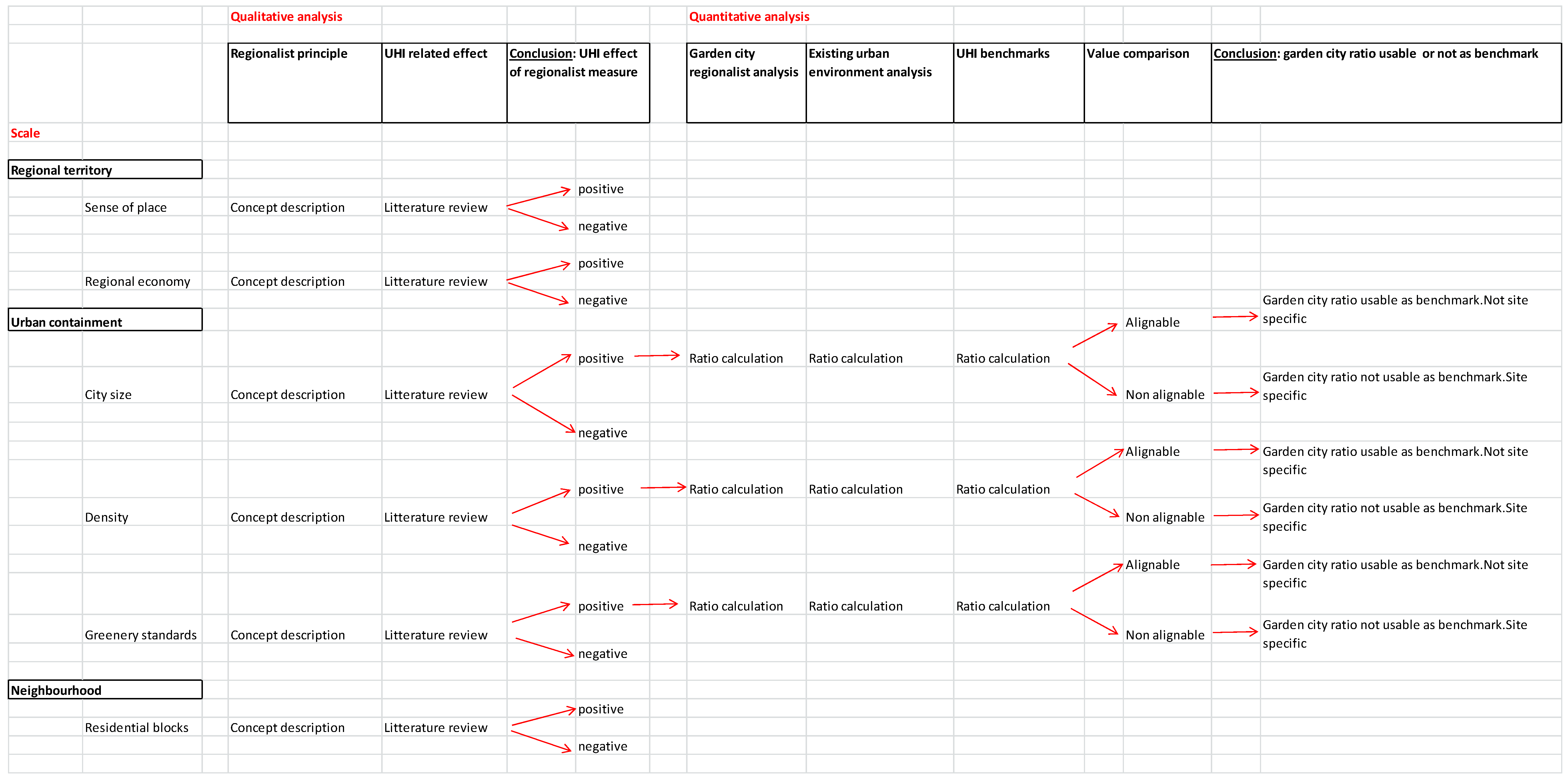
Furthermore, a quantitative analysis of the garden city models—which were presented by regionalists as the optimal urban planning forms to reach regional balance—was completed. The purpose of this quantitative analysis is to determine if the ratios and benchmarks put forward by the regionalists would still be implementable—with a positive effect on UHI formation—. A comparison was carried out between the city size, population density, and greenery standards of the regionalist city model (the garden city), existing urban ratios, and UHI principles. The comparative analysis of these ratios allows us to determine whether these are alignable or not, and thus whether the garden city model is still applicable or not (Figure 1), and to what extent.
3. Results
3.1. Regional Territory
3.1.1. Sense of Place/The Concept of Nature
As highlighted by Luccarelli, Mumford saw the basis of regionalism in the literary and artistic imagination rather than in a political idea. Mumford proposed the recovery, identification, and promotion of natural geographic features at the regional level—through scientific and imaginative exploration—in order to cultivate the so-called “sense of place” [28]. These regional geographic elements often represent natural regional cooling sources: mountains, forests, pastures, rivers, sea side, etc. The recommendation to enhance and preserve specific large-scale regional geographical elements is also often prescribed to mitigate the UHI effect. Climatologic plans typically foresee the creation of wind paths connecting these natural cooling sources to the urban hotspot areas.
It is the case of the Climate Analysis Map for the Stuttgart region in 2008 [39] which looks at maximizing the cooling capacity of the hilly forests surrounding the city, or the case of the climate maps of Arnhem in The Netherlands [40] which identify specific parks and forests outside the city as fresh air production zones to be preserved and or enhanced. In Tokyo the natural cooling source to be enhanced and preserved is the Tokyo Bay, and the renovation plans of the Tokyo Station vicinity aim at maximizing the cool wind paths connecting the cool bay breeze with the urban hotspots [41]. Finally, rivers often also act as the best wind paths to channel sea breeze into cities [42]. Vapour pressure and relative humidity on adjacent constructions vary depending on their orientation [43].
3.1.2. Regional Economy
Geddes and Mumford [3,7,28,38] highlighted that capitalism and globalization promoted the interdependency and specialisation of regions, ultimately increasing the destabilisation of the natural metabolism balance of regions. One of the pillars of their regionalism concept was the promotion of self-sufficient forms of metabolic structures. As expressed by Luccarelli, Mumford’s regionalist concept aimed at reaching a balance between human activities (including agriculture and industry) and regional realities, thus a balance between population and resources, vegetation, and animal life. The Congress for the New Urbanism also views metropolitan regions as fundamental economic units, and highlights the importance of the relationship and interconnection between the metropolis and its agrarian and natural landscapes [44]. In that sense The International Tripartite Conference on Urban Challenges and Poverty Reduction in African, Caribbean, and Pacific countries also expressed the potential of urban and peri-urban agriculture and forestry to improve the urban adaptation to climate change [45,46]. The idea supporting regionally self-sufficient agricultural production, thus promoting local and varied crops and avoiding agricultural over specialization, can be considered as a contemporary translation of Mumford’s regionalist concept.
Several UHI mitigation studies analyse the cooling capacity of agrarian fields. Irrigated agricultural fields can present air temperature differences of up to 3 °C with bare soil [15], and the overall surface temperature of crops is—in the case of the South Holland provincial parks—up to 5 °C less than the average surface temperature of built areas, however they are 2 °C higher than that of forests and up to 7 °C higher than that of large water surfaces during heat waves [47]. Hence, despite the fact that green and irrigated agricultural fields might have a cooling effect on the adjacent urban areas, they are not the coolest form of regional greenery. Thus the removal of forests for the increase of monocrop overspecialised agricultural land reduces the natural cooling capacity of the regions.
Further, crop cycles imply that at certain periods of the year, cropland is either not green, or not irrigated, reducing its potential cooling capacity, depending on the crop species. Thus, the reduction of regional agricultural specialisation (suggested by Mumford in his regionalism proposal), would on the one hand allow us to maintain other native land use cover present at a regional scale (such as forests or water surfaces), and on the other hand would promote the presence of different crop typologies, with potentially different crop cycles, which would in principle reduce the surface affected during greenless periods.
3.2. Urban Containment
Geddes warned against the sprawl of British and North American cities, and referred to those as “conurbations” [34] anticipating what we could call the dilemma of modern urbanism. On the one hand, human concentration is not only desirable—to ensure activity (or positive collision) and exchange—but is also even critical to ensure the efficiency and sustainability of those exchanges. At an infrastructural scale, MacKaye—one of the fathers of regionalism—was extremely concerned by the planning of highway networks and their corresponding uncontrolled commercial strip developments, which precede residential and industrial sprawl, and in turn proposed the limitation of accesses to highways in order to create “townless highways” [48].
Since Geddes, MacKay and Mumford, urban planners, climatologists, and ecologists have preached against urban sprawl. Countries like France, Switzerland, England, and the Netherlands introduced borderlines in planning documents in order to preserve ecological conservation zones and to protect agricultural land, while stimulating new urban developments in areas served by public transport corridors and hubs. On the other hand, this “aimed” compactness or high density seemed to have its limits, since the largest cities would benefit from the creation of new green infrastructure, meaning that a certain reduction of density is thus also desirable (Figure 2).
3.2.1. City Sizes and Population Densities for Regionally Balanced Environments
The regionalists already suggested the idea of urbanization containment. MacKaye compared suburbanization to the backflow of a water system and highlighted the importance of limiting growth (in his own words, the population flow) and referred to the need to definite boundaries [35]. Limiting growth is also a part of the UHI mitigation strategy. Several studies relate the maximum UHI to the logarithm of the population of the analysed city, not only for European cities [49,50], but also for North American [49,51,52], Japanese [53,54,55,56], and South Korean [57] cities. Containing city growth was a concern not only for the last century’s regionalists but also for UHI researchers.
In order to avoid city growth, the regionalists suggested the creation of autonomous garden cities in the countryside [58]. MacKaye and Mumford used the garden cities as examples. The model used was the one developed by Howard E but they also referred to built cases such as Letchworth and Welwyn in England and Radburn in New Jersery, United States, and identified the uncontrolled metropolitan growth of New York or Blanktown as examples to avoid [35]. Mumford proposed the garden city models, such as Sunnyside—from Henry Wright—as examples for the use of new technologies of that time (hydro-generated electric power and automobiles) to revert the harm done by the industrial cities to the environment [36,37].
The garden city models used as examples of regionally balanced urban environments can be assimilated to the “sparsely built” and to the “open low rise” local climate zones developed for the city of Vancouver [58]. In this study, 17 different local climate zones are defined, each with specific arrangements of built structures, surface cover, and human activity, which makes them present different UHI behaviours. In Vancouver, during calm clear evenings in the month of March 2010, the “sparsely built” and “open low rise” typologies presented lower temperatures than the “compact high rise”, “open high rise”, and “large low rise” typologies. Thus a reduction of the percentage of impervious surfaces, an increase of the surface greenery, and a reduction of the built mass which actually characterize the garden city urban design proposals, would contribute to the reduction of the formation of UHI. The surface cover analysis of sixteen cities in the region of North Brabant in The Netherlands also reveals that the small urban centres present better thermal behaviour than the larger urban city centres (with more impervious areas and lower Normalized Difference Vegetation Index–NDVI–), the majority of the analysed cities had surfaces below 20 km2 and populations also below 50,000 inhabitants [59].
In such contexts, urban planners and climatologists can be tempted to seek an optimal city size and density. However, it seems quite difficult to integrate metabolic, economic, and climatologic parameters, with cultural, social, and historical parameters to arrive at such an optimum value. A quick overview of figures shows how important the differences between cities can be, and thus how sterile the use of global benchmarking can be.
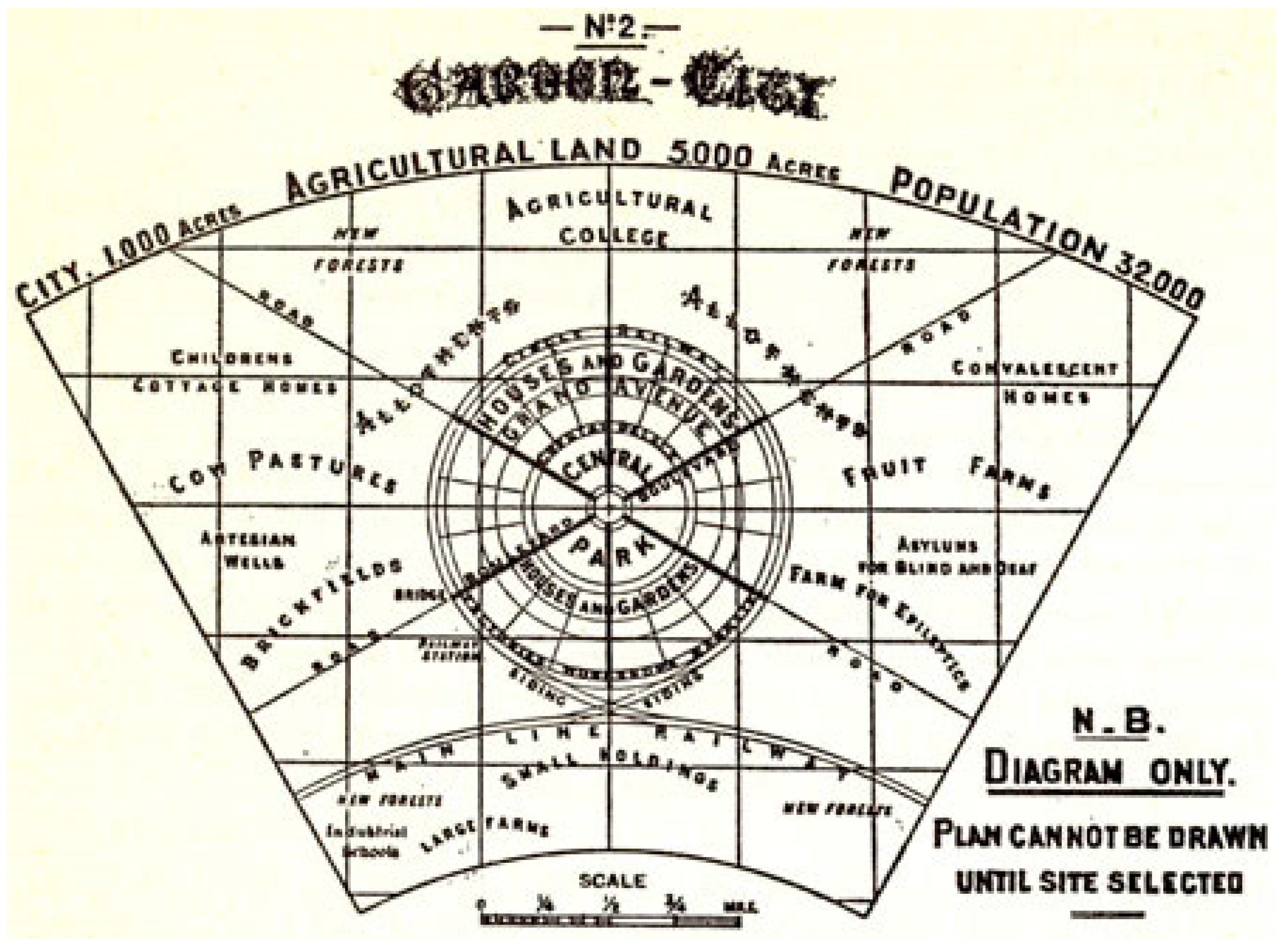
Howard’s ideal garden city would cover 6000 acres (that is 24.3 km2) and would house around 32,000 inhabitants [60], which means that the average density for these cities would be 1316 inhab/km2. Letchworth which was founded in 1905, and which is actually the first garden city built in the world, covers 5500 acres (22.3 km2) and has a population of 33,249 inhabitants [61], thus presenting an average density of 1491 inhabitants per sqm, similar to the ideal model defined by Howard. Welwyn, in which construction began 15 years later (in 1920), occupied 2377 acres (9.6 km2) and until 1956 housed less than 19,000 inhabitants, far below the maximum population planned which was 50,000 inhabitants. Thus the actual density of Welwyn was 1979 inhabitants/km2 for decades, below the level established as a reference of 5200 inhabitants/km2.
If we analyse “sustainable” city sizes shown as examples by regionalists, we realize the great divergence of sizes and characteristics. Baccini proposes “metabolic” urban designs to develop robust urban systems, and refers to the urban nucleus with populations ranging from 10–100 million inhabitants, with population densities ranging from 300–600 inhabitants/km2 [7]. In turn, another regional pattern established as a reference of regional balance of another era (Early Bronze Age) is the tells landscape in the Khabur Basin (Syrian Jazira nowadays), with each tell covering more than 1 km2, and housing between 10,000 to 20,000 people, and each one managed other smaller tell distributes every 10 km [62]. Thus the different regionalist researchers state that cities with different city sizes and densities can be regionally balanced. “Sustainable” city size and density has to be established on a case by case basis, however the main message here is that regional balance can only be reached if the urban form is contained and planned. Urbanization cannot take place as the result of particular needs; it has to be the result of a regionally orchestrated plan.
Even though the main focus of the regionalists was not actually in the tools used to communicate, convince, or implement their planning principles, the rejection of Adam’s Regional Plan of New York and Its Environs (RPNY) [63] did somehow open the debate regarding the manipulation of scientific arguments to defend a specific urban vision. Mumford actually denounced the use of empirical studies to narrow the depth of the urban planning discussion [28]. The post-war era was actually characterized by the technification of the urban planning discipline, which ended up pulling it out of the public debate [64]. The debate on the use of scientific findings to defend a particular urban vision is still in force; Echevarría Icaza L et al. investigated mapping strategies to suggest UHI mitigation measures accurate (and scientifically proven) enough to actually reduce the urban heat, and open enough to ensure their compatibility with other city priorities [65].
3.2.2. Greenery Standards
Regionalists’ ideal garden city [60] establishes a total of 5265.5 acres (21.3 km2) of greenery for a city of 6000 acres (24.3 km2), so that around 87.8% of the city surface would be covered by different greenery typologies. Five thousand acres would be occupied by agricultural land, and the rest of the greenery would be located within the city area, as concentric garden rings: 5.5 acres of watered garden at the confluence of the boulevards, 145 acres of the Central Park encircled by the Crystal Palace, and finally the Grand Avenue which can actually be considered as an additional park of 115 acres (Figure 3). Considering a population of 32,000 inhabitants, in the city there would be a ratio of 33.6 m2 per inhabitant. If we compare this ratio with the greenery thresholds established nowadays for different cities [66] such as Berlin (Germany), where the target is to have at least 6 m2 per person [67], or Leipzig (Germany) with a target of 10 m2 per inhabitant [68], the ratio of the garden city is more than three times the target of those cities.
Greener cities are cooler cities, and several researchers have attempted to quantify the cooling effect of greenery [69,70,71,72,73,74,75,76,77,78,79,80,81,82,83,84]. The temperature difference between the parks and their urban surroundings seems to depend on the size of the parks [71,75,85,86,87,88,89] and on the design of the park [78,90]. In turn, the cooling distance of the parks, which can range from 15 m [87] to 2000 m [71,85], seems to depend on the temperature difference. Thus the garden city proposal would also have prevented the formation of the UHI (Figure 4).
3.2.3. The Neighborhood Scale
In order to reach a regional balance, regionalists suggested not only guidelines at the regional scale, they also envisioned the materialization of the smaller (neighbourhood) and larger (supra-regional/infrastructural) scales.
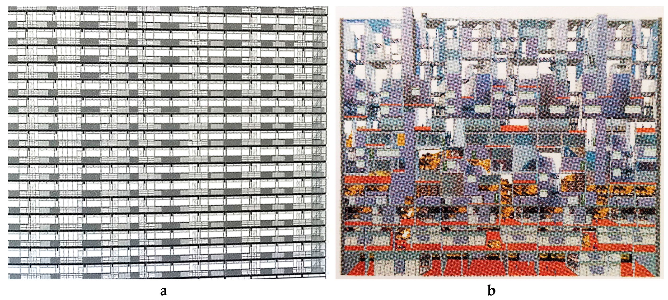
At the neighbourhood or community scale, the City Housing Corporation (CHC)—affiliated to the Regional Planning Association of America—attempted to build garden communities in Radburn and Sunnyside. In Sunnyside, streets and grids were already developed, and in order to create the communities a mix of housing typologies was proposed, ranging from row houses to apartment blocks with important interior gardens [91]. In Radburn the “super blocks” were developed, with large interior greenery and underpasses. We can find certain common aspects with the modernist post-war residential block prototype Unité D’Habitation or Cité Radieuse (in English “Radiant City”) proposed by Le Corbusier in the 1920s, and built for the first time in Marseille (from 1945 to 1952), which actually became after the 1929 crash a theoretical reflection on the materialization of urban concentration, as well as a proposal for the achievement of a certain degree of self-sufficiency (with the incorporation of offices, supermarkets, bakeries, cafeterias, hotel restaurants, book shops, nurseres, gyms, small swimming pools, open air auditoriums, etc.). The model proposed the concentration of density in the block, to be able to vacate the surrounding space, allowing a total integration of the block within the surrounding nature. The materialization of residential blocks interspersed with greenery was executed in the Netherlands and in many other European cities after World War II to overcome the housing shortage. Many of these residential blocks have failed to reach the “self-sufficiency” principle which was associated with the original block design, thus questioning the whole urban concentration model.
Several researchers have proposed design renovation strategies to actually prove that these block typologies actually represent a viable model as long as they are appropriately renovated. The program proposals include the introduction of mixed uses within the blocks (child day care and cafeterias on the ground floor, offices on the lower floors, and a common terrace on the upper floor), a mix of housing typologies (to accommodate students, families, the elderly, etc.) and the introduction of greenery in new private and common terraces [92] (Figure 5).
As far as the impact of these residential typologies on UHI is concerned, in The Netherlands, post war residential neighbourhoods seem to have a better thermal behaviour than conventional city centres [59,69], however, they could still benefit from the integration of greenery in the facades and rooftops, the use of highly reflective materials, and the creation of indoor cross ventilation [42]—which are also part of the design proposal for the community creation—as these would have a beneficial impact on the reduction of heat accumulation at the building block size.
4. Discussion
Even though revisiting the regionalist principles is inspiring for the creation of design guidelines for reducing the Urban Heat Island in new urban developments, it is important to highlight that these are precisely only applicable in certain contemporary scenarios. Thus Mumford’s concept of “reversal” is often no longer valid in the current context, since in the last 100 years automobile technology has in most cases only accentuated the ravages caused by the 19th century city that Mumford described in the 1920s, and thus in that sense the recovery of the garden city principles in an existing metropolis is no longer seems feasible. He referred to that “reversion phase” as “neotechnics”. Even though in the last century technology (automobile, railways, airplanes, etc.) has not really changed—at the local scale—its efficiency (reduction of transportation times) and cost (these transportation means are now available to a much larger portion of the global population) have improved considerably involving social exchanges at the global scales. The local infrastructure that allows cars, trains, and airplanes to operate have pretty much remained unchanged, thus its direct impact at the local scale remains limited. In turn, the increase in its efficiency and costs have allowed the true globalization of the planet, enabling flights around the world in less than 24 h and more than 100,000 flights worldwide. To a certain extent we can establish that the evolution of these transportation means has been critical for the consolidation of capitalism and globalization, which are identified as the indirect but true causes of urban unsustainability by many urban researchers. To some extent, the increase of the automobile and air traffic, allows for perpetuating unsustainable production/consumption patterns, involving aberrant food, material and human transportation distances, hazardous agricultural specialization regional patterns, and inadmissible daily CO2 emissions.
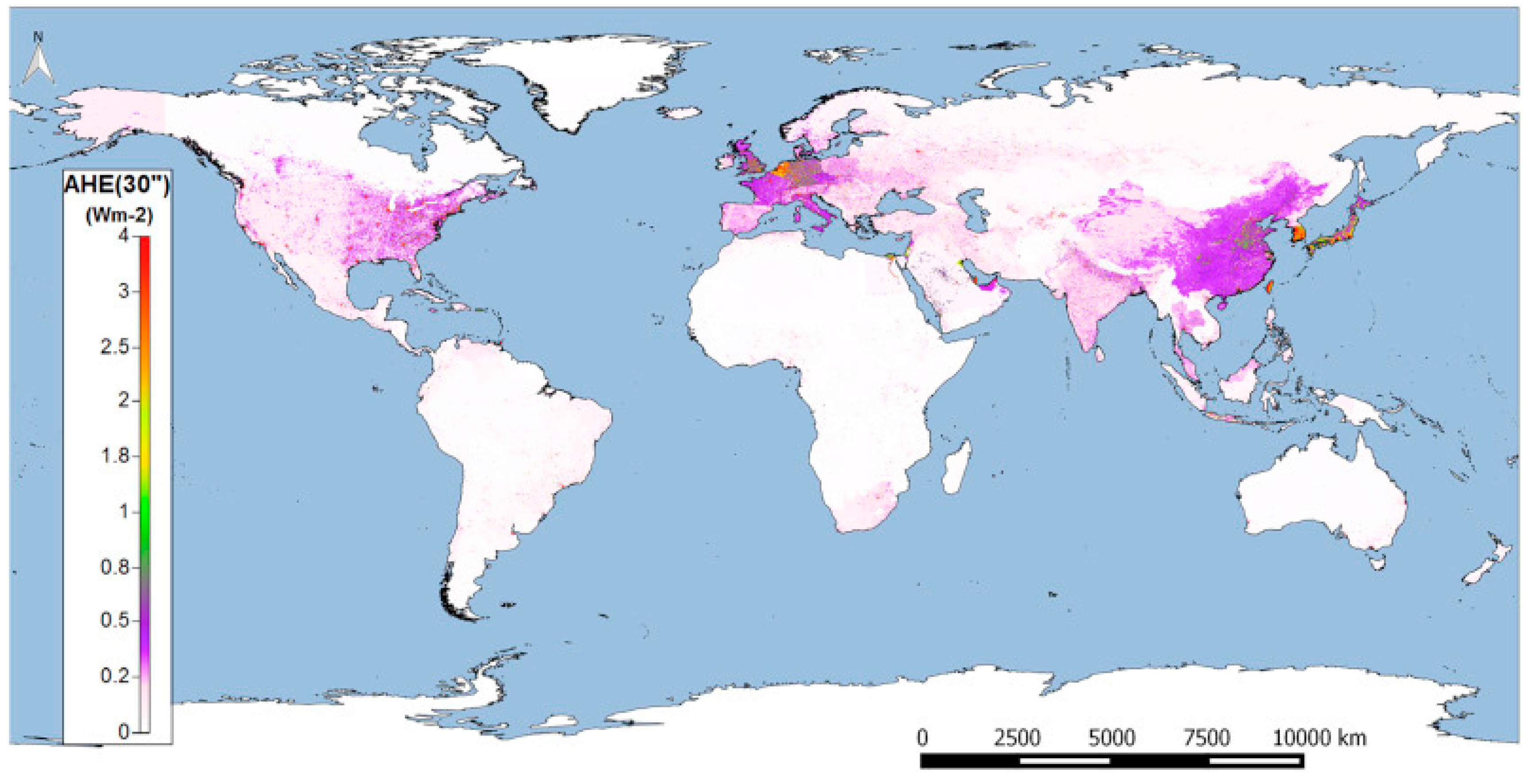
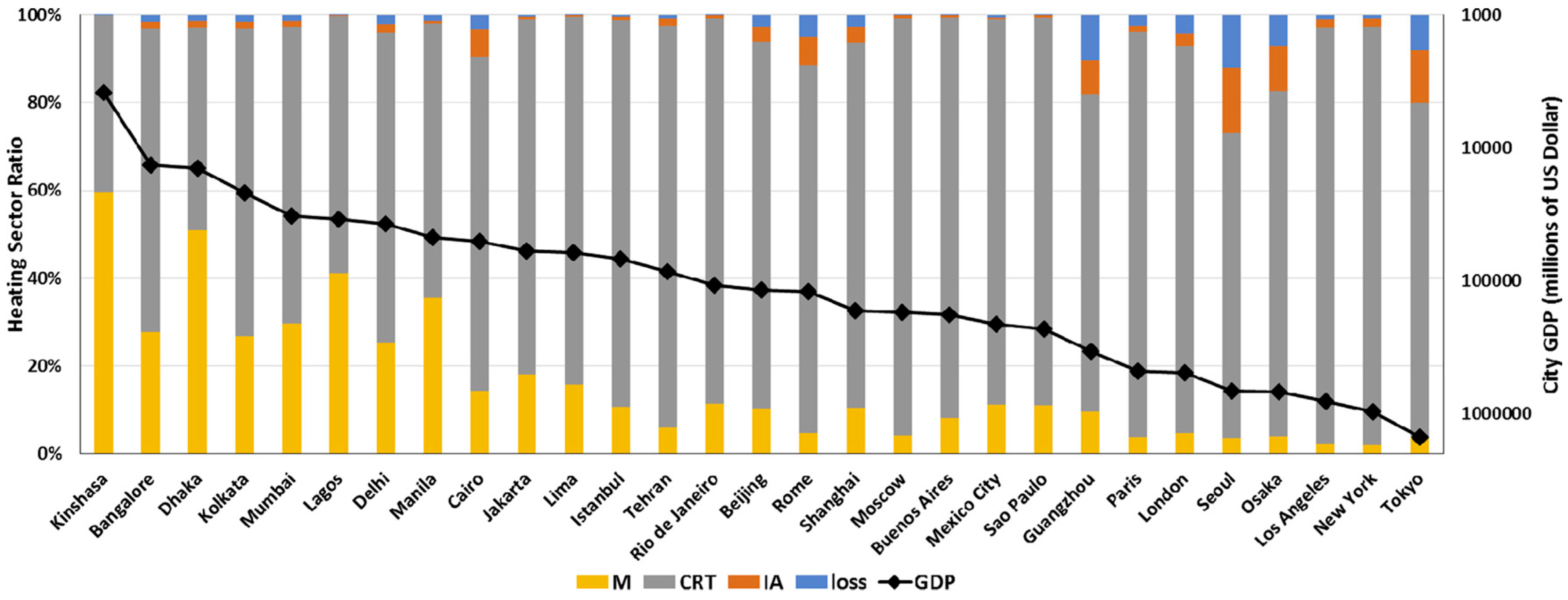
The UHI is aggravated by anthropogenic heat emissions, resulting from energy loss, and heating from commercial, residential, and transport sectors; heating from the industrial and agricultural sectors; and heating from human metabolism. Whereas in developing cities human metabolism is still a factor to be reckoned with, the contribution of the commercial, residential, and transport sectors increases rapidly alongside the increase in city level gross domestic product [73] (Figure 6 and Figure 7). The anthropogenic heat emission patterns that have emerged have reached a truly global scale.
As far as UHI mitigation is concerned, some measures can be introduced to palliate the UHI effect in existing cities, however others affect the structure of the city itself, which can only be implemented in urban areas built from scratch (not in existing ones). The UHI-related parameters affecting the structure of the cities are: the orientation of the streets [41] and the urban geometry (size and distance between buildings), which can actually be quantified by measuring the ratio of the height of the buildings by the width of the street [94] or the sky view factor (share of the sky observed from a point compared to the total sky hemisphere) [50,54,94].
5. Conclusions
The aim of this article is to answer two questions considering the regional territory principles and urban containment principles: Do the regionalist principles developed by Geddes and Mumford still apply to the 21st century urbanization context? If so, how would the implementation of these regionalist premises affect the UHI phenomenon?
The regional territory concept includes elements such as sense of place/the concept of nature and the regional economy. Enhancing and preserving large-scale regional geographical natural and/or green elements is still a very appropriate and much used approach to maintain quality of life at a regional scale. Reaching a regional balance between the population and resources, vegetation, and animal life has been a bigger challenge so far but also here the concept fits well in contemporary planning approaches.
From a UHI perspective, the measures that are part of “sense of place/the concept of nature” are often prescribed to mitigate the UHI effect. Climatologic plans typically foresee the creation of wind paths connecting these natural cooling sources to the urban hotspot areas.
However, the need to have a self-sustaining regional economy may require an agricultural specialisation that may put pressure on other native land use cover present at a regional scale (such as forests or water surfaces). This will not automatically help the reduction of the impact of the UHI.
The urban containment concept includes elements such as garden cities, size of the cities, greenery standards, and the neighbourhood scale. Attempts to limit the growth of the cities’ actual footprint is still relevant in present times. With the current growth of the urban population it will not be possible to achieve such an objective by using the densities proposed in the original garden city concepts. The opposition to the scientific underpinning of urban plans by the regionalists is in the current data-driven society a lost cause. The need for citizen involvement and public debate on spatial plans on the other hand is growing. The greenery standards applied in such garden cities are far from what is realistic in current cities. However, the materialization of residential blocks interspersed with greenery did find a broad acceptance.
From a UHI perspective, garden cities would perform best, the use of scientific findings is essential, greenery standards can be useful to reduce the impact of the UHI, and the application of greening principles on a neighbourhood scale is recognised as an indispensable instrument in climate proofing cities.
Overall we can conclude that most key elements of the regionalist concept are still very much relevant today and would indeed help to reduce the impact of the Urban Heat Island. The garden city idea requires a revision.
Acknowledgments
This research is funded by the Climate Proof Cities Consortium of the Knowledge for Climate research project.
Author Contributions
Leyre Echevarría Icaza has been responsible for the overall research design, and the overall communication of the results of the project: texts, graphics and publications. Leyre Echevarría Icaza drafted also the manuscript. Frank van der Hoeven are responsible for the supervision of the Ph.D. research, and both revised the manuscript critically for important intellectual content. Both authors read and approved the final manuscript.
Conflicts of Interest
The authors declare no conflict of interest.
References
- Meadows, D.H.; Randers, J.; Behrens, W.W., III. The Limits to Growth: A Report to the Club of Rome (1972); Universe Books: New York, NY, USA, 1972. [Google Scholar]
- Hajer, M.; Dassen, T. Smart about Cities. Visualising the Challenge for 21st Century Urbanism; Nai010 Publishers & PBL Publishers: Rotterdam, The Netherlands, 2014. [Google Scholar]
- Ibañez, D.; Katsikis, N. (Eds.) New Geographies 06. Grounding Metabolism; Harvard University Press: Cambridge, MA, USA, 2014. [Google Scholar]
- Acebillo, J.; Caputo, P.; Giordano, P.; Vancheri, A.; Sassi, E.; Boskovic Sigon, S.; Martinelli, A. A New Urban Metabolism; i.CUP; Accademia di architettura, USI-Universita della Svizzera Italiana: Mendrisio CH, Italy, 2012. [Google Scholar]
- McHarg, I.L. American Museum of Natural History. In Design with Nature; Natural History Press: Garden City, NY, USA, 1969. [Google Scholar]
- Sitas, N.; Prozesky, H.E.; Esler, K.J.; Reyers, B. Exploring the Gap between Ecosystem Service Research and Management in Development Planning. Sustainability 2014, 6, 3802–3824. [Google Scholar] [CrossRef]
- Baccini, P. Understanding and Designing the Metabolism of Urban Systems. In New Geographies 06. Grounding Metabolism; Harvard University Press: Cambridge, MA, USA, 2014; pp. 28–37. [Google Scholar]
- Rockstrom, J.; Steffen, W.; Noone, K.; Persson, A.; Chapin, F.S.; Lambin, E.F.; Foley, J.; Crutzen, P.; Richardson, K.; Liverman, D.; et al. Planetary Boundaries: Exploring the Safe Operating space for Humanity. Ecol. Soc. 2009, 14, 32. [Google Scholar] [CrossRef]
- Rockstrom, J.; Steffen, W.; Noone, K.; Persson, A.; Chapin, F.S.; Lambin, E.F.; Lenton, T.M.; Scheffer, M.; Folke, C.; Schellnhuber, H.J.; et al. A Safe Operating space for Humanity. Nature 2009, 461, 472–475. [Google Scholar] [CrossRef] [PubMed]
- Ellis, E.C.; Ramankutty, N. Putting people in the map: Anthropogenic biomes of the world. Front. Ecol. Environ. 2008, 6, 439–447. [Google Scholar] [CrossRef]
- Ellis, E.C.; Klein, G.K.; Siebert, S.; Lightman, D.; Ramankutty, N. Anthropogenic transformation of the biomes 1700 to 2000. Glob. Ecol. Biogeogr. 2010, 19, 589–606. [Google Scholar] [CrossRef]
- Ellis, E.C. Ecologies of the Anthropocene. Global Upscaling of Social-Ecological Infrastructures. In New Geographies 06. Grounding Metabolism; Harvard University Press: Cambridge, MA, USA, 2014; pp. 20–27. [Google Scholar]
- Fischer-Kowalski, M.; Krausmann, F.; Pallua, I. A Sociometabolic Reading of the Anthropocene: Modes of Subsistence, Population Size and Human Impact on Earth. Anthr. Rev. 2014, 1, 8–33. [Google Scholar] [CrossRef]
- Raudsepp-Hearne, C.; Peterson, G.D.; Tengö, M.; Bennett, E.M.; Holland, T.; Benessaiah, K.; MacDonald, G.K.; Pfeifer, L. Untangling the Environmentalist’s Paradox: Why Is Human Well-being Increasing as Ecosystem Services Degrade? BioScience 2010, 60, 576–589. [Google Scholar] [CrossRef]
- Bernstein, W. The Birth of Plenty Bloomington; McGraw Hill: New York, NY, USA, 2004. [Google Scholar]
- UN. United Nations. World Population Prospects: The 2012 Revision; UN: New York, NY, USA, 2012. [Google Scholar]
- Kemp-Benedict, E.; Heaps, C.; Raskin, P. Global Scenario Group Futures: Technical Notes; PoleStar Series Report 9; Stockholm Environment Institute: Stockholm, Sweden, 2002. [Google Scholar]
- Angel, S. Planet of Cities; The Lincoln Institute of Land Policy: Cambridge, MA, USA, 2012. [Google Scholar]
- Romano, B.; Zullo, F. Models of Urban Land Use in Europe Assessment tools and criticalities. Int. J. Agric. Environ. Inf. Syst. 2013, 4, 80–97. [Google Scholar] [CrossRef]
- UN General Assembly. Transforming Our World: The 2030 Agenda for Sustainable Development; UN: New York, NY, USA, 2015. [Google Scholar]
- Shahmohamadi, P.; Che-Ani, A.I.; Maulud, K.N.A.; Tawil, N.M.; AbdullahM, N.A.G. The Impact of Anthropogenic Heat on Formation of Urban Heat Island and Energy Consumption Balance. Urban Stud. Res. 2011, 2011, 497524. [Google Scholar] [CrossRef]
- Oke, T.R. Boundary Layer Climates, 2nd ed.; Routledge Press: New York, NY, USA, 1987. [Google Scholar]
- McCarthy, M.P.; Best, M.J.; Betts, R.A. Climate change in cities due to global warming and urban effects. Geophys. Res. Lett. 2010, 37, 232–256. [Google Scholar] [CrossRef]
- Mumford, L. The City in History; Harvest Books Harcourt: New York, NY, USA, 1961. [Google Scholar]
- Glaeser, E. The Triumph of the City: How Our Greatest Invention Makes Us Richer, Smarter, Greener, Healthier and Happier; Penguin Press: New York, NY, USA, 2011. [Google Scholar]
- UN. United Nations. World Urbanization Prospects. The 2014 Revision; UN: New York, NY, USA, 2014. [Google Scholar]
- Barriopedro, D.; Fischer, E.M.; Luterbacher, J.; Trigo, R.M.; García-Herrera, R. The Hot Summer of 2010: Redrawing the Temperature Record Map of Europe. Science 2011, 332, 220–224. [Google Scholar] [CrossRef] [PubMed]
- Luccarelli, M. Lewis Mumford and the Ecological Region: The Politics of Planning; Guilford Press: New York, NY, USA, 1995. [Google Scholar]
- Jacobson, M.Z.; Ten Hoeve, J.E. Effects of Urban Surfaces and White Roofs on Global and Regional Climate. J. Clim. 2012, 25, 1028–1044. [Google Scholar] [CrossRef]
- Mumford, L. Regionalism and Irregionalism. Soc. Rev. 1927, 19, 277–288. [Google Scholar] [CrossRef]
- Mumford, L. Waardom and the State; Dial; LXVII: New York, NY, USA, 1919; pp. 303–305. [Google Scholar]
- Grimmond, C.S.B.; Oke, T.R. Heat storage in urban areas: Observations and Evaluation of a simple model. J. Appl. Meteorol. 1999, 28, 922–940. [Google Scholar] [CrossRef]
- Sailor, D.J. Simulate urban climate response to modifications in surface albedo and vegetative cover. J. Appl. Meteorol. 1995, 34, 1694–1704. [Google Scholar] [CrossRef]
- Geddes, P. Cities in Evolution: An Introduction to the Town Planning Movement and to the Study of Civics; Williams: London, UK, 1915. [Google Scholar]
- MacKaye, B. The New Exploration: A Philosophy of Regional Planning; The Appalachian Trail Conference Harpers Ferry, West Virginia and The University of Illinois Press: Urbana, IL, USA, 1928. [Google Scholar]
- Mumford, L. Regions—to live in. In The Survey; Survey Associates Inc.: New York, NY, USA, 1925; pp. 91–92. [Google Scholar]
- Mumford, L. Technics and Civilization; Mariner Books: New York, NY, USA, 1963. [Google Scholar]
- Moore, J.W. Toward a Singular Metabolism. Epistemic Rifts and Environment-Making in the Capitalist World-Ecology. In New Geographies 06. Grounding Metabolism; Harvard University Press: Cambridge, MA, USA, 2014. [Google Scholar]
- Office for Environmental Protection, Section of Urban Climatology. Climate Atlas for the region of Stuttgart; Office for Environmental Protection: Washington, DC, USA, 2008. [Google Scholar]
- Burghardt, R.; Katzschner, L.; Kupski, S.; Ren, C.; Spit, T. Urban Climatic Map of Arnhem City; Future Cities: Arnhem, The Netherlands, 2010. [Google Scholar]
- Japan for Sustainability. Available online: http://www.japanfs.org/en/news/archives/news_id027856.html (accessed on 22 June 2016).
- Yamamoto, Y. Measures to Mitigate Urban Heat Islands; Quarterly Reviewn No. 18; Environment and Energy Research Unit, Science and Technology Foresight Center: Osaka, Japan, 2006. [Google Scholar]
- Ichinose, T. Urban Planning and Wind Paths. In Environment Climatology; Yoshino, M., Fukuoka, Y., Eds.; University of Tokyo Press: Tokyo, Japan, 2003. [Google Scholar]
- Congress of the New Urbanism. 2016. Available online: https://www.cnu.org/who-we-are/charter-new-urbanism (accessed on 25 June 2016).
- Zeeuw, H.D. Cities, Climate Change and Urban Agriculture. Urban Agric. Mag. 2011. Available online: www.ruaf.org (accessed on 25 June 2016).
- UN-HABITAT. Report of the International Tripartite Conference on Urban Challenges and Poverty Reduction in African, Caribbean and Pacific Countries; UN-HABITAT: Nairobi, Kenya, 2009. [Google Scholar]
- Echevarria Icaza, L.E.; Van Den Dobbelsteen, A.; Van der Hoeven, F. Using satellite imagery analysis to classify and redesign provincial parks for a better cooling effect on cities: The case study of South Holland. Res. Urban. Ser. 2016, 4, 157–184. [Google Scholar]
- MacKaye, B. The Townless Highway; New Republic: New York, NY, USA, 1930; pp. 93–95. [Google Scholar]
- Oke, T.R. City size and the urban heat island. Atmos. Environ. 1973, 7, 769–779. [Google Scholar] [CrossRef]
- Hove, L.W.A.; Steeneveld, G.J.; Jacobs, C.M.J.; Heusinkveld, B.G.; Elbers, J.A.; Moors, E.J.; Holtslag, A.A.M. Exploring the Urban Heat Island Intensity of Dutch Cities; Alterra Report 2170; Alterra: Wageningen, The Netherlands, 2011. [Google Scholar]
- Hawkins, T.W.B.; Stefanov, A.J.; Bigler, W.L.; Saffell, E.M. The role of rural variability in Urban Heat Island determination for Phoenix, Arizona. J. Appl. Meteorol. 2004, 43, 476–486. [Google Scholar] [CrossRef]
- Runnalls, K.E.; Oke, T.R. The urban heat island of Vancouver, BC. In Proceedings of the Second Urban Environment Symposium, Albuquerque, NM, USA, 2–6 November 1998; American Meteorological Society: Boston, MA, USA, 1988; pp. 84–87. [Google Scholar]
- Fukuoka, Y. Physical Climatological Discussion on Causal Factors of Urban Temperature; Memoirs Faculty Integrated Arts and Sciences, Hiroshima University: Hiroshima, Japan, 1983; pp. 157–178. [Google Scholar]
- Park, H.S. Variations in the Urban Heat Island Intensity Affected by Geographical Environments; Environmental Research Center Papers 11; The University of Tsukuba: Ibaraki, Japan, 1987. [Google Scholar]
- Sakakibara, Y.; Matsui, E. Relation between heat island intensity and city size indices/urban canopy characteristics in settlements of Nagaro Basin, Japan. Geogr. Rev. Jpn. 2005, 78, 812–824. [Google Scholar] [CrossRef]
- Park, H.-S. Features of the heat island in Seoul and its surrounding cities. Atmos. Environ. 1986, 20, 1859–1866. [Google Scholar] [CrossRef]
- Stein, C. Dinosaur Cities. Survey Graphic 7. In Planning the Fourth Migration; MIT Press: Cambridge, MA, USA, 1925; pp. 65–74. [Google Scholar]
- Stewart, I.D.; Oke, T.R. Local Climate Zones for Urban Temperature Studies. Bull. Am. Meteorol. Soc. 2012, 93, 1879–1900. [Google Scholar] [CrossRef]
- Echevarria Icaza, L.; van der Hoeven, F.; van den Dobbelsteen, A. Surface thermal analysis of North Brabant cities and neighborhoods during heat waves. TeMA J. Land Use Mobil. Environ. 2016, 9. [Google Scholar] [CrossRef]
- Howard, E. Garden Cities of Tomorrow; Sonnenschein & Co.: London, UK, 1902. [Google Scholar]
- Office National Statistics UK. 2011. Available online: http://www.ons.gov.uk/peoplepopulationandcommunity/populationandmigration/populationestimates (accessed on 20 April 2017).
- Salgueiro Barrio, R.; Chugh, A.; Leon, M. Petrified Metabolism as Urban Artifact. Tells and Artificial Topographies in the Khabur Basin, Syria. In New Geographies 06. Grounding Metabolism; Harvard University Press: Cambridge, MA, USA, 2014. [Google Scholar]
- GLP. Regional Plan of New York and Its Environs. Town Plan. Rev. 1932, 15, 123–136. [Google Scholar]
- Hall, P. Urban and Regional Planning; Routledge: London, UK, 1992. [Google Scholar]
- Echevarría Icaza, L.; van den Dobbelsteen, A.; van der Hoeven, F. Integrating Urban Heat Assessment in Urban Plans. Sustainability 2016, 8, 320. [Google Scholar]
- Kabisch, N.; Strohbach, M.; Haase, D. Green Surge. Internal Project Report on Inventory of Urban Green Space Demand for the Two Scale Levels, Ulls and European Urban Atlas Cities; Milestone NR MS 24. WP3; University of Copenhagen: Copenhagen, Denmark, 2015. [Google Scholar]
- Senatsverwaltung für Stadtentwicklung und Umwelt. Urban Green. 2013. Available online: http://www.stadtentwicklung.berlin.de/umwelt/stadtgruen/gruenanlagen/index.shtml (accessed on 20 April 2017).
- City of Leipzig. Umweltqualitätsziele und—Standards für die Stadt Leipzig. 2003. Available online: http://www.leipzig.de/fileadmin/mediendatenbank/leipzig-de/Stadt/02.3_Dez3_Umwelt_Ordnung_Sport/36_Amt_fuer_Umweltschutz/Publikationen/Indikatoren/Umweltqualitatsziele_und-standards_fur_die_Stadt_Leipzig.pdf (accessed on 20 April 2017).
- Echevarria Icaza, L.; van den Dobbelsteen, A.; van der Hoeven, F. The Urban Heat Island Effect in Dutch City Centers: Identifying relevant indicators and first explorations. In Implementing Climate Change Adaptation in Cities and Communities; Leal Filho, W., Adamson, K., Dunk, R., Azeiteiro, U.M., Illingworth, S., Alves, F., Eds.; Springer International Publishing AG: Cham, Switzerland, 2016. [Google Scholar]
- Huang, Y.J.; Akbari, H.; Taha, H.; Rosenfeld, A.H. The potential of vegetation in reducing summer cooling loads in residential buildings. J. Clim. Appl. Meteorol. 1987, 26, 1103–1116. [Google Scholar] [CrossRef]
- Jauregui, E. Influence of a large urban park on temperature and convective precipitation in a tropical city. Energy Build. 1990, 15, 457–463. [Google Scholar] [CrossRef]
- Taha, H.; Akbari, H.; Rosenfeld, A. Heat island and oasis effects of vegetative canopies: Micro-meteorological field-measurements. Theor. Appl. Climatol. 1991, 44, 123–138. [Google Scholar] [CrossRef]
- McPherson, E.G. Cooling urban heat islands with sustainable landscapes. In The Ecological City, Preserving and Restoring Urban Biodiversity; Platt, R.H., Rowntree, R.A., Muick, P.C., Eds.; University of Massachusetts Press: Boston, MA, USA, 1994; pp. 151–171. [Google Scholar]
- Spronken-Smith, R.A.; Oke, T.R. The thermal regime of urban parks in two cities with different summer climates. Int. J. Remote Sens. 1998, 19, 2085–2104. [Google Scholar] [CrossRef]
- Upmanis, H.; Eliasson, I.; Lindqvist, S. The influence of green areas on nocturnal temperatures in a high latitude city (Göteborg, Sweden). Int. J. Climatol. 1998, 18, 681–700. [Google Scholar] [CrossRef]
- Wong, N.H.; Yu, C. Study of green areas and urban heat island in a tropical city. Habitat Int. 2005, 29, 547–558. [Google Scholar] [CrossRef]
- Chen, Y.; Wong, N.H. Thermal benefits of city parks. Energy Build. 2006, 38, 105–120. [Google Scholar]
- Chang, C.R.; Li, M.H.; Chang, S.D. A preliminary study on the local cool-island intensity of Taipei city parks. Landsc. Urban Plan. 2007, 80, 386–395. [Google Scholar] [CrossRef]
- Lee, S.-H.; Lee, K.-S.; Jin, W.-C.; Song, H.-K. Effect of an urban park on air temperature differences in a central business district area. Landsc. Ecol. Eng. 2009, 5, 183–191. [Google Scholar] [CrossRef]
- Wong, N.; Tan, A.; Tan, P.; Sia, A.; Wong, N. Perception studies of vertical greenery systems in Singapore. J. Urban Plan. Dev. 2010, 136, 330–338. [Google Scholar] [CrossRef]
- Bowler, D.E.; Buyung-Ali, L.; Knight, T.M.; Pullin, A.S. Urban greening to cool towns and cities: A systematic review of the empirical evidence. Landsc. Urban Plan. 2010, 97, 147–155. [Google Scholar] [CrossRef]
- Shashua-Bar, L.; Pearlmutter, D.; Erell, E. The influence of trees and grass on outdoor thermal comfort in a hot-arid environment. Int. J. Climatol. 2011, 31, 1498–1506. [Google Scholar] [CrossRef]
- Tian, Y.; Jim, C.Y.; Tao, Y. Challenges and strategies for greening the compact city of Hong Kong. J. Urban Plan. Dev. 2012, 138, 101–109. [Google Scholar] [CrossRef]
- Cheng, X.; Wei, B.; Chen, G.; Li, J.; Song, C. Influence of Park Size and Its Surrounding Urban Landscape Patterns on the Park Cooling Effect. J. Urban Plan. Dev. 2014, 141. [Google Scholar] [CrossRef]
- Jauregui, E. Microclima del Bosque de Chapultepec; Bulletin No.6; Instituto de Geografia, University of Mexico: Mexico City, Mexico, 1975. (In Spanish) [Google Scholar]
- Oke, T.R. The micrometeorology of urban forest. Philos. Trans. R. Soc. B 1989, 324, 335–349. [Google Scholar] [CrossRef]
- Saito, I.; Ishihara, O.; Katayama, T. Study of the effect of green areas on the thermal environment in an urban area. Energy Build. 1990, 15, 493–498. [Google Scholar] [CrossRef]
- Ahmad, S.A. Some effects of urban parks on air temperature Tariations in Kuala Lumpar, Malaysia. Proceeding of the 2nd Tohwa University International Symposium (CUTEST’92), Fukuoka, Japan, 7–10 September 1992. [Google Scholar]
- Spronken-Smith, R.A. Energetics and Cooling in Urban Park. Unpublished Ph.D. Thesis, The University of British Columbia, Vancouver, BC, Canada, 1994. [Google Scholar]
- Li, X.; Zhou, W.; Ouyang, Z.; Xu, W.; Zheng, H. Spatial pattern of greenspace affects land surface temperature: Evidence from the heavily urbanized Beijing metropolitan area, China. Landsc. Ecol. 2012, 27, 887–898. [Google Scholar] [CrossRef]
- Wright, H. Rehousing Urban America; Columbia University Press: New York, NY, USA, 1935. [Google Scholar]
- Echevarria Icaza, L. Open and Transferable Architectonic Interventions for High Rise Dwelling Blocks; Archiprix 2004, The Best Plans by Dutch Students; 010 Publishers: Rotterdam, The Netherlands, 2004; pp. 48–50. [Google Scholar]
- Dong, Y.; Varquez, A.C.G.; Kanda, M. Global anthropogenic heat flux database with high spatial resolution. Atmos. Environ. 2017, 150, 276–294. [Google Scholar] [CrossRef]
- Oke, T.R. Canyon geometry and the nocturnal urban heat island: Comparison of scale model and field observations. J. Climatol. 1981, 1, 237–254. [Google Scholar] [CrossRef]
Figure 1.
Methodology scheme.

Figure 2.
List of the references reviewed to complete the regionalist principles analysis and the Urban Heat Island related literature at the regional, urban, and neighbourhood scales.
Figure 2.
List of the references reviewed to complete the regionalist principles analysis and the Urban Heat Island related literature at the regional, urban, and neighbourhood scales.

Figure 3.
Howard’s Garden city proposal. Diagram of the municipality ground-plan [61].
Figure 3.
Howard’s Garden city proposal. Diagram of the municipality ground-plan [61].

Figure 4.
Analysis of garden city and other regionalist model benchmarks for city size, density, and greenery standard.
Figure 4.
Analysis of garden city and other regionalist model benchmarks for city size, density, and greenery standard.
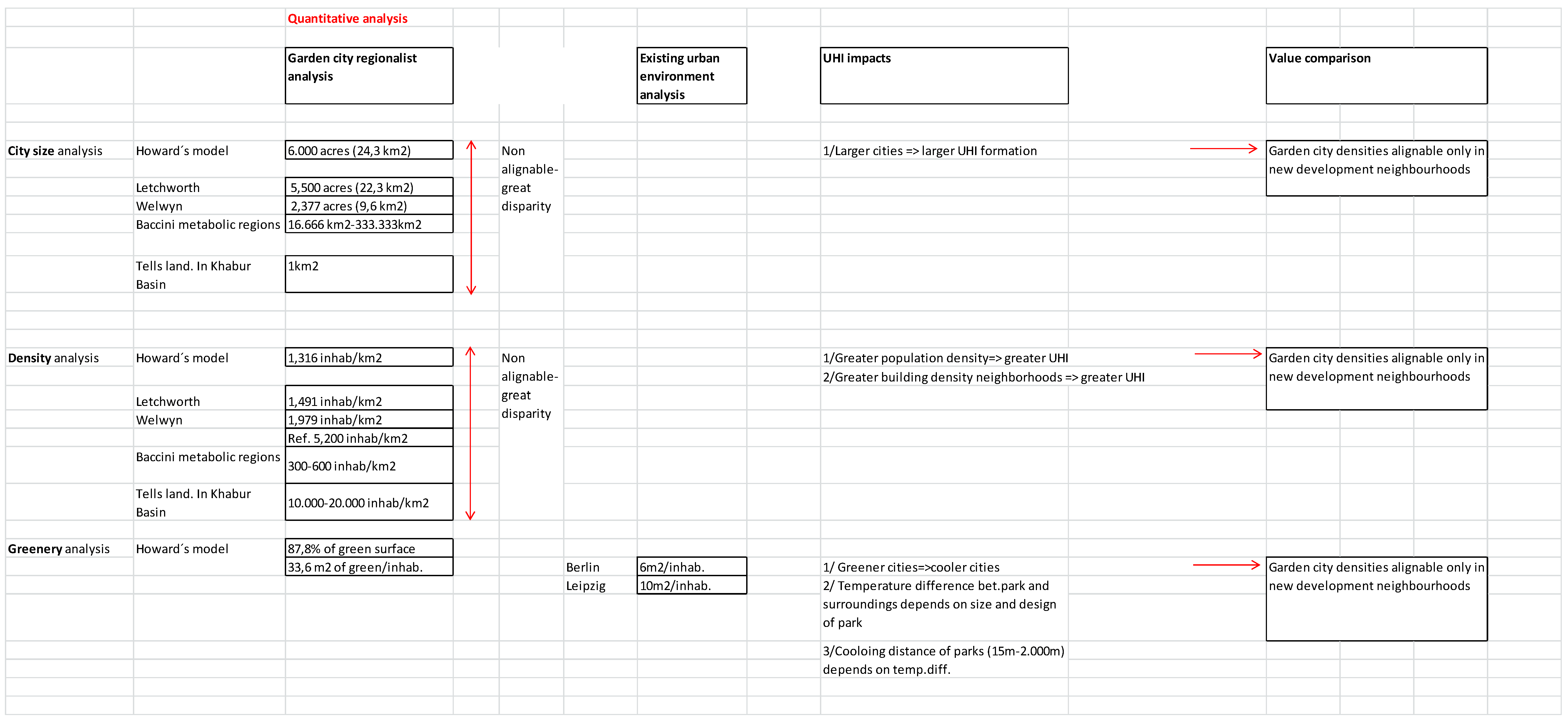
Figure 5.
Renovation proposal for the creation of a “community” within the post war residential blocks in The Netherlands. (a) Original block elevation. (b) Proposal [92].
Figure 5.
Renovation proposal for the creation of a “community” within the post war residential blocks in The Netherlands. (a) Original block elevation. (b) Proposal [92].

Figure 6.
Anthropogenic heat emissions: Annual averages with global coverage for 2013 [93].
Figure 6.
Anthropogenic heat emissions: Annual averages with global coverage for 2013 [93].

Figure 7.
Anthropogenic heat emissions: The percentage contribution of energy loss (loss), heating from commercial, residential, and transport sectors (CRT); heating from the industrial and agricultural sectors (IA); and heating from human metabolism (M). Bars represent the largest urban agglomerations. The dotted black line indicates the city-level gross domestic product in 2010 [93].

© 2017 by the authors. Licensee MDPI, Basel, Switzerland. This article is an open access article distributed under the terms and conditions of the Creative Commons Attribution (CC BY) license (http://creativecommons.org/licenses/by/4.0/).
Share and Cite
MDPI and ACS Style
Echevarría Icaza, L.; Van der Hoeven, F. Regionalist Principles to Reduce the Urban Heat Island Effect. Sustainability 2017, 9, 677. https://doi.org/10.3390/su9050677
AMA Style
Echevarría Icaza L, Van der Hoeven F. Regionalist Principles to Reduce the Urban Heat Island Effect. Sustainability. 2017; 9(5):677. https://doi.org/10.3390/su9050677
Chicago/Turabian StyleEchevarría Icaza, Leyre, and Franklin Van der Hoeven. 2017. "Regionalist Principles to Reduce the Urban Heat Island Effect" Sustainability 9, no. 5: 677. https://doi.org/10.3390/su9050677
Note that from the first issue of 2016, this journal uses article numbers instead of page numbers. See further details here.