Remote Sensing Intertidal Flats with TerraSAR-X. A SAR Perspective of the Structural Elements of a Tidal Basin for Monitoring the Wadden Sea


Abstract
:
1. Introduction
2. Materials and Methods
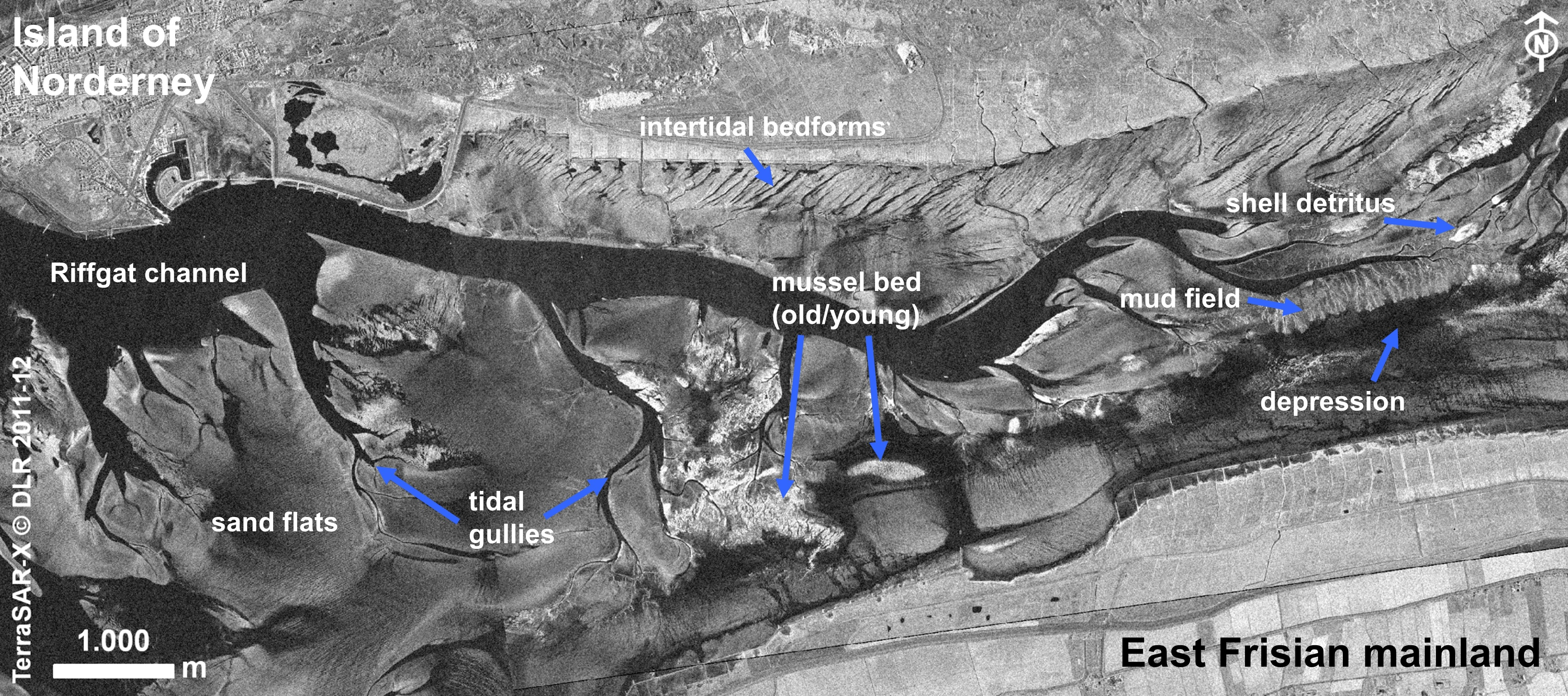
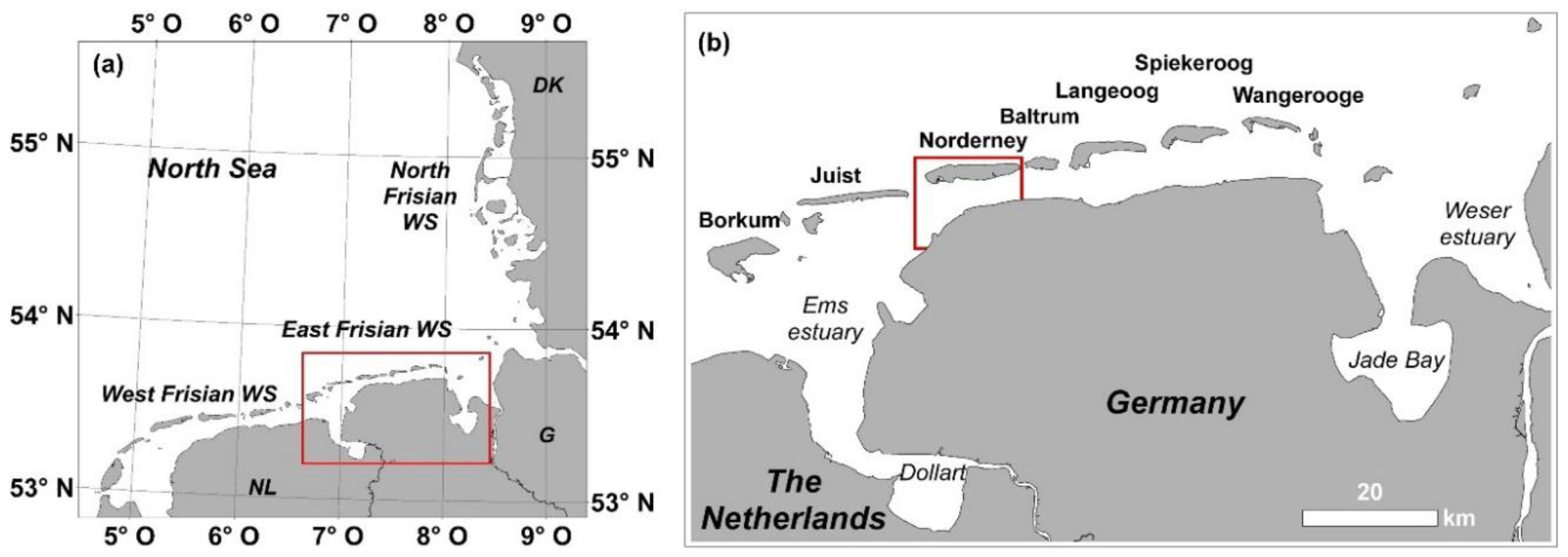
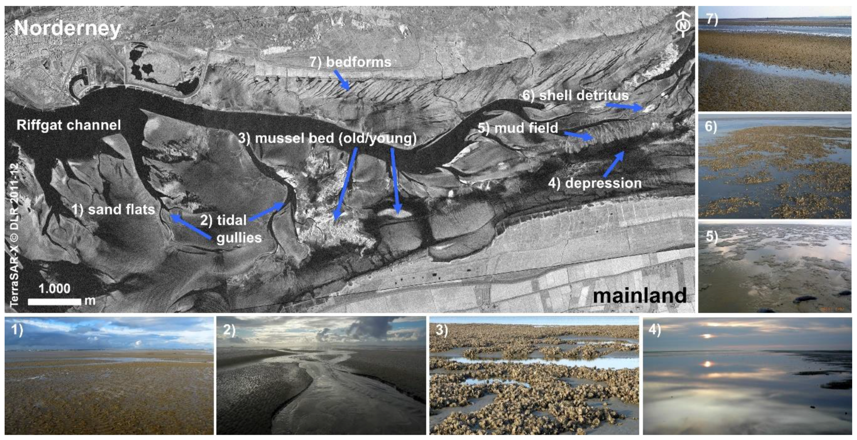
2.1. Study Site in the Tidal Flats of Norderney (German Wadden Sea)
2.2. TerraSAR-X Data Base
2.3. Image Analysis
2.3.1. Visual Image Analysis
2.3.2. Digital Image Analysis
2.4. Ground Truth, Monitoring and Environmental Data
3. Results
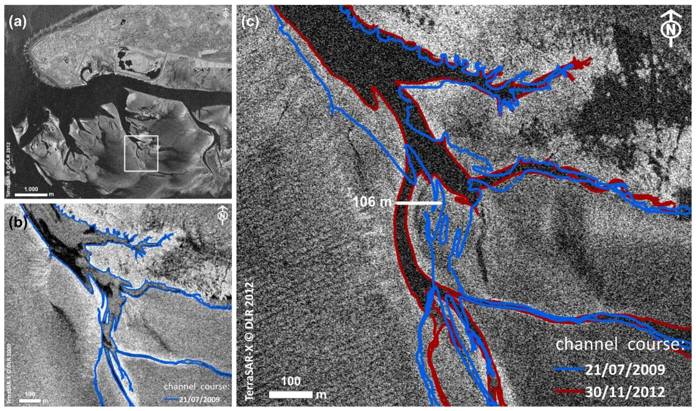
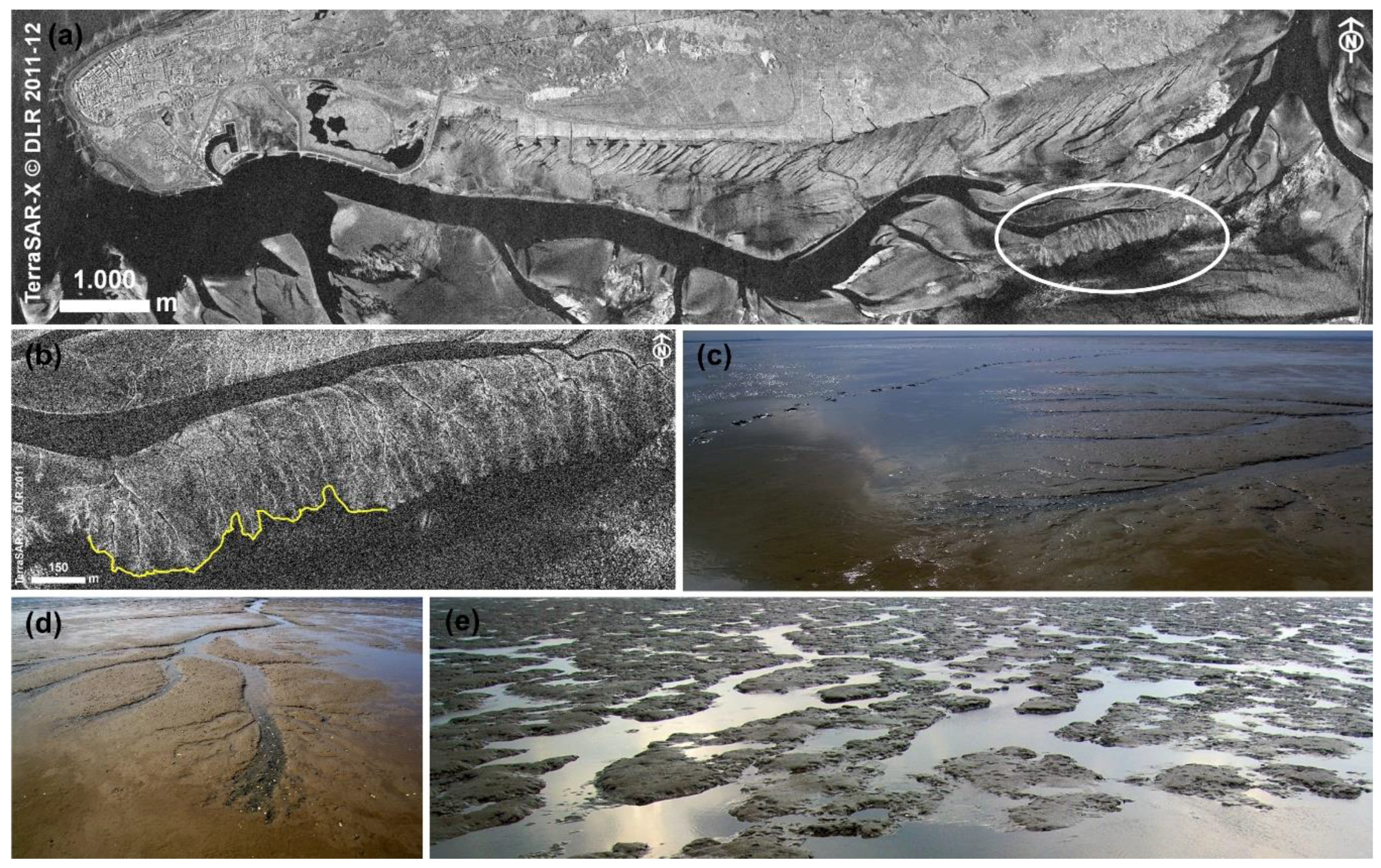
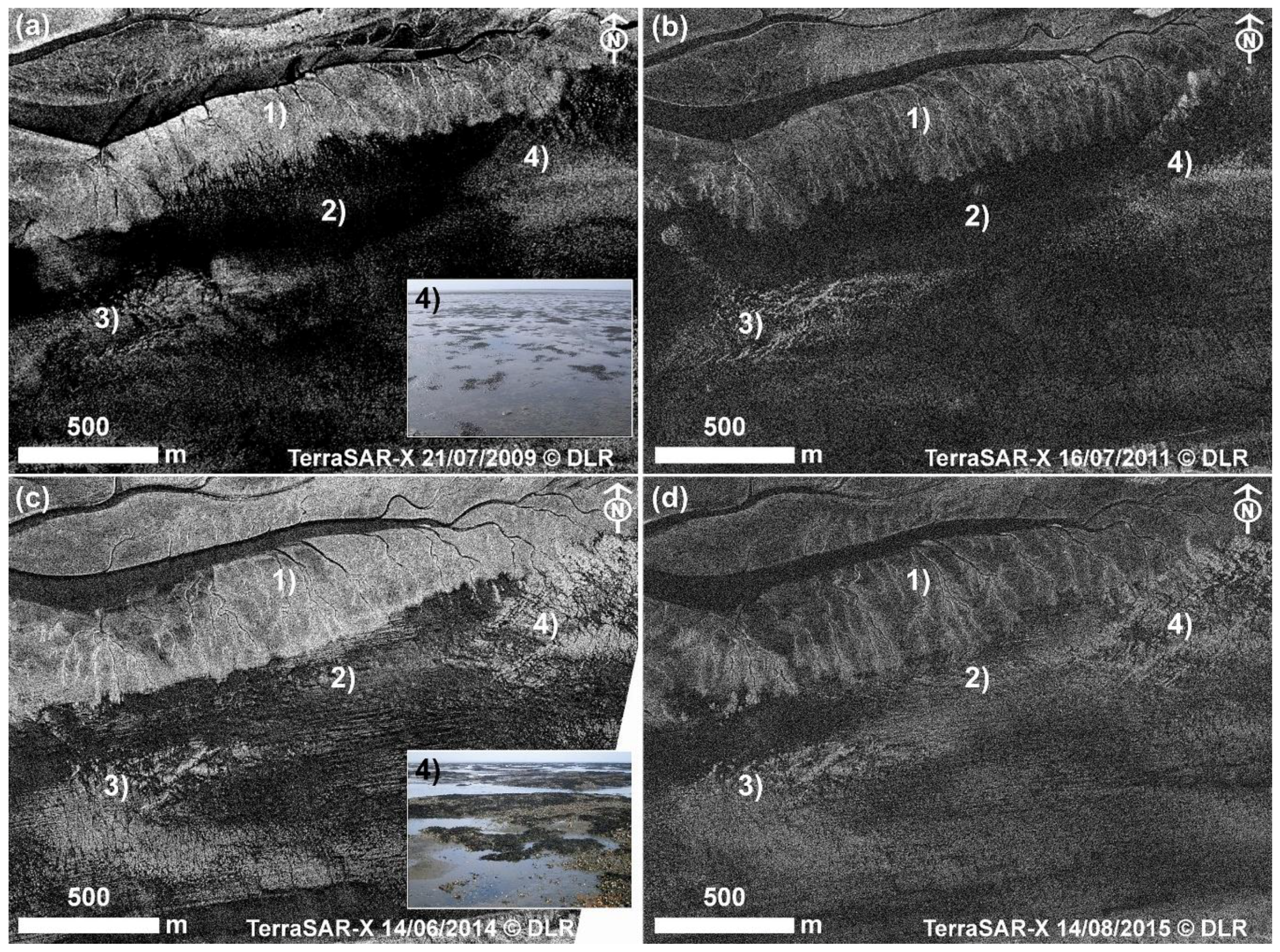
3.1. Tidal Channels and Gullies
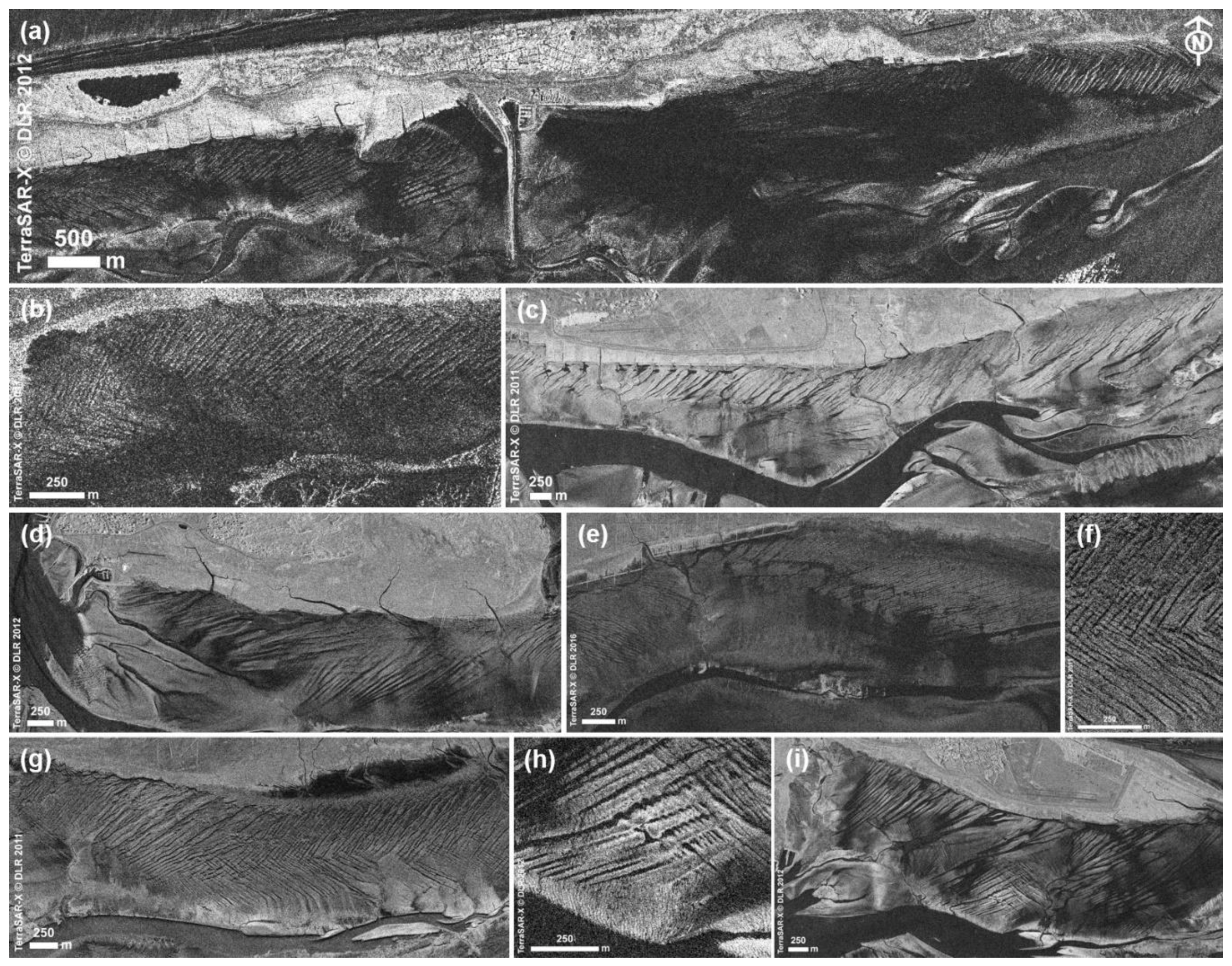
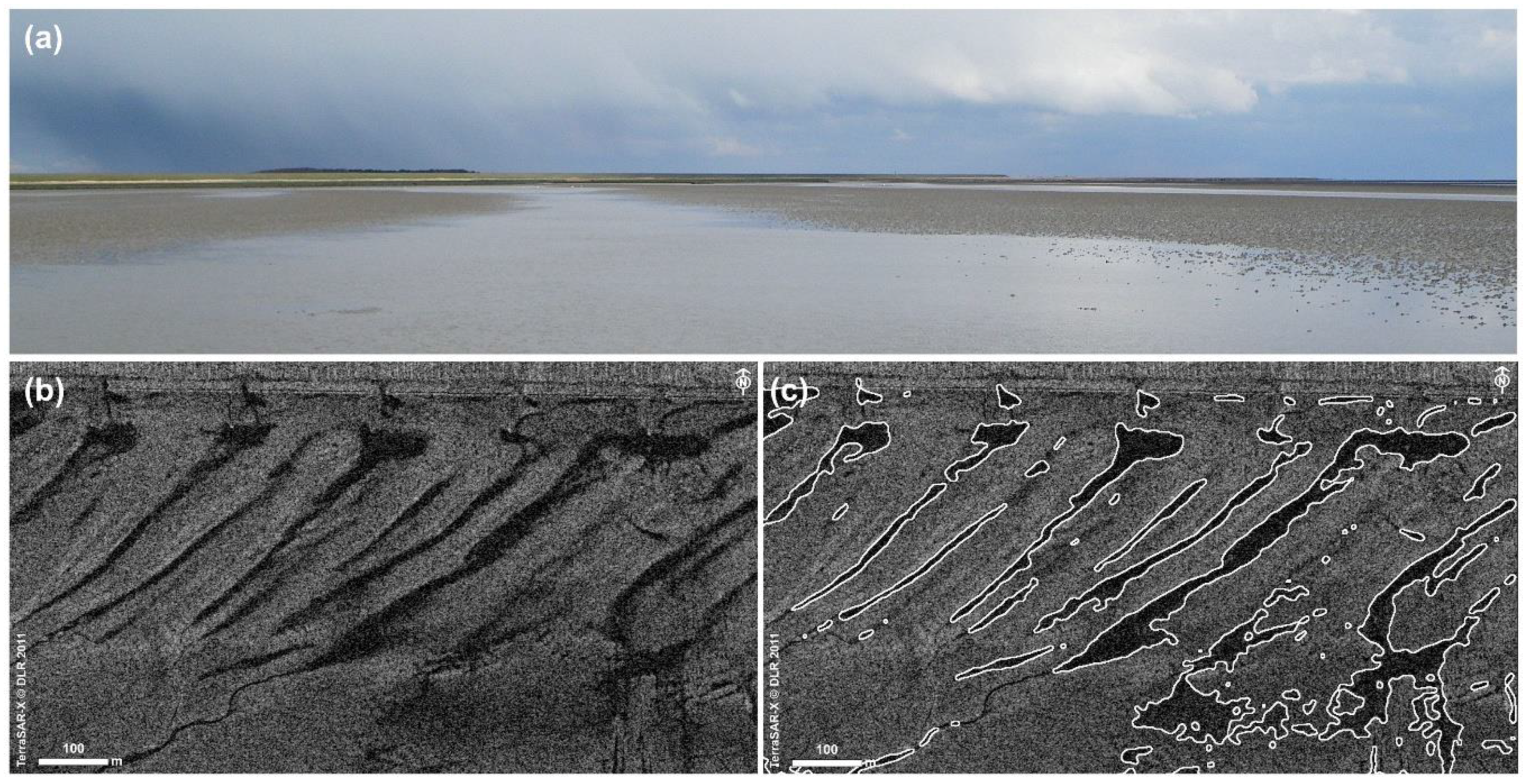
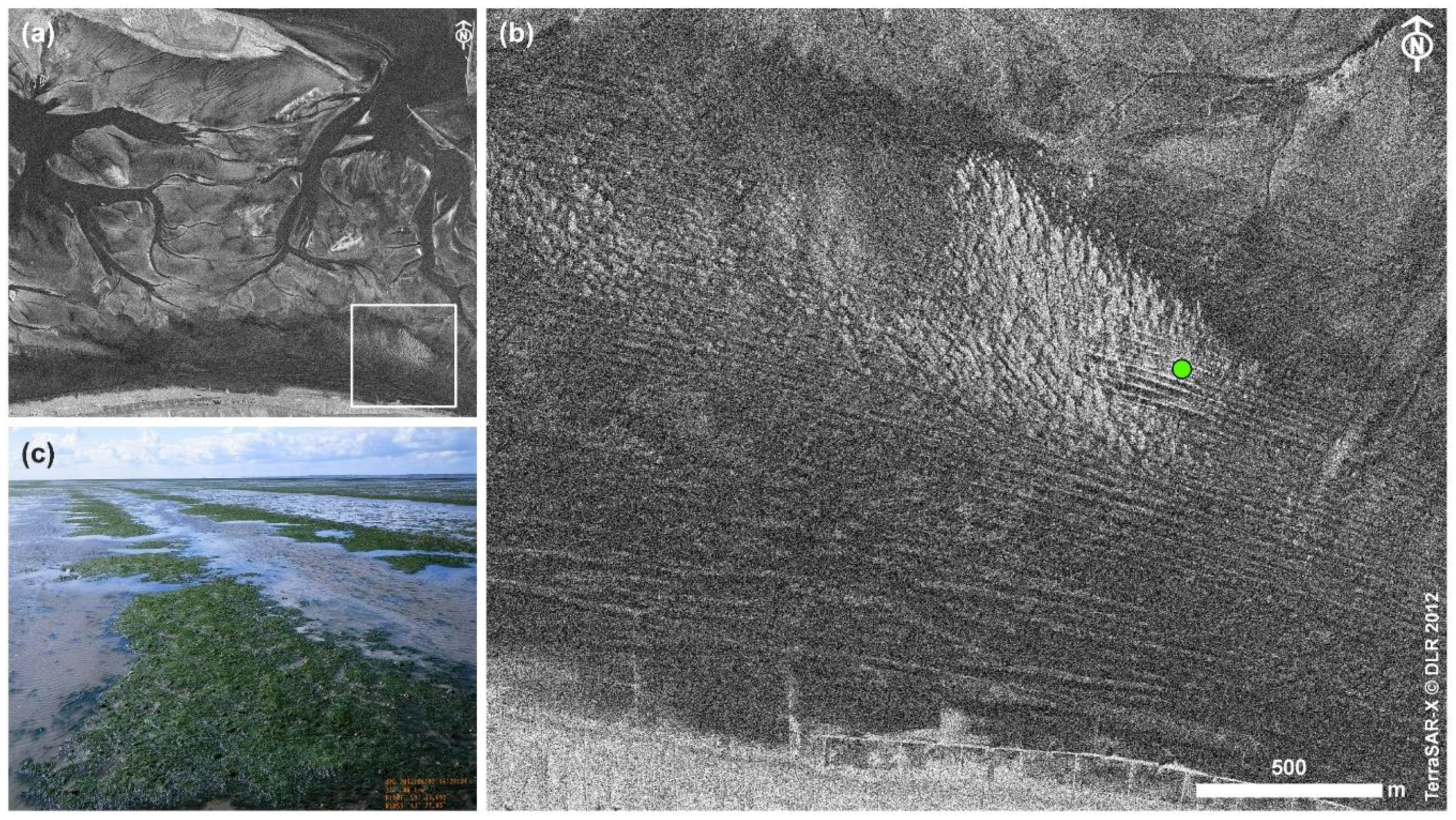
3.2. Intertidal Bedforms
3.2.1. Intertidal Bedforms in the Upper Island Flats of the East Frisian Islands
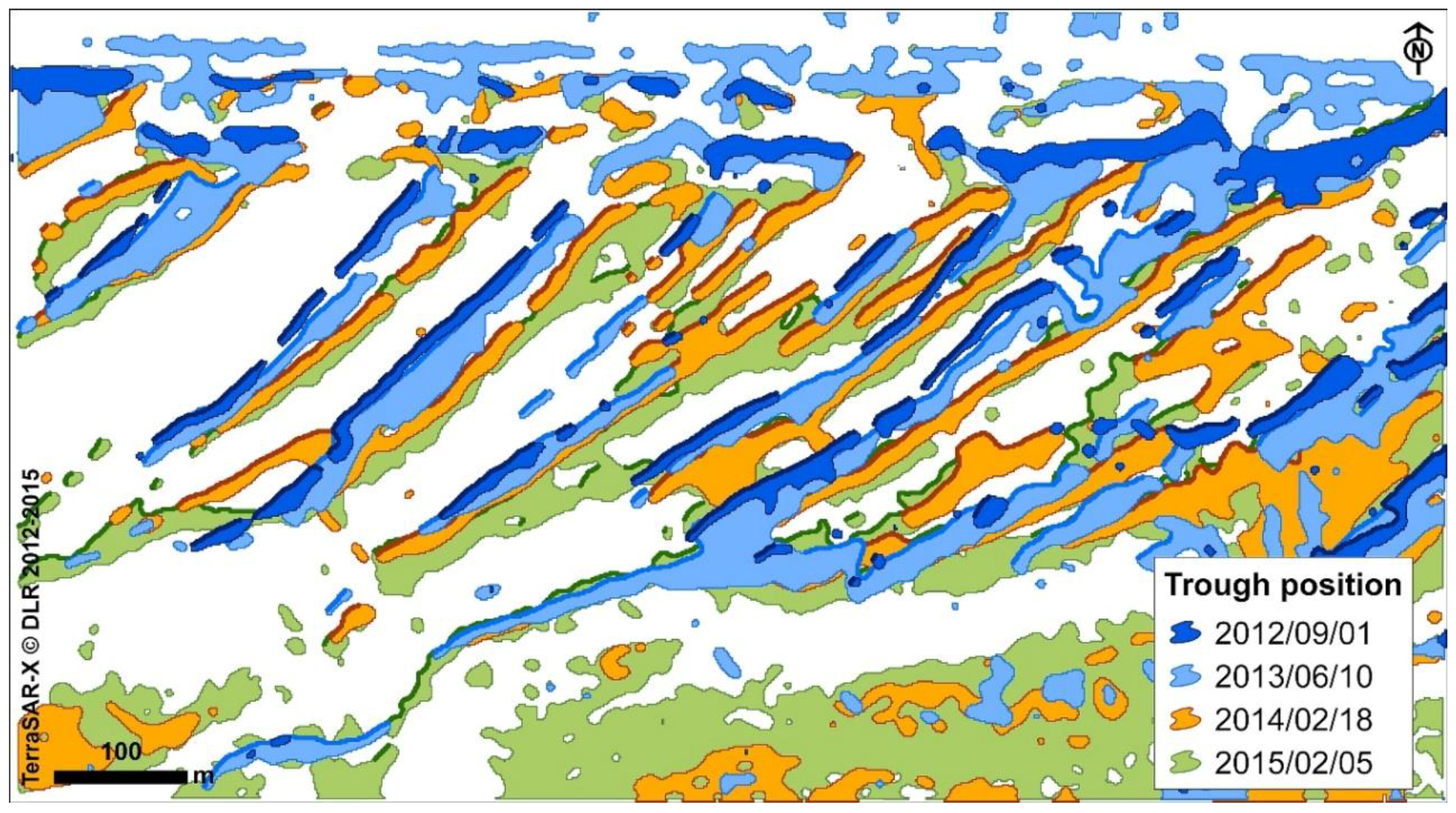
3.2.2. Temporary Surface Structures
3.3. Mud Field
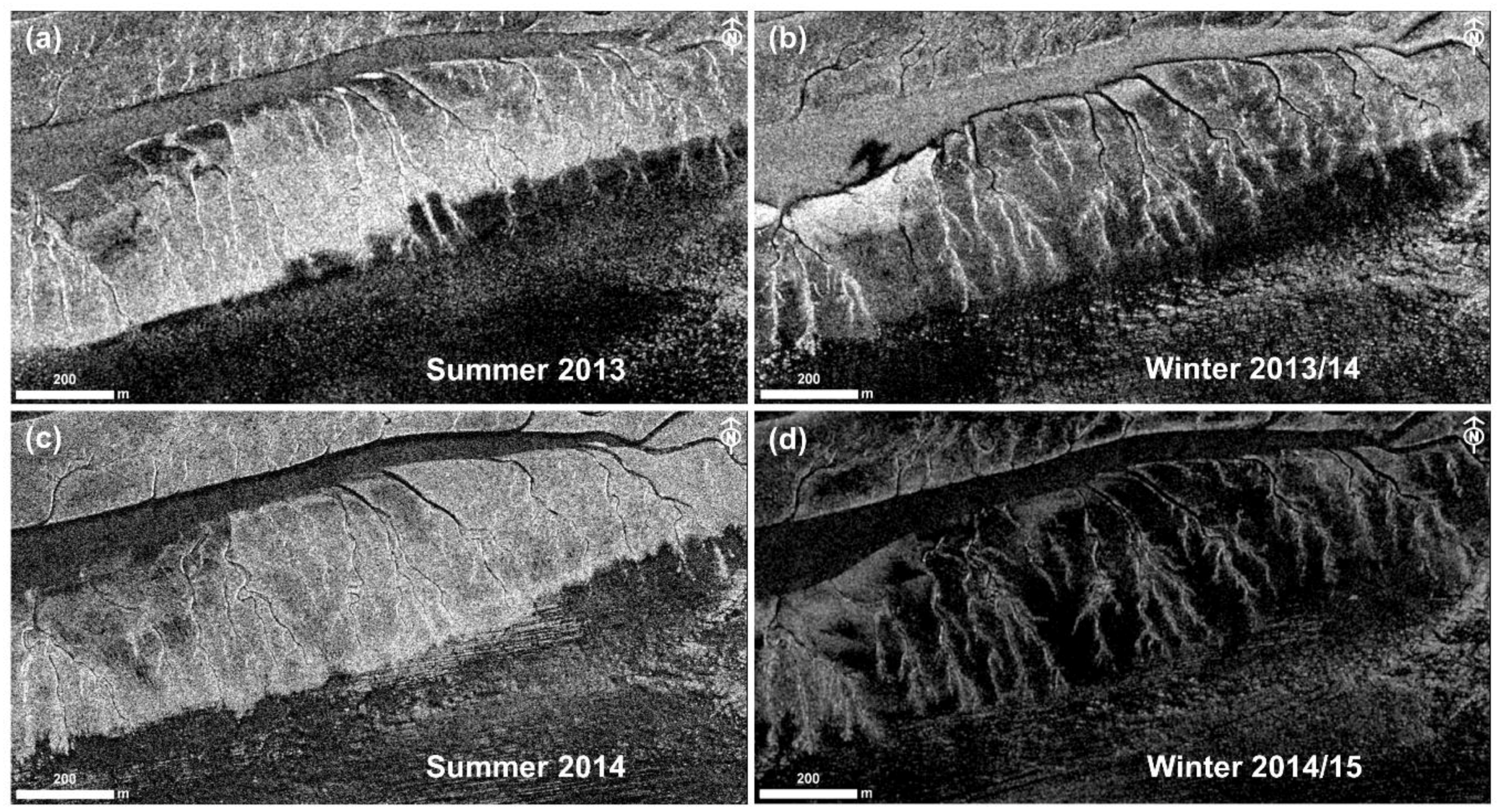
Seasonal Aspects
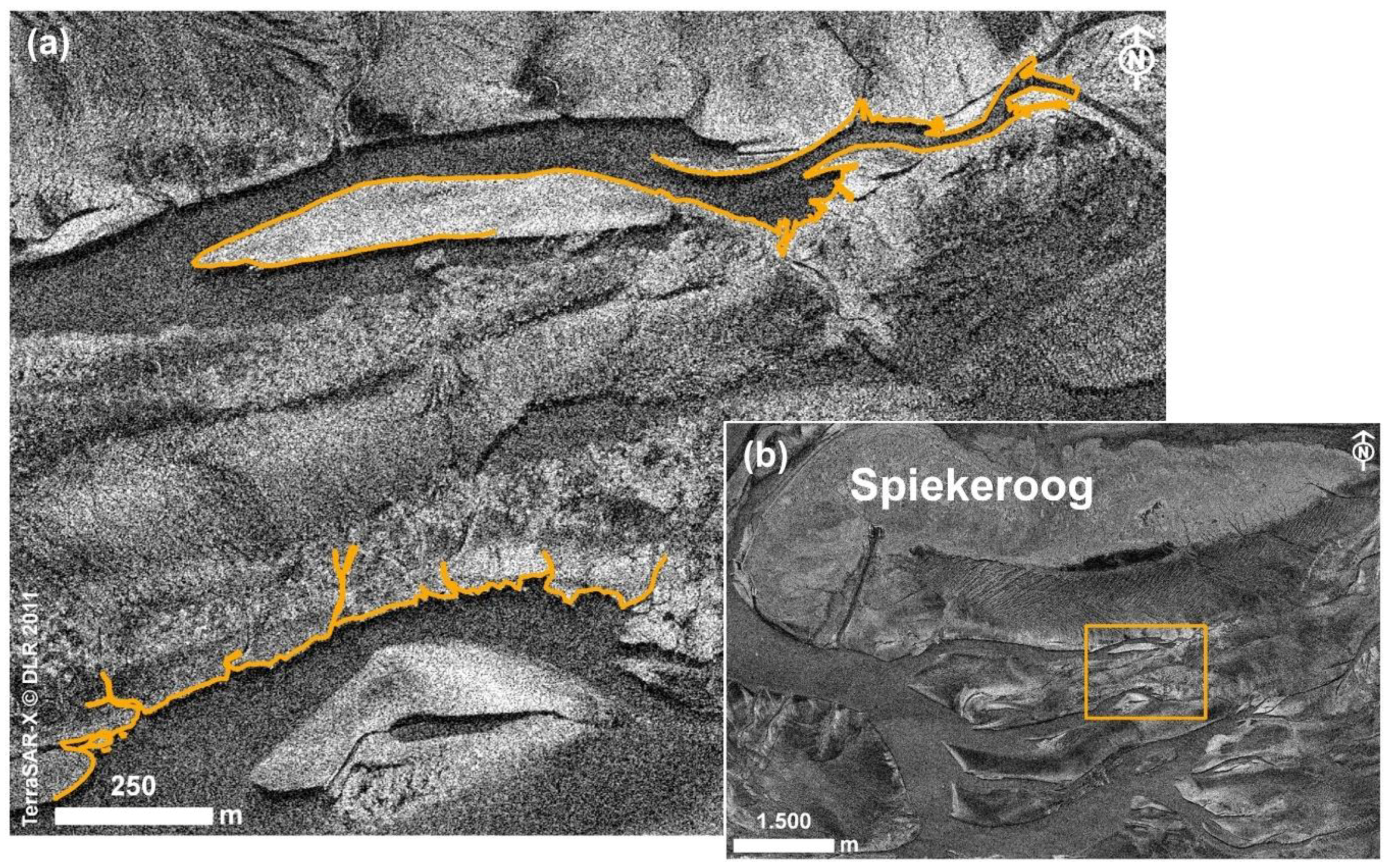
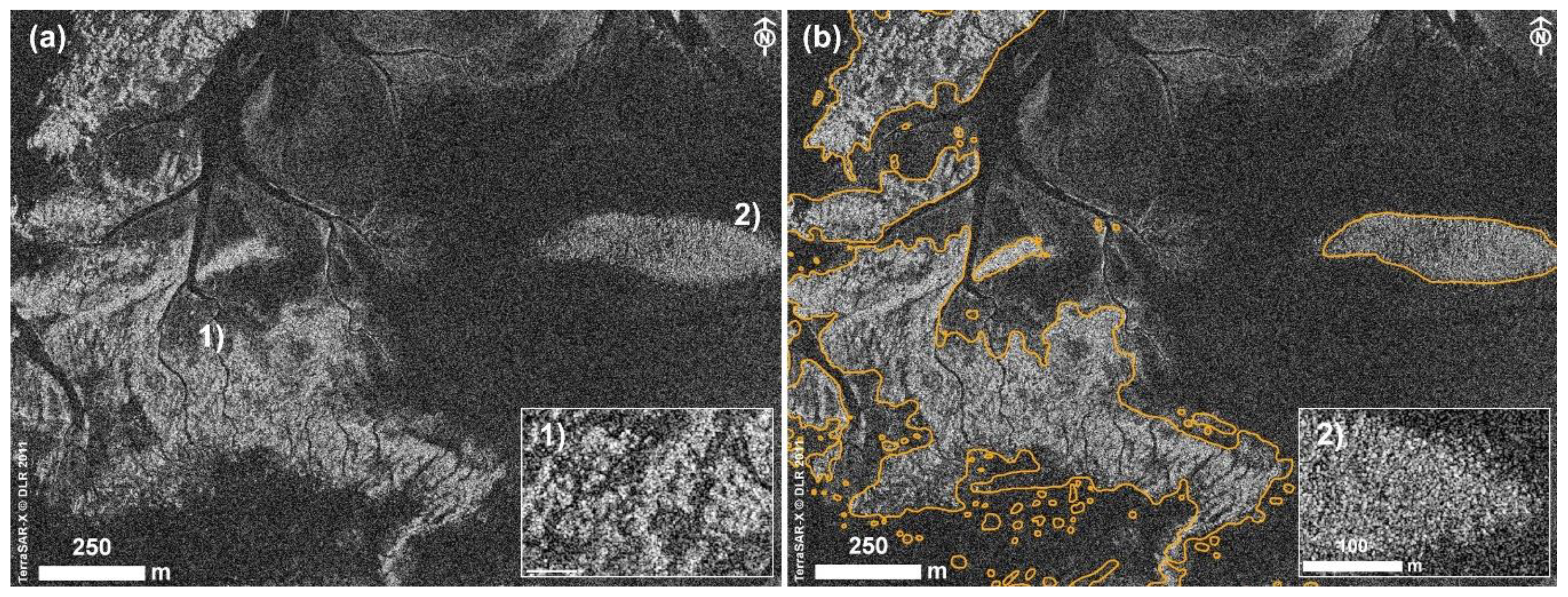
3.4. Mussel Beds
3.5. Tidal Flat Dynamics Imaged by TerraSAR-X
4. Discussion
4.1. Geometry of Acquisition
4.2. Environmental Influences—Water Cover
4.3. Visual Analysis and Classification
4.4. Contribution of Satellite SAR for Future Monitoring of Tidal Flats
5. Conclusions
- High-resolution SAR data as recorded by TerraSAR-X enables identification of essential geomorphic surface structures and habitats of the Wadden Sea ecosystem and their dynamics.
- Independence of SAR sensors from daylight and weather and a high repetition rate (11 days for TerraSAR-X) offer high temporal availability of data and allow to record long-term developments, short-term (e.g., seasonal) developments, and also event effects (e.g., storms, human intervention).
- Even in the spotlight modes providing highest spatial resolution, the footprint of one acquisition covers about the area of a tidal basin. This allows one to determine the status, size, and distribution of the intertidal macrostructures and habitats of a whole sub-unit of the Wadden Sea ecosystem.
- Visual interpretation of TerraSAR-X data combined with context information such as ground truth, monitoring results, or data on environmental conditions, both integrated in a GIS, proved to be a technically unsophisticated access to the information contained in the SAR data. As a first analysis approach, it can also provide basics for the further development of automatable classification methods.
- High-resolution SAR sensors can contribute relevant data for remote sensing the Wadden Sea. For future Wadden Sea monitoring or long-term ecological research, the combination or fusion of appropriate sensor data (e.g., SAR, multi-spectral data) is promising to significantly expand the interpretation options of advanced satellite-borne remote sensing techniques and to develop automated classification methods.
- In this study, the integration of diverse spatial data (such as large-scale remote sensing data and local sampling data) in a GIS has emerged as an essential component assisting the visual analysis. Beyond that, in a broader context, GIS allow to merge classification results and thus to compose a multifarious overall picture (respectively data base) of the Wadden Sea ecosystem which can support the inter-disciplinary analysis of complex relationships and processes.
- The overview of the geomorphic and biogenic structural elements and habitats of the Wadden Sea ecosystem, their spatial arrangement and dynamics, seen from the perspective of satellite remote sensing using both optical and SAR sensors should be used to contribute to a holistic approach to monitor and further explore the eco-morphological evolution of the tidal system of the Wadden Sea and related tidal systems worldwide.
Author Contributions
Funding
Acknowledgments
Conflicts of Interest
References
- Millat, G. Entwicklung Eines Methodisch-Inhaltlichen Konzeptes zum Einsatz von Fernerkundungsdaten für ein Umweltmonitoring im Niedersächsischen Wattenmeer; Schriftenreihe der Nationalparkverwaltung Niedersächsisches Wattenmeer: Wilhelmshaven, Germany, 1996; Volume 1, pp. 1–125. [Google Scholar]
- Herlyn, M.; Millat, G. Wissenschaftliche Begleituntersuchungen zur Aufbauphase des Miesmuschelmanagements im Nationalpark “Niedersächsisches Wattenmeer”; Abschlussbericht der Niedersächsischen Wattenmeerstiftung; Wilhelmshaven, Germany, 2004; (unpublished data). [Google Scholar]
- Herlyn, M. Quantitative assessment of intertidal blue mussel (Mytilus edulis L.) stocks: Combined methods of remote sensing, field investigation and sampling. J. Sea Res. 2005, 53, 243–253. [Google Scholar] [CrossRef]
- Ringot, J.L. Erstellen eines Interpretationsschlüssels und Kartierung der Biotoptypen terrestrischer Bereiche des Nationalparks Niedersächsisches Wattenmeer auf der Basis des CIR-Bildfluges vom 21.08.1991. 1992/1993; (unpublished data). [Google Scholar]
- Esselink, P.; Petersen, J.; Arens, S.; Bakker, J.P.; Bunje, J.; Dijkema, K.S.; Hecker, N.; Hellwig, U.; Jensen, A.-V.; Kers, A.S.; et al. Salt Marshes. Thematic Report No. 8. In Quality Status Report 2009—Wadden Sea Ecosystem 25; Marencic, H., Vlas, J., Eds.; Common Wadden Sea Secretariat, Trilateral Monitoring and Assessment Group: Wilhelmshaven, Germany, 2009. [Google Scholar]
- Petersen, J.; Dassau, O.; Dauck, H.-P.; Janinhoff, N. Applied vegetation mapping of large-scale areas based on high resolution aerial photographs—A combined method of remote sensing, GIS and near comprehensive field verification. Wadden Sea Ecosyst. 2010, 26, 75–79. [Google Scholar]
- Kolbe, K. Erfassung der Seegrasbestände im niedersächsischen Wattenmeer über visuelle Luftbildinterpretation—2008. Küstengewässer und Ästuare 2011, 4, 1–35. [Google Scholar]
- Moreira, A.; Prats-Iraola, P.; Younis, M.; Krieger, G.; Hajnsek, I.; Papathanassiou, K.P. A tutorial on synthetic aperture radar. IEEE Geosci. Remote Sens. Mag. 2013, 1, 6–43. [Google Scholar] [CrossRef] [Green Version]
- Stelzer, K.; Brockmann, C. Operationalisierung von Fernerkundungsmethoden fürs Wattenmeermonitoring (OFEW). Abschlussbericht. 2007. Available online: http://docplayer.org/7506004-Operationalisierung-von-fernerkundungsmethoden-fuer-das-wattenmeermonitoring-zusammenfassung.html (accessed on 27 April 2018).
- Stelzer, K.; Geißler, J.; Gade, M.; Eskildsen, K.; Kohlus, J.; Farke, H.; Reimers, H.-C. DeMarine Umwelt: Operationalisierung Mariner GMES-Dienste in Deutschland. Integration optischer und SAR Erdbeobachtungsdaten für das Wattenmeermonitoring; Jahresbericht 2009–2010; Bundesamt für Seeschifffahrt und Hydrographie: Hamburg, Germany, 2010; pp. 37–55. [Google Scholar]
- Müller, G.; Stelzer, K.; Smollich, S.; Gade, M.; Adolph, W.; Melchionna, S.; Kemme, L.; Geißler, J.; Millat, G.; Reimers, H.-C.; et al. Remotely sensing the German Wadden Sea—A new approach to address national and international environmental legislation. Environ. Monit. Assess. 2016, 188, 595. [Google Scholar] [CrossRef] [PubMed]
- Winter, C.; Backer, V.; Adolph, W.; Bartholomä, A.; Becker, M.; Behr, D.; Callies, C.; Capperucci, R.; Ehlers, M.; Farke, H.; et al. WIMO—Wissenschaftliche Monitoringkonzepte für die Deutsche Bucht; Abschlussbericht; 2016; pp. 1–159. Available online: http://dx.doi.org/10.2314/gbv:860303926 (accessed on 05 July 2018). [CrossRef]
- Winter, C. Monitoring concepts for an evaluation of marine environmental states in the German Bight. Geo-Mar. Lett. 2017, 37, 75–78. [Google Scholar] [CrossRef] [Green Version]
- Gade, M.; Alpers, W.; Melsheimer, C.; Tanck, G. Classification of sediments on exposed tidal flats in the German Bight using multi-frequency radar data. Remote Sens. Environ. 2008, 112, 1603–1613. [Google Scholar] [CrossRef]
- Jung, R.; Adolph, W.; Ehlers, M.; Farke, H. A multi-sensor approach for detecting the different land covers of tidal flats in the German Wadden Sea—A case study at Norderney. Remote Sens. Environ. 2015, 170, 188–202. [Google Scholar] [CrossRef]
- Gade, M. A polarimetric radar view at exposed intertidal flats. In Proceedings of the 2016 IEEE International Geoscience and Remote Sensing Symposium (IGARSS), Beijing, China, 10–15 July 2016. [Google Scholar]
- Jung, R. A Multi-Sensor Approach for Land Cover Classification and Monitoring of Tidal Flats in the German Wadden Sea. Ph.D. Dissertation, University of Osnabrueck, Osnabrueck, Germany, December 2015. [Google Scholar]
- Wang, W.; Yang, X.; Liu, G.; Zhou, H.; Ma, W.; Yu, Y.; Li, Z. Random Forest Classification of Sediments on Exposed Intertidal Flats Using ALOS-2 Quad-Polarimetric SAR Data. Int. Arch. Photogramm. Remote Sens. Spat. Inf. Sci. 2016, 8, 1191–1194. [Google Scholar] [CrossRef]
- Adolph, W.; Schückel, U.; Son, C.S.; Jung, R.; Bartholomä, A.; Ehlers, M.; Kröncke, I.; Lehner, S.; Farke, H. Monitoring spatiotemporal trends in intertidal bedforms of the German Wadden Sea in 2009–2015 with TerraSAR-X, including links with sediments and benthic macrofauna. Geo-Mar. Lett. 2017, 37, 79–91. [Google Scholar] [CrossRef]
- Adolph, W.; Jung, R.; Schmidt, A.; Ehlers, M.; Heipke, C.; Bartholomä, A.; Farke, H. Integration of TerraSAR-X, RapidEye and airborne lidar for remote sensing of intertidal bedforms on the upper flats of Norderney (German Wadden Sea). Geo-Mar. Lett. 2017, 37, 193–205. [Google Scholar] [CrossRef]
- Geng, X.-M.; Li, X.-M.; Velotto, D.; Chen, K.-S. Study of the polarimetric characteristics of mud flats in an intertidal zone using C- and X-band spaceborne SAR data. Remote Sens. Environ. 2016, 176, 56–68. [Google Scholar] [CrossRef]
- Wang, W.; Gade, M. A new SAR classification scheme for sediments on intertidal flats based on multi-frequency polarimetric SAR imagery. Int. Arch. Photogramm. Remote Sens. Spat. Inf. Sci. 2017, XLII-3/W2, 223–228. [Google Scholar] [CrossRef]
- Gade, M.; Wang, W.; Kemme, L. On the imaging of exposed intertidal flats by single- and dual-co-polarization Synthetic Aperture Radar. Remote Sens. Environ. 2018, 205, 315–328. [Google Scholar] [CrossRef]
- Albertz, J. Einführung in die Fernerkundung. Grundlagen der Interpretation von Luft- und Satellitenbildern, 4th ed.; Wissenschaftliche Buchgesellschaft: Darmstadt, Germany, 2009; ISBN 978-3-534-23150-8. [Google Scholar]
- Eitner, V.; Kaiser, R.; Niemeyer, H.D. Nearshore sediment transport processes due to moderate hydrodynamic conditions. In Geology of Siliciclastic Shelf Seas; de Batist, M., Jacobs, P., Eds.; Geological Society: London, UK, 1996; pp. 267–288. [Google Scholar]
- Hayes, M.O. Barrier islands morphology as a function of tidal and wave regime. In Barrier Islands; Leatherman, S.P., Ed.; Academic Press: New York, NY, USA, 1979; pp. 1–28. [Google Scholar]
- Fritz, T.; Eineder, M. TerraSAR-X Ground Segment Basic Product Specification Document. Available online: http://sss.terrasar-x.dlr.de/docs/TX-GS-DD-3302.pdf (accessed on 27 April 2018).
- Airbus Defence & Space. Radiometric Calibration of TerraSAR-X Data. Beta Naught and Sigma Naught Coefficient Calculation. TSXX-ITD-TN-0049-radiometric_calculations_I3.00.doc. Available online: https://dep1doc.gfz-potsdam.de/attachments/download/365/r465_9_tsx-x-itd-tn-0049-radiometric_calculations_i3.00.pdf (accessed on 27 April 2018).
- Haralick, R.M.; Shanmugam, K.; Dinstein, I. Textural Features for Image Classification. IEEE Trans. Syst. Man. Cybern. 1973, 3, 610–621. [Google Scholar] [CrossRef] [Green Version]
- Farke, H. DeMarine-Umwelt: TP 4—Integration Optischer und SAR Beobachtungsdaten für das Wattenmeermonitoring; Schlussbericht; 2011; Available online: http://dx.doi.org/10.2314/gbv:722405367 (accessed on 05 July 2018). [CrossRef]
- NLPV. Monitoring Data: Aerial Mapping for Annual Mussel Monitoring. Available online: http://www.nationalpark-wattenmeer.de/nds/service/publikationen/1130_muschelwildbänke-von-borkum-bis-cuxhaven-gis-daten (accessed on 26 April 2018).
- Deutscher Wetterdienst (DWD). Available online: www.dwd.de/DE/presse/pressemitteilungen/DE/2014/20140730_Deutschlandwetter_Juli_2014.html (accessed on 28 April 2018).
- UnwetterZentrale. Available online: http://www.unwetterzentrale.de/uwz/955.html (accessed on 28 April 2018).
- Lee, H.; Chae, H.; Cho, S.-J. Radar Backscattering of Intertidal Mudflats Observed by Radarsat-1 SAR Images and Ground-Based Scatterometer Experiments. IEEE Trans. Geosci. Remote Sens. 2011, 49, 1701–1711. [Google Scholar] [CrossRef]
- Choe, B.-H.; Kim, D.-J.; Hwang, J.-H.; Oh, Y.; Moon, W.M. Detection of oyster habitat in tidal flats using multi-frequency polarimetric SAR data. Estuar. Coast. Shelf Sci. 2012, 97, 28–37. [Google Scholar] [CrossRef]
- Cheng, T.-Y.; Yamaguchi, Y.; Chen, K.-S.; Lee, J.-S.; Cui, Y. Sandbank and Oyster Farm Monitoring with Multi-Temporal Polarimetric SAR Data Using Four-Component Scattering Power Decomposition. IEICE Trans. Commun. 2013, 96, 2573–2579. [Google Scholar] [CrossRef]
- Gade, M.; Melchionna, S.; Kemme, L. Analyses of multi-year synthetic aperture radar imagery of dry-fallen intertidal flats. Int. Arch. Photogramm. Remote Sens. Spat. Inf. Sci. 2015, XL-7/W3, 941–947. [Google Scholar] [CrossRef]
- Gade, M.; Melchionna, S. Joint use of multiple Synthetic Aperture Radar imagery for the detection of bivalve beds and morphological changes on intertidal flats. Estuar. Coast. Shelf Sci. 2016, 171, 1–10. [Google Scholar] [CrossRef]
- Park, S.-E.; Moon, W.M.; Kim, D.-J. Estimation of Surface Roughness Parameter in Intertidal Mudflat Using Airborne Polarimetric SAR Data. IEEE Trans. Geosci. Remote Sens. 2009, 47, 1022–1031. [Google Scholar] [CrossRef]
- Ryu, J.-H.; Eom, J.A.; Choi, J.-K. Application of airborne remote sensing to the surface sediment classification in a tidal flat. In Proceedings of the IGARSS 2010: 2010 IEEE International Geoscience and Remote Sensing Symposium, Honolulu, HI, USA, 25–30 July 2010; pp. 942–945. [Google Scholar] [CrossRef]
- Eom, J.A.; Choi, J.-K.; Ryu, J.-H.; Woo, H.J.; Won, J.-S.; Jang, S. Tidal channel distribution in relation to surface sedimentary facies based on remotely sensed data. Geosci. J. 2012, 16, 127–137. [Google Scholar] [CrossRef]
- Choi, J.-K.; Eom, J.A.; Ryu, J.-H. Spatial relationships between surface sedimentary facies distribution and topography using remotely sensed data: Example from the Ganghwa tidal flat, Korea. Mar. Geol. 2011, 280, 205–211. [Google Scholar] [CrossRef]
- Mason, D.C.; Scott, T.R.; Dance, S.L. Remote sensing of intertidal morphological change in Morecambe Bay, U.K., between 1991 and 2007. Estuar. Coast. Shelf Sci. 2010, 87, 487–496. [Google Scholar] [CrossRef]
- Wiehle, S.; Lehner, S.; Pleskachevsky, A. Waterline detection and monitoring in the German Wadden Sea using high resolution satellite-based Radar measurements. Int. Arch. Photogramm. Remote Sens. Spat. Inf. Sci. 2015, XL-7/W3, 1029–1033. [Google Scholar] [CrossRef]
- Klonus, S.; Rosso, P.; Ehlers, M. Image Fusion of High Resolution TerraSAR-X and Multispectral Electro-Optical Data for Improved Spatial Resolution. In Remote Sensing—New Challenges of High Resolution; Jürgens, C., Ed.; EARsel Joint Workshop: Bochum, Germany, 2008; pp. 249–264. ISBN 978-3-925143-79-3. [Google Scholar]
- Klonus, S.; Ehlers, M. Additional Benefit of Image Fusion Method from Combined High Resolution TerraSAR-X and Multispectral SPOT Data for Classification. In Proceedings of the 29th Annual EARSeL Symposium, Chania, Kreta, 15–18 June 2009. [Google Scholar]
- Rosso, P.H.; Michel, U.; Civco, D.L.; Ehlers, M.; Klonus, S. Interpretability of TerraSAR-X fused data. In Proceedings of the SPIE Europe Remote Sensing, Berlin, Germany, 31 August 2009. [Google Scholar] [CrossRef]
- Metz, A.; Schmitt, A.; Esch, T.; Reinartz, P.; Klonus, S.; Ehlers, M. Synergetic use of TerraSAR-X and Radarsat-2 time series data for identification and characterization of grassland types—A case study in Southern Bavaria, Germany. In Proceedings of the 2012 IEEE International Geoscience and Remote Sensing Symposium (IGARSS), Munich, Germany, 22–27 July 2012; pp. 3560–3563. [Google Scholar] [CrossRef]
- Van der Wal, D.; Herman, P.M.J. Regression-based synergy of optical, shortwave infrared and microwave remote sensing for monitoring the grain-size of intertidal sediments. Remote Sens. Environ. 2007, 111, 89–106. [Google Scholar] [CrossRef]
- Gade, M.; Melchionna, S.; Stelzer, K.; Kohlus, J. Multi-frequency SAR data help improving the monitoring of intertidal flats on the German North Sea coast. Estuar. Coast. Shelf Sci. 2014, 140, 32–42. [Google Scholar] [CrossRef]
- Luus, F.P.S.; Salmon, B.P.; van den Bergh, F.; Maharaj, B.T.J. Multiview Deep Learning for Land-Use Classification. IEEE Geosci. Remote Sens. Lett. 2015, 12, 2448–2452. [Google Scholar] [CrossRef] [Green Version]
- Cheng, G.; Yang, C.; Yao, X.; Guo, L.; Han, J. When Deep Learning Meets Metric Learning: Remote Sensing Image Scene Classification via Learning Discriminative CNNs. IEEE Trans. Geosci. Remote Sens. 2018, 99, 2811–2821. [Google Scholar] [CrossRef]


| Site | Date | Image Mode | Rel. Orbit | Inc. [°] | Orbit Dir. | ∆ tLT [min] | Gauge [cm < NHN] | WS [m/s] | WD [°] |
|---|---|---|---|---|---|---|---|---|---|
| Norderney | 21/07/2009 | HRS | 131 | 20.8 | A | 63 | 111 2 | 3.9 7 | 60 |
| Juist/Borkum | 05/04/2011 | SM | 63 | 37.4 | D | 9 | 136 1 | 10.9 6 | 210 |
| Spiekeroog | 17/05/2011 | SL | 40 | 37.0 | A | 14 | 142 3 | 7.6 8 | 270 |
| Norderney | 02/06/2011 | HRS | 116 | 45.1 | A | 11 | 145 2 | 5.4 7 | 360 |
| Norderney | 04/06/2011 | SL | 139 | 23.3 | D | 0 | 160 2 | 5.5 7 | 60 |
| Norderney | 16/07/2011 | HRS | 116 | 45.1 | A | −18 | 152 2 | 3.2 7 | 160 |
| Norderney | 19/07/2011 | SL | 154 | 46.6 | D | −82 | 106 2 | 5.5 7 | 190 |
| Norderney | 14/10/2011 | SL | 139 | 23.6 | D | 15 | 174 2 | 3.2 7 | 130 |
| Norderney | 10/01/2012 | HRS | 139 | 23.5 | D | 43 | 116 2 | 3.6 7 | 270 |
| Wangerooge | 19/05/2012 | SL | 116 | 47.9 | A | 50 | 144 5 | 4.8 8 | 30 |
| Baltrum | 07/06/2012 | SL | 63 | 35.3 | D | −52 | 144 2 | 3.1 7 | 150 |
| Wangerooge | 15/10/2012 | HRS | 40 | 38.1 | A | −2 | 142 4 | 6.2 8 | 160 |
| Norderney | 30/11/2012 | SL | 63 | 36.4 | D | 21 | 129 2 | 5.4 7 | 10 |
| Norderney | 09/06/2013 | HRS | 131 | 21.1 | A | −23 | 144 2 | 6.9 7 | 360 |
| Norderney | 28/02/2014 | HRS | 131 | 21.1 | A | 63 | 67 2 | 3.4 7 | 60 |
| Norderney | 14/06/2014 | HRS | 63 | 36.1 | D | 46 | 132 2 | 9.9 7 | 350 |
| Norderney | 11/08/2014 | HRS | 116 | 45.1 | A | 6 | 111 2 | 8.5 7 | 220 |
| Norderney | 07/12/2014 | HRS | 63 | 36.1 | D | 56 | 102 2 | 7.6 7 | 190 |
| Norderney | 19/04/2015 | HRS | 78 | 54.3 | D | 40 | 166 2 | 2.9 7 | 260 |
| Langeoog | 21/06/2016 | HRS | 78 | 54.2 | D | 26 | 105 2 | 2.5 7 | 310 |
© 2018 by the authors. Licensee MDPI, Basel, Switzerland. This article is an open access article distributed under the terms and conditions of the Creative Commons Attribution (CC BY) license (http://creativecommons.org/licenses/by/4.0/).
Share and Cite
Adolph, W.; Farke, H.; Lehner, S.; Ehlers, M. Remote Sensing Intertidal Flats with TerraSAR-X. A SAR Perspective of the Structural Elements of a Tidal Basin for Monitoring the Wadden Sea. Remote Sens. 2018, 10, 1085. https://doi.org/10.3390/rs10071085
Adolph W, Farke H, Lehner S, Ehlers M. Remote Sensing Intertidal Flats with TerraSAR-X. A SAR Perspective of the Structural Elements of a Tidal Basin for Monitoring the Wadden Sea. Remote Sensing. 2018; 10(7):1085. https://doi.org/10.3390/rs10071085
Chicago/Turabian StyleAdolph, Winny, Hubert Farke, Susanne Lehner, and Manfred Ehlers. 2018. "Remote Sensing Intertidal Flats with TerraSAR-X. A SAR Perspective of the Structural Elements of a Tidal Basin for Monitoring the Wadden Sea" Remote Sensing 10, no. 7: 1085. https://doi.org/10.3390/rs10071085