Multi-Channel Ground-Penetrating Radar Array Surveys of the Iron Age and Medieval Ringfort Bårby on the Island of Öland, Sweden


1
Archaeological Research Laboratory, Department of Archaeology and Classical Studies, Stockholm University, SE-106 91 Stockholm, Sweden
2
ImpulseRadar AB, Storgatan 78, SE–939 32 Malå, Sweden
3
Department of Archaeology and Classical Studies, Stockholm University, SE-106 91 Stockholm, Sweden
*
Author to whom correspondence should be addressed.
Remote Sens. 2020, 12(2), 227; https://doi.org/10.3390/rs12020227
Submission received: 20 December 2019
/
Accepted: 4 January 2020
/
Published: 9 January 2020
(This article belongs to the Special Issue Sensing Archaeology in the North: The Use of Non-Destructive Sensing Methods in Archaeology in Scandinavian and North Atlantic Territories)
Abstract
:As a part of the project “The Big Five”, large-scale multi-channel ground-penetrating radar surveys were carried out at Bårby ringfort (Swedish: borg), Öland, Sweden. The surveys were carried out using a MALÅ Imaging Radar Array (MIRA) system and aimed at mapping possible buried Iron Age and Medieval remains through the interior in order to better understand the purpose of the fort during its periods of use. An additional goal was to evaluate the impact of earlier farming on the preservation of the archaeological remains. The data provided clear evidence of well-preserved Iron Age and Medieval buildings inside the fort. The size and the pattern of the Iron Age houses suggest close similarities with, for example, the previously excavated fort at Eketorp on Öland. Given the presence of a substantial cultural layer together with a large number of artefacts recovered during a metal detection survey, it is suggested that Bårby borg’s primary function during the Iron Age was as a fortified village. The Medieval houses partly cover some of the Iron Age buildings. They are placed in a U-shape with an open square in the middle facing the edge of a limestone cliff. As in the case of Eketorp, it is suggested that the activities during Medieval times changed, but the precise purpose of the Medieval Bårby settlement is still a question open for debate. Future targeted archaeological investigations are needed in order to better understand its purpose. Rescue excavations may also be necessary, as the western steep cliff ledge is eroding and the well-preserved archaeological remains are at risk of being destroyed.
1. Introduction
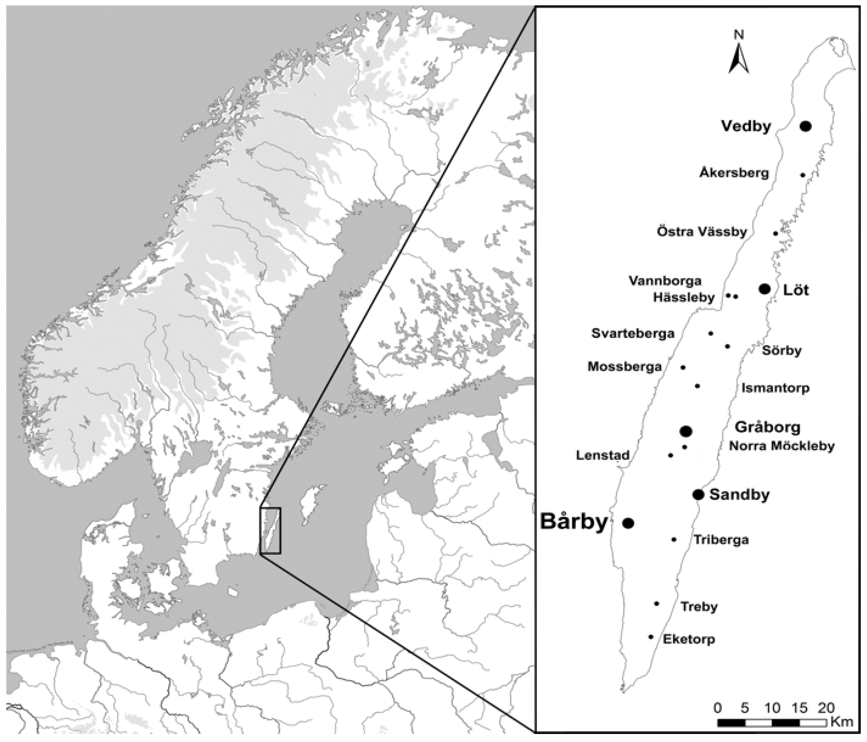
The island of Öland, situated east of the Swedish mainland, is home to several large ringforts dated to approximately AD 300–700 (Figure 1). Eighteen ringforts are currently known from historical maps and sources, but only 15 are still visible in the landscape today.
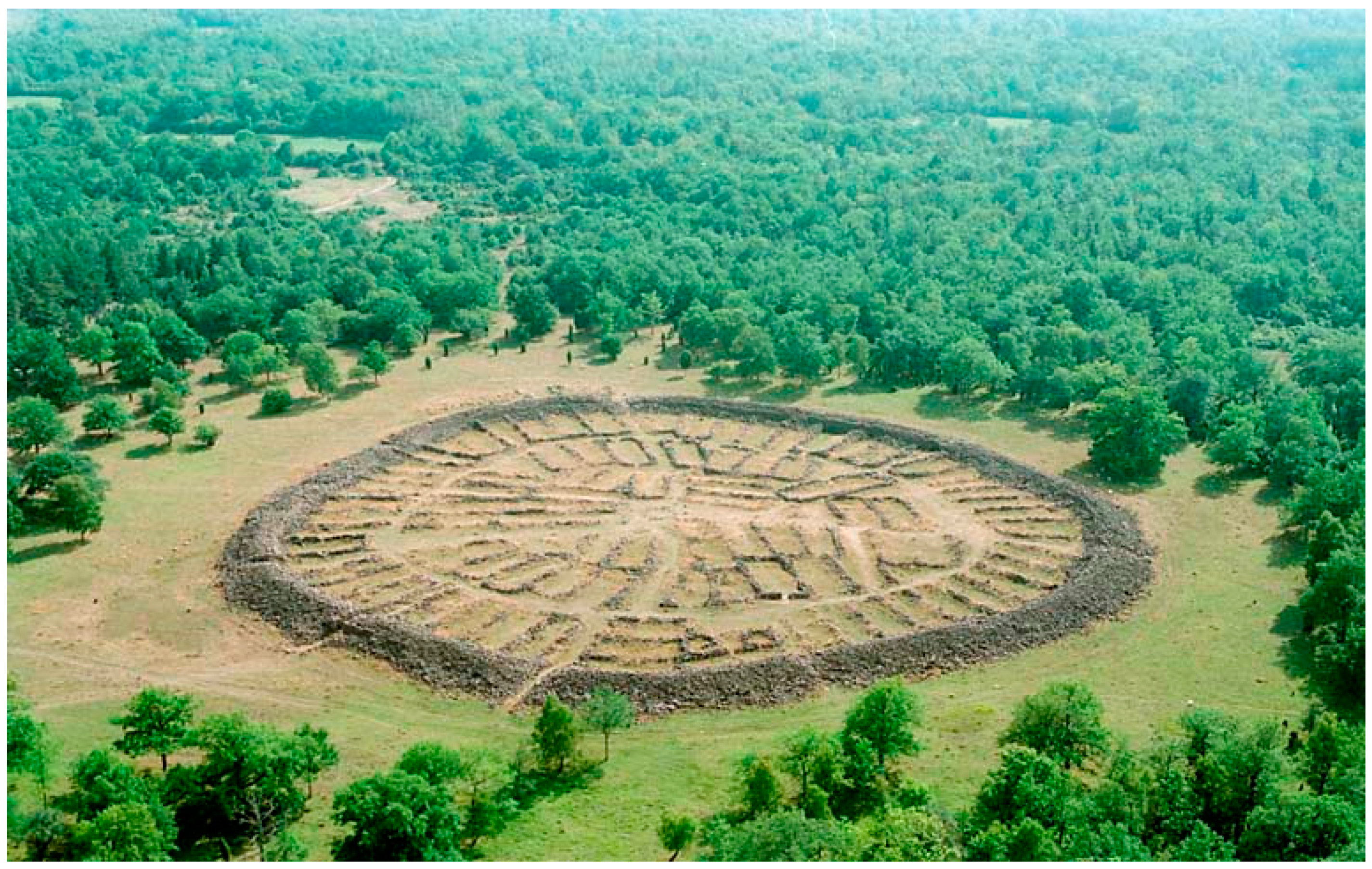
The best-preserved fort on the island is Ismantorp which contains the remains of approximately 95 stone foundations of houses still visible inside the fort’s perimeter wall [1,2] (Figure 2). Additional smaller archaeological inventories and excavations have confirmed the presence of similar stone house foundations in at least 10 other forts on the island [3,4].
Given that the Ölandic forts are very large, any archaeological excavations within them are bound to be both expensive and time consuming. This has led to a situation where only limited archaeological excavations have been carried out over the last 40 years. One example is the fort at Löt in north-eastern Öland, where three square metres have been excavated in a fort measuring over 1.6 ha in size [5]. Needless to say, it is difficult to provide any accurate interpretations based on such a limited source material. As a consequence, and in order to properly understand how and why the forts were constructed, other ways of investigating these structures are needed.
To provide new insights into past activities within the large Ölandic ringforts, geophysical investigations were suggested as a suitable starting point. The non-destructive character of geophysical surveys and their ability to cover large areas within a reasonable timeframe were important factors when deciding on a way forward.
Therefore, the project “The Big Five” was initiated in 2014 (see Reference [6]). The project, funded by the Swedish Research Council and the Swedish Academy of Letters, History and Antiquities, aimed at using multi-channel ground-penetrating radar (GPR) instruments to investigate several large Ölandic ringforts. The purpose of the surveys was to assess the preservation of archaeological remains within the forts as well as the effect of past and extensive agricultural activities. The surveys also aimed at locating house foundations and internal house features (e.g., postholes, hearths) within the forts. If spatial plans could be created, it would provide a valuable empirical foundation for future archaeological research and targeted excavations.
Previous geophysical surveys, conducted in one of the smaller forts on Öland, Sandby borg, in 2010, indicated that GPR would be a suitable geophysical method for the detection of such archaeological features (see Figure 3) [7], and yearly excavations have highlighted the benefits of geophysical surveys as the starting point and foundation for archaeological research within the Ölandic forts [8].
Multi-channel array surveys have subsequently been carried out in four large Ölandic forts: Bårby, Löt, Vedby and Gråborg [10,11]. Single-channel GPR surveys have also been carried out at the smaller forts Triberga and Hässleby borg. This article focuses on presenting the data collected at Bårby borg on western Öland.
2. Archaeological Background
2.1. The Ölandic Forts
Many of the Ölandic forts were constructed around AD 300, and it has been suggested that the models for the forts should be found within the Roman cultural sphere [1,12,13,14,15]. Some researchers have suggested that the forts were used mainly as a refuge in times of war [12,16], while others have suggested that they should be interpreted as fortified villages [9] or as occasional training areas for warriors [1,2].
However, the possibility to understand the purpose of the forts is limited, as only one of them has been completely excavated. This fort, Eketorp, was investigated in 1964–1974, and it was shown that the fort had been used in three different phases (ca. AD 300–1240) [9]. The fort was interpreted as a refuge in the first phase, and as a fortified village in the second phase, with 53 stone foundations of houses, similar to the ones visible at Ismantorp. During its third phase, the layout of the settlement changed to radially placed rows of houses around an open square in the centre (Figure 10a). The findings from the third medieval phase, such as weapons, armour and many findings related to horseback riding and cavalry activities, indicate that the fort was being used as a military encampment [17] (p. 15) [18].
The activities at Eketorp were thus changing over time and this highlights the problem with assuming that all Ölandic forts were used in a similar manner or constructed for the same purpose. Even though many of the forts look similar from a constructional point of view, they have probably not been used in the same way. This is best exemplified by comparing the forts Ismantorp and the second phase at Eketorp. Even though the forts were constructed during the same time period and share a very similar spatial layout, they were most likely not used in a similar way. Eketorp shows evidence of being continuously populated leaving thick cultural layers and lots of artefacts behind. Ismantorp, on the other hand, has very thin cultural layers and very few artefacts. It is therefore likely that the forts were used in different ways and that the purpose of one fort, exemplified by the varying activities at Eketorp, actually could change over time.
2.2. Bårby Borg
Bårby borg, the island’s only semi-circular fort, is situated on the west coast of Öland at the edge of an approximately 20 m high limestone ridge (Swedish: Landborgen) (Figure 4a). The shallow limestone bedrock is covered with thin gravel deposits underneath the cultural layers within the fort. It is the smallest fort included in the project with an inner area of approximately 7500 m2. The inner area of the fort is enclosed by a partly demolished stone wall, approximately 11–13 m wide and 2–3.5 m high (Swedish registry of ancient monuments), and a roughly 3 m wide opening in the eastern part of the wall marks the entrance to the fort. The inner area of the fort was farmed up until the mid-1900s and has since been owned and cared for by the Swedish National Heritage Board (RAÄ) and, from 2015, the National Property Board of Sweden (Statens fastighetsverk).
One small excavation was carried out in 1930 by Swedish archaeologist Mårten Stenberger (Figure 4b). The excavations produced indications of cultural deposits (but no finds or well-preserved structures), and subsequent field walking surveys revealed artefacts belonging to two different chronological phases: One Migration period/early Vendel period phase (ca. AD 375–700), exemplified by the discovery of a golden solidus coin dating to AD 518–527 (Justin I), and one Medieval phase (most likely dated to the 14th century), exemplified by the discovery of a rowel belonging to a late medieval spur [12]. During the Middle Ages, the fort seems to have been partly rebuilt. Traces of mortar in the gate show that it was rebuilt to a vaulted gate tower, probably similar to the still preserved medieval gate tower at Gråborg. Additionally, according to antiquarian sources from the 17th and early 19th centuries, the semi-circular stone wall was surrounded by a smaller outer wall partly built by brick. This wall is no longer visible on the site [12] (pp. 222–224).
In 1930, the landowner of the Bårby fort regularly ploughed the interior and noted that the south-eastern area of the fort seemed to contain large quantities of animal bones, fire cracked rock and larger stones, and Stenberger suggested that the larger stones might be the remains of Iron Age houses [19]. After Stenberger finished his excavations, he suggested that additional investigations should be carried out within the fort as soon as possible [20].
Nothing further would be done inside the fort, however, until 82 years later, in 2012, when a metal detector survey was carried out [21,22] (p. 68). The metal detector survey further strengthened the chronology suggested by Stenberger and clearly showed that this is a settlement used over a long period of time and that it should be expected to find both Iron Age and Medieval settlement traces within the fort (if preserved). It is, however, worth noting that only two of the 37 finds collected during the metal detection could be dated, with any certainty, to prehistoric times. One of these prehistoric finds was a small part of an Iron Age brooch dated to the Migration period [21]. The medieval finds included, for example, an iron spur and a ring brooch [21].
The explicit purpose of the geophysical surveys at Bårby was therefore to investigate if any preserved houses and internal house features, both Iron Age and Medieval, could be detected within the fort and if the spatial plan of the two possible phases could be established. An additional purpose was to evaluate the effect of the intense agricultural activities within the fort.
3. Method
GPR instruments were first tested for archaeological purposes in 1974 [23] and have since become an ever-popular method for archaeological prospection (e.g., [24,25,26,27]). The first archaeological GPR surveys in Sweden were conducted in 1979 [28], but it was not until the mid-2000s that GPR became a more frequently used tool for Swedish archaeological investigations. For a more comprehensive discussion on the development of archaeological geophysics in Sweden see Reference [29].
The method utilises electromagnetic pulses emitted into the ground from a transmitting antenna. The time, in nanoseconds, needed for a pulse to travel from the antenna, into the soil (to a reflective structure) and back to a receiving antenna is measured. Such reflective structures could be, for example, stones, the bedrock, the ground-water table, archaeological features or soil boundaries. If the velocity of the radar wave can be estimated, the depth to encountered objects or boundaries can be calculated (see References [24,26] for an in-depth introduction to GPR and explanations of, for example, the relationship between the radar signal and reflections from different subsurface materials).
For the geophysical surveys at Bårby, a MALÅ Imaging Radar Array (MIRA) GPR system was used. This is a multi-channel GPR system containing nine transmitting and eight receiving antenna elements with a centre frequency of 400 MHz. Multi-channel array GPR surveys, like this were first tested outside the cathedral in Uppsala in 2005 [30], and subsequent surveys targeted high-profile archaeological sites in central and southern Sweden (and abroad) from 2008 onwards with very convincing results [31,32,33,34,35,36].
The antennas were placed in a box with a crossline channel spacing of 8 cm. This box was pushed over the survey area using a small garden tractor (Figure 5). Each survey swath (i.e., every line surveyed with the instrument) resulted in 16 individual radar reflection profiles. Subsequently, a 1.36 m wide swath could be surveyed in a single pass, making it a highly efficient tool for large-scale archaeological geophysical surveys. Under favourable circumstances, the instrument can survey several hectares of data every day. In the case of the Bårby survey, the entire inner area of the fort was covered in approximately 3 h (including the set-up time) with an inline and crossline sampling spacing of 8 cm. During the survey, the instrument was connected to a Trimble R6 (RTK-GPS) providing positioning information to the instrument with a couple of centimetres in accuracy.
The data were subsequently processed using the MALÅ RSlicer software and the applied filters included Subtract DC-Shift, Time Zero Adjustment, AGC Gain, Antenna Ringdown Correction, Bandpass Filter, Migration and Hilbert Transform (envelope). The velocity of the radar wave for the time-to-depth conversion was estimated to 0.12 m/ns using the hyperbola fitting function and the migration test tool of the software. Data were then exported as GeoTiffs (both with and without the Hilbert transform) and imported into ArcMap 10.4.1 for archaeological interpretation. Interpretation of the GPR data was carried out according to the workflow proposed by Poscetti [37]. Stripy noise patterns, visible in the depth slices (e.g., Figure 6), are partly caused by old ploughing marks and partly by unwanted stripy artefacts created during the data collection. These were, unfortunately, not possible to remove completely during the post-processing of the data.
4. Results and Interpretation
4.1. Iron Age Bårby
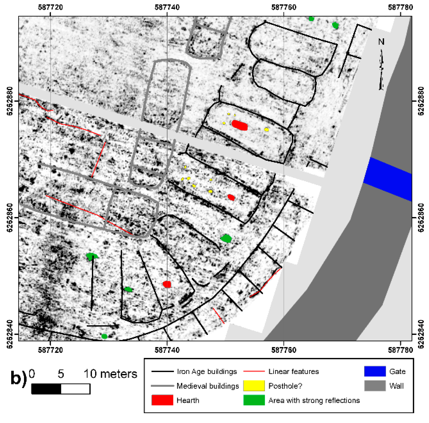
The results of the GPR survey clearly show the foundations of several well-preserved houses (Figure 6, Figure 7, Figure 8 and Figure 9). The clearest results were collected in the south-eastern part of the fort, previously identified as a possible location for well-preserved Iron Age houses [19]. This area contains a distinct cluster of buildings extending radially from the perimeter wall towards the fort’s central parts (Figure 6). This “outer block” seems to be flanked by a small gap (road/street?) and then another similar radial cluster of houses follows (“middle block”). A couple of extremely well preserved structures, situated in the northern central part of the fort (Figure 7, Figure 8 and Figure 9), indicate that the first two sets of radially aligned houses are followed by a separate central “inner block” of houses placed in a straight line (see Figure 9 for an overview of the structures encountered within the fort).
The length of the houses in the outer block could not be accurately measured, as the points where they would connect to the outer perimeter wall are outside the survey area. This area is unsuitable for GPR surveys, as it contains lots of debris from the surrounding wall and the demolished buildings. However, an estimation would indicate that the length of the houses in the outer block, as measured up to the hypothetical inner part of the perimeter wall, range between 8–12 m. The width of these buildings most commonly range between 4.5–5.5 m. The gap dividing the outer and the middle house blocks is between 2–6 m wide and seems to be wider in the eastern areas of the fort, near the entrance, only to become narrower in the northern and southern parts of the fort. It is clearest in the south-eastern area of the fort.
The houses in the middle block are slightly bigger and some of them measure 15–16 m in length and 5–6 m in width. One exceptionally clear house in the area just inside the entrance to the fort also produces clear reflections from an oval shaped pit (approximately 2.8 × 1 m) in the middle of the house. These strong reflections are most likely caused by a so-called “long hearth”, situated in the middle of the house (see Figure 6). It is most likely visible thanks to a highly reflective fill, and its location in the middle of the house speaks in favour of this being a hearth. Similar sized hearths have previously been documented in other parts of Sweden and abroad and are commonly situated in the middle of Iron Age longhouses (e.g., [38,39]).
The results in this area are also so clear that the gables and doorways of many buildings can be accurately mapped. Several other buildings in this block also have possible internal hearths and other anomalies that may be interpreted as postholes. The thickness of the common walls among the houses in the different blocks ranges from 0.8–1.1 m.
The presence of a detached inner block of houses is indicated by two buildings in the northern central parts of the fort (see Figure 7 and Figure 8). The two buildings share the same central stone wall and measure between 13.7–14.6 m in length and 5.3–6.1 m in width. The northernmost house is the clearest, displaying lots of reflections from internal features, most likely caused by a combination of postholes, a possible circular hearth/pit (even though the size of the feature may speak against this being a hearth) and, further down, by limestone slabs marking the floor level of the house. The possible postholes within the house (and other houses in the fort) are most likely visible because of probable stone linings which makes them more reflective and, thus, easier to detect with GPR. The sheer density of the reflections inside the houses indicates that there are also large amounts of rubble present making interpretation and identification of, for example, individual postholes difficult. The southernmost house also seems to be divided into two equal sections by a highly reflecting structure (Figure 8). Whether this should be interpreted as a room divider or as a pit feature is not possible to say, but similar dividers are visible in some of the houses in the northernmost part of the fort (see linear features in Figure 9). Similar linear features are also present in the Eketorp fort (see Reference [40] (p. 65)). Here, the linear features are the remnants of an earlier perimeter wall. A similar interpretation for the Bårby dividers would be interesting but needs to be supplemented by further archaeological evidence. These two houses were probably not the only buildings in the central block, and it is likely that several more houses followed in a similar pattern extending the block towards the south. Later ground disturbances mean that these buildings cannot be clearly distinguished anymore; partial traces of them do exist but not enough to estimate their size or the full extent of the central block itself.
The spatial plan of the many houses, together with their size and shape, indicate that all of these buildings are likely to have an Iron Age origin. They, for example, share a similar spatial layout as houses identified at Eketorp II and Sandby borg (Figure 3) which would indicate a migration period date. This is also in line with the previous field walking and metal detection finds from 1930 and 2012 [20,21,22]. Both Eketorp II and Sandby borg also contain the remains of a detached central block of houses.
4.2. Medieval Bårby
The stray finds collected by Stenberger in 1930s and the metal detection from 2012 (see examples in Section 3 above) also indicate a medieval phase of the fort. This phase is also visible in the geophysical data with four longer buildings of a different type having been identified. These buildings seem to be placed in a U-shape, enclosing an open square in the central westernmost part of the fort. Two of the houses are placed with their long axis in a north–south direction, and a northern and southern house, with their long axes in the east–west direction, complete the U-shape (see medieval buildings in Figure 9). The full extent of the northernmost house (house M1) cannot be estimated using GPR data only but presumably extends well beyond 22 m in length before disappearing towards the edge of the cliff. House M1 has a measured width of almost 8 m and seems to be divided into several compartments or squares (exemplified by what seems to be linear, highly reflecting structures within the probable medieval houses). These might mark groundsills or partition walls similar to the ones encountered in Eketorp III (e.g., Reference [9] (p. 170)). The same applies for house M2 (see Figure 6) which has similar compartments. The house is 22.7 m long and 5.8 m wide. House M3 is of almost exactly the same length as house M2 (22.5 m) but slightly wider (6.5 m). The southernmost house (house M4) is as equally wide as house M1 (8 m) and is clearly distinguishable for approximately 23 m but could very well extend further, as faint traces of a possible continuation are visible in the data. Areas with strong reflections may indicate the location of hearths within house M1 and M2.
The open area in the middle measures approximately 1145 m2 and forms an open square facing the edge of the cliff in the west. It is worth noting that the empty trench excavated by Stenberger [12] in the 1930s was located in this central open area of the medieval phase, and the geophysical data thus support the idea that this is in fact an area without any significant structures present. Any remains of Iron Age houses, which probably existed in the central part of the fort, were most likely destroyed during the construction of the medieval buildings.
5. Discussion
Many clearly defined buildings have been discovered within the fort. Not only are the outlines of these buildings clear, but lots of internal features (i.e., postholes and hearths) are also visible, allowing accurate estimations of their width, length, distance among roof-bearing posts, location of hearths, etc.
Approximately 50 Iron Age buildings are visible in the data, but the fort would most likely have contained several more. If we assume that the mean width of houses forming the outer block is 5 m, it would be possible to fit approximately 39 dwellings in this block (including a gap for the entrance). Similarly, the middle block (mean width of 5.5 m) would consist of approximately 27 houses. Finally, the central block (with a mean width of 5.7 m) could contain approximately 15 houses, assuming that it would have consisted of a full row of buildings. In total, the fort would then have contained 81 houses during the Iron Age (if they were all in use at the same time). The actual number would most likely be slightly less than this if one is to include possible roads and streets among some of the houses. A careful estimation of the total number of houses would then result in 70–75 which is in accordance with previous estimations by Fallgren [3,4]. Evidence of centrally placed hearths may help to differentiate residential buildings from other structures, although a centrally placed hearth could also be an indication of the location of a so-called hall building, built mainly for ceremonial purposes, which may have existed within the fort (see for example References [41,42,43]).
The migration period phase at Bårby shares many similarities with the forts Eketorp II, Sandby borg and other ringforts such as Ismantorp (e.g., [1,8,9]). The buildings all have similar lengths and widths and are placed in a similar pattern within the “defences”. It is, however, not possible to say anything certain about the purpose of the fort just by looking at the geophysical data alone. A similar spatial layout of the buildings does not necessarily mean that the fort has been used for the same purpose. As mentioned above, this is best exemplified by comparing Eketorp II and Ismantorp, two forts that share a similar spatial layout but have been utilized in different ways (see discussion in Reference [15]). The Ismantorp fort, unlike the Eketorp fort, was never used as a fortified village with prolonged habitation.
The estimated thickness of the cultural layers at Bårby ranges between 0.35 and 0.7 m and, with the many finds discovered during the field walking and metal detecting, the fort seems to have more in common with the Eketorp site. It is still unclear whether the cultural deposits were accumulated mostly during the Iron Age or the Medieval phase. The predominance of medieval finds from the metal detecting are, on their own, not an indication of a more intense activity during this time, as the medieval remains would be located closer to the surface and, as such, would be more affected by the continuous ploughing of the area. But Iron Age Bårby should most likely be interpreted as a place of refuge in times of war or as a more permanent fortified village.
The four proposed medieval buildings within the fort are similarly very clear. It is, however, notable that these houses do not share a similar general spatial layout with the medieval Eketorp III phase, and the Bårby houses are generally wider than their Eketorp counterparts. It is also notable that the proposed medieval houses at Bårby have slightly curved gables. Such curved gables are common in the Iron Age, but they are also known from more recent buildings on the island, especially outbuildings. This is different from medieval Eketorp where the houses have straight gables and are placed in a radial pattern extending from the perimeter wall towards the middle of the fort (see Figure 10a). It has been suggested previously, as mentioned above, that the Eketorp III settlement was a possible military garrison (e.g., [17,18]). Although the houses actually belonging to the medieval period at Bårby have much in common with the buildings at Eketorp III, the overall distribution location of the houses within the fort seems to have more in common with the spatial layout of farms in the historically known regulated villages on Öland with farm buildings enclosing an open square (see Figure 10b). Consequently, from the layout of the settlement, it is plausible to interpret medieval Bårby as a large fortified farm or estate, rather than as a military encampment such as Eketorp III.
In order to obtain the extra information necessary for making more precise interpretations regarding the purpose of Bårby borg, the geophysical data need to be supplemented by targeted archaeological excavations. This is also necessary in the areas where the two suggested settlement phases overlap, and the geophysical data are unclear. Excavations are also quite urgently needed near the edge of the cliff as this is an area affected by erosion.
6. Conclusions
The purpose of the geophysical surveys at Bårby was to investigate if any preserved houses with internal features could be detected within the fort and whether the spatial plan of the fort could be established. An additional objective was also to evaluate the effect of the intense agricultural activities within the fort.
The results clearly show the remains of approximately 50 Iron Age houses in different degrees of preservation. The houses appear to be very similar to those found at Sandby borg and Eketorp II. The number of houses was most likely much higher and careful estimations based on the size of the encountered buildings point to a number exceeding 75. The high resolution data also provide clear evidence of internal house features, such as post holes and hearths, in some of the buildings, and the fort was most likely used as a place of refuge in times of war or as a more permanent fortified village, similar to the completely excavated second phase at the Eketorp fort.
The data also seem to contain evidence of four medieval houses situated in the central part of the fort. These buildings were constructed in a similar way to those encountered during the final medieval phase at Eketorp but were placed in a different fashion within the fort and with slightly curved gables. Targeted excavations are needed in order to determine if the medieval phase of Bårby should be regarded as a fortified large farm, a military encampment, like Eketorp III, or as something else. Salvage excavations may also be necessary near the edge of the cliff, as this area is affected by erosion. If nothing is done, the well-preserved houses of both Iron Age and Medieval date are at risk of being lost forever.
The results also exemplify the benefits of using large-scale, non-intrusive geophysical surveys for estimating the current state of preservation of archaeological structures buried below the ground. Even though agricultural activities have affected the buried remains at Bårby, the fort is still relatively well preserved if compared with the fort at Gråborg where most of the in situ archaeological structures have been destroyed by intense farming.
In order to better understand the purpose of the Ölandic forts, more empirical data are required. Motorized GPR surveys are a quick and reliable way of gaining such data—data that will provide information on the activities taking place within the forts. The results will hopefully serve as a catalyst for many future archaeological investigations.
Author Contributions
Conceptualization: A.V. and A.A.; methodology, A.V. and C.G.; validation, A.V., C.G. and A.A.; formal analysis, A.V.; investigation, A.V. and C.G.; resources, A.V.; data curation, A.V. and C.G.; writing—Original draft preparation, A.V.; writing—Review and editing, A.V., C.G. and A.A.; visualization, A.V. and C.G.; supervision, A.A.; project administration, A.V.; funding acquisition, A.V. All authors have read and agreed to the published version of the manuscript.
Funding
This research was funded by the Swedish Research Council, grant number 2013-01468.
Acknowledgments
We would like to thank the Swedish Research Council for financial support. Thanks also to Kerstin Lidén, Karl-Oskar Erlandsson, Robert Danielsson, Börje Karlsson, Sven Kalmring, Vasily Kharitonov and the Swedish National Heritage Board for survey permissions. A special thanks to Jimmy Adcock and to four anonymous reviewers for their thoughtful responses that helped improve the manuscript.
Conflicts of Interest
The authors declare no conflict of interest.
References
- Andrén, A. A world of stone. Warrior culture, hybridity, and Old Norse cosmology. In Old Norse Religion in Long-Term Perspectives. Origins, Changes, Interactions; Andrén, A., Jennbert, K., Raudvere, C., Eds.; Nordic Academic Press: Lund, Sweden, 2006; Volume 8. [Google Scholar]
- Andrén, A. Tracing old Norse cosmology. In The World Tree, Middle Earth and the Sun in Archaeological Perspectives; Nordic Academic Press: Lund, Sweden, 2014; pp. 1–247. [Google Scholar]
- Fallgren, J.H. Fornborgar, bebyggelse och odlingslandskap. In Gråborg på Öland. Om en borg, ett Kapell och en by; Tegnér, G., Ed.; Kungliga Vitterhets Historie och Antikvitets Akademien: Stockholm, Sweden, 2008; pp. 1–223. [Google Scholar]
- Fallgren, J.H. The Ölandic ring-forts and the Iron Age Medieval agricultural landscape. In Ringwälle und Verwandte Strukturen Des Ersten Jahrtausends n. Chr. an Nord-Und Ostsee; Ferring Stiftung; Segschneider, M., Ed.; Wacholtz: Neumünster, Germany, 2009; pp. 27–49. [Google Scholar]
- Schultze, H. Tre Kvadratmeter i Löts Fornborg. Fornlämning RAÄ 29, “Trindborgen”, Valsnäs 13:1, Löts sn, Borgholms kn, Öland. Arkeologisk Provundersökning 1989 och 1990; Kalmar Läns Museum: Kalmar, Sweden, 2006. [Google Scholar]
- Viberg, A. The big five. Mapping the subsurface of Iron Age forts on the island of Öland Sweden. Archaeol. Pol. 2015, 53, 521–525. [Google Scholar]
- Viberg, A.; Victor, H.; Fischer, S.; Lidén, K.; Andrén, A. The ringfort by the sea: Archaeological geophysical prospection and excavations at Sandby borg (Öland). Archäologisches Korrespondenzblatt 2014, 44, 413–428. [Google Scholar]
- Victor, H. Sandby borg-ett fruset ögonblick under folkvandringstid. In Grävda Minnen. Från Skedemosse Till Sandby Borg; Arnell, K.-H., Papmehl-Dufay, L., Eds.; Kalmar Läns Museum: Kalmar, Sweden, 2015; pp. 97–115. [Google Scholar]
- Borg, K.; Näsman, U.; Wegraeus, E. Eketorp. Fortification and settlement on Öland/Sweden. The Monument; Royal Academy of Letters History and Antiquities: Stockholm, Sweden, 1976. [Google Scholar]
- Viberg, A.; Larson, M. Mobile laser scanning and 360° photography for the documentation of the Iron Age ringfort Gråborg, Öland, Sweden. Archaeol. Pol. 2015, 53, 396–399. [Google Scholar]
- Viberg, A.; Gustafsson, C.; Burks, J. On the interpretation of geophysical data and the suggested presence of a western moat at Gråborg on Öland. Fornvännen 2017, 112, 1–9. [Google Scholar]
- Stenberger, M. Öland under Äldre Järnåldern. En Bebyggelsehistorisk Undersökning. Ph.D. Thesis, Kungl. Vitterhets, Historie och Antikvitets Akademien, Uppsala University, Uppsala, Stockholm, Sweden, 1933; pp. 1–305. [Google Scholar]
- Werner, J. Zu den auf Öland und Gotland gefundenen byzantinischen Goldmünzen. Fornvännen 1949, 44, 257–286. [Google Scholar]
- Herschend, F. Fällgallerporten i Eketorp II, Öland. Tor 1985, 20, 165–216. [Google Scholar]
- Näsman, U. The Gates of Eketorp. To the Question of Roman Prototypes of the Öland Ring-forts. In The Birth of Europe. Archaeology and Social Development in the First Millennium A. D.; Randsborg, K., Ed.; Analecta Romana Instituti Danici: Rome, Italy, 1989; pp. 129–139. [Google Scholar]
- Stenberger, M. En preliminär undersökning av Ismantorps borg. Fornvännen 1925, 20, 358–375. [Google Scholar]
- Edgren, B.; Herschend, F. Eketorp. The Fortified Village on the Island of Öland; Swedish National Heritage Board: Stockholm, Sweden, 1985. [Google Scholar]
- Borg, K. Eketorp-III. Den Medeltida Befästningen på Öland. Artefakterna; Royal Academy of Letters History and Antiquities: Stockholm, Sweden, 1998. [Google Scholar]
- Stenberger, M. Report 1082; Antikvarisk-topografiska arkivet; Swedish National Heritage Board and the Royal Swedish Academy of Letters, History and Antiquities: Stockholm, Sweden, 1930. [Google Scholar]
- Stenberger, M. Report 4793; Antikvarisk-topografiska arkivet; Swedish National Heritage Board and the Royal Swedish Academy of Letters, History and Antiquities: Stockholm, Sweden, 1930. [Google Scholar]
- Paulsson, J. Arkeologisk förundersökning. Södra Bårby 26:1 > 1, fornlämning Mörbylånga 17:1, Mörbylånga socken. In Rapport Skattskyddsprojektet 2012; Kalmar Län: Mörbylånga Kommun, Öland, Sweden, 2012. [Google Scholar]
- Erlandsson, K.-O. Nya inblickar i några Öländska fornborgar. In Grävda Minnen. Från Skedemosse Till Sandby Borg; Arnell, K.-H., Papmehl-Dufay, L., Eds.; Kalmar Läns Museum: Kalmar, Sweden, 2015; pp. 61–71. [Google Scholar]
- Vickers, R.S.; Dolphin, L.T. A communication on an archaeological radar experiment at Chaco canyon, New Mexico. MASCA Newsl. 1975, 11, 6–8. [Google Scholar]
- Daniels, D. Ground-Penetrating Radar; Institution of Electrical Engineers: London, UK, 2007. [Google Scholar]
- Conyers, L.B. Interpreting Ground-Penetrating Radar for Archaeology; Left Coast Press Inc.: Walnut Creek, CA, USA, 2012. [Google Scholar]
- Conyers, L.B. Ground-Penetrating Radar for Archaeology; Altamira Press: Lanham, MD, USA, 2013. [Google Scholar]
- Goodman, D.; Piro, S. GPR Remote Sensing in Archaeology, Geotechnologies and the Environment; Springer: Berlin/Heidelberg, Germany, 2013. [Google Scholar]
- Wihlborg, A.; Romberg, T. Georadar för att spåra fornlämningar? Meta 1980, 4, 33. [Google Scholar]
- Viberg, A.; Trinks, I.; Lidén, K. A review of the use of geophysical archaeological prospection in Sweden. Archaeol. Prospect. 2011, 18, 43–56. [Google Scholar] [CrossRef]
- Gustafsson, J.; Alkarp, M. Array GPR investigation of the cathedral of Uppsala. Near Surf. Geophys. 2007, 5, 203–207. [Google Scholar] [CrossRef]
- Trinks, I.; Johansson, B.; Gustafsson, J.; Emilsson, J.; Friborg, J.; Gustafsson, C.; Nissen, J.; Hinterleitner, A. Efficient, Large-scale Archaeological Prospection using a True Three-dimensional Ground-penetrating Radar Array System. Archaeol. Prospect. 2010, 17, 175–186. [Google Scholar] [CrossRef]
- Biwall, A.; Gabler, M.; Hinterleitner, A.; Karlsson, P.; Kucera, M.; Larsson, L.; Löcker, K.; Nau, E.; Neubauer, W.; Scherzer, D.; et al. Large Scale archaeological prospection of the Iron and Viking Age site Uppåkra in Sweden. First results of the LBI ArchPro landscape archaeological case study. In Archaeological Prospection. Extended Abstracts, Proceedings of the 9th International Conference on Archaeological Prospection, Izmir, Turkey, 19–24 September 2011; Drahor, M.G., Berge, M.A., Eds.; Archaeology and Art Publications: Izmir, Turkey, 2011; pp. 218–222. [Google Scholar]
- Trinks, I.; Biwall, A. Arkeologisk Prospektering av Fornlämningsmiljön Gamla Uppsala; Rapport UV-teknik; Riksantikvarieämbetet: Hägersten, Sweden, 2011. [Google Scholar]
- Trinks, I.; Neubauer, W.; Nau, E.; Gabler, M.; Wallner, M.; Hinterleitner, A.; Biwall, A.; Doneus, A.; Pregesbauer, M. Archaeological Prospection of the UNESCO World Heritage Site Birka Hovgården. In Archaeological Prospection. Proceedings of the 10th International Conference on Archaeological Prospection, Vienna, Austria, 29 May–2 June 2013; Neubauer, W., Trinks, I., Salisbury, R.B., Einwögerer, C., Eds.; Austrian Academy of Sciences Press: Vienna, Austria, 2013; pp. 39–40. [Google Scholar]
- Larsson, L.; Trinks, I.; Söderberg, B.; Gabler, M.; Dell ‘Unto, N.; Neubauer, W.; Ahlström, T. Interdisciplinary archaeological prospection, excavation and 3D documentation exemplified through the investigation of a burial at the Iron Age settlement site of Uppåkra in Sweden. Archaeol. Prospect. 2015, 22, 143–156. [Google Scholar] [CrossRef]
- Trinks, I.; Hinterleitner, A.; Neubauer, W.; Nau, E.; Löcker, K.; Wallner, M.; Gabler, M.; Filzwieser, R.; Wilding, J.; Schiel, H.; et al. Large-area high-resolution ground-penetrating radar measurements for archaeological prospection. Archaeol. Prospect. 2018, 25, 171–195. [Google Scholar] [CrossRef]
- Poscetti, V. Interpreting GPR data in GIS: Animation tools and 3D Visualization applied to the Archaeological Interpretation of Roman Structures. In Archaeological Prospection, Proceedings of the 10th International Conference on Archaeological Prospection, Vienna, Austria, 29 May–2 June 2013; Neubauer, W., Trinks, I., Salisbury, R.B., Einwögerer, C., Eds.; Austrian Academy of Sciences Press: Vienna, Austria, 2013; pp. 433–435. [Google Scholar]
- Edblom, L. Långhus i Gene: Teori och Praktik i Rekonstruktion. Ph.D. Thesis, Umeå University, Umeå, Sweden, 2004. [Google Scholar]
- Schietzel, K.; Bau, F.; Hammon, H.; Schüller, J. Spurensuche Haithabu-Archäologische Spurensuche in der Frühmittelalterlichen Ansiedlung Haithabu: Dokumentation und Chronik 1963–2013; Wachholtz: Neumünster/Hamburg, Germany, 2014. [Google Scholar]
- Weber, K. The Ring-wall around Eketorp I. In Eketorp. Fortification and Settlement on Öland/Sweden; Borg, K., Näsman, U., Wegraeus, E., Eds.; Royal Academy of Letters History and Antiquities: Stockholm, Sweden, 1976. [Google Scholar]
- Herschend, F. The origin of the hall in southern Scandinavia. Tor 1993, 25, 175–199. [Google Scholar]
- Carstens, L. Powerful space. The Iron-Age hall and its development during the Viking Age. In Viking Worlds: Things, Spaces and Movement; Eriksen, M.H., Pedersen, U., Rundberget, B., Axelsen, I., Berg, H.L., Eds.; Oxbow Books: Oxford, UK, 2014. [Google Scholar]
- Rundkvist, M.; Viberg, A. Geophysical investigations on the Viking period platform mound at Aska in Hagebyhöga Parish, Sweden. Archaeol. Prospect. 2015, 22, 131–138. [Google Scholar] [CrossRef]
Figure 1.
Map of the island of Öland and the location of its ringforts.

Figure 2.
The Ölandic fort Ismantorp with well-preserved Iron Age building foundations. Photo: J. Norrman (1997), ©RAÄ.
Figure 2.
The Ölandic fort Ismantorp with well-preserved Iron Age building foundations. Photo: J. Norrman (1997), ©RAÄ.

Figure 3.
(a) GPR results from Sandby borg. (b) Interpretation of the GPR results from Sandby borg showing multiple Iron Age house foundations within the fort (results and interpretations presented in Reference [7]). (c) Spatial layout of the already excavated Ölandic ringfort Eketorp II [9].

Figure 4.
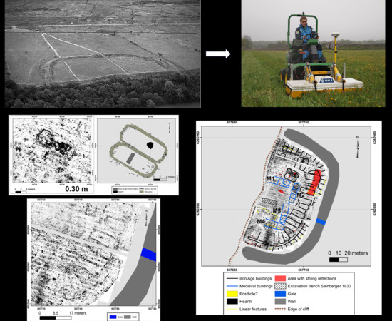
(a) Aerial photo of Bårby borg (Photo by: J. Norrman (1992), ©RAÄ). (b) Map showing the spatial layout of Bårby borg and the location of the excavation trench from 1930. Coordinates in Sweref99 TM.
Figure 4.
(a) Aerial photo of Bårby borg (Photo by: J. Norrman (1992), ©RAÄ). (b) Map showing the spatial layout of Bårby borg and the location of the excavation trench from 1930. Coordinates in Sweref99 TM.


Figure 5.
The 16 channel 400 MHz MALÅ Imaging Radar Array (MIRA) measuring outside Gråborg ringfort, Öland. Photo: M. Larsson (2014).
Figure 5.
The 16 channel 400 MHz MALÅ Imaging Radar Array (MIRA) measuring outside Gråborg ringfort, Öland. Photo: M. Larsson (2014).

Figure 6.
(a) GPR results from the south-eastern part of the fort showing probable Iron Age and Medieval buildings (depth slice at 0.2–0.3 m below ground). Image is showing the envelope of the GPR trace (strong reflections depicted in black). (b) Schematic interpretation of the different houses in the GPR data along with prominent internal house features. Coordinates in Sweref99 TM.


Figure 7.
GPR depth slices (0.28–0.66 m below ground surface) showing (at least) two parallel Iron-Age buildings in the central northern parts of the fort. Coordinates in Sweref99 TM.
Figure 7.
GPR depth slices (0.28–0.66 m below ground surface) showing (at least) two parallel Iron-Age buildings in the central northern parts of the fort. Coordinates in Sweref99 TM.

Figure 8.
(a) GPR depth slice (approximately 30 cm below the surface) depicting the two parallel Iron Age buildings in the central northern part of the fort. (b) Schematic interpretation of the two parallel Iron Age buildings and their most prominent internal features. Coordinates in Sweref99 TM.
Figure 8.
(a) GPR depth slice (approximately 30 cm below the surface) depicting the two parallel Iron Age buildings in the central northern part of the fort. (b) Schematic interpretation of the two parallel Iron Age buildings and their most prominent internal features. Coordinates in Sweref99 TM.

Figure 9.
Schematic interpretation of features identified with GPR inside the Bårby fort. The perimeter wall, the location of the gate and the edge of the steep cliff in the west are marked for reference. Coordinates in Sweref99 TM.
Figure 9.
Schematic interpretation of features identified with GPR inside the Bårby fort. The perimeter wall, the location of the gate and the edge of the steep cliff in the west are marked for reference. Coordinates in Sweref99 TM.

Figure 10.
(a) Spatial layout of the medieval Eketorp phase [18] (p. 23). (b) Aerial photograph of four farms at Gösslunda, Öland. Photo: J. Norrman (1992), ©RAÄ.
Figure 10.
(a) Spatial layout of the medieval Eketorp phase [18] (p. 23). (b) Aerial photograph of four farms at Gösslunda, Öland. Photo: J. Norrman (1992), ©RAÄ.

© 2020 by the authors. Licensee MDPI, Basel, Switzerland. This article is an open access article distributed under the terms and conditions of the Creative Commons Attribution (CC BY) license (http://creativecommons.org/licenses/by/4.0/).
Share and Cite
MDPI and ACS Style
Viberg, A.; Gustafsson, C.; Andrén, A. Multi-Channel Ground-Penetrating Radar Array Surveys of the Iron Age and Medieval Ringfort Bårby on the Island of Öland, Sweden. Remote Sens. 2020, 12, 227. https://doi.org/10.3390/rs12020227
AMA Style
Viberg A, Gustafsson C, Andrén A. Multi-Channel Ground-Penetrating Radar Array Surveys of the Iron Age and Medieval Ringfort Bårby on the Island of Öland, Sweden. Remote Sensing. 2020; 12(2):227. https://doi.org/10.3390/rs12020227
Chicago/Turabian StyleViberg, Andreas, Christer Gustafsson, and Anders Andrén. 2020. "Multi-Channel Ground-Penetrating Radar Array Surveys of the Iron Age and Medieval Ringfort Bårby on the Island of Öland, Sweden" Remote Sensing 12, no. 2: 227. https://doi.org/10.3390/rs12020227
Note that from the first issue of 2016, this journal uses article numbers instead of page numbers. See further details here.