
Monitoring of Damages to Cultural Heritage across Europe Using Remote Sensing and Earth Observation: Assessment of Scientific and Grey Literature


Abstract
:
1. Introduction
1.1. State of the Art on the RS of Satellite Imagery for Monitoring Hazards and Damages to CH
1.2. Background on Previous Literature Assessments, including Findings, Recommendations, and Limits

| Publication | Main Topic | Time Range | Geographic Area | Outcomes |
|---|---|---|---|---|
| [7] | Remote sensing in archaeology | 1999–2015 | Europe | 1. Substantial increase in RS for archaeology. 2. Need for common repository to share knowledge. |
| [12] | SAR for cultural heritage | 1985–2016 | World | 1. SAR as an increasingly accessible and practical technique for monitoring multiple threats. |
| [13] | InSAR data for hazard assessment on UNESCO WHS | 2000–2017 | Europe | 1. InSAR increasingly used in Europe with a large number of data for heritage stakeholders. 2. Necessity for more public consultation exercises and workshops and user engagement at early stages of InSAR implementation. |
| [4] | Looting of archaeological sites | 2000–2017 | World | 1. Substantial body of different satellite image-based processing methods. 2. Lack of common practices, the need for more dissemination and user uptake. |
| [6] | Air/spaceborne imagery for cultural heritage | 1907–2017 | World | 1. Different RS image techniques for different applications. 2. Increase in access to archive and novel data |
| [5] | Google Earth application for cultural heritage | 2005–2016 | World | 1. Google Earth as a basic, efficient, and open-access tool for cultural heritage monitoring. |
| [14] | Machine intelligence approaches to archaeological remote sensing | 1995–2017 | World | 1. Data sharing and collaboration between different disciplines. 2. Need for machine intelligence applications for processing datasets and replicating complex calculations. |
| [11] | SAR and InSAR for cultural heritage | 1992–2020 | World | 1. Combining all radar technologies. 2. Multidisciplinary collaboration is crucial. 3. Including frontier information technologies to better manage data that radar technologies can provide. |
| [10] | Most endangered types of cultural heritage | 1969–2021 | World | 1. Substantial discrepancy between damage documented and damage studied. |
- A necessity to pay more attention to matching the properties of current and future satellites with the needs and questions of archaeological research and built-heritage conservation practice.
- A necessity to raise awareness among the multiple stakeholders revolving around the wider field of heritage on the range of uses of available satellites via more investments in training and capacity building.
- A necessity to expand and share the available datasets to widen the types of analyses that can be undertaken.
- A slow increase (albeit still underdeveloped) in the level of engagement of non-experts in remote sensing [11];
- The development of international capacity building and training projects, as confirmed by numerous international initiatives run on a global level, such as Space2place [15] or EO4GEO [16]; or in Europe, such as JPI-CH Prothego [17,18]; in the Mediterranean and Near East, such as EAMENA [19,20] and EDUU [21]; and in Central Asia, with the CAAL project [22];
- The launch of new (or the improvement in existing) satellite imagery archive platforms such as the Sentinel-Hub (https://www.sentinel-hub.com/, accessed on 12 April 2023) or USGS (https://earthexplorer.usgs.gov/, accessed on 13 April 2023) ones.
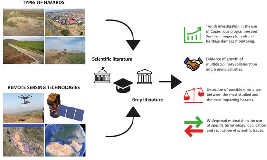
- A lack of a clear reconstruction of the trends in the study of hazards and resulting damage to cultural heritage encompassing both scientific research and Grey literature.
- A lack of a concise understanding of the RS methods and tools that can be used for each type of hazard.
2. Research Aims, Materials, and Method
2.1. Research Questions
- What are the types of hazards to cultural heritage that have been studied using satellite imagery so far?
- Are all the types of hazards equally addressed?
- Is there a correlation between a specific type of damage and satellite-based technology?
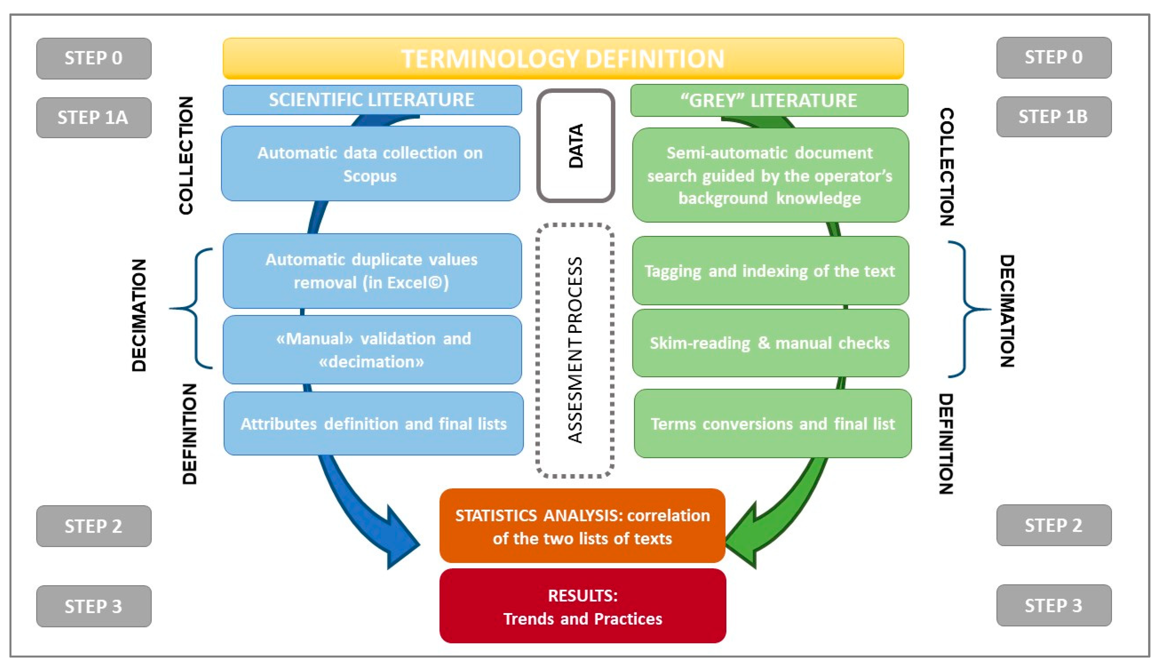
2.2. Methodology
- a.
- To investigate the scientific literature that is a testimony not only to the base research but often to the applied research activities conducted during projects or pilot demonstrative initiatives;
- b.
- To consider the Grey literature, i.e., materials and research produced and published in the form of reports, guidelines and white papers outside of the traditional academic publishing and distribution channels, catalogues, and repositories.
- –
- Step 0: Terminology definition;
- –
- Step 1: Data collection and literature assessment, divided into Steps 1A and 1B;
- –
- Step 2: Correlation of the two literature assessments;
- –
- Step 3: Analysis of findings regarding trends and best practices.
2.2.1. Terminology Definition
2.2.2. Literature Assessment
- •
- Step 1: Data collection and literature assessment of scientific and Grey Literature
- •
- Step 1A: Indexed literature assessment. (collection, decimation, definition)
- –
- “satellite” AND “heritage” AND “archaeology” AND “hazard”
- –
- “satellite” AND “heritage” AND “archaeology” AND “disaster”
- –
- “satellite” AND “heritage” AND “archaeology” AND “threat”
- –
- “satellite” AND “heritage” AND “archaeology” AND “risk”
- –
- “satellite” AND “heritage” AND “archaeology” AND “damage”
- –
- “satellite” AND “heritage” AND “archaeology” AND “destruction”
- –
- Such combinations produced a total of 1966 relevant articles.
- •
- Step 1B: “Grey” literature assessment (collection, decimation, definition)
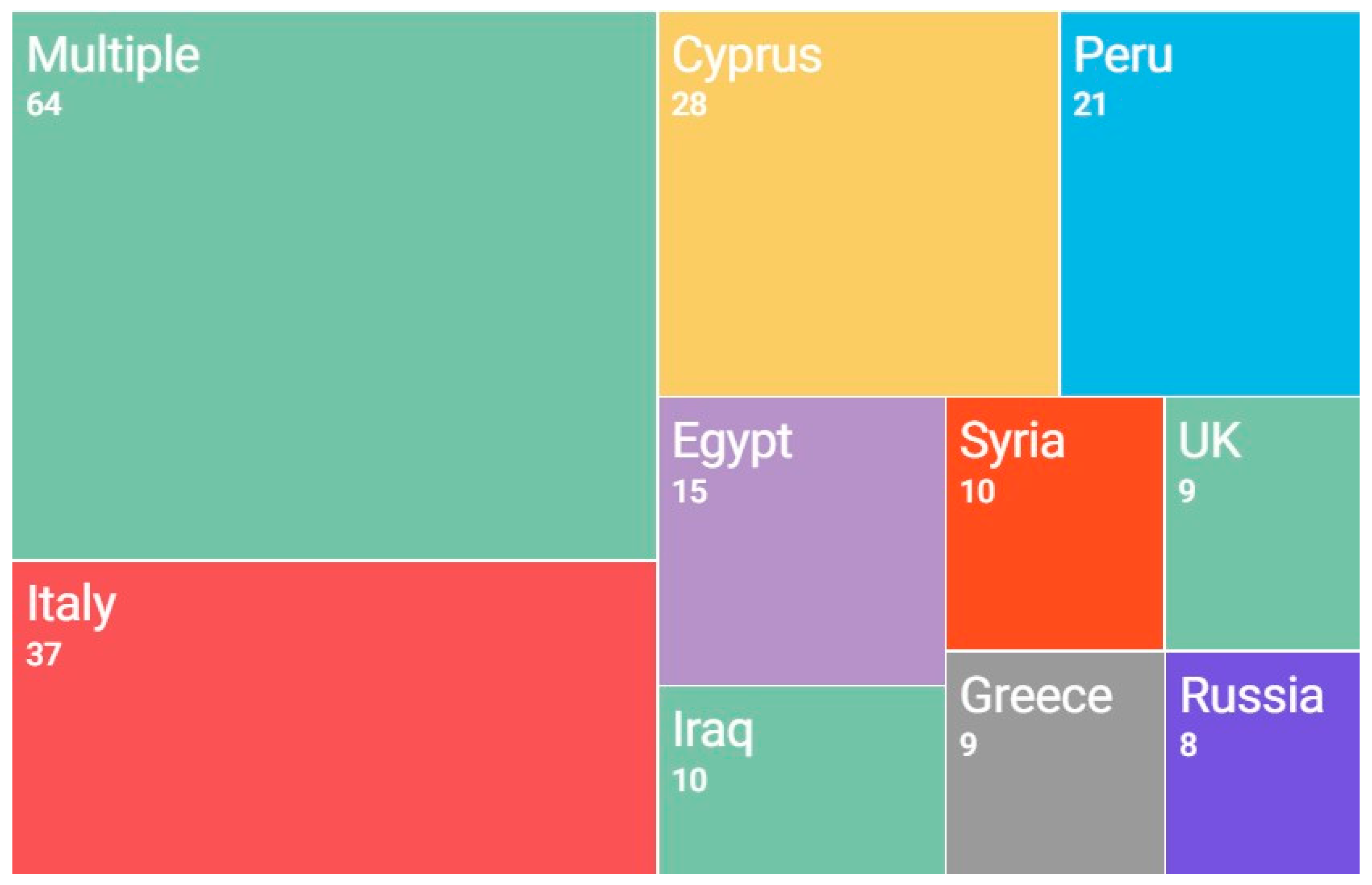
2.3. Geographic Framework of the Sample Selection
3. Results
3.1. Results of the Literature Assessment
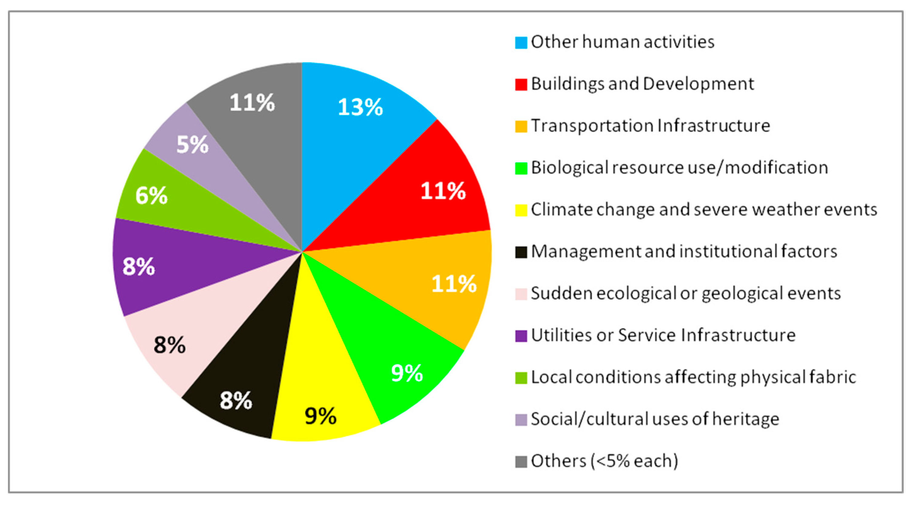
3.1.1. Overview of the Types of Damages Considered: Unbalanced Concentration on Specific Types of Hazards and Regionalisms
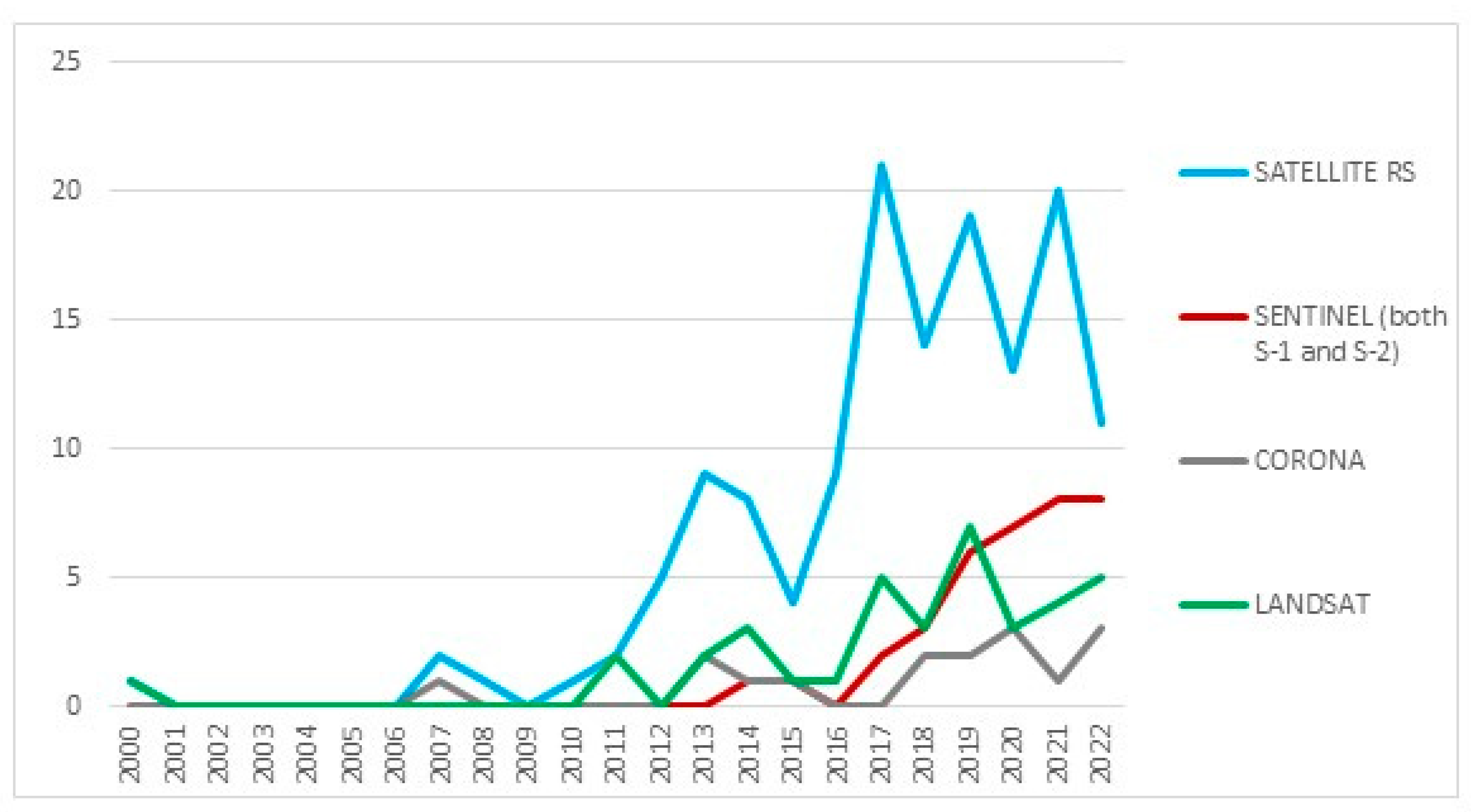
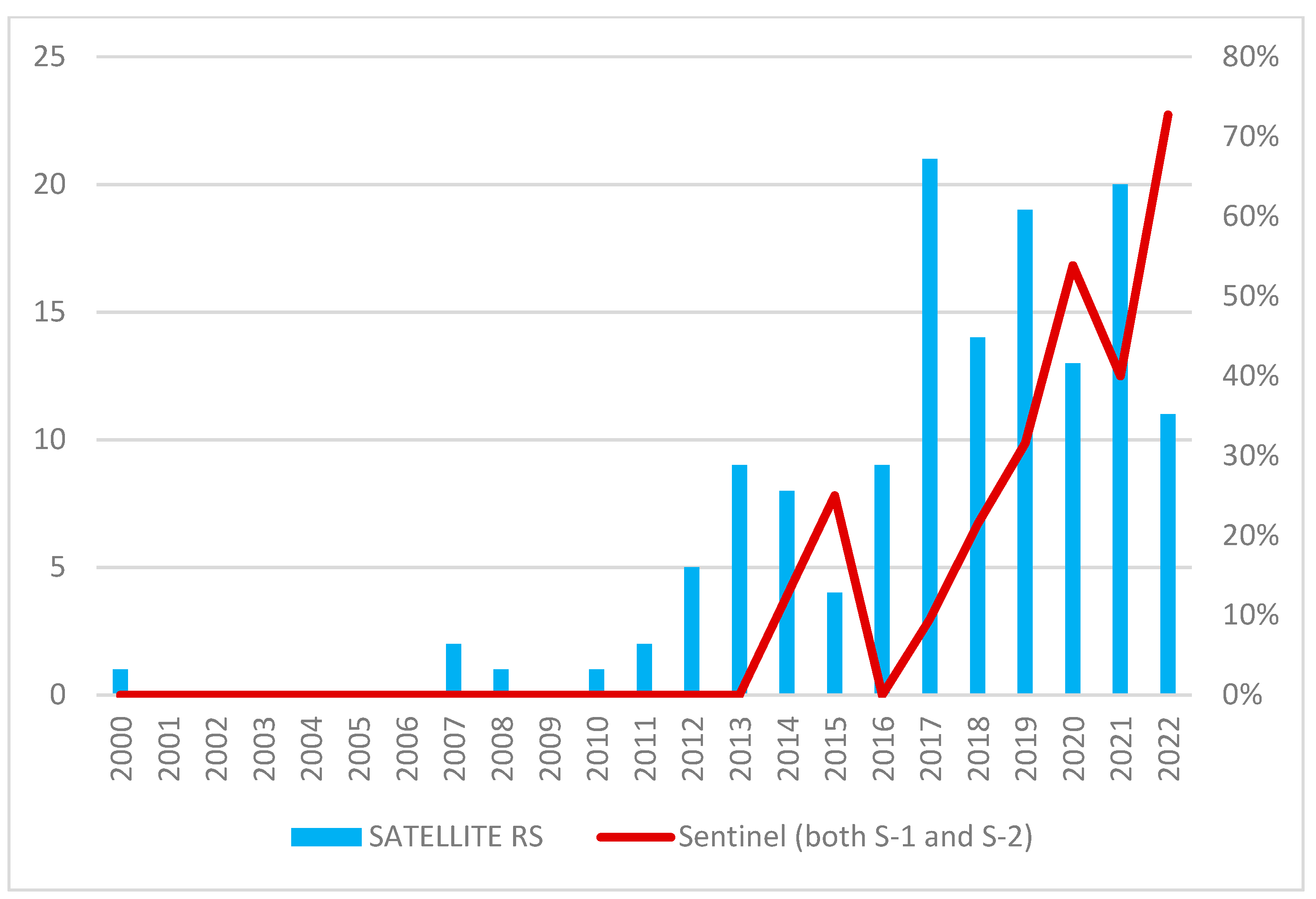
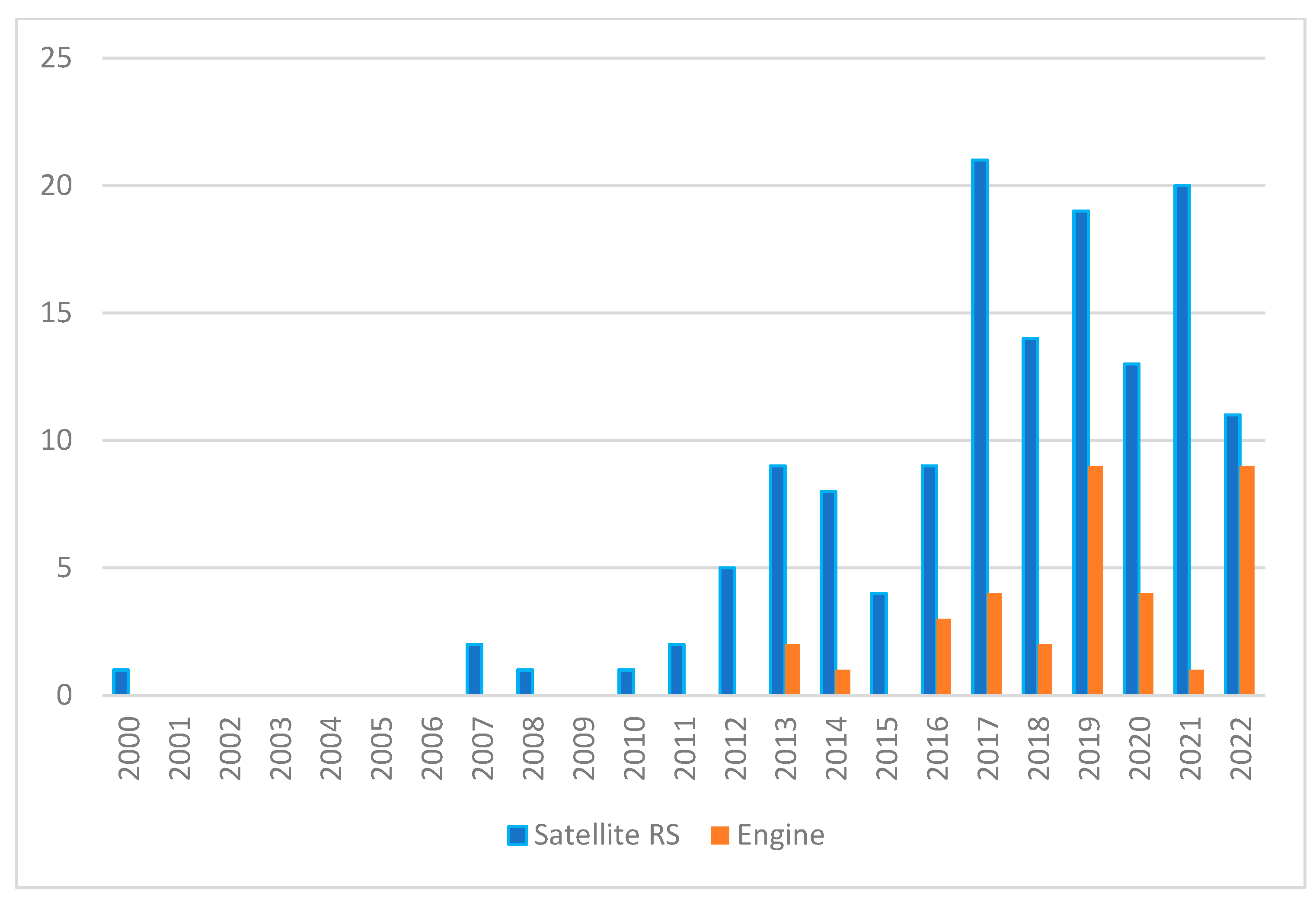
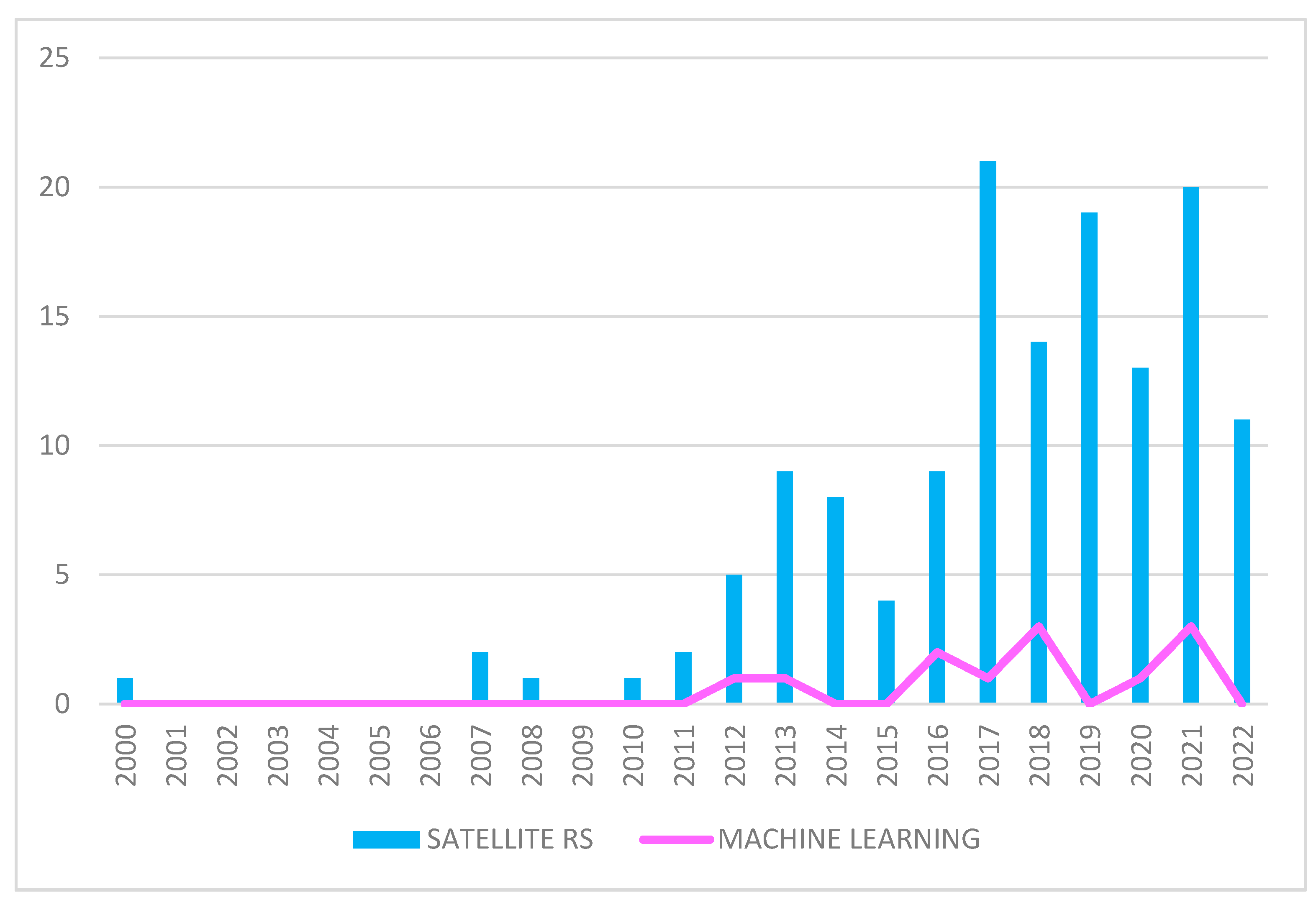
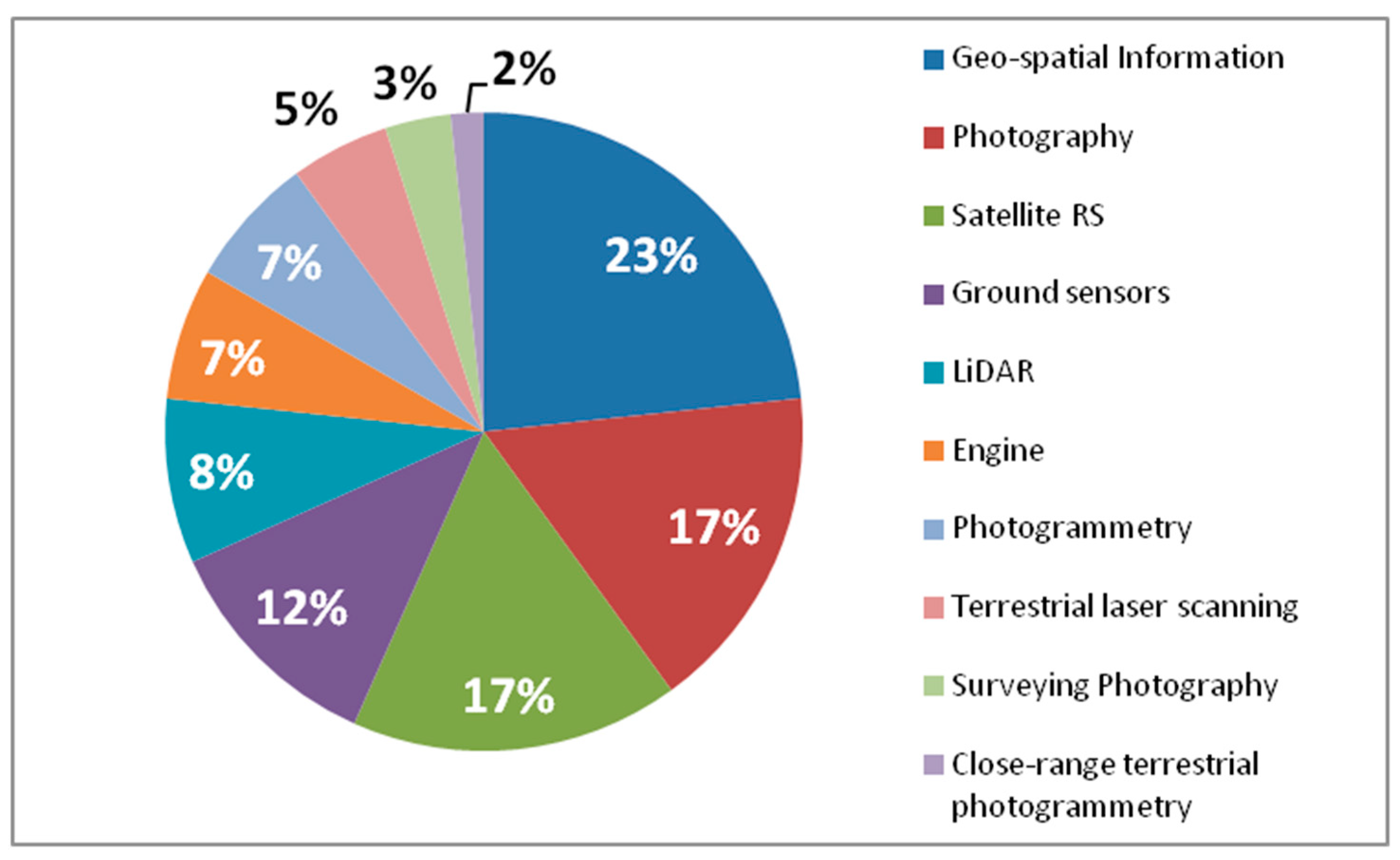
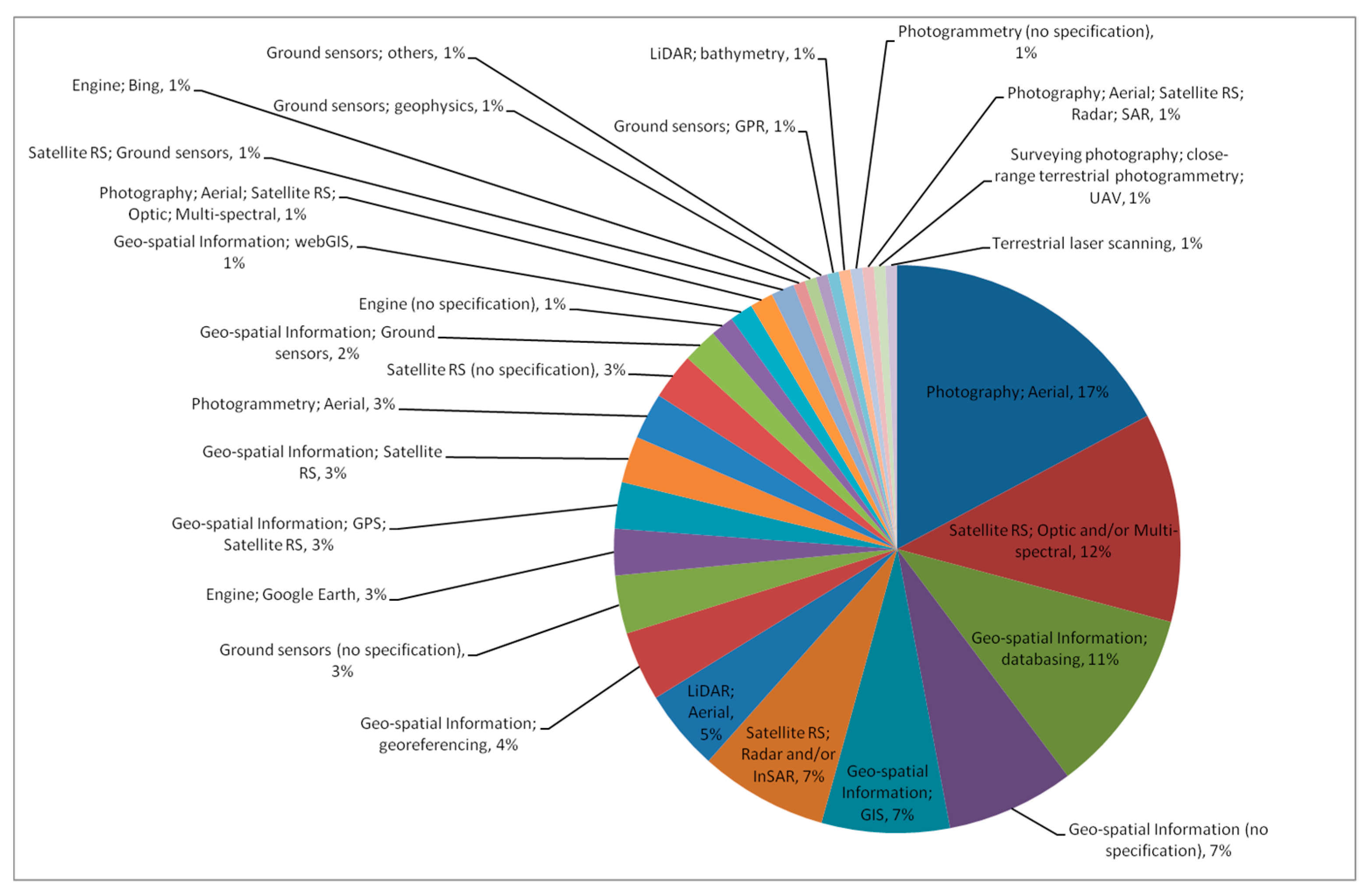
3.1.2. Overview of Technology Use in the Scientific Literature, Focusing on the Articles Relying on Satellite Remote Sensing
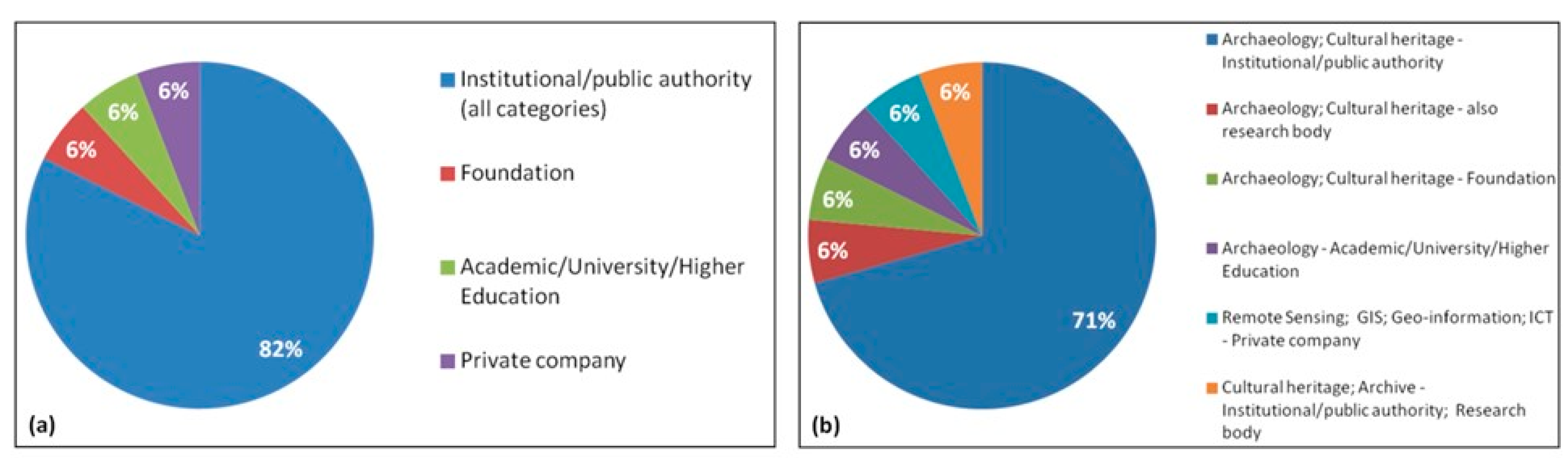
3.1.3. Grey Literature
- Authors’ expertise, as inferred from the “affiliation’s discipline”, i.e., the main field of the department/institution/organization/body that the authors are affiliated with. In the absence of personal information about the specific expertise of each individual author that could be known exclusively from their curriculum vitae (which was not available for this research and, however, is beyond the remit of the present study), we could only rely on the reasonable assumption that those who compiled the analyzed documents had expertise fitting with the main field of their organizations and/or that the described activities implied that the authors had the needed expertise (or a matching one). Therefore, with appropriate care, the affiliation’s discipline can be used as a proxy. The classes found include archaeology, cultural heritage, remote sensing, GIS, geo-information, information and communication technology (ICT), and archive, with the latter meaning building, curation, and management of archives.
- Role/mission/function/type of authors’ affiliation/organization as per their official statutory duties. The classes found include institutional/public authority, research body, foundation, academic/university/higher education, and private company.
4. Discussion of the Results Analysis: First Findings on Trends and Best Practices
4.1. Main Findings for the Scientific Literature Sample
4.2. Main Findings for the Grey Literature Sample
4.2.1. Aerial Photography: Commonalities and Regionalisms
4.2.2. Satellite Remote Sensing
4.2.3. Trends in Heritage Practice
5. Conclusions
Supplementary Materials
Author Contributions
Funding
Data Availability Statement
Conflicts of Interest
Appendix A
| UNESCO Factors |
|---|
| Buildings and development |
| Transport infrastructure |
| Utilities or service infrastructure |
| Pollution |
| Biological resource use/modification |
| Physical resource extraction |
| Local conditions affecting physical fabric |
| Social/cultural uses of heritage |
| Other human activities |
| Climate change and severe weather events |
| Sudden ecological or geological events |
| Invasive/alien species or hyper-abundant species Management and institutional factors |
| Other factors |
Appendix B
| Type of Heritage (Original Terms) | Type of Heritage (Conversion to UNESCO Categories) |
|---|---|
| Historic Environment | Sites |
| Cropmarks | Monuments |
| Earthworks | Monuments |
| Soil marks | Monuments |
| Structures | Groups of buildings |
| Buildings | Groups of buildings |
| Landscape | Landscape |
| Townscape | Sites |
| Coastal | Natural sites |
| Marine | Natural sites |
| Maritime | Natural sites |
| Extant features | Monuments |
| Relict features | Monuments |
| Rural | Natural sites |
| Shadow marks | Monuments |
| Underwater | Underwater monuments |
| Shallow waters | Geological and physiographical formations |
| Wetlands | Geological and physiographical formations |
| Industrial archaeology | Sites |
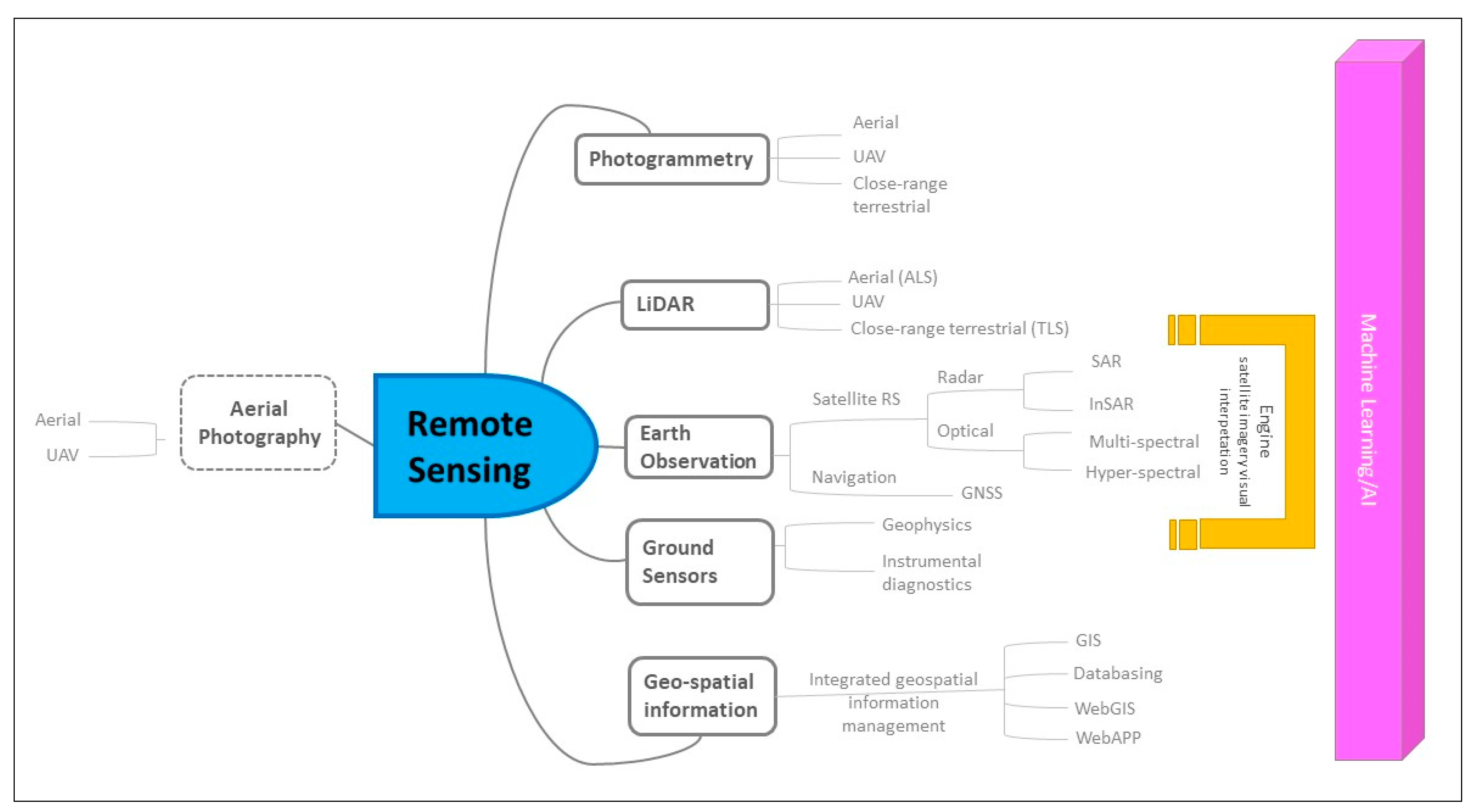
| Technology (Original Terms) | Technology (Conversion to Selected Lexicon, Including Sub-Categories) |
| Aerial photography | Photography; Aerial |
| GIS | Geo-spatial Information; GIS |
| Satellite imagery | Satellite RS; Optic; Radar |
| Low-altitude aerial photography | Photography; Aerial |
| Orthophotography | Photography; Aerial |
| Infrared imagery | Photography; Aerial; Satellite RS; Optic; Multi-spectral |
| Thermal imaging | Photography; Aerial; Satellite RS; Optic; Multi-spectral |
| Multispectral scanners | Photography; Aerial |
| Radar | Photography; Aerial; Satellite RS; Radar; SAR |
| Sonar (bathymetry) | Ground sensors; sonar (bathymetry) |
| Google Earth | Engine; Google Earth |
| Very Low-level Aerial Imagery | Photography; Aerial |
| Stereoscopic photography | Photography; Photogrammetry; Aerial |
| Lidar (aerial) | LiDAR; Aerial |
| Threats/Factors/Hazards (Original Terms) | Conversion to Primary Factors Affecting Properties (UNESCO Lexicon) |
| Development | Buildings and Development |
| Land-use change | Biological resource use/modification |
| Agriculture | Biological resource use/modification |
| Forestry activities | Biological resource use/modification |
| Scrub encroachment | Biological resource use/modification |
| Fisheries | Biological resource use/modification |
| Farming | Biological resource use/modification |
| Environmental change | Climate change and severe weather events |
| Limited resources | Management and institutional factors |
| Destruction | Other human activities |
| Minerals | Physical resource extraction |
| Peat extraction | Physical resource extraction |
| Coastal erosion | Sudden ecological or geological events |
References
- Agapiou, A.; Alexakis, D.D.; Lysandrou, V.; Sarris, A.; Cuca, B.; Themistocleous, K.; Hadjimitsis, D.G. Impact of Urban Sprawl to Cultural Heritage Monuments: The Case Study of Paphos Area in Cyprus. J. Cult. Herit. 2015, 16, 671–680. [Google Scholar] [CrossRef]
- Agapiou, A.; Lysandrou, V.; Hadjimitsis, D.G. Earth Observation Contribution to Cultural Heritage Disaster Risk Management: Case Study of Eastern Mediterranean Open Air Archaeological Monuments and Sites. Remote Sens. 2020, 12, 1330. [Google Scholar] [CrossRef] [Green Version]
- Agapiou, A. Multi-Temporal Change Detection Analysis of Vertical Sprawl over Limassol City Centre and Amathus Archaeological Site in Cyprus during 2015–2020 Using the Sentinel-1 Sensor and the Google Earth Engine Platform. Sensors 2021, 21, 1884. [Google Scholar] [CrossRef] [PubMed]
- Tapete, D.; Cigna, F. Detection of Archaeological Looting from Space: Methods, Achievements and Challenges. Remote Sens. 2019, 11, 2389. [Google Scholar] [CrossRef] [Green Version]
- Luo, L.; Wang, X.; Guo, H.; Lasaponara, R.; Shi, P.; Bachagha, N.; Li, L.; Yao, Y.; Masini, N.; Chen, F.; et al. Google Earth as a Powerful Tool for Archaeological and Cultural Heritage Applications: A Review. Remote Sens. 2018, 10, 1558. [Google Scholar] [CrossRef]
- Luo, L.; Wang, X.; Guo, H.; Lasaponara, R.; Zong, X.; Masini, N.; Wang, G.; Shi, P.; Khatteli, H.; Chen, F.; et al. Airborne and Spaceborne Remote Sensing for Archaeological and Cultural Heritage Applications: A Review of the Century (1907–2017). Remote Sens. Environ. 2019, 232, 111280. [Google Scholar] [CrossRef]
- Agapiou, A.; Lysandrou, V. Remote Sensing Archaeology: Tracking and Mapping Evolution in European Scientific Literature from 1999 to 2015. J. Archaeol. Sci. Rep. 2015, 4, 192–200. [Google Scholar] [CrossRef]
- Farace, D.; Frantzen, J. (Eds.) Sixth International Conference on Grey Literature; Grey Literature Network Service: Amsterdam, The Netherlands, 2005. [Google Scholar]
- Farace, D.; Frantzen, J. (Eds.) Twenty-Fourth International Conference on Grey Literature; Publishing Grey Literature in the Digital Century; Grey Literature Network Service: Amsterdam, The Netherlands, 2023. [Google Scholar]
- Zaina, F.; Cuca, B. Damages to Archaeological Heritage Recorded, Documented and Monitored Using Geospatial Technologies: An Assessment of Indexed Literature. In Proceedings of the 2022 IEEE Mediterranean and Middle-East Geoscience and Remote Sensing Symposium (M2GARSS), Virtual Symposium, 7–9 March 2022; pp. 110–113. [Google Scholar]
- Chen, F.; Guo, H.; Tapete, D.; Cigna, F.; Piro, S.; Lasaponara, R.; Masini, N. The Role of Imaging Radar in Cultural Heritage: From Technologies to Applications. Int. J. Appl. Earth Obs. Geoinf. 2022, 112, 102907. [Google Scholar] [CrossRef]
- Tapete, D.; Cigna, F. Trends and Perspectives of Space-Borne SAR Remote Sensing for Archaeological Landscape and Cultural Heritage Applications. J. Archaeol. Sci. Rep. 2017, 14, 716–726. [Google Scholar] [CrossRef] [Green Version]
- Tapete, D.; Cigna, F. InSAR Data for Geohazard Assessment in UNESCO World Heritage Sites: State-of-the-Art and Perspectives in the Copernicus Era. Int. J. Appl. Earth Obs. Geoinf. 2017, 63, 24–32. [Google Scholar] [CrossRef]
- Davis, D.S. Geographic Disparity in Machine Intelligence Approaches for Archaeological Remote Sensing Research. Remote Sens. 2020, 12, 921. [Google Scholar] [CrossRef] [Green Version]
- Matusch, T.; Schneibel, A.; Dannwolf, L.; Siegmund, A. Implementing a Modern E-Learning Strategy in an Interdisciplinary Environment—Empowering UNESCO Stakeholders to Use Earth Observation. Geosciences 2018, 8, 432. [Google Scholar] [CrossRef] [Green Version]
- Cipolloni, C.; Comerci, V.; Delfini, C.; Ferrigno, F.; Guerrieri, L.; Leoni, G.; Spizzichino, D.; Ventura, R. Remote Sensing Data for the Investigation of Geo-Hazard: EO4GEO Project and the Knowledge Sharing Challenges. In Proceedings of the IOP Conference Series: Earth and Environmental Science; Volume 509, 11th International Symposium on Digital Earth (ISDE 11) 24-27 September 2019, Florence, Italy; Nativi, S., Wang, C., Landgraf, G., Liberti, M.A., Mazzetti, P., Mohamed-Ghouse, Z.S., Eds.; IOP Publishing Ltd.: Bristol, UK. [CrossRef]
- Valagussa, A.; Frattini, P.; Crosta, G.; Spizzichino, D.; Leoni, G.; Margottini, C. Multi-Risk Analysis on European Cultural and Natural UNESCO Heritage Sites. Nat. Hazards 2021, 105, 2659–2676. [Google Scholar] [CrossRef]
- Themistocleous, K.; Cuca, B.; Agapiou, A.; Lysandrou, V.; Tzouvaras, M.; Hadjimitsis, D.G.; Kyriakides, P.; Kouhartsiouk, D.; Margottini, C.; Spizzichino, D.; et al. The Protection of Cultural Heritage Sites from Geo-Hazards: The PROTHEGO Project. In Proceedings of the Digital Heritage. Progress in Cultural Heritage: Documentation, Preservation, and Protection: 6th International Conference, EuroMed 2016, Nicosia, Cyprus, 31 October–5 November 2016; Ioannides, M., Fink, E., Moropoulou, A., Hagedorn-Saupe, M., Fresa, A., Liestøl, G., Rajcic, V., Grussenmeyer, P., Eds.; Springer International Publishing: New York, NY, USA, 2016; pp. 91–98. [Google Scholar]
- Zerbini, A. Developing a Heritage Database for the Middle East and North Africa. J. Field Archaeol. 2018, 43, S9–S18. [Google Scholar] [CrossRef] [Green Version]
- Bewley, R.; Wilson, A.; Kennedy, D.; Mattingly, D.; Banks, R.; Bishop, M.; Bradbury, J.; Cunliffe, E.; Fradley, M.; Jennings, R.; et al. Endangered Archaeology in the Middle East and North Africa: Introducing the EAMENA Project. In CAA2015. Keep the Revolution Going: Proceedings of the 43rd Annual Conference on Computer Applications and Quantitative Methods in Archaeology; Archaeopress Archaeology: Oxford, UK, 2016. [Google Scholar]
- Marchetti, N.; Curci, A.; Gatto, M.C.; Nicolini, S.; Mühl, S.; Zaina, F. A Multi-Scalar Approach for Assessing the Impact of Dams on the Cultural Heritage in the Middle East and North Africa. J. Cult. Herit. 2019, 37, 17–28. [Google Scholar] [CrossRef]
- Nebbia, M.; Cilio, F.; Bobomulloev, B. Spatial Risk Assessment and the Protection of Cultural Heritage in Southern Tajikistan. J. Cult. Herit. 2021, 49, 183–196. [Google Scholar] [CrossRef]
- Gomarasca, M.A. Basics of geomatics. Appl. Geomat. 2010, 2, 137–146. [Google Scholar] [CrossRef] [Green Version]
- UNESCO. Managing Disaster Risks; UNESCO: Paris, France, 2010. [Google Scholar]
- Agapiou, A.; Alexakis, D.D.; Sarris, A.; Hadjimitsis, D.G. Evaluating the Potentials of Sentinel-2 for Archaeological Perspective. Remote Sens. 2014, 6, 2176–2194. [Google Scholar] [CrossRef] [Green Version]
- Tapete, D.; Cigna, F.; Donoghue, D.N.M.; Philip, G. Mapping changes and damages in areas of conflict: From archive C-band SAR data to new HR X-band imagery, towards the sentinels. In Proceedings of the FRINGE Workshop 2015, Frascati, Italy, 23–27 March 2015; ESA SP, 2015, SP-731. European Space Agency: Rome, Italy, 2015. [Google Scholar]
- Elfadaly, A.; Lasaponara, R.; Murgante, B.; Qelichi, M.M. Cultural Heritage Management Using Analysis of Satellite Images and Advanced GIS Techniques at East Luxor, Egypt and Kangavar, Iran (A Comparison Case Study). In Proceedings of the Computational Science and Its Applications–ICCSA 2017: 17th International Conference, Trieste, Italy, 3–6 July 2017; Springer: Cham, Switzerland, 2017; Volume 10407. [Google Scholar] [CrossRef]
- Cuca, B.; Hadjimitsis, D.G. Space technology meets policy: An overview of Earth Observation sensors for monitoring of cultural landscapes within policy framework for Cultural Heritage. J. Archaeol. Sci. Rep. 2017, 14, 727–733. [Google Scholar] [CrossRef] [Green Version]
- Evans, S. Historic England Aerial Investigation & Mapping (Formerly National Mapping Programme) Standards Technical Review; Research Report Series no. 46-2019; Historic England, Fort Cumberland: Portsmouth, UK, 2019. [Google Scholar]
- Instituto Andaluz del Patrimonio Histórico. Recomendaciones Técnicas Para la Georreferenciación de Entidades Patrimoniales. Recomendaciones Técnicas. 06; Versión 1.3 07/10/2011; IAPH: Sevilla, Spain, 2011. [Google Scholar]
- National Emergency Risk Management Plan for Cultural Heritage; Ministerio de Cultura y Deporte—Gobierno de España. Available online: https://www.culturaydeporte.gob.es/planes-nacionales/textos.html (accessed on 5 January 2023).
- Historic Environment Scotland. Short Guide: Applied Digital Documentation in the Historic Environment, 1st ed.; Historic Environment Scotland: Scotland, UK, 2018. [Google Scholar]
- Lambrick, G. Air and Earth. Aerial Archaeology in Ireland. A Review for the Heritage Council; The Heritage Council: Dublin, Ireland, 2008. [Google Scholar]
- EASA. Easy Access Rules for Unmanned Aircraft Systems, Easa Erules: Aviation Rules for the 21st Century. 2022. Available online: https://www.easa.europa.eu/en/regulations (accessed on 21 April 2023).
- Ruciński, D.; Rączkowski, W.; Niedzielko, J. A Polish perspective on optical satellite data and methods for archaeological sites prospection. In Proceedings of the SPIE 9535, Third International Conference on Remote Sensing and Geoinformation of the Environment (RSCy2015), Paphos, Cyprus, 19 June 2015. [Google Scholar]
- Russo, A.; Della Giovampaola, I. Il monitoraggio e la manutenzione delle aree archeologiche. Il piano per il futuro del Parco archeologico del Colosseo. In Monitoraggio E Manutenzione Delle Aree Archeologiche. Cambiamenti Climatici, Dissesto Idrogeologico, Degrado Chimico-Ambientale; Russo, A., Della Giovampaola, I., Eds.; “L’Erma” di Bretschneider: Rome, Italy, 2020; pp. 13–18. [Google Scholar]
- Archeological Park of Colosseum. Parco Archeologico del Colosseo Duemilaventi—Duemilaventuno. Annual Report 2020–2021. Available online: https://parcocolosseo.it/annual-report/ (accessed on 5 January 2023).
- The European Parliament and of the Council. Directive (EU) 2019/1024 of the European Parliament and of the Council of 20 June 2019 on Open Data and the Re-Use of Public Sector Information (Recast); The European Parliament and of the Council: Brussels, Belgium, 2019. [Google Scholar]
- Sarris, A.; Papadopoulos, N.; Agapiou, A.; Salvi, M.C.; Hadjimitsis, D.G.; Parkinson, W.A.; Yerkes, R.W.; Gyucha, A.; Duffy, P.R. Integration of geophysical surveys, ground hyperspectral measurements, aerial and satellite imagery for archaeological prospection of prehistoric sites: The case study of Vésztő-Mágor Tell, Hungary. J. Archaeol. Sci. 2013, 40, 1454–1470. [Google Scholar] [CrossRef]
- Agapiou, A.; Alexakis, D.D.; Hadjimitsis, D.G. Spectral sensitivity of ALOS, ASTER, IKONOS, LANDSAT and SPOT satellite imagery intended for the detection of archaeological crop marks. Int. J. Digit. Earth 2014, 7, 351–372. [Google Scholar] [CrossRef]
- Themistocleous, K.; Hadjimitsis, D.G.; Georgopoulos, A.; Agapiou, A.; Alexakis, D.D. Development of a Low Altitude Airborne Imaging System for Supporting Remote Sensing and Photogrammetric Applications ‘The ICAROS Project’ Intended for Archaeological Applications in Cyprus. In Proceedings of the Progress in Cultural Heritage Preservation: 4th International Conference, EuroMed 2012, Limassol, Cyprus, 29 October–3 November 2012; Ioannides, M., Fritsch, D., Leissner, J., Davies, R., Remondino, F., Caffo, R., Eds.; Lecture Notes in Computer Science. Springer: Berlin/Heidelberg, Germany, 2012; Volume 7616. [Google Scholar] [CrossRef]
- Agapiou, A.; Alexakis, D.D.; Sarris, A.; Hadjimitsis, D.G. Orthogonal Equations of Multi-Spectral Satellite Imagery for the Identification of Un-Excavated Archaeological Sites. Remote Sens. 2013, 5, 6560–6586. [Google Scholar] [CrossRef] [Green Version]
- Agapiou, A.; Lysandrou, V.; Sarris, A.; Papadopoulos, N.; Hadjimitsis, D.G. Fusion of Satellite Multispectral Images Based on Ground-Penetrating Radar (GPR) Data for the Investigation of Buried Concealed Archaeological Remains. Geosciences 2017, 7, 40. [Google Scholar] [CrossRef] [Green Version]
- Cerra, D.; Gege, P.; Evagorou, E.; Agapiou, A.; de los Reyes, R. Monitoring Marine Areas from the International Space Station: The Case of the Submerged Harbor of Amathus, Digital Heritage. In Proceedings of the Digital Heritage. Progress in Cultural Heritage: Documentation, Preservation, and Protection: 8th International Conference, EuroMed 2020, Virtual Event, 2–5 November 2020; Revised Selected Papers. pp. 127–137. [Google Scholar] [CrossRef]
- Zaina, F. A Risk Assessment for Cultural Heritage in Southern Iraq: Framing Drivers, Threats and Actions Affecting Archaeological Sites. Conserv. Manag. Archaeol. Sites 2019, 21, 184–206. [Google Scholar] [CrossRef]
- Zaina, F.; Nabati Mazloumi, Y. A Multi-temporal Satellite-based Risk Analysis of Archaeological Sites in the Qazvin Region (Iran). Archaeol. Prospect. 2021, 28, 467–483. [Google Scholar] [CrossRef]
- Chyla, J.M. How can remote sensing help in detecting the threats to archaeological sites in upper Egypt? Geosciences 2017, 7, 97. [Google Scholar] [CrossRef] [Green Version]
- Tapete, D.; Cigna, F. COSMO-SkyMed SAR for detection and monitoring of archaeological and cultural heritage sites. Remote Sens. 2019, 11, 1326. [Google Scholar] [CrossRef] [Green Version]
- Rayne, L.; Gatto, M.C.; Abdulaati, L.; Al-Haddad, M.; Sterry, M.; Sheldrick, N.; Mattingly, D. Detecting change at archaeological sites in North Africa using open-source satellite imagery. Remote Sens. 2020, 12, 3694. [Google Scholar] [CrossRef]
- Archaeological Area and the Patriarchal Basilica of Aquileia. Unesco World Heritage List Area Archeologica Di Aquileia E Basilica Patriarcale; Piano Di Gestione; Area Archeologica Di Aquileia E Basilica Patriarcale: Aquileia, Italy, 2017; Available online: https://www.fondazioneaquileia.it/it/visita-aquileia/aquileia-patrimonio-unesco (accessed on 5 January 2023).
- Rączkowski, W. Integrating survey data—The Polish AZP and beyond. In Remote Sensing for Archaeological Heritage Management; Cowley, D.C., Ed.; EAC Occasional Paper No. 5, Occasional Publication of the Aerial Archaeology Research Group No. 3; Europae Archaeologia Consilium (EAC): Bruxelles, Belgium, 2010; pp. 153–160. [Google Scholar]
- Kobyliński, Z. Siedemdziesiàt lat Archeologii Lotniczej w Polsce, Âwiatowit 1; Światowit—Annual of the Institute of Archaeology of the University of Warsaw (nowa seria), fasc: Warszawa, Poland, 1999; Volume 1, pp. 112–122. [Google Scholar]
- Żuk, L.; Królewicz, S. Uses of Sentinel-1 and -2 Images in Heritage Management: A Case Study from Lednica Landscape Park (Poland). Geosciences 2022, 12, 159. [Google Scholar] [CrossRef]
- Casana, J.; Laugier, E.J. Satellite imagery-based monitoring of archaeological site damage in the Syrian civil war. PLoS ONE 2017, 12, e0188589. [Google Scholar] [CrossRef] [Green Version]
- Chen, F.; Lasaponara, R.; Masini, N. An overview of satellite synthetic aperture radar remote sensing in archaeology: From site detection to monitoring. J. Cult. Herit. 2017, 23, 5–11. [Google Scholar] [CrossRef]
- McGrath, C.N.; Scott, C.; Cowley, D.; Macdonald, M. Towards a satellite system for archaeology? Simulation of an optical satellite mission with ideal spatial and temporal resolution, illustrated by a case study in Scotland. Remote Sens. 2020, 12, 4100. [Google Scholar] [CrossRef]
- Della Giovampaola, I. SyPEAH: The WebAPP System for Protection and Education to Archaeological Heritage in the Parco Archeologico del Colosseo. Geosciences 2021, 11, 246. [Google Scholar] [CrossRef]
- Cecchi, R. Roma Archaeologia. Interventi per la Tutela E la Fruizione Del Patrimonio Archeologico—Secondo Rapporto; Electa: Rome, Italy, 2010. [Google Scholar]
- Costantini, M.; Francioni, E.; Paglia, L.; Minati, F.; Margottini, C.; Spizzichino, D.; Trigila, A.; Iadanza, C.; De Nigris, B. PSP SAR interferometry monitoring of ground and structure deformations in the archeological site of Pompeii. In Proceedings of the EGU General Assembly 2016, Vienna, Austria, 17–22 April 2016. Geophysical Research Abstracts, Volume 18, EGU2016-15312-2. [Google Scholar]
- The European Parliament and of the Council. Directive 2007/2/EC of the European Parliament and of the Council of 14 March 2007 Establishing an Infrastructure for Spatial Information in the European Community (Inspire); The European Parliament and of the Council: Brussels, Belgium, 2007. [Google Scholar]
- Copernicus Cultural Heritage Task Force. Tf-Ch—Report on the User Requirements in the Copernicus Domain to Support Cultural Heritage Management, Conservation and Protection. CC-2020-37; Bruxelles, Belgium. 2020. Available online: https://www.copernicus.eu/sites/default/files/2020-10/CC-2020-37_Copernicus-Cultural-Heritage-Task-Force-Report_0.pdf (accessed on 1 May 2023).
- Bonazza, A.; Bonora, N.; Duke, B.; Spizzichino, D.; Recchia, A.P.; Taramelli, A. Copernicus in Support of Monitoring, Protection, and Management of Cultural and Natural Heritage. Sustainability 2022, 14, 2501. [Google Scholar] [CrossRef]
- Zaina, F.; Tapete, D. Satellite-Based Methodology for Purposes of Rescue Archaeology of Cultural Heritage Threatened by Dam Construction. Remote Sens. 2022, 14, 1009. [Google Scholar] [CrossRef]


Disclaimer/Publisher’s Note: The statements, opinions and data contained in all publications are solely those of the individual author(s) and contributor(s) and not of MDPI and/or the editor(s). MDPI and/or the editor(s) disclaim responsibility for any injury to people or property resulting from any ideas, methods, instructions or products referred to in the content. |
© 2023 by the authors. Licensee MDPI, Basel, Switzerland. This article is an open access article distributed under the terms and conditions of the Creative Commons Attribution (CC BY) license (https://creativecommons.org/licenses/by/4.0/).
Share and Cite
Cuca, B.; Zaina, F.; Tapete, D. Monitoring of Damages to Cultural Heritage across Europe Using Remote Sensing and Earth Observation: Assessment of Scientific and Grey Literature. Remote Sens. 2023, 15, 3748. https://doi.org/10.3390/rs15153748
Cuca B, Zaina F, Tapete D. Monitoring of Damages to Cultural Heritage across Europe Using Remote Sensing and Earth Observation: Assessment of Scientific and Grey Literature. Remote Sensing. 2023; 15(15):3748. https://doi.org/10.3390/rs15153748
Chicago/Turabian StyleCuca, Branka, Federico Zaina, and Deodato Tapete. 2023. "Monitoring of Damages to Cultural Heritage across Europe Using Remote Sensing and Earth Observation: Assessment of Scientific and Grey Literature" Remote Sensing 15, no. 15: 3748. https://doi.org/10.3390/rs15153748