Combining Satellite Remote Sensing Data with the FAO-56 Dual Approach for Water Use Mapping In Irrigated Wheat Fields of a Semi-Arid Region
Abstract
:1. Introduction
2. Materials and Methods
2.1. Study Area
2.2. Data Description
2.3. Model Description
3. Results and Discussion

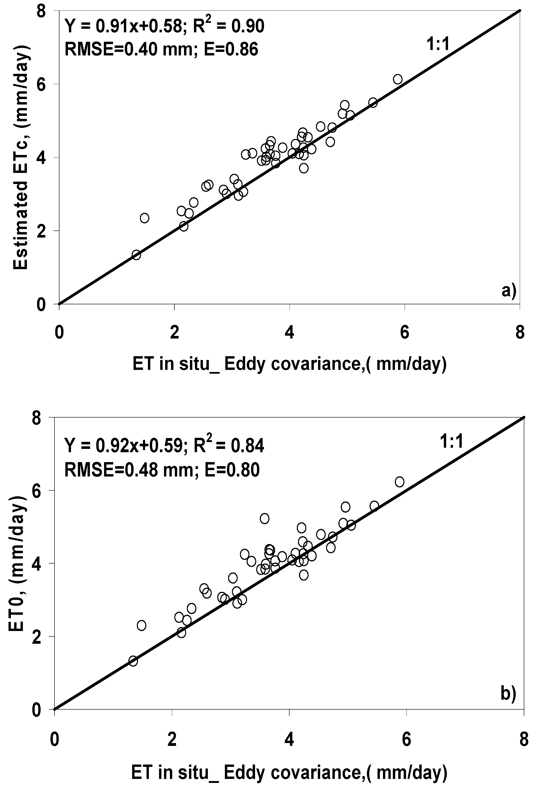
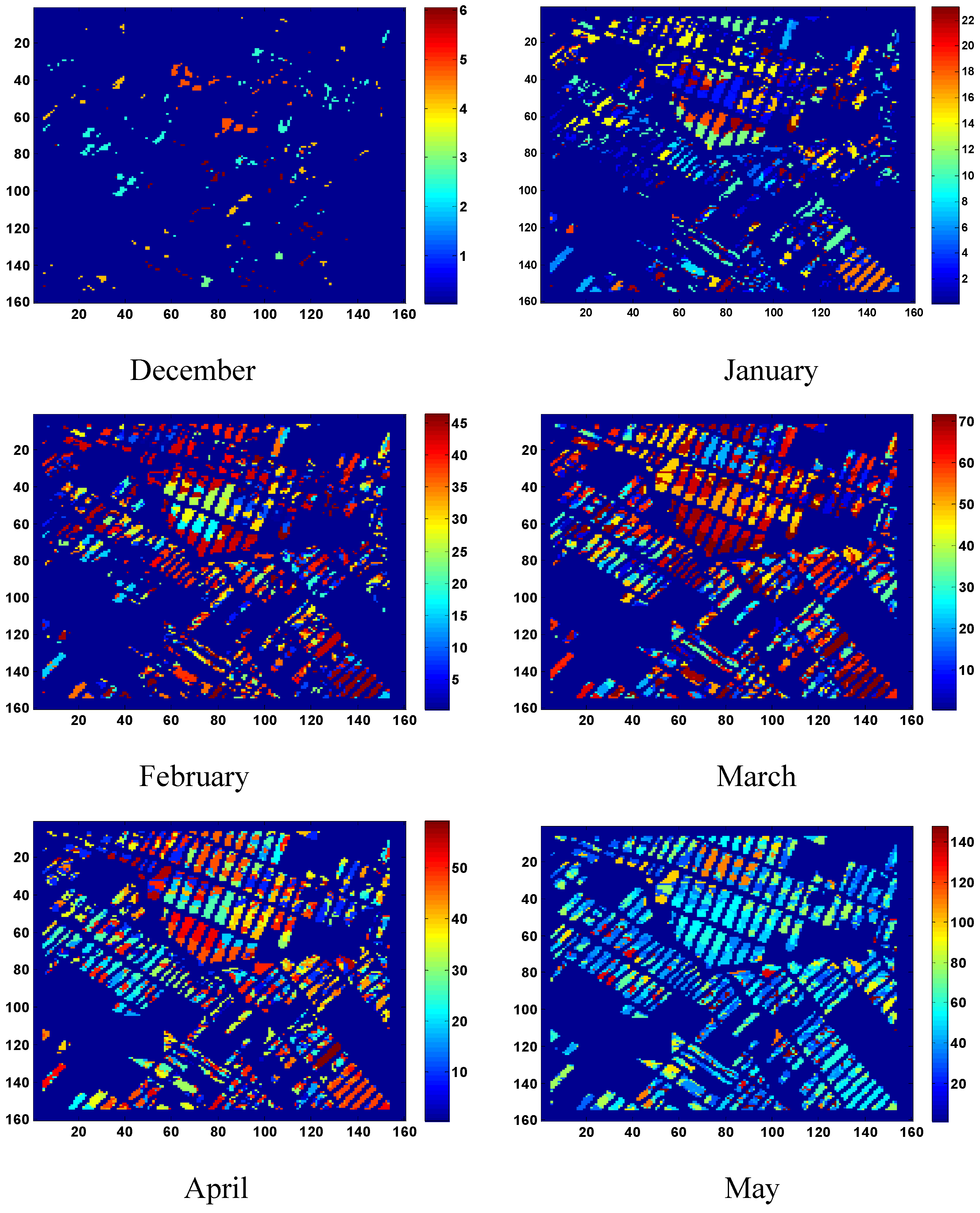
4. Conclusions and Perspectives
5. Acknowledgements
References
- Moran, M.S.; Clarke, T.R.; Inoue, Y.; Vidal, A. Estimating crop water deficit using the relation between surface-air temperature and spectral vegetation index. Remote Sens. Environ. 1994, 49, 246–263. [Google Scholar] [CrossRef]
- Bastiaanssen, W.G.M. SEBAL-based sensible and latent heat fluxes in the irrigated Gediz Basin, Turkey. J. Hydrol. 2000, 229, 87–100. [Google Scholar] [CrossRef]
- Takeuchi, W.; Tamura, M.; Yasuoka, Y. Estimation of methane emission from West Siberian wetland by scaling technique between NOAA AVHRR and SPOT HRV. Remote Sens. Environ. 2003, 85, 9–21. [Google Scholar] [CrossRef]
- Allen, R.G.; Pereira, L.S.; Raes, D.; Smith, M. Crop Evapotranspiration: Guidelines for Computing Crop Water Requirements; FAO Irrigation and Drainage Paper 56; FAO: Rome, Italy, 1998; p. 300. [Google Scholar]
- Jackson, R.D.; Idso, S.B.; Reginato, R.J.; Pinter, P.J., Jr. Remotely sensed crop temperatures and reflectances as inputs to irrigation scheduling. In Irrigation and Drainage: Today’s Challenges; ASCE: New York, NY, USA, 1980; pp. 390–397. [Google Scholar]
- Bausch, W.C.; Neale, C.M.U. Crop coefficients derived from reflected canopy radiation: a concept. Trans. ASAE 1987, 30, 703–709. [Google Scholar] [CrossRef]
- Bausch, W.C. Soil background effects on reflectance-based crop coefficients for corn. Remote Sens. Environ. 1993, 46, 213–222. [Google Scholar] [CrossRef]
- Bausch, W.C. Remote sensing of crop coefficients for improving the irrigation scheduling of corn. Agr. Water Manage. 1995, 27, 55–68. [Google Scholar] [CrossRef]
- Hunsaker, D.J.; Pinter, P.J., Jr.; Barnes, E.M.; Kimball, B.A. Estimating cotton evapotranspiration crop coefficients with a multispectral vegetation index. Irrig. Sci. 2003, 22, 95–104. [Google Scholar] [CrossRef]
- Hunsaker, D.J.; Pinter, P.J., Jr.; Kimball, B.A. Wheat basal crop coefficients determined by normalized difference vegetation index. Irrig. Sci. 2005, 24, 1–14. [Google Scholar] [CrossRef]
- Duchemin, B.; Hadria, R.; Er-Raki, S.; Boulet, G.; Maisongrande, P.; Chehbouni, A.; Escadafal, R.; Ezzahar, J.; Hoedjes, J.; Karrou, H.; Khabba, S.; Mougenot, B.; Olioso, A.; Rodriguez, J.-C.; Simonneaux, V. Monitoring wheat phenology and irrigation in Central Morocco: on the use of relationship between evapotranspiration, crops coefficients, leaf area index and remotely-sensed vegetation indices. Agr. Water Manage. 2006, 79, 1–27. [Google Scholar] [CrossRef]
- Er-Raki, S.; Chehbouni, A.; Guemouria, N.; Duchemin, B.; Ezzahar, J.; Hadria, R. Combining FAO-56 model and ground-based remote sensing to estimate water consumptions of wheat crops in a semi-arid region. Agr. Water Manage. 2007, 87, 41–54. [Google Scholar] [CrossRef]
- Heilman, J.L.; Heilman, W.E.; Moore, D.G. Evaluating the crop coefficient using spectrales reflectance. Agron. J. 1982, 74, 967–971. [Google Scholar] [CrossRef]
- Neale, C.M.U.; Bausch, W.C.; Heerman, D.F. Development of reflectance-based crop coefficients for corn. Trans. ASAE 1989, 32, 1891–1899. [Google Scholar] [CrossRef]
- Choudhury, B.J.; Ahmed, N.U.; Idso, S.B.; Reginato, R.J.; Daughtry, C.S.T. Relations between evaporation coefficients and vegetation indices studies by model simulations. Remote Sens. Environ. 1994, 50, 1–17. [Google Scholar] [CrossRef]
- Gonzalez-Dugo, M.P.; Mateos, L. Spectral vegetation indices for benchmarking water productivity of irrigated cotton and sugarbeet crops. Agr. Water Manage. 2008, 95, 48–58. [Google Scholar] [CrossRef]
- Gonzalez-Piqueras, J.; Calera Belmonte, A.; Gilabert, M.A.; Cuesta García, A.; De la Cruz Tercero, F. Estimation of crop coefficients by means of optimized vegetation indices for corn. In Proceedings of the SPIE Congress, Barcelona, Spain, September, 2003; pp. 110–118.
- Chehbouni, A.; Escadafal, R.; Boulet, G.; Duchemin, B.; Simonneaux, V.; Dedieu, G.; Mougenot, B.; Khabba, S.; Kharrou, H.; Merlin, O.; Chaponnière, A.; Ezzahar, J.; Er-Raki, S.; Hoedjes, J.; Hadria, R.; Abourida, H.; Cheggour, A.; Raibi, F.; Hanich, L.; Guemouria, N.; Chehbouni, Ah.; Lahrouni, A.; Olioso, A.; Jacob, F.; Sobrino, J. The use of remotely sensed data for integrated hydrological modeling in arid and semi-arid regions: the SUDMED program. Int. J. Remote Sens. 2008, 29, 5161–5181. [Google Scholar] [CrossRef]
- Simonneaux, V.; Duchemin, B.; Helson, D.; Er-Raki, S.; Olioso, A.; Chehbouni, A. The use of high-resolution image time series for crop classification and evapotranspiration estimate over an irrigated area in central Morocco. Int. J. Remote Sens. 2007, 29, 95–116. [Google Scholar] [CrossRef]
- Rahman, H.; Dedieu, G. SMAC: a simplified method for the atmospheric correction of satellite measurements in the solar spectrum. Int. J. Remote Sens. 1994, 15, 123–143. [Google Scholar] [CrossRef]
- Schott, J.R.; Salvaggio, C.; Volchock, W.J. Radiometric scene normalization using pseudo invariant features. Remote Sens. Environ. 1988, 26, 1–16. [Google Scholar] [CrossRef]
- D’Urso, G.; Calera Belmonte, A. Operative approaches to determine crop water requirements from earth observation data: methodologies and applications. In Earth Observation for Vegetation Monitoring and Water Management; D’Urso, G., Jochum, M.A.O., Moreno, J., Eds.; American Institute of Physics: Melville, NY, USA, 2006; pp. 14–25. [Google Scholar]
- MacQueen, J.B. Some methods for classification and analysis of multivariate observations. In Proceedings of Fifth Berkeley Symposium on Mathematical Statistics and Probability, Berkeley, CA, USA; 1967; pp. 281–297. [Google Scholar]
- Duchemin, B.; Er-Raki, S.; Gentine, P.; Maisongrande, P.; Coret, L.; Boulet, G.; Rodriguez, J.-C.; Simonneaux, V.; Chehbouni, A.; Dedieu, G.; Guemouria, N. Estimating Cereal Evapotranspiration using a Simple Model driven by Satellite Data. In Proceding of IEEE International Geoscience and Remote Sensing Symposium, Toulouse, France, 2003; pp. 21–25.
- Er-Raki, S.; Chehbouni, A.; Guemouria, N.; Duchemin, B.; Ezzahar, J.; Hadria, R.; BenHadj, I. Driven FAO-56 dual crop coefficient approach with remotely-sensed data for estimating water consumptions of wheat crops in a semi-arid region. In Second Recent Advances in Quantitative Remote Sensing; Sobrino, J.A., Ed.; Universitat de Valencia: Valencia, Spain, 2006; pp. 431–437. [Google Scholar]
- Bamouh, A. Effets d'une sécheresse en début de cycle sur l'élaboration du rendement du blé tendre "Nesma 149"; Mémoire de Troisième Cycle, Institut Agronomique et Vétérinaire Hassan II: Rabat, Morocco, 1981. [Google Scholar]
- Elqortobi, A. Simulation du déficit hydrique et prédiction des rendements des céréales d’automne; Mémoire de 3éme cycle Agronomie, Département d’agronomie, IAV Hassan II: Rabat, Morocco, 1987. [Google Scholar]
- Er-Raki, S.; Chehbouni, A.; Hoedjes, J.; Ezzahar, J.; Duchemin, B.; Jacob, F. Improvement of FAO-56 method for olive orchards through sequential assimilation of thermal infrared based estimates of ET. Agr. Water Manage. 2008, 95, 309–321. [Google Scholar] [CrossRef]
Appendix: K-means Method
- Step 1: choose randomly k centers of classes
- Step 2: Assign to k centers each object to the group that has the closest centroid.
- Step 3: Recalculate the positions of the centroids.
- Step 4: If the positions of the centroids didn't change go to the next step, else go to Step 2.
- Step 5: End.
© 2010 by the authors; licensee Molecular Diversity Preservation International, Basel, Switzerland. This article is an open-access article distributed under the terms and conditions of the Creative Commons Attribution license ( http://creativecommons.org/licenses/by/3.0/).
Share and Cite
Er-Raki, S.; Chehbouni, A.; Duchemin, B. Combining Satellite Remote Sensing Data with the FAO-56 Dual Approach for Water Use Mapping In Irrigated Wheat Fields of a Semi-Arid Region. Remote Sens. 2010, 2, 375-387. https://doi.org/10.3390/rs2010375
Er-Raki S, Chehbouni A, Duchemin B. Combining Satellite Remote Sensing Data with the FAO-56 Dual Approach for Water Use Mapping In Irrigated Wheat Fields of a Semi-Arid Region. Remote Sensing. 2010; 2(1):375-387. https://doi.org/10.3390/rs2010375
Chicago/Turabian StyleEr-Raki, Salah, Abdelghani Chehbouni, and Benoit Duchemin. 2010. "Combining Satellite Remote Sensing Data with the FAO-56 Dual Approach for Water Use Mapping In Irrigated Wheat Fields of a Semi-Arid Region" Remote Sensing 2, no. 1: 375-387. https://doi.org/10.3390/rs2010375
APA StyleEr-Raki, S., Chehbouni, A., & Duchemin, B. (2010). Combining Satellite Remote Sensing Data with the FAO-56 Dual Approach for Water Use Mapping In Irrigated Wheat Fields of a Semi-Arid Region. Remote Sensing, 2(1), 375-387. https://doi.org/10.3390/rs2010375


