In an increasingly food insecure world, there is a critical need for us to have a comprehensive understanding of global croplands. The reality that the “green revolution” has ended is beginning to be felt around the World. Whereas, global population continues to increase at a rate of about 100 million per year and is expected to reach around 10 billion by 2050, cropland areas are not increasing and have stagnated around 1.5 billion hectares globally. Indeed, cropland areas have even begun to decrease in some countries with important food contribution (e.g., USA) due to increasing demand of fertile arable lands for alternative uses such as bio-fuels, encroachment from urbanization, and industrialization. The ecological and environmental imperatives have put a cap on further increase of cropland areas to other lands such as forests and rangelands. These issues leave us with a fundamental and urgent question to answer: “
how does the world ensure food security for its ballooning population without having to increase cropland areas and\or water allocations?”.
Indeed, even better question to ask is: “
how does the world ensure food security for its ballooning population even by reducing the existing cropland areas and\or water allocations?”. Solutions such as from bio-technology and precision farming may come through but it is not currently moving at a rate that will ensure global food security over next few decades. Further, there is a need for careful consideration of possible harmful effects of bio-technology. We should not be looking back 30–50 years from now, like we have been looking back now at many mistakes made during the green revolution where the focus was only on getting more yield per unit area without much thought about serious damage done to our natural environments, water resources, and human health as a result of detrimental factors such as uncontrolled use of herbicides-pesticides-nutrients, drastic groundwater mining, and salinization of fertile soils due to over irrigation. Currently, there is a talk about a “second green revolution” or even an “ever green revolution”, but clear ideas on what actually these terms mean are still debated and are evolving. The first green revolution (increase in productivity per unit of land) came through a series of factors: high-yielding varieties, fast growing varieties, irrigation, supplemental irrigation, crop intensification, and farm management (e.g., application of nutrients, herbicides, pesticides, and drainage) (see
Figure 1).
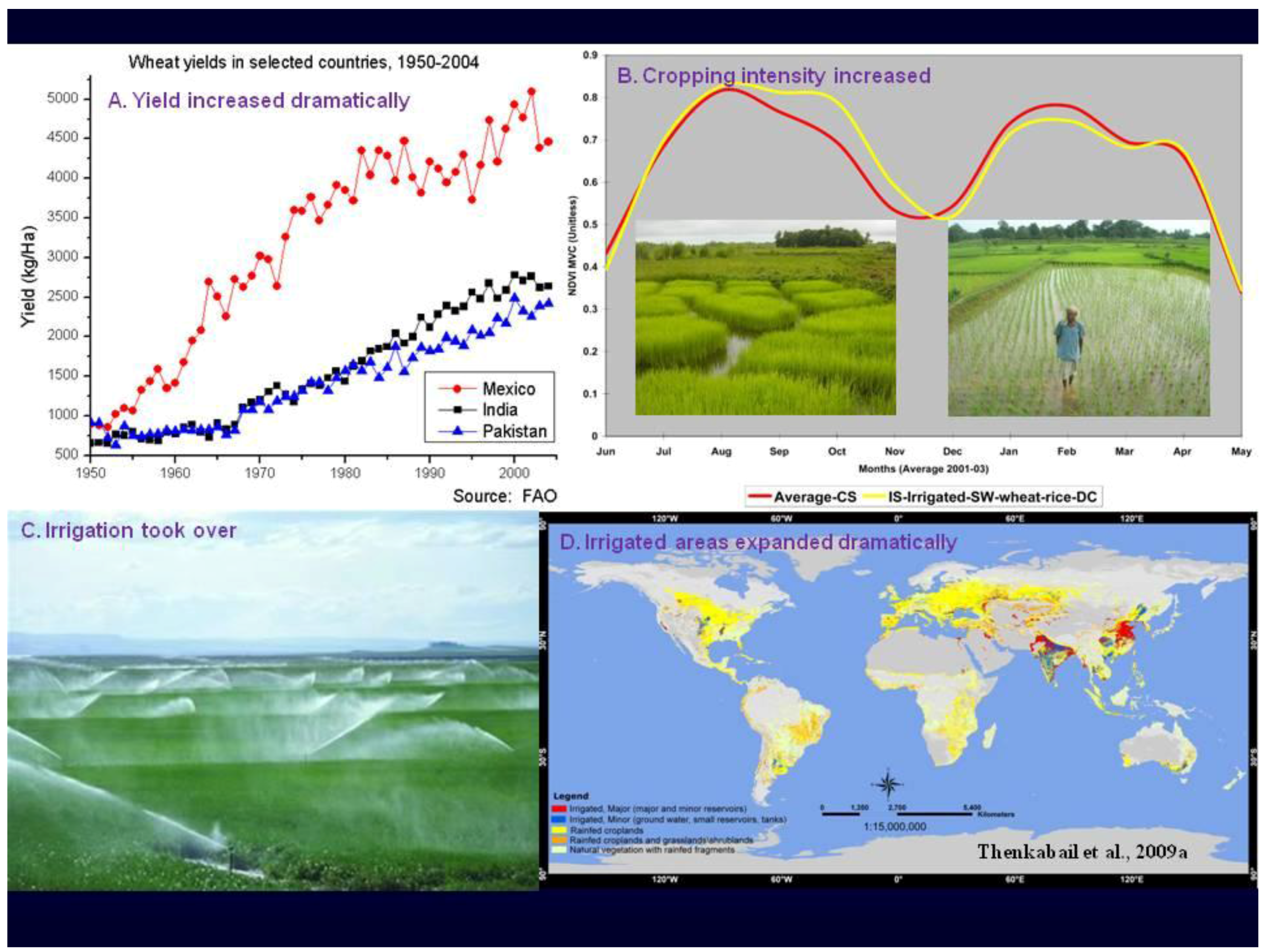
Figure 1.
Green revolution (productivity per unit of land). Some of the major factors that helped achieve green revolution (years: 1955–2005) are illustrated. These factors included: (A) swift rise in yield per unit of land (e.g., through better land management, introduction of high-fast yield varieties, fertilizer, nutrients, and herbicides), (B) crop intensification (e.g., double and triple crop per year), (C) massive investments in irrigation, and (D) increase in cropland areas.
But after nearly half a century of green revolution era (roughly, 1955–2005), the World finds itself with number of problems associated with it, such as: salinization, deep mining for ground water resulting in its fast depletion to levels that are no more sustainable, surface and ground water pollution due to over application of herbicides-pesticides-nutrients, and over use of water for irrigation. It is clear that unless these issues are addressed adequately and new technologies like bio-technology is sufficiently clean, the required parameters for moving towards a “second green revolution” or “ever green revolution” will be hard to visualize, let alone implement. One of the biggest issues that is not given adequate focus is the use of large quantities of water for food production. Indeed, an overwhelming proportion (about 80%) of all human water use goes for producing our food. Of all the water used by humans for growing food, about 65 percent is consumed by green water use (for growing food in about 1.13 billion hectares of rainfed croplands of the World from direct rain and soil moisture from unsaturated zone) and the rest 35 percent is consumed by blue water use (for growing food in about 400 million hectares of irrigated croplands of the World obtained from reservoirs, barrages, lakes, rivers, and deep aquifer groundwater). But such heavy water use for food production is no more tenable due to increasing pressure for alternative water use such as for increasing urbanization, industrialization, environmental flows, bio-fuels, and recreation. This has brought to sharp focus the need to grow more food per drop of water (or more crop per drop) leading to a “blue revolution” (see
Figure 2). These imperatives make us to focus on producing more food in coming decades and in the present century from: (a) existing cropland areas, and (b) existing water allocations. Indeed, even better will be to focus on ideas that will focus on producing more and more food from less and less croplands and less and less water allocations- thus helping us to truly move towards an “ever green revolution” that combines the “best of green revolution” (a second green revolution) and a “blue revolution” (
Figure 1 and
Figure 2).
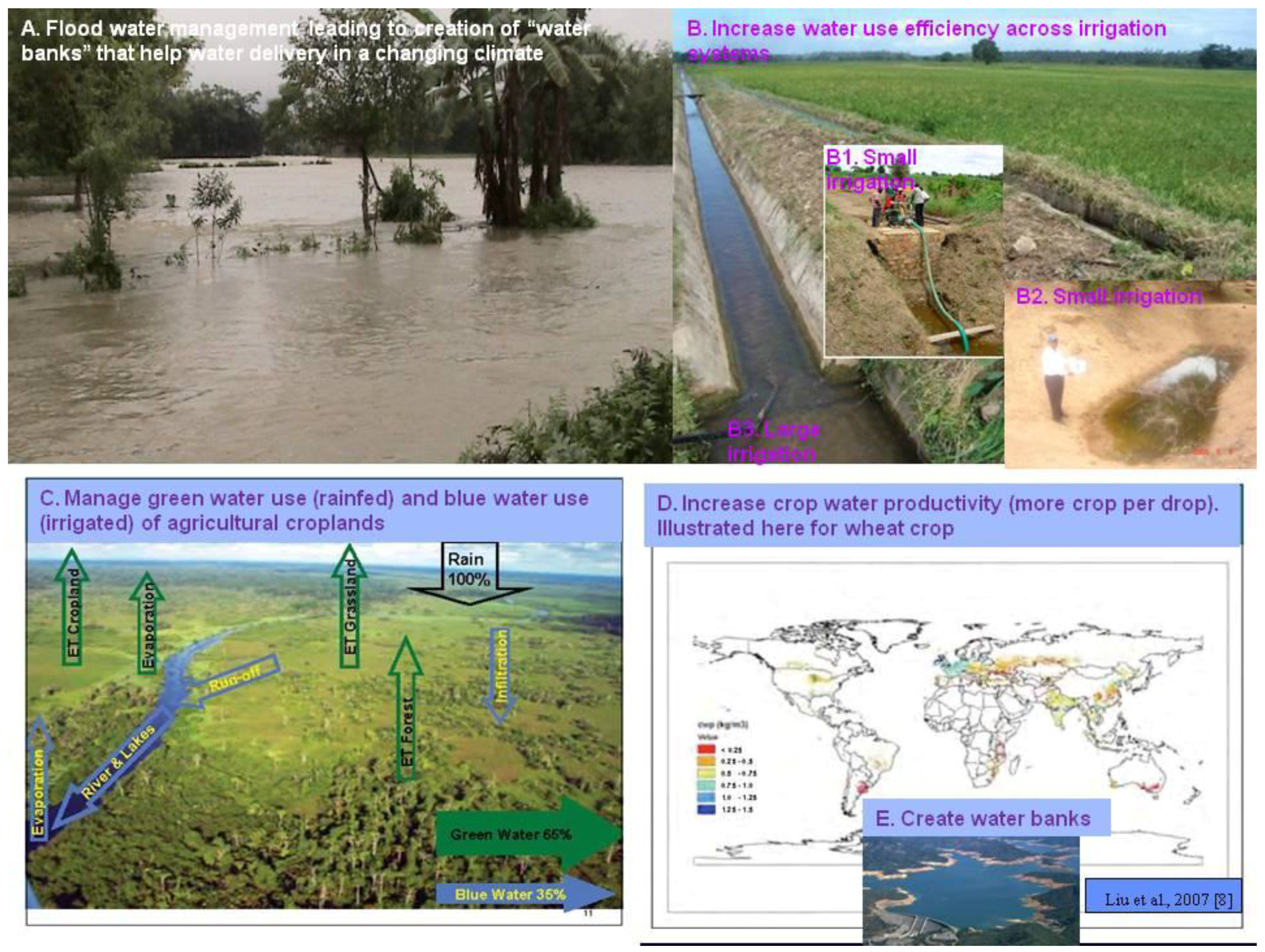
Figure 2.
Blue revolution (productivity per unit of water). A blue revolution must, in the least, should include: (A) creating “water banks” (e.g., store massive floods in certain years such as the great Indus river floods of the year 2010 as “water banks” in thousands of lakes for use during lean years and develop effective water distribution system for distribute this water during drought years), (B) increasing water use efficiency (e.g., of major and minor irrigation systems), (C) advancing water management (e.g., “green water use”—water in soil moisture and by direct rain and “blue water use”—water in lakes, rivers, reservoirs, and deep aquifers management), and (D) increasing crop water productivity (e.g., crop per drop).
The need for addressing World’s food security in coming decades and the present century is critical and urgent. However, for this to happen, one of the primary requirements will be to have an advanced geospatial information system. Such a system should be global, consistent across nations and regions, and in the least, provide such critical information as: (a) crop types, (b) precise location of crops, (c) cropping intensities (e.g., single crop, double crop), (d) cropping calendar, (e) crop health\vigor, (f) watering methods (e.g., irrigated, supplemental irrigated, rainfed), (g) flood and drought information, (h) water use assessments, and (g) yield or productivity (expressed per unit of land and\or unit of water). Opportunities to set-up such a global system is best achieved using fusion of advanced remote sensing (e.g., fusion of Landsat, Resourcesat, MODIS) in combination with national statistics, ancillary data (e.g., elevation, precipitation, temperature), and field-plot data. But such a system, at global level, will be complex in data handling and processing and requires coordination of with multiple agencies leading to development of a seamless, scalable, and repeatable methodology. There is substantial progress in this effort in last few years [
1,
2,
3,
4,
5,
6,
7].
Given the above background, the purpose of this special issue on “Global Croplands” was to bring in the best of experts in the field of global croplands-their water use-food security, from around the World, and advance existing knowledge in area of global cropland mapping and link it to green water use (for growing food from rainfed croplands) and blue water use (for growing food from irrigated croplands). The overarching goal of the special issue was to develop a knowledge bank to create a robust system of systems for global agricultural cropland monitoring and it’s water use that would lead to an effective geospatial information system on agricultural croplands and its water use, which in turn will contribute to development of a secure food security system for coming decades and this century.
The call for the “global croplands” special issue resulted in many submissions, careful review, and acceptance of 21 well written articles (
https://www.mdpi.com/journal/remotesensing/special_issues/croplands/) for publication. These articles covered a range of topics on global croplands as well as subjects that are closely linked to croplands such as their water use and food security analysis using geospatial technologies-especially remote sensing that significantly complements and supplements the recent advances reported elsewhere [
1,
2,
3,
4,
5,
6,
7]. The articles in this special issue fall under the following broad categorization:
Review of global cropland mapping, monitoring, and characterization;
Enumeration on data, approaches, and methods of global and local cropland mapping;
Development of a framework of global agricultural monitoring system;
Crop yield and productivity modeling;
Assessment of water use by global croplands;
Modeling of global cropland water use;
Linking global croplands to water use;
Linking global croplands and their water use to food security;
Assessing water footprint of crops;
Analyzing food security in a changing climate.
The collective knowledge base from these articles significantly adds to already existing knowledge on global croplands [
1,
2,
3,
4,
5,
6,
7] and facilitates us to strategize a world of global food security. A very brief overview of these papers is discussed in the following paragraphs.
Thenkabail
et al. provided a holistic view of global croplands and their water use using remote sensing and non-remote sensing data, approaches, and methods. They do a thorough review of existing global cropland maps and statistics and then provide a country-by-country assessment of global cropland areas and their water use. The paper highlights the linkages between croplands, their water use, and food security at global level. Their review showed that although most cropland studies agreed that there was about 1.5 billion hectares as global cropland areas in year 2000, these studies significantly differ in: (a) precise geographic location of the cropland areas, and (b) proportion of areas under irrigation versus supplemental irrigation versus pure rainfed. These discrepancies can have serious uncertainties in water use modeling. Ozdogan
et al. provided a comprehensive review of irrigated cropland mapping methods and approaches at local to global levels. They established that the multi-temporal remote sensing data provides the greatest accuracy in irrigated area mapping. Nevertheless, they point out that remote sensing techniques have well established record of accurately mapping and studying irrigated areas only at local scales, but face numerous challenges for mapping over larger areas such as the continents and the globe. Whereas this is true to a great extent, there are substantial advances in large area cropland mapping. These include: (a) data fusion (e.g., Landsat, MODIS time-series, secondary), and (b) new satellite sensor constellations such as Rapideye that is specifically targeted for agriculture with nominal 5 m data in 5 bands including a band in red-edge. Pittman
et al. demonstrated the high value of time-series MODIS data to rapidly estimate global cropland extent. The approach is easily repeatable and rapid. The MODIS NDVI threshold approach in their study matches MODIS remote sensing derived areas with areas reported by countries (e.g., when they match a MODIS NDVI threshold derives areas to a specific country statistic or areas reported by Foreign Agricultural Service (FAS) of USDA).
However, such an approach matches areas, but does not always match the precise location of these areas- leading to significant uncertainties in both areas and their precise locations. Also, area calculations using MODIS data will be more accurate when sub-pixel area fractions are determined precisely [
1,
2]. One of the strengths of MODIS data is in its ability to determine cropland intensities (e.g., double cropping, triple cropping). Siebert
et al. determine global patterns of cropland and fallow land intensities. This paper makes an important contribution as almost all global cropland studies have ignored fallow dynamics. Indeed, Siebert
et al. found that of the 1.6 billion hectares of croplands, nearly 28% was fallow during year 2000. Cropland fallows are ever changing and are more prominent in certain places (e.g., Africa) relative to other places (e.g., USA). Specific methods of irrigated cropland mapping using satellite sensor data fusion involving various resolutions (e.g., 2.5 m to 30 m) and a suite of methods (e.g., a rule based on tassel cap) is discussed by Conrad
et al. Remote sensing data and methods offer an excellent platform for Crop yield and productivity modeling as demonstrated by Hatfield and Prueger, Laurila
et al., and Panda
et al. using multi-sensor vegetation indices, neural network techniques, multiple data fusion techniques, and modeling. Typically, broad-band optical remote sensing explains about 70% variability in crop yields. However, with innovative approaches involving multi-data fusion, it is possible to improve models to explain greater variability. Laurila
et al., for example, found SAR/ASAR data better explained yield accumulation, grain filling, and senescence estimation during generative phases of crop growth. Further, ability to observe change over space and time in a consistent and continual manner is one of the biggest advantages offered by remote sensing. This is well demonstrated in a study Matejicek and Kopackova They showed how large scale mining in agricultural lands are continually monitored using Landsat data and how agricultural land cover changes effect food security. These papers provide an excellent mix of data, approaches, and methods of global and local cropland area mapping, modeling, and monitoring.
Opportunities to use the above discussed data, methods, and approaches in a monitoring framework is presented and discussed by Inbal Becker-Reshef et al. They present a comprehensive remote sensing based global agricultural monitoring system under a Global Agriculture Monitoring Project (GLAM)—a joint effort of NASA, USDA, UMD and SDSU. This system presents remote sensing data, derived products, and analysis tools of GLAM for agricultural crop-condition monitoring and production assessment at global level. The goal of the effort is to supplement and complement and improve the existing USDA’s Foreign Agricultural Service (FAS) Decision Support System (DSS) for crop-condition monitoring and production assessment.
An overwhelming proportion of human water use is consumed for food production through irrigated areas (blue water use) and rainfed areas (green water use)- see the paper by Thenkabail et al.. Crop water use is determined using surface energy balance modeling as discussed by Nagler et al., Murray et al., and Teixeira et al. The ability to quantify water use by various agricultural crops and natural vegetation as discussed in these 3 papers will help us see which crops or vegetation types are water guzzlers and which are not. This is especially important in an increasingly water scarce World in a changing climate (see the paper by Cheesbrough et al.). This will help us plant less water consuming crops to produce our food and\or adopt strategies to increase productivity even when less and less water is used through better water productivity measures. Here the concept of water footprint of crops (WFC) is very useful. The WFC is a concept defined by how much water is consumed to produce unit of food. By such assessments, we can pin-point areas of high and low WFC and plan to increase WFC to increase productivity by consuming less and less water, resulting in water savings. The global assessments of WFCs using remote sensing are discussed in detail by Romaguera et al.
There are considerable conflicts in using land and water for food production versus fuel production (e.g., ethanol). Remote sensing data and methods are ideally suited for monitoring and planning land use for agricultural croplands or for ethanol fuel production and establishing trade-offs involving the two. This trade-off is studied in detail for Sugarcane production for Ethanol in São Paulo State (Brazil) by Rudorff et al. Similarly, there is significant competition for croplands for increasingly urban modern societies. This is not just for building urban housing and industries, but equally or even more for urban and peri-urban agriculture. Even though, about 800 million people practice urban/peri-urban agriculture, there is true lack of systematic knowledge and characterization of the same and remote sensing and geospatial technologies offer the best opportunities to study the same as discussed in a paper by Addo.
Both croplands and their water use are tightly linked to food security. The changing climate is leading to uncertainty in rainfall amount and distribution, rise in temperatures, and reductions in snow-melt runoff in many parts of the World. Much of the green revolution was sustained by irrigation, which overcame some of these climate induced changes over space and time. Further, green revolution was also sustained by massive exploitation of deep aquifer groundwater. But, this is an unsustainable model of development that is also environmentally detrimental. These critical issues are studied in a paper by Milesi
et al. taking Indian example, where these issues are most pressing, using decadal NDVI. At the same time, we have massive floods in many parts of the world. If the water can be stored in “water banks” during these flood events, they can supply water for several lean years through well organized distribution system. These innovative measures are required to adapt to climate change. Measures such as these can lead to “ever green revolution” that combines the best of green revolution with blue revolution (
Figure 1 and
Figure 2) where water shortages for food and livelihood are things of past bygone era.
Croplands are mapped and studied using numerous geospatial data, methods, models, and approaches. Yet, farmers require a simple system to make timely decisions. For this, Zhang et al. proposed and demonstrated a web based remote sensing data dissemination system for the Digital Northern Great Plains (DNGP) of the United States. In this they propose and implement a range of practical applications that support timely and cost-effective decision making by farmers as well demonstrate a free remote sensing and other spatial data and product sharing platform. Farmers need to implement advance farming methods such as precision farming in order to maximize production through land suitability studies and minimize environmental impacts by minimizing application of herbicides, pesticides, and fertilizers. These approaches are discussed by Panda, Hoogenboom, and Paz. Increasingly the need for using fusion of multi-resolution, multi-sensor data are becoming increasingly important for successful applications on various issues related to croplands. These methods and approaches are discussed extensively in one or the other 21 published papers. Demattê et al., for example, show how hyperspectral narro-band indices can be used to advance our understanding of soil analysis. Papers by Thenkabail et al., Ozdogon et al., Pittman et al., Siebert et al., and Becker-Reshef et al. review and highlight many of these methods and approaches. They also show pathway to advance our understanding in cropland mapping in the future.
More coordinated and intense efforts for global cropland mapping are beginning to take place through Agricultural Societal Beneficial Areas (Agriculture SBA;
http://www.earthobservations.org/geoss_ag.shtml) of Group of Earth Observations (GEO) and Global Earth Observing System of Systems (GEOSS). This special issue on “Global Croplands”, with articles from “who is who” from around the world working on global croplands, makes a significant contribution towards that and similar efforts in order for us to ensure a food secure world for the present Century.
Finally, I want the reader to take a close look at “article statistics” of each paper (click on the “article”, it takes you to article statistics apart from abstract and pdf of article). For example, if you click on Milesi et. al. paper you will see it was published on June 19, 2010 and by September 19, 2010 it had 515 paper downloads and 848 abstract views-quite impressive. This is also a great way to keep track of interest by readers on each article.
