
Sentinel-2A MSI and Landsat 8 OLI Provide Data Continuity for Geological Remote Sensing


Abstract
:
1. Introduction
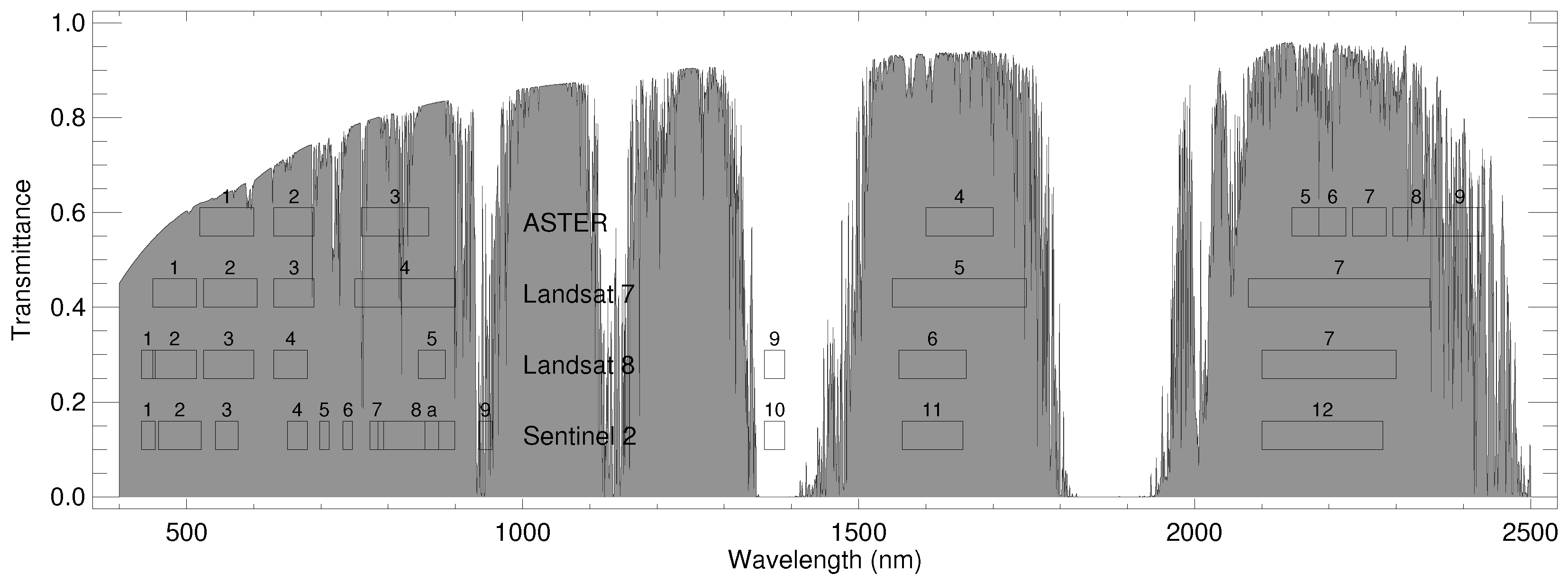
2. Method
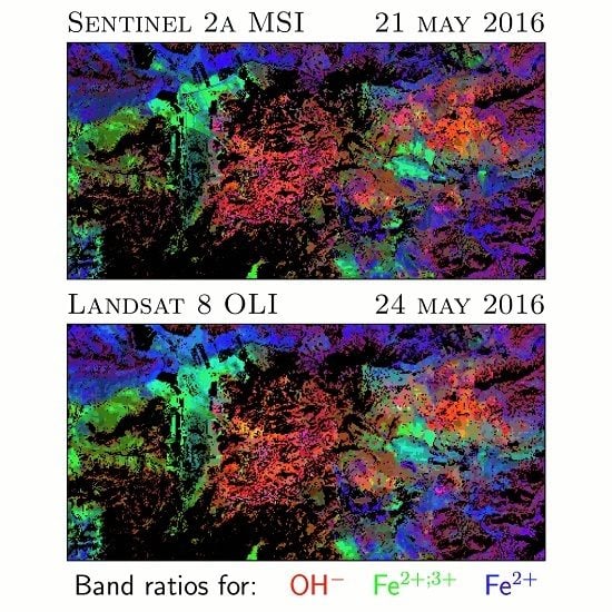
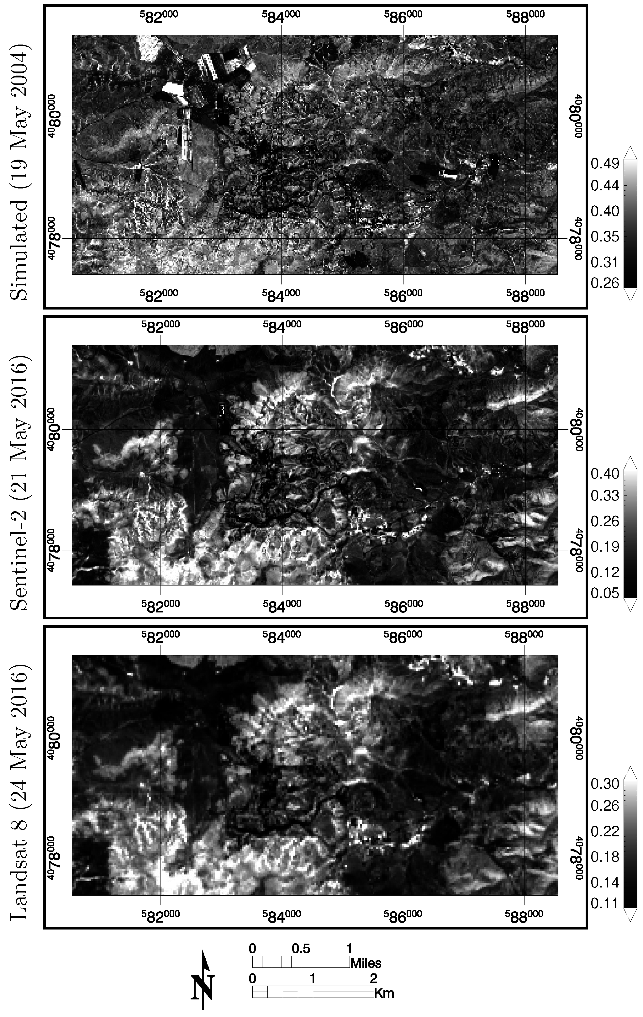
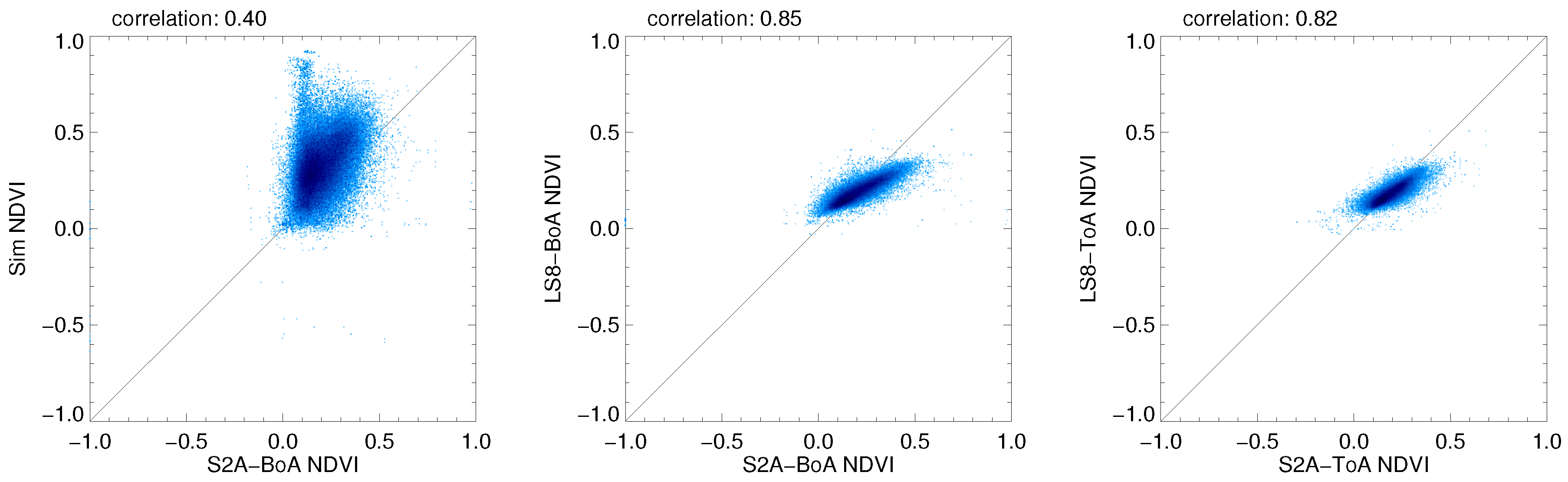
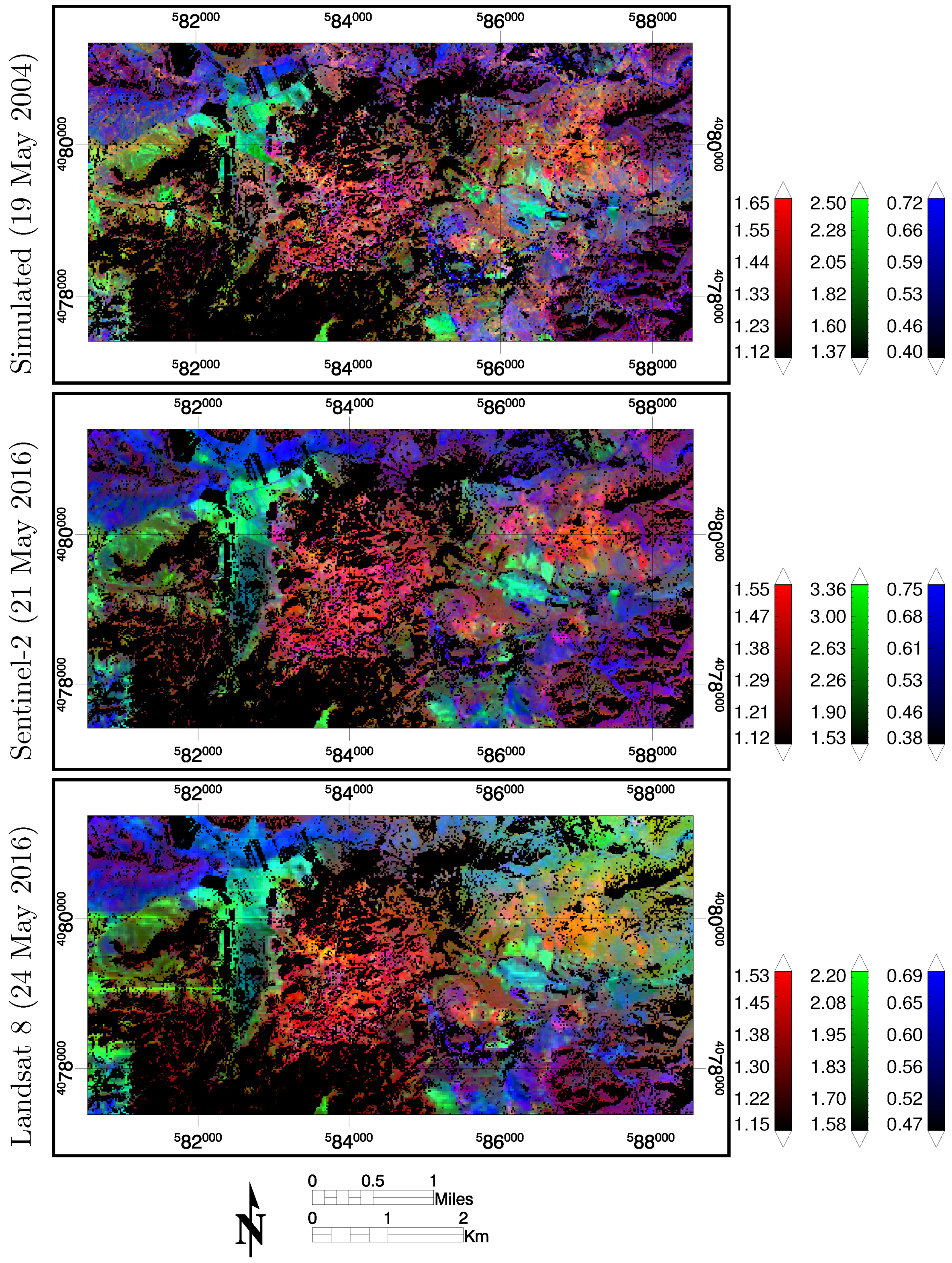
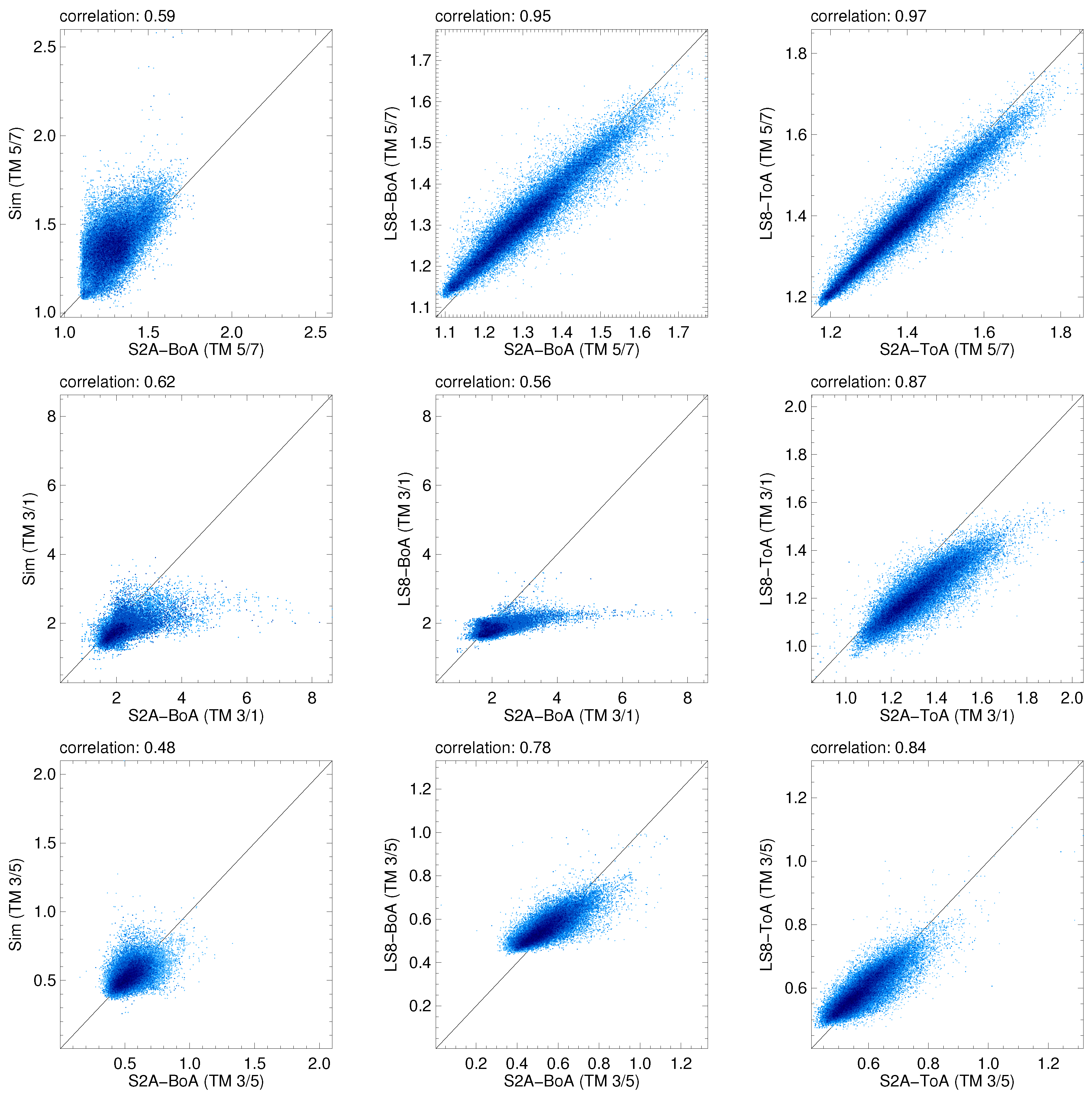
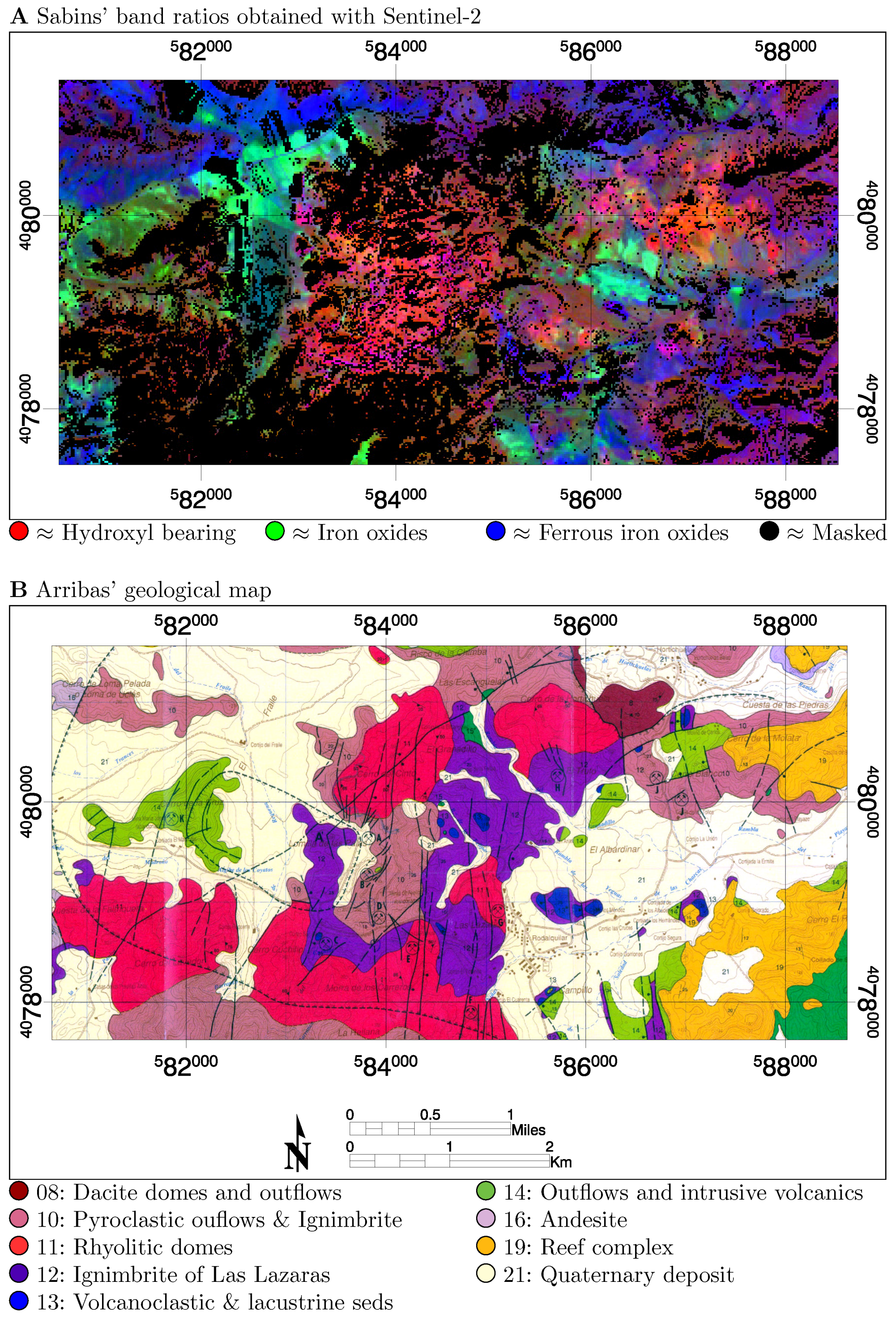
3. Results
4. Discussion
5. Conclusions
Supplementary Materials
Acknowledgments
Author Contributions
Conflicts of Interest
References
- Berger, M.; Moreno, J.; Johannessen, J.A.; Levelt, P.F.; Hanssen, R.F. ESA’s sentinel missions in support of Earth system science. Remote Sens. Environ. 2012, 120, 84–90. [Google Scholar] [CrossRef]
- Drusch, M.; Del Bello, U.; Carlier, S.; Colin, O.; Fernandez, V.; Gascon, F.; Hoersch, B.; Isola, C.; Laberinti, P.; Martimort, P.; et al. Sentinel-2: ESA’s optical high-resolution mission for GMES operational services. Remote Sens. Environ. 2012, 120, 25–36. [Google Scholar] [CrossRef]
- Yan, L.; Roy, D.; Zhang, H.; Li, J.; Huang, H. An automated approach for sub-pixel registration of Landsat-8 Operational Land Imager (OLI) and Sentinel-2 Multi Spectral Instrument (MSI) imagery. Remote Sens. 2016, 8, 520. [Google Scholar] [CrossRef]
- European Space Agency. ESA Sentinel-2 Delivers First Images. Available online: http://www.esa.int/Our_Activities/Observing_the_Earth/Copernicus/Sentinel-2/Sentinel-2_delivers_first_images (accessed on 28 September 2016).
- Malenovský, Z.; Rott, H.; Cihlar, J.; Schaepman, M.; García-Santos, G.; Fernandes, R.; Berger, M. Sentinels for science: Potential of Sentinel-1, -2 and -3 missions for scientific observations of ocean, cryosphere, and land. Remote Sens. Environ. 2012, 120, 91–101. [Google Scholar] [CrossRef]
- Atzberger, C.; Richter, K. Spatially constrained inversion of radiative transfer models for improved LAI mapping from future Sentinel-2 imagery. Remote Sens. Environ. 2012, 120, 208–218. [Google Scholar] [CrossRef]
- Richter, K.; Hank, T.B.; Vuolo, F.; Mauser, W.; D’Urso, G. Optimal exploitation of the Sentinel-2 spectral capabilities for crop leaf area index mapping. Remote Sens. 2012, 4, 561–582. [Google Scholar] [CrossRef] [Green Version]
- Richter, K.; Atzberger, C.; Vuolo, F.; Weihs, P.; D’Urso, G. Experimental assessment of the Sentinel-2 band setting for RTM-based LAI retrieval of sugar beet and maize. Can. J. Remote Sens. 2009, 35, 230–247. [Google Scholar] [CrossRef]
- Clevers, J.G.P.W.; Gitelson, A.A. Remote estimation of crop and grass chlorophyll and nitrogen content using red-edge bands on Sentinel-2 and -3. Int. J. Appl. Earth Obs. Geoinform. 2013, 23, 344–351. [Google Scholar] [CrossRef]
- Frampton, W.J.; Dash, J.; Watmough, G.; Milton, E.J. Evaluating the capabilities of Sentinel-2 for quantitative estimation of biophysical variables in vegetation. ISPRS J. Photogramm. Remote Sens. 2013, 82, 83–92. [Google Scholar] [CrossRef]
- Verrelst, J.; Munoz, J.; Alonso, L.; Delegido, J.; Rivera, J.P.; Camps-Valls, G.; Moreno, J. Machine learning regression algorithms for biophysical parameter retrieval: Opportunities for Sentinel-2 and -3. Remote Sens. Environ. 2012, 118, 127–139. [Google Scholar] [CrossRef]
- Delegido, J.; Verrelst, J.; Meza, C.M.; Rivera, J.P.; Alonso, L.; Moreno, J. A red-edge spectral index for remote sensing estimation of green LAI over agroecosystems. Eur. J. Agron. 2013, 46, 42–52. [Google Scholar] [CrossRef]
- Hill, M. Vegetation index suites as indicators of vegetation state in grassland and savanna: An Analysis with simulated SENTINEL 2 data for a North American transect. Remote Sens. Environ. 2013, 137, 94–111. [Google Scholar] [CrossRef]
- Salama, M.S.; Radwan, M.; van der Velde, R. A hydro-optical model for deriving water quality variables from satellite images (HydroSat): A case study of the Nile River demonstrating the future Sentinel-2 capabilities. Phys. Chem. Earth 2012, 50–52, 224–232. [Google Scholar] [CrossRef]
- Hedley, J.; Roelfsema, C.; Koetz, B.; Phinn, S. Capability of the Sentinel 2 mission for tropical coral reef mapping and coral bleaching detection. Remote Sens. Environ. 2012, 120, 145–155. [Google Scholar] [CrossRef]
- Van der Meer, F.D.; van der Werff, H.M.A.; van Ruitenbeek, F.J.A. Potential of ESA’s Sentinel-2 for geological applications. Remote Sens. Environ. 2014, 148, 124–133. [Google Scholar] [CrossRef]
- Goetz, A.F.H.; Rowan, L.C. Geologic remote-sensing. Science 1981, 211, 781–791. [Google Scholar] [CrossRef] [PubMed]
- Abrams, M. The Advanced Spaceborne Thermal Emission and Reflection Radiometer (ASTER): Data products for the high spatial resolution imager on NASA’s Terra platform. Int. J. Remote Sens. 2000, 21, 847–859. [Google Scholar] [CrossRef]
- Abrams, M.; Hook, S.J. Simulated ASTER data for geologic studies. IEEE Trans. Geosci. Remote Sens. 1995, 33, 692–699. [Google Scholar] [CrossRef]
- Yamaguchi, Y.; Kahle, A.B.; Tsu, H.; Kawakami, T.; Pniel, M. Overview of Advanced Spaceborne Thermal Emission and Reflection Radiometer (ASTER). IEEE Trans. Geosci. Remote Sens. 1998, 36, 1062–1071. [Google Scholar] [CrossRef]
- Cudahy, T.; Hewson, R. ASTER geological case histories: Porphyry-skarn-epithermal, iron oxide Cu-Au and Broken Hill Pb-Zn-Ag. In Proceedings of the Annual General Meeting of the Geological Remote Sensing Group (ASTER Unveiled), London, UK, 5–7 December 2002.
- Mielke, C.; Boesche, N.; Rogass, C.; Kaufmann, H.; Gauert, C.; de Wit, M. Spaceborne mine waste mineralogy monitoring in South Africa, applications for modern push-broom missions: Hyperion/OLI and EnMAP/Sentinel-2. Remote Sens. 2014, 6, 6790–6816. [Google Scholar] [CrossRef]
- Van der Werff, H.; van der Meer, F. Sentinel-2 for mapping iron absorption feature parameters. Remote Sens. 2015, 7, 12635–12653. [Google Scholar] [CrossRef]
- Immitzer, M.; Vuolo, F.; Atzberger, C. First experience with Sentinel-2 data for crop and tree species classifications in central Europe. Remote Sens. 2016, 8, 166. [Google Scholar] [CrossRef]
- Clasen, A.; Somers, B.; Pipkins, K.; Tits, L.; Segl, K.; Brell, M.; Kleinschmit, B.; Spengler, D.; Lausch, A.; Förster, M. Spectral unmixing of forest crown components at close range, airborne and simulated Sentinel-2 and EnMAP spectral imaging scale. Remote Sens. 2015, 7, 15361–15387. [Google Scholar] [CrossRef]
- Dotzler, S.; Hill, J.; Buddenbaum, H.; Stoffels, J. The potential of EnMAP and Sentinel-2 data for detecting drought stress phenomena in deciduous forest communities. Remote Sens. 2015, 7, 14227–14258. [Google Scholar] [CrossRef]
- Dong, T.; Meng, J.; Shang, J.; Liu, J.; Wu, B. Evaluation of chlorophyll-related vegetation indices using simulated Sentinel-2 data for estimation of crop fraction of absorbed photosynthetically active radiation. IEEE J. Sel. Top. Appl. Earth Obs. Remote Sens. 2015, 8, 4049–4059. [Google Scholar] [CrossRef]
- Sibanda, M.; Mutanga, O.; Rouget, M. Examining the potential of Sentinel-2 MSI spectral resolution in quantifying above ground biomass across different fertilizer treatments. ISPRS J. Photogramm. Remote Sens. 2015, 110, 55–65. [Google Scholar] [CrossRef]
- Du, Y.; Zhang, Y.; Ling, F.; Wang, Q.; Li, W.; Li, X. Water bodies’ mapping from Sentinel-2 imagery with Modified Normalized Difference Water Index at 10-m spatial resolution produced by sharpening the SWIR band. Remote Sens. 2016, 8, 354. [Google Scholar] [CrossRef] [Green Version]
- Toming, K.; Tiit Kutser, T.; Laas, A.; Sepp, M.; Paavel, B.; Nõges, T. First experiences in mapping lake water quality parameters with Sentinel-2 MSI imagery. Remote Sens. 2016, 8, 640. [Google Scholar] [CrossRef]
- Stratoulias, D.; Balzter, H.; Sykioti, O.; Zlinszky, A.; Tóth, V. Evaluating sentinel-2 for lakeshore habitat mapping based on airborne hyperspectral data. Sensors 2015, 15, 22956–22969. [Google Scholar] [CrossRef] [PubMed]
- Rytuba, J.J.; Arribas, A.; Cunningham, C.G.; McKee, E.H.; Podwysocki, M.H.; Smith, J.G.; Kelly, W.C. Mineralized and unmineralized calderas in Spain; Part II, Evolution of the Rodalquilar caldera complex and associated gold-alunite deposits. Miner. Depos. 1990, 25, S29–S35. [Google Scholar] [CrossRef]
- Kalinowski, A.; Oliver, S. ASTER Mineral Index Processing Manual; Technical Report; Geoscience Australia: Canberra, Australia, 2004. [Google Scholar]
- Sabins, F.F. Remote sensing for mineral exploration. Ore Geol. Rev. 1999, 14, 157–183. [Google Scholar] [CrossRef]
- Arribas, A.; Cunningham, C.; Rytuba, J.; Rye, R.; Kelly, W.; Podwysocki, M.; McKee, E.; Tosdal, R. Geology, geochronology, fluid inclusions, and isotope geochemistry of the Rodalquilar gold alunite deposit, Spain. Econo. Geol. Bull. Soc. Econ. Geol. 1995, 90, 795–822. [Google Scholar] [CrossRef]
- Bedini, E.; van der Meer, F.; van Ruitenbeek, F. Use of HyMap imaging spectrometer data to map mineralogy in the Rodalquilar caldera, southeast Spain. Int. J. Remote Sens. 2009, 30, 327–348. [Google Scholar] [CrossRef]
- Debba, P.; Carranza, E.J.M.; Stein, A.; van der Meer, F.D. Deriving optimal exploration target zones on mineral prospectivity maps. Math. Geosci. 2009, 41, 421–446. [Google Scholar] [CrossRef]
- Van der Werff, H.; van Ruitenbeek, F.; van der Meijde, M.; van der Meer, F.; de Jong, S.; Kalubandara, S. Rotation-variant template matching for supervised hyperspectral boundary detection. IEEE Geosci. Remote Sens. Lett. 2007, 4, 70–74. [Google Scholar] [CrossRef]
- Van der Meer, F. Indicator kriging applied to absorption band analysis in hyperspectral imagery: A case study from the Rodalquilar epithermal gold mining area, SE Spain. Int. J. Appl. Earth Obs. Geoinform. 2006, 8, 61–72. [Google Scholar] [CrossRef]
- European Space Agency. Level-2A Prototype Processor for Atmosphericterrain and Cirrus Correction of Top-of-Atmosphere Level 1C Input Data. Available online: http://step.esa.int/main/third-party-plugins-2/sen2cor/ (accessed on 28 September 2016).
- Schaepman-Strub, G.; Schaepman, M.; Painter, T.; Dangel, S.; Martonchik, J. Reflectance quantities in optical remote sensing—Definitions and case studies. Remote Sens. Environ. 2006, 103, 27–42. [Google Scholar] [CrossRef]
- European Space Agency. GMES Sentinel-2 Mission Requirements Document. Available online: http://esamultimedia.esa.int/docs/GMES/Sentinel-2_MRD.pdf (accessed on 28 September 2016).
- European Space Agency. Sentinel Application Platform (SNAP). Available online: http://step.esa.int/main/toolboxes/snap/ (accessed on 28 September 2016).
- Harris Geospatial. IDL ENVI Software. Available online: http://www.harrisgeospatial.com/ (accessed on 28 September 2016).
- Schlapfer, D.; Richter, R. Geo-atmospheric processing of airborne imaging spectrometry data. Part 1: Parametric orthorectification. Int. J. Remote Sens. 2002, 23, 2609–2630. [Google Scholar] [CrossRef]
- Richter, R.; Schlapfer, D. Geo-atmospheric processing of airborne imaging spectrometry data. Part 2: Atmospheric/topographic correction. Int. J. Remote Sens. 2002, 23, 2631–2649. [Google Scholar] [CrossRef]
- D’Odorico, P.; Gonsamo, A.; Damm, A.; Schaepman, M.E. Experimental evaluation of Sentinel-2 spectral response functions for NDVI time-series continuity. IEEE Trans. Geosci. Remote Sens. 2013, 51, 1336–1348. [Google Scholar] [CrossRef]
- Kruse, F.A.; Perry, S.L. Mineral mapping using simulated Worldview-3 short-wave-infrared imagery. Remote Sens. 2013, 5, 2688–2703. [Google Scholar] [CrossRef] [Green Version]
- Weather Underground. Weather for Almeria. Available online: http://www.wunderground.com (accessed on 28 September 2016).
- Arribas, A. Mapa Geologico del Distrito Minero de Rodalquilar, Almeria, Scale 1:25000; Instituto Tecnologico GeoMinero de Espana: Madrid, Spain, 1993. [Google Scholar]
- Telespazio VEGA Deutschland GmbH. Sentinel-2 MSI—Level-2A Prototype Processor Installation and User Manual. Available online: http://step.esa.int/thirdparties/sen2cor/2.2.1/S2PAD-VEGA-SUM-0001-2.2.pdf (accessed on 28 September 2016).
- DigitalGlobe. Worldview–3. Available online: http://worldview3.digitalglobe.com/ (accessed on 28 September 2016).
- AuScope Limited. AuScope Discovery Portal. Available online: http://portal.auscope.org/portal/gmap.html (accessed on 28 September 2016).


| Temperature (°C) | Humidity (%) | Pressure (hPa) | Vis. (km) | Wind (km/h) | Precip. (mm) | Events | ||||||
|---|---|---|---|---|---|---|---|---|---|---|---|---|
| High | Avg. | Low | High | Avg. | Low | Avg. | Avg. | High | Avg. | Sum | ||
| May 2004 | ||||||||||||
| 11 | 18 | 16 | 13 | 82 | 67 | 49 | 1009 | 10 | 37 | 14 | 0.00 | |
| 12 | 17 | 14 | 13 | 82 | 73 | 55 | 1014 | 10 | 11 | 6 | 0.00 | |
| 13 | 18 | 16 | 13 | 88 | 78 | 72 | 1015 | 9 | 14 | 6 | 0.00 | |
| 14 | 22 | 17 | 13 | 88 | 72 | 46 | 1016 | 8 | 39 | 11 | 0.00 | Fog |
| 15 | 23 | 19 | 15 | 67 | 43 | 29 | 1020 | 10 | 42 | 24 | 0.00 | |
| 16 | 23 | 18 | 14 | 59 | 40 | 31 | 1018 | 10 | 40 | 23 | 0.00 | |
| 17 | 25 | 19 | 14 | 67 | 47 | 29 | 1018 | 10 | 32 | 14 | 0.00 | |
| 18 | 25 | 20 | 16 | 59 | 41 | 29 | 1021 | 10 | 47 | 19 | 0.00 | |
| May 2016 | ||||||||||||
| 14 | 21 | 18 | 15 | 82 | 60 | 29 | 1016 | 10 | 27 | 16 | 0.00 | |
| 15 | 20 | 17 | 13 | 94 | 80 | 63 | 1018 | 10 | 11 | 5 | 0.00 | |
| 16 | 22 | 18 | 13 | 94 | 74 | 41 | 1020 | 9 | 11 | 3 | 0.00 | Fog |
| 17 | 28 | 21 | 15 | 63 | 37 | 12 | 1016 | 16 | 37 | 11 | 0.00 | |
| 18 | 26 | 22 | 18 | 88 | 53 | 21 | 1016 | 10 | 24 | 11 | 0.00 | |
| 19 | 23 | 19 | 16 | 94 | 81 | 64 | 1016 | 9 | 13 | 5 | 0.00 | |
| 20 | 28 | 23 | 18 | 94 | 53 | 17 | 1019 | 17 | 26 | 11 | 0.00 | |
| 21 | 29 | 23 | 17 | 83 | 43 | 13 | 1017 | 15 | 29 | 13 | 0.00 | |
| 22 | 24 | 20 | 16 | 88 | 70 | 48 | 1015 | 10 | 26 | 6 | 0.00 | |
| 23 | 27 | 22 | 17 | 88 | 53 | 21 | 1020 | 19 | 35 | 16 | 0.00 | |
| 24 | 23 | 20 | 16 | 88 | 71 | 44 | 1014 | 10 | 19 | 10 | 0.00 | |
| Feature | ASTER | Landsat 5 TM | Landsat 8 OLI | Sentinel-2A MSI |
|---|---|---|---|---|
| TM Ratios | ||||
| Hydroxyl bearing alteration | 4/{5,6,7} | 5/7 | 6/7 | 11/12 |
| All iron oxides | – | 3/1 | 4/2 | 4/2 |
| Ferrous iron oxides | 2/4 | 3/5 | 4/6 | 4/11 |
| ASTER Iron | ||||
| Ferric Iron, | 2/1 | 3/2 | 4/3 | 4/3 |
| Ferrous Iron, | 5/3 + 1/2 | 7/4 + 2/3 | 7/5 + 3/4 | 12/8 + 3/4 |
| Laterite | 4/5 | 5/7 | 6/7 | 11/12 † |
| Gossan | 4/2 | 5/3 | 6/4 | 11/4 |
| Ferrous silicates ‡ | 5/4 | 7/5 | 7/6 | 12/11 † |
| Ferric oxides | 4/3 | 5/4 | 6/5 | 11/8 |
| ASTER Silicates | ||||
| Alteration | 4/5 | 5/7 | 6/7 | 11/12 † |
| ASTER Other | ||||
| Vegetation | 3/2 | 4/3 | 5/4 | 8/4 |
| NDVI * | (3 − 2)/(3 + 2) | (4 − 3)/(4 + 3) | (5 − 4)/(5 + 4) | (8 − 4)/(8 + 4) |
© 2016 by the authors; licensee MDPI, Basel, Switzerland. This article is an open access article distributed under the terms and conditions of the Creative Commons Attribution (CC-BY) license (http://creativecommons.org/licenses/by/4.0/).
Share and Cite
Van der Werff, H.; Van der Meer, F. Sentinel-2A MSI and Landsat 8 OLI Provide Data Continuity for Geological Remote Sensing. Remote Sens. 2016, 8, 883. https://doi.org/10.3390/rs8110883
Van der Werff H, Van der Meer F. Sentinel-2A MSI and Landsat 8 OLI Provide Data Continuity for Geological Remote Sensing. Remote Sensing. 2016; 8(11):883. https://doi.org/10.3390/rs8110883
Chicago/Turabian StyleVan der Werff, Harald, and Freek Van der Meer. 2016. "Sentinel-2A MSI and Landsat 8 OLI Provide Data Continuity for Geological Remote Sensing" Remote Sensing 8, no. 11: 883. https://doi.org/10.3390/rs8110883