Distribution of Artisanal and Small-Scale Gold Mining in the Tapajós River Basin (Brazilian Amazon) over the Past 40 Years and Relationship with Water Siltation
Abstract
:1. Introduction
2. Study Area
3. Material and Methods
3.1. Database
3.2. Imagery Time-Series for Monitoring Land Use and Water Quality Changes
3.3. Mapping Mining Areas in 2012
3.4. Mapping Mining Areas in 2001, 1993, 1984, and 1973
3.5. Relationship between Historical Mining Areas and Water Siltation
3.6. Investigating the Source of the Sediment Derived from ASGM
4. Results
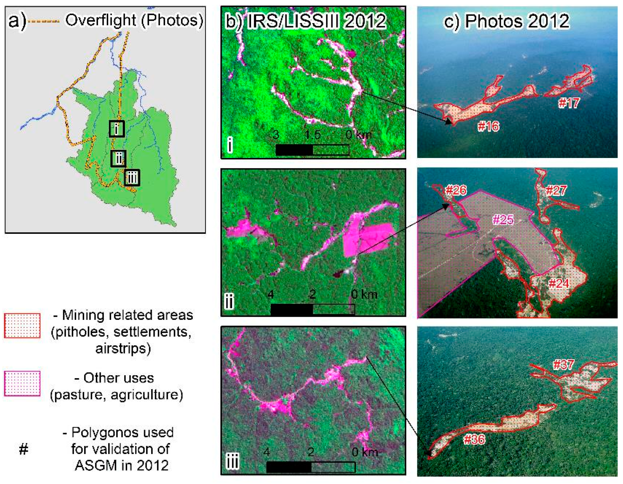
4.1. Validating Gold Mining Area in 2012
4.2. Gold Mining Area from 1973 to 2012
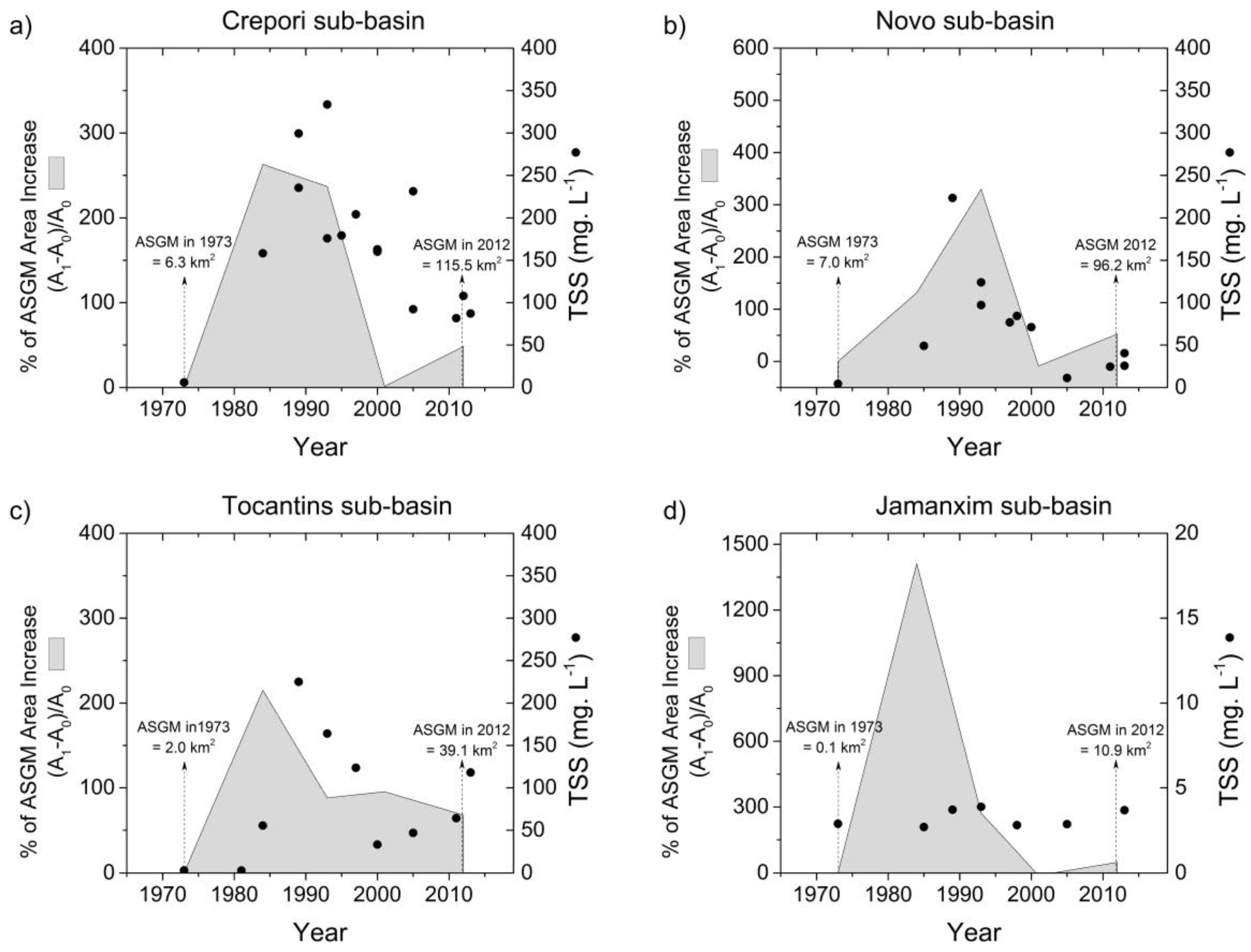
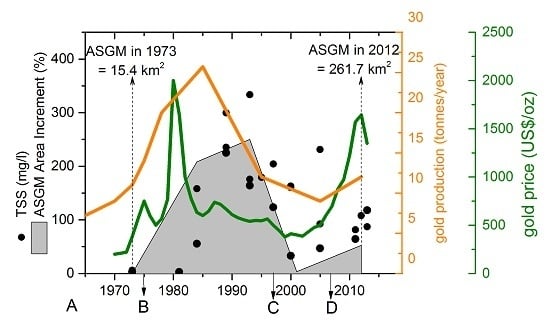
4.3. Historical Gold Mining Area and Water Siltation
4.4. Characterization and Distribution of Gold Mining Area: Proximity to Roads and Drainage Network, and Soil Types
5. Discussion
5.1. Satellite Imagery Time-Series for Estimation of Land Use and Water Siltation Change
5.2. Spatio-Temporal Analysiof ASGM and Water Siltation (1973–2012)
5.3. Management Recommendations and Future Research
6. Conclusions
Acknowledgments
Author Contributions
Conflicts of Interests
Abbreviations
| AERONET | Aerosol robotic network |
| AOT | Aerosol Optical Thickness |
| ASGM | Artisanal and Small-scale Gold Mining |
| DDV | Dense dark Vegetation |
| DN | Digital Number |
| FLAASH | Fast Line-of-sight Atmospheric Analysis of Hypercubes |
| IRS/LISSIII | Indian Remote Sensing/Linear Imaging Self Scanning Sensor |
| NIR | Near-Infrared |
| RGB | Red, Green, Blue |
| TOA | Top-of-Atmosphere |
| TSS | Total Suspended Solids |
References
- Veiga, M.M. Mercury in Artisanal Gold Mining in Latin America: Facts, Fantasies and Solutions; UNIDO: Vienna, Austria, 1997. [Google Scholar]
- Sousa, R.N.; Veiga, M.M. Using performance indicators to evaluate an environmental education program in artisanal gold mining communities in the Brazilian amazon. Ambio 2009, 38, 40–46. [Google Scholar] [CrossRef] [PubMed]
- Telmer, K.; Stapper, D. Evaluating and Monitoring Small Scale Gold Mining and Mercury Use: Building a Knowledge-Base with Satellite Imagery and Field Work; United Nations Industrial Development Organization: Victoria, BC, Canada, 2007. [Google Scholar]
- Silva, A.R. A Indústria Mineral no Pará; Alberto Rogério Benedito da Silva: Belém, Pará, Brazil, 2012. [Google Scholar]
- Fernandes, F.R.C.; Alamino, R.D.C.J.; Araújo, E.R. Recursos Minerais E Comunidade: Impactos Humanos, Socioambientais E Econômicos; CETEM/MCTI: Rio de Janeiro, Brazil, 2014. [Google Scholar]
- CPRM. Província Mineral do Tapajós: Geologia, Metalogenia E Mapa Previsional Para Ouro Em SIG. Available online: http://www.cprm.gov.br (accessed on 15 April 2013).
- Araújo Neto, H. Perfil do Ouro; Ministério de Minas e Energia: Brasília, Brazil, 2009. [Google Scholar]
- Rodrigues, R.M.; Mascarenhas, A.F.S.; Ichihara, A.H.; Souza, T.M.C. Estudo Dos Impactos Ambientais Decorrentes do Extrativismo Mineral E Poluição Mercurial no TAPAJÓS—Pré-Diagnóstico; CETEM/CNPq: Rio de Janeiro, Brazil, 1994. [Google Scholar]
- Roland, F.; Esteves, F.D. Effects of bauxite tailing on PAR attenuation in an amazonian crystalline water lake. Hydrobiologia 1998, 377, 1–7. [Google Scholar] [CrossRef]
- Tudesque, L.; Grenouillet, G.; Gevrey, M.; Khazraie, K.; Brosse, S. Influence of small-scale gold mining on french guiana streams: Are diatom assemblages valid disturbance sensors? Ecol. Indic. 2012, 14, 100–106. [Google Scholar] [CrossRef]
- Mol, J.H.; Ouboter, P.E. Downstream effects of erosion from small-scale gold mining on the instream habitat and fish community of a small neotropical rainforest stream. Conserv. Biol. 2004, 18, 201–214. [Google Scholar] [CrossRef]
- Lobo, F.L.; Costa, M.P.F.; Novo, E.M. Time-series analysis of landsat-MSS/TM/OLI images over Amazonian waters impacted by gold mining activities. Remote Sens. Environ. 2015, 157, 170–184. [Google Scholar] [CrossRef]
- Moran, M.S.; Bryant, R.; Thome, K.; Ni, W.; Nouvellon, Y.; Gonzalez-Dugo, M.P.; Qi, J.; Clarke, T.R. A refined empirical line approach for reflectance factor retrieval from landsat-5 TM and landsat-7 ETM+. Remote Sens. Environ. 2001, 78, 71–82. [Google Scholar] [CrossRef]
- Hadjimitsis, D.G.; Clayton, C. Assessment of temporal variations of water quality in inland water bodies using atmospheric corrected satellite remotely sensed image data. Environ. Monit. Assess. 2009, 159, 281–292. [Google Scholar] [CrossRef] [PubMed]
- Nery, M.A.C.; Silva, E.A.D. Balanço Mineral Brasileiro: Ouro; DNPM (Departamento Mineral de Produção Mineral): Brasília, Brazil, 2002. [Google Scholar]
- ICMBIO. Plano de Manejo-Floresta Nacional do Crepori-State of Pará; Resumo Executivo: Curitiba, Brazil, 2010. [Google Scholar]
- DGI/INPE. Divisão de Geração de Imagens. Available online: www.dgi.inpe.br (accessed on 1 May 2013).
- MMA. Geographical Data: I3geo. Available online: http://mapas.mma.gov.br/i3geo/datadownload.htm (accessed on 2 March 2013).
- SiBCS. Sistema Brasileiro de Classificação de Solos; Embrapa Solos: Rio de Janeiro, Brazil, 2006. [Google Scholar]
- CPRM. Geobank. 2012. Available online: http://geobank.cprm.gov.br (accessed on 15 March 2013). [Google Scholar]
- Coutinho, A.C.; Almeida, C.; Venturieri, A.; Esquerdo, J.C.D.M.; Silva, M. Uso e Cobertura da Terra nas Áreas Desflorestadas da Amazônia Legal: Terraclass 2008; EMBRAPA: Brasília, Brazil, 2013. [Google Scholar]
- INPE. Topodata: Banco de Dados Geomorfométricos do Brasil. Available online: http://www.dsr.inpe.br/topodata (accessed on 13 March 2013).
- Di Gregorio, A.; Jansen, L.J.M. Land Cover Classification System (LCCS). Classification Concepts and User Manual for Software Version 1.0; FAO/UNEP: Rome, Italy, 2000. [Google Scholar]
- Shimabukuro, Y.E.; Smith, J.A. The least-squares mixing models to generate fraction images derived from remote sensing multispectral data. IEEE Trans. Geosci. Remote Sens. 1991, 29, 16–20. [Google Scholar] [CrossRef]
- Chander, G.; Markham, B.L.; Helder, D.L. Summary of current radiometric calibration coefficients for landsat MSS, TM, ETM+, and EO-1 ALI sensors. Remote Sens. Environ. 2009, 113, 893–903. [Google Scholar] [CrossRef]
- NASA/GSFC. Aerosol Robotic Network (Aeronet). Available online: http://aeronet.gsfc.nasa.gov (accessed on 13 March 2013).
- Lu, D.; Mausel, P.; Brondizio, E.; Moran, E. Assessment of atmospheric correction methods for landsat TM data applicable to amazon basin lba research. Int. J. Remote Sens. 2002, 23, 2651–2671. [Google Scholar] [CrossRef]
- Lu, D.; Mausel, P.; Brondízio, E.; Moran, E. Relationships between forest stand parameters and landsat TM spectral responses in the Brazilian Amazon basin. For. Ecol. Manag. 2004, 198, 149–167. [Google Scholar] [CrossRef]
- Bezerra, O.; Veríssimo, A.; Uhl, C. Impactos da Garimpagem de Ouro na Amazônia Oriental; Imazon: Belém/PA, Portuguesa, 1998. [Google Scholar]
- Villas Bôas, R.C.; Beinhoff, C.; Silva, A.R. Mercury in Tapajos Basin; CNPq/CYTED: Rio de Janeiro, Brazil, 2001. [Google Scholar]
- Fearnside, P.M. Brazil’s Cuiabá-Santarém (BR-163) Highway: The environmental cost of paving a soybean corridor through the Amazon. Environ. Manag. 2007, 39, 601–614. [Google Scholar] [CrossRef] [PubMed]
- WRB/FAO. World Reference Base for Soil Resources, 1st ed.; International Soil Reference and Information Centre, ISRIC: Rome, Italy, 1998. [Google Scholar]
- Junk, W.J.; Piedade, M.T.F.; Schöngart, J.; Cohn-Haft, M.; Adeney, J.M.; Wittmann, F. A classification of major naturally-occurring amazonian lowland wetlands. Wetlands 2011, 31, 623–640. [Google Scholar] [CrossRef]
- DNPM. Sumário Mineral, 32. Available online: http://www.dnpm.gov.br (accessed on 5 April 2013).
- Browder, J.O. Public policy and deforestation in the Brazilian Amazon. In Public Policy and the Misuse of Forest Resources; Gillis, R.R.A.M., Ed.; Cambridge University Press: Cambridge, UK, 1988; pp. 247–298. [Google Scholar]
- Fearnside, P.M. Environmental destruction in the Brazilian Amazon. In The Future of Amazonia: Destruction or Sustainable Development; The Future of Amazonia: Macmillan, London, UK, 1990; pp. 179–225. [Google Scholar]
- Junk, W. General aspects of floodplain ecology with special reference to amazonian floodplains. In The Central Amazon Floodplain; Junk, W., Ed.; Springer: Berlin/Heidelberg, Germany, 1997; Volume 126, pp. 3–20. [Google Scholar]
- Telmer, K.; Costa, M.; Simões Angélica, R.; Araujo, E.S.; Maurice, Y. The source and fate of sediment and mercury in the Tapajós river, Pará, Brazilian Amazon: Ground- and space-based evidence. J. Environ. Manag. 2006, 81, 101–113. [Google Scholar] [CrossRef] [PubMed]
- Almeida, R.; Shimabukuro, Y.E. Digital processing of a landsat-tm time series for mapping and monitoring degraded areas caused by independent gold miners, Roraima State, Brazilian Amazon. Remote Sens. Environ. 2002, 79, 42–50. [Google Scholar] [CrossRef]
- Finer, M.; Novoa, S. Gold Mining Deforestation Continues to Expand in la Pampa (Madre de Dios, Peru). Available online: http://maaproject.org/2015/03/gold-mining-deforestation-expand-peruvian-amazon/ (accessed on 26 January 2016).
- Lobo, F.; Costa, M.P.F.; Novo, E.M.; Telmer, K.H. Effects of artisanal small-scale gold mining tailings on the underwater light field in the Tapajós River basin. Limnol. Oceanogr. 2016. in preparation. [Google Scholar]
- Alho, C.R.; Reis, R.; Aquino, P.U. Amazonian freshwater habitats experiencing environmental and socioeconomic threats affecting subsistence fisheries. Ambio 2015, 44, 412–425. [Google Scholar] [CrossRef] [PubMed]
- Biggs, T.W.; Dunne, T.; Martinelli, L.A. Natural controls and human impacts on stream nutrient concentrations in a deforested region of the Brazilian amazon basin. Biogeochemistry 2004, 68, 227–257. [Google Scholar] [CrossRef]
- Deegan, L.A.; Neill, C.; Haupert, C.L.; Ballester, M.V.R.; Krusche, A.V.; Victoria, R.L.; Thomas, S.M.; Moor, E. Amazon deforestation alters small stream structure, nitrogen biogeochemistry and connectivity to larger rivers. Biogeochemistry 2010, 105, 53–74. [Google Scholar] [CrossRef]
- Farella, N.; Lucotte, M.; Louchouarn, P.; Roulet, M. Deforestation modifying terrestrial organic transport in the rio tapajós, Brazilian amazon. Org. Geochem. 2001, 32, 1443–1458. [Google Scholar] [CrossRef]
- Telmer, K.H. The Effect of Changing Gold Prices on Artisanal Mining. Available online: http://artisanalgold.blogspot.ca (accessed on 2 April 2015).
- Shalash, S. Effects of sedimentation on the storage capacity of the high aswan dam reservoir. Hydrobiologia 1982, 91, 623–639. [Google Scholar] [CrossRef]
- Boudou, A.; Maury-Brachet, R.; Coquery, M.; Durrieu, G.; Cossa, D. Synergic effect of gold mining and damming on mercury contamination in fish. Environ. Sci. Technol. 2005, 39, 2448–2454. [Google Scholar] [CrossRef] [PubMed]
- Park, J.-G.; Curtis, R.L. Mercury distribution in sediments and bioaccumulation by fish in two oregon reservoirs: Point-source and nonpoint-source impacted systems. Arch. Environ. Contam. Toxicol. 1997, 33, 423–429. [Google Scholar] [CrossRef] [PubMed]
- Egler, S.G.; Rodrigues-Filho, S.; Villas-Bôas, R.C.; Beinhoff, C. Evaluation of mercury pollution in cultivated and wild plants from two small communities of the Tapajós Gold Mining Reserve, Pará State, Brazil. Sci. Total Environ. 2006, 368, 424–433. [Google Scholar] [CrossRef] [PubMed]


| Type of Data | Date | Description | Scale/Resolution | Source |
|---|---|---|---|---|
| Satellite Images (5 tiles per date, raster files) | August 1973 | Landsat 1 (MSS) | 80 m | DGI/INPE [17] |
| August 1984 | Landsat 5 (TM) | 30 m | ||
| September 1993 | Landsat 5 (TM) | 30 m | ||
| August 2001 | Landsat 5 (TM) | 30 m | ||
| September 2012 | IRS/LISSIII | 24 m | ||
| Aerial photos | May 2012 | Overflight performed in May 2012. Total of 40 photos and 70 mining polygons identified. | Shared by ICMBio | |
| Ancillary data | 2013 | River network | 1:50,000 | This study |
| (vector files) | 2010 | Water Bodies | 1:250,000 | [18] |
| 2010 | Roads | 1:250,000 | [18] | |
| 2006 | Soil | 1:250,000 | [19] | |
| 2012 | Mining sites and gold mining district | 1:250,000 | [20] | |
| Land use classification (vector files) | 2012 | TerraClass Project classified land-cover use for the Brazilian Amazon. | 1:50,000 | Available at CRA/INPE [21] |
| Historical TSS concentration (raster files) | 1973–2012 | Estimation of TSS concentration for Tapajós River Basin retrieved from satellite images. | 24–80 m | [12] |
| Classification of TerraClass-2012 | |||||
| Mining | Others Uses | Not Classified | Total | ||
| photos | Mining | 32 | 13 | 8 | 53 |
| Others uses | 3 | 14 | 0 | 17 | |
| Total | 35 | 27 | 8 | 70 | |
| Classification of MapASGM-2012 | |||||
| Mining | Other Uses | Not Classified | Total | ||
| photos | Mining | 50 | 3 | 0 | 53 |
| Other uses | 2 | 15 | 0 | 17 | |
| Total | 52 | 18 | 0 | 70 | |
| Mining Area (km2) | |||||
| Jamanxim | Crepori | Novo | Tocantins | Total | |
| 1973 | 0.1 | 6.3 | 7.0 | 2.0 | 15.4 |
| 1984 | 2.2 | 22.8 | 16.1 | 6.3 | 47.5 |
| 1993 | 8.2 | 77.0 | 69.2 | 11.9 | 166.3 |
| 2001 | 7.3 | 77.9 | 63.1 | 23.3 | 171.7 |
| 2012 | 10.9 | 115.5 | 96.2 | 39.1 | 261.7 |
| Other uses (km2) | |||||
| Jamanxim | Crepori | Novo | Tocantins | Total | |
| 1973 | 3.8 | 0.5 | 0.5 | 0.0 | 4.8 |
| 1984 | 185.1 | 11.7 | 10.2 | 2.9 | 209.9 |
| 1993 | 579.2 | 52.5 | 62.8 | 14.6 | 709.1 |
| 2001 | 1338.2 | 69.2 | 107.3 | 38.8 | 1553.5 |
| 2012 | 4212.0 | 192.2 | 365.7 | 54.9 | 4824.8 |
| Soil Type (World Reference Base, 1998) | Mining Area in 2012 (km2) |
|---|---|
| Acrisol | 1.2 |
| Arenosol | 2.6 |
| Gleysol | 53.7 |
| Ferrasol | 180.5 |
© 2016 by the authors; licensee MDPI, Basel, Switzerland. This article is an open access article distributed under the terms and conditions of the Creative Commons Attribution (CC-BY) license (http://creativecommons.org/licenses/by/4.0/).
Share and Cite
Lobo, F.D.L.; Costa, M.; Novo, E.M.L.d.M.; Telmer, K. Distribution of Artisanal and Small-Scale Gold Mining in the Tapajós River Basin (Brazilian Amazon) over the Past 40 Years and Relationship with Water Siltation. Remote Sens. 2016, 8, 579. https://doi.org/10.3390/rs8070579
Lobo FDL, Costa M, Novo EMLdM, Telmer K. Distribution of Artisanal and Small-Scale Gold Mining in the Tapajós River Basin (Brazilian Amazon) over the Past 40 Years and Relationship with Water Siltation. Remote Sensing. 2016; 8(7):579. https://doi.org/10.3390/rs8070579
Chicago/Turabian StyleLobo, Felipe De Lucia, Maycira Costa, Evlyn Márcia Leão de Moraes Novo, and Kevin Telmer. 2016. "Distribution of Artisanal and Small-Scale Gold Mining in the Tapajós River Basin (Brazilian Amazon) over the Past 40 Years and Relationship with Water Siltation" Remote Sensing 8, no. 7: 579. https://doi.org/10.3390/rs8070579
APA StyleLobo, F. D. L., Costa, M., Novo, E. M. L. d. M., & Telmer, K. (2016). Distribution of Artisanal and Small-Scale Gold Mining in the Tapajós River Basin (Brazilian Amazon) over the Past 40 Years and Relationship with Water Siltation. Remote Sensing, 8(7), 579. https://doi.org/10.3390/rs8070579


