
Citizen Observatories and the New Earth Observation Science

School of Geography, University of Leeds, Leeds LS2 9JT, UK
Remote Sens. 2017, 9(2), 153; https://doi.org/10.3390/rs9020153
Submission received: 2 August 2016
/
Revised: 29 January 2017
/
Accepted: 30 January 2017
/
Published: 15 February 2017
(This article belongs to the Special Issue Citizen Science and Earth Observation)
Abstract
:Earth observation is diversifying, and now includes new types of systems, such as citizen observatories, unmanned aerial vehicles and wireless sensor networks. However, the Copernicus Programme vision of a seamless chain from satellite data to usable information in the hands of decision makers is still largely unrealized, and remote sensing science lacks a conceptual framework to explain why. This paper reviews the literatures on citizen science, citizen observatories and conceptualization of remote sensing systems. It then proposes a Conceptual Framework for Earth Observation which can be used in a new Earth observation science to explain blockages in the chain from collecting data to disseminating information in any Earth observation system, including remote sensing systems. The framework differs from its predecessors by including social variables as well as technological and natural ones. It is used here, with evidence from successful citizen science projects, to compare the factors that are likely to influence the effectiveness of satellite remote sensing systems and citizen observatories. The paper finds that constraints on achieving the seamless “Copernicus Chain” are not solely technical, as assumed in the new Space Strategy for Europe, but include social constraints too. Achieving the Copernicus Chain will depend on the balance between: (a) the ‘forward’ momentum generated by the repetitive functioning of each component in the system, as a result of automatic operation or human institutions, and by the efficiency of interfaces between components; and (b) the ‘backward’ flow of information on the information needs of end users. Citizen observatories will face challenges in components which for satellite remote sensing systems are: (a) automatic or straightforward, e.g., sensor design and launch, data collection, and data products; and (b) also challenging, e.g., data processing. Since citizen observatories will rely even more on human institutions than remote sensing systems to achieve repetitive functioning, one of their greatest strengths—using a “crowd” of hand-held sensors to cover large areas—could also be one of their greatest weaknesses.
1. Introduction
The scope of Earth observation is diversifying. Over the last ten years, imaging sensors carried on satellites have continued to expand in number and type, and there have been three new developments. First, the potential for using Landsat to measure ecosystem area at global scale is finally being realized, facilitated by the free availability of Landsat data, and the development of computing technologies that can process thousands of images quickly and turn the continuous collection of global data by Landsat into streams of global information. Forty years since the launch of Landsat 1, and five years after Goward argued that we still have to “make the transition from experimental land remote sensing to operational monitoring” [1], the first global forest area maps based on Landsat data were published in 2012 and 2013 by teams headed by Townsend [2] and Hansen [3]. Second, sensors, and the sensing systems associated with them, have diversified in type. Automatic remote imaging sensors, carried on satellites, have been joined by new forms of remote imaging sensors, such as those carried on drones, or unmanned aerial vehicles (UAVs) [4], and by proximate non-imaging sensors on the ground, such as those in distributed wireless sensor networks (WSNs) [5]. Third, instead of leaving remote sensing in the hands of ‘experts’, new participatory approaches have emerged, in which non-scientists classify satellite images in Geo-Wiki studies [6], and either operate sensors or act as sensors themselves, in citizen observatories. These advances require a transition from remote sensing science to a new Earth observation science [7,8].
Yet are these new forms of Earth observation likely to be more effective in supplying information to end users than satellite remote sensing systems? For too long, remote sensing science has focused on technical evaluation of the properties and potential uses of the most recently launched sensors [9], and neglected the development of tools that would permit it to evaluate its own performance in transforming global data into information and knowledge at all scales from local to global, and in communicating the latter to those who need them. This requires tools that include social variables, instead of just technological and natural ones. According to the 19 year-old vision of the Global Monitoring for Environment and Security (GMES) Programme of the European Commission and the European Space Agency, now renamed the Copernicus Programme, satellites should merely be the first component in a seamless chain from Earth observation data to usable information in the hands of decision makers [10,11]. For those who only want a map of the environment in a relatively small area this goal may already be a reality. However, for many who need information at global scale to tackle major environmental problems apart from forest area change, such as desertification, biodiversity loss etc., the goal still remains elusive [12,13]. To understand the reasons for this problem, and find how to solve it, will require the development of conceptual frameworks or models that can analyse the contributions which Earth observation systems make “for society and in society”, to use the words of Mathieu and Desnos [7]. This is being recognized by leading space agencies, through such initiatives as “Satellites for Society” [14].
To address these issues this paper shows how an existing conceptual framework of remote sensing systems can be extended to encompass all Earth observation systems, and be used to evaluate the effectiveness with which data collected by sensors in these systems are converted into usable information in line with the Copernicus vision. The framework is tested on a new type of Earth observation system: the citizen (or citizens’) observatory. This is so new that a Google Scholar search in October 2016 only found four publications in international peer-reviewed journals whose titles include “citizen observatories” or “citizen observatory” (or their citizens’ equivalents), compared with 14,300 publications with “Landsat” in their titles. Two of the publications are derived from the same citizen observatory project—WeSenseIt [15,16]; the others come from two other projects—Citisense [17] and COBWEB [18].
The paper has two aims. First, to review the literatures on citizen science, citizen observatories and conceptualization of remote sensing systems, and relevant contributions in the information theory and science–policy communication literatures. Second, by building on these reviews, to show how the effectiveness of citizen observatories and satellite remote sensing systems can be evaluated using the same generic conceptual framework.
This paper has six main parts. Parts one to four review the literatures on citizen science, citizen observatories, conceptualization of remote sensing systems, and communicating information, to provide the material needed for the rest of the paper. Part five proposes a Conceptual Framework for Earth Observation. Part six uses this framework to compare the factors that influence the effectiveness of satellite remote sensing systems and citizen observatories.
2. Citizen Science
Citizen participation in scientific observation of the environment began with citizen science, which involves “partnerships between volunteers and scientists that answer real world questions” [19]. Citizen science has a long history of monitoring biodiversity, e.g., the Audubon Society’s Christmas Birdcount began in 1900, but it has expanded rapidly in the last seven years [20,21], catalysed by the emergence of “World Wide Web 2.0”, which incorporates “user generated content”, of which one form is “Volunteered Geographical Information” [22]. Citizen science has over a century of experience in involving and retaining citizens and controlling the quality of the data they collect, and this experience is summarized in this section (Table 1).
2.1. Involving and Retaining Citizens
Citizen science projects can be classified according to when citizens are first involved in them. In contributory projects, scientists design the projects and citizens merely contribute data [23]. In co-created projects, on the other hand, citizens are full partners from design to dissemination. In between are collaborative projects, in which citizens help to analyse data, refine project design, and disseminate outputs [24].
A review of experiences reported in key studies of citizen science shows that people are motivated to participate in it by a desire to: (a) contribute to science [25]; (b) belong to a community with similar interests; (c) collect, contribute and publish their data openly online; (d) learn more about the subject of the project and about familiar places; (e) enjoy themselves have fun; (f) make new discoveries by analysing their data themselves [23,26]; (g) undertake new activities as part of existing recreational activities; (h) experiment with new ways of collecting data; and (i) gain recognition and other personal benefits [21].
Effective projects have websites whose design is consistent with these motivating factors, and with factors that maximize recruitment and retention of volunteers. Ideally, therefore, websites: (a) are user-friendly, so that registering as a volunteer is easy [23]; (b) are compatible with communication media with which volunteers are comfortable [27]; (c) keep data entry forms simple; (d) distinguish between the needs of different users, e.g., by customizing data entry software for advanced users, newly joined volunteers and young people [23]; (e) are compatible with user skills, e.g., instead of users just being asked to positively identify a tree species, even though they may make mistakes, they could also report the specific attributes of organisms so that others can use these data to confirm the species [28]; (f) give volunteers continual feedback about scientific outcomes derived from their contributions [25]; and (g) enable volunteers to analyse and share their data online, consistent with open data protocols [29]. For example, the eBird project attracted 2 million observations in its first two years, but it received 3 million observations in just one month after its website was upgraded to allow volunteers to analyse and visualize for their own purposes the data they collect, and share their data with others [30]. People often volunteer in response to stories in the media, but website software must be in place before a project is announced, or staff could be overwhelmed by offers. Thus, the Galaxy Zoo astronomy project recruited 160,000 volunteers, and just one appeal on a prime-time news programme on BBC radio in the UK in 2007 led to tens of thousands of responses [31].
2.2. Controlling Data Quality and Accuracy
Some scientists are sceptical about the reliability of data that citizen scientists collect, and the suitability of these data for integration with scientific data and information. Experience shows that accuracy levels vary between projects, but positional accuracy of data is higher than the accuracy of estimates of quantitative attributes, e.g., tree height, and of semantic attributes, e.g., tree species [32]. Accuracy is greater if volunteers are trained beforehand [25], and use technologies that comprise “standardized monitoring protocols, designed by professionals and then field tested by citizen scientists working under realistic conditions” [32].
Project websites can therefore promote greater accuracy if they: (a) educate volunteers, e.g., through online tutorials; (b) include more succinct information on spatial concepts and species identification etc. through interactive online help; (c) automatically evaluate data quality and provide feedback to volunteers, e.g., by visualizing accuracy and uncertainty; (d) allow specialists to check classifications by volunteers, e.g., by using the attributes of organisms entered by volunteers to confirm their species; (e) exchange data with other databases, to facilitate this checking process; (f) have tools to support analysis, modelling, metadata and decision making; and (g) generate reports and statistics [23].
3. Citizen Observatories
Citizen observatories can be viewed as the next phase in the evolution of citizen science. A citizen observatory is defined here as any use of Earth observation technology in which citizens collect data and are empowered by the information generated from these data to participate in environmental management.
3.1. Origins and Features
According to the European Commission, where the concept originated, a citizen (or citizens’) observatory should use “innovative earth observation technologies (in particular those based on use of mobile telephony)… [and] community-based environmental monitoring, data collection, interpretation and information delivery systems; empower communities with the capability to monitor and report on their environment; and enable communities to access the information they need to make decisions in an understandable and readily usable form” [33].
Citizen observatories have at least four distinctive features [33]:
- Bidirectional information flows, i.e., “citizens are recipients of information but also important providers”.
- New citizen functions, e.g., “the public should be given the means to aggregate, combine and generally reuse information according to their various needs”.
- Support for multi-scalar governance, e.g., “participation in assessing the success of European Union (EU) environment policies”.
- Complementarity, e.g., “the potential to enormously expand in situ monitoring capability, and ... limit the charge on the public purse...”
3.2. Citizen Observatories and Citizen Science
Citizen observatories differ from citizen science in two main ways:
- The information which they generate must, by definition, directly benefit citizens and society generally, rather than science alone, as in much conventional citizen science. Data collected by citizen scientists have so far had relatively few practical applications [26].
- They will be organizationally more complex than previous citizen science projects, most of which were only contributory projects [23]. Owing to the greater participation of citizens from an early stage, most citizen observatories are likely to fall within the categories of co-created projects or collaborative projects (see Section 2.1).
A recent review of the citizen observatory literature actually confused citizen observatories with citizen science and so aggregated both types of projects. Yet its list of clusters of best practices showed how citizen observatories can build on key features of effective citizen science projects, e.g., “data aggregation, feedback from observations, gamification, participatory data collection, provide technology, provide training material, measure motivation, real time visualization, and set common protocols for observers”, by adding practices more suited to citizen observatories, e.g., “co–creation, environmental campaigns in public spaces, identify stakeholders and their motivations, interest based observatories, involve decision makers, open data for engagement, and opportunistic data collection” [21].
3.3. Relations with Other Participatory Approaches
Citizen participation in geographical information science is already widespread, and citizen observatories can be related to three other approaches in this participatory landscape:
- Public Participation Geographical Information Systems (PPGIS) are also co-created and collaborative [34]. However, PPGIS tend to operate at fairly low spatial scales, whereas citizen observatories can operate at a wider range of scales, and to do this they must use more sophisticated involvement strategies.
- PPGIS fits into the category of community science (or “science for the people”) [34] since it mainly collects and analyses data for local needs, not scientific research [23]. However, citizen observatories will involve research for and by the people, and so can bridge the dichotomy between community science and citizen science, fill gaps in scientific and lay knowledges, and contribute to policies at all spatial scales.
- Citizen observatories are a new form of crowdsourcing [35], which assumes that either “a group can solve a problem more effectively than an expert, despite the group’s lack of relevant expertise”, or “that information obtained from a crowd of many observers is likely to be closer to the truth than information obtained from one observer” [36]. They differ from a well-established form of crowdsourcing in Earth observation called Geo-Wiki, in which citizens substitute for professional scientists in classifying satellite data on land cover [6].
3.4. Interoperability with Other Initiatives
Earth observation as a whole will benefit from exploiting synergies between citizen observatories and existing remotely sensed and ground datasets. The latter can calibrate and validate citizen data in return for using them to extend their own ground measurements at low cost [37]. Each observatory will identify networks and databases with which it would benefit from establishing links, but two relevant international initiatives are:
- The Global Earth Observation System of Systems (GEOSS) framework of the Group on Earth Observations. This has a vision of an integrated approach to comprehensive monitoring of the Earth System. It facilitates the collection and sharing of data and information [38], and has defined principles of interoperability, public accessibility, network distribution and capacity building [39,40]. Citizen observatory data and information could be listed in the GEOSS Registry and Clearinghouse and accessed through its Portal.
- The Infrastructure for Spatial Information in Europe (INSPIRE) Directive, which provides a practical framework for realizing the vision of a “knowledge society” through interoperable geo-spatial information. Citizen science is mentioned in various INSPIRE guidelines, such as those for specifying data on species distributions [41].
Collaboration and interoperability will require the development of common vocabularies, definitions, classifications and other standards, e.g., on metadata, data fusion and data visualization; and agreement on common exploitation, dissemination and communication strategies. Standards that facilitate implementation of the new Open Data paradigm include the Five Star Ranking Scale: information is freely available on the web in any format and with an open licence (1 Star); data are structured and machine readable (2 Star); data are machine readable and in non-proprietary formats (3 Star); data can be located by users through a Uniform Resource Locator (URL) link (4 Star); and data are linked to other data and have all the other features too (5 Star) [42].
3.5. Citizen Observatory Projects Funded by the European Commission
Through its Framework 7 Programme, and as a contribution to the GEOSS, in 2012 the European Commission funded five pilot citizen observatory projects to monitor: biosphere reserves (COBWEB) [18]; urban air quality (CITI-SENSE) [17,43,44]; nuisances from odours (OMNISCIENTIS) [45]; floods and droughts (WeSenseIt) [15,16,46]; and marine water quality (Citclops) [47,48].
These projects illustrate the various ways in which mobile devices may be used in citizen observatories to collect data and/or transmit data to local and/or central project websites. In COBWEB, citizens use smartphones to input data on species distributions using standard data entry forms and background maps. These data are sent to the project website, together with data on the weather and other types of variables measured by wireless sensor networks (WSNs) [18]. In OMNISCIENTIS, citizens use smartphones to input data on their perceptions of odours linked to a pig farm and industrial site, and these are complemented by data measured by WSNs [45]. WeSenseIt also uses WSNs to measure various stages of the water cycle, while citizens can use smartphones to input data on river levels, as measured by gauge boards whose bar-codes are scanned to reference the data [46]. CITI-SENSE combines the collection of data on urban air quality by fixed sensors in WSNs with data collected by citizens, e.g., by using smartphones to measure levels of particulates [44]. In Citclops, citizens use smartphones to monitor water quality, in terms of pollutant concentration, algal density etc., by measuring such parameters as the colour of water and levels of fluorescence [47].
Priorities for effective citizen observatories identified in planning these pilot projects [33,43,49,50] include:
- Employ user-friendly technologies.
- Control data quality and accuracy.
- Design observatories so they can collaborate with other initiatives.
- Design information outputs to support environmental management.
The first three priorities (Table 2) correspond to requirements already identified for effective citizen science projects (Table 1). The last priority is specific to citizen observatories and their initial implementation.
In 2016 the European Commission’s Horizon 2020 Programme funded some full scale citizen observatory projects. These observatories will: map land use and land cover (LANDSENSE and SCENT); monitor urban and rural environmental indicators linked to planning issues (Ground Truth 2.0); and engage small farmers to validate soil moisture measurements by satellites in return for information on crops and watering (GROW) [51]. The real test of these projects, and the earlier pilot projects, will be whether they inspire citizens to establish observatories themselves to meet their own information needs.
3.6. Conceptualizations of Citizen Observatories
Initial conceptualizations of citizen observatories have been of two main kinds. First, taxonomic conceptualizations, which classify particular features and are common in the early stages of a new field of enquiry. Citizen observatories have been:
- Situated within the Open Data paradigm because, unlike citizen science, collected data are not solely analysed by a central scientific team [52].
Second, two early attempts to transcend taxonomy have led to the identification of a mixture of features and processes in which citizen observatories have been:
- Described by nine “dimensions”: (i) sensors and transmission; (ii) stakeholders; (iii) area of application; (iv) purpose of citizen observatory; (v) system integration; (vi) measurement; (vii) implementation; (viii) communications paradigm; and (ix) citizen participation in governance processes [16]. Associated with each dimension is a range of features. While the list of dimensions is helpful, it does not provide a comprehensive generic description of how citizen observatories operate. Thus, dimensions (iii) and (iv) are goals specific to each observatory; and dimension (ix) refers to whether and how citizens can participate in decision-making after they receive information from citizen observatories. Other dimensions are generic, e.g., dimension (i) distinguishes between physical sensors and social sensors; dimension (vi) distinguishes between objective measurement and subjective reporting; dimension (vii) refers to how an observatory is established organizationally, i.e., either bottom-up or top-down; dimension (viii) distinguishes between unidirectional and interactive communication; and dimension (ii) refers to potential end users.
- Described by four “aspects”: (i) collaborative participation; (ii) two data layers, in which a “hard layer” is generated by sensors and a “soft layer” by citizens; (iii) a bidirectional (top-down and bottom-up) approach; and (iv) bidirectional interactive communication [17]. This approach is also partial, and while in its present form it merely identifies ideal norms it could be converted into a generic set of variables.
This review refines the earlier list of functionalities that effective citizen observatories need [33], in addition to those required for successful citizen science projects, as follows (Table 3):
- Interactive communication and information flows.
- Full citizen involvement in co-creating observatories or collaborating in them.
- Supporting the active participation of citizens in multi-scalar environmental management through good communication links with decision-makers and other stakeholders.
- Complementarity and interoperability with other Earth observation systems and other data networks through open data protocols.
4. Conceptualizations of Remote Sensing Systems
Remote sensing is “the science and art of obtaining information about an object, area, or phenomenon through the analysis of data acquired by a device that is not in contact with the object, area or phenomenon under investigation” [54]. In an alternative definition, remote sensing involves “inferring the order in the properties and distributions of matter and energy in the scene from the set of measurements comprising the image… [and]…scene inference.. then ... becomes a problem of model inversion in which the order in the scene is reconstructed from the image and the remote sensing model” [55].
Academic study of any phenomenon is often framed by a conceptual framework which identifies the boundaries of the phenomenon, the variables involved in it, processes which link the variables, and normative trends or functional patterns that characterize the system of which the phenomenon is the visible representation. It can explain phenomena, generate hypotheses or research questions about them, and identify key variables that should be the focus of empirical study to advance understanding of phenomena. In the natural sciences such frameworks often form the basis for mathematical models, but in the social sciences qualitative frameworks are more common.
The two definitions of remote sensing listed above were devised within different conceptual frameworks. The first definition was based on a framework that focused on a chain of activities that collect data and process these into information. The second definition focused on how processes in the natural world are imaged and then reconstructed from images.
A remote sensing system encompasses all the stages and processes involved in remote sensing, from collecting data remotely to delivering usable information to those who need it. Given the economic importance of remote sensing and the number of active remote sensing scientists, conceptualization of how remote sensing systems convert raw data into usable information is still remarkably limited. In 1979 Lillesand and Kiefer [54] published a simple framework which linked eight generic components of remote sensing systems (Figure 1):
- Energy sources.
- The atmosphere.
- Earth surface features.
- Sensing systems.
- Data products.
- Interpretation and analysis (includes ground truth data collection).
- Information products.
- Users.
This framework was used to identify the content of an ideal system, e.g., a uniform energy source; a non-interfering atmosphere; a series of unique energy-matter interactions at the Earth’s surface; a super sensor; a real-time data handling system; and multiple data users.
This in turn provided the basis for a comparison with the typical features of real systems, e.g., the energy source is not uniform; atmospheric interference occurs; energy matter interactions lead to spectral ambiguity; sensors have specific limits on spectral sensitivity and spatial resolution; “the capability of sensors to generate data far exceeds the current capacity to [process] these data” into information; and “the ‘data’ generated by remote sensing procedures become information only if and when someone understands their generation, knows how to interpret them and knows how best to use them” [54].
A later framework, proposed by Strahler et al., only included three of these components: the atmosphere, earth surface features and sensors [55].
Both conceptualizations are good at describing the individual components of remote sensing systems, and how they should ideally fit together in a sequence. Where they are less good is in explaining why remote sensing systems do not live up to expectations. This is because, with the exception of data interpreters and users in the first framework [54], they are confined to environmental and technological variables. So they can explain deviations from the ideal that are connected with these variables, e.g., atmospheric interference, but they cannot explain why and how socio-economic constraints limit the amount of information derived from remote sensing data and its transmission to potential end users.
Subsequent models have had a narrower focus (Table 4). Thus, Phinn portrayed how remote sensing data are used to generate a map to meet demand for information [56]:
- Specify the output information required for a particular site.
- Specify the scene model, e.g., by the choice of spectral bands and the spatial and temporal resolutions of the sensor which are most appropriate for studying the site.
- Identify available remote sensing data.
- Specify and evaluate suitable remote sensing data.
- Select the techniques required to analyse remote sensing data to provide required information.
The last of these stages leads to output information, but end users are not mentioned even though their needs are identified. A simpler “image chain approach”, devised by Schott [57], includes only input, processing and output display stages. The last stage is only ‘understood’ to include the end-user, while the processing stage is recognized to be the weak link in the chain.
Lack of progress made since the 1980s in conceptualizing remote sensing systems could be explained by a comment by Lippitt and Stow [9], that: “remote sensing has been primarily an engineering exercise focused on the design, implementation and testing of hardware and software systems to permit Earth observation and mapping. The discipline’s primary epistemology, academic culture and mode of instruction focuses on what is resolvable at what precision using a given remote sensing approach.”
5. Communicating Information
5.1. Modelling Information Flows within the Scientific Community
A recent response to this conceptualization gap in the remote sensing literature has been to use information theory to model how information derived from remote sensing data matches demand for information. Based on a leading communication model, which identifies a “message source, an encoder, a transmission channel, an interpreter and a message destination” [58], Lippitt et al. devised a Remote Sensing Communication Model (RSCM) in which the source is the reality of environmental conditions, the encoder is the sensor, the data transmitted by the sensor are the message, the channel constitutes the data transmission and distribution system, the remote sensing analyst is the interpreter, and the end-user corresponds to the destination. They then used a later information theory model, which relates information value to three communication levels [59], to characterize the overall effectiveness of the process. Level A requires that original data must be technically appropriate to the information required; Level B that data are processed into information appropriate to the needs of a particular user; and Level C that the information is delivered to the user in the format that the user needs to take a decision [60].
One advantage of the RSCM is that feedback loops link end users to various stages in the process, so that those who supply information are aware of the information which end users require. Another advantage, which makes the RSCM a major step forward over earlier qualitative conceptualizations (e.g., 54), is that the model is specified in terms of quantitative variables, which makes it perfect for evaluating the time taken to deliver time-sensitive information, e.g., on natural or human-made hazards. On the other hand, a limitation necessary for such quantification is that the model is confined to environmental and technological variables, and assumes that the information derived from a remotely sensed image can supply all the information required by end users. The feasibility of the RSCM has been demonstrated by using it to estimate the time required to deliver to the US Forest Service information on a forest fire which it has to tackle. However, this study is a special case, since it essentially evaluates how quickly one branch of an organization can supply information to another branch of the same organization. It assumes that the information supplier has access to contemporaneous images of the fire—or to an airplane which can collect such images—and that staff are already in place and have the time free to process the images [61].
To further advance research in this important field would require addressing the more general problem of meeting demand for geo-spatial information, typified in a time-sensitive context by demand from an international agency for information on an earthquake or volcanic eruption in some remote part of the world. This is also influenced by social constraints on remote sensing systems, and to explain these constraints would therefore require a framework that included social variables and processes too. It would also have to relax assumptions that: (a) remote sensing scientists can always supply all the information required by decision-makers; (b) images are always available on demand for particular areas (or can be collected on a bespoke basis); (c) information is only needed at relatively local scales; and (d) human beings always take decisions in a purely rational way, whereas social scientists have for a long time treated decision-making as only “boundedly rational” [62].
In an alternative conceptualization, the Knowledge Exchange Chain Framework, the collection and processing of remote sensing data into information on ecosystem area occupy just the first two cycles in a longer chain, in which different types of data from various remote sensing and ground sources are processed into information of increasing complexity on the multiple attributes of ecosystems in a given area (Figure 2). Scientists from other disciplines who occupy later cycles in the chain need digital information on ecosystem area distribution (derived from remote sensing data) so they can add their own information on other ecosystem attributes, such as biodiversity or carbon density, which they have usually obtained from ground measurements. (They often lack image processing skills themselves). They can then use the resulting maps of the distributions of multiple ecosystem attributes to produce information to satisfy demand from decision makers. Such demand may be for information ranging in scale from local to international, and could encompass, for example, priority areas for conservation based on the distribution of a particular set of threatened species (which would require a map with two attributes), or the distribution of forests with high carbon density and high biodiversity (three attributes). A key constraint on the production of such multiple attribute maps is the limited availability of digital information on ecosystem area derived from remote sensing data [13]. The present paper examines in detail the reasons for the critical blockage in the first two cycles of this knowledge exchange chain.
5.2. Modelling Communication of Scientific Information and Knowledge to Decision Makers
Communication of science-based information to non-scientists normally falls under the general category of science–policy communication studies. Models in this field do not assume that scientists can deliver information in a language which is immediately understandable by decision-makers. Instead, they explain the processes by which information is translated from scientific languages into lay languages. According to one popular model, called the boundary organization model, ideal communication occurs when: (a) information flows in two directions between the scientific and decision making communities, so that scientists can understand what information decision-makers require, and decision-makers can understand what information scientists can supply; and (b) a small group containing representatives from these communities—called a “boundary organization”—negotiates the translation of scientific knowledge from scientific language into lay language. The model explains constraints on translation, one of which is that it tends to optimize the salience, legitimacy and credibility of the translated knowledge [63]. Knowledge is salient if it is relevant to the needs of end users; legitimate if its production is perceived to be fair and unbiased and respects the different values, beliefs and interests of stakeholders; and credible if it is based on adequate scientific evidence and arguments. This model incorporates power, which is missing in information theory approaches [60], since decisions on optimization often privilege political salience and legitimacy in complex ways over scientific credibility [64].
Studies of science–policy communication often focus on communication to government policy makers. Yet research in political science suggests that since 1990 there has been a gradual shift from the conventional governmental style of governing, dominated by national governments, toward a new “governance” style, which is multi-scalar, multidirectional instead of top-down, and gives greater scope for non-governmental organizations, and civil society generally, to participate [65]. Under this style, instead of governments steering societies, societies are now effectively “self-steering”, and depend on complex interactions between governments and civil society, which involve networking links; multi-level repeated practices, or “institutions” [66]; and new types of interactive policy instruments [67].
This shift has two implications for citizen observatories:
- Now that actors at all scales can contribute to policy formulation and implementation, information is needed at all these scales too. Citizen observatories are therefore emerging at the perfect time to give individual citizens, informal groups, and more formalized non-governmental organizations the information they need to be effective in the new governance.
- Governments used to rely heavily on scientific advice, which they had the power to elevate above other forms of knowledge [63]. However, the declining power of governments limits their ability to elevate scientific knowledge in this way, and so the latter must now compete with knowledge produced by citizen observatories and other civil society groups.
Models of science–policy communication can be used to analyse the channelling of outputs to decision makers at various points along a knowledge exchange chain. However, a key strategic question is whether to go further, and include the use of information for decision making within conceptual frameworks constructed to evaluate the effectiveness of Earth observation. This “inclusive approach” is adopted in one conceptualization of citizen observatories, which uses the democracy cube method [68] to characterize citizen participation in environmental management by three dimensions: (a) authority and power; (b) communication and decision-making mode; and (c) participants [16]. However, this method has limitations, for while the “participants” dimension has a continuous spectrum from national organizations to individual citizens, the other two dimensions are less continuous. A counter argument is that since political scientists already model decision making using a variety of methods [69], it would be more pragmatic instead to establish the boundary of conceptual frameworks of citizen observatories (and other Earth observation systems) at the point where information reaches decision makers, and use existing political science frameworks to model how decisions are taken with the help of this information. Consequently, the transmission of information to decision makers would be within the scope of a new Earth observation science, but how that information is then used in decision making would be excluded. One advantage of this approach is that scientists can choose the existing decision-making framework most appropriate to the subject of their study, instead of applying the same framework to all subjects.
6. A Conceptual Framework for Earth Observation
The next two sections bring together the findings of the literature reviews in previous sections, to show how factors influencing the effectiveness of all Earth observation systems can be evaluated using the same generic conceptual framework.
Earth observation science involves the scientific study of the methods which can be used to observe Planet Earth, the processes by which planetary data are converted into usable information, and the factors that influence these methods and processes. An Earth observation system encompasses all the stages and processes involved in constructing knowledge about all or part of Planet Earth, from designing and launching a sensor to delivering usable information or knowledge to those who need it.
The Conceptual Framework for Earth Observation (CFEO) described here consists of 12 components (Figure 3):
- Sensor design and launch.
- Energy source.
- Earth surface features.
- The atmosphere.
- Sensor features.
- Data collection.
- Data products (including storage).
- Sensor and data selection.
- Data processing (including pre-processing, ground truth data collection and validation).
- Information products (including storage).
- Information dissemination (1, 2, 3….).
- End users (1, 2, 3….).
As is common in the design of conceptual frameworks, some features of this framework display continuity with, and extend, a previous framework—here the one devised by Lillesand and Kiefer (Figure 1) [54]. However, the CFEO differs from that framework in seven ways:
- It contains four new components: sensor design and launch, which is needed for any sensor; data collection, which depends on the operational features of a sensor, as well as its design features; sensor and data selection, which specifies which data from which sensor are used, and can combine data from multiple sensors if necessary; and information dissemination, which identifies the channels by which information products are communicated to end users.
- It does not just apply to remote sensing systems that comprise imaging sensors, some of which are novel, such as those carried on unmanned aerial vehicles (UAVs). It also applies to non-imaging sensors, such as those in citizen observatories and those linked in wireless sensor networks (WSNs). Sensors may either be near (or proximate) to the phenomenon they monitor, as with citizen observatories, or remote from it, as with satellites.
- It can describe a single Earth observation system, e.g., a satellite remote sensing system, or a combination of systems, e.g., a satellite remote sensing system complemented by a UAV remote sensing system.
- It can evaluate systems of any physical length, from those in which the sensor and its data archive are both distant from end users, to those in which they are adjacent to end users.
- Links between components are not just unidirectional, but can be bidirectional, or even multidirectional with multiple sequential paths through the system. This is consistent with the emphasis on interactive bidirectional communication in two earlier conceptualizations of citizen observatories [16,17].
- It does not assume that all data collected by sensors are converted into usable information in the hands of end users, or that information products inevitably reach end users. Instead, it aims to explain why demand for information is not always satisfied by the supply of information.
- It does not assume that components are simply stages in a sequence. Instead, it models the operation of each component, and interfaces between components.
To do this, the framework is based on five principles:
- Technological and social components are interchangeable, and all but two components, i.e., Earth surface features and the atmosphere, can be classified as automatic, semi-automatic or discretionary. (The energy source component can be automatic, e.g., the Sun, or discretionary, e.g., LiDAR (light detection and ranging) [70].) When operation is semi-automatic or discretionary the component includes a human element, and this is represented by two synergistic elements: the repeated practices, or institutions, of an individual actor or group, and their world view or discourse (see below). Together these determine whether or not this particular component functions on a repeated basis and how it turns inputs from the previous component into outputs. Actors will not repeat practices if this makes no sense in the context of their world view. Thus, the world view of one scientist may focus on studying the operation of a remote sensor, while that of another scientist may focus on studying the processes of Planet Earth. Giving each component the possibility of including a human element allows for the general case in which all components not describing natural features can be populated by actors from different scientific disciplines or from non-scientific backgrounds. Remote sensing systems in which many of the components are automated then become a special case.Repetitive human behaviour has been studied in recent decades by various social sciences disciplines [71]. Institutions are defined as “enduring regularities of human action in situations structured by rules, norms and shared strategies, as well as by the physical world” [66]. Formal institutions comply with formal rules, e.g., the rules of evidence of a scientific discipline, while informal institutions are everyday practices that can become accepted norms [71]. Using Ostrom’s concept of multi-level institutions [72], day to day operational institutions are nested in higher level collective choice institutions, e.g., those of a given scientific discipline, and these in turn may be nested, to varying degrees, in constitutional choice institutions, e.g., those of governments and United Nations organizations. In citizen observatories, human institutions can substitute for technologies that are automated in remote sensing systems. Whether or not actors choose to repeat practices depends on many factors. According to Hajer [73] these factors include the world view, or discourse, of the actor, since the reproduction of an actor’s discourse and their institutions are synergistic: in his definition, a discourse is “a specific ensemble of ideas, concepts, and categorizations that are produced, reproduced and transformed in a particular set of practices and through which meaning is given to physical and social realities”.
- Technological and social components may be characterized by their capacity as well as by their frequency of operation. Capacity can refer to the processing power of computers, the size of databases, and the human skills of actors, e.g., in processing satellite images or collecting data in citizen observatories.
- Various components may be combined according to the particular group responsible for them. For example, in a satellite remote sensing system, a satellite agency would typically be responsible for all components from sensor design and launch to data products, but other groups would be responsible for the remaining components. In other Earth observation systems, such as citizen observatories, group responsibilities would be more complex. This principle enables communication interfaces between different groups to be easily delineated. For the sake of generality, Figure 3 only shows communication between adjacent components. When the framework is used in practice, the groups responsible for sets of components, and the communication interfaces between them, would be overlaid onto the component sequence in a way that best suits the particular case.
- Communication interfaces between different groups may be of various kinds, but each will be structured within some form of institutional framework. For example:
- A market-based interface would be framed within institutions that allow for private property rights, so that a satellite agency can sell the images that it collects to those who wish to process them into information.
- An open data interface would be framed within institutions that allow for open access rights. Thus, a satellite agency could distribute its images free of charge to remote sensing scientists, who might then make processed information available free of charge over the World Wide Web to other scientists or to non-scientific end users.
- The effectiveness of open data communication interfaces between different groups may be evaluated using the boundary organization model, which uses interactive communication as a norm, and specifies the constraints on the translation of information and knowledge from one language to another and between groups with different institutions. “Language” is used here in a general way to refer to: (i) the form of communication, e.g., words, numbers, pictures etc.; and (ii) the medium of communication, e.g., paper, video, digital format, Web-based etc. (as emphasized in Level C of the Remote Sensing Communication Model [60]). For convenience, only one information dissemination component and one end users component are represented in Figure 3. This allows the figure to represent the first three cycles in the knowledge exchange chain shown in Figure 2. In practice, however, it may be expanded to include any number of dissemination interfaces with scientists from other disciplines or with decision-makers.
The CFEO generates two principal hypotheses:
- A fully effective Earth observation system, which has a seamless Copernicus Chain from component 1 (sensor design and launch), to component 12 (end users), is characterized by perfect interactiveness (or bidirectionality) throughout the system. This is consistent with one of the conditions already identified for effective citizen observatories [16,17].
- The actual degree of effectiveness/interactiveness of an Earth observation system depends on the balance between: (a) the forward momentum generated by the repetitive functioning of each component, resulting from automatic operation or human institutions, and by the effectiveness of forward communication interfaces; and (b) the backward flow of information on the information needs of end users, which depends on the effectiveness of backward communication interfaces. The more components operate repetitively, and the more components are included within the reach of forward and backward flows of information, the more effective a system will be.
The CFEO has a diagnostic element which explains the disparity between data collection and satisfying demand for information in an Earth observation system by five types of blockages linked to the operation of components or interfaces between them:
- Natural, such as the prolonged presence of high cloud cover in the atmosphere which obscures an area of the planet from remote sensors and inhibits data collection.
- Technological, which includes the degradation of a sensor and operational limitations, both of which restrict its temporal resolution of data collection for a particular area of the planet; and limitations on computing power which can restrict, for example, the number of satellite images which can be processed into information in a single day.
- Institutional. When the operation of a component is semi-automatic or discretionary it depends on a human element, and if this fails to ensure repetitive functioning, i.e., institutionalization, then the component becomes ineffective. This can cause a blockage in the Earth observation system and in the wider knowledge exchange chain associated with it. Sometimes the operational institutions of a particular group that correspond to its repetitive functioning are restricted by the collective choice institutions of the discipline or wider group to which it belongs, and even by constitutional choice institutions.
- Economic, in which, for example, the cost of satellite images restricts the number of images purchased and hence the spatial scale at which images are processed into information.
- Communication. When information is passed from one scientific discipline to another, or from scientists to non-scientists, its utility can be degraded by forward blockages, linked to poor translation from the originator’s language to the receiver’s language. In this case “language” refers to both the form of communication and the medium of communication (see above). The form and medium of communication chosen by suppliers of information will be influenced by their collective choice institutions, e.g., many satellite remote sensing scientists in the past chose to satisfy the common institutions of their discipline by communicating their outputs in written papers that gained them recognition by other remote sensing scientists, rather than as digital outputs that could be used by scientists from other disciplines. The reverse flow of information from those who need information to those who can supply it can be interrupted by backward blockages. Even if information on demand passes beyond the information dissemination component(s) it is likely to experience a critical blockage at the first discretionary component after that.
7. The Effectiveness of Satellite Remote Sensing Systems and Citizen Observatories
7.1. Introduction
This section uses the Conceptual Framework for Earth Observation (CFEO) to compare the factors which influence the effectiveness of satellite remote sensing systems and citizen observatories. The two particular cases evaluated here are the satellite monitoring of tropical forest area change, for which historical empirical information is available, and a potential European citizen tree observatory. Where information is available, in peer-reviewed journal papers or reports to the European Commission, the second case study draws on experiences in the pilot citizen observatory projects reviewed in Section 3.5. However, many of these experiences are still to be analysed and published. So to fill crucial gaps in empirical information, especially for the data processing and information dissemination components, this case study relies heavily on lessons learned from the review of the citizen science literature in Section 2.
7.2. Evaluation
Each component in the framework is now discussed in turn.
a. Sensor design and launch. The launch of satellite sensors by rockets is a discretionary technological process, but after a single launch sensors operate automatically. The high cost of multiple launches of photographic sensors on airplane platforms was historically a key reason for the infrequency of national forest surveys, and the arrival of satellite sensors removed this critical economic blockage at the start of aerial remote sensing systems [74]. However, satellite sensors are still vulnerable to technological blockages, e.g., the rocket could fail to put the satellite into orbit, or the sensor could fail to operate once launched.
Sensor design is a social process and often follows prior consultation with particular groups of end users. Landsat 1, launched in 1972, included a Multi-Spectral Scanner (MSS) designed to meet the needs of end users for information on particular Earth resources, including agricultural and forest resources. The 79 m ground resolution of the MSS was sufficient to distinguish forest from the small 1 hectare clearances found in tropical deforestation [74]. Sometimes, unexpected uses are discovered after launch by groups of end users that were not consulted before design. For example, the Advanced Very High Resolution Radiometer (AVHRR) satellite sensor of the US National Oceanographic and Atmospheric Administration, with a spatial resolution of 4 km, was originally intended for meteorological monitoring, but was later found to be useful for monitoring vegetation at continental scale. The spectral resolution of later AVHRR sensors was modified to improve their utility in this respect [75,76].
The launching of citizen observatories is a discretionary social process. Great skill is required to motivate a sufficiently large group of volunteers and, in contrast to satellite remote sensing, to sustain this motivation to ensure repetitive monitoring (see below). If motivation cannot be sustained there is the prospect of an institutional blockage. Research in citizen science suggests that people are likely to be motivated to join a citizen observatory by the prospect of: (a) contributing to science; (b) collecting, contributing and publishing their data openly online; (c) learning more about the subject of the project or about familiar places; (d) enjoying themselves having fun; (e) making new discoveries by analysing their data themselves; (f) enhancing existing recreational activities; (g) experimenting with new ways of collecting data; (h) gaining recognition and other personal benefits; and (i) belonging to a community with similar interests (Table 1). All but the last of these factors are consistent with the existence of synergies between people’s practices and their discourses. The last factor is consistent with Hajer’s proposal that groups tend to cluster according to their discourses [73], as is another factor specific to citizen observatories: a desire to produce information to support the interests of a group which aims to participate in environmental management, e.g., by contributing to a planning inquiry, campaigning to conserve a local area etc. Citizen observatory websites should reinforce these motivating factors, and also make it easy to register as a volunteer.
Motivation will be even higher if citizens are involved from the start in designing observatories and their sensors [24]. Citizen observatories add new options to the menu of available remote sensors, and citizens can use their discretion in deciding which features their mobile and fixed sensors should have, to monitor ecosystems, air, water or other phenomena. The case study in this section complements observatories already established by referring to a European citizen tree observatory designed to contribute to the need of the World Conservation Union for a global map of the distribution of the individual trees of each species [77]. This could be used to identify species with a high priority for conservation, map changes in species distributions due to global climate change, and monitor the spread of pests and diseases.
b. Energy source. Many satellite remote imaging sensors, such as Landsat, rely on the passive sensing of radiation in the visible and infra-red parts of the spectrum, and this is the case for a citizen tree observatory too. So both of the case studies in this section benefit from an automatic energy source: the Sun. Other satellite remote imaging sensors, such as Radarsat, are active instruments which emit microwave radiation and measure the reflected radiation.
c. Earth surface features. Some surveys are only intended to produce information on horizontal features, such as the distribution of ecosystems. Other surveys are more ambitious, and aim to produce information in three dimensions, which also requires the mapping of vertical features, such as the height of forest stands.
d. The atmosphere. The atmosphere distorts radiation reflected from Earth surface features before it reaches passive remote imaging sensors, and so images must be pre-processed to correct for this and other distortions. Citizen observatories focusing on proximate measurement should experience no atmospheric distortion. The atmosphere, in the form of high cloud cover, represents a major natural blockage in the humid tropics by obscuring forest from passive satellite imaging sensors. This blockage can be removed by the use of active remote imaging sensors and other strategies described below.
e. Sensor features. Sensors may be divided into a number of different types. Imaging sensors produce images of a scene, whereas non-imaging sensors detect other features, e.g., the concentration of a gas. Some imaging sensors are passive, as they detect reflected radiation emitted from an energy source, such as the sun, while others are active, since they are the origin of the radiation whose reflectance they measure. Sensors can also be distinguished by the platforms on which they are carried. Remote sensors are carried on platforms at various heights above the ground, e.g., by satellites, airplanes or unmanned aerial vehicles (UAVs), but proximate sensors are situated near the feature they detect, and are fixed, as in distributed wireless sensor networks (WSNs), or mobile, as in smartphones. Human beings act as platforms when they carry smartphone sensors, and also as sensors when they identify species with their eyes and use smartphones merely to enter their observations and transmit them to a local or central computer database.
Features of remote imaging sensors include the spatial, temporal and spectral resolution at which data are collected; the sensor family; the type of platform used; and platform height. These features are optimized in the design process to meet the needs of particular end users. Passive sensors on satellites have long been used to map horizontal features, while active radar and Lidar sensors can map vertical features too. The utility of Landsat for forest monitoring was further enhanced when a 30 m resolution Thematic Mapper (TM] instrument was introduced on Landsat 4 in 1982. The launch of the Moderate Resolution Imaging Spectroradiometer (MODIS) sensor in 1999 provided a sensor with a spatial resolution of 250 m–1 km that is intermediate between that of Landsat and AVHRR sensors. Its temporal resolution of 1–2 days is also much less than that of Landsat (18 days) and therefore has advantages for producing low cloud cover images. These features operate automatically once the satellite has been launched, but are subject to technological blockages resulting from instrument or power failures.
Citizen observatories focusing on ecosystems can use smartphones to map the horizontal distribution of highly dispersed small objects, e.g., the multiple characteristics of large numbers of individual trees, including their species, by a human sensor interacting with data entry forms and species keys provided in smartphone software. They can also measure vertical features using sensors and software on smartphones, e.g., the Relasphone smartphone App can be used to estimate tree height [78]. Individual trees can also be identified by very high resolution [VHR] satellite sensors, whose images are now freely available on the Google Earth website. Yet citizen observatories still have an advantage for mapping some characteristics, such as species [18], which exceed even the resolving power of VHR images.
The variety of sensors used in citizen observatories make them useful for monitoring more than just ecosystems. Thus, in the Framework 7 pilot citizen observatory projects reviewed in Section 3.5, software Apps loaded onto smartphones can turn them into sensors capable of monitoring water quality [47]; air pollution [43]; and human perceptions [45]. Several pilot projects combine hand-held sensors with wireless sensor networks (WSNs) too. The choice of features incorporated into the design of any citizen observatory is suited to end user needs and the phenomenon being monitored, but effectiveness is subject to institutional blockages, e.g., when species are identified incorrectly, and this needs to be countered by quality control mechanisms. Citizen observatory sensors are also vulnerable to technological blockages linked to their hardware and software.
f. Data collection. Satellite imaging sensors collect data automatically, though data collection by aerial imaging sensors on airplane or UAV platforms is discretionary.
Data collection by citizen observatories is also discretionary. This can be an advantage, e.g., human operators could choose to only selectively map the distribution of all trees of the same species which are dead or suffering from a disease or pest. On the other hand, continuous monitoring is possible only if many highly motivated individuals are strongly encouraged to repeat their practices sufficiently often, e.g., every week, or every day if necessary, so their actions become institutionalized. Citizen observatories are therefore always vulnerable to institutional blockages if individual behaviour is not regular, e.g., even the most enthusiastic volunteer can miss some monitoring days due to illness. Repeated monitoring will be promoted by citizen observatory websites, and custom software carried on smartphones, which are: (a) user friendly, and so make it simple to enter data because they are compatible with user skills and with communication media with which volunteers are comfortable; and (b) bidirectional and interactive, in giving citizens continual feedback about the outcomes of their contributions, and enabling them to communicate with observatory managers who coordinate data processing (Table 1). Technological blockages are also possible.
g. Data products. Satellite remote sensors automatically package a huge amount of data into discrete data products, or images, which are transmitted to receiving stations and then to one or more archives, from where users can download them. These satellite images are usually ranked by operating companies for quality, influenced by natural blockages, such as high cloud cover. Some companies produce composite images in which all parts of a scene are of the highest possible quality, at the expense of temporal simultaneity, e.g., as in the Global Land Survey series of Landsat images released by the US Geological Survey.
In any citizen observatory, sophisticated website technologies will be needed to combine and integrate a large number of data inputs from many highly dispersed human sensors into data packages that are as easy to manipulate as satellite images. These technologies will need to be customized to fit the focus of the observatory, and any limitations in the resulting software would constitute a technological blockage. Another discretionary element will be required to control quality, and will depend on such features as: (a) the use of technologies which comprise well designed and field tested methods; (b) training volunteers beforehand, or ‘on the job’ through software on smartphones and observatory websites; and (c) software that automatically evaluates data quality and provides feedback to citizens, and allows observatory managers to manually check data entered by volunteers (Table 1). The last two features reflect the CFEO’s interactive principle. Including a manual checking facility will be important for a citizen tree observatory that aims to identify tree species. It could compare the species identification with the multiple attributes of the particular tree that were entered independently by the human operator (see Section 2.2). The failure of manual checking would constitute an institutional blockage.
h. Sensor and data selection. In a given remote sensing survey one or more sensors are selected, based on relevant criteria. Among these criteria are the spatial, temporal or spectral resolutions of sensors which are appropriate to the type of information required. The discretionary combination of data products from multiple sensors has long been common—even basic supervised classification of satellite images requires human observers to collect ground truth data [54]—and in the 21st Century techniques for “fusing” data from different sensors are becoming increasingly sophisticated [79]. Some sensors are preferred to others in certain parts of the world, e.g., since tropical moist forests are routinely obscured from Landsat sensors by natural blockages due to high cloud cover, large-area surveys have also made use of satellite or airborne radar and LIDAR sensors, which can penetrate cloud, or lower resolution optical satellite sensors, such as AVHRR or MODIS, whose higher frequency increases the chance of collecting low cloud cover images.
Before Landsat images became free of charge in 2008, and helped to make possible wall-to-wall annual Landsat-based estimates of tropical forest change [3], this component could also represent an economic blockage to large-area surveys, and preference was given to low resolution AVHRR and MODIS images which have always been freely available. For example, one estimate of the rate of deforestation in the humid tropics in the 1990s was produced by first using 1 km resolution AVHRR images to map forest area and identify deforestation ‘hot-spot’ areas, and then taking samples of Landsat TM images in these areas to estimate the rate of deforestation [80]. A later study relied on 8 km AVHRR images to map changes in tropical forest cover in the 1980s and 1990s, and only used Landsat TM images for classification and validation [81]. In a third study, tropical moist forest area was mapped using 0.5 km resolution MODIS images, and then a 0.2% sample of medium resolution images was used to estimate the deforestation rate between 2000 and 2005 [82]. MODIS images with 250 m resolution are now the basis of the Terra-i system for mapping tropical forest area change every 16 days [83].
Economic blockages can be linked to institutional blockages, and Landsat is an interesting example of how institutional changes have influenced economic blockages to the availability of satellite images. The first set of changes arose through changes in government constitutional choice institutions. In 1985, operation of Landsat was transferred to the private sector, following a Presidential Directive and Act of Congress. The need to recover costs under the new system led to a huge increase in the price of each image, and understandably demand declined sharply. In 1992, another Act of Congress required that in future Landsat images should be made available at the lowest possible cost. In 2008, as a result of another change in the data distribution policy of NASA and the US Geological Survey, Landsat images were made available free of charge [84]. However, for some time before this, the formal institutions which framed the pricing of Landsat were countered by new informal scientific institutions established by the Global Land Cover Facility at the University of Maryland. It made certain digital Landsat images available free of charge [85] and actually became the leading supplier of Landsat images.
Citizen observatories have fewer options in this component because they have already decided in the design component which sensors their observatories should contain, and in the data collection component which features of these sensors should be used. Yet the pilot COBWEB, CITI-SENSE, OMNISCIENTIS and WeSenseIt observatories all complement their mobile sensors with fixed sensors in wireless sensor networks (WSNs) [18,43,45,46], and a citizen tree observatory could make use of VHR images which map individual trees and are freely available on the Google Earth website.
i. Data-processing. The use of satellite sensors for operational monitoring of the planet in general, and tropical forests in particular, is constrained by the fact although collection of data is automatic, the processing of these data into information is often semi-automatic. Two key issues are:
i. Frequency. The frequency of information production on tropical forest area change has historically been highest at lower spatial scales or lower spatial resolution. This results from a mixture of technological blockages, e.g., a lack of capacity for processing large numbers of images in a reasonable time; economic blockages, e.g., the cost of purchasing and processing large numbers of images; and institutional blockages, e.g., the collective choice (disciplinary) institutions of remote sensing, which allow research to be recognized as constituting an advance if it merely tests sensors at low spatial scales [9]. Only in recent years have remote sensing scientists processed satellite data on tropical forest area change at large scales at a frequency matching the temporal resolution of data collection, e.g., Terra-i monitors tropical vegetation change every 16 days based on automatic processing of low (250 m) resolution MODIS images [83], while the Global Land Analysis and Discovery (GLAD) group at the University of Maryland mapped changes in global forest cover on an annual basis between 2000 and 2012 [3] by semi-automatic processing of Landsat TM images that had previously been automatically pre-processed on Google Earth Engine. Terra-I, GLAD and the Global Land Cover Facility (GLCF) group at the University of Maryland, which produced the first global forest cover map based on Landsat imagery [2], have all experienced no economic blockages as a result of the free availability of Landsat and MODIS images. They have overcome technological blockages in different ways: the GLCF group uses an in-house computing facility; the GLAD group processes data in the Cloud using Google Earth Engine; Terra-i processes images using a distributed network of server computers based at its member organizations; and all use different computer algorithms to process data.
ii. Quality. The quality of data processing has generally lagged behind the potential offered by available satellite data, as a result of economic, technological and institutional blockages, e.g., estimates were produced by either combining low resolution images and samples of medium resolution images [80,82], or by relying solely on low resolution images [81]. In developing countries, visual processing of satellite data in photographic format is often still favoured over digital processing for national forest surveys, because it costs less, is considered more convenient and appropriate where human capital is limited, and also reproduces longstanding institutions developed for aerial photogrammetry.
The type, quality and frequency of data processing in citizen observatories are likely to be at least as discretionary as those for remote sensing systems. The lack of existing collective choice and operational institutions in this new field has both advantages and disadvantages. As in the best citizen science projects, repeated practices, and hence the institutionalization of processing, will be encouraged by: (i) collaboration in groups; and (ii) the ability of members of the citizen observatory to either use its information outputs themselves to participate in environmental management or to support the participation of a related group. According to the citizen science literature, the frequency of processing is likely to be promoted by website software which: (i) enables citizens to process their own data for their own purposes; (ii) generates reports and statistics; (iii) has tools to support analysis, modelling and decision making and (iv) can exchange data with other databases (Table 1). Experience in citizen science indicates that accuracy is promoted by good practice in data collection summarized under the data products component above. Information already available on data processing in the pilot observatories reviewed in Section 3.5 suggests that many of them comply with these best practice guidelines for frequency and quality. However, data processing in citizen observatories will still be vulnerable to technological and institutional blockages.
j. Information products. The form, media and frequency of information products derived from data processing can be a serious obstacle to information dissemination if they do not match what end users demand. In the past, information products on tropical forest area change derived from satellite images have been subject to institutional and communication blockages, since the collective choice institutions and discourse of remote sensing science have privileged operational institutions which: (i) produce information in paper format, e.g., in academic journals, rather than in digital format which, if shared with fellow scientists, would allow the latter to add digital information on other environmental attributes to the original map; and (ii) dissemination on a once-only, non-repeated, basis. The situation is now changing, but sharing large-area digital information derived from satellite data via the Worldwide Web is still only a recent innovation, with the work of the Global Land Analysis and Discovery group [86] and Terra-i [83] being examples of good practice (see below).
Citizen observatories generally, and a citizen tree observatory in particular, should be more flexible in the form, media and frequency of their information products, as a result of being more aware of end user needs, and sharing “a common language” by having similar discourses. So the number of institutional and communication blockages should be fewer than in a satellite remote sensing system. However, insufficient information is available in peer-reviewed journal papers or reports to the European Commission to allow a full appraisal of information products from the pilot observatories reviewed in Section 3.5.
k. Information dissemination. To realize the Copernicus Chain ideal, remote sensing scientists should disseminate information either directly to decision makers, or to fellow scientists from different disciplines who can add content (e.g., by adding information on other ecosystem attributes) before they themselves communicate information to decision makers. In the past, for tropical forest area monitoring this has not happened at large spatial scales as often as desired, as a result of institutional and communication blockages. More specifically, there were disparities: (a) between the collective choice institutions and language of remote sensing science and those of other scientific disciplines; and (b) between the collective choice institutions and language of science generally and the institutions and languages of decision makers.
Various attempts have been made to overcome blockages in disseminating digital information produced by remote sensing scientists to non-remote sensing scientists. Recent advances in the collective choice institutions of science as a whole are promoting the depositing of digital outputs of projects, e.g., on the websites of universities and research councils, but these may be difficult even for fellow scientists to find, and will be all but invisible to non-scientists. Astronomers have solved this problem by establishing virtual observatories in which all available digital information is listed in registries, the scientific digital equivalent of ‘Yellow Pages’ [87], and this approach provides a model that environmental scientists can emulate. It is now routine to attach large datasets to journal papers as supplementary information, but the arrival of journals that solely publish digital data is making searching easier. The easiest communication option is for remote sensing scientists to disseminate information to other scientists directly, and the Global Land Analysis and Discovery group [86] and Terra-i [83] are examples of best practice in disseminating digital information through their own university websites.
Communicating information on tropical forest area change to non-scientists is more challenging. However, both the Global Land Analysis and Discovery group and Terra-i have come up with the ingenious solution of using a civil society website as an intermediary. Both disseminate their digital information on the website of a public-facing think tank, the World Resources Institute. Forest monitoring is one of WRI’s specialist areas, and its Global Forest Watch website [88] gives the public access to digital forest information by using tools that are more user-friendly than those on a typical university website. A similar approach is taken by the Centre for International Forest Research in disseminating its global wetlands map [89].
Citizen observatories should have lower institutional and communication blockages to disseminating information than those in satellite remote sensing systems. The desire of citizens to participate in environmental management should give them an incentive to collect data, process the data into information, and then disseminate this information widely. Flows of information between end users and the different components of citizen observatories in Figure 3 could approach the bidirectional ideal, owing to the similarity of civil society languages and institutions. This should also allow feedback on end user needs to permeate down the chain of an Earth observation system close to its first component—sensor design and launch. All the pilot observatories reviewed in Section 3.5 have established user-friendly web portals to disseminate the data they have collected and information derived from them, and a future citizen tree observatory would follow their good examples.
l. End users. Potential end users of the outputs of satellite remote sensing systems and citizen observatories include remote sensing scientists, scientists from other disciplines, governments, intergovernmental organizations, other stakeholder groups, citizens and non-governmental organizations. Each group has a different set of information needs and a different language in which these needs should be supplied.
The information needs of various groups of end users were taken into account in the design of the first Landsat satellite. At that time the importance of studying and managing global environmental change was hardly realized, but this satellite, and its successors, have been collecting global data for over 40 years and so difficulties in converting these data into global information, e.g., on tropical forest area change, were not inherent in the design but resulted from other factors discussed here. Now that the blockages to communicating digital information on tropical forest area change (and global forest area change generally) have been removed this means that scientists and other end users can use these maps as base maps for assembling more complex maps of changes in the multiple attributes of forest ecosystems, such as biodiversity, carbon density etc. Hopefully, the examples of pioneering groups of remote sensing scientists in this field will be emulated by others concerned with monitoring non-forest ecosystems so that a truly comprehensive global base map of ecosystem area change at medium (Landsat) resolution will soon become available.
For end users, global maps of ecosystem area change are the starting point for constructing the information they need, because it means that they can select information for whatever part of the world is of concern to them—however small or large this may be. Without such maps they cannot make a start, because most of them lack the skills of remote sensing scientists. If the scientific community does not continue to expand its monitoring in this way, then citizen observatories offer an alternative mechanism for citizens to satisfy their information needs.
7.3. Synthesis
This section has demonstrated the relevance of the CFEO by applying it to historical experience in monitoring tropical forest area change using satellite remote sensing systems, and comparing this with the likely characteristics of a citizen tree observatory. It is important to be specific when applying the CFEO because the characteristics of each Earth observation system will be different. This comparison shows that, despite the many automated components in a satellite remote sensing system, a seamless “Copernicus Chain” between the first and last loss components can still be interrupted by discretionary components and a variety of blockages, most of which in this case were close to the end of the chain nearest to end users (Table 5). The utility of citizen observatories is still to be demonstrated, but they differ from a typical satellite remote sensing system in relying heavily on discretionary human behaviour for repetitive functioning. In some ways this is an advantage over highly automated Earth observation systems, but it leaves them vulnerable to institutional blockages.
8. Discussion
8.1. Significance
This paper has shown how extending the scope of an existing conceptual framework of remote sensing systems, especially by adding a social dimension, can greatly increase its power to explain factors which limit the effectiveness of a satellite remote sensing system, or indeed any other Earth observation system, such as a citizen observatory.
The framework identifies the components of any Earth observation system in a generic manner, and to enhance this analysis the different types of sensors used in Earth observation systems are distinguished. A crucial advance in the new Conceptual Framework for Earth Observation (CFEO) is in generalizing from automatic operation of the components of an Earth observation system to semi-automatic and discretionary operation, which depends on the reproduction of human institutions. The reliability of these repeated practices, and the efficiency of interfaces between individual components, determine the forward momentum in an Earth observation system, and the backward flow of information on the information needs of end-users. It is proposed that the balance between forward momentum and backward flow determines the actual effectiveness of an Earth observation system, relative to the seamless chain from data collection to usable information which is the ideal of the Copernicus Programme. The CFEO contains a diagnostic element which enables blockages of different kinds to be identified.
8.2. Limitations
While there are a lot of empirical data on the design and implementation of remote sensing systems, and the behaviour of remote sensing scientists, this is not the case for citizen observatories, which were only conceived a few years ago. This paper used what information was already available in formal reports on the performance of the earliest pilot observatories, but it had to rely heavily on a review of previous research into citizen science for indications about factors that will contribute to their effectiveness. The review of available research on citizen observatories in Section 3 distinguished between them and citizen science projects.
The analysis here of the likely effectiveness of citizen observatories is therefore limited by the small amount of empirical information that could be used. It is also constrained by limitations in the CFEO. Ideally, conceptualizations of remote sensing systems would have developed in parallel with remote sensing science over the last 40 years, but this is not the case, and so the CFEO had to build on a framework first proposed in 1979 [54].
8.3. Future Research
There is great scope to use the CFEO in its present form to evaluate other Earth observation systems, especially those centred on unmanned aerial vehicles (UAVs) and wireless sensor networks (WSNs). Experience in these evaluations should contribute to refinements in the CFEO and to better conceptual frameworks for Earth observation systems.
Future publication of more in-depth reports on the implementation of the first pilot citizen observatories will provide scope for more detailed evaluations of these observatories than is possible here. These reports will also be of help in implementing the full-scale citizen observatories launched in 2016.
9. Conclusions
This paper has proposed a comprehensive Conceptual Framework for Earth Observation (CFEO), comprising twelve components, which advances theoretical development in the new Earth observation science. The paper has shown how the CFEO can be used to evaluate both citizen observatories and satellite remote sensing systems.
The CFEO fills an important gap in the literature on conceptualization of remote sensing systems, which was identified in the review of this literature in Section 4. The literature on citizen science is now fairly mature, after more than a century of experience. In contrast, the literature on citizen observatories is still embryonic. The review in Section 3 of studies already published shows that some of the factors that are likely to determine the effectiveness of citizen observatories will coincide with those found in citizen science. However, there is much to discover about what happens to the generic citizen science system when it is ‘opened out’ to give more autonomy to citizens and place greater responsibility on them for communicating their findings to other civil society groups. The relationship between citizens and professional scientists also changes greatly in citizen observatories. Future research will hopefully shed light on this changing relationship and on the nature of the optimum role of professional scientists in citizen observatories.
This paper has found that citizen observatories will face implementation challenges in components which for satellite remote sensing systems are: (a) automatic or straightforward, namely sensor design and launch, data collection, and data products; and (b) also challenging, namely data processing. Citizen observatories should be more effective in two other components, information products and information dissemination, since they have institutions and languages in common with civil society end users, and should understand their information needs. However, in implementing the open data paradigm they could face further challenges in ensuring security and privacy [28].
A crucial insight provided by the CFEO is that achieving the Copernicus Programme ideal of a seamless chain from data collection to information dissemination depends on the balance achieved in each Earth observation system between: (a) the ‘forward’ momentum generated by the repetitive functioning of each component, as a result of automatic operation or human institutions, and by the efficiency of interfaces between components; and (b) the ‘backward’ flow of information on the information needs of end users. The more components that operate repetitively, and the more components are included within the reach of forward and backward flows of information, the more effective an Earth observation system will be. The European Space Agency now provides a model of best practice in the comprehensiveness of its consultation procedures on the design of new satellites, so ideal backward flow is achievable.
This insight has wider policy implications. In contrast to an assumption in the new “Space Strategy for Europe” [90], we have found that the constraints on achieving the seamless “Copernicus Chain” from Earth observation data to usable information are not solely technical. Institutional constraints are important too. Even though many components in satellite remote sensing systems are automated their effectiveness is still limited by institutional constraints that impede repetitive functioning in such crucial components as data processing and information dissemination. Citizen observatories will have fewer automated components and therefore rely even more on human institutions to achieve repetitive functioning. This means that the feature of citizen observatories which is one of their greatest strengths, namely using a “crowd” of hand-held sensors to cover large areas in a discretionary way, could also be one of their greatest potential weaknesses, since it relies on large numbers of people reproducing the common institutions of their citizen observatory. However strong the institutions of a group may be, they cannot be as reliable as an automated sensor.
So the sustainability of citizen observatories is increased if they have access to a range of data sources, as exemplified by the pilot citizen observatory projects reviewed in Section 3.5 which operate wireless sensor networks (WSNs) in parallel with the use of hand-held sensors. On the other hand, a smaller group of citizens could also monitor a substantial area by: using a Geo-Wiki approach and analysing very high-resolution satellite images that are easily available on the Google Earth website; collecting bespoke images by flying unmanned aerial vehicles (UAVs); or analysing the readings of WSNs. It is possible that a team of scientists could use UAVs and WSNs to collect data on some, but not all, of the environmental features that citizen observatories can monitor. Indeed, they are already doing so [4,5]. However, what distinguishes citizen observatories is that they can monitor at larger scales than are usually feasible for scientists using UAVs and WSNs.
The reliability of the findings reported in this paper is constrained by the novelty of citizen observatories and the limitations of the CFEO. The publication of more papers in peer reviewed journals that evaluate the experiences of the five pilot citizen observatory projects will provide a greater evidence base to analyse their effectiveness in future research. The CFEO could also be used to undertake in-depth evaluations of Earth observation systems based on UAVs and WSNs. The fact that the CFEO had to be based on one of the earliest conceptualizations of remote sensing systems, dating back to 1979 [54], because later conceptualizations could not equal it in scope and explanatory power, does not reflect well on remote sensing science. Hopefully, this paper will persuade others to devise even better conceptual frameworks and lead to a major growth in this field.
What is encouraging is that the diversification of Earth observation is driving a transition from remote sensing science to a new Earth observation science. As a science situated in society, rather than outside it, advances in Earth observation science will be judged, as is any leading science today, not only by how much its research pushes back the empirical and methodological frontiers, but also by its impacts on society, which in this case involves realizing the “Copernicus Chain”, and by being able to evaluate its own impact on society. The CFEO, and its successors, can be used to evaluate the realization of both these goals. Another imperative is to devise a proper theory of the construction of global environmental knowledge, so that now we have finally started to measure the planet properly we shall be able to use these measurements to construct reliable information and knowledge at global scale.
Acknowledgments
This research was supported by the Science and Technology Facilities Council (STFC) under grant ST/K006738/1. The author also thanks anonymous peer reviewers for helpful suggestions.
Conflicts of Interest
The author declares no conflicts of interest.
References
- Goward, S.N. Land remote sensing in the 21st Century, geotechnologies in service to human societies. Geofocus 2007, 7, 1–4. [Google Scholar]
- Townshend, J.R.; Masek, J.G.; Huang, C.; Vermote, E.F.; Gao, F.; Channan, S. Global characterization and monitoring of forest cover using Landsat data: Opportunities and challenges. Int. J. Digit. Earth 2012, 5, 373–397. [Google Scholar] [CrossRef]
- Hansen, M.C.; Potapov, P.V.; Moore, R.; Hancher, M.; Turubanova, S.A.; Tyukavina, A.; Thau, D.; Stehman, S.V.; Goetz, S.J.; Loveland, T.R.; et al. High-resolution global maps of 21st-Century forest cover change. Science 2013, 342, 850–853. [Google Scholar] [CrossRef] [PubMed]
- Crommelinck, S.; Bennett, R.; Gerke, M.; Nex, F.; Yang, M.Y.; Vosselman, G. Review of automatic feature extraction from high-resolution optical sensor data for UAV-based cadastral mapping. Remote Sens. 2016, 8, 689. [Google Scholar] [CrossRef]
- Bouabdellah, K.; Noureddine, H.; Larbi, S. Using wireless sensor networks for reliable forest fires detection. Procedia Comput. Sci. 2013, 19, 794–801. [Google Scholar] [CrossRef]
- Fritz, S.; McCallum, I.; Schill, C.; Perger, C.; See, L.; Schepaschenko, D.; van der Velde, M.; Kraxner, F.; Obersteiner, M. Geo-Wiki: An online platform for improving global land cover. Environ. Model. Softw. 2012, 31, 110–123. [Google Scholar] [CrossRef]
- Mathieu, P.P.; Desnos, Y.L. Enabling the transition towards Earth Observation Science 2.0. In Proceedings of the EGU General Assembly 2015, Vienna, Austria, 12–17 April 2015.
- Wagner, W.; Fröhlich, J.; Wotawa, G.; Stowasser, R.; Staudinger, M.; Hoffmann, C.; Walli, A.; Federspiel, C.; Aspetsberger, M.; Atzberger, C.; et al. Addressing grand challenges in Earth observation science: The Earth Observation Data Centre for Water Resources Monitoring. ISPRS Ann. Photogramm. Remote Sens. Spat. Inf. Sci. 2014. [Google Scholar] [CrossRef]
- Lippitt, C.D.; Stow, D.A. Remote sensing theory and time-sensitive information. In Time-Sensitive Remote Sensing; Lippitt, C.D., Stow, D.A., Clarke, K.C., Eds.; Springer: Berlin, Germany, 2015; pp. 1–10. [Google Scholar]
- Achache, J. From GMES to NOE: A European network for the management of the environment. Space Policy 2001, 17, 97–101. [Google Scholar] [CrossRef]
- European Commission. Proposal for a Regulation of the European Parliament and of the Council, Establishing the Copernicus Programme and Repealing Regulation (EU). No 911/2010. COM(2013) 312 Final; European Commission: Brussels, Belgium, 2013. [Google Scholar]
- Grainger, A. Measuring the planet to fill terrestrial data gaps. P. Natl. Acad. Sci. USA 2009, 106, 20557–20558. [Google Scholar] [CrossRef] [PubMed]
- Grainger, A. Uncertainty in constructing global knowledge about tropical forests. Prog. Phys. Geogr. 2010, 34, 811–844. [Google Scholar] [CrossRef]
- Eurisy. Satellites for Society: Reporting on Operational Uses of Satellite-Based Services in the Public Sector; Eurisy: Paris, France, 2016. [Google Scholar]
- Wehn, U.; Evers, J. The social innovation potential of ICT-enabled citizen observatories to increase eParticipation in local flood risk management. Technol. Soc. 2015, 42, 187–198. [Google Scholar] [CrossRef]
- Wehn, U.; Rusca, M.; Evers, J.; Lanfranchi, V. Participation in flood risk management and the potential of citizen observatories: A governance analysis. Environ. Sci. Pol. 2015, 48, 225–236. [Google Scholar] [CrossRef]
- Liu, H.-Y.; Kobernus, M.; Broday, D.; Bartonova, A. A conceptual approach to a citizens’ observatory—Supporting community-based environmental governance. Environ. Health 2014, 13, 107. [Google Scholar] [CrossRef] [PubMed]
- Higgins, C.I.; Williams, J.; Leibovici, D.G.; Simonis, I.; Davis, M.J.; Muldoon, C.; van Genuchten, P.; O’Hare, G. Citizen OBservatory WEB (COBWEB): A generic infrastructure platform to facilitate the collection of citizen science data for environmental monitoring. Int. J. Spat. Data Infrastruct. Res. 2016, 11, 20–48. [Google Scholar]
- Bonney, R.; Shirk, J. Citizen science central. Connect 2007, March, 8–10. [Google Scholar]
- Silvertown, J. A new dawn for citizen science. Trends Ecol. Evol. 2009, 24, 467–471. [Google Scholar] [CrossRef] [PubMed]
- Palacin-Silva, M.; Seffah, A.; Heikkinen, K.; Porras, J.; Pyhälahti, T.; Sucksdorff, Y.; Anttila, S.; Alasalmi, H.; Bruun, E.; Junttila, S. State-of-the Art Study in Citizen Observatories: Technological Trends, Development Challenges and Research Avenues; Finnish Environment Institute: Helsinki, Finland, 2016. [Google Scholar]
- Goodchild, M.F. Citizens as sensors: the world of volunteered geography. GeoJournal 2007, 69, 211–222. [Google Scholar] [CrossRef]
- Newman, G.; Zimmerman, D.; Crall, A.; Laituri, M.; Graham, J.; Stapel, L. User-friendly web mapping: Lessons from a citizen science website. Int. J. Geogr. Inf. Sci. 2010, 24, 1851–1869. [Google Scholar] [CrossRef]
- Shirk, J.; Bonney, R.; Krasny, M.E. Public participation in scientific research: A framework for intentional design. Ecol. Soc. 2012, 17, 29–49. [Google Scholar]
- Cohn, J.P. Citizen science: Can volunteers do real research? BioScience 2008, 58, 192–197. [Google Scholar] [CrossRef]
- Devictor, V.; Whittaker, R.J.; Beltrame, C. Beyond scarcity: Citizen science programmes as useful tools for conservation biogeography. Divers. Distrib. 2010, 16, 354–362. [Google Scholar] [CrossRef]
- Elwood, S.; Goodchild, M.F.; Sui, D.Z. Researching volunteered geographic information: Spatial data, geographic research, and new social practice. Ann. Assoc. Am. Geogr. 2012, 102, 571–590. [Google Scholar] [CrossRef]
- European Citizen Science Association. Ten Principles of Citizen Science; European Citizen Science Association: Berlin, Germany, 2015. [Google Scholar]
- Parsons, J.; Laukyanenko, R.; Wiersma, Y. Easier science is better. Nature 2011, 471, 37. [Google Scholar] [CrossRef] [PubMed]
- Hochachka, W.M.; Fink, D.; Hutchinson, R.A.; Sheldon, D.; Wong, W.-K.; Kelling, S. Data-intensive science applied to broad-scale citizen science. Trends Ecol. Evol. 2012, 27, 130–137. [Google Scholar] [CrossRef] [PubMed]
- Raddick, J.M.; Bracey, G.; Gay, P.L.; Lintott, C.J.; Murray, P.; Szalay, A.S.; Vandenberg, J. Galaxy Zoo: Exploring the motivations of citizen science volunteers. Astron. Educ. Rev. 2010, 9, 9. [Google Scholar] [CrossRef]
- Crall, A.; Newman, G.; Stohlgren, T.J.; Holfelder, K.A.; Graham, J.; Waller, D.M. Assessing citizen science data quality: An invasive species case study. Conserv. Lett. 2011, 4, 433–442. [Google Scholar] [CrossRef]
- Rubio Iglesias, J.M. Citizens’ observatories for monitoring the environment: A commission perspective. In Proceedings of Workshop on Citizen’s Involvement in Environmental Governance, Arlon, Belgium, 7 October 2013; Directorate General Research and Innovation, European Commission: Brussels, Belgium, 2013. [Google Scholar]
- Wilderman, C.C. Models of community science: Design lessons from the field. In Proceedings of Citizen Science Toolkit Conference, Ithaca, NY, USA, 20–23 June 2007.
- Howe, J. Crowdsourcing: Why the Power of the Crowd is Driving the Future of Business; McGraw-Hill: New York, NY, USA, 2008. [Google Scholar]
- Goodchild, M.F.; Glennon, J.A. Crowdsourcing geographic information for disaster response: A research frontier. Int. J. Digit. Earth 2010, 3, 231–241. [Google Scholar] [CrossRef]
- Newman, G.; Graham, J.; Crall, A.; Laituri, M. The art and science of multi-scale citizen science support. Ecol. Inf. 2011, 6, 217–227. [Google Scholar] [CrossRef]
- Christian, E. Planning for the Global Earth Observation System of Systems (GEOSS). Space Policy 2005, 21, 105–109. [Google Scholar] [CrossRef]
- GEO. Group on Earth Observations Global Earth Observation System of Systems (GEOSS), 10-Year Implementation Plan Reference Document; Group on Earth Observations: Geneva, Switzerland, 2005. [Google Scholar]
- GEO. GEO 2012-15 Work Plan; Group on Earth Observations: Geneva, Switzerland, 2012. [Google Scholar]
- European Commission. D2.8.III.19 INSPIRE Data Specification on Species Distribution–Draft Guidelines; European Commission Joint Research Centre: Brussels, Belgium, 2013. [Google Scholar]
- Berners-Lee, T. Linked Data-Design Issues. 2006. Available online: http://www.w3.org/DesignIssues/LinkedData.html (accessed on 21 October 2016).
- Berre, A.J.; Schade, S.; Roman, D. Environmental infrastructures and platforms with citizens observatories and linked open data. In Environmental Software Systems. Fostering Information Sharing, IFIP Advances in Information and Communication Technology; Hřebíček, J., Schimak, G., Kubásek, M., Rizzoli, A.E., Eds.; Springer: Berlin, Germany, 2013; Volume 413, pp. 688–696. [Google Scholar]
- European Commission. CITI-SENSE. Report Summary, Periodic Report Summary 2—CITI-SENSE (Development of sensor-based Citizens Observatory Community for improving quality of life in cities). Available online: http://cordis.europa.eu/result/crn/182498_en.html (accessed on 24 October 2016).
- European Commission. OMNISCIENTIS. Report Summary, Final Report Summary OMNISCIENTIS (Odour MoNitoring and Information System based on CItizEN and Technology Innovative Sensors). Available online: http://cordis.europa.eu/result/crn/163092_en.html (accessed on 24 October 2016).
- European Commission. WeSenseIt. Report Summary, Periodic Report Summary 2—WESENSEIT (WeSenseIT: Citizen Observatory of Water). Available online: http://cordis.europa.eu/result/crn/182498_en.html (accessed on 24 October 2016).
- Novoa, S.; Wernand, M.R.; Van der Woerd, H.J. The Forel-Ule scale revisited spectrally: Preparation protocol, transmission measurements and chromaticity. J. Eur. Opt. Soc. Rapid Publ. 2013, 8. [Google Scholar] [CrossRef] [Green Version]
- European Commission. CITCLOPS. Report Summary, Periodic Report Summary 1—CITCLOPS (Citizens’ Observatory for Coast and Ocean Optical Monitoring). Available online: http://cordis.europa.eu/result/crn/156238_en.html (accessed on 27 October 2016).
- Ciravegna, F.; Huwald, H.; Lanfranchi, V.; De Montalvo, U.W. Citizen observatories: The WeSenseIt vision. In Proceedings of the INSPIRE 2013, Florence, Italy, 23–27 June 2013.
- Liu, H.-Y.; Bartonova, A. CITI-SENSE: Development of sensor-based citizens’ observatory community for improving quality of life in cities. In Proceedings of the Citizens Observatories Project Coordination Meeting, Brussels, Belgium, 24 October 2013.
- European Commission. Available online: http://cordis.europa.eu/projects/result_en?q=(relatedProgramme/programme/code%3D%27SC5-17-2015*%27%20OR%20relatedSubProgramme/programme/code%3D%27SC5-17-2015*%27)%20AND%20contenttype%3D%27project%27 (accessed on 17 October 2016).
- Miorandi, D.; Carreras, I.; Gregori, E.; Graham, I.; Stewart, J. Measuring net neutrality in mobile internet: Towards a crowdsensing-based citizen observatory. In Proceedings of IEEE International Conference on Communications 2013—Workshop on Beyond Social Networks: Collective Awareness, Budapest, Hungary, 9–13 June 2013.
- Ganti, R.; Ye, F.; Lei, H. Mobile crowdsensing: Current state and future challenges. IEEE Commun. Mag. 2011, 49, 32–39. [Google Scholar] [CrossRef]
- Lillesand, T.M.; Kiefer, R.W. Remote Sensing and Image Interpretation; John Wiley: Chichester, UK, 1979. [Google Scholar]
- Strahler, A.H.; Woodcock, C.E.; Smith, J.A. On the nature of models in remote sensing. Remote Sens. Environ. 1986, 20, 121–139. [Google Scholar] [CrossRef]
- Phinn, S.R. A framework for selecting appropriate remotely sensed data dimensions for environmental monitoring and management. Int. J. Rem. Sens. 1998, 19, 3457–3463. [Google Scholar] [CrossRef]
- Schott, J.R. Remote Sensing: The Image Chain Approach; Oxford University Press: New York, NY, USA, 1997. [Google Scholar]
- Shannon, C.E. A mathematical theory of communication. Bell Labs Tech. J. 1948, 27, 379–423. [Google Scholar] [CrossRef]
- Shannon, C.E.; Weaver, W. A Mathematical Theory of Communication; University of Illinois Press: Urbana, IL, USA, 1963. [Google Scholar]
- Lippitt, C.D.; Stow, D.A.; Clarke, K.C. On the nature of models in time-sensitive remote sensing. Int. J. Rem. Sens. 2014, 35, 6815–6841. [Google Scholar] [CrossRef]
- Lippitt, C.D.; Stow, D.A.; Riggan, P.J. Application of the remote-sensing communication model to a time-sensitive wildfire remote-sensing system. Int. J. Rem. Sens. 2016, 37, 3272–3292. [Google Scholar] [CrossRef]
- Simon, H.A. Models of Man, Social and Rational: Mathematical Essays on Rational Human Behavior in a Social Setting; Wiley: New York, NY, USA, 1957. [Google Scholar]
- Cash, D.W.; Clark, W.; Alcock, F.; Dickson, N.; Eckley, N.; Guston, D.; Jäger, J.; Mitchell, R.B. Knowledge systems for sustainable development. Proc. Natl. Acad. Sci. USA 2003, 100, 8086–8091. [Google Scholar] [CrossRef] [PubMed]
- Grainger, A. The role of science in implementing international environmental agreements: The case of desertification. Land Degrad. Dev. 2009, 20, 410–430. [Google Scholar] [CrossRef]
- Rhodes, R.A.W. Understanding Governance: Policy Networks, Governance, Reflexivity and Accountability; Open University Press: Buckingham, UK, 1997. [Google Scholar]
- Crawford, S.E.; Ostrom, E. A grammar of institutions. Am. Political Sci. Rev. 1995, 89, 582–600. [Google Scholar] [CrossRef]
- Jordan, A.; Wurzel, R.K.W.; Zito, A.R. New instruments of environmental governance: Patterns and pathways of change. Environ. Political 2003, 12, 1–24. [Google Scholar] [CrossRef]
- Fung, A. Varieties of participation in complex governance. Public Adm. Rev. 2006, 66, 66–75. [Google Scholar] [CrossRef]
- John, P. Analysing Public Policy; Continuum: London, UK, 2002. [Google Scholar]
- Asner, G.P.; Mascaro, J.; Muller-Landau, H.C.; Vieilledent, G.; Vaudry, R.; Rasamoelina, M.; Hall, J.S.; van Breugel, M. A universal airborne LiDAR approach for tropical forest carbon mapping. Oecologia 2012, 168, 1147–1160. [Google Scholar] [CrossRef] [PubMed]
- Hall, P.A.; Taylor, R.C.R. Political science and the three new institutionalisms. Political Stud. 1996, 44, 936–957. [Google Scholar] [CrossRef]
- Ostrom, E. Governing the Commons: The Evolution of Institutions for Collective Action; Cambridge University Press: Cambridge, UK, 1990. [Google Scholar]
- Hajer, M.A. The Politics of Environmental Discourse. Ecological Modernization and the Policy Process; Clarendon Press: Oxford, UK, 1995. [Google Scholar]
- Grainger, A. Quantifying changes in forest cover in the humid tropics: Overcoming current limitations. J. World For. Resour. Manag. 1984, 1, 3–62. [Google Scholar]
- Cracknell, A.P. The exciting and totally unanticipated success of the AVHRR in applications for which it was never intended. Adv. Space Res. 2001, 28, 233–240. [Google Scholar] [CrossRef]
- Tucker, C.J.; Pinzon, J.E. A non-stationary 1981–2012 AVHRR NDVI3g time series. Remote Sens. 2014, 6, 6929–6960. [Google Scholar]
- Newton, A.C.; Oldfield, S. Red listing the world’s tree species: a review of recent progress. Endanger. Species Res. 2008, 6, 137–147. [Google Scholar] [CrossRef]
- VTT Technical Research Centre of Finland Ltd. Available online: http://www.relasphone.com (accessed on 27 October 2016).
- Zhang, J. Multi-source remote sensing data fusion: Status and trends. Int. J. Image Data Fusion 2010, 1, 5–24. [Google Scholar] [CrossRef]
- Achard, F.; Eva, H.D.; Stibig, H.-J.; Mayaux, P.; Gallego, J.; Richards, T.; Malingreau, J.-P. Determination of deforestation rates of the world’s humid tropical forests. Science 2002, 297, 999–1002. [Google Scholar] [CrossRef] [PubMed]
- Hansen, M.C.; DeFries, R. Long-term global forest change using continuous fields of tree-cover maps from 8-km Advanced Very High Resolution Radiometer (AVHRR) data for the years 1982-99. Remote Sens. Environ. 2004, 94, 94–104. [Google Scholar] [CrossRef]
- Hansen, M.C.; Stehman, S.V.; Potapov, P.V.; Loveland, T.R.; Townshend, J.R.G.; DeFries, R.S.; Pittman, K.W.; Arunarwati, B.; Stolle, F.; Steininger, M.K.; et al. Humid tropical forest clearing from 2000 to 2005 quantified by using multitemporal and multiresolution remotely sensed data. Proc. Natl. Acad. Sci. USA 2008, 105, 9439–9444. [Google Scholar] [CrossRef] [PubMed]
- Terra-i. Available online: http://www.terra-i.org/terra-i (accessed on 31 October 2016).
- Woodcock, C.E.; Allen, R.; Anderson, M.; Belward, A.; Bindschadler, R.; Cohen, W.; Gao, F.; Goward, S.N.; Helder, D.; Helmer, E.; et al. Free access to Landsat imagery. Science 2008, 320, 1011. [Google Scholar] [CrossRef]
- Global Land Cover Facility, University of Maryland. Earth Science Data Interface. Available online: http://glcfapp.glcf.umd.edu:8080/esdi/index.jsp (accessed on 31 October 2016).
- Hansen, M. Global Land Analysis and Discovery. University of Maryland. Available online: http://glad.umd.edu/ (accessed on 31 October 2016).
- Lawrence, A. The Virtual observatory: What it is and where it came from. Highlights Astron. 2007, 14, 579. [Google Scholar] [CrossRef]
- World Resources Institute. Global Forest Watch. Available online: http://data.globalforestwatch.org/ (accessed on 31 October 2016).
- Centre for International Forest Research. Global Wetlands Map. Available online: http://www.cifor.org/global-wetlands/ (accessed on 1 November 2016).
- European Commission. Space Strategy for Europe. In Communication from the Commission to the European Parliament, the Council, the European Economic and Social Committee and the Committee of the Regions; European Commission: Brussels, Belgium, 2013. [Google Scholar]
Figure 1.
Generalized processes and elements in a remote sensing system [54].
Figure 1.
Generalized processes and elements in a remote sensing system [54].

Figure 2.
The Knowledge Exchange Chain framework, comprising a series of cycles that convert data into primary, secondary and tertiary information and knowledge [13].
Figure 2.
The Knowledge Exchange Chain framework, comprising a series of cycles that convert data into primary, secondary and tertiary information and knowledge [13].

Figure 3.
The Conceptual Framework for Earth Observation, showing possible parameters for each component.
Figure 3.
The Conceptual Framework for Earth Observation, showing possible parameters for each component.


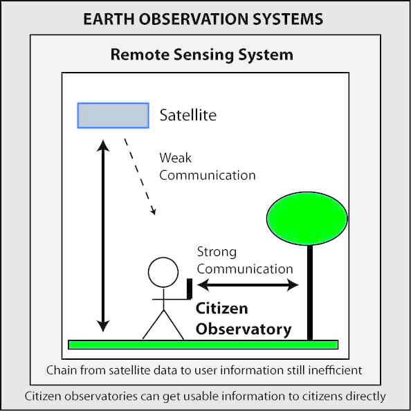
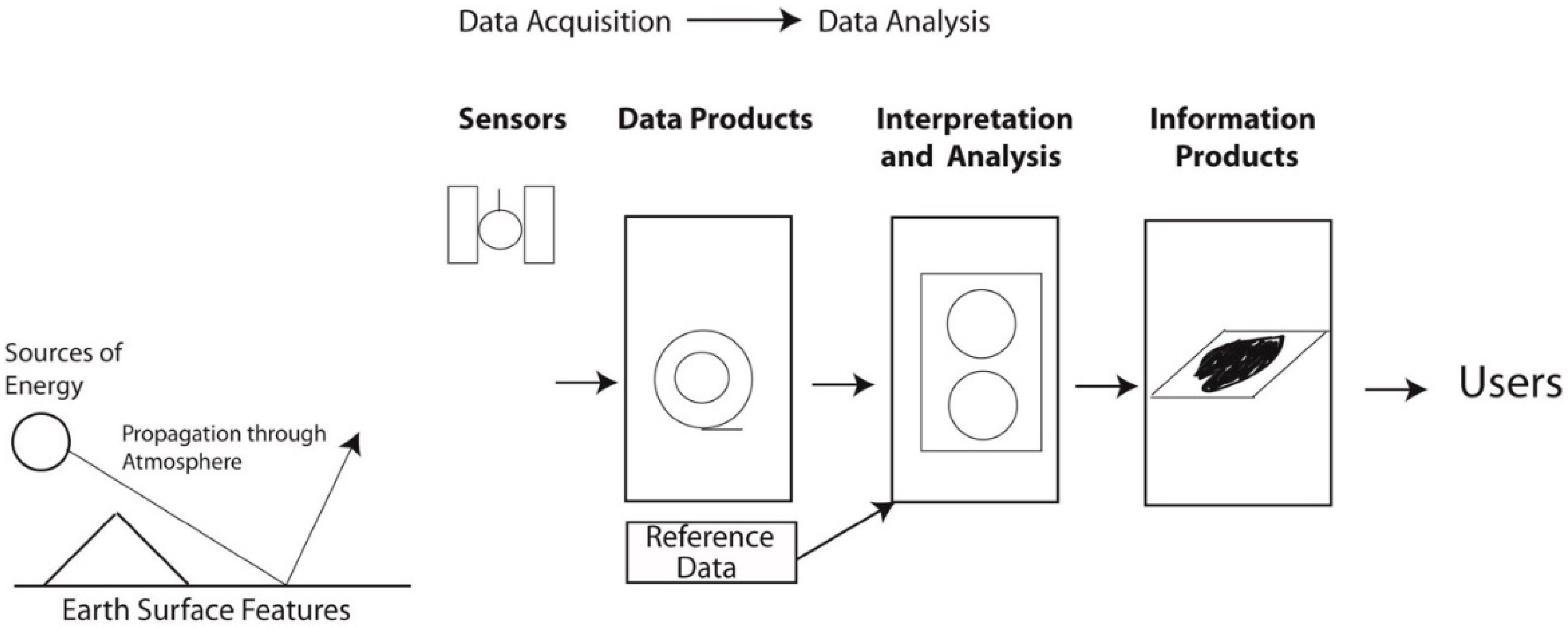
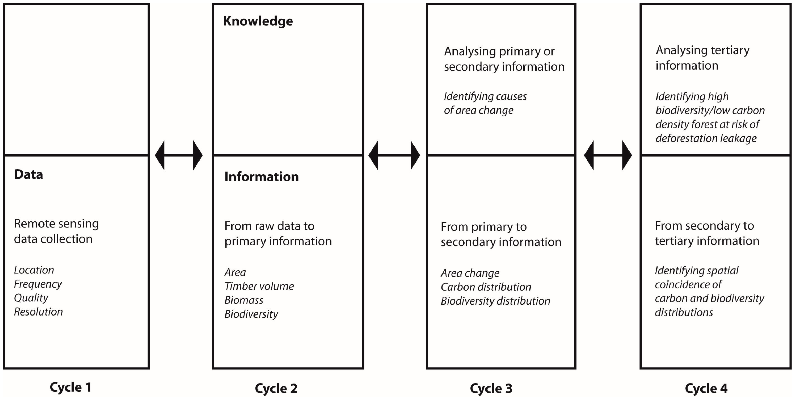
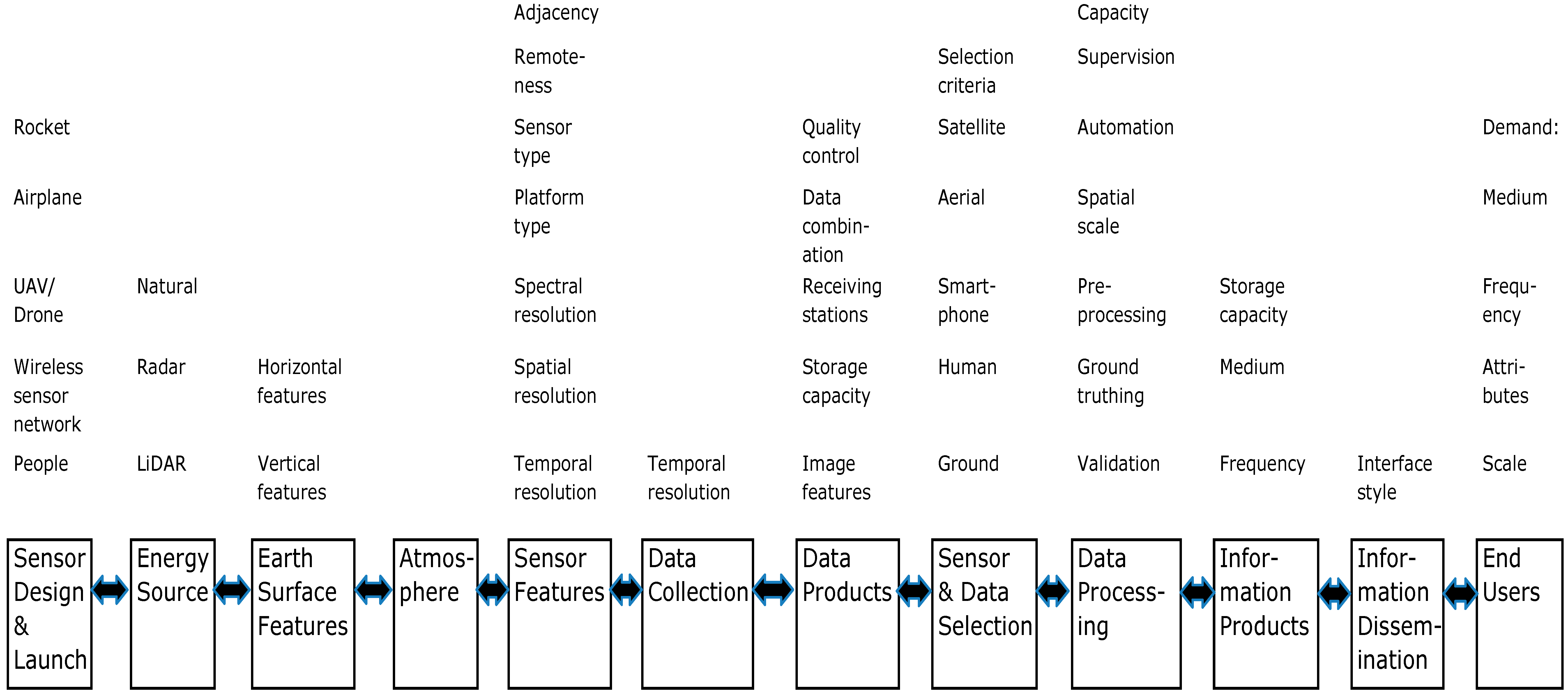
| Characteristics | Sources |
|---|---|
| Characteristics of Projects that Motivate Volunteers | |
| [25] |
| [23] |
| [23] |
| [23,26] |
| [23] |
| [23] |
| [21] |
| [21] |
| [21] |
| Characteristics of Websites that Motivate, Recruit and Retain Volunteers | |
| [23] |
| [27] |
| [23] |
| [23] |
| [28] |
| [25] |
| [29] |
| Characteristics of Websites that Control Data Quality | |
| [23] |
| [23] |
| [23] |
| [23] |
| [23] |
| [23] |
| [23] |
| Priority | Sources |
|---|---|
| [49] |
| [33] |
| [43,50] |
| [43,49] |
Table 3.
A list of distinctive features of effective citizen observatories that refines features proposed earlier [33].
| Feature |
|---|
|
|
|
|
| Lillesand and Kiefer [54] | Strahler et al. [55] | Phinn [56] | Schott [57] |
|---|---|---|---|
| - | - | - |
| Yes | - | - |
| Yes | - | - |
| Yes | Yes | - |
| - | Yes | Yes |
| - | Yes | Yes |
| - | Yes | Yes |
| - | - | - |
Table 5.
Sources of repetitive functioning in a remote sensing system for monitoring tropical forest area change and a citizen tree observatory, showing possible blockages for communication (C), economic (E), institutional (I), natural (N) and technological (T) reasons.
| Component | Passive Satellite Remote Sensing System | Citizen Observatory | ||
|---|---|---|---|---|
| Repetition | Possible Blockages | Repetition | Possible Blockages | |
| Discretionary | T | Discretionary | I |
| Automatic | - | Automatic | - |
| - | - | - | - |
| - | N | - | - |
| Automatic | T | Discretionary | I, T |
| Automatic | - | Discretionary | I, T |
| Automatic | N | Discretionary | I, T |
| Discretionary | E, I | Automatic | - |
| Semi-Automatic | E, I, T | Discretionary | I, T |
| Discretionary | I, C | Discretionary | I, C |
| Discretionary | I, C | Discretionary | I, C |
| - | - | - | - |
© 2017 by the author. Licensee MDPI, Basel, Switzerland. This article is an open access article distributed under the terms and conditions of the Creative Commons Attribution (CC BY) license ( http://creativecommons.org/licenses/by/4.0/).
Share and Cite
MDPI and ACS Style
Grainger, A. Citizen Observatories and the New Earth Observation Science. Remote Sens. 2017, 9, 153. https://doi.org/10.3390/rs9020153
AMA Style
Grainger A. Citizen Observatories and the New Earth Observation Science. Remote Sensing. 2017; 9(2):153. https://doi.org/10.3390/rs9020153
Chicago/Turabian StyleGrainger, Alan. 2017. "Citizen Observatories and the New Earth Observation Science" Remote Sensing 9, no. 2: 153. https://doi.org/10.3390/rs9020153
Note that from the first issue of 2016, this journal uses article numbers instead of page numbers. See further details here.