Article

Temporal and Spatial Changes and Driving Forces of Soil Properties in Subtropical Mountainous Areas from 2017 to 2020: A Case Study of Baokang County, Hubei Province, China

1
Key Laboratory for Geographical Process Analysis & Simulation of Hubei Province, Central China Normal University, Wuhan 430079, China
2
The College of Urban & Environmental Sciences, Central China Normal University, Wuhan 430079, China
3
Technology Innovation Center for Land Spacial Eco-Restoration in Metropolitan Area, Ministry of Natural Resources, Shanghai 200436, China
*
Author to whom correspondence should be addressed.
These authors contributed equally to this work and should be considered co-first authors.
Land 2022, 11(10), 1735; https://doi.org/10.3390/land11101735
Submission received: 11 September 2022 / Revised: 5 October 2022 / Accepted: 6 October 2022 / Published: 7 October 2022

Abstract

:
Understanding the mechanism of regional soil chemical property changes is crucial for guiding precise farming and further alleviating poverty in mountainous areas. Our aims were to monitor the temporal and spatial changes in the soil chemical property in subtropical mountainous areas and explore the effect of human activities, soil and topographic factors on the changes. In this study, a total of 332 soil samples were collected from 2017 to 2020 in Baokang County, subtropical mountainous area in central China. We analyzed the soil pH, soil organic matter (OM), soil available phosphorus (AP), soil available potassium (AK), soil total nitrogen (TN) and used Kriging interpolation to draw the map of spatial distribution of soil chemical properties in Baokang County from 2017 to 2020. The geographical detector was used to explore the driving forces of soil chemical property change over the years of research. The results show that: 1) from 2017 to 2020, soil pH, soil OM, and soil AP in Baokang County was increasing from north to south and the value of three chemical properties showed a slight decreasing trend. Soil AK showed an increasing trend, with higher values in Longping and Xiema towns and relatively lower values in Guoduwan, and soil TN was at a high level with large spatial variation. 2) The human activities, soil and topographic factors all affect soil properties in Baokang. In human activities, the cropping system and crop yield were strong explanatory factors for the changes in soil chemical properties, especially for AK and AP. The q values of all the indicators in the soil factor were relatively high, which displays that all indicators we selected affected the changes in soil properties. Soil OM and soil TN were the factors that affected each other with the greatest driving force, as were soil AP and soil AK. The driving force of DEM was greater among the topographic factors (slope, topographic relief and DEM), and its effect on five soil chemical properties showed that AK>AP>OM>TN>pH. 3) The interactions between each two factors showed a two-factor-enhanced relation, indicating that multiple factors form the soil properties of Baokang County. The findings of this study offer some scientific basis and suggestions for local government to control soil quality and economic development.

1. Introduction

Soil, the basis of life and ecosystem biodiversity, provides the fundamental services for the ecological environment, agriculture, human health, and social development [1,2]. However, during global urbanization, intensive agricultural activities and over-utilization of soil resources led to a series of soil degradation all over the world. Soil erosion, soil pollution, soil acidification is threatening global food security, which is against the Sustainable Development Goals of the United Nation [3,4]. Soil health preservation has become one of the hottest topics of governments and scholars worldwide [5,6,7]. The soil degradation area caused by erosion, swamping, salinization, soil acidification, and fertility decline is about 460 million hectares, accounting for about 40% of the country’s total land area and 1/4 of the world’s degraded soil area. China is one of the countries which suffers from soil degradation [8]. To keep national food security, the government of R.P. China has launched policies to ensure sustainable agricultural development. For example, building high-standard farmland could improve soil quality for increasing framing output through field consolidation engineering, soil management and ecological protection. In order to adjust land management activities accordingly to the needs of sustainable agricultural development, monitoring the dynamics of the soil properties and the food production corresponding to those properties is one of the efficient methods [9,10,11].
Soil chemical properties are important indicators of soil quality and are closely related to changes in soil productivity [12]. It is important to understand the changes in soil properties, which means that measures can be taken to reduce the impact of these changes on agricultural production [13]. Numerous studies have described the spatial distribution of soil properties and provide a theoretical basis for further improving regional soil management policies according to their findings of studies, especially soil pH, soil organic matter (OM), soil available potassium (AK), soil available phosphorus (AP), and soil total nitrogen (TN) [14]. For example, Bertin Takoutsing et al. (2017) [15] provided sensible advice for soil management in the Cameroon region by analyzing the spatial correlation of soil properties such as soil organic matter, soil nitrogen, soil pH, and soil phosphorus; Guimaraes at al. (2008) [16] measured Organic C, exchangeable calcium, magnesium, potassium, extractable phosphate, and soil pH to assess annual changes in soil chemical properties. Although other studies have explored the drivers of change in soil properties using correlation analysis, principal component analysis, and regression analysis based on spatial and temporal patterns of soils, the spatial heterogeneity of regional soil properties has been ignored [17,18]. The tool of Geodetector can fill this gap [19,20]. Therefore, it is important to analyze the main factors affecting regional soil property changes from the perspective of spatial heterogeneity.
Some scholars have also explored the condition of Chinese soils. For example, Chen et al. (2020) [21] analyzed the temporal and spatial changes in the soil properties in a large grain-production area of China’s subtropical plain. Wu et al. (2019) [22] explored the temporal and spatial characteristics of 10 soil chemical properties in the Yellow River delta in 2014. However, these studies have mainly focused on the plains of China, and little information is available on the mechanisms of soil property changes in subtropical mountainous areas. In contrast, as an important agricultural production area in China, subtropical mountainous areas have serious soil degradation due to geographical characteristics, which seriously threatens the regional food production and sustainable economic development. Understanding the spatial patterns of soil chemical properties in subtropical mountainous areas is important for monitoring the evolution of regional soil functions and optimizing fertilization management [23]. In this study, we selected the subtropical mountain areas as the study area which was beneficial in filling the blank of soil research.
In view of this, the main questions explored in this study are: (1) what changes have taken place in the soil properties of subtropical mountainous areas during urbanization? (2) What factors affect the change of soil chemical properties of cultivated land in subtropical mountainous areas? (3) Is the effect of two-factor interaction on the change of soil chemical properties higher than that of a single factor? (Figure 1). The results of this study could be references for high-quality soil management in subtropical mountainous areas, which is conducive to improving regional grain production, ensuring food security, and achieving regional sustainable development.

2. Materials and Methods

2.1. Study Area

Baokang County (110°45′ E–111°31′ E, 31°21′ N–32°06′ N) is located in the northwest of Hubei Province and southwest of Xiangyang City (Figure 2). It covers an area of 3225 km2 and is the only mountainous county in Xiangyang City. The central vein of Jing mountain stretches from east to west, the Nan River water system to the north of Jingshan flows into the Han River, and the Jushui water system to the south of Jingshan flows into the Yangtze River. The average elevation in Baokang is 910 m, and 88.7% of the area is higher than 500 m above sea level. The highest point is the Guanshan, Xiema Town, with an elevation of 2000 m. There is the subtropical continental monsoon climate. The complex terrain in Baokang creates a diverse environment. In low mountains and valleys, there are four distinct seasons: long winters and summers and short springs and autumns. In semi-alpine areas, winters are long and summers are short. In the areas of high mountains, winters last without summers, and springs and autumns are connected. The annual average temperature in the region is 15.6 °C, the average annual rainfall is 934.6 mm, and the average yearly frost-free period is 240 days [24]. The soil parent material of Baokang County is mainly mudstone type and carbonate type, and there are various soil types in Baokang County, mainly mountain yellow-brown earth, brown earth, brown calcareous soil, submerged paddy soil, hydromorphic paddy soil, gray fluvo-aquic soil, gray-purple soil, yellow-brown earth, and so on. Among them, the mountain yellow-brown earth is the most widely distributed, accounting for 33.11% of the total study area, followed by yellow-brown loam and brown-limestone soil. The soil in Baokang County is slightly acidic level to acidic level. Still, the regional hydrothermal conditions are very good, and the natural soil fertility is relatively high, which is suitable for growing a variety of forest trees and cultivating some food crops and special cash crops [25].
Agriculture plays a vital role in Baokang County’s economic income, but most farmers still carry out intensive and conventional cultivation on the soil. The total cultivated land area of Baokang County from 2017 to 2020 was 424.33 km2, 424.65 km2, 293.93 km2, and 285.10 km2, respectively, showing a downward trend overall. Dry land in Baokang County is the primary type of cultivated land, accounting for more than 85% of the total cultivated land area, and most areas are double-cropping a year. The drylands in Baokang County are the main type of cultivated land, accounting for more than 85% of the total cultivated land area. The cultivated land in the area is mainly used for planting crops such as corn, rice, wheat, and potatoes. Most areas are double-cropping systems, such as rice–wheat (RW), rice–rape (RR), maize–wheat (MW), and maize–rape (MR), and only one type of food crop or cash crop are grown in some areas (Figure 3) [26].

2.2. Sampling Design and Laboratory Analyses

To avoid the growing stage of crops and minimize systematic errors and environmental noise, we collected soil samples in Baokang every November from 2017 to 2020. Suitable sampling locations were selected based on spatial heterogeneity, soil type, and crop species. The Garmin GPS Etrex10 receiver was used to determine the final sampling location. At each site, five topsoil samples (0–20 cm) were collected using a soil drill according to the “S” method and mixed to obtain composite soil samples. Each composite soil sample was placed in an aluminum box and sealed for later laboratory analysis. We also interviewed landowners at each sample site to collect information on crop systems, fertilization status, and tillage practices when sampling.
Soil pH, soil organic matter (OM), available potassium (AK), available phosphorus (AP), and total nitrogen (TN) were tested after air-drying, grinding and sieving of the soil samples. Soil pH was measured by a pH meter (Sartorius Basic pH meter PB-10, Gottingen, Germany) with a soil/water ratio of 1:2.5. OM was measured using the method of dichromate-wet combustion. AP was extracted with 0.5 mol L−1 sodium bicarbonate (NHCO3) and colorimetric analysis [27]. AK was extracted with 1 mol/L NH4Ac and tested by an atomic absorption spectrometer [28]. TN was measured by micro-Kjeldahl method [29].

2.3. Methods

2.3.1. Descriptive Statistic and Tests of Normal Distribution

To ensure the accuracy of the soil data, we used the 3σ rule for outlier detection of the soil sampling data [30].
P { | x i , j E ( x j ) | > 3 σ } = 0.3 % ,
where, x i , j denotes the value of soil property j of sample i; E ( x j ) is the average value of soil property j of all samples; σ represents the standard deviation of soil property j of all samples. If the condition of Equation (1) is not satisfied, it is identified as an outlier and removed when performing data analysis. Ultimately, we identified 96, 70, 70, and 84 samples for 2017–2020, respectively. We used SPSS 26.0 to calculate the sample data’s mean, maximum, minimum, standard deviation, and coefficient of variation for descriptive analysis. Then the kurtosis, skewness, and significance tests (Kolmogorov–Smirnov test, p < 0.05) of the sample data were used to test the normal distribution of the soil data. The normal distribution of the data is a prerequisite for spatial interpolation. If the data did not pass the normal distribution test, we needed to perform logarithmic variation, square root transformation, or Box-Cox transformation on the data; if the data passed the normal distribution test, we performed the spatial interpolation.

2.3.2. Spatial Interpolation

The spatial interpolation technique based on geographic information science (GIS) is a common method to explore the spatial distribution of soil properties, which is based on the principle of using known samples to predict data from unknown samples. The kriging interpolation method, one of the main spatial interpolation methods, is an approach for optimal unbiased valuation of regional variables at unsampled points based on the structural nature of the sample data and semivariance functions. Because of its better intrinsic correlation properties and accuracy, it is widely used in many fields such as soil properties, air pollution, etc. [31]. Among the various types of kriging methods, ordinary kriging has been applied by many scholars to investigate the spatial distribution of soil properties due to its high accuracy in estimating the value of unsampled points, especially in agricultural land [32,33,34]. Therefore, we used the Ordinary Kriging (OK) method to explore the spatial distribution characteristics of pH, OM, AK, AP, and TN in this study.

2.3.3. Geographical Detector

The geographical detector is a statistical method to detect the spatial heterogeneity of geographic phenomena or geographic things and reveal the driving factors behind the phenomena, mainly including four detectors: factor detector, interaction detector, risk detector, and ecological detector. The core assumption of this method is that if geographic element X is influenced by geographic element Y, there is a certain similarity between X and Y in spatial distribution. Since Jinfeng Wang et al. (2010) [35] proposed this method in 2004, the geographical detector has been extremely popular among scholars for its unique advantages. It has been gradually applied to various fields such as environment, landscape, society, and land use [36,37].
The geographical detector not only can detect the magnitude of the driving force of a single factor, but also measure the driving forces of multi-factor interactions. Additionally, it is immune to the covariance of multiple independent variables. However, when performing the geographical detector, it is necessary to ensure that the explanatory variable (X) is a categorical variable or should be stratified if it is a numerical variable. The magnitude of driving forces is measured by the q value which has a clear physical meaning and expresses that the dependent variable explains 100% of the independent variable—the larger the q value, the stronger the explanation and the greater the degree of influence. The specific formula is as follows:
q = 1 i = 1 l N i σ i 2 N σ 2 = 1 SSW SST
SSW = i = 1 l N i σ i 2
SST = N σ 2 ,
where i = 1, 2… l denotes the strata or classification of the factor; N i and σ i 2 denote the number of cells and variance at strata or class i; N and σ 2 denote the overall number of cells and variance within the study area; SSW and SST represent the within the sum of squares and the total sum of squares, respectively. The q value is taken as [0, 1], and higher q values indicate the stronger explanatory power of independent variables on dependent variables.
The factors used in the geographical detector are not completely independent, so the interaction detector further clarifies the relationship between the factors by assessing the explanatory power when acting together on the dependent variable. The relationship between the two factors (X1 and X2) can be classified into five types, as shown in Table 1.

2.4. Data Processing

We used descriptive analysis, normal distribution detection and spatial interpolation to explore the spatial and temporal variation of soil properties in Baokang County from 2017 to 2020. The accuracy results of spatial interpolation are shown in Table 2, in which the root mean square error (RMSE) of all soil properties for each year is greater than 1. The value of RMSE is similar to the mean error (MAE), which indicates that the interpolated values show a positive correlation with the measured values. In addition, the values of the standard error of mean (SEM) for all soil properties in 2017–2020 were close to 0, and the value of the standard root mean square error (RMSS) was close to 1, indicating the results of spatial interpolation were good. The relevant criteria for soil property classification were launched in the Second State Soil Survey of China (SSSSC), which scholars widely used in soil research [38,39]. We used it to classify and analyze soil properties in this study (Table 3).
Soil is an important natural resource on which human beings depend, influenced by both the natural environment and human activities. Referring to the relevant studies [40,41], we thoroughly considered the compound natural–human influence and selected 12 factors, including natural factors, soil property factors, and human activities (Table 4). The four factors of cropping system (CS), crop yield (CY), population (Pop), and Gross Domestic Product (GDP) represent the impact of human activities on the soil when people are engaged in food production or other activities. The five soil property factors of pH, OM, AK, AP, and TN explore the degree of interaction between each property. The three topographic factors (Slope, Topographic Relief (TR), and DEM) represent the natural environment’s influence on soil properties. CY, Pop, and GDP data were obtained from the Statistical Yearbook of Baokang, topographic factor data were obtained from the Geospatial Data Cloud (http://www.gscloud.cn/ accessed on 16 February 2022), and the rest of the data were collected from soil samples and the field. We explored the influencing degree of the 12 factors on the change of soil properties based on the factor detector and conducted an interaction analysis of two factors. In conducting the geographical detector, the independent variables are required to be type quantities, while some factors selected in this study were numerical quantities. The study was required to be discretized. At present, K-Means, natural breakpoints, and the quantile method are widely used in the discretization process. According to the principle that the larger the q value is the better the classification result, the quantile method of six types is selected to discretize the independent variables in this study.
In summary, we analyzed the spatial and temporal characteristics of soil properties in Baokang County based on soil sampling data. We investigated the single-factor and two-factor interaction effects of topography, human activities, and soil properties to provide some scientific basis for soil quality improvement and management and the upcoming Third State Soil Survey of China.

3. Results

3.1. Temporal and Spatial Changes of Soil Chemical Properties in Baokang

3.1.1. Descriptive Statistic

The results of descriptive statistics of soil data from 2017 to 2020 for Baokang County are shown in Table 5. The mean values of pH, OM, and AP in Baokang County from 2017 to 2020 showed a decreasing trend, the mean value of AK showed an increasing trend, while the mean value of TN fluctuated up and down at 1.68 g/kg. In terms of maximum and minimum values, except that the maximum and minimum values of pH and TN had no significant changes, the maximum values of OM, AK, and AP decreased significantly and the minimum values of OM and AK showed an increasing trend from 2017 to 2020. The trends of SD and CV were similar for all soil properties. The SD and CV of pH, OM, and AK showed decreasing trends, while AP and TN showed fluctuating smoothness. In addition, except for pH, the CV values of all the indicators ranged from 10% to 100%. According to the classification of variation by Hillel (1980) and Bouma (1985), OM, TN, AP, and AK showed moderate variation, while pH (CV < 10%) showed weak variation [42]. In the K–S test, the data were normally distributed only when the p-value was more significant than 0.05. We transformed all the raw soil data with the natural logarithm transformation because the p-values of all the soil chemical properties were less than 0.01 in the K–S test, and the absolute values of kurtosis and skewness of all the data tended to 0, which was in accordance with the law of normal distribution.

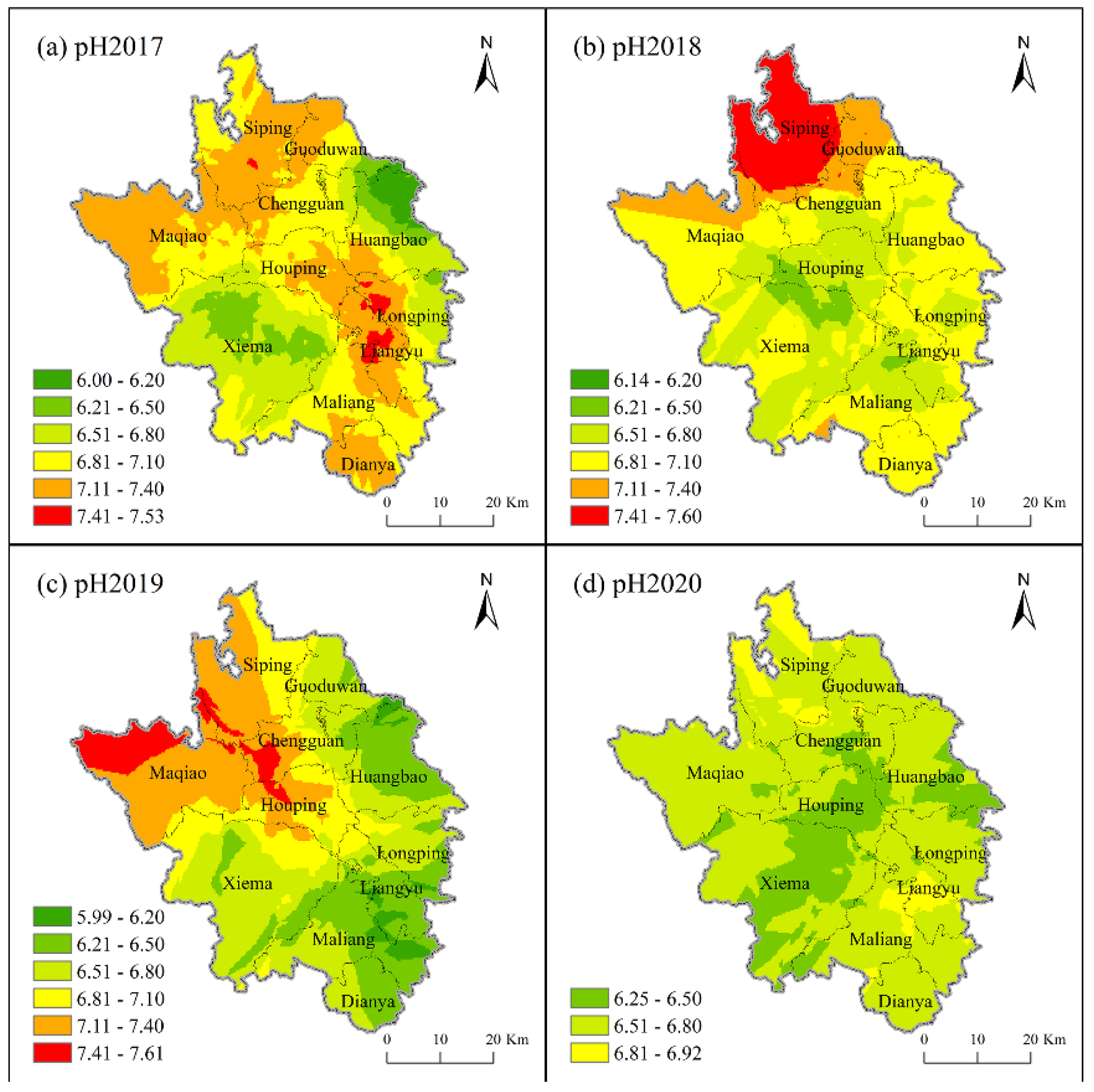
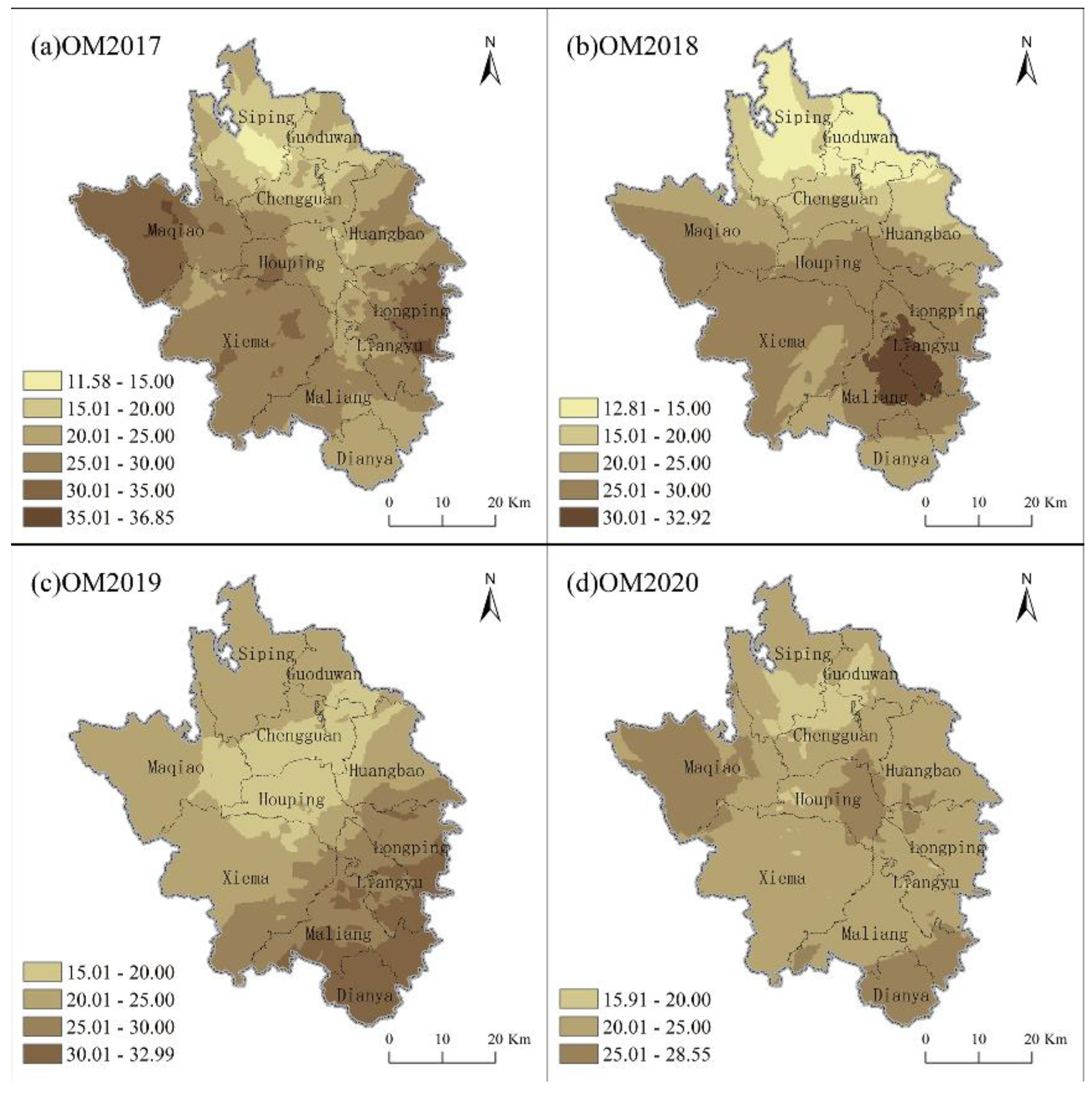
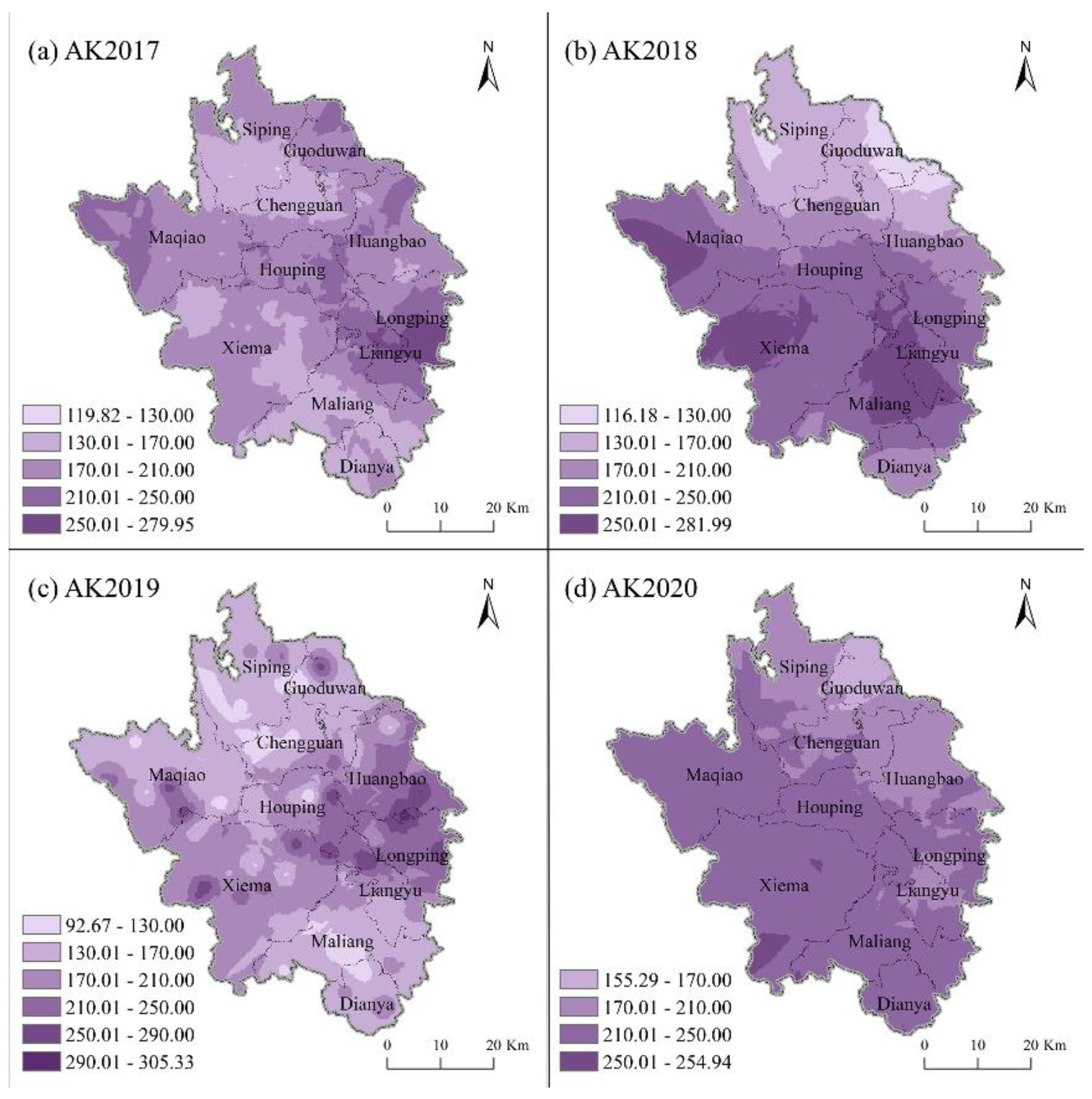
3.1.2. Spatial Distribution of Soil Properties

In this study, based on the classification of soil properties in SSSC (Table 3), we used ordinary kriging to spatially interpolate the soil properties and plotted the spatial distribution map (Figure 4, Figure 5, Figure 6, Figure 7 and Figure 8). There was a trend of decreasing spatial heterogeneity of all soil properties from 2017 to 2020, and significant differences were found in the spatial distribution among the years.
More than 70% of the samples were at neutrality level of soil pH each year, but 7.11%, 14.29%, 28.57%, and 19.05% of the samples had pH < 6.0 in 2017, 2018, 2019, and 2020, respectively, which indicated that the soil showed an acidification trend from 2017 to 2020. As shown in Figure 4, the soil pH in Baokang County was generally neutral. In 2017, soil pH values were higher in the northwest and southeast of Baokang County and lower in the southwest and northeast (Figure 4a). From 2018 to 2019, the high-value areas of pH were located in the three towns of Siping, Maoqiao, and Guoduwan in the north of Baokang County, and the strongest alkaline soil areas in 2018 and 2019 were Siping and Maoqiao, respectively (Figure 4b,c). The spatial distribution trend of soil pH in Baokang County in 2020 was similar to that in 2017. Still, the pH values generally decreased, showing that the trend of soil acidity was noticeable (Figure 4d).
The OM values of soil samples from 2017 to 2020 in Baokang County were all at and above the low level. The number of samples with soil OM at high and very high levels was higher than 30% each year from 2017 to 2020. The number of soil samples with soil OM at medium was the highest, both higher than 50% each year, indicating that the overall soil OM level in Baokang County was at the medium to the high level, and the soil fertility was good (Table 3). The spatial distribution pattern of soil OM from 2017 to 2020 was not entirely consistent (Figure 5), indicating that soil OM is more likely to be influenced by the natural environment and human activities such as fertilization and agricultural management. The highest value areas of soil OM in 2017 were mainly in Maqiao in the west and Longping in the east of Baokang County (Figure 5a). Liangyu, located in southern Baokang County, was the highest value area of soil OM in 2018 (Figure 5b), and in 2019 the high-value areas of OM were still located in Liangyu, Dianya, and Maliang towns in southern Baokang County (Figure 5c). In 2020, Dianya town and Maqiao town remained the areas with the highest soil OM values in Baokang County (Figure 5d), while the low-value areas of soil OM in Baokang County in 2017–2020 were mainly located in Siping, Guoduwan and Chenggaun towns in the north of Baokang County. It was closely related to the local agricultural management and the second and third industries as the leading industries in these regions.
The samples with soil AP at the very high level only appeared in 2017 and also accounted for only 14.72% of all samples in 2017. Soil AP at the high level from 2017 to 2020 was detected with 26.40%, 47.14%, 64.29%, and 51.19% of soil samples, respectively. In addition, from 2017 to 2020, the samples with soil AP at and below the lower medium level were all below 30%, and the values showed a fluctuating downward trend, which indicated that the overall soil AP in Baokang County showed a fluctuating upward trend in four years (Table 3). The differences in the spatial distribution of soil AP in Baokang County from 2017 to 2020 showed a gradual decrease, and the AP values in the southern part of Baokang County were all higher than those in the northern region. According to Figure 6, the areas with high soil AP values in the south part of Baokang County were also higher in elevation, and the areas with low AP values in the northern part of Baokang County were also relatively lower in height, showing the soil AP values are closely related to the elevation. Liangyu, Longping, and Maliang towns all had high soil AP values in the four years, while Siping, Guoduwan, and Chengguan towns all had low soil AP values, requiring moderate supplementation of phosphorus fertilizer to ensure the necessary nutrients for crop growth.
In Baokang County, soil AK in 2017–2020 was greater than 50 mg/kg, indicating that the overall soil AK in the region is high and shows an increasing trend. The highest percentage of samples within each year was at the very high level, 40.10%, 58.57%, 37.14%, and 61.90% in 2017–2020, respectively, which meant that the area of land with soil AK greater than 200 mg/kg was showing an increasing trend during 2017–2020. As shown in Figure 7, the spatial distribution of soil AK varied considerably during the four years. In 2017, high AK values of soil were mainly distributed in Longping and Liangyu in southeastern Baokang County and Maqiao in northwestern Baokang County, and the region of low AK values was mainly located in southern and northern Baokang County, such as Dianya, Maliang, Sipingand, and other towns. The spatial distribution of soil AK in 2018 showed high south and low north profile. In 2019, soil AK values were high in the east and west parts of Baokang County, while the area near the north–south ax showed low soil AK values. However, in 2020, the spatial distribution of soil AK values showed a decreasing trend from southwest to northeast. In general, from 2017 to 2020, soil AK values in the towns of Siping, Chengguan, and Guoduwan were at relatively low levels and required additional potassium fertilizer supplementation, while soil AK in the towns of Maqiao and Longping were both at high levels and should have been protected from potassium overload when conducting farm management.
The samples of soil TN in Baokang County at the low and very low levels were less than 10%. In contrast, the proportion of those at the high and very high levels was higher, and the total proportion of the two levels from 2017 to 2020 was 60.91%, 65.71%, 71.43%, and 59.52%, respectively (Table 3). As shown in Figure 8, the four towns of Siping, Guoduwan, Huangbao, and Chengguan, located in the northeast of Baokang, all had relatively low soil TN in four years. However, the spatial variation of soil TN from 2017 to 2020 varies widely. In 2017, soil TN showed a spatial distribution pattern of high in the east–west and low in the middle. Soil TN in 2018 and 2019 showed a similar spatial distribution pattern with a decreasing trend from south to north. In 2020, it showed a significant decrease in soil TN values and a distribution pattern of low in the north–south and high in the middle.

3.2. Driving Forces of Soil Chemical Property Change

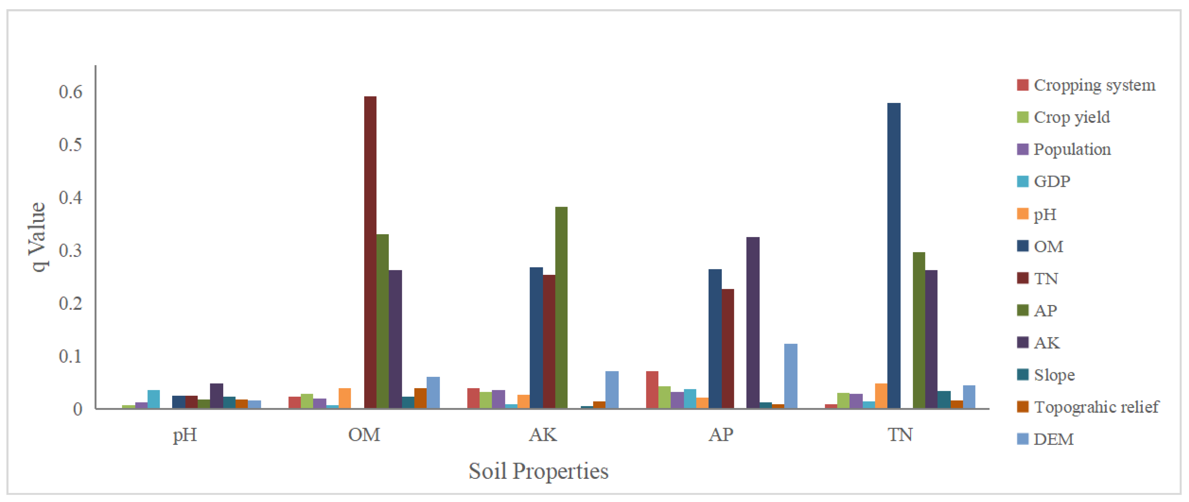
3.2.1. Results of Factor Detector

In this study, the corresponding influencing factors selected according to Table 4 were used in the factor detector for the soil properties (pH, OM, AK, AP, TN). The results were shown in Figure 9, and it was found that all 12 factors had some influence on soil properties, and soil factors were the most influential, indicating that soil properties had more impact on each other. DEM had the next highest degree of influence, and CS was the most influential of the human activities.
The main influencing factors were different for different soil properties. In terms of soil pH, the q values of all factors were lower than 0.1, but the q values of AK and GDP were relatively high, indicating that the changes in pH in Baokang County were closely related to human economic activities and agricultural farming activities. The interactions between soil OM, soil AK, soil AP, and soil TN were high. The driving forces of soil OM on soil TN and soil TN on soil OM were both high, with q values of 0.58 and 0.59, respectively, and the relationships between soil AK and soil AP were similar to those between soil OM and soil TN. In addition, the factors of human activities more strongly influenced the changes in soil AK and soil AP since human agricultural behavior would directly or indirectly affect the changes in soil properties. Especially the changes in the cropping system might lead to changes in the timing and amount of fertilizer application, thus further affecting the changes in soil AK and soil AP. Natural topographic factors also influenced soil properties, especially DEM. Elevation changes indirectly affect changes in the local natural environment, such as precipitation, temperature, sunshine hours, and other aspects of hydrothermal conditions, leading to transformations in soil properties.

3.2.2. Results of Interaction Detector

We found that the driving force of the two-factor interaction was significantly higher than that of the single-factor based on the results of the geographical detector, and the two-factor interaction all appeared to be non-linearly enhanced. It indicated that the influence of each factor on soil properties had multiple and complex characteristics, and the compound effect was significant. However, there are substantial differences in the two-factor interaction effects for different soil properties.
For soil pH (Figure 10a), the interaction of the factors had an enhanced effect on the changes in soil pH, but the enhancement was not high. Significantly, the driving force of the interaction between CS and other factors was low, with q values below 0.1. In addition, the interaction between soil OM and DEM had the strongest driving force on soil pH, with a q value of only 0.23. From Figure 10b,c, it could be seen that the interaction between soil TN and other factors drove the changes in soil OM significantly, with q values above 0.6 and up to 0.71 (the interaction between soil TN and soil AP). Likewise, the interaction between soil OM and other factors also had a greater effect on the change of soil TN, but the effect was slightly lower than the effect of the interaction between soil TN and other factors on the change of soil OM. The two-factor interaction between soil AP and soil AK was similar to the relationship between soil OM and soil TN (Figure 10d,e), that is, the interaction of soil AP with other factors was significantly correlated with changes in soil AK, as was the effect of soil AK interacting with other factors on soil AP, but the enhancement effect was slightly lower than that of soil TN and soil OM interacting with other factors. In addition, the interactions between human activities and the interactions between topographic factors were lesser driving forces for changes in soil chemical properties. Still, they had an increased influence compared to the single factor.

4. Discussion

4.1. Possible Reasons for Soil Chemical Property Change

Soil is an extremely complex eco-environmental system, and changes in its properties are influenced by many factors [41,43]. Considering that the study area in this research was relatively small and changes in topography were the main factors affecting changes in the natural environment (e.g., precipitation, temperature, etc.), the influencing factors were divided into three major categories: topographic factors, human activities and soil factors representing the influence of nature, humans and the soil properties themselves. Among the three categories of indicators, soil factors drive the most impact on the soil properties, with soil TN and soil OM being the factors with the greatest driving force to influence each other, as did soil AK and soil AP (Figure 9). This phenomenon was further confirmed by the results of the interaction detector, where soil TN and soil OM interacted significantly more with each other than with other factors, as did soil AK and soil AP (Figure 10). However, there was some variation in the influence factors for different soil properties.
Soil pH affects soil microbial activity and is closely related to the formation, transformation, and effectiveness of soil nutrients and the growth and development of some plants. pH too high or too low, i.e., salinization or acidification of soil, is detrimental to the growth of crops [44,45]. In China, soil acidification has become a common problem in agricultural development regions. Since the 1980s, the Chinese agriculture has been intensified greatly through modern practices, input of large amounts of chemical fertilizers, irrigation and other resources [46], which has greatly contributed to the acidification of Chinese soils. In Baokang, the value of soil pH showed a slowly decreasing trend from 2017 to 2020. In other words, there was a tendency for soil acidification. This has caused a certain degree of reduction in the effectiveness of many soil nutrients, which is detrimental to soil fertility maintenance and crop growth [47]. According to Figure 9, the interrelationship between soil pH and soil OM, soil AK, soil AP, and soil TN was weak due to the close relationship between pH and the ability of soil itself to resist acid-base changes. For example, the pH of paddy soil was relatively low, while the pH of brown earth and brown calcareous soil was relatively high.
Soil OM is the most active part of the soil, a comprehensive indicator of soil fertility and quality. It plays a crucial role in improving arable land quality, environmental protection, climate change and sustainable agricultural development [48,49]. From 2017 to 2020, soil OM in Baokang County fluctuated, but the decreasing trend was slight. In recent years, the government of Baokang County has implemented the plantation adjustment strategy of “stabilizing grain production, expanding oil production and increasing potato production” [25]. The cultivated land area has shown a decreasing trend (from 42,433 hm2 in 2017 to 28,510 hm2 in 2020), while the yield of grain crops remains stable. It indicates that the intensity of farmland development and utilization in Baokang County has further increased, causing the decline of regional soil organic matter. However, the four-year average of soil OM in Baokang was higher than 20 g/kg, which was at and above the upper-middle level, that is, the overall soil OM was at a high level from 2017 to 2020, and most of the areas with high soil OM in Baokang County were located at higher elevations (Figure 5). According to the results shown in Figure 9, soil OM was influenced by elevation, slope and surface relief, and the q values of these factors were higher than those of human activities such as CS and CY, indicating that natural geography was one of the main driving forces of soil OM changes. It was consistent with Yu Fang et al. (2019) [50] who analyzed soil organic matter content in Hubei Province and concluded that soil organic matter content in western Hubei Province is higher and natural factors have a higher impact on soil organic matter than that of anthropogenic factors.
Soil TN, AP, and AK represent soil fertility, and their values can be used to measure whether they are suitable for plant growth [29]. The mean values of soil TN, soil AP and soil AK in Baokang County from 2017 to 2020 were high, indicating that soil fertility was in good condition. However, the CV values of N, P, and K were all large, which was due to the fact that the changes of soil TN, AP, and AK in the region were not only affected by topography, soil-forming parent material, but also closely related to human activities such as cropping system and fertilizer application. From the results of descriptive statistics, the trends of the mean values of soil AK and AP during the four years were exactly opposite, with soil AK showing a slight falling trend and soil AP showing a slight increase, while the trends of soil TN and soil OM were similar. It was consistent with the findings of Liu et al. (2014) [51].
Based on Table 3, it can be seen that soil TN content was at the medium to the high level when soil TN was greater than 1 g/kg. The average values of soil TN in Baokang County from 2017 to 2020 were greater than 1.5 g/kg, and high levels of soil TN could be observed in almost the entire region (Figure 8), indicating that soil nitrogen was not a production-limiting nutrient in Baokang County. This is consistent with the soil total nitrogen content of 1.5–3 g/kg in northwestern Hubei province in the Chinese soil total nitrogen map by Zhou et al. [52]. In addition, Lu et al. (2000) [53] also proposed that soil nitrogen is more abundant in southern China and excessive use of nitrogen fertilizer will cause a certain degree of soil TN excess, which is similar to the findings of this study. Therefore, proper application of nitrogen fertilizer is an effective measure to improve soil quality in Baokang County and can further reduce non-point source pollution of nitrogen.
As shown in Figure 5, soil AP in Baokang County was in the range of 15–25 mg/kg in most areas during 2017–2020, which is slightly higher than the mean value of soil AP (13.98 mg/kg) reported by Liu et al. (2014) [51] for cropland in southern China. This phenomenon is closely related to the abundant phosphate resources in Baokang County [54]. However, the soil AP concentration in Baokang County from 2017 to 2020 showed a slowly decreasing trend because the Baokang County government has promoted the construction of green mines and attached importance to the green development of the phosphate mining industry with certain effectiveness in recent years. It has also suppressed phosphorus pollution and reduced soil AP to a certain extent [25,55]. The phosphorus in the soil comes mainly from phosphate in the bedrock, which is more easily weathered and released in hotter and more humid environments [56]. In Baokang, the gently sloping mountains and wider river valleys in the south are more favorable for phosphorus release.This finding is consistent with the higher q value of DEM in Figure 9 of this study.
In terms of soil AK, the content in Baokang County is relatively abundant, which is different from the state of potassium deficiency in most plain arable areas in southern China [57]. The difference in topography is the main reason for the difference in AK of soils within Baokang County and southern China. Environmental gradients generated by topography (e.g., sunny and shady slopes, slope positions, river sections, etc.) promote the differentiation of potassium effectiveness at the microscopic scale, which generally shows an increase with elevation [58]. The relatively high elevation, low temperature, low evaporation, and relatively high soil moisture in the whole county of Baokang County result in a lower rate of material decomposition and higher potassium effectiveness, which, together with the stable application of potassium fertilizer, directly or indirectly results in higher effective potassium and a slightly increasing trend in 2017–2020.

4.2. Suggestions for Regional Farming Practices

Changes in soil properties can directly affect the quality of arable land, threatening food security in China. It is a complex process, and the interaction of various soil chemical properties and factors such as topographic factors and human activities will have specific effects on soil properties. To ensure the sustainable use of arable land resources in subtropical mountainous areas, we propose the following land management recommendations according to the results of this study.
Reasonable use of chemical fertilizers. Fertilizer application is an important way for farmers to improve soil nutrients and fertility when engaging in agricultural activities which improves the efficiency of crop residue and root conversion to soil organic matter. However, the excessive application of fertilizers can also result in excess soil nutrients, which is detrimental to crop production. The soil properties in the subtropical mountainous area represented by Baokang County are different from the cultivated land in the plains of southern China, and therefore there is some nuance to the way fertilizers are used in this region. Soil TN in Baokang County has always been at a high level. Therefore, nitrogen fertilizer input should be reasonably controlled in future agricultural activities to prevent excessive nitrogen input from increasing the leaching of reactive nitrogen and gas emissions and achieve green and efficient production [59,60]. In terms of potassium fertilizer use, since the distribution of soil AK is significantly related to the variation of topography, local farmers should fully consider the effectiveness of different altitudes and topographic conditions on potassium. Some studies have indicated that the cadmium content of soils with excessive long-term application of phosphorus fertilizers is tens or even hundreds of times higher than the ordinary soil, which will cause soil cadmium pollution [61]. According to the Statistical Yearbook of Hubei Rural [62], the soil AP in Baokang was at a high level in 2017–2020, and the use of phosphorus fertilizer in Baokang still showed fluctuating growth in 2017–2020. Therefore, the current accumulation of soil phosphorus in Baokang County should be fully considered in future agricultural activities. In addition, promoting organic fertilizers or advocating the use of organic fertilizers in combination with chemical fertilizers is an important initiative to improve regional soil quality and ensure food security. Compared to chemical fertilizers used alone, the use of organic fertilizers can not only increase the content of soil organic matter and a variety of biologically active substances and improve soil’s physical, chemical and biological properties, but also provide a gradual, continuous and comprehensive supply of nutrients for crops [63]. It is conducive to increasing crop yield and improving the quality of agricultural products [64].
Mitigate the soil acidification, improve cropping systems, and implement a rational approach for select crops to be grown. Using chemical fertilizers, especially ammonium nitrogen fertilizers which release protons through nitrification, can accelerate soil acidification to a certain extent and constrain the sustainable development of local agriculture [65]. Therefore, the rational use of fertilizers is also one of the methods to mitigate local soil acidification. However, some areas within the subtropical mountainous regions are mainly planted with special cash crops such as tea, which likes acidic soil, so the local crops should be fully considered when balancing the soil pH. In addition, it is a more economical way to select suitable crops based on soil properties and terrain characteristics than the high cost of using fertilizers to neutralize soil pH to mitigate over-acidic or over-alkaline soils [66]. For example, tea and oil tea can be planted on acidic slopes, while cereals can be planted in relatively flat areas. Nouri et al. (2019) [67] also showed that crop rotations could increase biomass input, contribute to biodiversity and improve soil quality. Therefore, crop rotation in suitable areas is also one of the effective methods to maintain soil fertility and achieve sustainable agricultural development in subtropical mountainous areas.
Focus on soil and water conservation. Taking fully into account the particular characteristics of the geographical location of subtropical mountainous areas with large topographic relief, concentrated precipitation and severe soil erosion, we suggest that local government should focus on soil and water conservation measures, such as improving irrigation facilities, promoting water conservation facilities and building soil and water conservation projects [68,69].

4.3. Strength and Weakness

Changes in soil properties are closely related to soil quality, soil fertility and food production, affecting the sustainable development of regional agricultural activities and ecological protection. In recent years, the study of soil property changes and their driving factors has received much attention from scholars. Different scholars have adopted various methods to explore the spatial distribution of soil properties and their interaction relationships. Still, most of them explore the influence factors based on correlation analysis, principal component analysis and other analytical approaches to determine the main influence indicators, ignoring the role of space [70]. Based on the perspective of spatial heterogeneity, this study fully quantified the driving forces of soil property changes and further explored the influence of two-factor interactions on soil property changes. We found that the interaction between soil TN and other factors has a greater impact on soil OM changes, and the interaction between soil OM and other factors also has a greater influence on soil TN, and soil AP and soil AK have the same relationship. To a certain extent, it can provide some theoretical basis for fertilization structure adjustment, land management improvement, and sustainable agricultural development in subtropical mountainous areas. In addition, most studies on soil property changes and influencing factors have focused on plain areas, and relatively few studies have been conducted in mountainous and hilly areas. In this study, Baokang County, a subtropical mountainous area, was selected as the study area to investigate the spatial and temporal changes of five soil properties, namely soil pH, OM, AK, AP, and TN, and their driving factors from 2017 to 2020, which enriches research in this area.
The change of soil property is a complex process that varies over time and is influenced by multiple factors. Although a lot of work has been done by us using soil measurement data, the possibility of finding more influencing factors of changes and more accurate spatial distribution of soil chemical properties still exists. Certainly, there is still a need to explore the variability of soil chemistry and its drivers in subtropical mountains based on available data. However, several issues should be carefully addressed in subsequent works. Firstly, more samples should be selected to obtain the measured data to reduce the uncertainty of spatial interpolation to get the pattern of soil chemical properties. Secondly, some meteorological monitoring stations should be set up near the soil samples to record the precipitation and temperature data in detail to further accurately investigate the relationship between soil properties and meteorological factors. In addition, this study only monitored soil properties from 2017 to 2020, so we should prolong the study to explore the changes in soil properties and the main driving forces on a longer time scale [71]. It is beneficial for a more accurate understanding of soil conditions in subtropical mountainous areas.

5. Conclusions

In this study, using descriptive statistical methods, spatial interpolation, and the geographical detector, we investigated and analyzed the spatial and temporal variations of soil OM, AP, AK, TN, and pH in cultivated land in subtropical mountainous areas from 2017 to 2020 and explored the driving forces of changes in five soil properties from single-factor and two-factor interactions. The main conclusions are shown below.
(1) Soil pH, OM, and AP in Baokang County showed a slight downward trend, soil AK showed an upward trend, and soil TN remained relatively stable at a high level. The spatial variation of each soil property was at an intermediate level from 2017 to 2020 and showed a decreasing trend.
(2) The spatial pattern of each soil property from 2017 to 2020 had some variation. Regarding soil pH, the soil in Baokang County showed a pattern of south acidity and north alkalinity. Soil OM values were relatively high in southeastern and northwestern Baokang County and soil AP showed a spatial pattern of high in the south and low in the north. Soil AK values in Siping, Chengguan, and Guoduwan were relatively low, while soil AK in the towns of Maqiao and Longping were both at high levels. The four towns of Siping, Guoduwan, Huangbao, and Chengguan, located northeast of Baokang, all had relatively low soil TN in the four years.
(3) Soil factors, topographic factors, and human activities all influence changes in soil chemical properties. Soil factor was the most influential factor, and DEM and CS were the most influential indexes in topographic factors and human activities, respectively. However, the main driving factors affecting the changes in different soil properties differ. All factors had the least effect on soil pH; soil OM and soil TN had a stronger influence on each other, and soil AK and soil AP had a stronger impact on each other.
(4) The effects of various factors in the natural–human environment on changes in soil chemical properties show multiple and complex characteristics. Compared to single-factor, the influence of two-factor interaction was significantly stronger, where soil TN and other factors interacting with each other had a greater effect on soil OM, and soil OM and other factors interacting with each other had a greater impact on soil TN, as does the relationship between soil AP and soil AK, while all two-factor interactions influenced soil pH to a lesser extent.
(5) The local government should adjust the fertilizer structure and planting system, improve water conservancy facilities, and implement soil conservation projects to alleviate soil acidification and erosion, prevent soil pollution, promote high-quality sustainable agricultural development, and provide a more solid guarantee for food security.

Author Contributions

Resources preparation, software and validation, T.X.; conceptualization, data analysis and writing—original draft, S.Y.; methodology, software, and visualization, Q.L.; investigating and writing —review and editing, Y.L.; supervision, project administration and funding acquisition, Y.Z. All authors have read and agreed to the published version of the manuscript.

Funding

This work was supported by The National Natural Science Foundation of China (41271534); China Scholarship Council (201906770044).

Data Availability Statement

Not applicable.

Acknowledgments

We acknowledge all people who contributed to the data collection and processing, as well as the constructive and insightful comments by the editor and anonymous reviewers.

Conflicts of Interest

The authors declare no conflict of interest.

References

  1. Fierer, N.; Wood, S.A.; Bueno de Mesquita, C.P. How Microbes Can, and Cannot, Be Used to Assess Soil Health. Soil Biol. Biochem. 2021, 153, 108111. [Google Scholar] [CrossRef]
  2. Daliakopoulos, I.N.; Tsanis, I.K.; Koutroulis, A.; Kourgialas, N.N.; Varouchakis, A.E.; Karatzas, G.P.; Ritsema, C.J. The Threat of Soil Salinity: A European Scale Review. Sci. Total Environ. 2016, 573, 727–739. [Google Scholar] [CrossRef] [PubMed]
  3. Lwin, C.S.; Seo, B.-H.; Kim, H.-U.; Owens, G.; Kim, K.-R. Application of Soil Amendments to Contaminated Soils for Heavy Metal Immobilization and Improved Soil Quality—A Critical Review. Soil Sci. Plant Nutr. 2018, 64, 156–167. [Google Scholar] [CrossRef]
  4. Song, W.; Zhang, H.; Zhao, R.; Wu, K.; Li, X.; Niu, B.; Li, J. Study on Cultivated Land Quality Evaluation from the Perspective of Farmland Ecosystems. Ecol. Indic. 2022, 139, 108959. [Google Scholar] [CrossRef]
  5. Nawaz, M.F.; Bourrié, G.; Trolard, F. Soil Compaction Impact and Modelling. A Review. Agron. Sustain. Dev. 2013, 33, 291–309. [Google Scholar] [CrossRef] [Green Version]
  6. Dai, Z.; Zhang, X.; Tang, C.; Muhammad, N.; Wu, J.; Brookes, P.C.; Xu, J. Potential Role of Biochars in Decreasing Soil Acidification—A Critical Review. Sci. Total Environ. 2017, 581–582, 601–611. [Google Scholar] [CrossRef] [PubMed]
  7. Palansooriya, K.N.; Ok, Y.S.; Awad, Y.M.; Lee, S.S.; Sung, J.-K.; Koutsospyros, A.; Moon, D.H. Impacts of Biochar Application on Upland Agriculture: A Review. J. Environ. Manag. 2019, 234, 52–64. [Google Scholar] [CrossRef] [PubMed]
  8. Luo, Y.; Teng, Y. Status of Soil Pollution Degradation and Countermeasures in China. Soils 2006, 38, 505–508. [Google Scholar]
  9. Zhang, S.; Zhang, X.; Huffman, T.; Liu, X.; Yang, J. Influence of Topography and Land Management on Soil Nutrients Variability in Northeast China. Nutr. Cycl. Agroecosyst. 2011, 89, 427–438. [Google Scholar] [CrossRef]
  10. Bogunovic, I.; Trevisani, S.; Seput, M.; Juzbasic, D.; Durdevic, B. Short-Range and Regional Spatial Variability of Soil Chemical Properties in an Agro-Ecosystem in Eastern Croatia. CATENA 2017, 154, 50–62. [Google Scholar] [CrossRef]
  11. Behera, S.K.; Mathur, R.K.; Shukla, A.K.; Suresh, K.; Prakash, C. Spatial Variability of Soil Properties and Delineation of Soil Management Zones of Oil Palm Plantations Grown in a Hot and Humid Tropical Region of Southern India. CATENA 2018, 165, 251–259. [Google Scholar] [CrossRef]
  12. Bogunovic, I.; Pereira, P.; Brevik, E.C. Spatial Distribution of Soil Chemical Properties in an Organic Farm in Croatia. Sci. Total Environ. 2017, 584–585, 535–545. [Google Scholar] [CrossRef] [PubMed] [Green Version]
  13. Gozukara, G.; Akça, E.; Dengiz, O.; Kapur, S.; Adak, A. Soil Particle Size Prediction Using Vis-NIR and PXRF Spectra in a Semiarid Agricultural Ecosystem in Central Anatolia of Türkiye. CATENA 2022, 217, 106514. [Google Scholar] [CrossRef]
  14. Ozlu, E.; Gozukara, G.; Acar, M.; Bilen, S.; Babur, E. Field-Scale Evaluation of the Soil Quality Index as Influenced by Dairy Manure and Inorganic Fertilizers. Sustainability 2022, 14, 7593. [Google Scholar] [CrossRef]
  15. Takoutsing, B.; Martín, J.A.R.; Weber, J.C.; Shepherd, K.; Sila, A.; Tondoh, J. Landscape Approach to Assess Key Soil Functional Properties in the Highlands of Cameroon: Repercussions of Spatial Relationships for Land Management Interventions. J. Geochem. Explor. 2017, 178, 35–44. [Google Scholar] [CrossRef]
  16. Guimaraes, M.F.; Fonseca, I.C.B.; Brossard, M.; Portella, C.M.R.; Brito, O.R.; Ritchie, J.C. Monitoring Changes in the Chemical Properties of an Oxisol under Long-Term No-Tillage Management in Subtropical Brazil. Soil Sci. 2008, 173, 408–416. [Google Scholar] [CrossRef] [Green Version]
  17. Guo, P.; Xie, Z.; Li, J.; Kang, C.; Liu, J. Relationships between Fractionations of Pb, Cd, Cu, Zn and Ni and Soil Properties in Urban Soils of Changchun, China. Chin. Geograph. Sci. 2005, 15, 179–185. [Google Scholar] [CrossRef]
  18. Johnson, B.G.; Verburg, P.S.J.; Arnone, J.A. Effects of Climate and Vegetation on Soil Nutrients and Chemistry in the Great Basin Studied along a Latitudinal-Elevational Climate Gradient. Plant Soil 2014, 382, 151–163. [Google Scholar] [CrossRef]
  19. Du, Z.; Gao, B.; Ou, C.; Du, Z.; Yang, J.; Batsaikhan, B.; Dorjgotov, B.; Yun, W.; Zhu, D. A Quantitative Analysis of Factors Influencing Organic Matter Concentration in the Topsoil of Black Soil in Northeast China Based on Spatial Heterogeneous Patterns. ISPRS Int. J. Geo-Inf. 2021, 10, 348. [Google Scholar] [CrossRef]
  20. Su, Y.; Li, T.; Cheng, S.; Wang, X. Spatial Distribution Exploration and Driving Factor Identification for Soil Salinisation Based on Geodetector Models in Coastal Area. Ecol. Eng. 2020, 156, 105961. [Google Scholar] [CrossRef]
  21. Chen, S.; Lin, B.; Li, Y.; Zhou, S. Spatial and Temporal Changes of Soil Properties and Soil Fertility Evaluation in a Large Grain-Production Area of Subtropical Plain, China. Geoderma 2020, 357, 113937. [Google Scholar] [CrossRef]
  22. Wu, C.; Liu, G.; Huang, C.; Liu, Q. Soil Quality Assessment in Yellow River Delta: Establishing a Minimum Data Set and Fuzzy Logic Model. Geoderma 2019, 334, 82–89. [Google Scholar] [CrossRef]
  23. Rosemary, F.; Vitharana, U.W.A.; Indraratne, S.P.; Weerasooriya, R.; Mishra, U. Exploring the Spatial Variability of Soil Properties in an Alfisol Soil Catena. CATENA 2017, 150, 53–61. [Google Scholar] [CrossRef]
  24. CMDC China Meteorological Data Service Center. Available online: http://data.cma.cn/ (accessed on 11 August 2022).
  25. Baokang County Archives. The Statistical Yearbook of Baokang County 2017; National Bureau of Statistics of China: Beijing, China, 2017.
  26. Agricultural Technology Extension Center of Baokang. The Report of Cultivated Land Survey and Evaluation in Baokang; Agricultural Technology Extension Center of Baokang: Baokang, China, 2020. [Google Scholar]
  27. Olsen, S.R. Estimation of Available Phosphorus in Soils by Extraction with Sodium Bicarbonate; U.S. Departement of Agriculture: Washington, DC, USA, 1954.
  28. Institute of Soil Sciences. Chinese Academy of Sciences (ISSCAS) Physical and Chemical Analysis Method of Soils; Shanghai Science and Technology Press: Shanghai, China, 1978; p. 283. [Google Scholar]
  29. Hou, L.; Liu, Z.; Zhao, J.; Ma, P.; Xu, X. Comprehensive Assessment of Fertilization, Spatial Variability of Soil Chemical Properties, and Relationships among Nutrients, Apple Yield and Orchard Age: A Case Study in Luochuan County, China. Ecol. Indic. 2021, 122, 107285. [Google Scholar] [CrossRef]
  30. Hodge, V.; Austin, J. A Survey of Outlier Detection Methodologies. Artif. Intell. Rev. 2004, 22, 85–126. [Google Scholar] [CrossRef] [Green Version]
  31. Babur, E.; Dindaroglu, T.; Danish, S.; Häggblom, M.M.; Ozlu, E.; Gozukara, G.; Uslu, O.S. Spatial Responses of Soil Carbon Stocks, Total Nitrogen, and Microbial Indices to Post-Wildfire in the Mediterranean Red Pine Forest. J. Environ. Manag. 2022, 320, 115939. [Google Scholar] [CrossRef]
  32. Zhu, Q.; Lin, H.S. Comparing Ordinary Kriging and Regression Kriging for Soil Properties in Contrasting Landscapes. Pedosphere 2010, 20, 594–606. [Google Scholar] [CrossRef]
  33. Gozukara, G.; Acar, M.; Ozlu, E.; Dengiz, O.; Hartemink, A.E.; Zhang, Y. A Soil Quality Index Using Vis-NIR and PXRF Spectra of a Soil Profile. CATENA 2022, 211, 105954. [Google Scholar] [CrossRef]
  34. Smirnova, E.V.; Giniyatullin, K.G.; Sahabiev, I.A.; Okunev, R.V. Comparison of Interpolated Soil Nutrients Maps Obtained with Application of Various Approaches of Ordinary Kriging. IOP Conf. Ser. Earth Environ. Sci. 2020, 548, 032027. [Google Scholar] [CrossRef]
  35. Wang, J.; Xu, C. Geodetector: Principle and propective. Acta Geogr. Sin. 2017, 72, 116–134. [Google Scholar]
  36. Qiao, P.; Yang, S.; Lei, M.; Chen, T.; Dong, N. Quantitative Analysis of the Factors Influencing Spatial Distribution of Soil Heavy Metals Based on Geographical Detector. Sci Total Environ. 2019, 664, 392–413. [Google Scholar] [CrossRef] [PubMed]
  37. Chen, Y.; Li, H.; Karimian, H.; Li, M.; Fan, Q.; Xu, Z. Spatio-Temporal Variation of Ozone Pollution Risk and Its Influencing Factors in China Based on Geodetector and Geospatial Models. Chemosphere 2022, 302, 134843. [Google Scholar] [CrossRef] [PubMed]
  38. Yuan, P.; Wang, J.; Li, C.; Xiao, Q.; Liu, Q.; Sun, Z.; Wang, J.; Cao, C. Soil Quality Indicators of Integrated Rice-Crayfish Farming in the Jianghan Plain, China Using a Minimum Data Set. Soil Tillage Res. 2020, 204, 104732. [Google Scholar] [CrossRef]
  39. Zhao, K.; Zhang, L.; Dong, J.; Wu, J.; Ye, Z.; Zhao, W.; Ding, L.; Fu, W. Risk Assessment, Spatial Patterns and Source Apportionment of Soil Heavy Metals in a Typical Chinese Hickory Plantation Region of Southeastern China. Geoderma 2020, 360, 114011. [Google Scholar] [CrossRef]
  40. West, T.O.; Post, W.M. Soil Organic Carbon Sequestration Rates by Tillage and Crop Rotation. Soil Sci. Soc. Am. J. 2002, 66, 1930–1946. [Google Scholar] [CrossRef] [Green Version]
  41. Li, Q.; Gu, F.; Zhou, Y.; Xu, T.; Wang, L.; Zuo, Q.; Xiao, L.; Liu, J.; Tian, Y. Changes in the Impacts of Topographic Factors, Soil Texture, and Cropping Systems on Topsoil Chemical Properties in the Mountainous Areas of the Subtropical Monsoon Region from 2007 to 2017: A Case Study in Hefeng, China. Int. J. Environ. Res. Public Health 2021, 18, 832. [Google Scholar] [CrossRef]
  42. Kasel, S.; Bennett, L.T.; Aponte, C.; Fedrigo, M.; Nitschke, C.R. Environmental Heterogeneity Promotes Floristic Turnover in Temperate Forests of South-Eastern Australia More than Dispersal Limitation and Disturbance. Landsc. Ecol 2017, 32, 1613–1629. [Google Scholar] [CrossRef]
  43. Bai, Z.; Caspari, T.; Gonzalez, M.R.; Batjes, N.H.; Mader, P.; Bunemann, E.K.; de Goede, R.; Brussaard, L.; Xu, M.; Santos Ferreira, C.S.; et al. Effects of Agricultural Management Practices on Soil Quality: A Review of Long-Term Experiments for Europe and China. Agric. Ecosyst. Environ. 2018, 265, 1–7. [Google Scholar] [CrossRef]
  44. Guo, Z.; Wang, J.; Chai, M.; Chen, Z.; Zhan, Z.; Zheng, W.; Wei, X. Spatiaotemporal variation of soil pH in Guangdong Province of China in past 30years. Chin. J. Appl. Ecol. 2011, 22, 425–430. [Google Scholar]
  45. Satiro, L.S.; Cherubin, M.R.; Lisboa, I.P.; Noia Junior, R.d.S.; Cerri, C.C.; Pellegrino Cerri, C.E. Prediction of Sugarcane Yield by Soil Attributes under Straw Removal Management. Agron. J. 2019, 111, 14–23. [Google Scholar] [CrossRef]
  46. Guo, X.; Li, H.; Yu, H.; Li, W.; Ye, Y.; Biswas, A. Drivers of Spatio-Temporal Changes in Paddy Soil PH in Jiangxi Province, China from 1980 to 2010. Sci. Rep. 2018, 8, 2702. [Google Scholar] [CrossRef] [PubMed] [Green Version]
  47. Fageria, N.K.; Baligar, V.C. Chapter 7 Ameliorating Soil Acidity of Tropical Oxisols by Liming For Sustainable Crop Production. In Advances in Agronomy; Academic Press: Cambridge, MA, USA, 2008; Volume 99, pp. 345–399. [Google Scholar]
  48. Jackson, R.B.; Lajtha, K.; Crow, S.E.; Hugelius, G.; Kramer, M.G.; Piñeiro, G. The Ecology of Soil Carbon: Pools, Vulnerabilities, and Biotic and Abiotic Controls. Annu. Rev. Ecol. Evol. Syst. 2017, 48, 419–445. [Google Scholar] [CrossRef] [Green Version]
  49. Yang, X.; Chen, X.; Yang, X. Effect of Organic Matter on Phosphorus Adsorption and Desorption in a Black Soil from Northeast China. Soil Tillage Res. 2019, 187, 85–91. [Google Scholar] [CrossRef]
  50. Yu, F.; Li, H. Study on Spatial Variability of Soil Organic Matter in Hubei Province based on Geostatistics and GIS. Jiangsu Agric. Sci. 2019, 47, 282–286. [Google Scholar]
  51. Liu, Z.; Zhou, W.; Shen, J.; He, P.; Lei, Q.; Liang, G. A Simple Assessment on Spatial Variability of Rice Yield and Selected Soil Chemical Properties of Paddy Fields in South China. Geoderma 2014, 235–236, 39–47. [Google Scholar] [CrossRef]
  52. Zhou, Y.; Xue, J.; Chen, S.; Zhou, Y.; Liang, Z.; Wang, N.; Shi, Z. Fine-Resolution Mapping of Soil Total Nitrogen across China Based on Weighted Model Averaging. Remote Sens. 2020, 12, 85. [Google Scholar] [CrossRef] [Green Version]
  53. Lu, R. Soil Analytical Methods of Agronomic Chemical; Chian Agricultural Science and Technology Press: Beijing, China, 2000. [Google Scholar]
  54. Yan, W.; Fan, J.; Chen, G.; Zhang, J. The spatial concentration of phosphorous mineral resources and industrial layout in Hubei province. Contrib. Geol. Miner. Resour. Res. 2015, 30, 103–110. [Google Scholar]
  55. Lv, Y.; Cao, J.; Wang, Z. The Formation of Environmental Pollution in Phosphate Mines and its Prevention. Conserv. Util. Miner. Resour. 2002, 6, 10–15. [Google Scholar]
  56. Lin, J.-S.; Shi, X.-Z.; Lu, X.-X.; Yu, D.-S.; Wang, H.-J.; Zhao, Y.-C.; Sun, W.-X. Storage and Spatial Variation of Phosphorus in Paddy Soils of China. Pedosphere 2009, 19, 790–798. [Google Scholar] [CrossRef]
  57. Yuan, L.; Zhang, Z.; Cao, X.; Zhu, S.; Zhang, X.; Wu, L. Responses of Rice Production, Milled Rice Quality and Soil Properties to Various Nitrogen Inputs and Rice Straw Incorporation under Continuous Plastic Film Mulching Cultivation. Field Crops Res. 2014, 155, 164–171. [Google Scholar] [CrossRef]
  58. Chen, Y.; Qi, Y.; Wang, Y.; Zhang, L.; Liu, J. Spatial Varibility and Factors Affecting Soil Availavle Potassium in the Central Qinling-Daba Mountain Area. Res. Environ. Sci. 2017, 30, 257–266. [Google Scholar]
  59. Geisseler, D.; Scow, K.M. Long-Term Effects of Mineral Fertilizers on Soil Microorganisms—A Review. Soil Biol. Biochem. 2014, 75, 54–63. [Google Scholar] [CrossRef]
  60. Jin, J.; Wang, L.; Müller, K.; Wu, J.; Wang, H.; Zhao, K.; Berninger, F.; Fu, W. A 10-Year Monitoring of Soil Properties Dynamics and Soil Fertility Evaluation in Chinese Hickory Plantation Regions of Southeastern China. Sci. Rep. 2021, 11, 23531. [Google Scholar] [CrossRef] [PubMed]
  61. Yazici, M.A.; Asif, M.; Tutus, Y.; Ortas, I.; Ozturk, L.; Lambers, H.; Cakmak, I. Reduced Root Mycorrhizal Colonization as Affected by Phosphorus Fertilization Is Responsible for High Cadmium Accumulation in Wheat. Plant Soil 2021, 468, 19–35. [Google Scholar] [CrossRef]
  62. Editorial Board the Statistical Yearbook of Hubei Rural 2017. The Statistical Yearbook of Hubei Rural 2017; China Statistics Press: Beijing, China, 2017. [Google Scholar]
  63. Du, Y.; Cui, B.; Zhang, Q.; Wang, Z.; Sun, J.; Niu, W. Effects of Manure Fertilizer on Crop Yield and Soil Properties in China: A Meta-Analysis. CATENA 2020, 193, 104617. [Google Scholar] [CrossRef]
  64. Qaswar, M.; Jing, H.; Ahmed, W.; Dongchu, L.; Shujun, L.; Lu, Z.; Cai, A.; Lisheng, L.; Yongmei, X.; Jusheng, G.; et al. Yield Sustainability, Soil Organic Carbon Sequestration and Nutrients Balance under Long-Term Combined Application of Manure and Inorganic Fertilizers in Acidic Paddy Soil. Soil Tillage Res. 2020, 198, 104569. [Google Scholar] [CrossRef]
  65. Zeng, M.; de Vries, W.; Bonten, L.T.C.; Zhu, Q.; Hao, T.; Liu, X.; Xu, M.; Shi, X.; Zhang, F.; Shen, J. Model-Based Analysis of the Long-Term Effects of Fertilization Management on Cropland Soil Acidification. Environ. Sci. Technol. 2017, 51, 3843–3851. [Google Scholar] [CrossRef]
  66. Liu, B.; Wu, Q.; Wang, F.; Zhang, B. Is Straw Return-to-Field Always Beneficial? Evidence from an Integrated Cost-Benefit Analysis. Energy 2019, 171, 393–402. [Google Scholar] [CrossRef]
  67. Nouri, A.; Lee, J.; Yin, X.; Saxton, A.M.; Tyler, D.D.; Sykes, V.R.; Arelli, P. Crop Species in No-Tillage Summer Crop Rotations Affect Soil Quality and Yield in an Alfisol. Geoderma 2019, 345, 51–62. [Google Scholar] [CrossRef]
  68. Descroix, L.; González Barrios, J.L.; Viramontes, D.; Poulenard, J.; Anaya, E.; Esteves, M.; Estrada, J. Gully and Sheet Erosion on Subtropical Mountain Slopes: Their Respective Roles and the Scale Effect. CATENA 2008, 72, 325–339. [Google Scholar] [CrossRef]
  69. Chiu, Y.-J.; Chang, K.-T.; Chen, Y.-C.; Chao, J.-H.; Lee, H.-Y. Estimation of Soil Erosion Rates in a Subtropical Mountain Watershed Using 137Cs Radionuclide. Nat. Hazards 2011, 59, 271–284. [Google Scholar] [CrossRef]
  70. Bünemann, E.K.; Bongiorno, G.; Bai, Z.; Creamer, R.E.; De Deyn, G.; de Goede, R.; Fleskens, L.; Geissen, V.; Kuyper, T.W.; Mäder, P.; et al. Soil Quality—A Critical Review. Soil Biol. Biochem. 2018, 120, 105–125. [Google Scholar] [CrossRef]
  71. Qi, Y.; Chang, Q.; Liu, M.; Liu, J.; Chen, T. County-Scale Spatial Variability of Soil Nutrient Distribution and Determination of Reasonable Sampling Density. Chin. J. Soil Sci. 2014, 45, 556–561. [Google Scholar]
Figure 1. Research Framework.
Land 11 01735 g001
Figure 2. Location, elevation, and soil sample location in Baokang County.
Land 11 01735 g002
Figure 3. Cropping system distribution maps of the study area in (a) 2017, (b) 2018, (c) 2019, and (d) 2020.
Land 11 01735 g003
Figure 4. Ordinary kriging distribution maps for (a) 2017 pH, (b) 2018 pH, (c) 2019 pH and (d) 2020 pH.
Land 11 01735 g004
Figure 5. Ordinary kriging distribution maps for (a) 2017 OM, (b) 2018 OM, (c) 2019 OM and (d) 2020 OM.
Land 11 01735 g005
Figure 6. Ordinary kriging distribution maps for (a) 2017 AP, (b) 2018 AP, (c) 2019 AP and (d) 2020 AP.
Land 11 01735 g006
Figure 7. Ordinary kriging distribution maps for (a) 2017 AK, (b) 2018 AK, (c) 2019 AK and (d) 2020 AK.
Land 11 01735 g007
Figure 8. Ordinary kriging distribution maps for (a) 2017 TN, (b) 2018 TN, (c) 2019 TN and (d) 2020 TN.
Land 11 01735 g008
Figure 9. The q Value of the Influence Indicators on Soil Chemical Property. Note: CS—cropping system, CY—cropping yield, Pop—population, OM—organic matter, AP—available phosphorus, AK—available potassium, TN—total nitrogen, Slo—slope, TR—topographic Relief.
Land 11 01735 g009
Figure 10. Interaction of Different influence factors on (a) pH, (b) OM, (c) AK, (d) AP and (e) TN. Note: CS—cropping system, CY—cropping yield, Pop—population, OM—organic matter, AP—available phosphorus, AK—available potassium, TN—total nitrogen, Slo—slope, TR—topographic Relief.
Land 11 01735 g010
Table 1. Interaction relationships for two factors.
DescriptionInteraction Types
q ( X 1 X 2 ) < Min ( q ( X 1 X 2 ) ) Weaken, nonlinear
Min ( q ( X 1 ) , q ( X 2 ) ) < q ( X 1 X 2 ) < Max ( q ( X 1 ) , q ( X 2 ) ) Weaken, uni-
q ( X 1 X 2 ) > Max ( q ( X 1 ) , q ( X 2 ) ) Enhance, bi-
q ( X 1 X 2 ) = q ( X 1 ) + q ( X 2 ) Independent
q ( X 1 X 2 ) > q ( X 1 ) + q ( X 2 ) Enhance, nonlinear
Where q ( X 1 X 2 ) denotes the q value at the interaction of the two factors, Max ( q ( X 1 ) , q ( X 2 ) ) denotes the maximum value at the single factor of X1 or X2, Min ( q ( X 1 ) , q ( X 2 ) ) denotes the minimum value at the single factor of X1 or X2, and q ( X 1 ) + q ( X 2 ) denotes the sum of q values at the single factor of X1 and X2.
Table 2. Accuracy of soil data interpolation in Baokang County.
Soil Chemical
Property
YearRMSESEMRMSSMAE
pH20170.492−0.0020.9900.499
20180.778−0.0290.9650.811
20191.036−0.0020.9671.067
20200.632−0.0091.0270.617
OM201710.260−0.0071.0259.966
20189.9560.0470.97110.371
20199.708−0.0110.9779.941
202010.768−0.0081.06710.065
AP201715.176−0.0160.99015.410
201810.2870.0471.02410.302
20199.292−0.0150.9809.482
20209.878−0.0200.9919.981
AK201767.985−0.0140.97869.693
201880.0580.0061.02678.084
201993.506−0.0271.00393.429
202073.6400.0111.04570.439
TN20170.579−0.0081.0100.572
20180.6960.0041.0050.693
20190.5119.4561.0220.499
20200.644−0.0031.0200.632
Table 3. Classification of soil properties in China.
Level of pHpHLevel of OM, AK, AP and TNOM (g/kg)AK (mg/kg)AP (mg/kg)TN (g/kg)
Extremely acidic<4.5Very low<6<30<3<0.5
Very acidic4.5–5.0Low6–1030–503–50.5–0.75
Acidic5.0–5.5Lower–middle10–2050–1005–100.75–1.0
Slightly acidic5.5–6.0Upper–middle20–30100–15010–201.0–1.5
Neutrality6.0–7.5High30–40150–20020–401.5–2.0
Alkaline>7.5Very high>40>200>40>2.0
Table 4. All influenced factors selected by us as the indicator.
TypesFactorsData Resources
Human activitiesCropping systemField investigation
Cropping yieldBaokang County Statistics Yearbook
Population
GDP
Soil factorpHSoil Sample data
OM
AK
AP
TN
Topographic factorSlopeThe Geospatial Data Cloud
Topographic Relief
DEM
Table 5. Descriptive statistic of the soil chemical property.
YearMeanMaxMinSDCV (%)SkewnessKurtosisK-sp
pH20176.918.005.000.899.77−0.660.15<0.01
20186.978.005.000.799.31−0.160.76<0.01
20196.808.005.000.779.59−0.61−0.92<0.01
20206.628.005.000.568.40−0.11−0.47<0.01
OM201724.8555.006.0010.2146.070.25−0.25<0.01
201823.6347.006.009.8943.390.27−0.87<0.01
201924.5949.006.0010.2041.570.17−0.55<0.01
202024.4641.007.0010.1841.070.02−0.37<0.01
AP201721.1941.004.0016.6878.701.221.02<0.01
201821.1744.002.0011.2455.740.27−0.87<0.01
201920.4440.005.009.6943.18−0.44−0.99<0.01
202020.0738.004.009.2444.050.040.26<0.01
AK2017189.12349.0051.0071.7237.920.27−0.94<0.01
2018212.20342.0053.0087.0941.04−0.22−0.27<0.01
2019214.73348.0062.0092.7951.340.610.29<0.01
2020216.22335.0076.0071.8933.25−0.11−0.04<0.01
TN20171.683.000.000.5935.120.310.17<0.01
20181.593.001.000.7739.44−0.25−0.34<0.01
20191.673.000.000.5430.06−0.35−0.38<0.01
20201.683.001.000.6236.730.03−0.99<0.01
Publisher’s Note: MDPI stays neutral with regard to jurisdictional claims in published maps and institutional affiliations.

