

Resilience Thinking and Landscape Complexity in the Basentello Valley (BA, MT), c. AD 300–800

Department of Anthropology and Archaeology, The University of Calgary, 2500 University Drive NW, Calgary, AB T2N 1N4, Canada
Land 2023, 12(3), 651; https://doi.org/10.3390/land12030651
Submission received: 14 February 2023
/
Revised: 2 March 2023
/
Accepted: 6 March 2023
/
Published: 10 March 2023
(This article belongs to the Special Issue Resilience in Historical Landscapes)
Abstract
:Archaeological data for the transformation of late Roman rural landscapes in Southern Italy over the sixth to eighth centuries AD are often meagre. This record often provides little explanatory power in the context of understanding the collapse of Roman political and economic hegemony and the framework for the regeneration of these relationships in the early medieval countryside. Resilience thinking offers a robust suite of heuristics to help guide both method and theory in understanding the key socio-environmental relationships involved in this transformative process based on limited material evidence. Through insights gained from developing a panarchic perspective of the Basentello landscape between AD 300 and 800, both capacities for and strategies of resilience to landscape-scale shocks and stressors emerge as key patterns in this collapse process. To explain how these patterns emerge, resilience thinking employs narratives from complexity science by framing landscapes as self-organizing complex adaptive systems. It is through appreciating this complexity that archaeologists can revolutionize how we understand landscape-scale transformations, the role of resilience in landscape history and, more broadly, the nature of societal collapse.
Keywords:
archaeology; resilience; Late Antiquity; Early Middle Ages; panarchy; adaptive cycle; complexity; collapse; regeneration1. Introduction
Research on the theory and insights of resilience is demonstrating the utility of ‘resilience thinking’ [1,2] when applied both to landscapes [3] and archaeological studies generally [4]. Resilience is still, however, a nebulous concept, which, similar to landscape, has shifting meanings and dimensions depending on the perspectives adopted. Studies in ecology suggest that when considered from the perspective of complexity science, resilience is not a measure of equilibrium-seeking systems bouncing back, but instead seeks to explain how complex systems develop by absorbing change [5,6]. Change can come in many forms, either from within or without, in the form of short-term shocks and long-term stressors, and the history of the landscape is derived from the decisions made by individuals and through institutions in the face of adversity [7].
Modern studies aim not to measure or quantify resilience but to understand its role in historical development qualitatively and, if there is sufficient evidence, to model capacities for resilience in specific landscapes and hypothesize strategies employed to respond to landscape-scale challenges. Such observations have potential to better explain patterns of landscape change and move debates beyond simplistic models of ‘decline and fall’ or ‘continuity and discontinuity’ with language and concepts derived from complexity science [8,9]. These heuristics are therefore of great importance to scholars of Late Antiquity and the Early Middle Ages since they provide another perspective through which to consider landscape developments associated with the transformation of the Roman landscape and the development of the medieval world.
To demonstrate the utility of resilience thinking in this historical and archaeological context, a case study in the Basentello Valley of central Southern Italy is illustrative. This region, the subject of several surveys and excavations [10,11,12,13,14], highlights the benefits and limitations of resilience thinking for landscape archaeologists and ancient historians by the nature of its location and archaeological record. Far removed from the extraordinary urban landscapes of Central and Northern Italy, the Basentello region provides a predominantly rural example where the contraction of social complexity following Roman political fragmentation appears more localized and less directly influenced by Lombard and Byzantine urban culture between c. AD 300 and 800.
Consequently, these inland regions of Southern Italy have long been considered a social backwater in the work of authors such as Carlo Levi [15] and historians such as Arnold Toynbee [16]. These early twentieth-century prejudices are being increasingly overturned for the Roman period [17], but, with few exceptions [18], they persist from the post-Roman world due to an impoverished archaeological and historical record for inland Basilicata and Southern Italy generally. While the heuristics of resilience thinking cannot replace historic evidence, they can hypothesize historic dynamics that fit and explain the little evidence available. As this research demonstrates, even this deeply rural and isolated population played a role in the collapse and regeneration of social complexity associated with the end of the Roman world and the development of the Middle Ages. Outlined here is a review of methods developed to investigate resilience in the Basentello Valley and a summary of results. A full description of the analysis and data is presented elsewhere [19].
2. Materials and Methods
2.1. Panarchy, Complexity, and Landscape
To demonstrate the role of resilience, it is necessary to view the landscape as a complex adaptive system composed of human–environmental relationships whose history is the result of how people handled shocks and stressors to their lives. These decisions had linear and nonlinear outcomes, which sometimes solved perceived problems and sometimes exacerbated them, dependent on the nature of the decisions and the scale at which they were made and perceived [20]. Resilience to these shocks and stressors can take many forms, ranging from perpetuating the system by coping with change, to adapting to a new social or environmental reality, or transforming social structures to enhance future well-being [21]. These decisions can ultimately change the identity of the system in question by, at one extreme, transforming its structures or, at the other, by collapsing into a simpler state.
Viewing the landscape from a complex systems perspective is vital because it provides the explanatory framework that gives resilience thinking its interpretive power. Emergence, nonlinearity, and edge of chaos dynamics have long been observed in complex systems such as human societies [22] and all influence the history and identity of landscapes. This complexity reinforces the observation that human systems are both robust and fragile to a wide suite of historically contingent shocks and stressors: sometimes, societies can weather the storm, while, at other times, quite unpredictably, collapse prevails.
This conflicting image of societies, one of robustness and one of fragility, is inherent to narratives of the rural Roman and early medieval landscapes [23]. Resilience thinking bypasses debates of continuity and discontinuity and allows for a systemic view on transformation and even the potential to explain it. One popular method derived from ecology uses an analytical framework called panarchy with a heuristic model called the adaptive cycle at its core [24]. The four-phase approach of the adaptive cycle is non-determinative and simply labels well-known periods of human societal development: growth and exploitation (r-phase), conservation (K-phase), release (Ω-phase), and reorganization (α-phase). These periods are assigned based on qualitative changes to the potential and connectedness of a given complex adaptive system, and thereby expose the capacity for resilience likely in each phase (Figure 1).
This approach to modelling societies and societal change is familiar to historians. For Oswald Spengler, civilizations and cultures were biological entities with lifecycles of birth, life, and death [25] (p. 21). Arnold Toynbee, influenced by Spengler, adapted his organismic perspective less deterministically but still admitted to rhythms of growth and rhythms of disintegration resulting from the formula of challenge-and-response [26] (p. 548). Braudel’s scalar approach, made famous by the longue durée, also recognized these rhythms [27]. More recently, Peter Turchin has applied this idea of societal lifecycles to what he calls ‘Cliodynamics’ in an effort to develop a predictive model of history [28,29].
These historical models are all problematic. Societies do not function as organisms for a very important reason: the relationships between parts of an organism are linear and reducible. An organism is the sum of its parts, whereas societies are not. The connections between relationships occurring at different historical scales were missing from Braudel’s celebrated work on the sixteenth-century Mediterranean world [30]. Neither is history as predictable as Turchin implies, since human interactions and environmental relationships are linear and nonlinear: small changes in one part of society can have massive and unpredictable consequences [31].
The adaptive cycle itself is not a solution to these challenges. Given the non-reducibility of complex phenomena, such as those inherent in human social structures, modelling an entire society with a single adaptive cycle does not maximize the insights possible with panarchy (e.g., [32]). Panarchy provides conceptual tools to consider multiple adaptive cycles operating at different speeds and in different networks of relationships within a society. These conceptual tools include how to identify cross-scale interactions by comparing adaptive cycles or various speeds and at different scale and recognizing when resilience at one scale of the panarchy might serve to increase it or decrease it at another scale (i.e., the ‘remember’ and ‘revolt’ dynamics). Since the goal of panarchy is to ‘be as simple as possible but no simpler than necessary’, researchers suggest that at least three to five key interacting landscape components are included, and these should represent at minimum three qualitatively different speeds of adaptive cycles [33] (p. 102).
The landscape represents one such network of human–environmental relationships that can be heuristically modelled by the adaptive cycle and analyzed through panarchy. However, a landscape alone is insufficient to build a panarchy: a society must be analyzed from several scalar and functional perspectives. Political, economic, and urban cycles can be constructed based on available data, and so too can a wide range of possible shocks and stressors experienced by landscape inhabitants over time. All these elements are required to build a robust panarchy to facilitate analysis.
There is a further issue: neither the adaptive cycle nor panarchy can detail or explain any changes observed without considering how societies are structured or operate. The adaptive cycle can help to deduce when resilience is high or low, decreasing or increasing, in a network of relationships within a complex adaptive system, and only if we can determine relative changes in their potential and connectedness. However, these relationships, taking the form of an economy, political organization, or landscape, are between people and things that have a capacity for agency. In other words, people make decisions at various scales, and those decisions determine the outcome of history.
Research in social resilience has suggested that groups of people commonly act in the face of shocks and stressors to their lifeways to achieve three outcomes: to restore present well-being, to secure future well-being, or to enhance present and future well-being (Table 1). If these strategies for resilience can be identified in the archaeological record at the landscape scale, they will represent the foundational evidence for resilience at that scale.
Finally, for scholars of Late Antiquity and the Early Middle Ages, the utility of the resilience concept must focus on why resilience is seemingly reduced in a way that results in the collapse of Roman institutions and organization. The release phase (Ω) implies a loss of resilience and release of system resources, but it does not imply collapse. A collapse in any adaptive cycle is a special condition where the complexity of the relationships simplifies quickly [34,35]. In some cases, collapse in one level of the panarchy can send the other adaptive cycles into their own release phases, threatening to collapse the entire system [6,33].
From the perspective of the western empire, this process occurred over the fifth and sixth centuries due to a host of simultaneous shocks and long-term stressors to urban, political, and economic relationships at several scales and reflected in the archaeological record. The assumption here is that if the resilience of the western empire was sufficiently robust, then it would have survived the calamities of these centuries; as it did not, we must look to these centuries for proximate causation.
After choosing a defined landscape and establishing its identity, the method for landscape-scale analysis of resilience used here includes:
- Establishing scales of inquiry where responses to adversity could be observed historically and archaeologically. These scales necessarily expand wider than the landscape under investigation to increase the likelihood of observing linear and nonlinear historical outcomes.
- Constructing adaptive cycles from these scales and arranging them into a panarchy that also includes known shocks and stressors associated with the landscape under investigation.
- Deducing periods with a heightened capacity for resilience in the landscape under investigation by analyzing relationships observed in the panarchy and explaining them through complexity science.
- Examining the archaeological patterning of the landscape to hypothesize strategies for resilience that inhabitants may have used that resulted in the unfolding of landscape history.
2.2. Panarchy, Complexity, and Landscape
Resilience thinking can be applied to any landscape with evidence for human decision making. One value of this method is that we can say new and interesting things about the past using fragmented archaeological and historical records. This is valuable when studying landscape development from the Roman to medieval periods given the paucity of data for the latter in many regions of Mediterranean Europe, despite historical evidence for continuity of occupation, even if greatly reduced.
The 313-square-kilometer survey area formed by the Basentello Survey Project eastern zone [10] and the Basentello Valley Archaeological Research Project western zone [13,14] is a perfect case study: its data are robust, it spans the late Roman and early medieval periods, and it is relatively isolated from urban influence (Figure 2). Understanding resilience in this context is therefore specific to the rural world. Additionally, excavations at the Roman vicus of Vagnari [11,36] and the villa of San Felice [12,37] add tighter chronological control while providing detailed evidence through which to interpret strategies for resilience.
This evidence is situated within a geomorphological feature called the Fossa Bradanica, a geological rift of hills and flat-floored valleys separating the Apennines from the limestone plateau of the Murge (Figure 3). These surveys extend coverage between surveys and excavations in the Upper Bradano to the southwest [38], those in the ager Venusinus to the west [39], and an earlier survey to the north between the Via Appia and the Murge escarpment completed by Vinson in the late 1960s and early 1970s [10] (pp. 642–674). When considering the work done in the chora of Metaponto further southeast [40] and the Tavoliere further northwest [41], there is a robust landscape dataset from which to discuss similarities and differences between microregions across the wider Fossa Bradanica.
On the Basentello Valley pedestrian survey [42], teams of 5 to 6 individuals walked approximately 15 m apart over all passable land (i.e., neither wet nor wooded) in the survey area. If more than five artifacts were identified within a 20 m transect, the area was selected for more intensive inspection through 10 × 10 m collection grids. After collection, the team classified artifact scatters as either ‘findspots’ (interpreted as casual or episodic frequentations of Paleolithic and Neolithic age) or ‘sites’ (interpreted as regular occupation, which is true of most Roman and medieval collections). McCallum and his team, on the other hand, conducted a more extensive survey, walking 15 to 25 m apart while focusing more closely on understanding changes within areas of defined cultural activity. Rather than identify ‘sites’ and attempt either 100% artifact collection or random samples of diagnostic sherds, they broke scatters into 0.25 ha ‘collection units’ and randomly sampled a 3-m-diameter circle within each unit systematically. While they later reassembled these collection units into ‘sites’ in a more traditional sense, this collection control allowed them to ‘identify and study chronological, spatial, and functional variation within individual scatters or sites’ [43] (p. 172).
The data generated from these projects are extensive and can be found in more complete forms in the survey volume by Small and Small [10] (pp. 321–395), in prepared articles by McCallum and his teams [13,14,43], and in a forthcoming doctoral thesis [19]. Sites dating to Late Antiquity and the Early Middle Ages include:
- Agglomerated settlements (large scatters with evidence for diversified functional structures related to production, storage, and habitation for several families, i.e., agricultural villages or vici);
- Villas (Roman residential structures of moderate size with evidence for agrarian production and upper-class habitation);
- Farmhouses (scatters of moderate size with evidence for agrarian production and no elite material culture);
- Small dwellings (of small scatter size with some domestic artifacts but undifferentiated function);
- Working areas (scatters of different sizes that suggest agrarian or craft production with no evidence for sustained habitation).
Identified sites were assigned occupation date ranges based largely on ceramic evidence. African Red Slipware (ARS) in A (c. 100–200), C (c. 200–400), and D (c. 325–675) forms and Late Roman Painted Ware (LRPW) were the primary evidence for late antique occupations [44,45]. Early medieval occupation was identified through the presence of predominantly late Roman pottery associated with combed architectural tiles (used from the late sixth to late seventh centuries) [10] (pp. 627–629) and various locally produced medieval wares. If medieval pottery was associated with combed tiles, it was taken as a higher likelihood of some continuity of a site into the eighth century. Some medieval pottery, mostly plain wares and some glazed wares, is broadly dated from the eighth to tenth centuries. Future excavation is required to confirm or deny estimations made from the surface records in every case. This ambiguous evidence for sustained early medieval occupation after c. AD 800 will not be considered here.
An analysis of these Basentello Valley data [19] resulted in the identification of six landscape-scale patterns:
- Agglomerated settlements became larger over the fourth and fifth centuries;
- There was a shift over Late Antiquity from regional to local production;
- Economic relations and land use suggest a shift from predominantly dry cereal agriculture to mixed agricultural and silvo-pastoral pursuits over the sixth century;
- Settlement moved upland over the sixth to eighth centuries;
- The early medieval landscape was one of sparsely occupied forests and pastures with significant settlement abandonment over the seventh and eighth centuries;
- Agglomerated settlements (vici, hamlets, villages) were important articulating nodes in the production and settlement systems over both periods.
These patterns are familiar to scholars of late Roman and early medieval Italy. Other patterns, equally ubiquitous in other parts of Italy, are more ambiguous here. The question of late antique villa decline is unanswerable in this landscape since the excavations at San Felice, the only such excavation in the valley, indicate that its occupation ended in the mid-second century, perhaps due to an earthquake [37] (p. 127). Additionally, the monumentalization of surviving late antique villas observed at sites such as Faragola [46], San Giovanni di Ruoti [47], and Masseria Ciccotti [48] is not directly observed in the Basentello region; however, the growth observed in some site areas [13] (p. 342) might reflect this trend.
3. Results
A summation of the results is presented here. A full description of the data and discussion leading to these results, including the historical and archaeological data consulted to build the panarchy, is presented elsewhere [19].
3.1. Capacities for Resilience in the Basentello Landscape
The adaptive cycle helps to illustrate capacities for resilience if qualitative changes in connectedness and potential are known for a given landscape.
The connectedness of the Basentello landscape was a function of culturally mediated information flow, the availability and flow of landscape resources, and the infrastructure of connectedness [49,50]. Dimensions of connectedness include the ways in which information, mostly about land management, was disseminated through the settlement hierarchy.
Survey evidence suggests that this hierarchy grew rigid with top-down control over Late Antiquity judging by the imperial control observed at the vicus of Vagnari until c. AD 400 [51] (pp. 32–33). It appears that agglomerated settlements, some perhaps vici under imperial control, such as Vagnari, articulated this landscape thanks to their dominant positions on the Via Appia and the network of drove roads called tratturi (Figure 4).
Overall, there is little sign of immediate change to the settlement system or land management in the sixth century. This is unexpected given the mid-century calamities, including the 536 dust veil event [52], the Ostrogothic War of 535–554 [53], and the spread of bubonic plague after c. 541 [54]. Some sites were abandoned over this century, but this likely resulted from dwindling landscape resources more than changes in connectivity (see below). It was over the seventh century that the settlement network collapsed into a simpler form, leaving mostly agglomerated settlements. Culturally mediated information flow in this landscape had effectively switched, over two centuries, from a rigid top-down control hierarchy to one that appears broadly heterarchical.
The history of culturally mediated information flow in the Basentello shares common elements with the changing availability and flow of landscape resources. Whereas changes to landscape potential are dictated in part by environmental and climatic considerations, in terms of connectedness, the flow and availability of resources is a social and economic consideration. Based on the survey evidence, inhabitants of the Basentello had a diversifying and localizing relationship with the available landscape resources. Broadly, in the Roman period, there appears a progressive move toward increasing grain cultivation at the expense of forests and pastures in this landscape. Imported pottery was still circulating, and this presumably meant that other goods such as textiles and foreign foodstuffs were at least as abundant. This reversed toward the end of Late Antiquity so that, by the Early Middle Ages, this landscape was providing nearly all the resources that its inhabitants required, however diminished in quantity and quality.
The flow of both information and landscape resources was dependent in large part on the infrastructure of connectedness. This infrastructure focused on rivers, roads, and tratturi. The rivers and streams of the Fossa Bradanica were too shallow for cargo vessels, but they could be followed on foot, on hoof, or by float. The Basentello flowed southeast into the Bradano river, which continues 50 km east until it empties into the Ionian near Metaponto, providing a corridor for travel and the shipping of goods, perhaps on donkeys or mules, or on small barges or logs, to the coast [42] (p. 367).
While these river routes did not change over our period, reasons for following them and their safety for travelers and inhabitants certainly did. The wetter weather of c. 400–550 and 650–750 likely saw a proliferation of the Anopheles mosquito in the Basentello region, making habitation and travel in the river valley more difficult. Overlaying the survey data onto Torelli’s 1882 Carta della Malaria dell’Italia shows that the movement of sites uphill was partly a response to this malaria threat: the southern limit of settlement sites over the Early Middle Ages matches the area of light malaria associated with Central Basilicata (Figure 5). Malaria was a chronic disease that likely impacted populations more when environmental conditions were prime; the waves of bubonic plague that are registered in Italy over several waves were likely more deadly but are more difficult to identify historically for the Basentello region [55] (e.g., pp. 32–34).
The Roman road network was also fundamental in structuring settlement and economy in the Basentello region. Over the Roman period, sites were concentrated along or near the Via Appia. After the Via Herculia was built in the late third century, the prominence of the Via Appia in this part of Southern Italy declined. The road was likely still used regionally, but its interregional position was lessened. One long-theorized stressor in the late Roman and post-Roman landscape related to roads was the increased insecurity of travel caused by bandits or armies [56] (pp. 282–283). This situation is not obvious for the survey areas and, in fact, evidence suggests that as inland regions were abandoned, inhabitants moved closer to the Via Appia. The known shocks and stressors associated with living on or near roads during our period were not enough to trigger adaptive or transformative settlement strategies. People must have coped with the dangers, however infrequent.
The connectedness of this landscape was dynamic over our period but certainly decreased qualitatively. Connectedness was high during c. 300–500, after which a slow drop started in the sixth century and continued until c. 700. This low level of landscape connectedness continued from c. 700 until c. 900, after which new sites started to appear and connectedness became more coherent. This increase continued into the Norman period and was strengthened with the appearance of castles, such as the re-founding of Monte Serico [57].
According to Holling [49] (pp. 393–394), potential represents what is available in the landscape to facilitate and undergo change. This can be summarized as forms of wealth, measured in terms of human-made, natural, sociocultural, and institutional capital [58]. These kinds of capital assume that there were resources that could be used to respond to shocks and stressors.
Human-made capital is largely a function of economic activity and labor. Judging by the pottery collected during a surface survey, economic potential weakened as sites were abandoned over the sixth and seventh centuries. Excavation at Vagnari suggests that this began during the first quarter of the fifth century [59]. The surface record suggests that imported items were nearly non-existent around 700 since very few date to after this period and those sites which still register imported items no longer accurately reflect their trade in the landscape.
In terms of natural capital, the landscape had good water sources but not soil [60]. Water sources included rivers, streams, and natural springs. Due to the geomorphology of the valley, a series of springs were regularly located at the c. 425 m contours of the San Felice plateau, for example [42] (pp. 357–358). These spots were unsurprisingly associated with sites, given that the environmental history of this region highlights its generally high aridity [61]. This association does not, however, extend beyond the San Felice plateau.
Over our period, and indeed for centuries before and after, this landscape appeared mostly silvo-pastoral. These vocations were partly influenced by connectivity and partly by the geomorphology of the region. The argillic, calcareous, and easily eroded slopes made cereal cultivation in this region difficult but not impossible given the economic advantages of intensification. In addition, the geomorphology of the region also indicates much environmental dynamism over the Holocene [60], resulting in at least 4–5 m of deposition in the main valleys suitable for dry cereal cultivation [42] (p. 349).
We have little evidence to discuss the sociocultural capital of the Basentello region after the decline of Vagnari. We may theorize aspects of social networks and the norms that connected and regulated decision making based only on patterns of settlement and economy. It is reasonable to suggest that as top-down control hierarchies weakened with disruptions to landownership in the later fifth and sixth centuries, the remaining population, however weakened by numbers or economic strength, had a larger measure of control over their daily practices. Relationships must have become more heterarchical and less rigidly hierarchical, with charismatic leaders facilitating some collective action amongst disparate peasant communities and responsible for the self-organizing nature of the complex landscape system. This model was previously proposed in the context of early medieval Italy by Wickham: growing peasant autonomy after c. 600–700 was a condition of weakening aristocratic authority and the inability of Lombard and Byzantine administrations to extract land tax from the countryside [62] (e.g., pp. 739–741). Complexity science suggests that the mechanism through which this autonomy was expressed was self-organization and heterarchical decision making.
Institutional capital is easier to understand than sociocultural capital based on the survey evidence. The main institutions operating in this landscape, namely the imperial government, the church, and the landowning class, all lost significant political control over this region during our period. The decline of Vagnari from c. 400 indicates that imperial patrimony waned or ceased at this time. The decline in villa sites over the fifth and sixth centuries shows that large-scale landowners were also losing authority in the landscape. More ambiguous are the agglomerated settlements that survived the sixth century and continued through the Early Middle Ages. There is no surface evidence to indicate social differentiation at these sites, and while some manner of individual or class leadership was likely, institutional capital must have been very low. Only the church had a form of hierarchical control over the lives of inhabitants in the survey region, and even with the founding of Belmonte in the mid-sixth century, this must have been tenuous until the High Middle Ages at the earliest [63].
The quality of the physical landscape potential alternated with various climatic and environmental changes. Socially mediated potential, however, appears to have declined over our period, similar to connectedness, with two noteworthy differences. As with connectivity, landscape potential, according to survey results, appears high from c. 300–400 but its decline began earlier, from c. 400–500, and remained very low from c. 500 until after the end of our period. The Basentello landscape did not experience a resurgence in landscape potential until the late tenth or early eleventh century at the earliest and due to the emergence of stable village communities throughout the mezzogiorno related to the Norman occupation [64]. Survey evidence suggests that the plateau of San Felice was reoccupied by the early twelfth century [65], and, while the evidence is mostly textual, settlement in the vicinity of Monte Serico appears to also have expanded during this period [66].
Overall, resilience thinking suggests that the period from c. 300 to 400 had a low capacity for resilience, whereas it increased from c. 400 to 700. The highest period of resilience in the landscape was from c. 700 to 900, after which resilience began to decrease slowly as landscape potential and connectedness was re-established, likely not until the eleventh century at the earliest (Figure 6). It is possible that these considerations for resilience had a part to play in the ease with which the Normans took control over Southern Italy in the mid to late eleventh century: the capacity for resilience in this landscape was growing but it was still low.
This landscape-scale release phase does not qualify as a collapse event, despite the observation that landscape organization of the seventh century was qualitatively simpler and more local compared to the fifth century. This qualitative interpretation is consistent with the coarse-grained reading of the survey data: instead of collapse, the Basentello Valley appears to have transformed over 150 to 200 years, with site losses in the sixth century due to the release phase and in the seventh century due to competition and attrition during the early medieval exploitation phase. The reorganization phase is absent because the landscape potential remained low following release, and surviving Roman landscape structures were reappropriated according to new medieval landscape logic. This all occurred over six to eight human generations.
3.2. The Panarchy
Political, economic, and urban changes are well suited for heuristic modeling using the adaptive cycle and these form the basis for the panarchy. Rather than narrowing the analysis to the Basentello Valley itself, whose political, economic, and urban dimensions are largely unrecorded for our period, generalizing these dynamics for Southern Italy enhances future comparability while ensuring that cross-scale interactions are more visible. In terms of shocks and stressors, the most pertinent for Southern Italy include climatic and environmental dynamics, conflict (military, raiding, and border pressures), and mortality events (known human and animal disease outbreaks and food shortages). Estimated population figures for the Italian peninsula also help to gauge general landscape conditions for Southern Italy. The resulting panarchy is illustrated in Figure 7. This represents the panarchy through which the landscape dynamics can be understood in terms of resilience.
A full panarchic analysis requires reading the panarchy iteratively and considering the cross-scale dynamics that would have resulted in known historical and archaeological narratives. An appropriate resolution for the Basentello dataset is at the century scale, but this will become more refined as additional excavations are conducted.
Prior to discussing strategies for resilience, one observation about the panarchy is noteworthy. It is clear that a cross-scale cascading collapse occurred in the middle of the sixth century. The revolt dynamic was at work here as each level of the panarchy collapsed into a less complex state and shifted identities from Roman organizational logic to medieval. Our resolution for the Basentello Valley does not allow a more refined view of when this Ω phase occurred beyond the sixth century, but it is likely that if the political, economic, and urban systems were not all in the K phase, the landscape would not have experienced its own release, despite the mid-sixth century shocks and stressors. According to resilience thinking, the collapse of the western Roman empire was historically contingent on a nexus of randomly interacting phenomena entirely unpredictable from the perspective of late antique society.
3.3. Strategies for Resilience
Each of the six trends identified when reviewing the survey evidence for the Basentello Valley included several strategies that highlight the role of resilience in landscape development. Only two examples are presented here: a panarchic analysis of the observation that several sites grew larger over the fourth and fifth centuries, and an explanation of why agglomerated settlements were articulating nodes in the landscape during both Late Antiquity and the Early Middle Ages.
3.3.1. Sites Become Larger over the Fourth and Fifth Centuries
At the start of the fourth century, the political, economic, and urban reorganization of Southern Italy had no cross-scale impacts on the resilience of the Basentello landscape. Directed mainly from political top-down edicts by Diocletian and Constantine, this system continued benefiting the wealthiest landowners at the expense of the rural working populations [67]. These poorer classes had both legal rights and pathways to social advancement and wealth accumulation much reduced through taxation, which allowed wealthier landowners to further accumulate land at their expense [68]. This region remained in the K phase and any new social or economic opportunities afforded by these developments were absorbed by the landowning classes to increase landscape potential and connectedness, further benefiting the status quo.
Climatically, this century was warmer and drier than the preceding one, and the stable sun period suggests that warmth and precipitation for grain cultivation was predictable if not entirely optimal [69]. Environmentally, the only shocks included a major earthquake in 346 and a series of quakes from 361 to 375 [70]. It is likely that this tectonic activity was responsible for the shifting of the Vagnari settlement nucleus to the south side of the ravine [71]. Conflict in the landscape of Southern Italy was minimal apart from perhaps increased brigandage due to the new tax burden initiated by Diocletian [72], but we have no direct evidence. The food shortages of 383–384 [55] (pp. 207–208) and 397–402 [73] (pp. 134–135) likely affected this rural landscape given the biological and economic reliance of its inhabitants on agricultural resources during the fourth century. While it is unlikely that starvation was widespread since the population was relatively low, nonlinear effects would have stressed existing food resources as larger centers tried to extract more.
The capacity for resilience in this landscape continued to reduce over the fifth century. Landscape potential appears to have lessened, signaling that a shift into the release phase was likely and collapse was possible. Cross-scale analysis shows that this was unsurprising: the political system was in turmoil and the economic system was strained as the richest Italians continued to accumulate wealth while various barbarian groups confiscated lands all over Western Europe and the Mediterranean [74] (pp. 205–209). Since the imperial system was in the K phase, little could be done to face these challenges constructively. The cascading changes associated with these developments weakened the potential of Italian cities and, exemplifying its cascading nature, in turn weakened the potential of the landscape. Rather than enter a period of heterarchical peasant autonomy, the decreased power of the social hierarchy made this rural world more vulnerable to change since resilience remained very low. As the fifth century ended, any sufficient series of shocks and stressors could potentially send this entire complex adaptive system into the release phase.
There was no shortage of shocks and stressors during this period. The region appears wetter and cooler in the fifth than the fourth century [69], likely further reducing agricultural yields in this period of climatic variability. Incidentally, this is the century that Vagnari declined and the Basentello landscape likely began to shift from primarily cereal cultivation to mixed agrarian practices, but grain farming was still dominant [61]. The wetter, cooler climate would have also brought malarial mosquitoes closer to low-lying settlements while affecting farmers in the valley bottoms disproportionately more than the shepherds sticking to the uplands, as skeletal analysis from Vagnari [75] and early modern ethnographic comparison from Italy [76] both suggest.
Economic stressors were also part of this shift: cross-scale interaction between a contracting political and economic imperium lessened both hierarchical landscape oversight through financially weakened elites and the impetus for rural inhabitants to contribute to maintaining the status quo. There are few other socio-environmental explanations for the large-scale agrarian shifts interpreted for the Basentello valley; the Pollena Vesuvian eruption of 472 was far from this landscape and there is little evidence to suggest that it had any linear or obvious nonlinear cross-scale effects [77].
More conceivable are nonlinear effects derived from landscape insecurity. Coupled with economic strain, the Roman road network likely provided easy access for Visigoths to raid and loot the western half of the mezzogiorno. While there is no evidence that they entered the Basentello region, or indeed crossed far into the Apennines, tax levies for even Apulia et Calabria were much reduced at least into 413, presumably because local landowners and coloni did not have the resources to pay their share [78] (pp. 245–246).
The Visigothic attacks represent only the first wave of heightened conflict in the south. Piracy on the coasts and banditry on the road network increased over the fifth century, particularly after the fall of Carthage in 439 and then Sicily in 468 [74] (42–46). Legislation decreed during this period is informative: banditry was common enough along inland roads and near cities to warrant mention [79] (pp. 474–475). Direct archaeological evidence for this conflict is lacking in the Basentello region over the fifth century and the settlement system appears to have continued unhindered. Resilience to increasing landscape conflict might be found in the expansion of interregional connectivity experienced by the creation of the Via Herculia in the fourth century to service central Lucania [80]. The Via Appia appears to have been used predominantly for local travel from as early as the late fifth century [10] (p. 278), and, coupled with economic contraction, potential targets in the Basentello landscape were few.
There is little skeletal information that confirms incidences of food shortage or famine in the Basentello over the fifth century due to most interments at the Vagnari necropolis dating to the second and third centuries [81]. This rural landscape was more likely subject to nonlinear consequences of food shortages affecting the urban centers. The increasingly mixed agrarian economy of the region perhaps prevented the worst effects of shortages. However, food security strain on the inhabitants of the Basentello area was inevitable over this century thanks to economic contraction and political turmoil, along with their numerous cross-scale and nonlinear consequences.
This short panarchic analysis of the fourth and fifth centuries highlights why sites in the Basentello landscape may have grown in complexity and the role of resilience in this process. This growth was an adaptive strategy favoring rural elites looking to further extract resources from the countryside for economic gain to pay for the increased taxes of Diocletian and his successors. This was a proactive, incremental change to established sites, with the near-term goal of securing future well-being for the landowning class thanks to cross-scale interactions with political and economic cycles in the K phase. There was no centralized control mandating that landowners expand their operations or that settlements take in more inhabitants, and yet this self-organized patterning is evident in the archaeological record at several sites in the Basentello Valley.
This adaptive strategy would have created tension among landscape inhabitants. The growth in agglomerated settlements meant that more people were losing their land, likely through legal sale to avoid tax arrears, and being forced into more asymmetrical, quasi-indentured, agrarian service. This strategy for resilience benefited the landowning classes, at the expense of the social and political standing of the smallholders or coloni.
There was an unintended consequence to this accumulation of landed wealth: the resilience of the settlement network to shocks and stressors continued to decline. As fewer and fewer landowners acquired more and more resources, the ability for heterarchical information dissemination and control lessened. The system became even more hierarchically structured than before. Landowning elites were reducing peasant autonomy in exchange for continued economic benefit.
3.3.2. Agglomerated Settlements (Vici, Hamlets, Villages) Were Important Articulating Nodes in the Production and Settlement Systems over Both Periods
A total of 19 agglomerated settlements were identified in the survey area over the period c. AD 300 to 800 (Figure 4). Interestingly, it was during the sixth century that the highest proportion of sites were occupied (n = 18) (Table 2, Figure 8). The agglomerated settlements clearly contracted toward the Via Appia and the tratturi, and notably away from lower terrain in the river valleys, where malarial mosquitos were likely to frequent.
It has been argued that self-organization is a resilience-building component in complex adaptive systems [82]. It has also been observed that agglomerated settlements such as vici and villages have a lower degree of internal hierarchization than towns or cities [83] and they are found in landscapes adjacent to the Basentello Valley (e.g., the ager Venusia [84]. Importantly, their autonomy appears to have increased as Late Antiquity shifted into the Early Middle Ages, as Vagnari demonstrates: it was producing goods on an imperial estate and housing the local workforce, but there was no clear hierarchy in the settlement. As imperial control lessened over the fifth century, so too did control over sites such as Vagnari, and its residents recovered some autonomy and focused on local production strategies instead of exclusively farming grain, visible in the sharp increase in sheep and pig bones on the site [32,33,51]. Some smaller settlements continued to be occupied throughout the landscape over our period, but their material culture does not suggest that any social or economic differences existed between farmhouses, small dwellings, or agglomerated settlements.
The centrality of these settlements in the Basentello landscape, and the reason for their resilience over the transition between the Roman and medieval periods, resulted from several factors. First was the fact that late antique Italian elites increasingly lost wealth and power over the fifth to sixth centuries [85], weakening the hierarchical structure of the countryside and creating the possibility space for these settlements to maintain their structures. Second, urban sites were far removed from this landscape, meaning that it was more difficult for urban elites to exert direct control here. Third, heterarchical communal living made sense when accounting for the economic profile of the landscape: herding, small scale agriculture, and silviculture. Roman institutions of slavery and the coloni must have been weakened by the administrative decline of Italy, and while there is no reason to believe that social status vanished along with Roman oversight, we have no material evidence to conclude that traditional elites continued to exist in these settlements.
Why were agglomerated settlements so prolific in the Basentello landscape over our period? Self-organizing rustici, increasingly unburdened by Rome and only marginally influenced by the church, settled in ways that maintained this complex adaptive system at the edge of chaos: as complex as required but not any more or less. Hierarchical villa-style control over this landscape was unlikely because we have little evidence for such settlements, and economic and political potential was likely too low. Dispersed individual family farmsteads, a simpler social structure, was equally unlikely because it minimized the possibility for communal decision making and would have reduced connectedness and further localized economic relationships. If this situation persisted, a reduced state of potential, connectedness, and resilience would have resulted in what ecologists call a ‘poverty trap’ [33].
A poverty trap is likely responsible for the underdevelopment of this landscape in the early modern period, but it was not a reality for the Early Middle Ages thanks to these agglomerated settlements. They maximized the ability for rural inhabitants to absorb change from the fifth century on, and it was fortuitous that they were already part of the Roman settlement system. Thus, while the Basentello landscape experienced a collapse event in association with the collapse of Roman political power, Italian urban centrality, and the Mediterranean-wide economic system, the capacity for resilience of agglomerated settlement logic helped to avoid a poverty trap.
4. Discussion
Resilience thinking in the Basentello Valley has provided three core insights. First, the lack of stratigraphic excavations in this landscape means that panarchy provides a rigorous model through which to understand this region despite the paucity of detailed data. The survey data allow for a broad temporal understanding of settlement and interregional trade, but without excavations, it is impossible to argue for site-scale economic and social practices, nor is it possible to identify additional patterns resulting from strategies for resilience. This issue is compounded by the peculiarities of the late antique to early medieval transition since artifactual data become scarcer even in excavated contexts. The Basentello Valley data therefore highlight an important methodological insight: panarchy can help to theorize historic processes for landscapes where material and historic evidence are lacking or ambiguous. Panarchy cannot replace data, nor can it replicate the past [9], but it can outline a rigorous historical model open for testing by future excavations or, in extreme situations, stand as our single best understanding of a landscape with little unambiguous historic data available.
Another methodological insight is related to scales of inquiry. Using panarchy to understand resilience at a single site such as Vagnari is illustrative: for example, Building B, likely a market building for periodic fairs (nundinae) [51] (p. 30), was destroyed by a suspected earthquake immediately prior to the fifth century and it was not restored to its previous size or function. Instead, the inhabitants of Vagnari absorbed this change and modified their practices to reuse the structure as an animal pen. This is a resilient action and shows the capacity of these rustici to modify their practices in the face of changing conditions. However, as noted above, the rest of the Basentello Valley lacks this sort of detailed data for our period. Instead, a century-scale analysis is required to combine the adaptive cycle, panarchy, and the survey data, meaning that a longer-term perspective is productive for resilience research. The strategies for resilience identified above operated on the scale of two to three human generations at least and highlighted communal aspects of rural living. Future excavations in the Basentello Valley will add to this history of resilience by agreeing with, further refining, or rejecting the dynamics established here.
A third insight comes from the centrality of complexity concepts in resilience thinking and landscape dynamics. The panarchy could not exist without the adaptive cycle, and the adaptive cycle is impossible to explain unless the landscape is understood as a complex adaptive system. At its most basic, the existence of nonlinear interactions in the Basentello landscape and their unpredictability is assumed: it was impossible for rustici to predict that agglomerated settlements would replace villa agriculture and dispersed farmsteads after the sixth century. It was also impossible for them to predict that supplementing dwindling imports with local productions of pottery and tools in Late Antiquity would help to maintain local social and economic networks over the collapse of Roman hegemony and partially characterize the numerous regional economies of the Early Middle Ages [86,87].
The recognition of no central planning, and the inability for rural peoples to predict disastrous situations such as the mid-sixth century crises, helps to expose the core complexity concept that emerges from this case study: the resilience inherent to self-organization. As hierarchical control over this landscape diminished, the inhabitants made decisions locally and relied on social memory tied to the landscape to meet their social and economic needs. This capacity allowed them to persist over periods of great change, including the sixth century calamities. If connectedness over the Early Middle Ages was high, as during Late Antiquity, this landscape would have collapsed into a poverty trap. However, its long-term dynamics resulted in a landscape capable of persisting at the edge of chaos, balanced between total abandonment (banal simplicity) and collapse (unpredictable and impoverished chaos) over the sixth-century release phase.
With these insights in mind, we can now answer the core question posed earlier: what was the role of resilience in the landscape dynamics of the Basentello Valley over Late Antiquity and the Early Middle Ages?
The political connotations of resilience are made clear in Late Antiquity: landowners constrained the system for their own ends, and this endured until the calamities of the sixth century tipped it into the release phase and the landscape identity and organizational logic shifted from Roman to medieval. The capacity for resilience in this late antique landscape constrained the decision-making ability of the rural population to benefit the landowning aristocracy. As this class diminished and their control weakened, rural inhabitants turned to economic strategies for resilience to help perpetuate their social lives despite the shocks and stressors of the fifth and sixth centuries. Unpredictably, these strategies would become central in the subsequent early medieval landscape.
There is no evidence for hierarchical control in the early medieval landscape from either elites or the church. Instead, rural peoples living in agglomerated settlements were making local decisions, and the fact that other settlements made similar decisions is a sign of heterarchical relationships during a period of historically low political, economic, and urban potential. This change in landscape identity was political and economic, but it would have gone relatively unnoticed on the scale of human lives in the Basentello Valley.
While the resilience inherent to the early medieval rural populations causes them to appear more heterarchical, this state was not successful from the perspective of landscape longevity. Without cross-scale associations with imperial-scale politics, economics, and urbanism, this landscape could not endure external shocks or stressors through peasant autonomy alone. Early medieval landscape organization continued for a few centuries, but despite a capacity for resilience inherent to the exploitation phase, there were not enough resources to make early medieval settlement a worthy social investment beyond the ninth century. During this century, landscape logic was reorganized, and it appears nearly abandoned by start of the tenth century.
5. Conclusions
The Basentello example suggests that the role of resilience in landscape dynamics is to provide the capacity and tools for inhabitants to live in a manner that makes sense to them in their historical context considering the adversities to which they are exposed over time. As the western empire collapsed due to its low capacity for resilience during a period of impactful shocks and stressors, these cascading changes released the settlement logic of the Basentello Valley and changed its identity from Roman to medieval. This monumental historical phenomenon was less a ‘decline and fall’ and more a spectacular case of historical contingency. Agglomerated settlement and heterarchical relations endured this release phase and provided a blueprint for human–environment interactions for a further two centuries.
This case study is a detailed reminder that the nature of the Roman collapse in Western Europe was not a totalizing event for all associated landscapes. Much Roman infrastructure and settlement endured for centuries after the political, economic, and urban systems collapsed. This is why discussions about continuity and discontinuity mask much more complex and interesting historical realities. It is also why interest in the Roman collapse has endured since the time of Gibbon: an imperial system of robust connectivity and potential should logically have the capacity to endure a wide range of shocks and stressors, and we see this in the Eastern Empire [88].
Resilience thinking exposes a different story: the Western Empire was a complex adaptive system that unpredictably experienced a suite of shocks and stressors at a time when its components had reduced capacities for resilience. Despite its collapse, some landscapes endured, and their inhabitants developed strategies to adapt Roman landscape logic in a medieval social and economic context. In this way, the inhabitants of the Basentello Valley coped with and adapted to the collapse of the Roman world by transforming their landscape actively and without centralized control. Collapse is rarely the whole story, and landscape-scale investigations of resilience can rehabilitate narratives of peasantries in particular to highlight their agency when grand narratives seek to reduce them to, according to Braudel, ‘crests of foam that the tides of history carry on their strong backs’ [30] (pp. 21).
Funding
This research was conducted under a SSHRC Joseph-Armand Bombardier Canada Graduate Scholarship (767-2017-2697).
Data Availability Statement
Data from the Basentello Valley survey zone was compiled from published sources. Data from the Basentello Valley Archaeological Research Project (BVARP) survey zone included published and unpublished sources. Please visit the BVARP website at (https://www.smu.ca/projects/bvarp/, accessed on 14 February 2023) for contact information.
Acknowledgments
Thanks to Gerry Oetelaar for helping to focus my doctoral research topic and for thoughtfully questioning every interpretation. Thanks to Alistair and Carola Small for sharing with me an early draft of their comprehensive survey volume on the Basentello Valley. Finally, thanks to Myles McCallum for graciously providing me with the extensive and invaluable survey data collected during the BVARP project.
Conflicts of Interest
The author declares no conflict of interest.
References
- Walker, B.; Salt, D. Resilience Thinking: Sustaining Ecosystems and People in a Changing World; Island Press: Washington, DC, USA, 2006. [Google Scholar]
- Kinzig, A.P. Towards a deeper understanding of the social in resilience: The contributions of cultural landscapes. In Resilience and the Cultural Landscape: Understanding and Managing Change in Human-Shaped Environments; Plieninger, T., Bieling, C., Eds.; Cambridge University Press: Cambridge, UK, 2012; pp. 315–327. [Google Scholar]
- Plieninger, T.; Bieling, C. (Eds.) Resilience and the Cultural Landscape: Understanding and Managing Change in Human-Shaped Environments; Cambridge University Press: Cambridge, UK, 2012. [Google Scholar]
- Faulseit, R.K. (Ed.) Beyond Collapse: Archaeological Perspectives on Resilience, Revitalization, and Transformation in Complex Societies; Southern Illinois University Press: Carbondale, IL, USA, 2016. [Google Scholar]
- Holling, C.S. Resilience and Stability of Ecological Systems. Annu. Rev. Ecol. Evol. Syst. 1973, 4, 1–23. [Google Scholar] [CrossRef] [Green Version]
- Allen, C.R.; Angeler, D.G.; Garmestani, A.S.; Gunderson, L.H.; Holling, C.S. Panarchy: Theory and Application. Ecosystems 2014, 17, 578–589. [Google Scholar] [CrossRef] [Green Version]
- McGlade, J. Ecohistorical Regimes and La Longue Durée: An Approach to Mapping Long-Term Societal Change. In Complexity and Co-Evolution: Continuity and Change in Socio-Economic Systems; Garnsey, E., McGlade, J., Eds.; Edward Elgar: Cheltenham, UK, 2006; pp. 77–114. [Google Scholar]
- Daems, D. Social Complexity and Complex Systems in Archaeology; Routledge: London, UK; New York, NY, USA, 2021. [Google Scholar]
- Gaddis, J.L. The Landscape of History: How Historians Map the Past; Oxford University Press: Oxford, UK, 2002. [Google Scholar]
- Small, A.; Small, C. (Eds.) Archaeology on the Apulian-Lucanian Border; Archaeopress: Oxford, UK, 2022. [Google Scholar]
- Carroll, M. (Ed.) The Making of a Roman Imperial Estate: Archaeology in the Vicus at Vagnari, Puglia; Archaeopress: Oxford, UK, 2022. [Google Scholar]
- McCallum, M.; van der Leest, H.; Veal, R.; Taylor, A.; Cooney, L.; Brown, L.; Munro, M. The Roman Villa at San Felice: Investigations, 2004–2010. Mouseion 2011, 11, 25–108. [Google Scholar] [CrossRef]
- McCallum, M.; van der Leest, H.; Hyatt, A. San Felice and the Basentello Valley Archaeological Research Project, July-August 2013 (Comune di Gravina in Puglia, Provincia di Bari, Regione Puglia). Pap. Br. Sch. 2014, 82, 343–383. [Google Scholar] [CrossRef]
- McCallum, M.; Parsons, N.; van der Leest, H.; Garofalo, G.; Zotta, L. The Basentello Valley Archaeological Research Project, July–August 2014 (Comuni Di Genzano Di Lucania and Irsina, Province Di Potenza and Matera, Regione Basilicata). Pap. Br. Sch. 2015, 83, 319–323. [Google Scholar] [CrossRef]
- Levi, C. Christ Stopped at Eboli: The Story of a Year; Farrar, Straus and Company: New York, NY, USA, 1947. [Google Scholar]
- Toynbee, A.J. Hannibal’s Legacy: The Hannibalic War’s Effects of Roman Life. Volume II: Rome and her Neighbours after Hannibal’s Exit; Oxford University Press: Oxford, UK, 1965. [Google Scholar]
- Volpe, G. Introduzione. Documenti per la Storia e l’Archeologia dell’Italia Meridionale Tardoantica e Altomedievale. In Paesaggi e Insediamenti Rurali in Italia Meridionale fra Tardoantico e Altomedioevo; Volpe, G., Turchiano, M., Eds.; Edipuglia: Bari, Italy, 2005; pp. 11–22. [Google Scholar]
- Volpe, G.; Turchiano, M. (Eds.) Paesaggi e Insediamenti Rurali in Italia Meridionale fra Tardoantico e Altomedioevo; Edipuglia: Bari, Italy, 2005. [Google Scholar]
- Munro, M. An Archaeology of Resilience in Southern Italy from Late Antiquity to the Early Middle Ages (c. AD 300 to 800). Ph.D. Thesis, University of Calgary, Calgary, AB, Canada. manuscript in preparation, to be submitted.
- Miller, J.; Page, S. Complex Adaptive Systems: An Introduction to Computational Models of Social Life; Princeton University Press: Princeton, NJ, USA, 2007. [Google Scholar]
- Keck, M.; Sakdapolrak, P. What is social resilience? Lessons learned and ways forward. Erdkunde 2013, 67, 5–19. [Google Scholar]
- Lansing, J.S. Complex Adaptive Systems. Annu. Rev. Anthropol. 2003, 32, 183–204. [Google Scholar] [CrossRef]
- Bintliff, J. The Paradoxes of Late Antiquity: A Thermodynamic Solution. Antiq. Tardive. 2012, 20, 69–73. [Google Scholar] [CrossRef]
- Holling, C.S.; Gunderson, L.H. Resilience and Adaptive Cycles. In Panarchy: Understanding Transformations in Human and Natural Systems; Gunderson, L.H., Holling, C.S., Eds.; Island Press: Washington, DC, USA, 2002; pp. 25–62. [Google Scholar]
- Spengler, O. The Decline of the West; Alfred A. Knopf: New York, NY, USA, 1926. [Google Scholar]
- Toynbee, A.J. A Study of History. Abridgement of Volumes I-VI by D.C. Somervell; Oxford University Press: Oxford, UK, 1946. [Google Scholar]
- Braudel, F. Histoire et Sciences sociales: La longue durée. Ann. Hist. Sci. Soc. 1958, 4, 725–753. [Google Scholar] [CrossRef]
- Turchin, P. Historical Dynamics: Why States Rise and Fall; Princeton University Press: Princeton, NJ, USA, 2003. [Google Scholar]
- Turchin, P. Toward Cliodynamics–an Analytical, Predictive Science of History. Cliodynamics 2011, 2, 167–186. [Google Scholar] [CrossRef] [Green Version]
- Braudel, F. The Mediterranean and the Mediterranean World in the Age of Philip II; Harper & Row: New York, NY, USA, 1972. [Google Scholar]
- Bentley, R. An Introduction to Complex Systems. In Complex Systems and Archaeology; Bentley, R., Maschner, H., Eds.; The University of Utah Press: Salt Lake City, UT, USA, 2003; pp. 9–23. [Google Scholar]
- Storey, R.; Storey, G. Requestioning the Classic Maya Collapse and the Fall of the Roman Empire: Slow Collapse. In Beyond Collapse: Archaeological Perspectives on Resilience, Revitalization, and Transformation in Complex Societies; Faulseit, R., Ed.; Southern Illinois University Press: Carbondale, IL, USA, 2016; pp. 99–123. [Google Scholar]
- Holling, C.S.; Gunderson, L.H.; Peterson, G. Sustainability and Panarchies. In Panarchy: Understanding Transformations in Human and Natural Systems; Gunderson, L.H., Holling, C.S., Eds.; Island Press: Washington, DC, USA, 2002; pp. 63–102. [Google Scholar]
- Tainter, J. The Collapse of Complex Societies; Cambridge University Press: Cambridge, UK, 1988. [Google Scholar]
- Bardi, U. The Seneca Effect: Why Growth is Slow but Collapse is Rapid; Springer: Cham, Switzerland, 2017. [Google Scholar]
- Small, A. (Ed.) . Vagnari. Il Villaggio, l’Artigianato, la Proprietà Imperial; Edipuglia: Bari, Italy, 2011. [Google Scholar]
- McCallum, M.; van der Leest, H. Research at San Felice: The Villa on the Imperial Estate. In Beyond Vagnari. New Temes in the Study of Roman South Italy; Small, A., Ed.; Edipuglia: Bari, Italy, 2014; pp. 123–134. [Google Scholar]
- Fracchia, H. Rural agglomerations in the Upper Bradano Valley. In Beyond Vagnari. New Themes in the Study of Roman South Italy; Small, A., Ed.; Edipuglia: Bari, Italy, 2014; pp. 193–202. [Google Scholar]
- Marchi, M.L. Ager Venusinus. Ville e Villaggi: Il Paesaggio Rural in Èta Tardoantica. In Paesaggi e Insediamenti Rurali in Italia Meridionale fra Tardoantico e Altomedioevo; Volpe, G., Turchiano, M., Eds.; Edipuglia: Bari, Italy, 2005; pp. 173–191. [Google Scholar]
- Carter, J.C.; Prieto, A. (Eds.) . The Chora of Metaponto 3: Archaeological Survey Bradano to Basento; University of Texas Press: Austin, TX, USA, 2011; Volume 4. [Google Scholar]
- Buglione, A.; De Venuto, G.; Goffredo, R.; Volpe, G. Dal Tavoliere alle Murge. Storie di Lana, di Grano e di Sale in Puglia Tra età Romana e Medioevo. In Storia a Archeologia Globale 2: I Pascoli, i Campi, il Mare. Paesaggi d’Altura e di Pianura in Italia dall’Età del Bronzo al Medioevo; Cambi, F., De Venuto, G., Goffredo, R., Eds.; Edipuglia: Bari, Italy, 2015; pp. 185–244. [Google Scholar]
- Small, A.M.; Small, C.M.; Campbell, I.; MacKinnon, M.; Prowse, T.; Sipe, C. Field Survey in the Basentello Valley on the Basilicata-Puglia Border. Class. Views 1998, 42, 337–371. [Google Scholar]
- McCallum, M.; Hyatt, A. A View of Vagnari from across the Basentello: Initial results from the BVARP survey, 2012. In Beyond Vagnari. New Themes in the Study of Roman South Italy; Small, A., Ed.; Edipuglia: Bari, Italy, 2014; pp. 169–180. [Google Scholar]
- Reynolds, P. Trade in the Western Mediterranean ad 400–700: The Ceramic Evidence; B.A.R.: Oxford, UK, 1995. [Google Scholar]
- Di Giuseppe, H. La fornace di Calle di Tricarico: Produzione e Diffusione. In Ceramica in Italia: VI-VII Secolo; Saguì, L., Ed.; All’Insegna del Giglio: Florence, Italy, 1998; pp. 735–752. [Google Scholar]
- Volpe, G.; Turchiano, M. La villa tardoantica di Faragola (Ascoli Satriano) e oltre. In La Villa del Casale e Oltre. Territorio, Popolamento, Economia Nella Sicilia Centrale Tra Tarda Antichità e alto Medioevo; Rizzo, F., Ed.; Edizioni Università di Macerata: Macerata, Italy, 2013; pp. 305–352. [Google Scholar]
- Small, A.; Tarlano, F. La Villa Romana e Tardoantica di San Giovanni di Ruoti (Basilicata): Una Sintesi; Pisani Teodosio Edizioni: Avigliano, Italy, 2016. [Google Scholar]
- Gualtieri, M. La villa di Masseria Ciccotti di Oppido Lucano: Fasi edilize, architettura, mosaici. In Felicitas Temporum. Dalla Terra Alle Genti: La Basilicata Settentrionale Tra Archeologia e Storia; Russo Tagilente, A., Di Giuseppe, H., Eds.; Museo Arecheologico Nazionale di Muro Lucano: Potenza, Italy, 2008; pp. 265–287. [Google Scholar]
- Holling, C.S. Understanding the Complexity of Economic, Ecological, and Social Systems. Ecosystem 2001, 4, 390–405. [Google Scholar] [CrossRef]
- Redman, C.; Kinzig, A. Resilience of Past Landscapes: Resilience Theory, Society, and the Longue Durée. Conserv. Ecol. 2003, 7, 1–19. [Google Scholar] [CrossRef] [Green Version]
- Small, A. Introduction. In Vagnari. Il Villaggio, l’Artigianato, la Proprietà Imperial; Small, A., Ed.; Edipuglia: Bari, Italy, 2011; pp. 11–36. [Google Scholar]
- Newfield, T. Mysterious and Mortiferous Clouds: The Climate Cooling and Disease Burden of Late Antiquity. In Environment and Society in the Long Late Antiquity; Izdebski, A., Mulryan, M., Eds.; Brill: Leiden, The Netherlands, 2019; pp. 271–297. [Google Scholar]
- Jacobson, T.C. The Gothic War: Rome’s Final Conflict in the West; Westholme: Yardley, UK, 2009. [Google Scholar]
- Harper, K. Invisible Environmental History: Infectious Disease in Late Antiquity. In Environment and Society in the Long Late Antiquity; Izdebski, A., Mulryan, M., Eds.; Brill: Leiden, The Netherlands, 2019; pp. 298–313. [Google Scholar]
- Stathakopoulos, D. Famine and Pestilence in the Late Roman and Early Byzantine Empire: A Systematic Survey of Subsistence Crises and Epidemics; Ashgate: Aldershot, UK, 2004. [Google Scholar]
- Christie, N. From Constantine to Charlemagne: An Archaeology of Italy AD 300–800; Ashgate: Aldershot, UK, 2006. [Google Scholar]
- Ciriello, R.; Marchetta, I. Nuovi data da un sito fortificato della basilicata nord-orientale: Il caso di Monteserico e la questione delle fortificazione di confine sulla linea bradanica lucana. In Atti. XLV Convengno Internazionale della Ceramica. Navi, Relitti e Porti: Il Commercio Marittimo della Ceramica Medievale e Postmedievale; Tipolitografia Bacchetta: Savona, Italy, 2013; pp. 295–305. [Google Scholar]
- Berkes, F.; Folke, C. Linking social and ecological systems for resilience and sustainability. In Linking Social and Ecological Systems: Management Practices and Social Mechanisms for Building Resilience; Berkes, F., Folke, C., Eds.; Cambridge University Press: Cambridge, UK, 1998; pp. 1–25. [Google Scholar]
- Small, C.M. Vagnari the Basentello Survey. A brief summary. In Beyond Vagnari. New Themes in the Study of Roman South Italy; Small, A., Ed.; Edipuglia: Bari, Italy, 2014; pp. 65–72. [Google Scholar]
- Wigand, P.; McCallum, M. The Varying Impact of Land Use and Climate in Holocene Landscape Dynamics in the Mezzogiorno. Athens J. Mediterr. Stud. 2017, 2, 121–150. [Google Scholar] [CrossRef]
- Small, A. Grain from Apulia: The Changing Fortunes of Apulia as a Grain-Producing Area in the Hellenistic and Roman Periods. In Tranquillitas: Mélanges en l’Honneur de Tran Tam Tinh; Jentel, M.-O., Deschênes-Wagner, G., Eds.; Université de Laval: Laval, QC, Canada, 1994; pp. 543–555. [Google Scholar]
- Wickham, C. Framing the Early Middle Ages. Europe and the Mediterranean, 400–800; Oxford University Press: Oxford, UK, 2005. [Google Scholar]
- Ciminale, D.; Favia, P.; Giuliani, R. Nuove ricerche archeologiche nell’insediamento altomedievale di Belmonte (Altamura). TARAS 1994, 14, 339–440. [Google Scholar]
- Loré, V. I villaggi nell’Italia meridionale (secoli IX-XI): Problemi di definizione. In Paesaggi, Comunità, Villaggi Medievali. Atti del Convegno Internazionale di Studio, Bologna, 14–16 Gennaio 2010; Galetti, P., Ed.; Centro Italiano di Studi Sull’Alto Medioevo: Spoleto, Italy, 2012. [Google Scholar]
- Nanna, G.; Melillo, A.; Santovito, A. L’insediamento medievale di San Felice. In Il Paesaggio Storico Ricostruito. L’insediamento di Piana San Felice a Gravina in Puglia; Cossalter, L., Depalo, M., Eds.; Edipuglia: Bari, Italy, 2017. [Google Scholar]
- Marchetta, I.; Ciriello, R. Il Castello di Monteserico a Genzano di Lucania. Correva l’anno 1041 e arroccato e dominante controllava la battaglia? Mathera 2017, 1, 36–42. [Google Scholar]
- Sarris, P. Integration and Disintegration in the Late Roman Economy: The Role of Markets, Emperors, and Aristocrats. In Local Economies? Production and Exchange of Inland Regions in Late Antiquity; Lavan, L., Ed.; Brill: Leiden, Canada, 2015; pp. 167–188. [Google Scholar]
- Métraux, G. Late Antique Villas: Themes. In The Roman Villa in the Mediterranean Basin: Late Republic to Late Antiquity; Marzano, A., Métraux, G., Eds.; Cambridge University Press: Cambridge, UK, 2018; pp. 401–425. [Google Scholar]
- Sadori, L.; Giraudi, C.; Masi, A.; Magny, M.; Ortu, E.; Zanchetta, G.; Izdebski, A. Climate, environment and society in southern Italy during the last 2000 years. A review of the environmental, historical and archaeological evidence. Quat. Sci. Rev. 2016, 136, 173–188. [Google Scholar] [CrossRef]
- Galadini, F.; Galli, P. The 346 A.D. earthquake (Central-Southern Italy): An archaeoseismological approach. Ann. Geophys. 2004, 47, 885–905. [Google Scholar] [CrossRef]
- Favia, P.; Giuliani, R.V. Gli edifici nella parte meridionale del sito. In Vagnari. Il Cillaggio, l’Artigianato, la Proprietà Imperial; Small, A., Ed.; Edipuglia: Bari, Italy, 2011; pp. 143–230. [Google Scholar]
- de Robertis, F.M. Prosperita e banditismo nella puglia e nell’Italia meridionale durante il basso imperio. In Studi di Storia Pugliese in Onore di Giuseppe Chiarelli; Paone, M., Ed.; Congedo Editore: Galatina, Italy, 1972; Volume 1, pp. 197–231. [Google Scholar]
- Martin, J.-M. La Pouille du VIe au XIIe Siècle; École Française de Rome: Rome, Italy, 1993. [Google Scholar]
- Christie, N. The Fall of the Western Roman Empire. An Archaeological and Historical Perspective; Bloomsbury Academic: London, UK, 2011. [Google Scholar]
- Marciniak, S.; Herring, D.A.; Sperduti, A.; Poinar, H.N.; Prowse, T.L. A multi-faceted anthropological and genomic approach to framing Plasmodium falciparum malaria in Imperial period central-southern Italy (1st–4th c. CE). J. Anthropol. Archaeol. 2018, 49, 210–224. [Google Scholar] [CrossRef]
- Sallares, R. Malaria and Rome: A History of Malaria in Ancient Italy; Oxford University Press: Oxford, UK, 2002. [Google Scholar]
- De Simone, G.F.; Russell, B. The late-antique eruption of Vesuvius in A.D. 472 and its impact from the Bay of Naples to Aeclanum. J. Rom. Archaeol. 2019, 32, 359–388. [Google Scholar] [CrossRef] [Green Version]
- Heather, P. The Fall of the Roman Empire: A New History of Rome and the Barbarians; Oxford University Press: Oxford, 2006. [Google Scholar]
- Romer, F.E. Famine, pestilence and brigandage in Italy in the fifth century A.D. In A Roman Villa and a Late Roman Infant Cemetery: Excavation at Poggio Gramignano, Lugnano in Teverina; Soren, D., Soren, N., Eds.; L’Erma di Bretschneider: Rome, Italy, 1999; pp. 465–475. [Google Scholar]
- Buck, R.J. The Via Herculia. Pap. Br. Sch. 1971, 39, 66–87. [Google Scholar] [CrossRef]
- Prowse, T. Lo studio antropologico dei resti scheletrici. Il Paesaggio Storico Ricostruito. L’insediamento di Piana San Felice a Gravina in Puglia; Cossalter, L., Depalo, M., Eds.; Edipuglia: Bari, Italy, 2017; pp. 127–130. [Google Scholar]
- Folke, C.; Colding, J.; Berkes, F. Synthesis: Building resilience and adaptive capacity in social–ecological systems. In Navigating Social-Ecological Systems: Building Resilience for Complexity and Change; Berkes, F., Colding, J., Folke, C., Eds.; Cambridge University Press: Cambridge, UK, 2003; pp. 352–387. [Google Scholar]
- Arthur, P. From Vicus to Village: Italian Landscapes, AD 400-1000. In Landscapes of Change: Rural Evolutions in Late Antiquity and the Early Middle Ages; Christie, N., Ed.; Ashgate Publishing: Aldershot, UK, 2004; pp. 103–133. [Google Scholar]
- Marchi, M.L. The landscape of Daunia: Ager Venusinus. In Beyond Vagnari. New themes in the Study of Roman South Italy; Small, A., Ed.; Edipuglia: Bari, Italy, 2014; pp. 181–192. [Google Scholar]
- Arce, J. Otium et Negotium: The great estates, 4th-7th century. In The Transformation of the Roman World AD 400–900; Webster, L., Brown, M., Eds.; University of California Press: Berkeley, CA, USA, 1997; pp. 19–32. [Google Scholar]
- Wickham, C. Overview: Production, Distribution, and Demand. In The Sixth Century: Production, Distribution, and Demand; Hodges, R., Bowden, W., Eds.; Brill: Leiden, The Netherlands, 1998; pp. 279–292. [Google Scholar]
- Wickham, C. Overview: Production, Distribution and Demand, II. In The Long Eighth Century; Hansen, I., Wickham, C., Eds.; Brill: Leiden, The Netherlands, 2000; pp. 345–377. [Google Scholar]
- Haldon, J. The Empire that Would Not Die: The Paradox of Eastern Roman Survival, 640–740; Harvard University Press: Cambridge, UK, 2016. [Google Scholar]
Figure 1.
The adaptive cycle heuristic model.

Figure 2.
The Basentello Valley survey area.

Figure 3.
The survey area showing geographic features, the likely locations of major (solid) and minor (dashed) Roman roads, and nearby Roman towns.
Figure 3.
The survey area showing geographic features, the likely locations of major (solid) and minor (dashed) Roman roads, and nearby Roman towns.

Figure 4.
The Basentello Survey Area showing interaction between Roman roads, tratturi, watercourses, and agglomerated settlements (c. AD 200–1000) identified during surveys.
Figure 4.
The Basentello Survey Area showing interaction between Roman roads, tratturi, watercourses, and agglomerated settlements (c. AD 200–1000) identified during surveys.

Figure 5.
The Basentello Survey Area overlaid on Torelli’s 1882 Carta della Malaria dell’Italia.

Figure 6.
An adaptive cycle for the Basentello Valley landscape.

Figure 7.
A panarchy for Southern Italy c. AD 200 to 1000.

Figure 8.
Agglomerated settlements occupied in the sixth (top) and the eighth centuries (bottom).


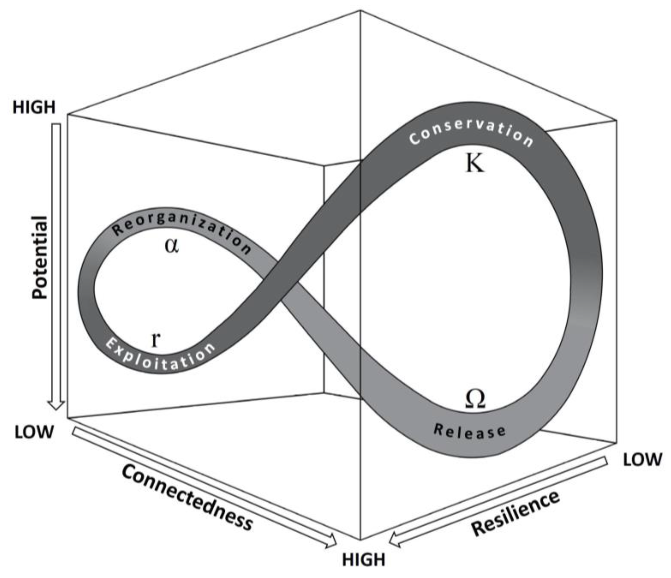
Table 1.
The matrix of social resilience, after Keck and Sakdapolrak [21] (p. 10).
Table 1.
The matrix of social resilience, after Keck and Sakdapolrak [21] (p. 10).
| Coping Strategies | Adaptive Strategies | Transformative Strategies | |
|---|---|---|---|
| Response to risk | Reactive | Proactive | Proactive |
| Temporal scope | Short-term | Long-term | Long-term |
| Degree of change | Low, seeking status quo | Medium, incremental change | High, radical change |
| Outcome | Restoration of present well-being | Security of future well-being | Enhancement of present and future well-being |
Table 2.
Agglomerated settlement sites occupied during each century.
| Century with Occupation | 300–400 | 400–500 | 500–600 | 600–700 | 700–800 |
|---|---|---|---|---|---|
| Number of agglomerated settlements | 16 | 17 | 18 | 15 | 8 |
Disclaimer/Publisher’s Note: The statements, opinions and data contained in all publications are solely those of the individual author(s) and contributor(s) and not of MDPI and/or the editor(s). MDPI and/or the editor(s) disclaim responsibility for any injury to people or property resulting from any ideas, methods, instructions or products referred to in the content. |
© 2023 by the author. Licensee MDPI, Basel, Switzerland. This article is an open access article distributed under the terms and conditions of the Creative Commons Attribution (CC BY) license (https://creativecommons.org/licenses/by/4.0/).
Share and Cite
MDPI and ACS Style
Munro, M. Resilience Thinking and Landscape Complexity in the Basentello Valley (BA, MT), c. AD 300–800. Land 2023, 12, 651. https://doi.org/10.3390/land12030651
AMA Style
Munro M. Resilience Thinking and Landscape Complexity in the Basentello Valley (BA, MT), c. AD 300–800. Land. 2023; 12(3):651. https://doi.org/10.3390/land12030651
Chicago/Turabian StyleMunro, Matthew. 2023. "Resilience Thinking and Landscape Complexity in the Basentello Valley (BA, MT), c. AD 300–800" Land 12, no. 3: 651. https://doi.org/10.3390/land12030651
Note that from the first issue of 2016, this journal uses article numbers instead of page numbers. See further details here.