

How Effective Risk Assessment and Management Is the Key to Turning Volcanic Islands into a Source of Nature-Based Solutions

1
Geosciences Barcelona, Consejo Superior de Investigaciones Científicas (CSIC), Lluís Solé y Sabarís, s/n, 08028 Barcelona, Spain
2
Department of Earth and Ocean Dynamics, Earth Sciences Faculty, University of Barcelona (UB), Martí i Franquès, s/n, 08028 Barcelona, Spain
3
TOSCA S.L. Olot, 17800 Girona, Spain
*
Author to whom correspondence should be addressed.
Land 2023, 12(3), 686; https://doi.org/10.3390/land12030686
Submission received: 15 February 2023
/
Revised: 10 March 2023
/
Accepted: 11 March 2023
/
Published: 15 March 2023
(This article belongs to the Special Issue Planning Sustainable Cities through Nature-Based Solutions)
Abstract
:Active volcanic islands are particularly vulnerable to multi-risk natural hazards, many of which are anticipated to become more severe as a result of climate change. It is crucial to create and put into action adequate risk mitigation plans based on comprehensive long-term hazard assessments that include nature-based solutions in order to improve societal safety on these islands. Herein, we study the case of Tenerife. After a compilation and analysis of the potential resources of this island, as well as a study of its main natural hazards and how they are currently managed, we have determined that the most viable solutions are nature-based ones. Land management based on prior assessment of the island’s hazards is the key to strengthening Tenerife’s current risk mitigation plans. This will allow for a two-way relationship between the exploitation of sustainable tourism and the education of its population, both oriented toward the conservation of its geological heritage, and will promote the sustainable use of the energy and material resources currently being exploited. This contribution thus establishes the pillars from which to exploit the nature-based solutions offered by Tenerife as the only viable option for its sustainable economic development.
1. Introduction
In modern society, nature-based solutions are necessary to inform policies on biodiversity conservation, climate change adaptation and mitigation strategies, and the sustainable use of natural resources, among other issues [1,2,3,4]. They are defined by the European Commission [1] as “actions inspired by, supported by or copied from nature; both using and enhancing existing solutions to challenges, as well as exploring more novel solutions, for example, mimicking how non-human organisms and communities cope with environmental extremes”. In this sense, they address societal challenges through the protection, sustainable management, and restoration of natural and modified ecosystems, for the benefit of biodiversity and human well-being. They focus on major challenges, such as anthropogenic climate change, disaster risk reduction, food and water security, biodiversity loss, and human health, and are essential for sustainable economic development. Policies such as these should apply to all aspects of society, but they are particularly relevant for volcanic areas, where extreme hazards, natural resources, and socio-economic implications combine.
Active volcanic areas are subjected to the constant threat of eruptions, which may have highly devastating effects. However, they also offer a number of important advantages that have made them so attractive for human settlements throughout history. More than 80 percent of the Earth’s surface—including both above and below sea level—is of volcanic origin. Volcanoes are responsible for the magnificent landscapes and fertile soils that provide the essential basis for the development of some of the richest ecosystems on Earth [5]. Furthermore, they are the source of important energy and mineral resources that remain vital for the development of societies (e.g., [6]). This is even more relevant in our modern globalized society, in which certain technological requirements (e.g., mobile phones, computers, etc.) contain primary elements derived from volcanic products. Volcanoes also offer an unavoidable attraction for nature tourism interested in visiting places where active geological processes can be observed (e.g., [7]). These positive aspects sometimes cause societies living around active volcanos to ignore or underestimate their risks. This disequilibrium between potential economic benefits and the perception of potential risks is often the cause for turning volcanic eruptions into disasters, as the obvious income may reduce the perception of risk to levels at which the necessary prevention and preparedness actions vis-a-vis volcanic threats are simply ignored.
Generally, humans and volcanoes are not incompatible, but living near volcanoes implies knowledge of how they work and, therefore, when they may represent either a risk or a benefit. To minimize the risk from active volcanoes, it is important to first conduct a long-term hazard assessment, which will inform us on the spatial and temporal probabilities of volcanic and associated hazards [8]. This will constitute the basis for correct land use planning in the area toward an adequate risk management plan. It will also permit implementing the necessary mitigation actions and will help those concerned to think about the importance of constraining the potential benefits and their associated risks, prior to a development action plan.
Due to their natural isolation and strong dependence on external supply chains, volcanic islands tend to have fragile economic systems and are thus comprised of highly vulnerable communities, with their main monetary incomes coming from the tourism industry and local economic activities, such as fishing (e.g., El Hierro, Canary Islands, Spain; Iceland) or viticulture (e.g., Pico Island, Azores, Portugal).
Volcanic islands are created by the growth of oceanic volcanoes having evolved and been modified by geological, biological, and human activity. Volcanic islands can be affected by multiple natural hazards; these can be meteorological (e.g., hurricanes or typhoons) or geophysical (volcanic eruptions, earthquakes, landslides, tsunamis, etc.) events, as well as secondary hazards, such as forest fires, droughts, floods, etc., which have been induced by weather and/or volcanic events. In some cases, these can be triggered, amplified, or exacerbated by processes driven by Climate Change (e.g., changes in atmospheric conditions, sea level rise, coastal erosion, glacial melting, etc.). In addition, the continuous demographic expansion of many volcanic islands, caused mainly by the steadily increasing tourism, is a critical factor that exponentially increases the risk in such environments. Moreover, the latest climate models for this century project increases in the number and intensity of storms and hurricanes, as well as significant sea level rise [9]. These phenomena will increase the vulnerability of coastal areas on volcanic islands. These hazards can often act simultaneously or in a concatenated way, leading to unpredictable cascading effects. Such events may not only affect the islands’ natural ecosystems, but also may temporarily suspend touristic and local industrial activities in the area (e.g., fishing), leading to serious, and in some cases irreversible, economic contraction.
This contribution explores and determines the potential for establishing nature-based solutions to contribute to disaster risk mitigation strategies and policies that are compatible with economic activities, and which accommodate demographic expansion, future effects of climate change, and sustainable development on volcanic islands. Through the analysis of the volcanic island of Tenerife as a particular case study, we seek alternative solutions for areas with a great geo-conservation and geo-tourism potential. This is especially important for areas that have been abandoned due to their potentially high risk and without considering adequate territorial planning aimed at reducing such risk, while favoring higher economic potential. We propose a series of opportunistic actions for land management, founded on long-term nature-based solutions that will allow increasing resilience against future risk scenarios.
2. Main Geological, Geographic, and Socio-Economic Characteristics of Active Volcanic Islands—Tenerife as a Case Study
Active volcanic islands are located all around the world. Despite the intrinsic direct and indirect hazards associated with them, many volcanic islands are densely populated. This is because of the important benefits associated with volcanoes, which can take the form of rich soils, available energy and mineral resources, and rich landscapes and ecosystems, etc. In recent years, an emerging prosperity associated with active volcanoes has come from tourism, which in many places already represents one of their main incomes. To this end, knowing how volcanoes work and how we can reduce their associated risks is of the utmost importance for preserving the safety of citizens and visitors living near them.
Volcanoes represent the culmination of complex geological processes that involve the generation of magma at depth; its rise, accumulation, and differentiation in shallower reservoirs; and finally, its appearance at the Earth’s surface in the form of volcanic eruptions. Eruptions may generate a large diversity of products (lava flows, pyroclastic fragments and deposits, and gases) depending on the characteristics of each eruption (effusive or explosive), and they may also leave signs of its potential future activity in the form of thermal anomalies, fumaroles, hydrothermal alteration, etc. The solid products of volcanism (lavas and pyroclastic deposits) tend to accumulate around volcanic vents, but may also extend to distal regions depending on the magnitude and intensity of the eruption. Depending on the magma composition, most of these products are very rich in chemical components that, when under adequate climate conditions, may transform into fertile soils.
Active volcanic areas—and so, volcanic islands among them—tend to generate very diverse landscapes, which depend on the style of volcanism. These are mostly demonstrated by large and steep stratovolcanoes (composite or polygenetic volcanoes) or relatively flat areas containing a diversity of small volcanic cones and lava fields (monogenetic volcanic fields) [10]. In any case, the landscape is modulated by the presence of this volcanism and subsequent morphological agents (erosion, weathering, sedimentation, etc.), and depending on climate conditions, it will constitute the basis for the development of diverse ecosystems.
Volcanic hazards are inherently complex and, therefore, difficult to predict due to their intrinsic multi-factor nature, in which different volcanic products (lavas flows, fallout, lahars, and pyroclastic flows) and associated hazards (seismic shocks, landslides, tsunamis, and floods) interact or impact together or sequentially [8]. Hence, when evaluating the potential impact of volcanic eruptions, we must identify what direct and indirect hazards can be derived in each case and develop knowledge of their cause–effect relationships. Volcanic eruptions span a broad diversity of hazards that directly derive from the volcanic activity (e.g., lavas flows, fallout, pyroclastic density currents (PDC), lahars, gases, etc.), as well as indirect hazards triggered by the action of the direct hazards (debris flows, rock avalanches, seismicity, tsunamis, etc.). Eruption durations are known to be very variable, ranging from a few hours to several years, with sizes ranging from a few millions of cubic meters to several thousands of cubic kilometers, and may involve very distinct phases, from effusive to highly explosive, generating a variety of products. These products result from different dynamics and emplacement modes and so will generate different potential hazards (e.g., [8,11]). These variations in volcanic eruptions and their products and, consequently, their potential impacts, depend to a large extent on magma composition, which controls its rheology and volatile content. Therefore, the impact of a volcanic eruption will depend on its size, which determines the extent of its erupted products. The impact is also dependent on the type of products generated and the degree of hazard they may represent. In this sense, PDCs, lava flows, and lahars are considered the most destructive products, but fallout and gases may also have important implications in proximal areas [11,12,13]. The reconstruction of the eruptive history of a volcano, together with a comprehensive understanding of the physics of volcanic processes, allows us to identify eruptive scenarios. This, in turn, allows us to determine which have been the most frequent in the past and, hence, to estimate the probabilities of future eruptions. This is the essence of volcanic hazard assessment [8].
Despite the risks associated with active volcanoes, the richness of volcanic areas has always attracted human settlements, which have evolved and progressed, despite suffering the impact of their eruptions from time to time. Many societies that have developed around volcanoes have demonstrated a high degree of resilience and adaptation, successfully recovering after each volcanic impact (e.g., [14]). The socio-economic development of the different societies around volcanoes is diverse and ranges from very poor societies, where people get just enough to survive on a daily basis, to rich societies, where part of their wealth comes from the extraction of natural resources (energy and minerals) associated with volcanoes. However, in all cases, it is the very existence of volcanoes that determines their socio-economic development. Moreover, in recent years, a direct source of income has emerged: nature tourism, with tourists becoming increasingly interested in visiting active volcanoes, even in remote and underdeveloped areas. This effect has been particularly noticed on volcanic islands (e.g., [15]). Therefore, by mitigating volcanic risks, we transform the effects of volcanoes using nature-based solutions. This approach works to sustainably strengthen and enrich all these societies, which, in one way or another, rely on active volcanoes for their subsistence.
2.1. Tenerife
Tenerife is the largest of the eight islands that make up the Canary Islands (Spain), an active intraplate volcanic archipelago located in the Atlantic Ocean off the coast of northwest Africa (Figure 1). With its more than 8000 m above the sea floor, it is the second largest volcanic structure in the world, after Mauna Loa in Hawaii. Tenerife has experienced several major eruptions in historical times, all corresponding to basaltic volcanism, the last being the Chinyero eruption in 1909. In addition to being a very important tourist destination (it receives an average of 4.5 million tourists per year), it is also the scene of multiple hazards that cause annual economic losses and sometimes even the loss of human life.
2.1.1. Geological Context
The Tenerife basaltic shield started to ascend from the ocean floor at least 12 Ma ago, and its construction has continued until the present, now extending across two rift zones (Santiago Rift Zone and Dorsal Rift Zone), as well as across a broad monogenetic volcanic field to the south of the island (Figure 1) [16,17,18]. This basaltic shield is mostly submerged and forms about 90% of the volume of the island. After a slowdown in its formation, which was affected by a subsequent significant erosive period (about >3.5 Ma) [17,19], a period of more intensive phonolitic volcanism alternating with basaltic episodes began in the center of the island. This led to the formation of a central complex (Las Cañadas edifice, between 4–0.18 Ma) [17,19,20,21], a composite volcano mainly formed of the products of explosive eruptions from highly evolved phonolitic magmas. The evolution of Las Cañadas Edifice includes several cycles of phonolitic volcanism that ended with a caldera collapse episode, which together formed the Las Cañadas caldera, in which the active twin stratovolcanoes Teide and Pico Viejo stand [20,22]. Teide and Pico Viejo include a complete series from basanite to phonolite and are mainly characterized by effusive volcanism—but in the last 30 ka, significant explosive activity related to phonolitic magmas has also occurred [23,24].
![Land 12 00686 g001]()
Figure 1.
(a) Simplified geological map of Tenerife (modified from [23]), (b) stratigraphy of Tenerife, and (c) schematic cross-section of the island. Las Cañadas caldera wall localities: EC-El Cedro; BT-Boca Tauce; U-Ucanca; RDG-Roques de García; G-Guajara; LA-Las Angosturas; LP-Las Pilas; DH-Diego Hernández; EP-El Portillo; LF-La Fortaleza. Main vent systems of the Teide–Pico Viejo formation: PT-Teide volcano; PV-Pico Viejo volcano; MB-Montaña Blanca. Post-shield mafic volcanic zones: SRZ-Santiago rift zone; DRZ-Dorsal rift zone; SVZ-Southern volcanic zone (locally known as Bandas del Sur). Names and locations of landslide valleys are also shown. Contour interval is 200 m. Isotopic ages are from [17,20]. Inset map shows the location and distribution of the Canary Islands. Main islands: LP-La Palma; EH-El Hierro; G-La Gomera; T-Tenerife; GC-Gran Canaria; F-Fuerteventura; L-Lanzarote. Source: [25] (CC BY-NC-ND 4.0).

As on other volcanic islands, the evolution of Tenerife is characterized by the existence of constructive (accumulation of volcanic materials) and destructive episodes (caldera collapses, sector collapses, and erosion). Large-scale sector collapses and subsequent erosion have modulated three important morphological depressions affecting the northern and southern flanks of the island, the Güímar, La Orotava, and Icod valleys (Figure 1). The products of Teide and Pico Viejo mostly infill the Las Cañadas caldera depression, but also an important part of the Icod and La Orotava valleys. Furthermore, recent basaltic volcanism has contributed to partially infilling these depressions.
2.1.2. Socio-Economic and Political Context
According to the Instituto Canario de Estadística (ISTAC), Tenerife closed the year 2021 with a population of approximately 927,993 inhabitants, making it the most inhabited island of the entire archipelago [26]. It has a constrictive population, with a low percentage of young people and, therefore, decreasing birth rates (Figure 2a). However, the general trend has been one of a growing population over the last two decades (Figure 2b).
In the island territory, the ISTAC identifies two main urban centers, Santa Cruz de Tenerife-San Cristóbal de La Laguna (northeast) and Puerto de la Cruz-Los Realejos (north) (Figure 3). This category corresponds to a minimum population density of 1500 inhabitants/km2 and a minimum population of 50,000 inhabitants. However, the majority of urbanization corresponds to semi-dense urban agglomerations, i.e., with a minimum density of 300 inhabitants/km2 and between 5000 and 49,999 inhabitants. The remainder corresponds to dense urban agglomerations (≥1500 inhabitants/km2 and between 5000 and 49,999 inhabitants), rural and low-density conglomerations (≥300 inhabitants/km2 and ≥50 inhabitants/km2, respectively, but in isolated nuclei without contiguity), and urban periphery (≥300 inhabitants/km2 and 500–49,999 inhabitants) [26].
To this, we must include a tourism industry that adds between 4 and 4.5 million visitors every year (except in 2020, due to COVID-19 restrictions) over the last decade. This tourism is especially concentrated in July, followed by August, whose overnight stays are focused in the municipality of Adeje (southwest), followed by Puerto de la Cruz (north) [26].
For that reason, and according to the ISTAC [26], Tenerife’s economy is mainly based on the Services sector, which contributes nearly 78% of the island’s Gross Domestic Product (GDP). Commerce, transportation, lodging, and communications account for 32% of the total GDP of the island, totaling almost EUR 6.5 billion. Construction, on the other hand, contributes nearly 6% of Tenerife’s GDP, ahead of industry at 5%. Agricultural activity on the island, with a cultivated surface area of some 16,000 hectares—some 10% of the island’s territory—generates 1.7% of the GDP.
3. Methodology
Our aim was to identify the opportunities for volcanic islands to establish nature-based solutions that contribute both to risk mitigation and to their sustainable development. For this, we started by analyzing and outlining the main requirements for these particular areas, mainly considering risk derived from volcanic hazards, despite many other natural and anthropogenic hazards that may impact these highly vulnerable environments. We first considered what must be known about volcanoes and their eruptions and how they may be characterized in a hazard assessment context. For this purpose, the reader is provided with a summary of this procedure based on a compilation and review, on the basis of expert judgement, of literature from other authors and ourselves. The literature used is based on previous works that have carried out long-term hazard assessment, which also explain as results of these studies how this methodology should be used. From the extraction and summary of the information contained in these works, we defined the actions that need to be undertaken in any active volcanic region before considering land planning and the exploitation of its resources.
Next, we considered how hazard assessment can be implemented into a development plan for these regions, paying special attention to territorial planning, implementation of mitigations measures, and the development of emergency plans. From an extensive revision of the existing bibliography, we extracted the essential elements that a disaster risk reduction program should consider, together with a series of recommendations that are applicable to volcanic regions with similar potential problems.
Next, we consider Tenerife as a case study of a volcanic island with a great potential for implementing nature-based solutions, with the goal of reverting the development policies applied until now by local and regional authorities. We started with a compilation of the main events that the island has experienced in historical time (i.e., since 1492). For this purpose, we consulted historical documents from the Provincial Historical Archive of Santa Cruz de Tenerife and the Municipal Archive of San Cristobal de La Laguna, as well as the landslide database of the Spanish Geological and Mining Institute (IGME) and the seismic catalogue of the National Geographic Institute (IGN). In addition, we revised an extensive bibliography of previously made catalogues, which served as a basis for updating and completing the historical records and for unifying data from different sources. With this, we have summarized the main natural hazards to which Tenerife has been, is presently, or may be exposed to in the future. We place special emphasis on the hazards associated with volcanic eruptions, also considering the extreme events that have occurred over geological time (i.e., prior to the historical record) and which could, therefore, reoccur in the future.
Moreover, we carried out an analysis of the resources of the island. Due to its beneficial climatology and hours of sunshine, tourism and agriculture offer the greatest potential, and in relation to this, we have also compiled a database of energy infrastructure on the island, as well as other economic activities that support the region. Finally, geological heritage, together with biological and cultural heritage, was also considered.
The next step was to study the island’s territorial planning and land use. For this purpose, we studied the Tenerife Island Management Plan (available at https://www.tenerife.es/portalcabtfe/es/temas/ordenacion-del-territorio/el-planeamiento-territorial-y-urbanistico/plan-insular-de-ordenacion-de-tenerife/49/800, accessed on 12 December 2022), and we have identified the urban distribution and communications network patterns in relation to topographical and geological elements. In addition, we have summarized and described in detail the protected areas and the variety of landscapes offered by the region, highlighting the geological heritage of the island and its relationship with the tourism sector.
The information derived from protected areas, geological hazards, and geological heritage has been unified and correlated. This allowed for the identification of different places that are under some type of protection, in addition to the sustainably exploitable geological interests they possess and what sensitivity they have to geological hazards. The aim is, thus, to improve the management of the island’s geological resources with territorial planning that is focused on risk mitigation customized for each area.
Finally, we explored the risk management mechanisms that Tenerife and its political structure have at the local, regional, and national levels. For this purpose, we consulted the different emergency plans for certain natural disasters, published on the website of the Cabildo de Tenerife (https://www.tenerife.es/portalcabtfe/?lang=es, accessed on 21 December 2022).
This provided a global and general vision of the sustainable development opportunities and fields to be explored, both from an economic and risk mitigation point of view. The understanding of the current state of Tenerife society and the multi-hazardous nature of the island, as well as its future trends, has enabled identification of nature-based solutions that this region can offer in order to cope with demographic expansion and the growing exposure of the population to natural risk. To that end, the text herein offers solutions, alternatives, and strategies to improve the resilience of Tenerife’s population.
4. Results
4.1. Volcanic Hazard Assessment and Hazard Map
Long-term volcanic hazard assessment is based on historical and geological data and is principally used for territorial planning and for defining emergency plans. It uses quantitative analysis of past volcanic activity, including its structural and petrological controls, and aims to determine the physical volcanological parameters of past eruptions, such as to model possible hazards and eruption scenarios that may repeat (Figure 4) [8,27,28]. Long-term volcanic hazard assessment calculates the spatial and temporal probability that a new volcanic event will take place and characterizes its resulting impacts. Therefore, hazard assessment must identify the main physical mechanisms that control the predicted phenomena. In this way it aims to determine a given volcano’s extent, potential impact, and destructive capacity, while placing temporal constraints on the framework in which they occur (e.g., [8,13]).
Spatial analysis aims to determine the position of new vents based on knowledge of past eruptions, the existence of structural controls on vent distribution, the characterization of products from previous eruptions, and their spatial interrelations [29,30,31,32]. This information will provide the basis for establishing the vent opening probability (i.e., volcanic susceptibility) and the probability of invasion (i.e., laterally and longitudinally) by new eruptive products. Temporal analysis supports spatial analysis by establishing relative eruption times (volcanic stratigraphy) and, whenever possible, its geochronology by means of radiometric dating. This enables one to identify temporal eruptive behavior patterns of the volcanic system, such as clusters of eruptions or episodes of quiescence between eruptions; if absolute ages are available, the eruption frequency or recurrence (i.e., the temporal probability of an eruption) can be estimated, as well (e.g., [28]).
As previously mentioned, a volcanic eruption may encompass several phases and pulses, each giving rise to different products. For example, an eruption may produce a Plinian column, which generates units of fallout deposits and then, as it collapses, produces PDCs of differing characteristics. The deposits produced by each phase or pulse will exhibit different lithological, sedimentological, and stratigraphic characteristics, and will be distributed across different sites around the volcano. Plinian fallout deposits will be widely distributed and will tend to blanket the surrounding topography, while PDC deposits will habitually accumulate in low-lying areas. After deposition, eruptive products may be affected by other geological processes (e.g., erosion, reworking, and resedimentation), forming secondary volcanic deposits. Primary and secondary deposits from a particular eruption that appears in the geological record may exhibit complex stratigraphic relationships that depend on the characteristics of the eruption, in addition to its topography and eruptive environment.
As part of the long-term volcanic hazard assessment, the construction of hazard maps is essential to land planning and emergency procedures, as well as for conducting risk analysis and to identify communities exposed to the greatest risks [33,34]. Nowadays, a hazard map is a dynamic concept that differs from the classical static maps that were drawn under the assumption that no changes will occur over long periods of time. A hazard map may change as new information becomes available, as the accuracies of simulation models improve, due to revisions of cartographic and geographic data, or as new eruptions occur [8,35]. Thus, the methodologies and concepts used to construct hazard maps must bear in mind the fact that a map is a temporary and open-ended product that is continuously evolving [36]. Hazard maps are usually probabilistic (both spatially and temporally) and may be constructed for just a single hazard, for groups of hazards, or for all the hazards forecasted for a particular area and over a particular time window. They may be qualitative or quantitative, and may cover certain restricted areas or a whole volcanic field [34,35,36,37]. Previously, hazard maps were constructed using information pertaining to past events, and so the resulting map was basically lithostratigraphic cartography of the products of past eruptions, in which the emphasis was placed on their superficial extent. However, modern hazard maps are constructed using GIS and computational facilities and represent what could happen if similar eruptions to those that have occurred in the past take place again [35,36]. They, therefore, describe areas that may be affected by each hazard, the degree of affectation or impact, and the potential risk. Hazard maps constitute the main tool for illustrating and visualizing how a territory can be classified according to the degree of hazard to which it is exposed; they are, hence, very relevant tools for territorial management. However, they are also highly useful for illustrating and communicating the geological reality to decision makers and the population in general, and they provide an actionable framework in which to respond in the event of an eruption [37].
Another important aspect to be considered when trying to understand the potential risk of an active volcanic area is that volcanoes are intrinsically multi-hazard systems, since they generate different hazards (lavas flows, PDCs, fallout, lahars, debris avalanches, earthquakes, etc.), while they may be the cause or the effect of other hazards (earthquakes, floods, landslides, tsunamis, etc.). This has significant implications when conducting hazard assessment and, consequently, land planning and risk management. Therefore, volcanic hazard maps need to be precise, and they must constitute the basis on which to build possible nature-based solutions for these regions. The application of long-term volcanic hazard assessments to land use planning will permit identification of each area according to its degree of risk and the type of hazards that may impact there. Furthermore, it will facilitate decision making on the types of development activities that could be undertaken there. This must be done in accordance with a risk management plan, which should be a requirement of primary importance for the development of a particular society.
4.2. Risk Management, Risk Mitigation, and Nature-Based Solutions
Volcanoes may have significant negative consequences on human populations, their economies, and the environment, which may then require long psychologically, physically, and economically difficult periods of recovery [13,14,38]. Thus, despite their potentially high cost, investment in risk-reduction programs is always preferable to merely reacting once disasters have struck [13]. The cost of prevention and mitigation actions is always lower than the cost of recovery, particularly when a catastrophic event hits a place that has not invested in risk reduction (e.g., [39,40]). This is the main message that needs to be transmitted to policy makers. Moreover, there is the fact that a safe area is much more attractive than a dangerous one.
An overall risk reduction plan should include several essential programs (Figure 5): (1) a scientific program aimed at improving knowledge of the process and its potential impacts (i.e., hazard assessment); (2) a monitoring program for determining the current state of activity of the process; (3) an educational program to educate the population about the potential hazards and risks that threaten them; and (4) a management program for designing customized emergency plans and resilience strategies for specific locations. Long-term hazard assessment is the first task that a society threatened by volcanoes needs to undertake if it aims to live with volcanoes and take advantage of what they offer (majestic landscapes, productive soils, mineral and energy resources, etc.). The impact of disasters caused by eruptions significantly increases when societies are not prepared to cope with volcanic threats—or they simply ignore them. Erroneous land planning, a lack of emergency plans, and poor knowledge of volcanic hazards and risks—not only amongst the general population, but also amongst decision makers and even scientists—may convert a natural event into a disaster [8].
Volcanic risk management should undertake not only those actions necessary to cope with a volcanic crisis, but also those mitigation actions aimed at reducing risk in the area. Among others, these should include structural measures (e.g., vulnerability analysis and engineering solutions), emergency management actions, and land use planning. Land use planning should be based on the long-term hazard assessment and should consider the most appropriate measures to guarantee the security of citizens and by obtaining the maximum resources that the land can provide, and restricting land use when necessary. However, this is not an easy task, and a number of challenges appear when dealing with land use planning in active volcanic areas. The uncertainty over the timing, magnitude, and impact of future eruptions constitutes the main obstacle. This is because policy makers tend to be reluctant to make decisions over the long term, particularly when these are based on scientific assumptions that are not exempt from high uncertainties and may have inconvenient or disruptive political or economic implications (consequences) to their interests. This is why it is important for scientists to convince policy makers of the fact that prevention and preparation is always preferable to reaction, particularly when dealing with volcanoes, with their complex multi-hazard systems that can be forecasted over the long-term and, increasingly, also in the short-term. Sometimes, restrictions are imposed by scientists when they are unable to sufficiently explain to the population and policy makers about hazards and risks, or about the convenience and (long-term) benefits of adequate land use and risk mitigation planning. Therefore, risk management is a task that needs to involve all stakeholders of an affected society. We must collectively aim to understand and accept their risks and potential consequences, taking a proactive stance going forward. Scientific uncertainty in forecasting volcanic events is not a sufficient excuse for inaction, and even less so when it is a question of when, not if, a volcano will erupt.
In addition, to ensure that hazard assessment and vulnerability analysis are adequately addressed within policy statements and plans, one way to make risk reduction plans understandable and acceptable in active volcanic areas is by proposing nature-based solutions—for example, in the case of deciding whether new developments should be permitted in areas identified as high risk. While the authorization of new permanent constructions may be questionable, it could be that the development of certain activities that facilitate observation of the natural environment (even the temporary use of the land) should always depend on the degree of volcanic activity, as well as the expediency of emergency plans, in case of unforeseen activity. Further, we recommend to undertake planning for other land use recovery aspects by considering what the effects of an eruption might be, how land use could be improved after an event, and what steps might be taken before an event to ensure such improvements can be made [42]. In fact, volcanism does not need to be incompatible with certain types of activities and land uses if these are based on precise knowledge of the risk in each case.
The application of nature-based solutions to the sustainable development of volcanic areas (especially to volcanic islands) is sufficiently broad to involve numerous contributions. The list of possible nature-based solutions may include: (1) the sustainable use of raw materials, (2) geothermal energy production, (3) sustainable soil management for agriculture, (4) ranching, (5) for use in construction, (6) landscape solutions that are resilient to climate change (e.g., reducing flood risk, erosion, etc.), and (7) the promotion of safe and sustainable nature-based tourism, among others. However, the number of these potential solutions that have already been applied in volcanic areas is still low and rather unequal, depending on the characteristics of each area (e.g., local economy, social development, political system, risk perception, etc.).
In most active volcanoes and volcanic areas, it is common to find protected natural spaces [43,44], either because of the rich soils that generate high biodiversity, because of their scenic beauty, or because of their geological heritage. For example, of the 100 sites that have been declared as having geological interest by the IUGS (International Union of Geophysical Sciences), 27 are active volcanic areas or are related to volcanism. These protected natural spaces, if they are well-managed, generate social and economic improvement [45], as well as awareness and knowledge of geology, for both the local population and their visitors. In addition, the promotion of volcanic geoheritage is an efficient way to enhance the development of poor and rural regions by educating their inhabitants on its geological richness and how to benefit from preserving it and exhibiting it to others. This nature-based solution is important in two senses. It will help local residents value their area and, hence, see the need for preserving this value, and it will lead them to organize new businesses around rural tourism. In addition, such a solution will help create a community conscience around the need for preserving their geological values and related ecosystems, and to be aware of potential risks that may affect their area. In the following section, we analyze the case of Tenerife (Canary Islands) and then discuss the possible application of nature-based solutions to solve some of the problems it presents.
4.3. The Case of Tenerife
4.3.1. Volcanic and Other Natural Hazards
The island of Tenerife has been the scene of both extreme and non-extreme events throughout its evolution. Its natural characteristics, seen by its topography (steep slopes and significant elevations, especially in the central part, reaching 3718 m at the peak of Teide), its geology (varying volcanic terrains, such as lava flows; pyroclastic products, such as ash and pumice fallout deposits; pyroclastic flow deposits; etc.; as well as other sedimentary rocks), or its geographic location, make it an area susceptible to different natural processes that not only modify its morphology, but can also seriously affect its society. However, the overexploitation of resources, massive tourism, and the expanding overpopulation that the island suffers from can aggravate the consequences of such phenomena. Meteorological phenomena, geological processes, and anthropogenic actions all work to modify the relief and give rise on numerous occasions to interrelated natural disasters.
Volcanic eruptions have been relatively frequent on Tenerife in recent time, with about 18 phonolitic eruptions during the Holocene from the Teide and Pico Viejo volcanoes [23,24], and more frequent basaltic eruptions, mainly from the rift zones—a total of six in historical times [46,47]. All the historical eruptions of the island, since written records began, which in Tenerife dates back to 1492, have been preceded by earthquakes, which have continued to occur during and after the eruptions [48]. The first eruptions of which there are historical records are those of Arafo (or Arenas), Fasnia, and Siete Fuentes, which occurred between 31 December 1704 and 27 March 1705 [49]. (Previously, Christopher Columbus in 1492, on his way to the Americas through the Canary Islands, described what could have been an eruption in the Boca Cangrejo volcano, but these facts are still being questioned.) On 5 May 1706, the eruption of Garachico or Arenas Negras began and lasted until 13 June of the same year. From 9 June to 15 September, the eruption of Chahorra (or Narices del Teide) took place, and the last eruption that the island experienced was that of Chinyero, from 18 to 27 November to 1909 [49]. As can be seen, these eruptions have not lasted more than three months. However, being events that trigger multiple hazards, the direct and indirect effects are diverse. These eruptions have caused ash falls that have affected crops and water reserves, in addition to the collapse risk of building roofs. The lava flows devastate everything in their path and have sometimes caused fires, in addition to the emission of gases, which are also released from the mouth of the volcano. These eruptions usually have an explosive component, so the projection of different sized pyroclasts (lapilli, bombs, in addition to the ash already mentioned) is common, with the risk of direct impact. Moreover, the associated seismicity can also cause damage to buildings and infrastructure and generate panic among the population.
In addition, during the construction of the Las Cañadas edifice, Tenerife experienced several cascading extreme events. This is the case of the La Orotava and Icod valleys, on the northern flank of Tenerife, two large sector collapses that coincided in time with the occurrence of caldera-forming episodes. They are coeval with the formation of the central (Guajara, 0.56 Ma) and eastern (Diego Hernández, 0.17 Ma) sectors of the caldera of Las Cañadas, respectively [25,50]. These sector collapses also generated large scale tsunamis [51]. Caldera eruptions ranged in size from 12 to more than 20 km3 of phonolitic magma, mostly in the form of pyroclastic material that had been deposited on the island and offshore [20,52]. The Icod and La Orotava landslides moved volumes of 240–264 km3, including subaerial and submarine materials [53]. The resulting tsunami left deposits that are preserved in thicknesses of 0.4–3 m on the northwestern flanks of Tenerife at altitudes up to 132 m a.s.l. [51]. Since the succession of events described here is a process that has repeated several times in the past, it is not inconsistent to consider that it might occur again in the future [25].
Furthermore, every year, more moderate natural events occur, which continue to put people and infrastructure on the island at risk. To begin with, there are floods and torrential avenues. These phenomena are usually triggered by storms, with heavy rains and winds, in addition to the effect that the waves have during these episodes in the most coastal areas. These events occur about once or twice a year, from October to December and from February to April. Heavy rains produce torrential floods in ravines bounded by steep slopes and escarpments, which characterize the volcanic terrain of the island. They usually overflow when they reach flatter areas or areas modified by human activity, either by channeling, bridges and narrowings, or changes along the course of the flow, or due to paving. The most affected cities are usually Santa Cruz de Tenerife, San Cristóbal de La Laguna, Garachico (especially by waves), San Andrés, the La Orotava Valley, Güímar, Puerto de la Cruz, Los Realejos, and Icod de los Vinos, among other municipalities [54]. In addition, these torrential floods drag large quantities of sediment along the ravines, which, added to the landslides caused, lead to the deposition of mud and large rocks in the overflow areas, thus increasing their impact and making cleanup and repair tasks more difficult. Some of the worst episodes were the floods of March 2002, which caused 9 deaths and losses estimated at EUR 120 million; the storm of January 1999, without deaths, but with losses of EUR 35 million; or some historical ones, such as the flood of November 1826, which caused around 500 deaths, around 1000 dead animals, and ESP 7,000,000 (i.e., pesetas; currently around EUR 42,000) of economic losses [55].
Other phenomena common in Tenerife are rock falls and small-scale landslides. These usually occur in road cuts or in the ravines themselves, only some of which are frequented by tourists. That is why they do not usually cause deaths or injuries, as well as no major damage or costs; however, it is worth mentioning the landslide that occurred in the Barranco del Infierno on 26 October 2015, causing a single death and four injuries; or the one of 1 November 2009 on the cliff of Los Gigantes, causing the deaths of two people who were on the beach of Santiago del Teide; or the landslide of 27 January 1947 that left five dead in Tacoronte [56]. They are usually caused by heavy rains and winds and/or floods, as described above. Another common cause is earthquakes.
Earthquakes felt in Tenerife usually have two origins: tectonic or magmatic. Earthquakes with a tectonic origin are usually associated with the transform fault that runs through the channel between the islands of Gran Canaria and Tenerife. In this area, which hosts the highest seismic activity in the Canary Islands, there are usually between 400 and 500 earthquakes per year below 2.5 magnitude, with only a little less than a dozen exceeding this limit [57]. The earthquakes felt in Tenerife since records have been gathered have had intensities between I and VI on the MSK-64 scale [58] and do not usually cause any damage. Some exceptional cases are the earthquake of 9 May 1989, with a magnitude of 5.0 and an epicentral intensity of 6.7, which caused some breakage of windows and displaced furniture in houses [59]. As for earthquakes of magmatic origin, they can occur in isolation or in seismic swarms, i.e., groups of numerous earthquakes of low to intermediate magnitude in the same place, related to the movement of magma or fluids.
Other hazards that occur on Tenerife are the haze, coming from the Sahara, which, in addition to respiratory problems, has sometimes been accompanied by plagues of locusts, as happened in 2004; forest fires caused by heat waves and/or human action (such as in 2007, which burned 15,000 ha) or are aggravated by the haze; or tsunamis, which are somewhat less common, having a record of a tsunami on 15 November 1911, although these data are not so solid, such as with the 1755 tsunami caused by the Lisbon earthquake, which is not clear that it had any effect on Tenerife. However, there can be no doubt that, being an island in the middle of the Atlantic Ocean, it can easily be affected by any tsunami that runs through this area.
4.3.2. Resources
Tenerife has a great variety of natural resources, especially because of its great geodiversity and geological heritage, e.g., [60,61,62,63]. Its geographical location not only makes it a strategic commercial point in the Atlantic, but also gives it several unique properties. The climate is subtropical oceanic on the coasts (very temperate and sunny during most of the year, with a little rainfall concentrated in the period from October to March, especially in the north–northeast). In the inland areas, the climate varies according to altitude and orientation: on the northeast-facing slopes, there is abundant rainfall, while on the rest of the island, rainfall is scarce (<250 mm/year on the coasts, and often even below 150 mm), giving rise to arid landscapes. Trade winds from the northeast predominate, which make the northern slope more humid, while the heat on the coasts during the summer is more temperate. The average temperature is between 20–25 °C, although with seasonal variations, and the sun is present practically all year round, with many hours of daylight per day.
Thanks to these climatological properties, the island has several photovoltaic parks (i.e., power stations) in the municipality of Arico (southeast) and some in Granadilla de Abona (south), with a total power of more than 300 kW, in addition to several more parks in the process of being approved for the same municipalities and for Arona (southwest) [64]. This same area on the southeast coast of the island has several wind farms and several more planned. On the other hand, the volcanic materials provide the soil with a great variety and quantity of nutrients that are ideal for the crops grown there, especially bananas, as well as tomatoes, potatoes, and grapes. These volcanic materials are also used as building materials in what the island seeks to be sustainable architecture. The main materials exploited are ignimbrites, as ornamental or facing stones, and the main quarries are located at the south of the island, such as Cantera Guama-Arico S.L. (Arico, southeast, Figure 3).
The topography of the island, which causes significant variations in altitude, together with the consequent distribution of rainfall and winds, leads to the existence of a wide variety of ecosystems and unique landscapes in a small area. This has caused the island to have abundant and diverse flora and fauna. This biodiversity, together with the existing geological heritage, turns these natural resources into an important tourist resource that sustains the regional economy.
4.3.3. Land Use Planning
Among the duties of the Council of Tenerife, the administrative body of the island, is the protection of the environment; the management and conservation of protected natural spaces, forestry services, livestock trails, and pastures; the subrogation in the municipal duties to urban planning; and the approval of the Insular Plans of Works and Services elaborated in collaboration with the town councils of each island.
The island’s land uses are divided into urban areas, agricultural areas, environmental protection areas, and territorial protection areas (Figure 6) [65]. Regarding the first use, the metropolitan area of Santa Cruz-La Laguna (northeast); the tourist centers of Puerto de La Cruz (north) and Los Cristianos and Las Américas (Arona, southwest); and the industrial and tertiary urban areas of Güímar (east), Granadilla de Abona (south), and Santa Cruz de Tenerife (northeast) are worth mentioning (Figure 3). The entire urbanized area, which would include the categories described in Section 2.1.2 above, is distributed peripherally around the central part of the island, where Teide National Park (TNP) is located, (Figure 6) and, therefore, the central depression of the Caldera de las Cañadas, which houses the Teide–Pico Viejo volcanic complex (Figure 1). The main areas of future growth of the island highlighted by the Tenerife Island Land Management Plan (PIOT) are the metropolitan area of Santa Cruz-La Laguna, the Orotava Valley (north), and the southern zone comprising Las Américas-Los Cristianos (Arona) (Figure 3).
The distribution of communication routes follows this same peripheral pattern, except for a few roads that reach the two main entrances to this central depression—one to the southwest and the other to the northeast, joined by a road that crosses the Caldera de las Cañadas (Figure 3). According to the PIOT, there are two levels of the road and transport network. The basic level network, made up of what are known as island corridors, corresponding to the TF-1 highway, which runs along the entire south from west to northeast; the TF-5, which runs through the northeastern half of the island; the TF-2 that joins both in the east; and a whole series of roads that connect all the towns closest to the coast around the island. In addition, there is the intermediate level network, composed of county roads and complementary local roads that, following the same ring distribution, connect the rest of the municipalities.
In terms of facilities and infrastructure, the island has two airports, Los Rodeos in the northeast and Reina Sofia in the south, as well as three ports, Santa Cruz in the northeast, Granadilla in the south, and Fonsalía in the west (Guía de Isora municipality) (Figure 6). It also has two hospital complexes and health care partners, one in the north and the other in the south, and a further health facility complex in the Orotava Valley. Santa Cruz de Tenerife is also the administrative center of the island, as it is home to several political and administrative bodies (such as the Parliament, Government of the Canary Islands, Cabildo Insular). In addition, in Tenerife, there are four thermal power plants located in Candelaria (fuel oil/diesel, which are in the process of being dismantled), Granadilla de Abona (fuel oil/diesel), Santa Cruz de Tenerife (fuel oil, next to an oil refinery, both in the process of being dismantled), and Arona (diesel).
In contrast, the land for agricultural use is configured in a ring at the base of the central volcanic edifice, divided into the coastal part, with intensive crops, and the inland part, with traditional crops (Figure 6). Separately, the environmental protection areas include most of the forest areas in the central part of the island, the TNP, declared on 22 January 1954, spanning 18,990 ha, and the surrounding forest crown, the two extreme massifs (Anaga and Teno), and the rest of the Protected Natural Spaces. Finally, the territorial protection areas are those considered to be land reserves for the future, which preserve the vacant territory as a fundamental resource, the main ones being Las Américas and the northern midlands.
The high diversity and uniqueness of its landscapes, ecosystems, and natural resources, among other features, have provided Tenerife with an extensive network of protected natural areas (Figure 6). More than 50% of the island is protected as a natural monument, nature reserve, national park, site of geological interest, protected landscape, rural park, or natural park. In addition, the important geodiversity of volcanic products and the many sites of special geological interest [63,66,67] have endowed the island with a unique geological heritage. Given the wide extension of protected areas and the fact that some of the reasons for their protection or conservation interest are due to elements formed from volcanic and/or geological processes of other origin, it is to be expected that in many of these areas, a natural hazard will prevail. This is shown in Table 1.
The TNP was classified as a UNESCO World Heritage Site in 2007 and now receives around 3.5 million visitors annually [63]. Among the many visitors, there have always been many students and academics from universities and research centers. The reason for this is the visibility of most of the park’s geological outcrops, where most textbook volcanic processes and products can be directly observed and studied [63]. The park embraces the Las Cañadas caldera complex and the twin stratovolcanoes of Teide and Pico Viejo, as well as numerous intra- and extra-caldera volcanic vents, some of which are related to the Dorsal and Santiago del Teide active rift systems (Figure 1). High interest within the international scientific community has led to a considerable number of studies (see [50]) and the consequent volume of information (geological, volcanological, geophysical, geomorphological, hydrogeological, petrological, etc.) about Las Cañadas and El Teide–Pico Viejo and their formation. However, the information available to visitors on the wide geodiversity of this area is small or nonexistent—or even erroneous when compared to existing scientific information. Likewise, available outreach and dissemination resources for visitors and park guides are few and far between, and are often out-of-date and lack the scientific rigor to be expected for such a geologically important site [63].
4.3.4. Natural Risk Management
The observation, monitoring, and communication of volcanic activity and seismic movements in Spain, alongside the determination of the associated risks, are a function of the Directorate General of the IGN, based in Madrid, with a department in Santa Cruz de Tenerife, in accordance with ROYAL DECREE 1476/2004 of 18 June 2004. However, there are other networks, such as the Spanish National Research Council (CSIC), and other institutions, such as the ITER Group (Technological and Renewable Energy Institute), that have expertise in volcanic monitoring. In addition, the Spanish Geological and Mining Institute (IGME), in accordance with its Statute approved by Royal Decree 1953/2000 of 1 December 2000, has functions in the area of forecasting, prevention, and mitigation of geological risks. On the other hand, in accordance with Law 12/1990 of 26 July 1990, the Island Water Council of Tenerife (CIATF) is responsible for the direction, organization, planning, and management of the waters of the island of Tenerife. The Council of Tenerife, through the Natural Environment Management and Safety Area, has responsibility for the prevention and extinction of forest fires, in accordance with Decree 111/2002 of 9 August 2002. Regarding weather-related hazards, according to Article 1.3 of Royal Decree 186/2008 of 8 February 2008, the State Meteorological Agency (AEMET) oversees predicting and monitoring adverse weather phenomena.
The autonomous community of the Canary Islands has several territorial plans to deal with emergencies. These plans are divided according to the geographical area for which they act, and their activation depends upon the area of incidence and the scope of each emergency. In this way, at a municipal level, the Municipal Emergency Plan (PEMU) is activated. Likewise, each Island Council must develop its own island plan. Emergencies at the regional level are those that affect more than one island in the Archipelago, or those whose magnitude of the incident requires the use of means outside the affected island. The Territorial Civil Protection Plan of the Autonomous Community of the Canary Islands (PLATECA) is activated when an emergency is declared at the Autonomous Community level. PLATECA includes all the previous territorial plans and, in addition, distinct Special Plans. These plans are divided into Basic Plans (nuclear and war emergencies, both of which are the responsibility of the State) and Special Plans for other risks (floods, earthquakes, chemicals, transport of dangerous goods, forest fires, and volcanic activity). If we focus on geohazards, this last category includes the following Special Plans for the Canary Islands:
- Special Plan for Civil Protection and Attention to Emergencies due to Volcanic Risk in the Autonomous Community of the Canary Islands (PEVOLCA).
- Special Plan for Civil Protection and Emergency Attention due to Seismic Risk in the Autonomous Community of the Canary Islands (PESICAN).
- Special Plan for Civil Protection and Emergency Attention due to Forest Fires in the Autonomous Community of the Canary Islands (INFOCA).
- Special Plan for Civil Protection and Emergency Attention due to Flood Risk in the Autonomous Community of the Canary Islands (PEINCA).
In addition to these, there are two Specific Plans:
- Specific Plan for Civil Protection and Emergency Attention of the Autonomous Community of the Canary Islands due to risks of adverse meteorological phenomena (PEFMA).
- Specific Plan for accidental marine pollution emergencies in the Canary Islands (PECMAR).
However, each of these plans refers to only a specific hazard and its possible consequences in case should it occur, and involves different groups of decision makers and first responders for each situation. None of them take into account possible interactions between hazards or multi-hazard management, which means that their effectiveness may be reduced in the event of more than one hazard occurring at the same time, as coordination problems may arise during a multi-hazard crisis.
5. Discussion
As we have seen in the previous section, the level of risk imposed by the occurrence of natural hazards on Tenerife is high. Regarding the type of hazards, their frequency is very variable, as is the affected area and the degree of impact. Some hazards, such as forest fires, floods, torrential avenues, droughts, coastal erosion, and hazes, are directly dependent on climate change and should be expected to increase in frequency and severity in the coming years. Concerning volcanic activity, Tenerife has not shown an increase in its frequency or intensity during the Holocene, but the fact that the last eruptions from Teide and from the basaltic system occurred about 1000 and 100 years ago, respectively, indicates that the probability of new eruptions from either of the 2 systems is not negligible [68]. Furthermore, according to the risk cartographies collected in the Island Territorial Emergency Plan (PEIN) (available directly at https://transparencia.tenerife.es/archivos/110/documento-plan-39-16-03-2020-analisis-de-riesgos-1502.pdf, accessed on 27 December 2022) and the map shown in Figure 3, many of the high-risk areas for any of the phenomena mentioned are densely populated. This is, for example, the case of the valleys of Icod and La Orotava, with high volcanic risk due to eruptions that can originate from Teide and the two rifts zones, as well as forest fires, which also pose a high risk to the cities of San Cristóbal de La Laguna and Santa Cruz de Tenerife. The latter two also have a high risk of flooding.
The possible problems that Tenerife has in relation to land use planning are diverse and include aspects derived from the extraction and use of natural resources (water, rock materials, and soils), landscape, ecosystems, and geological heritage conservation, in addition to those derived from natural risks that may affect the island—some of these will be aggravated due to climate change. For example, the scarcity of drinking water is already a problem on the island, with an evident annual decrease in natural water resources and the increasing demand from the permanent population and tourism [69]. A similar situation is observed with the extraction of natural material for construction, as currently there is only one legally authorized quarry for aggregate extraction [70]. Forest fires, floods, torrential avenues, rock slides, and small landslides are recurrent problems that also require attention. These destructive processes affect soil and landscape stability and their related ecosystems. The main zones affected by soil erosion correspond to the landslide valleys of Icod and La Orotava at the northern side of the island and the Guímar Valley in the southeast, as well as the older corners of Teno and Anaga. The application of nature-based solutions, such as soil–vegetation solutions that enhance soil function and soil resilience (e.g., better infiltration, soil stability, and soil roughness, etc.) and landscape solutions, considering hillslope morphology, runoff pathways, topographic humidity, and water and sediment sinks, would be effective approaches to determine the potential for water and sediment transport, and to evaluate and reduce soil and landscape degradation [4]. These solutions should be applied in land use planning in these areas of Tenerife to preserve the health of soils and landscapes.
For volcanic hazards, the problem changes due to the lack of risk perception by most inhabitants of the island and its visitors. Even though the Canary Islands is an active volcanic region that has suffered two volcanic eruptions in recent years (El Hierro in 2011–2012 and La Palma in 2021), the possibility of having an eruption on Tenerife is regarded as less probable, in part due to the long eruption frequency of its volcanoes. However, the likelihood of having a new eruption cannot be neglected, especially when we consider the time that has passed since previous eruptions. In addition, the presence of the Teide–Pico Viejo complex, a high-risk volcanic system [71] able to produce explosive eruptions of considerable size, should be a matter of serious concern for local authorities and must, therefore, be considered in the land use and emergency planning for the island. However, at the time of writing, there is no comprehensive volcanic risk reduction plan for Tenerife based on a long-term hazard assessment, so existing land use planning does not consider potential volcanic hazards. What does exist is a monitoring plan of volcanic activity, run by IGN and duplicated to a certain extent by other institutions (CSIC, ITER), and the consideration of Teide–Pico Viejo as an effusive volcano in the emergency plan to be applied to manage a volcanic crisis (PEVOLCA). However, land use planning for Tenerife (Figure 6) only considers land classification according to its level of environmental and economic protection and its potential use in development. Obviously, this is not the best way to address land use planning in an area threatened by active volcanoes.
If we consider, for example, the Icod Valley (Figure 1), where there are more than 50,000 inhabitants, and which constitutes an important economic and touristic area of Tenerife, we observe that most products from the latest eruptions of Teide–Pico Viejo have been emplaced there [23,71], in addition to the products from some historical eruptions, such as those of Garachico (1706) and Chinyero (1909), which had a significant impact on the area [46]. The demographic and economic development in this area, also affected by other natural hazards [54,55], make it of higher risk if we take into consideration the potential impact of volcanic hazards. With the degree of development already achieved in this area, it is difficult now to carry out reasonable land use planning to preserve it, but there is still time to apply some nature-based solutions to reduce risk and to provide simultaneous benefits to society, the economy, and nature. The most urgent actions should include: (1) a long-term development plan based on hazard assessment and risk management (these long-term development plans should be based on long-term risk assessment, which will come from the historical record of events, to find out the frequency, type of events and interrelationships, susceptibility, hazard, and others, as well as risk simulations, monitoring, and short-term analysis); (2) rationalization of construction and demographic expansion according to the potential volcanic and associated hazards that may impact the zone—those places not suitable for construction (e.g., recreation parks, tracking areas, etc.) and that can still provide some benefits to society could be utilized non-permanently; and (3) the mobility, energy, and water supply networks should be revised and, if necessary, redesigned to ensure their functionality, even in the case of severe impacts on the area. Additionally, coastal management should be implemented to mitigate the effects of climate change, as well as the restoration of floodplains, to reduce the risk of downstream flooding. In summary, these solutions would contribute to the sustainability and security of the area by maintaining or enhancing its economic development, with clear benefits for the environment and human health.
Another important aspect that we need to consider in the case of Tenerife, one of the most visited places in the world, is the role of tourism. Tourism is the main source of employment and income for local inhabitants and is also an important component of regional development, while also contributing to the preservation of natural and cultural heritage as a source of income [72,73,74,75]. However, tourism in Tenerife demands better rationalization and planning if it is expected to become a sustainable solution for the economy of the island. As for the rest of the Canary Islands, tourism in Tenerife started in the 1960s as mass tourism and has continued in this way until the present. It has not been until very recently that rural tourism, which is more interested in natural aspects and is much more respectful to the environment, has started to mature. This is probably the reason why, despite the existence in Tenerife of many protected areas and it having of one of the main national parks in Europe, the amount of scientific information and outreach material to be distributed among visitors remains scarce.
Geotourism is fast becoming a new way of generating income, and so it is important to foster it and ensure that it is as sustainable as possible. Examples of how to make geotourism sustainable and a valuable element in the development of a particular area or region have been documented elsewhere, e.g., [76]. However, these examples also reveal how demanding this type of tourism is. For this reason, it requires information that is based on rigorous scientific knowledge and employs properly trained communicators who can transmit natural values to visitors. At the same time, geotourism needs to be included in land use planning in order to determine the best and most informative places to be visited and the routes to reach them. This same land use planning based on risk analysis should include not only the main attractions and activities that add value to geotourism, but also the accessible infrastructure, accommodation, and facilities, so that these are also located in safe areas, with a lower environmental impact, and facilitate sustainable tourism. Otherwise, massive tourism may become a source of negative environmental impacts, including heavy metal pollution of soils due to an excess of oil-dependent transport, degradation of the landscape and the geoheritage, and the perturbation of ecosystem equilibrium, e.g., [75].
In the case of Tenerife, as in most volcanic areas, tourism must be incorporated into land use planning and risk management. The presence of a growing tourism industry requires having adequate infrastructure and services, as well as territorial planning, in accordance with the increase in mechanical transport and the presence of people in places that are not necessarily suitable for it. Moreover, security is one of the most important aspects for tourism development [77]. In volcanic areas, the main attraction is to observe active volcanoes or their products and forms from past eruptions, in addition to the ecosystems that have developed around them. In Tenerife, where there is no active volcanism, the main touristic interest is geoheritage. Therefore, ensuring the presence of tourism means ensuring the preservation of the volcanic heritage and safety in the area. This requires effective territorial planning and risk management to prevent possible impacts due to the occurrence of various natural phenomena typical of the island and the degradation of its natural heritage—but also due to the presence of tourism itself. Warnings in multiple languages; recommendations designed for a transient population, not just for local people or scientists; guides trained by geologists with experience in disaster management; recognition of the hazards of each area and indications for visitors in case of emergency; and knowledge of the health problems that can occur in areas with some geological risk, as well as how to detect their symptoms in order to call for immediate help, are some of the safety measures that need to be improved in many of the cases [78,79]. Even in the event of an eruption, depending on its size and conditions, it may have positive aspects by attracting tourism and generating income when it is well-managed and the safety of visitors is guaranteed, despite the potential damage it may cause. However, it may also become a disaster when the eruption exceeds the management capabilities in the affected area. This all depends, of course, on the size and style of the eruption—but also on the degree of prevention and preparedness carried out as part of the risk management program that should be implemented in any active volcanic area.
Finally, it is worth mentioning the relevance of protected natural spaces in a volcanic island like Tenerife. Well-managed protected natural spaces may represent an important social and economic improvement, but they also may raise awareness and knowledge of geology, for both the local population and the visitors [45]. Responsible management implies a correct definition of geosites of geological interest, interpretation guides, training of geotourism guides, etc., but also good planning of the routes to and within these spaces—in addition to having adequate services and an adequate risk management plan based on a long-term hazard assessment. The different programs of the protected natural space entail better participation of the communities that live inside them, and therefore, this predisposes them to appreciate the richness of these areas. Consequently, a well-informed populace facilitates policy makers to design thorough risk mitigation policies. Protected natural areas also facilitate the zoning and management of the territory, which entails better planning and adequate infrastructure, research, monitoring, alert levels, response plans, including evacuation routes, etc., alongside effective communication. Tongariro (New Zealand), Hawaii (USA), and Iceland are good examples of where there are participation spaces where both authorities and the local population participate according to their decision level, making it much easier to involve the public in emergency planning and response. The development and implementation of environmental education programs of the protected natural spaces is a great tool to develop capacities and awareness, and in places like Tenerife, it would contribute to volcanic risk reduction. In this sense, one of the tools to disseminate volcanological knowledge and security perception when visiting these protected areas is geotourism. The equipment and guides that partake in geotourism are the key actors to improve the knowledge of both the local population and the visitors about the geological and volcanological characteristics of the area, while at the same time being active participants in the definition of volcanic risk management plans. The high number of protected natural spaces in Tenerife (more than 50% of the island has some type of protection) should be sufficient reason to undertake these types of policies, thus making the island much safer and more sustainable. The information shown in Table 1 should be presented to visitors and should help to raise awareness about geological risks on the island.
6. Conclusions
Active volcanic islands are prone to the impact of many natural hazards, the severity of which will increase due to climate change. Therefore, to ensure a safe society, we must design and implement adequate risk mitigation plans. In this sense, nature-based solutions are a key component for adapting to climate change and the impacts of natural hazards by increasing the resilience of society and ensuring its sustainability.
However, climate change is not only having direct effects on the population (increasing global temperature, extreme heat and cold waves, droughts and/or torrential rains, sea level rise, etc.), but is also increasing the magnitude and frequency of some natural hazards and altering the interrelationships between them. Volcanic islands, such as Tenerife, are particularly vulnerable to these changes or impacts derived from natural hazards, and they are also major tourist destinations that have recently experienced significant demographic expansion, resulting in a population that is increasingly exposed to natural hazards. For this reason, it is essential to focus efforts on developing risk mitigation strategies based on long-term hazard assessment and to transform these areas into sources of nature-based solutions.
Moreover, volcanic islands, due to their geographic condition and geological characteristics, are perfect laboratories to innovate in so-called multi-risk scenarios—a burgeoning concept and one of the objectives of the current Sendai Framework for Disaster Risk Reduction (2015–2030)—and how to apply it to territorial management. The reason volcanic islands are good test beds for multi-risk is because they have clear maritime boundaries and already many protected natural areas, as is the case of Tenerife. However, it is precisely these limits that present an even greater challenge: a limited space for demographic expansion and resource exploitation, characterized by associated risks in many of them.
In the case of Tenerife—as occurs in many other volcanic islands, and in general, many volcanic areas—one of the main existing problems is demographic expansion and the progressive increase of tourism, which requires changes in land use, a feature that is not always in accordance with the required solutions to reduce risk. In Tenerife, tourism is by far its main income, and this forces local policies to prioritize land occupation for construction and other uses for services to tourism. In Tenerife, there are no well-established land use planning policy measures for managing volcanic risk. Scientific information about natural hazards is not being incorporated effectively into land use planning. There is no risk reduction program; most of the emergency plans are reactive rather than proactive; and each of them addresses only a specific hazard, without ever considering a multi-hazard approach. This limits the effectiveness of possible risk reduction plans, which should incorporate hazard and vulnerability information into land use planning to be proactive and successful. Land use planning based on hazard and vulnerability studies limits the exposure of people, critical infrastructure, and valuable assets to natural hazards, thus anticipating and mitigating possible impacts derived from these hazards.
Author Contributions
Conceptualization, M.L.-S., J.M. and L.P.; formal analysis, M.L.-S.; funding acquisition, M.L.-S. and J.M.; methodology, M.L.-S. and J.M.; validation, M.L.-S., J.M. and L.P.; investigation, M.L.-S. and J.M.; resources, M.L.-S., J.M. and L.P.; writing—original draft preparation, M.L.-S. and J.M.; writing—review and editing, M.L.-S. and J.M.; visualization, M.L.-S.; supervision, J.M.; project administration, M.L.-S. and J.M. All authors have read and agreed to the published version of the manuscript.
Funding
This research was partially funded by the European Commission (EC) DG ECHO Horizon 2020, grant number 826292. Marta López-Saavedra received an FPU PhD grant, grant number FPU19/02413, from the Ministerio de Ciencia, Innovación y Universidades of Spain.
Data Availability Statement
No new data were created or analyzed in this study. Data sharing is not applicable to this article.
Acknowledgments
We warmly thank Land Editorial Office for its invitation to contribute a paper to this Special Issue of Land. The English text has been reviewed and revised by Grant George Buffett.
Conflicts of Interest
The authors declare no conflict of interest. The funders had no role in the design of the study; in the collection, analyses, or interpretation of data; in the writing of the manuscript; or in the decision to publish the results.
References
- EC. Nature-Based Solutions & Re-Naturing Cities, Final Report of the Horizon 2020 Expert Group on Nature-Based Solutions and Re-Naturing Cities. 2015. Available online: ec.europa.eu/research/environment/pdf/renaturing/nbs.pdf (accessed on 29 November 2022).
- Maes, J.; Jacobs, S. Nature-Based Solutions for Europe’s Sustainable Development. Conserv. Lett. 2015, 10, 121–124. [Google Scholar] [CrossRef] [Green Version]
- Potschin, M.; Kretsch, C.; Haines-Young, R.; Furman, E.; Berry, P.; Baró, F. Nature-based solutions. In OpenNESS Ecosystem Services Reference Book; Potschin, M., Jax, K., Eds.; EC FP7 Grant Agreement no. 308428; 2016; Available online: www.openness-project.eu/library/reference-book (accessed on 15 December 2022).
- Keesstra, S.; Nunes, J.; Novara, A.; Finger, D.; Avelar, D.; Kalantari, Z.; Cerdà, A. The superior effect of nature based solutions in land management for enhancing ecosystem services. Sci. Total Environ. 2018, 610–611, 997–1009. [Google Scholar] [CrossRef] [PubMed] [Green Version]
- Steutermann Rogers, K. How Volcanoes Reshape Ecosystems. Smithsonian Magazine. 2018. Available online: https://www.smithsonianmag.com/science-nature/how-volcanoes-reshape-ecosystems-180969956/ (accessed on 15 December 2022).
- Martí, J.; Ernst, G.J. (Eds.) Volcanism and the Environment; Cambridge University Press: Cambridge, UK, 2005; p. 471. [Google Scholar]
- Erfurt-Cooper, P. (Ed.) Volcanic Tourist Destinations; Geoheritage, Geoparks and Geotourism; Conservation and Management Series; Springer: Berlin/Heidelberg, Germany, 2014. [Google Scholar]
- Martí, J. Assessing Volcanic Hazard: A Review. Oxford Handbooks Online. 2017. Available online: http://www.oxfordhandbooks.com/view/10.1093/oxfordhb/9780190676889.001.0001/oxfordhb-9780190676889-e-32 (accessed on 15 December 2022).
- IPCC. Climate Change 2022: Impacts, Adaptation, and Vulnerability. Contribution of Working Group II to the Sixth Assessment Report of the Intergovernmental Panel on Climate Change; Pörtner, H.-O., Roberts, D.C., Tignor, M., Poloczanska, E.S., Mintenbeck, K., Alegría, A., Craig, M., Langsdorf, S., Löschke, S., Möller, V., et al., Eds.; Cambridge University Press: Cambridge, UK; New York, NY, USA, 2022; p. 3056. [Google Scholar] [CrossRef]
- Cotton, C.A. Volcanic landscapes. In Geomorphology. Encyclopedia of Earth Science; Springer: Berlin/Heidelberg, Germany, 1968. [Google Scholar] [CrossRef]
- Tilling, R.I. Volcano Hazards. In Volcanoes and the Environment; Martí, J., Ernst, G., Eds.; Cambridge University Press: Cambridge, UK, 2005; pp. 55–89. [Google Scholar]
- Blong, R.J. Volcanic Hazards: A Sourcebook on the Effects of Volcanic Eruptions; Academic Press: Sidney, NE, USA, 1984. [Google Scholar]
- Blong, R.J. Volcanic Hazards and Risk Management. In Encyclopedia of Volcanoes; Sigurdsson, H., Houghton, B., McNutt, S., Rymer, H., Stix, J., Eds.; Academic Press: San Diego, CA, USA, 2000; pp. 1215–1227. [Google Scholar]
- Torrence, R. Social resilience and long-term adaptation to volcanic disasters: The archaeology of continuity and innovation in the Willaumez Peninsula, Papua New Guinea. Quat. Int. 2016, 394, 6–16. [Google Scholar] [CrossRef]
- Hernández-Martín, R. (Ed.) Tourism Observatory of the Canary Islands. Preliminary Report; Cátedra de Turismo Caja Canarias-Ashotel de la Universidad de La Laguna: La Laguna, Canary Islands, Spain, 2021; Design by Proyectran; ISBN 978-84-09-29391-9. [Google Scholar] [CrossRef]
- Abdel-Monem, A.; Watkins, N.D.; Gast, P.W. Potassium-Argon ages, volcanic stratigraphy and geomagnetic polarity history of the Canary Islands: Tenerife, La Palma and Hierro. Am. J. Sci. 1972, 272, 805–825. [Google Scholar] [CrossRef]
- Ancochea, E.; Fúster, J.M.; Ibarrola, E.; Cendrero, A.; Coello, J.; Hernan, F.; Cantagrel, J.M.; Jamond, C. Volcanic evolution of the island of Tenerife (Canary Islands) in light of new K-Ar data. J. Volcanol. Geotherm. Res. 1990, 44, 231–249. [Google Scholar] [CrossRef] [Green Version]
- Thirlwall, M.F.; Singer, B.S.; Marriner, G.F. 39Ar/40Ar ages and geochemistry of the basaltic shield stage of Tenerife, Canary Islands, Spain. J. Volcanol. Geotherm. Res. 2000, 103, 247–297. [Google Scholar] [CrossRef]
- Fuster, J.M.; Araña, V.; Brandle, J.L.; Navarro, M.; Alonso, U.; Aparicio, A. Geología y Volcanología de las Islas Canarias: Tenerife; Instituto Lucas Mallada, CSIC: Madrid, Spain, 1968. [Google Scholar]
- Martí, J.; Mitjavila, J.; Araña, V. Stratigraphy, structure and geochronology of the Las Cañadas caldera (Tenerife, Canary Islands). Geol. Mag. 1994, 131, 715–727. [Google Scholar] [CrossRef]
- Araña, V. Litología y estructura del Edificio Cañadas, Tenerife (Islas Canarias). Estud. Geol. 1971, 27, 95–135. [Google Scholar]
- Martí, J.; Gudmundsson, A. The Las Cañadas caldera (Tenerife, Canary Islands): An overlapping collapse caldera generated by magma-chamber migration. J. Volcanol. Geotherm. Res. 2000, 103, 161–173. [Google Scholar] [CrossRef]
- Ablay, G.J.; Martí, J. Stratigraphy, structure, and volcanic evolution of the Pico Teide–Pico Viejo formation, Tenerife. Canary Islands. J. Volcanol. Geotherm. Res. 2000, 103, 175–208. [Google Scholar] [CrossRef]
- Martí, J.; Geyer, A.; Andujar, J.; Teixido, F.; Costa, F. Assessing the potential for future explosive activity from Teide-Pico Viejo stratovolcanoes (Tenerife, Canary Islands). J. Volcanol. Geotherm. Res. 2008, 178, 529–542. [Google Scholar] [CrossRef]
- López-Saavedra, M.; Martí, J.; Rubio, J.L.; Kelfoun, K. Cascading Effects of Extreme Geohazards on Tenerife (Canary Islands). J. Geophys. Res. Solid Earth 2021, 126, e2021JB022294. [Google Scholar] [CrossRef]
- ISTAC. Catálogo de Datos Abiertos (Online). 2021. Available online: https://datos.canarias.es/catalogos/estadisticas/ (accessed on 30 December 2022).
- Marzocchi, W.; Sandri, L.; Selva, J. BET_VH: A probabilistic tool for long-term volcanic hazard assessment. Bull. Volcanol. 2010, 72, 705–716. [Google Scholar] [CrossRef] [Green Version]
- Sobradelo, R.; Bartolini, S.; Martí, J. HASSET: A probability event tree tool to evaluate future volcanic scenarios using Bayesian inference. Bull. Volcanol. 2013, 76, 770. [Google Scholar] [CrossRef] [Green Version]
- Connor, C.; Stamatakos, J.A.; Ferrill, D.A.; Hill, B.E.; Ofoegbu, G.I.; Conway, F.M.; Sagar, B.; Trapp, J. Geologic factors controlling patterns of small-volume basaltic volcanism: Application to a volcanic hazards assessment at Yucca Mountain, Nevada. J. Geophys. Res. 2000, 105, 417–432. [Google Scholar] [CrossRef] [Green Version]
- Martí, J.; Felpeto, A. Methodology for the computation of volcanic susceptibility. An example for mafic and felsic eruptions on Tenerife (Canary Islands). J. Volcanol. Geotherm. Res. 2010, 195, 69–77. [Google Scholar] [CrossRef]
- Bartolini, S.; Cappello, A.; Martí, J.; Del Negro, C. QVAST: A new Quantum GIS plugin for estimating volcanic susceptibility. Nat. Hazards Earth Syst. Sci. 2013, 13, 3031–3042. [Google Scholar] [CrossRef] [Green Version]
- Bevilacqua, A.; Isaia, R.; Neri, A.; Vitale, S.; Aspinall, W.P.; Bisson, M.; Flandoli, F.; Baxter, P.J.; Bertagnini, A.; Esposti Ongaro, T.; et al. Quantifying volcanic hazard at Campi Flegrei caldera (Italy) with uncertainty assessment: 1. Vent opening maps. J. Geophys. Res. 2015, 120, 2309–2329. [Google Scholar] [CrossRef] [Green Version]
- Tilling, R.I. Volcanic hazards and their mitigation: Progress and problems. Rev. Geophys. 1989, 27, 237–269. [Google Scholar] [CrossRef]
- Sparks, R.S.J.; Aspinall, W.P.; Crosweller, H.S.; Hincks, T.K. Risk and uncertainly assessment of volcanic hazards. In Risk and Uncertainty Assessment for Natural Hazards; Rougier, J., Sparks, R.S.J., Hill, L., Eds.; Cambridge University Press: Cambridge, UK, 2013; pp. 365–397. [Google Scholar] [CrossRef] [Green Version]
- Calder, E.S.; Wagner, K.; Ogburn, S.E. Volcanic hazard maps. In Global Volcanic Hazards and Risk: Technical Background Paper for the Global Assessment Report on Disaster Risk Reduction 2015; Brown, K., Loughlin, S.C., Sparks, R.S.J., Vye-Brown, C., Eds.; Global Volcano Model and IAVCEI; Cambridge University Press: Cambridge, UK, 2015; pp. 335–342. [Google Scholar] [CrossRef]
- Felpeto, A.; Martí, J.; Ortiz, R. Automatic GIS-based system for volcanic hazard assessment. J. Volcanol. Geotherm. Res. 2007, 166, 106116. [Google Scholar] [CrossRef]
- Haynes, K.; Barclay, J.; Pidgeon, N. Volcanic hazard communication using maps: An evaluation of their effectiveness. Bull. Volcanol. 2007, 70, 123–138. [Google Scholar] [CrossRef]
- Sheets, P. Volcanoes, ancient people and their societies. In The Encyclopedia of Volcanoes; Sigurdsson, A., Ed.; Elsevier: Amsterdam, The Netherlands, 2015; pp. 1313–1318. [Google Scholar] [CrossRef]
- Cutter, S.L.; Ismail-Zadeh, A.; Alcántara-Ayala, I.; Altan, O.; Baker, D.N.; Briceño, S.; Gupta, H.; Holloway, A.; Johnston, D.; McBean, G.A.; et al. Global risks: Pool knowledge to stem losses from disasters. Nature 2015, 522, 277–279. [Google Scholar] [CrossRef] [PubMed] [Green Version]
- United Nations Office for Disaster Risk Reduction. Global Assessment Report on Disaster Risk Reduction 2022: Our World at Risk: Transforming Governance for a Resilient Future; United Nations Office for Disaster Risk Reduction: Geneva, Switzerland, 2022; ISBN 9789212320281. [Google Scholar]
- López-Saavedra, M.; Martí, J. Reviewing the multi-hazard concept. Application to volcanic islands. Earth-Sci. Rev. 2022, 236, 104286. [Google Scholar] [CrossRef]
- Becker, J.S.; Saunders, W.S.A.; Kerr, J.E. Pre-event recovery planning for land-use in New Zealand. Lower Hutt: GNS Science. GNS Sci. Rep. 2006, 23, 15. [Google Scholar]
- Casadevall, T.J.; Tormey, D.; Roberts, J. World Heritage Volcanoes: Classification, Gap Analysis, and Recommendations for Future Listings; International Union for Convservation of Nature: Gland, Switzerland, 2019. [Google Scholar] [CrossRef]
- Casadevall, T.J.; Tormey, D.; Van Sistine, D. Protecting our global volcanic estate: Review of international conservation efforts. Int. J. Geoheritage Park. 2019, 7, 182–191. [Google Scholar] [CrossRef]
- Planagumà, L.; Martí, J. Identification, cataloguing and preservation of outcrops of geological interest in monogenetic volcanic fields: The case of La Garrotxa Volcanic Zone Natural Park. Geoheritage 2020, 12, 84. [Google Scholar] [CrossRef]
- Romero, C. (Ed.) Las Manifestaciones Volcánicas Históricas del Archipiélago Canario. Consejería de política territorial, Gobierno autónomo de Canarias, 2 tomos. 1991. Available online: https://www.proquest.com/openview/6accc0f8ee4c6d3f8a12123a6f7dc3f8/1?pq-origsite=gscholar&cbl=2026366&diss=y (accessed on 15 December 2022).
- Carracedo, J.C.; Guillou, H.; Nomade, S.; Rodríguez-Badiola, E.; Pérez-Torrado, F.J.; Rodríguez-González, A.; Paris, R.; Troll, V.R.; Wiesmaier, S.; Delcamp, A.; et al. Evolution of ocean-island rifts: The northeast rift zone of Tenerife, Canary Islands. Geol. Soc. Am. Bull. 2011, 123, 562–584. [Google Scholar] [CrossRef]
- Instituto Geográfico Nacional (IGN). Revisión del Catálogo Sísmico de las Islas Canarias (1341–2000). 2020. Available online: https://www.ign.es/web/resources/acercaDe/libDigPub/Catalogo_Sismolog%C3%ADa_Canarias.pdf (accessed on 14 November 2022).
- Smithsonian Institution. Tenerife: Eruptive History. 2013. Available online: https://volcano.si.edu/volcano.cfm?vn=383030 (accessed on 14 November 2022).
- Martí, J. Las Cañadas caldera, Tenerife, Canary Islands: A review, or the end of a long volcanological controversy. Earth-Sci. Rev. 2019, 196, 102889. [Google Scholar] [CrossRef]
- Paris, R.; Coello-Bravo, J.J.; Martín-Gonzalez, M.E.; Kelfoun, K.; Nauret, F. Explosive eruption, flank collapse and megatsunami at Tenerife ca. 170 ka. Nat. Commun. 2017, 8, 15246. [Google Scholar] [CrossRef] [Green Version]
- Bryan, S.E.; Martí, J.; Cas, R.A.F. Stratigraphy of the Bandas del Sur Formation: An extracaldera record of Quaternary phonolite explosive eruptions from the Cañadas edifice, Tenerife (Canary Islands). Geol. Mag. 1998, 135, 605–636. [Google Scholar] [CrossRef]
- Hunt, J.E.; Cassidy, M.; Talling, P.J. Multi-stage volcanic island flank collapses with coeval explosive caldera-forming eruptions. Sci. Rep. 2018, 8, 1146. [Google Scholar] [CrossRef] [Green Version]
- Pérez, M.A. Efemérides Meteorológicas en Canarias del Siglo XX y XXI. Meteored (Online). 2016. Available online: https://www.tiempo.com/ram/276632/efemerides-meteorologicas-en-canarias-del-siglo-xx-y-xxi-parte-i/ (accessed on 25 November 2022).
- Arroyo, J. Cinco Siglos de la Temperie Canaria: Cronología de Efemérides Meteorológicas; Asociación Canaria de Meteorología (ACANMET): Tenerife, Spain, 2009. [Google Scholar]
- Instituto Geológico y Minero de España (IGME). BDMOVES. Base de Datos de Movimientos del Terreno. 2016. Available online: https://igme.maps.arcgis.com/home/webmap/viewer.html?webmap=bdba2e8c7189486ba56a657026645dcc (accessed on 26 November 2022).
- Instituto Geográfico Nacional (IGN). Sismicidad en las Islas Canarias. 2022. Available online: https://www.ign.es/web/resources/sismologia/tproximos/sismotectonica/pag_sismotectonicas/can_enmedio.html (accessed on 14 November 2022).
- Medvedev, S.V.; Sponheuer, W. Scale of Seismic Intensity. 1964. Available online: http://www.iitk.ac.in/nicee/wcee/article/4_vol1_A2-143.pdf (accessed on 14 November 2022).
- Mezcua, J.; Buforn, E.; Udías, A.; Rueda, J. Seismotectonics of the Canary Islands. Tectonophysics 1992, 208, 447–452. [Google Scholar] [CrossRef]
- Dóniz-Páez, J.; Beltrán-Yanes, E.; Becerra-Ramírez, R.; Pérez, N.M.; Hernández, P.A.; Hernández, W. Diversity of volcanic geoheritage in the Canary Islands, Spain. Geosciences 2020, 10, 390. [Google Scholar] [CrossRef]
- Dóniz-Páez, J.; Hernández, P.A.; Pérez, N.M.; Hernández, W.; Márquez, A. TFgeotourism: A project to quantify, highlight, and promote the volcanic geoheritage and geotourism in Tenerife (Canary Islands, Spain). In Updates in Volcanology-Transdisciplinary Nature of Volcano Science; Nemeth, K., Ed.; IntechOpen: London, UK, 2020. [Google Scholar]
- Marrero-Rodríguez, N.; Dóniz-Páez, J. Coastal Dunes Geomorphosites to Develop the Geotourism in a Volcanic Subtropical Oceanic Island, Tenerife, Spain. Land 2022, 11, 426. [Google Scholar] [CrossRef]
- Martí, J.; Dorado-García, O.; López-Saavedra, M. The Volcanic Geoheritage of El Teide National Park (Tenerife, Canary Islands, Spain). Geoheritage 2022, 14, 65. [Google Scholar] [CrossRef]
- IDE Canarias. Visor Grafcan. Gobierno de Canarias. 2022. Available online: https://visor.grafcan.es/visorweb/ (accessed on 2 December 2022).
- Cabildo de Tenerife. Modelo de Ordenación Territorial 1:25000; Plan Insular de Ordenación de Tenerife; Gobierno de Canarias: Tenerife, Islas Canarias, Spain, 2011. [Google Scholar]
- Cardozo-Moreira, J.; Rendeiro Martín-Cejas, R.; Melendez-Hevia, G. Tourism and volcanism in the Canary islands. Chapter 3. In Volcanic Tourist Destinations; Geoheritage, Geoparks and Geotourism; Conservation and Management Series; Erfurt-Cooper, P., Ed.; Springer: Berlin/Heidelberg, Germany, 2014. [Google Scholar]
- Dóniz-Paez, F.J. Reflexiones en torno al turismo volcánico. El caso de Islas Canarias, España PASOS. Rev. Tur. Patrim. Cult. 2014, 12, 467–478. Available online: http://www.redalyc.org/articulo.oa?id=88130205004 (accessed on 7 March 2022).
- Sobradelo, R.; Martí, J.; Mendoza-Rozas, A.T.; Gómez, G. Volcanic hazard assessment for the Canary Islands (Spain) using extreme value theory. Nat. Hazards Earth Syst. Sci. 2011, 11, 2741–2753. [Google Scholar] [CrossRef] [Green Version]
- Braojos-Ruiz, J.J.; Farrujia de la Rosa, I.; Fernández-Bethencourt, J.D. Los Recursos Hídricos en Tenerife Frente al Cambio Climático. In Proceedings of the III Congreso de Ingeniería Civil, Territorio y Medio Ambiente, “Agua, Biodiversidad e Ingeniería”, Zaragoza, Spain, 25–27 October 2006; Available online: https://www.aguastenerife.org/images/pdf/ponenciasdocumentos/RecurHidricosTFE&CambioClimatico.pdf (accessed on 5 February 2022).
- Medina, J.A. La Isla se Quedará sin Árido en un año, Cuando se Agote la Única Cantera Legal. El Día, 07/03/2021. 2021. Available online: https://www.eldia.es/tenerife/2021/03/07/isla-quedara-arido-ano-agote-39173558.html (accessed on 19 December 2022).
- Martí, J.; Sobradelo, R.; Felpeto, A.; García, O. Eruptive scenarios of phonolitic volcanism at Teide–Pico Viejo volcanic complex (Tenerife, Canary Islands). Bull. Volcanol. 2012, 74, 767–782. [Google Scholar] [CrossRef]
- Pigram, J.J.; Wahab, S. (Eds.) Tourism, Development and Growth: The Challenge of Sustainability, 1st ed.; Routledge: London, UK, 1997. [Google Scholar] [CrossRef]
- Buckley, R. Tourism and Environment. Annu. Rev. Environ. Resour. 2011, 36, 397–416. [Google Scholar] [CrossRef]
- Azam, M.; Alam, M.M.; Hafeez, M.H. Effect of Tourism on Environmental Pollution: Further Evidence from Malaysia, Singapore and Thailand. J. Clean. Prod. 2018, 190, 330–338. [Google Scholar] [CrossRef]
- Brtnický, M.; Pecina, V.; Vasinova Galiova, M.; Proke, L.; Zverina, O.; Juricka, D.; Klimanek, M.; Kynický, J. The impact of tourism on extremely visited volcanic island: Link between environmental pollution and transportation modes. Chemosphere 2020, 249, 126118. [Google Scholar] [CrossRef]
- Planagumà, L.; Martí, J. Geotourism at the Natural Park of La Garrotxa Volcanic Zone (Catalonia, Spain): Impact, Viability, and Sustainability. Geosciences 2018, 8, 295. [Google Scholar] [CrossRef] [Green Version]
- Ritchie, B.W.; Jiang, Y. A review of research on tourism risk, crisis and disaster management: Launching the annals of tourism research curated collection on tourism risk, crisis and disaster management. Ann. Tour. Res. 2019, 79, 102812. [Google Scholar] [CrossRef]
- Heggie, T.W. Geotourism and volcanoes: Health hazards facing tourists at volcanic and geothermal destinations. Travel Med. Infect. Dis. 2009, 7, 257–261. [Google Scholar] [CrossRef] [PubMed]
- Erfurt-Cooper, P. Geotourism in volcanic and geothermal environments: Playing with fire? Geoheritage 2011, 3, 187–193. [Google Scholar] [CrossRef]
Figure 2.
(a) Population pyramid for Tenerife in 2021; (b) evolution of the population of Tenerife from 2000 to 2021. Source of data: [26].
Figure 2.
(a) Population pyramid for Tenerife in 2021; (b) evolution of the population of Tenerife from 2000 to 2021. Source of data: [26].


Figure 3.
Map of Tenerife showing the municipalities, the road and transport network, and the degree of urbanization according to the ISTAC [26].
Figure 3.
Map of Tenerife showing the municipalities, the road and transport network, and the degree of urbanization according to the ISTAC [26].

Figure 4.
Flow chart for the development of a long-term volcanic hazard assessment.

Figure 5.
Standard diagram for the design of a risk management system in a region, from a multi-hazard approach. Source: [41] (CC BY-NC-ND 4.0).
Figure 5.
Standard diagram for the design of a risk management system in a region, from a multi-hazard approach. Source: [41] (CC BY-NC-ND 4.0).

Figure 6.
Land management model of the Tenerife Island Management Plan (PIOT). Numbers in red circles are the locations of the sites mentioned in Table 1. Source: modified from [65].


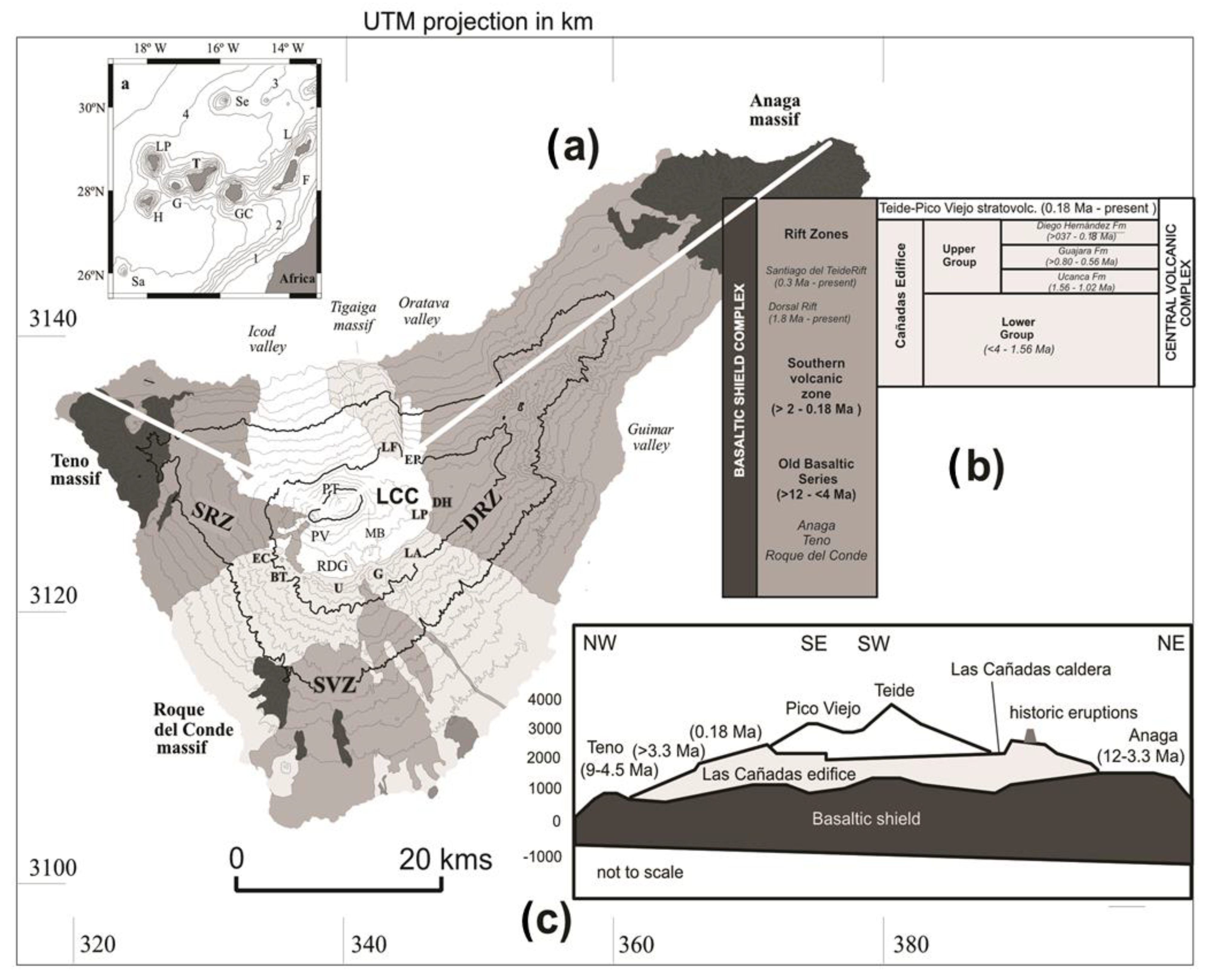
Table 1.
Relationship between Tenerife’s protected natural areas, their geological heritage, and their main geological hazards. The numbers in brackets are the locations shown in Figure 6 in red circles.
Table 1.
Relationship between Tenerife’s protected natural areas, their geological heritage, and their main geological hazards. The numbers in brackets are the locations shown in Figure 6 in red circles.
| Figure | Site | Geological Heritage | Geological Hazards Sensitivity |
|---|---|---|---|
| National parks | Teide (15) | Volcanism | Volcanic eruption |
| Strict nature reserves | Ijuana (16) | Erosion | Landslide |
| Pijaral (17) | No | No | |
| Los Roques de Anaga (18) | Erosion | No | |
| Pinoleris (19) | No | No | |
| Nature reserves | Malpaís de Güímar (20) | Lava flow | Volcanic eruption |
| Montaña Roja (21) | Volcanism/Erosion | Volcanic eruption | |
| Barranco del Infierno (22) | No | Mud Flows/Alluvial Fan | |
| Chinyero (23) | Volcanism | Volcanic eruption | |
| Las Palomas (24) | No | No | |
| Natural Parks | La Corona Forestal (25) | No | No |
| Rural Parks | Anaga (26) | Erosion/Old Volcanism | Landslide |
| Teno (27) | No | No | |
| Natural Monuments | Barranco de Fasnia y Güímar (28) | Erosion | Landslide |
| La Montaña Centinela (29) | Volcanism | Volcanic eruption | |
| Los Derriscaderos (30) | Volcanism | Volcanic eruption | |
| Las Montañas de Ifara y Los Riscos (31) | Volcanism | Volcanic eruption | |
| Montaña Pelada (32) | Volcanism | Volcanic eruption | |
| La Montaña Colorada (33) | No | No | |
| Roque de Jama (34) | Old Volcanism | No | |
| La Montaña Amarilla (35) | Volcanism | Volcanic eruption | |
| La Montaña de Guaza (36) | Volcanism | Volcanic eruption | |
| La Caldera del Rey (37) | Volcanism | Volcanic eruption | |
| La Montaña de Tejina (38) | No | No | |
| Teide (15) | Volcanism | Volcanic eruption | |
| Roque de Garachico (39) | Erosion | Landslide | |
| La Montaña de Los Frailes (40) | Volcanism | Volcanic eruption | |
| Protected Landscapes | La Rambla de Castro (41) | No | Mud Flows/Alluvial Fan |
| Las Lagunetas (42) | No | No | |
| Barranco de Erques (43) | Geomorphology | Mud Flows/Alluvial Fan | |
| Las Siete Lomas (44) | Volcanism | Volcanic eruption | |
| Ifonche (45) | No | No | |
| Los Acantilados de la Culata (46) | Geomorphology | Landslide | |
| La Resbala (47) | No | No | |
| Los Campeches, Tigaiga y Ruíz (48) | Geomorphology | Mud Flows/Alluvial Fan | |
| Costa de Acentejo (49) | Geomorphology | Landslide | |
| Sites of Scientific Interest | Acantilado de La Hondura (50) | Geomorphology | Landslide |
| Tabaibal del Porís (51) | No | No | |
| Los Acantilados de Isorana (52) | Geomorphology | Landslide | |
| La Caleta (53) | No | No | |
| Interián (54) | No | No | |
| Barranco de Ruiz (55) | No | No |
Disclaimer/Publisher’s Note: The statements, opinions and data contained in all publications are solely those of the individual author(s) and contributor(s) and not of MDPI and/or the editor(s). MDPI and/or the editor(s) disclaim responsibility for any injury to people or property resulting from any ideas, methods, instructions or products referred to in the content. |
© 2023 by the authors. Licensee MDPI, Basel, Switzerland. This article is an open access article distributed under the terms and conditions of the Creative Commons Attribution (CC BY) license (https://creativecommons.org/licenses/by/4.0/).
Share and Cite
MDPI and ACS Style
López-Saavedra, M.; Martí, J.; Planagumà, L. How Effective Risk Assessment and Management Is the Key to Turning Volcanic Islands into a Source of Nature-Based Solutions. Land 2023, 12, 686. https://doi.org/10.3390/land12030686
AMA Style
López-Saavedra M, Martí J, Planagumà L. How Effective Risk Assessment and Management Is the Key to Turning Volcanic Islands into a Source of Nature-Based Solutions. Land. 2023; 12(3):686. https://doi.org/10.3390/land12030686
Chicago/Turabian StyleLópez-Saavedra, Marta, Joan Martí, and Llorenç Planagumà. 2023. "How Effective Risk Assessment and Management Is the Key to Turning Volcanic Islands into a Source of Nature-Based Solutions" Land 12, no. 3: 686. https://doi.org/10.3390/land12030686
Note that from the first issue of 2016, this journal uses article numbers instead of page numbers. See further details here.