Mapping Urbanization Dynamics in Major Cities of Colombia, Ecuador, Perú, and Bolivia Using Night-Time Satellite Imagery

Abstract
:
1. Introduction
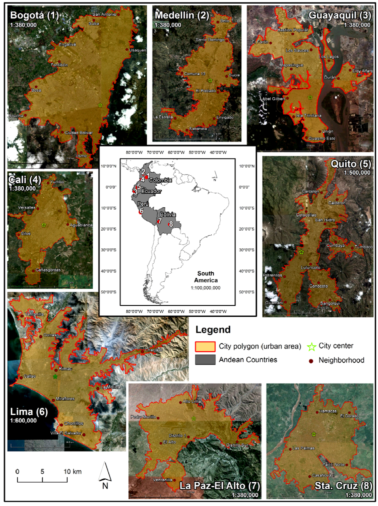
2. Study Area
2.1. Andean Region—Bolivia, Colombia, Ecuador, and Perú
2.2. City Profiles
2.2.1. Bogotá, Cali, and Medellín (Colombia)
2.2.2. Quito and Guayaquil (Ecuador)

2.2.3. Lima (Perú)
2.2.4. La Paz/El Alto and Santa Cruz de la Sierra (Bolivia)
3. Data and Methods
3.1. Demographic Data
3.2. Using Google Earth for Urban Mapping and for Collecting Land Cover Data
3.3. DMSP/OLS Night-Time Satellite Data
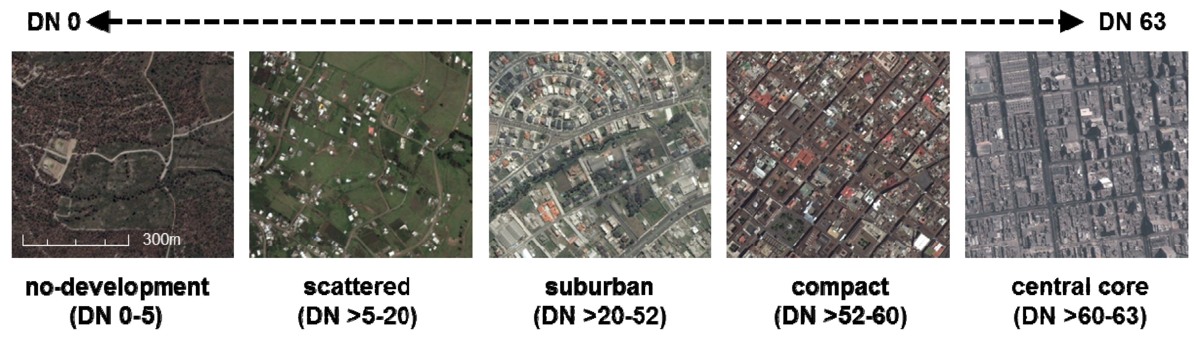
NTL Image Classification and Threshold Analysis

4. Results
4.1. Population Dynamics from 1992 to 2009 and Urban Extent of the Major Cities in the Andean Region

| Country | City | Urban Population in 1992 | Urban Population in 2009 | Annual Population Growth Rate 1992–2009 | Google Earth Image Year | Urban Area (extent) | Urban Population Density (per/km2) | Number of Munici-palities |
|---|---|---|---|---|---|---|---|---|
| Bolivia | La Paz/El Alto | 1,189,000 | 1,847,000 | 2.6 | 2009 | 200 km2 | 9,235 | 4 |
| Santa Cruz | 710,000 | 1,584,000 | 4.8 | 2009 | 221 km2 | 7,167 | 1 | |
| Colombia | Bogotá | 5,030,000 | 7,609,000 | 2.5 | 2009 | 364 km2 | 20,904 | 2 |
| Cali | 1,976,000 | 2,664,000 | 1.8 | 2007 | 132 km2 | 20,182 | 2 | |
| Medellín | 2,199,000 | 3,231,000 | 2.3 | 2008 | 151 km2 | 21,397 | 6 | |
| Ecuador | Guayaquil | 1,711,000 | 2,732,000 | 2.8 | 2009 | 209 km2 | 13,072 | 3 |
| Quito | 1,372,000 | 2,165,000 | 2.7 | 2008 | 331 km2 | 6,541 | 14 | |
| Perú | Lima | 6,106,000 | 8,462,000 | 1.9 | 2009 | 760 km2 | 11,134 | 38 |
| TOTAL | 20,292,000 | 30,294,000 | 2.4 | 70 |
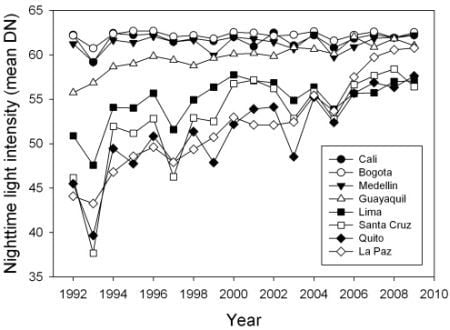
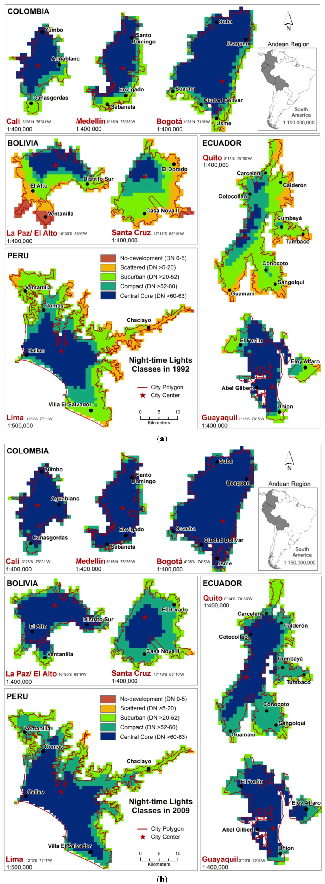
4.2. Urbanization Dynamics Based on Night-Time Lights Data
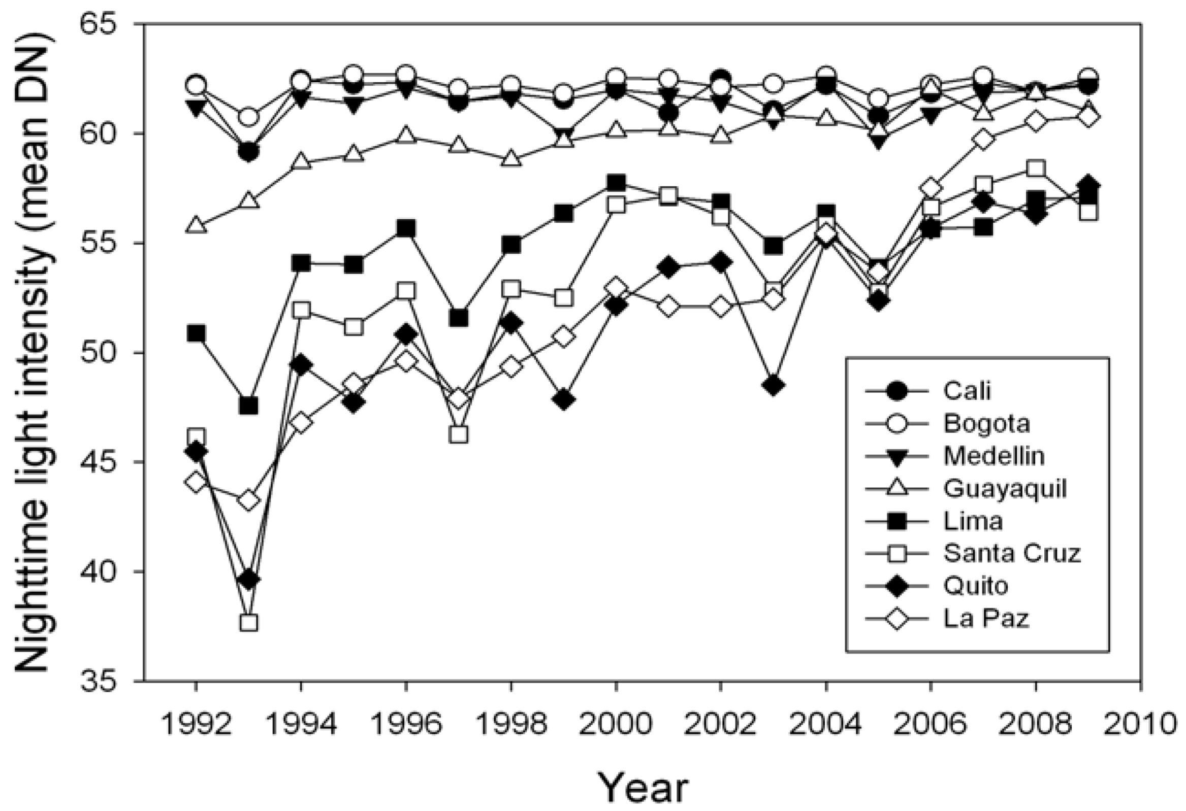
4.2.1. Level and Rate of Urbanization between 1992 and 2009
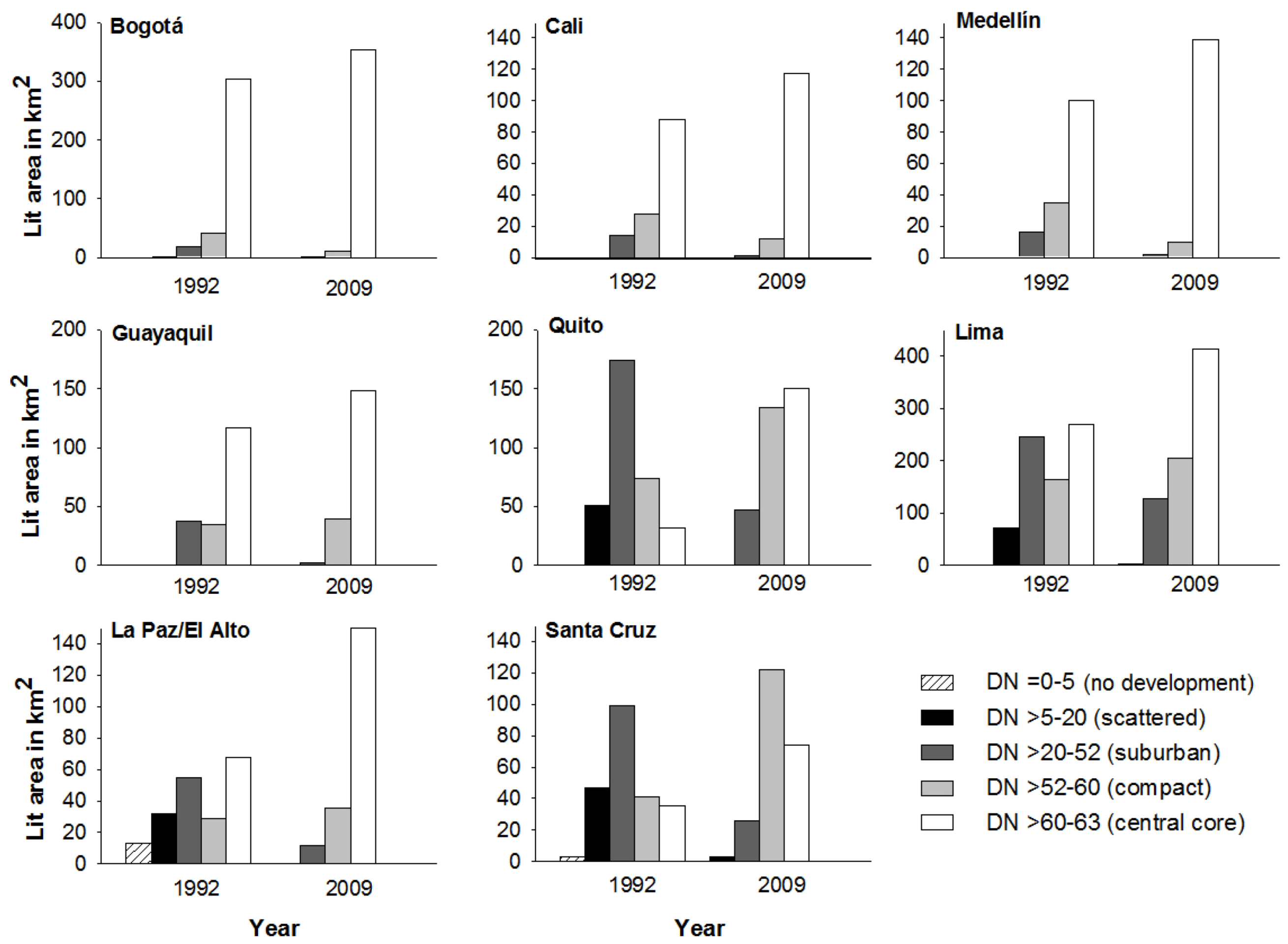
4.2.2. Changes in Area and in the Distribution of Urban Land-Use Classes


4.2.3. Dominant Patterns of Urban Development
5. Discussion
5.1. Utility of Google Earth and Night-Time Lights Data for Monitoring Urbanization Dynamics
5.2. Factors Shaping Urban Development in the Andean Region
5.2.1. Andean Geography
5.2.2. Land Value and Housing Prices
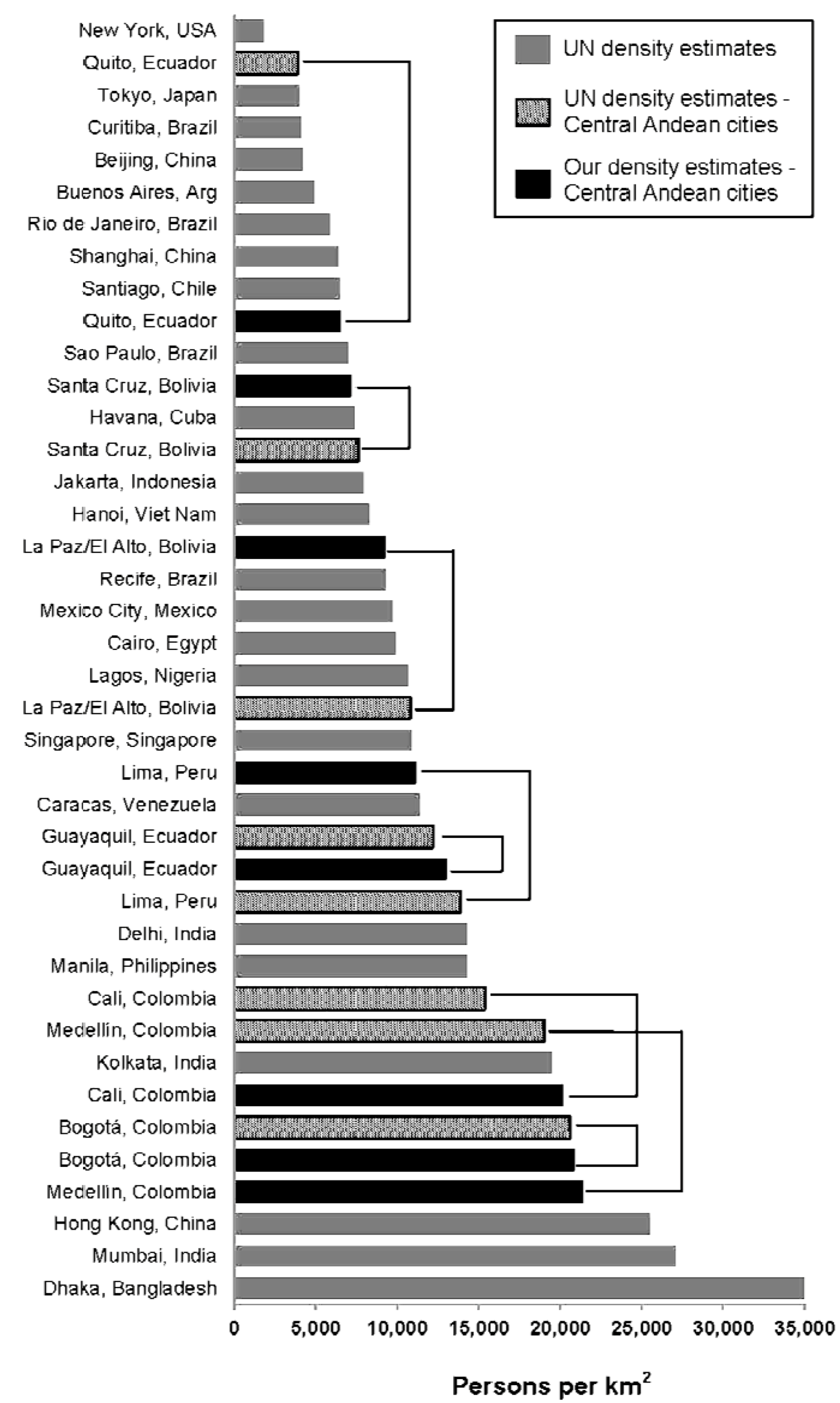
5.3. Urban Density Levels in the Andean Region, a Global Perspective

6. Conclusions
Acknowledgments
References
- OECD Environmental Outlook to 2050: The Consequences of Inaction; Organization for Economic Co-operation and Development: Paris, France, 2012; p. 350.
- World Urbanization Prospects: The 2011 Revision; Population Division, Department of Economic and Social Affairs, United Nations: New York, NY, USA, 2012; p. 302.
- Ziólkowski, J.A. Trends in Sociological Research in Urbanization in Europe. In Presented at the Seminar on Urban Development Policy and Planning, Warsaw, Poland, August 1962; p. 12.
- Angel, S.; Parent, J.; Civco, D.L.; Blei, A.M. Making Room for a Planet of Cities; Lincoln Institute of Land Policy: Cambridge, MA, USA, 2011; p. 76. [Google Scholar]
- Cadena, A.; Remes, J.; Manyika, J.; Dobbs, R.; Roxburgh, C.; Elstrodt, H.P.; Chaia, A.; Restrepo, A. Building Globally Competitive Cities: The Key to Latin American Growth; McKinsey Global Institute: San Francisco, CA, USA, 2011; p. 15. [Google Scholar]
- Seto, K.C.; Fragkias, M.; Güneralp, B.; Reilly, M.K. A meta-analysis of global urban land expansion. PloS one 2011, 6, e23777. [Google Scholar]
- Schneider, A.; Woodcock, C.E. Compact, dispersed, fragmented, extensive? A comparison of urban growth in twenty-five global cities using remotely sensed data, pattern metrics and census information. Urban Stud. 2008, 45, 659–692. [Google Scholar] [CrossRef]
- Bolay, J.C. What sustainable development for the cities of the South? Urban issues for a third millennium. Int. J. Urban Sustain. Dev. 2012, 4, 76–93. [Google Scholar] [CrossRef]
- State of the World’s Cities 2008/2009-Harmonious Cities; UN-Habitat: Nairobi, Kenya, 2008; p. 204.
- Geng, Y.; Peng, C.; Tian, M. Energy use and CO2 emission inventories in the four municipalities of China. Energy Procedia 2011, 5, 370–376. [Google Scholar] [CrossRef]
- UNW-DPAC. Water and Cities Facts and Figures. In Proceedings of Sustainable Water Management in Cities: Engaging Stakeholders for Effective Change and Action, Zaragoza, Spain, 13–17 December 2010; p. 4.
- Potsiou, C.; Doytsher, P.; Khouri, R.; McLaren, R.; Mueller, H. Rapid Urbanization and Mega Cities: The Need for Spatial Information Management. In Presented at the XXIV FIG International Congress, Sydney, Australia, 11–16 April 2010; p. 25.
- Davis, M. Planet of slums. Common Knowl. 2008, 14, 5–34. [Google Scholar]
- Fernandes, E. Regularization of Informal Settlements in Latin America; Lincoln Institute of Land Policy: Cambridge, MA, USA, 2011; p. 52. [Google Scholar]
- World Development Report 2011; Giralt, E.; Andrew, D. (Eds.) The World Bank Group: Washington, DC, USA, 2011; Volume 2011, p. 416.
- The Challenge of Slums: Global Report on Human Settlements 2003; UN-Habitat: Nairobi, Kenya, 2012; p. 344.
- Inostroza-Pino, L.; Baur, R.; Csaplovics, E.; Willet, B. Urban Sprawl and Fragmentation in Latin America: A Comparison with European Cities—The Myth of the Diffuse Latin American City; Lincoln Institute of Land Policy: Cambridge, MA, USA, 2010. [Google Scholar]
- Cohen, B. Urbanization in developing countries: Current trends, future projections, and key challenges for sustainability. Cities 2006, 28, 63–80. [Google Scholar]
- World Urbanization Prospects: The 2009 Revision—Highlights; Population Division, Department of Economic and Social Affairs, United Nations: New York, NY, USA, 2010; Volume 24, p. 47.
- Alvarez-Berríos, N.L.; Parés-Ramos, I.K.; Aide, T.M. Contrasting patterns of urban expansion in Colombia, Ecuador, Peru, and Bolivia Between 1992 and 2009. Ambio 2012, 42, 29–40. [Google Scholar]
- Skinner, R. City profile: Bogotá. Cities 2004, 21, 73–81. [Google Scholar] [CrossRef]
- Ortiz, A. Cali, Colombia: Toward a City Development Strategy; The World Bank Group: Washington, DC, USA, 2002; p. 112. [Google Scholar]
- Brand, P. Ecologism and urban space: Nature, urbanisation and city planning in Medellin, Colombia. Plann. Pract. Res. 1995, 10, 55–66. [Google Scholar] [CrossRef]
- Quito Environment and Climate Change Outlook (ECCO-Q); United Nations Environment Programme: Nairobi, Kenya, 2011; p. 192.
- Delgado, A. Guayaquil. J. Cities 2011. [Google Scholar] [CrossRef]
- Leonard, J. City profile: Lima. Cities 2000, 17, 433–445. [Google Scholar] [CrossRef]
- Arbona, J.M.; Kohl, B. City profile: La Paz-El Alto. Cities 2004, 21, 255–265. [Google Scholar] [CrossRef]
- Kirshner, J.D. City profile: Santa Cruz de la Sierra. Cities 2012. [Google Scholar] [CrossRef]
- Census of Population, Housing and Socio-Demographic Indicators; Instituto Nacional de Estadística (INE): Bolivia, 2011.
- Census of Population; Departamento Administrativo Nacional de Estadística (DANE): Colombia, 2011.
- Census of Population and Housing; Instituto Nacional de Estadística y Censos (INEC): Ecuador, 2011.
- Census of Population and Housing; Instituto Nacional de Estadística e Informática (INEI): Perú, 2011.
- Clark, M.L.; Aide, T.M. Virtual Interpretation of Earth Web-Interface Tool (VIEW-IT) for collecting land-use/land-cover reference data. Remote Sens. 2011, 3, 601–620. [Google Scholar] [CrossRef]
- Fritz, S.; See, L.; McCallum, I.; Schill, C.; Perger, C.; Obersteiner, M. Building a Crowd-Sourcing Tool for the Validation of Urban Extent and Gridded Population. In Computational Science and Its Applications ICCSA 2011; Murgante, B., Gervasi, O., Iglesias, A., Taniar, D., Apduhan, B., Eds.; Springer: Berlin/Heidelberg, German, 2011; Volume 6783, pp. 39–50. [Google Scholar]
- Dorais, A.; Cardille, J. Strategies for incorporating high-resolution google earth databases to guide and validate classifications: Understanding deforestation in Borneo. Remote Sens. 2011, 3, 1157–1176. [Google Scholar] [CrossRef]
- Doll, C.N.H. CIESIN Thematic Guide to Night-Time Light Remote Sensing and its Applications; Center for International Earth Science Information Network (CIESIN), Columbia University: Palisades, NY, USA, 2008; pp. 1–41. [Google Scholar]
- Welch, R. Monitoring urban population and energy utilization patterns from satellite data. Remote Sens. Environ. 1980, 9, 1–9. [Google Scholar] [CrossRef]
- Amaral, S.; Camara, G.; Monteiro, A.; Quintanilha, J.; Elvidge, C. Estimating population and energy consumption in Brazilian Amazonia using DMSP night-time satellite data. Comput. Environ. Urban Syst. 2005, 29, 179–195. [Google Scholar] [CrossRef]
- Sutton, P.; Roberts, D.; Elvidge, C.; Melj, H. A comparison of nighttime satellite imagery and population density for the continental United States. Society 1997, 63, 1303–1313. [Google Scholar]
- Sutton, P.; Roberts, D.; Elvidge, C.; Baugh, K. Census from heaven: An estimate of the global human population using night-time satellite imagery. Int. J. Remote Sens. 2001, 22, 3061–3076. [Google Scholar]
- Zhang, Q.; Seto, K.C. Mapping urbanization dynamics at regional and global scales using multi-temporal DMSP/OLS nighttime light data. Remote Sens. Environ. 2011, 115, 2320–2329. [Google Scholar] [CrossRef]
- Lo, C.P. Urban indicators of China from radiance-calibrated digital DMSP-OLS nighttime images. Ann. Assoc. Am. Geogr. 2002, 92, 225–240. [Google Scholar]
- Elvidge, C.D.; Baugh, K.E.; Kihn, E.A.; Kroehl, H.W.; Davis, E.R.; Davis, C.W. Relation between satellite observed visible-near infrared emissions, population, economic activity and electric power consumption. Int. J. Remote Sens. 1997, 18, 1373–1379. [Google Scholar]
- Ghosh, T.; Sutton, P.; Powell, R.; Anderson, S.; Elvidge, C.D. Estimation of Mexico’s Informal Economy Using DMSP Nighttime Lights Data. In Proceedings of the Joint Urban Remote Sensing Event 2009, Shanghai, China, 20–22 May 2009; pp. 1–10.
- Sutton, P.C.; Costanza, R. Global estimates of market and non-market values derived from nighttime satellite imagery, land cover, and ecosystem service valuation. Ecol. Econ. 2002, 41, 509–527. [Google Scholar] [CrossRef]
- Muller, J.; Elvidge, C.D. Night-time imagery as a tool for global mapping of socioeconomic parameters and greenhouse gas emissions. Ambio 2000, 29, 157–162. [Google Scholar]
- Liu, Q.; Sutton, P.C.; Elvidge, C.D. Relationships between Nighttime Imagery and Population Density for Hong Kong. In Proceedings of the 31st Asia-Pacific Advanced Network Meetings, Hong Kong, China, 21–25 January 2011; Volume 31, pp. 80–91.
- Sutton, P. Modeling population density with night-time satellite imagery and GIS. Comput. Environ. Urban Syst. 1997, 21, 227–244. [Google Scholar] [CrossRef]
- Elvidge, C.D.; Baugh, K.E.; Anderson, S.J.; Sutton, P.C.; Ghosh, T. The Night Light Development Index (NLDI): A spatially explicit measure of human development from satellite data. Soc. Geogr. 2012, 7, 23–35. [Google Scholar] [CrossRef]
- Liu, Z.; He, C.; Yang, Y. Mapping Urban Areas by Performing Systematic Correction for DMSP/OLS Nighttime Lights Time Series in China from 1992 to 2008. In Proceedings of 2011 IEEE International Conference on GeoScience and Remote Sensing Symposium (IGARSS), Vancouver, BC, Canada, 24–29 July 2011; pp. 1858–1861.
- Ma, T.; Zhou, C.; Pei, T.; Haynie, S.; Fan, J. Quantitative estimation of urbanization dynamics using time series of DMSP/OLS nighttime light data: A comparative case study from China’s cities. Remote Sens. Environ. 2012, 124, 99–107. [Google Scholar] [CrossRef]
- Sutton, P.; Goetz, A.; Fildes, S.; Forster, C.; Ghosh, T. Darkness on the edge of town: Mapping urban and peri-urban Australia using nighttime satellite imagery. Prof. Geogr. 2010, 62, 119–133. [Google Scholar] [CrossRef]
- United Nations. CEPALSTATS. Indicadores Sociales Vivienda Hogares con disponibilidad de servicios básicos en la vivienda, por área urbana y rural. Available online: http://websie.eclac.cl (accessed on 1 July 2012).
- Galster, G.; Hanson, R.; Ratcliffe, M.R.; Wolman, H.; Coleman, S.; Freihage, J. Wrestling sprawl to the ground: Defining and measuring an elusive concept. Housing Policy Debate 2001, 12, 681–717. [Google Scholar] [CrossRef]
- Herold, M.; Roberts, D.A. The Spectral Dimension in Urban Remote Sensing. In Remote Sensing of Urban and Suburban Areas; Juergens, C., Rashed, T., Eds.; Springer: London, UK, 2008; p. 300. [Google Scholar]
- Rojas, N. The art of development images promoting dialogue and alternatives to poverty and violence in local communities of Colombia. Consilience 2011, 5, 190–200. [Google Scholar]
- Salazar Ferro, J. Bogotá’s Recovery Process. In Megacities Urban Form, Governance, and Sustainability; Sorensen, A., Okata, J., Eds.; Springer: New York, NY, USA, 2010; p. 262. [Google Scholar]
- Rueda-García, N. Urban Slums Reports: The Case of Bogotá, Colombia. In Understanding Slums: Case Studies for the Global Report; United Nations Human Settlements Programme: Nairobi, Kenya; Development Planning Unit, University College London: London, UK, 2003; p. 32. [Google Scholar]
- Ballesteros, J.E.; Velásquez, C.; Sierra, M.; Torre, E.; Vélez, E. Santo Domingo Savio: un territorio reterritorializado (in Spanish). Territorios 2010, 22, 87–110. [Google Scholar]
- Gaviria-Gutiérrez, Z. La expansión urbana sobre las periferias rurales del entorno inmediato a la ciudad metropolitan (in Spanish). Revista Soluciones de Postgrado EIA 2009, 3, 63–74. [Google Scholar]
- Vargas, C.S.J. Displaced people in Bogotá and Soacha: Characteristics and protection. Revista de Paz y Conflictos 2011, 4, 102–120. [Google Scholar]
- Davila, J. Urban Poverty Reduction Experiences in Cali, Colombia: Lessons from the Work of Non-profit Organisations; Human Settlements Working Paper Series Poverty Reduction in Urban Areas No. 4; International Institute for Environment and Development: London, UK, 2002. [Google Scholar]
- Riofrío, G. Urban Slums Reports: The Case of Lima, Peru. In Understanding Slums: Case Studies for the Global Report; United Nations Human Settlements Programme: Nairobi, Kenya; Development Planning Unit, University College London: London, UK, 2003; p. 15. [Google Scholar]
- Imparato, I.; Ruster, J. Slum Upgrading and Participation: Lessons from Latin America; The World Bank Group: Washington, DC, USA, 2003; p. 489. [Google Scholar]
- Bontenbal, M.; Van Lindert, P. Bridging local institutions and civil society in Latin America: can city-to-city cooperation make a difference? Environ. Urban. 2008, 20, 465–481. [Google Scholar] [CrossRef]
- Iriarte, G. Análisis crítico de la realidad, 17th ed; Editorial Quipus: Cochabamba, Bolivia, 2007; p. 698. [Google Scholar]
- Prado Salmón, F. Perfil ambiental de Santa Cruz de la Sierra; Institute for Housing and Urban Development Studies (HIS),Erasmus University: Rotterdam, The Netherlands, 2000; p. 49. [Google Scholar]
- Hernani-Limarino, W.L.; Jimenez, W.; Arias, B.; Larrea, C. Research Proposal: The Quality of Life of Urban Neighborhoods in Bolivia: A Case of Study of the Great La Paz and Santa Cruz. Available online: www.iadb.org/res/laresnetwork/files/pr302finaldraft.pdf (accessed on 2 November 2012).
- Dureau, F.; Barbary, O.; Gouëset, V.; Pissoa, O.; Dureau, T. Ciudades y sociedades en mutación Lecturas cruzadas sobre Colombia, 1st ed; Bogotá Universidad Externado de Colombia: Bogotá, Colombia, 2007; Volume 1, p. 470. [Google Scholar]
- Madrid, G.; Lovell, T. Working with flowers in Colombia: the “lucky chance”? Work 2007, 30, 217–227. [Google Scholar]
- Bocarejo, J.P.; Portilla, I.; Pérez, M.A. Impact of Transmilenio on density, land use, and land value in Bogot. Res. Transport. Econ. 2013, 40, 78–86. [Google Scholar]
- Wessels, G.; Pardo, C.F.; Bocarejo, J.P. Report. Bogota 21: Toward a World-Class Transit-Oriented Metropolis; Bogotá, Colombia, 2012; p. 105. [Google Scholar]
- Rustiadi, E.; Panuju, D.R. Spatial Pattern of Suburbanization and Land-Use Change Process: Case Study in Jakarta Suburb. In Land-Use Changes in Comparative Perspective; Himiyama, Y., Hwang, M., Ichinose, T., Eds.; Enfield Publishing & Distribution Co.: Enfield, NH, USA; p. 262.
- Gilbert, A. Employment and poverty during economic restructuring: The case of Bogotá, Colombia. Urban Studies 1997, 34, 1047–1070. [Google Scholar] [CrossRef]
- Sutton, P. A scale-adjusted measure of “urban sprawl” using nighttime satellite imagery. Remote Sens. Environ. 2003, 86, 353–369. [Google Scholar] [CrossRef]
- Kearns, A.; Paddison, R. New challenges for urban governance. Urban Studies 2000, 37, 845–850. [Google Scholar] [CrossRef]
© 2013 by the authors; licensee MDPI, Basel, Switzerland. This article is an open access article distributed under the terms and conditions of the Creative Commons Attribution license (http://creativecommons.org/licenses/by/3.0/).
Share and Cite
Parés-Ramos, I.K.; Álvarez-Berríos, N.L.; Aide, T.M. Mapping Urbanization Dynamics in Major Cities of Colombia, Ecuador, Perú, and Bolivia Using Night-Time Satellite Imagery. Land 2013, 2, 37-59. https://doi.org/10.3390/land2010037
Parés-Ramos IK, Álvarez-Berríos NL, Aide TM. Mapping Urbanization Dynamics in Major Cities of Colombia, Ecuador, Perú, and Bolivia Using Night-Time Satellite Imagery. Land. 2013; 2(1):37-59. https://doi.org/10.3390/land2010037
Chicago/Turabian StyleParés-Ramos, Isabel K., Nora L. Álvarez-Berríos, and T. Mitchell Aide. 2013. "Mapping Urbanization Dynamics in Major Cities of Colombia, Ecuador, Perú, and Bolivia Using Night-Time Satellite Imagery" Land 2, no. 1: 37-59. https://doi.org/10.3390/land2010037
APA StyleParés-Ramos, I. K., Álvarez-Berríos, N. L., & Aide, T. M. (2013). Mapping Urbanization Dynamics in Major Cities of Colombia, Ecuador, Perú, and Bolivia Using Night-Time Satellite Imagery. Land, 2(1), 37-59. https://doi.org/10.3390/land2010037