Article

Cooperative Exploration Model of Coal–Gallium Deposit: A Case Study of the Heidaigou Coal–Gallium Deposit in the Jungar Coalfield, Inner Mongolia, China

1
College of Geoscience and Surveying Engineering, China University of Mining and Technology, Beijing 100083, China
2
State Key Laboratory for Fine Exploration and Intelligent Development of Coal Resources, China University of Mining and Technology, Beijing 100083, China
*
Author to whom correspondence should be addressed.
Minerals 2024, 14(2), 156; https://doi.org/10.3390/min14020156
Submission received: 26 December 2023 / Revised: 23 January 2024 / Accepted: 30 January 2024 / Published: 31 January 2024

Abstract

:
Gallium (Ga) is a typical scattered trace element that is irreplaceable in strategic sectors such as national defense, wireless communications, new materials, renewable energy, and healthcare. The coal–Ga deposit is an important complement to traditional Ga resources and has become a significant focus for Ga mineral resource exploration. Therefore, there is an urgent need to research the coal–Ga cooperative exploration model from both technical and economic perspectives. Taking the Heidaigou coal–Ga deposit as an example, the enrichment zone of coal–Ga is predominantly situated in the northern part of the exploration area, adjacent to the fault zone. The Ga concentration demonstrates a gradual decline from the north–central region towards the northeast and southeast. Similar vertical Ga distribution patterns are observed in adjacent drillings, with notably higher concentrations in the roof, floor, and parting layers. The cooperative exploration model for coal–Ga deposits is proposed based on the above features. The model employs a comprehensive set of cooperative technical methods, such as remote sensing, geological mapping, seismic exploration, drilling, petrogeochemistry, and well logging. The layout of exploration engineering and the concentration of Ga provide the basis for the estimation of Ga resources. Additionally, the model provides an important scientific basis for the improvement of the strategic coordination ability of Ga mineral resources.

Graphical Abstract

1. Introduction

Gallium (Ga) is a typical scattered trace element, often termed the “food of the electronics industry” due to its widespread use in strategic sectors such as national defense, wireless communications, new materials, renewable energy, and healthcare [1,2,3,4,5,6,7]. The assurance of the Ga supply and the continual advancement of Ga-based technologies are vital for the progress of the modern science and technology industry. Presently, dedicated Ga mines are non-existent, and Ga production relies on the availability of bauxite [8,9]; thus, the search for new Ga resources has become a priority. Coal, as a unique sedimentary deposit, not only serves as fuel but also harbors coal-type strategic metal deposits [10,11,12]. The 2006 discovery of an exceptionally large Ga-enriched coal deposit in the Inner Mongolia Jungar Coalfield has illuminated the metallogeny of dispersed elements, such as Ga, positioning the study of coal–Ga resources at the forefront of research [13,14,15,16,17,18,19,20,21,22,23,24,25,26,27,28,29]. This has led to the identification of several coal–Ga deposits ranging from medium to super-large sizes, and the Ga resource ranges from 400 to over 2000 t [30,31,32]. The cut-off grade of Ga in coal is 20 μg/g [33], and the industrial grade is 50 μg/g [34]. As a crucial supplement to traditional strategic metal resources, coal–Ga deposits have emerged as a significant focus in mineral resource exploration. Investigating the joint exploration of coal and Ga is therefore essential in ensuring a steady Ga supply and fostering the growth of a sustainable, circular economy.
The mode of occurrence of Ga in coal either has an organically dominant or an inorganically dominant association [35,36,37,38,39]. Inorganic forms of the specified element or compound are primarily found in clay minerals and bauxite, due to the isomorphic substitution of aluminum [12,16,40,41,42,43]. The organic state mainly occurs in the form of humic acid adsorption and gelatinous components, etc. [44,45,46]. However, more studies have shown an inorganic dominant association of Ga in coal [47,48,49]. Ga and its associated mineral boehmite, found in the coal of the Heidaigou Mine within the Jungar Coalfield, are of sedimentary origin [13,14], derived from the weathered bauxite of the Benxi Formation in the northeast uplift of the Ordos Basin [43,44]. During the peat accumulation phase, gibbsite colloids from this weathered bauxite were transported a short distance to the peat bog. There, they transformed into boehmite throμgh processes like compaction, dehydration, and coalescence during the early diagenesis stages [13,14].
The exploration and development of strategic metal elements dispersed in coal and coal-bearing strata, which symbiotically coexist with coal, present complexities when they are treated as separate deposits. Consequently, a cooperative exploration approach for coal and strategic metal deposits within coal-bearing strata needs to be theoretically sound, economically viable, and technically feasible. In coalfield exploration, the exploration model that combines geological condition identification with exploration technology methods and project layout planning has provided valuable insights for similar projects [50,51]. In recent years, the cooperative exploration of coal-measure minerals has typically built upon the proposed mechanisms of mineralization and prospecting prediction methods for coal-measure minerals [52,53]. This approach has led to the formulation of fundamental principles for cooperative exploration [54,55,56], the categorization of exploration types based on the combination of coal-measure mineral varieties and corresponding exploration techniques [57,58], and the development of a cooperative exploration system for coal-measure minerals with multi-positional resource characteristics, along with its implementation plans [59,60,61,62,63].
Currently, there is a lack of research on the cooperative exploration model for coal–Ga deposits. This study focuses on the Heidaigou coal–Ga deposit, examining its distribution characteristics and enrichment mechanisms, and discusses and optimizes the original exploration. On this basis, a cooperative exploration model for coal–Ga deposits is proposed. This model is grounded in disciplines such as coal geology, geochemistry, and mineralogy, as well as exploration engineering. It incorporates an integrated approach involving remote sensing, geological mapping, drilling, well logging, seismic surveys, and petrogeochemistry. Adhering to the standards for single mineral exploration and other relevant guidelines, this research delineates the goals and objectives of coal–Ga deposit exploration. It also establishes criteria for the assessment of the grade, occurrence, and quantity of coal–Ga resources. In different coal–Ga deposits, the occurrence of Ga is similar, primarily associated with clay minerals such as boehmite, diaspore, and kaolinite. The differences among these coal–Ga deposits arise from the unique characteristics of each coal deposit. Depending on these differences, the selection of exploration techniques, project layouts, and resource estimation methods can be guided by the coal–Ga cooperative exploration model proposed in this study, specifically the part concerning coal deposits. Therefore, the coal–Ga cooperative exploration model introduced in this study is feasible across different coal–Ga deposits.

2. Geological Background and Methodology

2.1. Jungar Coalfield

The Jungar Coalfield is located in the southwestern part of the Ordos Coal Gathering Basin (Figure 1), which is a significant Late Carboniferous–Permian coalfield, characterized by coal-bearing strata from the Shanxi and Taiyuan Formations. These formations represent a transitional phase of terrestrial sedimentation. The coalfield stretches approximately 73 km from north to south and around 40 km from east to west, covering an area of 2900 km2 [20]. Geotectonically situated on the eastern edge of the Ordos Plateau within the North China Craton, the Jungar Coalfield predominantly features a monoclinal structure. This structure is oriented almost north–south, inclining westward with a dip angle of less than 10°. Additionally, this monocline features small, undulating fold structures. Faults in the region are infrequent and minor in scale, predominantly normal faults [13].

2.2. Heidaigou Coal–Ga Deposit

The Heidaigou coal–Ga deposit is situated in the east–central part of the Jungar Coalfield, which is largely covered by loess, but some bedrocks are exposed in the valleys. The most ancient strata exposed in the coalfield are the Lower Ordovician Liangjiashan Formation (O1l), which constitutes the foundational layer of the coal-bearing strata. Successively overlying it are the Late Paleozoic coal-bearing strata comprising the Upper Carboniferous Benxi Formation (C2b), the Taiyuan Formation (C3t), and the Lower Permian Shanxi Formation (P1s). The sequence continues with the Middle Permian formations of the Lower Shihezi (P1x) and Upper Shihezi (P2s), followed by the Neogene Upper Pliocene red clay layer (N2), the Quaternary Upper Pleistocene Malan Formation (Q3), and the Quaternary Holocene (Q4) [20]. The extractable coal seams in the area include Coal Seams 5 and 6, totaling two layers. Coal Seam 5 is the main extractable seam, while Coal Seam 6 is extractable throμghout the area and is divided into coal seams 6-1, 6-2, 6-3, 6-4, 6-5, and 6-6 based on the coal quality characteristics and structure. The structural morphology of the Heidaigou mining area is mainly controlled by the Jiaogeibu anticline located in the eastern part of the area. Most of the region belongs to the western wing of this anticline, which trends northeast and inclines southeast. The stratum has a gentle dip angle, with the overall stratum trending NE40°–55°, inclining southeast, and the dip angle is generally less than 10°. There are few faults in the area, with only a few small faults developed in the central–northern part [14,15]. Overall, the structure of the entire area is quite regular, with both the fold axes and faults trending northeast. The fold axes incline from northeast to southwest, and the general structural situation of the bedrock in the exploration area is higher in the northeast and lower in the southwest. This pattern seems to control the regular variation of the strata and coal seams from northeast to southwest. The main coal-bearing formation, the Taiyuan Formation, tends to thicken gradually from northeast to southwest. The main structural diagram of the Heidaigou coal mining area is shown in Figure 1.

2.3. Methodology

A comprehensive analysis of borehole data and coal rock test data from the original exploration was conducted. This study focuses on the following factors influencing the coal–Ga deposits: the planar distribution of coal seams and the planar distribution characteristics of the Ga concentration and the vertical variations in the coal seam thickness and Ga concentration, referenced to the original geological report on the exploration of the Heidaigou mining area, Jungar Coalfield, Inner Mongolia [64]. The contour maps were created using Golden Software’s Surfer software (version 8.0). Referring to the Specifications for Coal Exploration [65] and Specifications for Rare Metal Mineral Exploration [66], an evaluation of the combination of exploration techniques and the layout of exploration projects from the original exploration was conducted, followed by proposed optimizations. Based on the Guidance for Utilization and Classification of Concentration of Valuable Elements in Coal [33], an estimate of the resource quantity for each coal layer in the exploration area was obtained. The content of Ga in this study refers to the content of coal drying basic [66]. From this work, a cooperative exploration model for coal–Ga is proposed.

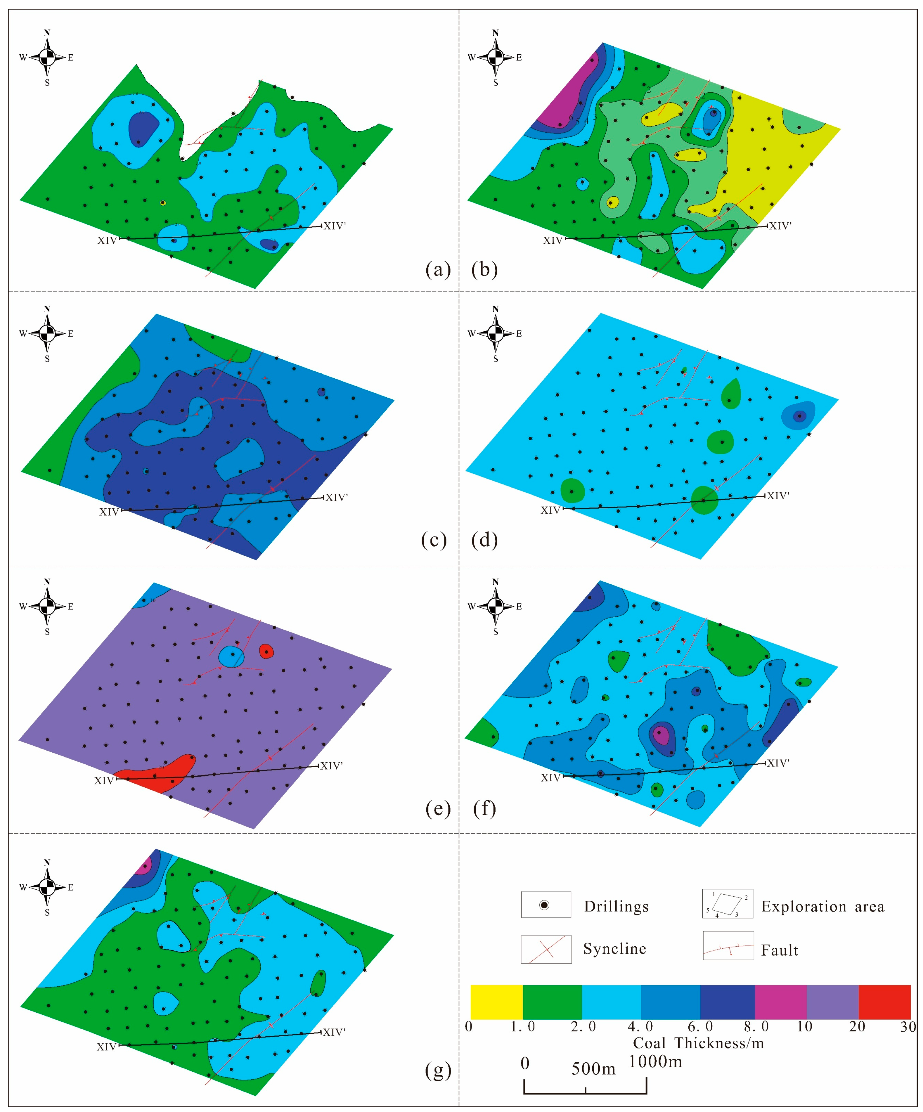
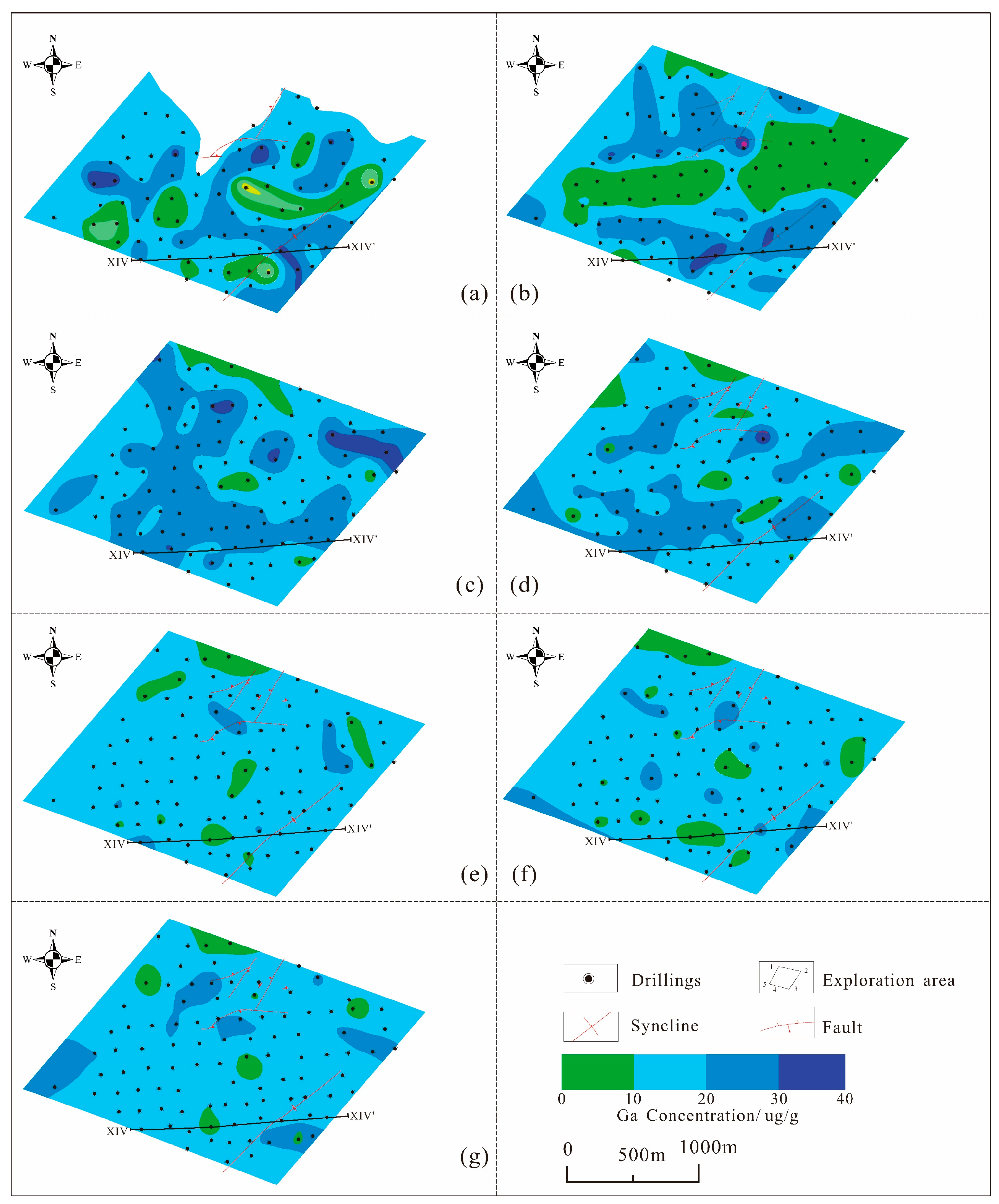
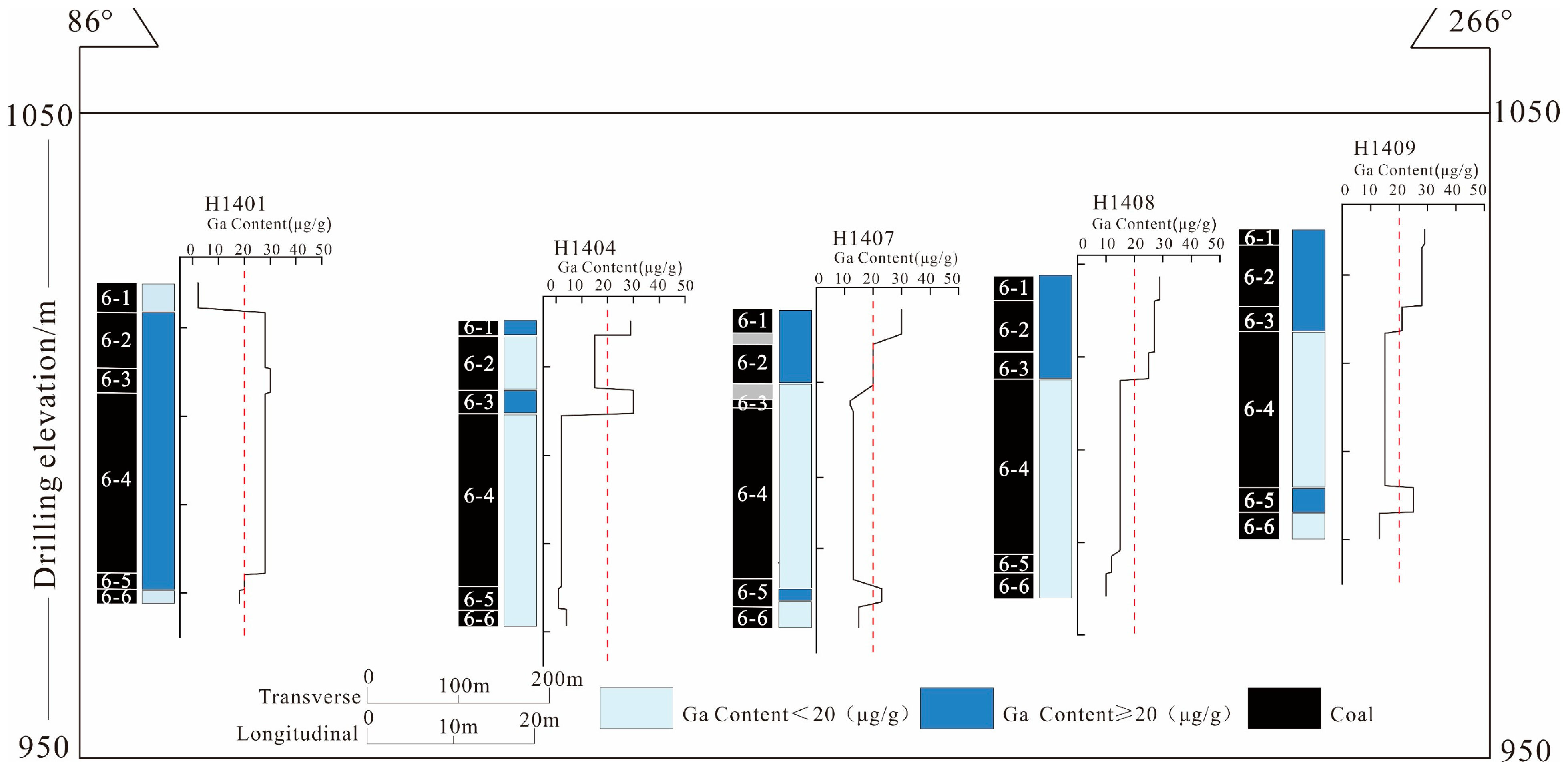
3. Distribution Characteristics of Coal–Ga Deposits

3.1. Plane of Coal Seams

The Heidaigou coal–Ga deposit is part of the Late Carboniferous–Early Permian coalfield, characterized by the coal-bearing strata of the Shanxi and Taiyuan Formations, which represent a transition to terrestrial sediments (Figure 2).
In the Shanxi Formation, coal seam 5, extractable and situated in the middle to lower part, varies in thickness from 0 to 4.27 m, averaging 1.59 m. This seam extends primarily across the southeast, southwest, and central areas of the exploration zone, encompassing a mineable area of 5.61 km2 and offering broad extractability across the region. In the Taiyuan Formation, the mineable coal seam 6, a composite coal seam, resides in the upper part, with a thickness ranging from 24.12 to 39.32 m and an average of 33.07 m. It is subdivided into six seams, 6-1, 6-2, 6-3, 6-4, 6-5, and 6-6, differentiated by their coal quality and structure. The uppermost coal seam 6-1 varies from 0 to 6.01 m in thickness, averaging 2.28 m. Sub-seam 6-2, known for its high ash concentration, ranges from 1.83 to 8.84 m thick, averaging 5.53 m. Notably, coal seam 6-2 exhibits a complex stratified structure, comprising extremely thin layers of inferior coal, high-ash coal, carbonaceous mudstone, or carbon-bearing mudstone interbedded vertically. Coal seam 6-3, with a thickness of 1.26 to 3.92 m, averaging 2.62 m, has a simple structure without intercalated gangue. Coal seam 6-4, ranging from 9.63 to 23.29 m thick and averaging 18.24 m, demonstrates a thickening trend from north to south and from west to east. Finally, coal seam 6-5’s thickness varies from 0.20 to 4.42 m, averaging 1.56 m, and it shows a thickening trend from south to north and from east to west.

3.2. Plane of Ga Deposit

The Ga concentration in each coal seam is notably high, as indicated in Figure 3. Within the exploration area, coal seam 5 varies in thickness from 0 to 4.27 m, averaging 1.59 m. The Ga concentration ranges from 1 to 28 μg/g, with an average of 22.47 μg/g. There is a discernible directional variation in Ga concentration, with higher concentrations observed in the northwest and southeast regions of the mining area, and lower concentrations in the southwest and northeast regions.
In the exploration area, the Ga concentrations within the 6-1 coal seam vary from 1 to 41 μg/g, averaging 19.02 μg/g, with higher concentrations in the northern and southern regions and lower levels in the central area. In the 6-2 seam, the Ga concentrations range from 0 to 36 μg/g, averaging 23.89 μg/g, predominantly higher in the eastern region but lower in the northern and central regions. The 6-3 seam exhibits Ga levels from 1 to 31 μg/g, with an average of 19.08 μg/g, and shows lower concentrations in the northeastern and northwestern areas. The Ga concentration in the 6-4 seam ranges from 1 to 28 μg/g, averaging 15.05 μg/g, with reduced levels in the northern, eastern, and central parts. The 6-5 seam’s Ga concentration, varying from 1 to 28 μg/g and averaging 17.63 μg/g, is higher in the western part and lower in the northern, central, and southwestern sections. The 6-6 seam, with Ga levels between 1 and 28 μg/g and an average of 15.49 μg/g, exhibits higher concentrations in the western and eastern regions and lower in the northern, central, and southwestern parts. After averaging the Ga concentration across all coal seams by thickness, the overall planar distribution trend of the coal–Ga deposit in the Heidaigou exploration area becomes apparent. Enrichment points are concentrated near the developed faults in the northern boreholes of the exploration area. The overall trend indicates a gradual decrease from the north–central area towards the northeast and southeast. Ga is enriched in the upper and lower layers of the coal seam. In the coal seams, partings are composed of non-mineral rocks located between ore bodies. However, the Ga concentration in some of these partings reaches 50 μg/g, which is the industrial grade for Ga in coal [34]. Since Ga in partings is primarily found in clay minerals [12,40,41,42,43], consistent with the inorganic state of Ga in coal, the Ga in partings represents a reservable resource for extraction and is a potential mineral resource.

3.3. Vertical Direction of Coal–Ga Deposit

The structural complexity of the No. 6 coal seam is relatively simple, with minimal variations in coal lithology and quality. A statistical analysis was conducted on the thickness of the coal and Ga concentration within the six coal seams across 98 boreholes to assess vertical variations.
Vertically, coal seam No. 6 features a high number of coal-bearing layers, with significant variations in thickness and stability among these layers. The structure of thick coal layers is complex, and coal seam No. 6 contains as many as 16 layers of intercalated gangue. The bifurcation phenomenon in these thick coal layers is also notable. Frequently, massive sandbodies are sandwiched in the middle, resulting in the reduced thickness of the coal layers. The thin coal layers exhibit poor stability and have a limited developmental range. The samples reach 50 μg/g, which is the industrial grade for Ga in coal that may be found in any of the coal seams 6-1, 6-2, 6-3, 6-4, 6-5, or 6-6 in the exploration area [34], but adjacent boreholes on the same exploration line show similar distribution characteristics. Taking the east–west direction of exploration line XIV as an example (Figure 4), the Ga concentration in drills 1404 and 1407 that have reached the industrial grade is concentrated in seams 6-1-6-3, and the rest of the drills within the line also have similar characteristics. These similar enrichment characteristics suggest that the formation of the coal-associated Ga deposit in the Heidaigou mining area may be related to the convergence of terrigenous materials during the peat accumulation period in the coal-forming basin, which is consistent with previous studies indicating that the Heidaigou coal-associated Ga deposit has a sedimentary origin [13,20,43]. The concentration of Ga in the coals of 6-1, 6-5, and 6-6 in some of the drills reaches the industrial utilization grade, and the enriched layers are close to the top and bottom plates of the coal seams; moreover, the concentration of Ga in the roof, floor, and parting in the drills is higher, and parts of them reach the industrial utilization grade of Ga, which indicates that epigenetic leaching and the action of groundwater may be related to the enrichment of Ga in coal.

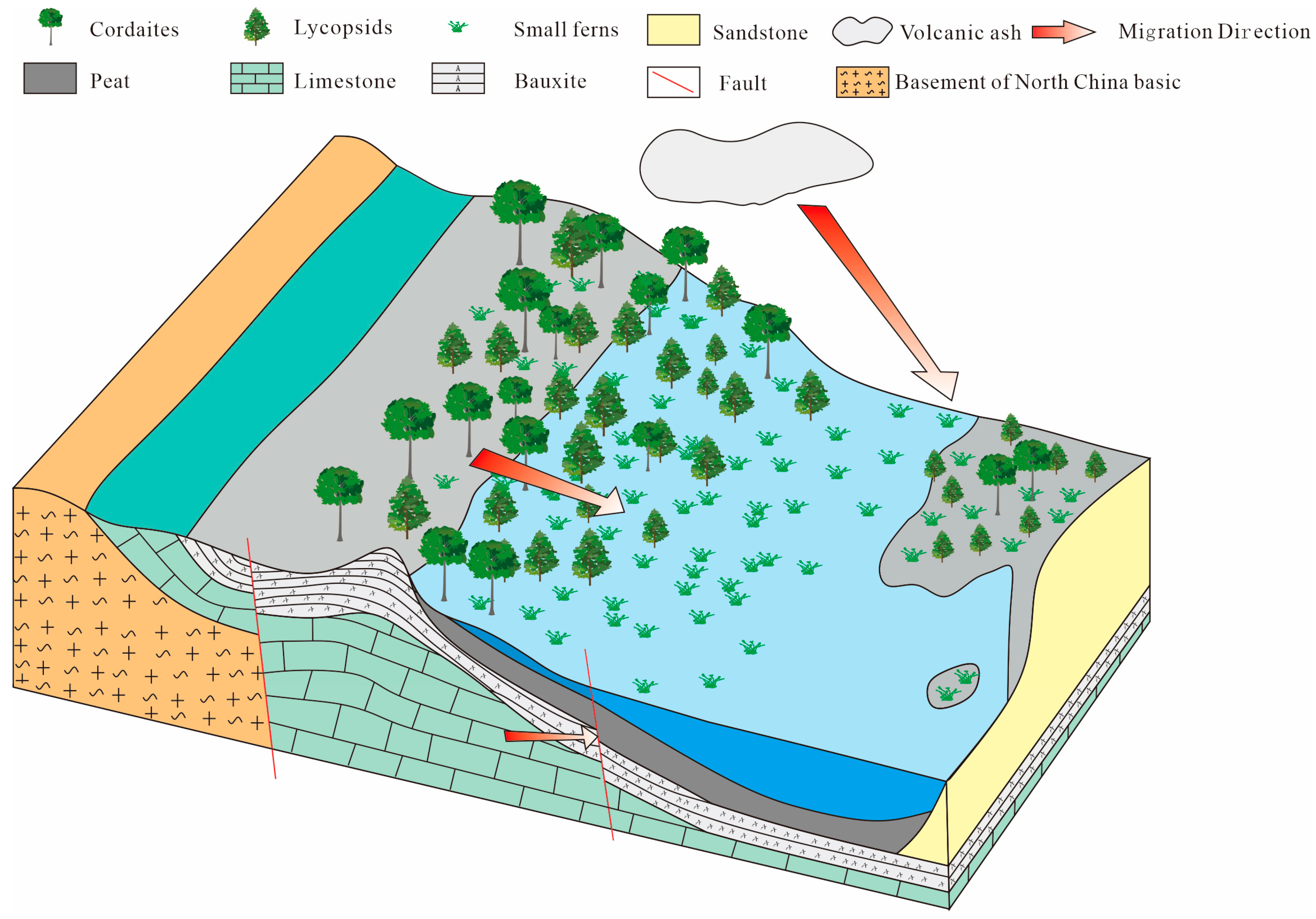
3.4. Enrichment Genesis of Heidaigou Coal–Ga Deposit

The Ga concentration in the No. 6 coal seam of the Jungar Coalfield significantly surpasses the arithmetic average of Ga in most Chinese coal seams, which is 6.64 μg/g [25]. This elevated concentration can be attributed to the provenance, paleo-sedimentary tectonic conditions, and paleoenvironmental factors. Boehmite serves as the primary carrier of Ga in coal [13,20,43]. During the formation of the 6-6 coal in the Jungar Coalfield, the terrain was elevated in the northwest and declined towards the southeast. The terrigenous clasts predominantly originated from the Middle Archaic, more extensively distributed in the northwestern region of the Yinshan Paleoclast [67,68,69,70,71,72,73,74,75]. In the Heidaigou coal–Ga deposit, the primary source of Ga in the coal is bauxite. During the deposition of the No. 6 seam (comprising 6-2, 6-3, 6-4, 6-5), the northeastern part of the coalfield began to elevate, revealing the bauxite of the Benxi Formation at the surface. Concurrently, the coalfield was situated in a low-lying area between the northwestern Yinshan Paleoclasts and the northeastern uplift of the Benxi Formation [76]. The coal-bearing strata of the Jungar Coalfield are rich in clay minerals, which are prevalent not only within the coal seams but also in the strata above and below the seams [20]. The boehmite in the middle of the No. 6 coal seam of the Heidaigou coal–Ga deposit is morphologically varied, with part of the boehmite filling in the cell for the colloidal genesis, which is the result of the primary condition [13,14]. The enrichment of Ga in the top and bottom plates of the coal seams indicates that the Ga-containing carriers in the clay minerals entered the coal seams through the surrounding rocks under the action of groundwater, showing the influence of catagenesis, which indicates that the catagenesis leaching action and the activity of groundwater are other factors contributing to the enrichment of Ga in the Heidaigou coal–Ga deposit [20]. Moreover, in the clayey conglomerate of the Heidaigou coal series, significant quantities of volcanic clasts and volcanic ash have been identified [67,77,78,79]. Earlier research on the Taiyuan Formation revealed thin layers of volcanic tuff [80], indicating that these volcanic tuff layers and clasts might have originated from volcanic activities along the orogenic belt at the boundary of the North China and South Mongolia Plates. This suggests an additional source of aluminum, Ga, and clay materials (Figure 5).

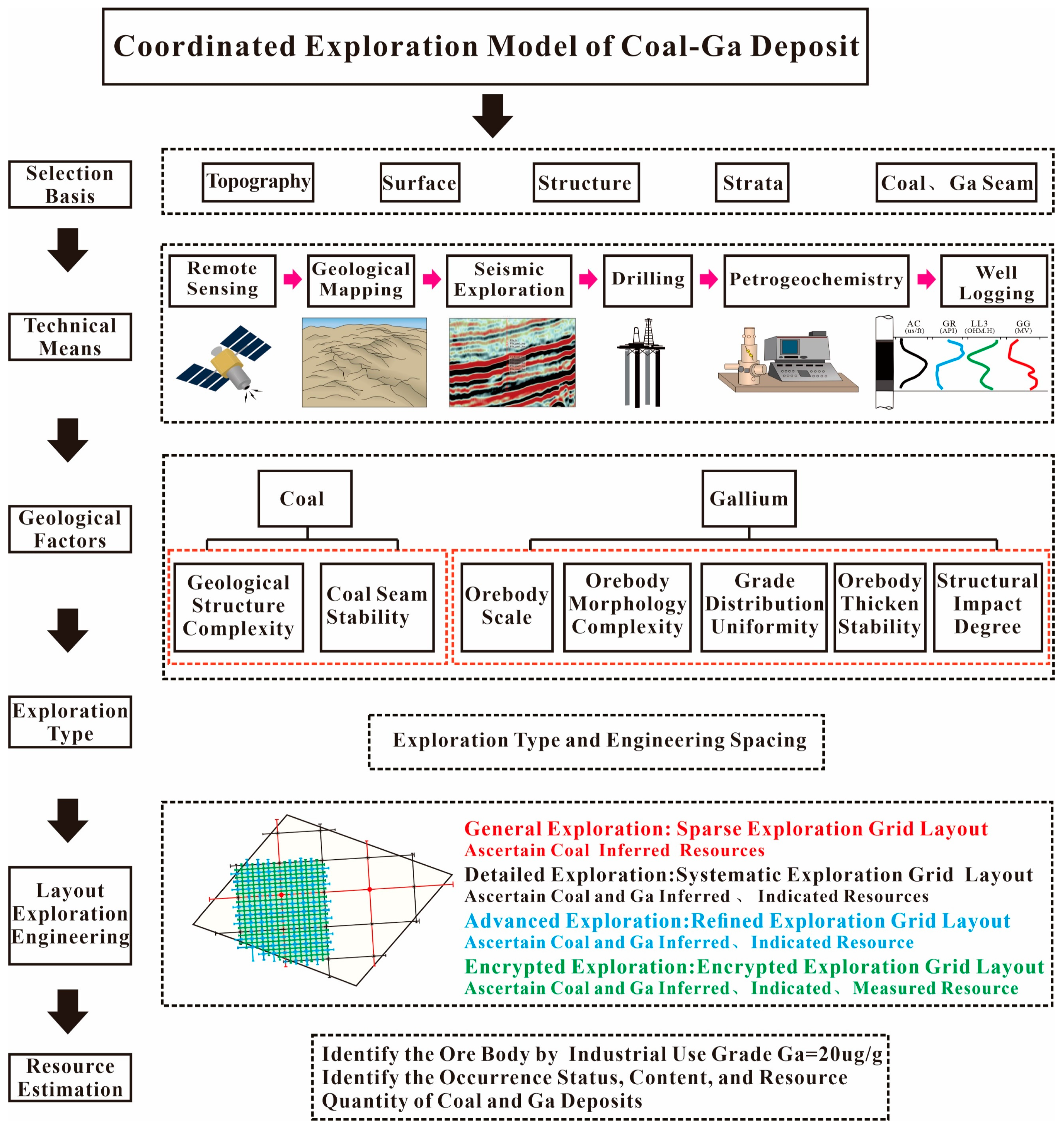
4. Cooperative Exploration Model of Coal–Ga Deposit

4.1. Original Exploration Technical Means, Exploration Project Layout, and Resource Estimation

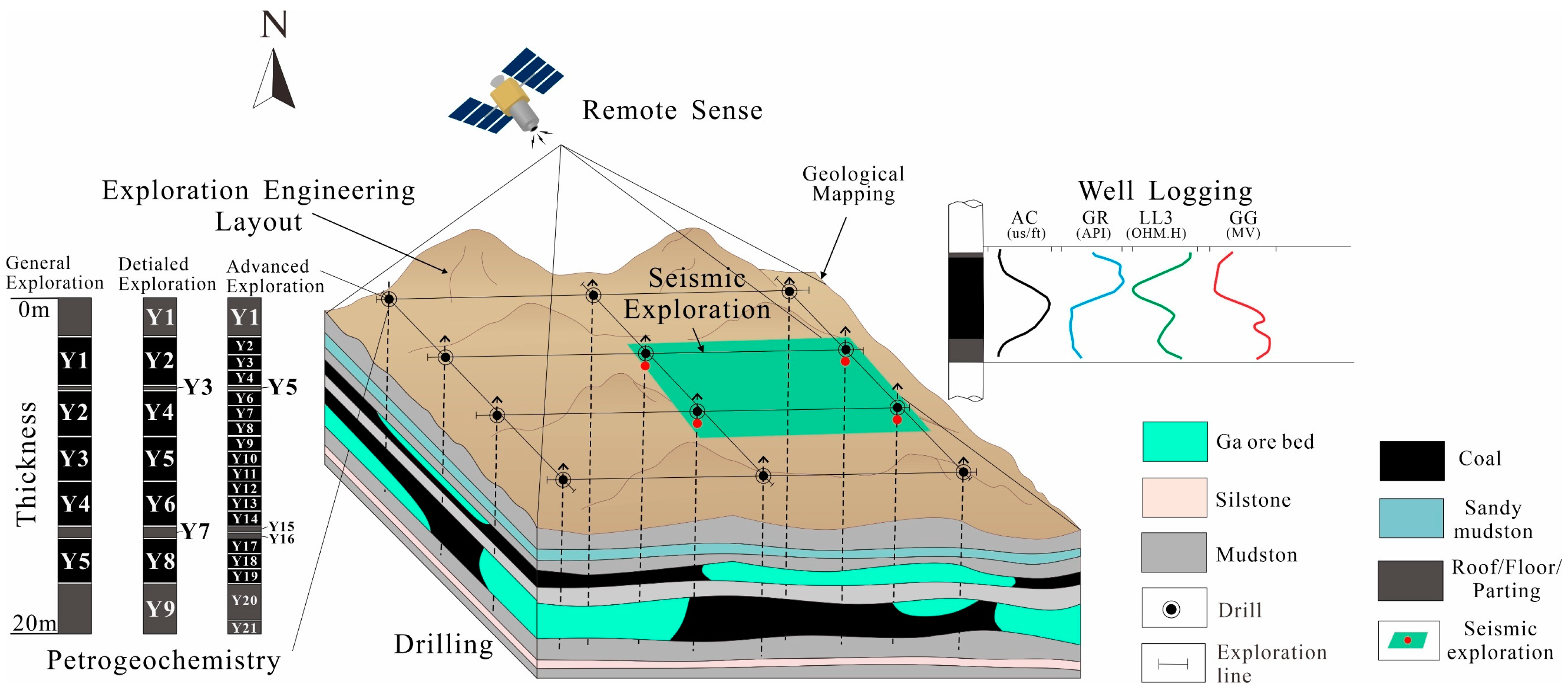
4.1.1. Exploration Technical Means

The original exploration employed traditional coal exploration techniques, considering the geological and topographical conditions, the complexity of structures, and the stratigraphic occurrence characteristics of the Heidaigou mining area, including drilling, 3D seismic, geophysical well logging, borehole pumping tests, engineering geological tests, petrogeochemistry, and engineering surveying. These methods were used to determine the occurrence state, concentration, and resource reserves of the coal–Ga deposits [65].

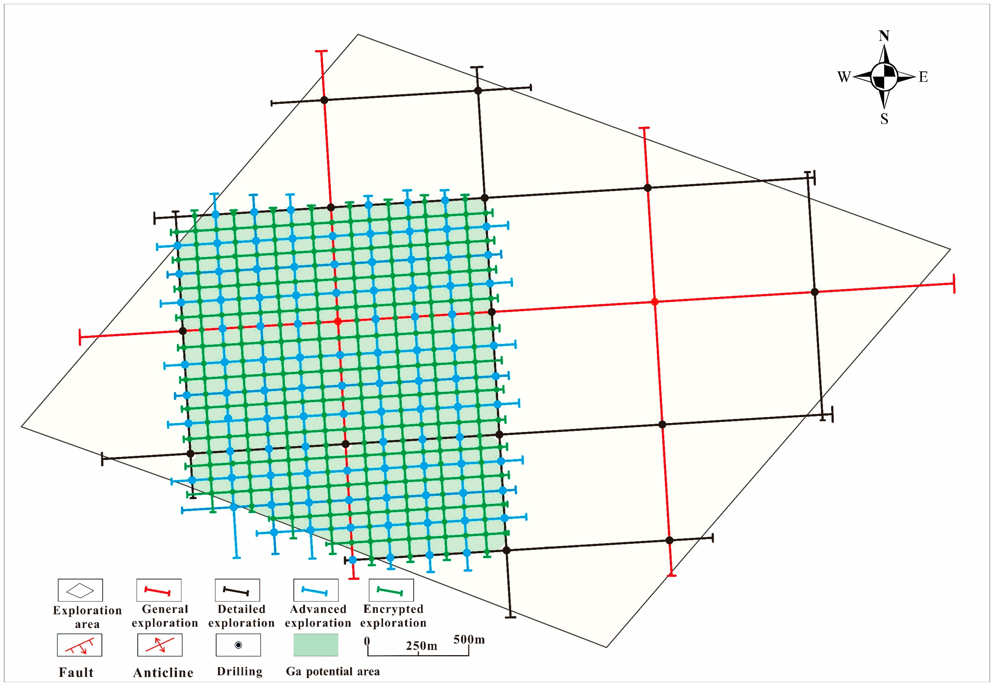
4.1.2. Layout of Exploration Engineering

The drilling layout of the original exploration was based on the exploration line profile method with vertical coal seams, the square exploration network system was selected for the exploration layout, and the exploration line direction was arranged along the coal seam trend and inclination. Previous exploration lines and boreholes were fully considered. The main exploration lines were spaced at 250 m, and the typical distance between boreholes was also 250 m. The feasibility resources of coal were defined by a grid of 1000 m × 1000 m, the measured resources of coal were defined by a grid of 250 m× 250 m, and the drilling was carried out to 10 m below the floor of the lowest coal seam to control the occurrence conditions of coal layer resources.

4.1.3. Resource Estimation

The original exploration did not estimate the Ga resource reserves, put forward the principle of determining the Ga grade, and used the geological ore block method to estimate the resource reserves. The coal resource reserves in all categories are determined by a square exploration network system with a corresponding mesh. In the original exploration, the stratified resource quantities of the 6-1, 6-2, 6-3, 6-4, 6-5, and 6-6 coal seams were estimated as proven resources. For the areas on both sides of the faults, the sections extending 30 m outward from the intersection lines of the faults and coal seams were considered as inferred resources.

4.2. Review of the Original Exploration Techniques, Exploration Project Layout, and Resource Estimation

4.2.1. Review of Exploration Technical Means

Remote Sensing: The entire exploration area is crisscrossed with valleys and largely covered by loess, making it a buried type of coal deposit. Remote sensing aerial surveys are used to create topographic maps. These maps provide comprehensive physical features, realistic geomorphic representations, the accurate and complete use of symbols, and evenly distributed annotations, meeting the requirements for exploration and construction mapping. Therefore, the choice of remote sensing in the original exploration was appropriate.
3D seismic: The 3D seismic exploration area is located in the central–northern part of the exploration area, centered around the speculated faults reported earlier. The area has poor surface geological conditions but favorable deep seismic geological conditions. The sedimentary environment of the No. 6 compound coal seam is relatively stable. By selecting appropriate full three-dimensional interpretation techniques, it is possible to precisely control the morphology of the coal seam floor undulations, faults, and collapse columns within the exploration area. Thus, the use of three-dimensional seismic technology in the original exploration was appropriate.
Drilling engineering: Most of the exploration area is covered by loess, the main strata exposed in the gullies are the Permian Lower and Upper Shihezi Formations, and the coal strata are not exposed. The depth of the uppermost recoverable coal seam (the No. 5 coal seam) is 65.43~180.04 m, indicating that it is a concealed coal deposit. The use of drilling engineering can accurately expose the stratigraphy, control the ore layer, collect samples, and determine the resources for the coal and Ga ore seams. Therefore, it is more appropriate to choose drilling engineering in the original exploration.
Petrogeochemistry: The collection of coal core samples strictly adheres to the Coal Resource Exploration Coal Sample Collection Procedures. Samples are promptly collected, sealed in plastic bags, and, after inspection and weighing, transported promptly to the laboratory for testing under conditions that ensure that the coal samples are sealed to prevent oxidation [81]. In the original exploration, samples were combined from the coal seam top, coal seam floor, and each layer of gangue. This approach failed to reflect the vertical variation of Ga, indicating that the sampling method in the initial exploration was not reasonable and did not follow the principles of technical efficacy and progressive implementation.
Well logging: The original exploration conducted well logging on all boreholes, complying with the Coal Field Geophysical Logging Standards for periodic calibration, scaling, and adjustment. This approach accurately determined the depth, thickness, structure, and stratigraphic position of mineable coal seams. It involved delineating geological profiles for boreholes; establishing the depth, thickness, and stratigraphic boundaries of each rock layer; enhancing the study of the geophysical properties of coal and rock layers; and comparing these to understand the occurrence, variation patterns, and depositional environment of coal seams. In the original exploration, conventional parameters from coal logging were used, which can distinguish the lithology and differentiate coal seams, floors, and partings. Acoustic logging can measure the elastic parameters of the coal rock, among which both the bulk modulus and modulus ratio have a significant correlation with the Ga concentration in coal rock [81]. This allows for the quantitative interpretation of the Ga concentration in the coal rock. Therefore, the choice of well logging technology and logging parameters in the original exploration was reasonable.

4.2.2. Review of the Layout of Exploration Engineering

The layout of exploration engineering in the original exploration followed the Mineral Geological Exploration Standards for Coal [65], determining that the structural complexity of the exploration area was simple. The primary exploitable coal seam, No. 6, was identified as stable, and the coal exploration was classified as Type 1, Category 2 [65]. The drilling project was principally arranged according to the exploration line profile method perpendicular to the strata, with a 250 m × 250 m grid for the delineation of the measured resource reserves and a 1000 m × 1000 m grid for the delineation of the indicated resource reserves. Areas with a grid larger than 1000 m × 1000 m or only controlled by sparse boreholes were designated for inferred resource reserves, meeting the line spacing requirements of the coal geological exploration standards. The original exploration focused solely on coal, with its layout designed accordingly, and did not consider the distribution of Ga resources, thus lacking a corresponding exploration project layout for Ga.

4.2.3. Review of Resource Estimation

In the original exploration, coal seams 5, 6-1, and 6-2 (high-ash coal) were delineated using the mine boundary, the exploitable boundary of the coal seam, and the boundary of weathered coal, respectively. Coal seams 6-3–6-6 were defined using the mine boundary and the boundary of weathered coal. These demarcations did not meet the basic requirements for the division of resource estimation blocks as stipulated in the Mineral Geological Exploration Standards for Coal [65].
In the original exploration, coal seams 6-1, 6-3, 6-4, 6-5, and 6-6 were estimated as measured economic base reserves. On both sides of the faults, extending 30 m from the intersection with the coal seam, the resources were classified as inferred resources. The area surrounding weathered coal was also considered a measured resource. Coal seam 6-2 was treated as a measured resource, with inferred resources extending 30 m from the fault intersections on both sides. Coal seam 5 was entirely classified as an inferred resource, not meeting the resource estimation requirements of the Mineral Geological Exploration Standards for Coal [65].
The original exploration estimated only coal reserves and did not assess Ga reserves. The method of combining samples from the coal seam roof, floor, and each layer of gangue during the original exploration did not reflect the vertical variation of Ga, leading to significant discrepancies in the estimated Ga resource quantity.

4.3. Optimization of Coal–Ga Deposit Cooperative Exploration Technology, Exploration Project Layout, and Resource Estimation

4.3.1. Optimization of Cooperative Exploration Technology Means

Based on the topography, surface characteristics, coal seam coverage, regional geological background, stratigraphic features, and characteristics of the coal and Ga ore layers in the exploration area, remote sensing, three-dimensional seismic assessments, drilling projects, geophysical logging (scatter gamma, natural gamma, tri-lateral resistivity, acoustic transit time, well deviation, well diameter), and petrogeochemistry were used to determine the scale, morphological complexity, thickness stability, and structural complexity of the coal and Ga deposits. Petrogeochemical exploration techniques were optimized for different exploration stages, adhering to the principles of specificity, progressive implementation, and economic rationality. During the general survey stage, a single full-layer sample was taken for coal seams thinner than 3 m, and one sample every 3 m for seams thicker than 3 m. The same sampling strategy was applied during the detailed survey stage. During the exploration stage, one sample was taken at every 1 m of the coal seam.
In the geophysical well logging analysis, the correlation of the Ga in coal and boehmite was utilized. The elastic parameters of coal and rock, measured throμgh acoustic well logging and seismic exploration, were used. Cross-plots of the bulk modulus and modulus ratio as interpretation templates enabled the quantitative interpretation of the Ga concentration in the core. Therefore, these geophysical response characteristics were used as geophysical indicators to obtain Ga resource estimates in the coal. In geophysical logging analysis, acoustic logging and seismic exploration are utilized to measure the elastic parameters of coal and rocks. By leveraging the correlation of the Ga and boehmite in coal, a cross-plot of the bulk modulus and modulus ratio can be employed for the quantitative interpretation of the Ga concentration in coal

4.3.2. Optimization of Cooperative Exploration Project Layout

In the coordinated exploration of coal and Ga resources, it is crucial to thoroμghly consider the uneven distribution and abrupt variations of elements, while adhering to the principle of implementing differentiated strategies across various zones. In the study area, different blocks should be delineated, and distinct engineering layout plans should be adopted for each block. Taking into account the occurrence of coal-bearing strata, Ga concentration distribution, and zoning, the layout of the exploration engineering system should be strategically determined. For the general survey stage, a square exploration grid system was used, while a rectangular exploration grid system was employed for the detailed exploration stages. The orientation of exploration lines should be established by thoroμghly evaluating the trend and inclination of coal seams, along with the variation patterns of the Ga concentration. For the rectangular exploration grid, the longer axis should be aligned in the northeast direction, perpendicular to the stratification of the coal and Ga layers, while the shorter axis should align in the northwest direction, perpendicular to the layer inclination. According to the specifications for coal exploration, it was determined that the stability degree of the coal seam in the exploration area was a stable type, the structural complexity was a simple type, and the exploration type of coal in the exploration area was class 1 and type 2 [65]. The sum of the five geological parameter types of the Ga layer was determined to be 3.0 according to the specifications for rare metal mineral exploration, so the Ga exploration type was type I [66].
Considering the exploration types of coal and Ga layers, the engineering spacing for coal and Ga deposits should be determined, and the exploration engineering layout should be conducted in stages. During the general survey stage, a square exploration grid system (1600 m × 1600 m) was used to understand the conditions of the coal layers and Ga and to delineate high-Ga areas. During the detailed exploration stages, a rectangular exploration grid system was employed, setting the indicated resource quantity grid for coal at 800 m × 600 m, and the measured resource quantity grid for coal at 400 m × 300 m. The indicated resource quantity grid for Ga was set at 200 m × 150 m, and the measured resource quantity grid for Ga at 100 m × 75 m. This optimization divided the southwest, southeast, and central zones of the exploration area into Ga resource potential areas, and cooperative exploration project layout optimization was carried out in this area (Figure 6).

4.3.3. Optimizing Resource Estimation

As the original exploration did not estimate Ga resources, this optimization used the minimum utilization concentration of Ga in coal (20 μg/g) as specified in the Guidelines for the Classification and Application of Valuable Elements in Coal [33]. The estimation of Ga resources was conducted with the planar boundary defined by the Ga = 20 μg/g isopleth.
Utilizing the geological block method and adhering to relevant standards, resource blocks were re-divided and coal resources for the principal mineable seams re-estimated. The geological block method was reused for the correct delineation of resource blocks and the reliable estimation of coal resources for the main recoverable coal seams and Ga based on the corresponding specifications.

4.4. Coal–Ga Deposit Cooperative Exploration Model

Due to the trace and dispersed nature of Ga in coal, it is challenging to explore and develop it as an independent mineral species. However, the enrichment of Ga in coal-bearing sedimentary processes and its coexistence with coal and coal measures dictate that simultaneous coal and Ga exploration is a necessary approach, grounded in theory, technically feasible, economically rational, and strategically required. Building upon the investigation into the occurrence characteristics of Ga in coal and coal measures, as well as the regional metallogenic mechanisms, the principles for the coordinated exploration of Ga-containing coal and coal measures have been refined. Following the existing coal exploration models and the principle of maximizing benefits and interests, technical methods for the coordinated exploration of coal-associated Ga and exploration engineering layout plans have been proposed, thus constructing a model for the joint exploration of coal and Ga (Figure 7).
The process of the coal–Ga deposit collaborative exploration model follows the principle of research first (Figure 8). Coal–Ga cooperative exploration should be based on the study of Ga enrichment mechanisms, compositional types, and occurrence patterns in coal measures. It should utilize multidisciplinary theories like coalfield geology, geochemistry, mineralogy, and exploration engineering as a foundation. Supported by a coordinated exploration technology system composed of key technologies like precision drilling, detailed geophysical exploration, and fine exploration, and guided by standards such as coal exploration norms and solid mineral exploration norms, this approach involves analyzing the rationality of existing exploration technical methods (combinations) and engineering layout plans from aspects such as the orebody distribution, the control of the orebody morphology by drilling projects, the selection of drilling project layout systems, exploration line layout direction, and exploration project spacing. Proposals are made for the combination of technical methods for coal-type Ga exploration and exploration engineering layout plans based on existing coal exploration models and the principle of maximizing benefits and interests. This approach is designed to elucidate the occurrence characteristics and geological conditions conducive to Ga development in coal, ascertain the associated resource quantities, and establish a geological framework for the comprehensive development and utilization of Ga within coal.
A remote sensing aerial survey is used to determine the main topographical and geomorphological features, exposed rock types, and coal seam coverage. Geological mapping preliminarily establishes stratigraphic sequences, the geological characteristics of coal-bearing strata, and geological structural features. Three-dimensional seismic exploration precisely determines the depth, thickness, structure, and stratigraphic position of mineable coal seams; understands the coal seam occurrence, variation patterns, and depositional environment; and infers the nature and morphology of underground strata. Drilling projects reveal the stratigraphic positions of Ga ore layers, and the collection of geochemical samples and estimation of coal resources are carried out, with drilling depths set at 15 to 20 m below the designed mining layer. Petrogeochemistry is an important basis for the accurate evaluation of mineral resources. It is used to test the concentration of Ga in coal, assess its occurrence characteristics, and estimate Ga resources. All boreholes in the exploration undergo geophysical well logging, with the logging parameters primarily selected for lithological division, coal seam differentiation, and the qualitative determination of the coal seam thickness. Acoustic well logging and seismic exploration are used to measure the elastic parameters of coal and rock. Cross-plots of the bulk modulus and modulus ratio serve as interpretation templates for the quantitative interpretation of the Ga concentration in the core.
Based on the occurrence state of coal and coal measures both on the surface and vertically, geological factors such as the thickness stability of coal seams, structural complexity, scale of Ga ore layers, morphological complexity of ore bodies, uniformity of grade distribution, thickness stability of ore bodies, and the extent of structural influences are determined. This information is used to determine the exploration type of coal and Ga deposits and a reasonable joint exploration engineering layout plan. Ultimately, the identification of coal and Ga deposit resources provides a geological foundation for the integrated development and utilization of these mineral resources.

5. Conclusions

(1)
The Heidaigou coal–Ga deposit exhibits a distinct enrichment pattern, with the Ga concentration generally decreasing from the central–northern part of the exploration area towards the northeast and southeast. Vertically, the Ga concentration is unevenly distributed within the coal seam and adjacent boreholes show similar distribution characteristics.
(2)
Considering the distribution characteristics of the Heidaigou coal–Ga deposit and the efficacy of exploration techniques for coal and Ga, the exploration methodologies, project configurations, and resource estimates outlined in the original report have been thoroughly reviewed and refined.
(3)
The cooperative exploration model for coal–Ga deposits emphasizes the distribution of ore bodies, managing the impact of drilling projects on the morphology of these ore bodies, and making systematic decisions regarding the layout of exploration engineering and the concentration of Ga, providing the basis for the estimation of Ga resources.

Author Contributions

Data curation, Y.Z.; formal analysis, Y.Z., Y.W. and X.L.; methodology, Y.W., D.C. and X.L.; resources, Y.W., J.W., L.X., B.D. and T.X.; supervision, D.C. and Y.W.; writing—original draft, Y.Z.,Y.W. and X.L. All authors have read and agreed to the published version of the manuscript.

Funding

This research was funded by the National Key Research and Development Plan of China, (2021YFC2902004), the National Natural Science Foundation of China (grant No. 42372187, 41972174), and the Special Project for Geological development of Ningxia in 2023 (640000233000000011005).

Data Availability Statement

Data are contained within the article.

Conflicts of Interest

The authors declare no conflicts of interest.

References

  1. Amir, H.A.A.A.; Fakhri, M.A.; Alwahib, A.A. Review of GaN optical device characteristics, applications, and optical analysis technology. Mater. Today Proc. 2021, 42, 2815–2821. [Google Scholar] [CrossRef]
  2. Pearton, S.J.; Zolper, J.C.; Shul, R.J.; Ren, F. GaN: Processing, defects, and devices. Appl. Phys. Rev. 1999, 86, 1–78. [Google Scholar] [CrossRef]
  3. Baliga, B.J. Gallium nitride devices for power electronic applications. Semicond. Sci. Technol. 2013, 28, 074011. [Google Scholar] [CrossRef]
  4. Kaur, D.; Ghosh, A.; Kumar, M.A. Strategic review on gallium oxide based power electronics: Recent progress and future prospects. Mater. Today Commun. 2022, 33, 104244. [Google Scholar]
  5. Zhou, J.G.; Chen, H.; Fu, K.; Zhao, Y.J. Gallium oxide-based optical nonlinear effects and photonics devices. J. Mater. Res. 2021, 36, 4832–4845. [Google Scholar] [CrossRef]
  6. Lee, S.W.; Luna, M.L.; Berdunov, N.; Wan, W.M.; Kunze, S.; Shaikhutdinov, S. Unraveling surface structures of gallium promoted transition metal catalysts in CO2 hydrogenation. Nat. Commun. 2023, 14, 4649. [Google Scholar] [CrossRef]
  7. Broom, R.F.; Gooch, C.H.; Hilsum, C.; Oliver, D.J. Onset of stimulated emission from gallium arsenide semiconductor optical masers. Nature 1963, 198, 368–369. [Google Scholar] [CrossRef]
  8. Lu, X.F.; Wang, L.; Wang, X.D.; Niu, X.K. Research Progress in Gallium Recovery Technology. Nonferrous Met. 2008, 60, 105–108+114. (In Chinese) [Google Scholar]
  9. Phipps, G.; Mikolajczak, C.; Guckes, T. Indium and Gallium: Long-term supply. Renew. Energy Focus 2008, 9, 56–59. [Google Scholar] [CrossRef]
  10. Qin, S.J.; Sun, Y.Z.; Li, Y.H.; Wang, J.X.; Zhao, C.L.; Gao, K. Coal deposits as promising alternative sources for gallium. Earth-Sci. Rev. 2015, 150, 95–101. [Google Scholar] [CrossRef]
  11. Dai, S.F.; Finkelman, R.B. Coal as a promising source of critical elements: Progress and future prospects. Int. J. Coal Geol. 2018, 186, 155–164. [Google Scholar] [CrossRef]
  12. Seredin, V.V.; Dai, S.F.; Sun, Y.Z.; Chekryzhov, I.Y. Coal deposits as promising sources of rare metals for alternative power and energy-efficient technologies. Appl. Geochem. 2013, 31, 1–11. [Google Scholar] [CrossRef]
  13. Dai, S.F.; Ren, D.Y.; Li, S.S. The discovery of super-large gallium deposit in the Jungar Coalfield, Inner Mongolia, China. Chin. Sci. Bull. 2006, 2, 177–185. (In Chinese) [Google Scholar]
  14. Dai, S.F.; Ren, D.Y.; Li, S.S.; Chou, C.L. A Discovery of Extremely-enriched Boehmite from Coal in the Jungar Coalfield, the Northeastern Ordos Basin. Acta Geol. Sin. 2006, 2, 294–300, 315–316, (In Chinese with English Abstract). [Google Scholar]
  15. Dai, S.F.; Li, D.; Chou, C.L.; Zhao, L.; Zhang, Y.; Ren, D.Y.; Ma, Y.W.; Sun, Y.Y. Mineralogy and geochemistry of boehmite-rich coals: New insights from the Haerwusu Surface Mine, Jungar Coalfield, Inner Mongolia, China. Int. J. Coal Geol. 2008, 74, 185–202. [Google Scholar] [CrossRef]
  16. Dai, S.F.; Jiang, Y.F.; Ward, C.R.; Gu, L.D.; Seredin, V.V.; Liu, H.D.; Zhou, D.; Wang, X.B.; Sun, Y.Z.; Zou, J.H.; et al. Mineralogical and geochemical compositions of the coal in the Guanbanwusu Mine, Inner Mongolia, China: Further evidence for the existence of an Al (Ga and REE) ore deposit in the Jungar Coalfield. Int. J. Coal Geol. 2012, 98, 10–40. [Google Scholar] [CrossRef]
  17. Dai, S.F.; Ren, D.Y.; Chou, C.L.; Finkelman, R.B.; Seredin, V.V.; Zhou, Y. Geochemistry of trace elements in Chinese coals: A review of abundances, genetic types, impacts on human health, and industrial utilization. Int. J. Coal Geol. 2012, 94, 3–21. [Google Scholar] [CrossRef]
  18. Qin, Y.; Wang, W.F.; Cheng, A.G.; Liu, X.H.; Zhao, J.L. Study of ore-forming potential of gallium in coal for the first group of state programmed mining districts. Coal Geol. China. 2009, 21, 17–21. (In Chinese) [Google Scholar]
  19. Yi, T.S.; Qin, Y.; Wu, Y.Y.; Li, Z.F. Gallium Accumulation and Geological Controls in Coal Seam and Its Floor from Liangshan Formation, Kaili, Eastern Guizhou, China. J. China Univ. Min. Technol. 2007, 36, 331–334, (In Chinese with English Abstract). [Google Scholar]
  20. Wang, W.F.; Qin, Y.; Liu, X.H.; Zhao, J.L.; Wang, J.Y.; Wu, G.D.; Liu, J.T. Distribution, occurrence and enrichment causes of gallium in coals from the Jungar Coalfield, Inner Mongolia. Sci. China, Ser. D Earth Sci. 2011, 41, 181–196. (In Chinese) [Google Scholar] [CrossRef]
  21. Chu, G.C.; Xiao, L.; Jin, Z.; Lin, M.Y.; Blokhin, M.G. The Relationship between Trace Element Concentrations and Coal-Forming Environments in the No. 6 Coal Seam, Haerwusu Mine, China. Energy Explor. Exploit. 2015, 33, 91–104. [Google Scholar] [CrossRef]
  22. Jiu, B.; Huang, W.H.; Spiro, B.; Hao, R.; Mu, N.N.; Wen, L.; Hao, H.D. Distribution of Li, Ga, Nb, and REEs in coal as determined by LA-ICP-MS imaging: A case study from Jungar coalfield, Ordos Basin, China. Int. J. Coal Geol. 2023, 267, 104184. [Google Scholar] [CrossRef]
  23. Jiu, B.; Jin, Z.J.; Wang, Z.G. Multiscale in-situ elemental characterization of critical elements in low rank coal, implications for modes of occurrence. Fuel 2023, 349, 128632. [Google Scholar] [CrossRef]
  24. Sun, Y.Z.; Zhao, C.L.; Li, Y.H.; Wang, J.X.; Zhang, J.Y.; Jin, Z.; Lin, M.Y.; Wolfgang, K. Further Information of the Associated Li Deposits in the No.6 Coal Seam at Jungar Coalfield, Inner Mongolia, Northern China. Acta Geol. Sin. (Engl. Ed.) 2013, 87, 1097–1108. [Google Scholar]
  25. Sun, Y.Z.; Zhao, C.L.; Qin, S.J.; Lin, B.; Li, Z.S.; Lin, M.Y. Occurrence of some valuable elements in the unique ‘high-aluminium coals’ from the Jungar coalfield, China. Ore Geol. Rev. 2015, 72, 659–668. [Google Scholar] [CrossRef]
  26. Xiao, L.; Zhao, B.; Duan, P.P.; Shi, Z.X.; Ma, J.L.; Lin, M.Y. Geochemical Characteristics of Trace Elements in the No. 6 Coal Seam from the Chuancaogedan Mine, Jungar Coalfield, Inner Mongolia, China. Minerals 2016, 6, 28. [Google Scholar] [CrossRef]
  27. Zhao, C.L.; Qin, S.J.; Yang, Y.C.; Li, Y.H.; Lin, M.Y. Concentration of gallium in the Permo-carboniferuos coal of China. Energy Explor. Exploit. 2009, 27, 333. [Google Scholar] [CrossRef]
  28. Wei, Y.C.; He, W.B.; Qin, G.H.; Fan, M.H.; Cao, D.Y. Lithium Enrichment in the No. 21 Coal of the Hebi No. 6 Mine, Anhe Coalfield, Henan Province, China. Minerals 2020, 10, 521. [Google Scholar] [CrossRef]
  29. Wei, Y.C.; He, W.B.; Qin, G.H.; Wang, A.M.; Cao, D.Y. Mineralogy and Geochemistry of the Lower Cretaceous Coals in the Junde Mine, Hegang Coalfield, Northeastern China. Energies 2022, 15, 5078. [Google Scholar] [CrossRef]
  30. Sun, S.L.; Wu, G.Q.; Cao, D.Y.; Ning, S.Z.; Qiao, J.W.; Zhu, H.X.; Han, L.; Zhu, S.F.; Miao, Q.; Zhou, J.; et al. Coal measure mineral resources and their development trend. Coal Geol. China. 2014, 26, 1–11. (In Chinese) [Google Scholar]
  31. Ren, D.Y.; Zhao, F.H.; Dai, S.F.; Zhang, J.Y.; Luo, K.L. Geochemistry of Trace Elements in Coal; Science Press: Beijing, China, 2006. (In Chinese) [Google Scholar]
  32. DZ/T 0400-2022; Standard of Mineral Resources and Reserves Scale. Geological Publishing House: Beijing, China, 2022. (In Chinese)
  33. GB/T 41042-2021; Guidance for Utilization and Classification of Concentration of Valuable Elements in Coal. Standards Press of China: Beijing, China, 2021. (In Chinese)
  34. Ning, S.Z.; Cao, D.Y.; Zhu, S.F.; Qiao, J.W.; Wei, Y.C.; Deng, X.L.; Zhang, J.Q.; Li, C.C. Discussion on comprehensive evaluation technical method of coal resources. China Min. Mag. 2019, 28, 73–79. [Google Scholar]
  35. Tang, X.Y.; Huang, W.H. Trace Elements in Chinese Coal; The Mercial Press: Beijing, China, 2004. (In Chinese) [Google Scholar]
  36. Liu, G.J.; Yang, P.Y.; Peng, Z.C.; Wang, G.L.; Cao, Z.H. Occurrence of trace elements in coal of Yanzhou mining district. Geochimica 2002, 31, 85–90. (In Chinese) [Google Scholar]
  37. Mukherjee, K.N.; Dutta, N.R.; Chandra, D.; Pandalai, H.S.; Singh, M.P. A statistical approach to the study of the distribution of trace elements and their organic/ inorganic affinity in lower Gondwana coals of India. Int. J. Coal Geol. 1988, 10, 99–108. [Google Scholar] [CrossRef]
  38. Dai, S.F.; Finkelman, R.B.; French, D.; Hower, J.C.; Graham, I.T.; Zhao, F.H. Modes of occurrence of elements in coal: A critical evaluation. Earth-Sci. Rev. 2021, 222, 103815. [Google Scholar] [CrossRef]
  39. Seredin, V.V.; Finkelman, R.B. Metalliferous coals: A review of the main genetic and geochemical types. Int. J. Coal Geol. 2008, 76, 253–289. [Google Scholar] [CrossRef]
  40. Bennett, R.; Czechowski, F. Gallium porphyrins in bituminous coal. Nature 1980, 283, 465–467. [Google Scholar] [CrossRef]
  41. Bonnett, R.; Cousins, R.P.C. On the metal concentration and metal ion uptake of botanically specific peats and the derived humic acids. Org. Geochem. 1987, 11, 497–503. [Google Scholar] [CrossRef]
  42. Bonnett, R. Porphyrins in coal. Int. J. Coal Geol. 1996, 32, 137–149. [Google Scholar] [CrossRef]
  43. Dai, S.F.; Ren, D.Y.; Chou, C.L.; Li, S.S.; Jiang, Y.F. Mineralogy and geochemistry of the No. 6 Coal (Pennsylvanian) in the Jungar Coalfield, Ordos Basin, China. Int. J. Coal Geol. 2006, 66, 253–270. [Google Scholar] [CrossRef]
  44. Swaine, D.J. Trace Elements in Coals; Butterworth: London, UK, 1990. [Google Scholar]
  45. Eskenazy, G. Adsorption of gallium on peat and humic acids. Fuel 1967, 46, 187. [Google Scholar]
  46. Ward, C.R.; Gurba, L.W. Chemical composition of macerals in bituminous coals of the Gunnedah Basin, Australia, using electron microprobe analysis techniques. Int. J. Coal Geol. 1999, 39, 279–300. [Google Scholar] [CrossRef]
  47. Mukherjee, K.N.; Dutta, N.R.; Chandra, D.; Singh, M.P. Geochemistry of trace elements of Tertiary coals of India. Int. J. Coal Geol. 1992, 20, 99113. [Google Scholar] [CrossRef]
  48. Mastalerz, M.; Drobniak, A. Gallium and germanium in selected Indiana coals. Int. J. Coal Geol. 2012, 94, 302–313. [Google Scholar] [CrossRef]
  49. Li, J.; Zhuang, X.G.; Yuan, W.; Liu, B.; Querol, X.; Font, O.; Moreno, N.; Li, J.F.; Gang, T.; Liang, G.K. Mineral composition and geochemical characteristics of the Li-Ga-rich coals in the Buertaohai-Tianjiashipan mining district, Jungar Coalfield, Inner Mongolia. Int. J. Coal Geol. 2016, 167, 157–175. [Google Scholar] [CrossRef]
  50. Xu, S.S.; Wang, T.; Sun, S.L.; Cao, D.Y.; Li, Z.X. New Architecture of Integrated Coal Resource Exploration Technology in China. Coal Geol. China 2009, 21, 1–5. (In Chinese) [Google Scholar]
  51. Cao, D.Y.; Wei, Y.C. Coal Geological Exploration and Evaluation; China University of Mining and Technology Press: Xuzhou, China, 2021. (In Chinese) [Google Scholar]
  52. Cao, D.Y.; Lin, Z.Y.; Wei, Y.C.; Li, X.M.; Zhang, J.K.; Zheng, Z.H. Types and models of coal-deposit exploration in China. Energy Explor. Exploit. 2011, 29, 495–515. [Google Scholar] [CrossRef]
  53. Wei, Y.C.; Cao, D.Y.; Xia, Y.X.; Zhang, Q.; Li, Y.F.; Wei, Z.D.; Zhu, W.W. Discussion on Exploration Methods of Coal Resources in Areas with Complex Geologic Conditions. Coal Eng. 2014, 46, 115–117. (In Chinese) [Google Scholar]
  54. Wang, H.H.; Wang, Y.J.; Zhu, Y.Z.; Shen, L.J.; Li, H.K.; Li, X.Z.; Zhou, M.L.; Zhang, X.B.; Shao, Y.B.; Zhang, W.Y.; et al. Theoretical Research on “Coal-iron Co-basin”and“Iron Finding under Coal”Engineering Practice in the Coal-producing Region of North China—A Case Study of Iron-rich Ore Finding in the Yellow River North Coalfield in Shandong. Coal Geol. China 2023, 35, 7–11. (in Chinese). [Google Scholar]
  55. Wang, H.H.; Shen, L.J.; Wang, D.D.; Zhu, Y.Z.; Li, Z.X.; Wang, Y.J.; Mao, Q. Study on Mesozoic magmatic intrusion and Paleozoic multi-mineral genesis mechanism in Huanghebei Coalfield, Shandong Province. Coal Geol. Explor. 2021, 49, 83–92. (In Chinese) [Google Scholar]
  56. Wang, H.H.; Zhang, X.B.; Wang, Y.J.; Zhu, Y.Z.; Shen, L.J. Progress in Research on Multi-mineral Co-exploration Theory and Technology System in Mega Thick Overburden Area to the North of Yellow River. Coal Geol. China. 2020, 32, 150–154+166. (In Chinese) [Google Scholar]
  57. Li, Z.X.; Wang, D.D.; Lyu, D.W.; Li, Y.; Liu, H.Y.; Wang, H.H.; Wang, P.L. Study progress on coal measure mineral type and coordinated exploration: Discussion on conception standardized issues of coal geology. Coal Sci. Technol. 2018, 46, 164–176+201, (In Chinese with English Abstract). [Google Scholar]
  58. Li, Z.X.; Wang, T.; Wang, H.H.; Lyu, D.W.; Liu, H.Y. Theory and Technical System Study on Multiple Energy Mineral Resources Exploration in Coordination. Coal Geol. China 2011, 23, 68–72. (In Chinese) [Google Scholar]
  59. Duan, Z.K.; Xu, G.Z.; He, X.L. On Basic Principles in Integrated Coal Exploration in Company with Uranium and Evaluation Technology. Coal Geol. China 2015, 27, 1–4+17. (In Chinese) [Google Scholar]
  60. Wang, T.; Sun, J.; Jiang, T.; Lin, Z.Y.; Zhang, F.; Zhao, X.; Xie, Z.Q. Basic configuration and scientific problems of coal eco-geological survey. J. China Coal Soc. 2020, 45, 276–284. (In Chinese) [Google Scholar]
  61. Wang, T.; Han, X.Z.; Deng, J.; Sun, Y.J.; Li, Z.X.; Tang, S.H.; Mao, S.J. Orientation and major research problems of coal geological exploration in China under new conditions. Coal Geol. Explor. 2023, 51, 27–44. (In Chinese) [Google Scholar]
  62. Wei, Y.C.; Li, X.; Cao, D.Y.; Zhang, Y.; Wei, J.H.; Xu, L.X.; Wang, A.M. Cooperative exploration methods of coal and strategic metal resources in coal-bearing strata in China. Coal Sci. Technol. 2023, 51, 27–41. (In Chinese) [Google Scholar]
  63. Cao, D.Y.; Wei, Y.C.; Li, X.; Zhang, Y.; Xu, L.X.; Wei, J.H.; Dong, B. Discussion on the theory and technical framework of cooperative exploration of coal andstrategic metal resources in coal-bearing strata. J. China Coal Soc. 2024, 49, 1–16. (In Chinese) [Google Scholar]
  64. Zhao, G.R.; Ma, L.J.; Yang, F.T.; Lu, Z.S. Geological Report of Exploration in Heidaigou Mining Area, Jungar Coalfield, Inner Mongolia; Mongolia Coalfield Geological Company: Hohhot, China, 1982. (In Chinese) [Google Scholar]
  65. DZ/T 0215-2020; Specifications for Coal Exploration. Geological Publishing House: Beijing, China, 2020. (In Chinese)
  66. DZ/T 0203-2020; Specifications for Rare Metal Mineral Exploration. Geological Publishing House: Beijing, China, 2020. (In Chinese)
  67. Zhang, Z.H.; Lyu, D.W.; Hower, J.C.; Wang, L.J.; Shen, Y.Y.; Zhang, A.C.; Xu, J.C.; Gao, J. Geochronology, mineralogy, and geochemistry of tonsteins from the Pennsylvanian Taiyuan Formation of the Jungar Coalfield, Ordos Basin, North China. Int. J. Coal Geol. 2023, 267, 104183. [Google Scholar] [CrossRef]
  68. Wang, L.J.; Lyu, D.W.; Hower, J.C.; Zhang, Z.H.; Raji, M.; Tang, J.G.; Liu, Y.M.; Gao, J. Geochemical characteristics and paleoclimate implication of Middle Jurassic coal in the Ordos Basin, China. Ore Geol. Rev. 2022, 144, 104848. [Google Scholar] [CrossRef]
  69. Gao, J.; Lyu, D.W.; Loon, T.; Hower, J.C.; Raji, M.; Yang, Y.; Ren, Z.H.; Wang, Y.J.; Zhang, Z.H. Reconstruction of provenance and tectonic setting of the Middle Jurrasic Yan’an Formation (Ordos Basin, North China) by analysis of major, trace and rare earth elements in the coals. Ore Geol. Rev. 2022, 151, 105218. [Google Scholar] [CrossRef]
  70. Zhang, Y.Z.; Xiao, L. Petrographic characteristics and depositional environment of No. 6 coal from Xiaoyμgou Mine, Jungar Coalfield, China. Int. J. Coal Sci. Technol. 2014, 1, 395–401. [Google Scholar] [CrossRef]
  71. Liu, C.; Chang, X.D.; Sun, B.L.; Zeng, F.G. New Insight into the Depositional Age of No. 6 Coal in Heidaigou Mine, Late Paleozoic Jungar Coalfield, Inner Mongolia, China. Sustainability 2021, 14, 6297. [Google Scholar] [CrossRef]
  72. Hao, R.W.; Li, X.L.; Xu, P.J.; Liu, Q.F. Thermal activation and structural transformation mechanism of kaolinitic coal gangue from Jungar coalfield, Inner Mongolia, China. Appl. Clay Sci. 2022, 223, 106508. [Google Scholar] [CrossRef]
  73. Liu, D.N.; Lin, J.W.; Zhou, A.C.; Zhao, F.H.; Zhou, R.; Zou, Y. Tectono-Thermal Events of Coal-Bearing Basin in the Northern North China Craton: Evidence from Zircon–Apatite Fission Tracks and Vitrinite Reflectance. Minerals 2022, 12, 942. [Google Scholar] [CrossRef]
  74. Liu, Z.F.; Wei, Y.C.; Ning, S.Z.; Jia, X.; Qin, R.F.; Cao, D.Y. The differences of element geochemical characteristics of the main coal seams in the Ningdong coalfield, Ordos Basin. J. Geochem. Explor. 2019, 202, 77–91. [Google Scholar]
  75. Qin, G.H.; Cao, D.Y.; Wei, Y.C.; Wang, A.M.; Liu, J.C. Geochemical characteristics of the Permian coals in the Junger-Hebaopian mining district, northeastern Ordos Basin, China: Key role of paleopeat-forming environments in Ga-Li-REY enrichment. J. Geochem. Explor. 2020, 213, 106494. [Google Scholar] [CrossRef]
  76. Wang, S.M. Coal Aggregation Pattern and Coal Resource Evaluation in Ordos Basin; China Coal Industry Publishing House: Beijing, China, 1996; (In Chinese with English Abstract). [Google Scholar]
  77. Zhang, S.; Xiu, W.; Sun, B.; Liu, Q.F. Provenance of multi-stage volcanic ash recorded in the Late Carboniferous coal in the Jungar Coalfield, North China, and their contribution to the enrichment of critical metals in the coal. Int. J. Coal Geol. 2023, 273, 104265. [Google Scholar] [CrossRef]
  78. Zhang, S.; Yuan, T.C.; Sun, B.; Li, L.; Ma, X.J.; Shi, S.L.; Liu, Q.F. Formation of boehmite throμgh desilication of volcanic-ash-altered kaolinite and its retention for gallium: Contribution to enrichment of aluminum and gallium in coal. Int. J. Coal Geol. 2024, 281, 104404. [Google Scholar] [CrossRef]
  79. Wang, L.J.; Lyu, D.W.; Zhang, Z.H.; Hower, J.C.; Raji, M.; Zhang, Y.S.; Shen, Y.Y.; Gao, J. Geochronology, Mineralogy, and Geochemistry of the Tonsteins from the Permo–Carboniferous Benxi Formation, Ordos Basin, North China Craton. Acta Geol. Sin. (Engl. Ed.) 2023, 97, 1355–1371. [Google Scholar] [CrossRef]
  80. Zhou, A.C. The Evolution of Late Paleozoic Basins in North Margin of North China Block and the Coupling Relationship between Basin and Range; China Coal Industry Publishing House: Beijing, China, 2002; (In Chinese with English Abstract). [Google Scholar]
  81. GB/T 23561.1-2009; Methods for Determining the Physical and Mechanical Properties of Coal and Rock—Part 1: General Requirements for Sampling. Standards Press of China: Beijing, China, 2009. (In Chinese)
Figure 1. Location of the (a) Jungar Coalfield, (b) Heidaigou Mine (modified from [16]), and (c) exploration area.
Minerals 14 00156 g001
Figure 2. Coal seam distribution of (a) the 5 coal, (b) the 6-1 coal, (c) the 6-2 coal, (d) the 6-3 coal, (e) 6-4 coal, (f) the 6-5 coal, and (g) the 6-6 coal in the Heidaigou coal–Ga deposit.
Minerals 14 00156 g002
Figure 3. Ga concentration in (a) the 5 coal, (b) the 6-1 coal, (c) the 6-2 coal, (d) the 6-3 coal, (e) the 6-4 coal, (f) the 6-5 coal, and (g) the 6-6 coal in the Heidaigou coal–Ga deposit.
Minerals 14 00156 g003
Figure 4. Distribution characteristics of Ga concentration in exploration line section XIV.
Minerals 14 00156 g004
Figure 5. Formation models of coal-hosted Ga ore deposits in the Heidaigou Mine.
Minerals 14 00156 g005
Figure 6. Layout of the exploration engineering project in Heidaigou coal–Ga deposit.
Minerals 14 00156 g006
Figure 7. Coal–Ga deposit cooperative exploration model.
Minerals 14 00156 g007
Figure 8. Flow chart of cooperative exploration model of coal–Ga deposit.
Minerals 14 00156 g008
Disclaimer/Publisher’s Note: The statements, opinions and data contained in all publications are solely those of the individual author(s) and contributor(s) and not of MDPI and/or the editor(s). MDPI and/or the editor(s) disclaim responsibility for any injury to people or property resulting from any ideas, methods, instructions or products referred to in the content.

