Water on Mars—A Literature Review


1
Department of Civil and Environmental Engineering and Construction, University of Nevada, Las Vegas, NV 89154, USA
2
Department of Civil and Environmental Engineering, Washington State University, Pullman, WA 99163, USA
3
Department of Civil Engineering, Isfahan University of Technology, Isfahan 8415683111, Iran
*
Author to whom correspondence should be addressed.
Galaxies 2020, 8(2), 40; https://doi.org/10.3390/galaxies8020040
Submission received: 30 March 2020
/
Revised: 3 May 2020
/
Accepted: 5 May 2020
/
Published: 9 May 2020
Abstract
:To assess Mars’ potential for both harboring life and providing useable resources for future human exploration, it is of paramount importance to comprehend the water situation on the planet. Therefore, studies have been conducted to determine any evidence of past or present water existence on Mars. While the presence of abundant water on Mars very early in its history is widely accepted, on its modern form, only a fraction of this water can be found, as either ice or locked into the structure of Mars’ plentiful water-rich materials. Water on the planet is evaluated through various evidence such as rocks and minerals, Martian achondrites, low volume transient briny outflows (e.g., dune flows, reactivated gullies, slope streaks, etc.), diurnal shallow soil moisture (e.g., measurements by Curiosity and Phoenix Lander), geomorphic representation (possibly from lakes and river valleys), and groundwater, along with further evidence obtained by probe and rover discoveries. One of the most significant lines of evidence is for an ancient streambed in Gale Crater, implying ancient amounts of “vigorous” water on Mars. Long ago, hospitable conditions for microbial life existed on the surface of Mars, as it was likely periodically wet. However, its current dry surface makes it almost impossible as an appropriate environment for living organisms; therefore, scientists have recognized the planet’s subsurface environments as the best potential locations for exploring life on Mars. As a result, modern research has aimed towards discovering underground water, leading to the discovery of a large amount of underground ice in 2016 by NASA, and a subglacial lake in 2018 by Italian scientists. Nevertheless, the presence of life in Mars’ history is still an open question. In this unifying context, the current review summarizes results from a wide variety of studies and reports related to the history of water on Mars, as well as any related discussions on the possibility of living organism existence on the planet.
1. Introduction
While a substantial portion of the existing water on Mars today is as ice, tiny water amounts are present as vapor in the atmosphere or as low-volume liquid brine that can be found in shallow soil areas. Bright material inferred to be ice can also be seen visually in exposures within new impact craters at high latitudes imaged by HiRISE (high-resolution imaging science experiment). On the surface of Mars, water can only be seen at the northern polar ice caps. Other places on Mars that contain significant amounts of water are at the south pole, where there is a permanent carbon dioxide ice cap, as well as in the shallow subsurface, where more moderate conditions exist. Detection of water on Mars’ surface, or close to it, shows the existence of more than 21 million km3 of ice, which would be able to cover the planet with water 35 m (115 ft.) deep. Much more ice is probably frozen into the profound subsurface [1,2,3,4,5,6,7,8,9,10].
Although some liquid water can be found now on the Martian surface, as a challenging environment for known life, it is confined to thin layers or dissolved atmospheric moisture. Since the average atmospheric pressure on the planet’s surface is approximately 600 pascals (0.087 psi), lower than the melting point of water’s vapor pressure, no significant amount of liquid water exists on the surface; typically, if pure water on the Martian surface were heated to more than its melting point, it would become vapor; otherwise, it would freeze. In addition, brines have a significant impact on lowering water activity/vapor pressure over solution, and hence reducing the evaporation rate and prolonging the lifetime of liquid water/brine exposed to the Martian atmosphere. Mars probably had higher surface temperatures, as well as a denser atmosphere, 3.8 billion years ago, which resulted in large amounts of surface water that may have contained a vast ocean, possibly covering one-third of the planet. It seems that there was water flowing across the surface for short amounts of time at different periods in Mars’ history. According to NASA’s report on December 9, 2013, obtained from the Curiosity rover, which is studying Aeolis Palus, an aged freshwater lake used to exist in Gale Crater, where there may have been an environment for microbial life. Much evidence shows the notable role of water ice in Mars’ geologic history, due to a considerable amount of it on the planet [11,12,13,14,15,16,17,18,19,20,21].
Additionally, Martian achondrites provide clear evidence for the water presence over time. These rocks can be considered the key to get clues about the primary geologic processes at work in Mars, identify its ancient hydrothermal environments, search for traces of life forms, and study the interaction of water in sample returned rocks. In addition, as they can be accurately dated, they can provide a message in a bottle: unique information of the key regions in which future missions should focus to extract the maximum scientific information on the key questions to be answered in future robotic and manned sample-return missions to the red planet [22,23].
ALH 84001 is the oldest (4.1 Gyr old) known Martian meteorite and so is a unique source of information on the environmental conditions of early Mars. One of the most interesting features of ALH 84001 is the presence of Mg-Fe-Ca carbonates along fractures and in cataclastic areas. The study of Martian carbonates is important as these minerals precipitate from aqueous fluids and thus can be used to explore the history of water at the planet’s surface and crust. Carbonate outcrops have been found on the Martian surface by orbiters, landers, and rovers. Carbonate deposits that may represent sites of paleolakes support the idea that Mars had a warmer and wetter past [24,25,26,27,28,29].
Moreover, large outflow channels that curved from flooding, networks of river valleys, deltas, and lakebeds, as well as traces of minerals and rocks on the surface that could solely have been formed by water in its liquid form, are some geologic evidence of past water on Mars. The existence of permafrost, as well as past and present ice flow in glaciers can be determined, given several geomorphic characteristics. Since there are slopes and gullies near crater walls and cliffs, it seems that water flow is still shaping Mars’ surface, though much less than it did a long time ago [30,31,32,33,34,35,36,37,38,39,40,41,42,43,44].
Regardless of appropriate conditions for microbial life due to the periodically wet surface of Mars billions of years ago, today Mars’ surface is probably not hospitable, because of its mostly dry and subfreezing surface. Additionally, both cosmic and solar radiation can now reach the surface of Mars since there is a lack of thick atmosphere, magnetic field, or the ozone layer. Another limiting factor for life survival on the surface of Mars is ionizing radiation, which damages cellular structure. Subsurface environments are, thus, perhaps the best possible locations to look for life on Mars. NASA found a substantial amount of underground ice on Mars on November 22, 2016; the water detected has the volume equal to that of Lake Superior, located between the US and Canada. The first identified stable water body on Mars was detected by Italian scientists in July 2018, which is located 1.5 km (0.93 mi) underneath the south polar ice cap, and lengthens sidelong for about 20 km (12 mi) [45,46,47,48,49,50,51,52,53,54].
To evaluate the feasibility of life surviving, as well as securing the resources required for human exploration in the future, it is essential to understand the abundance and distribution of water on Mars. Therefore, for the first 10 years of the 21st century, the science theme of NASA’s Mars Exploration Program (MEP) was “Follow the Water.” A variety of efforts have been undertaken to answer fundamental questions about the amount and situation of water on Mars through discoveries made by various expeditions including the 2001 Mars Odyssey, Mars Exploration Rovers (MERs), Mars Reconnaissance Orbiter (MRO), and Mars Phoenix Lander. Additionally, the European Space Agency’s Mars Express orbiter was able to provide crucial data in this area [55]. Data is still being sent back from Mars by the Mars Odyssey, Mars Express, MRO, and Mars Science Lander Curiosity rover to continue such discoveries.
2. Evidence from Rocks and Minerals
Regardless of the existence of abundant water rather early in Mars’ history, which is widely accepted, none of those vast areas of liquid water remain. Modern Mars has a fraction of this water as either ice, or clogged in the structures of plentiful water-rich materials, comprised of sulfates and clay minerals (phyllosilicates). The principal sources of water on Mars, which is equivalent to 6% to 27% of the Earth’s present ocean, are asteroids and comets from more than 2.5 astronomical units (AU), based on investigations of hydrogen isotopic ratios. The spectro-imaging instrument (OMEGA) on Mars Express provided the first detection of hydrated minerals on Mars. The data indicated that large amounts of liquid water had once survived for long periods on the planet’s surface. The OMEGA has mapped almost the entire surface of the planet (Figure 1), typically at a resolution between one and five kilometers, with some areas at sub-kilometer resolution. The instrument has recorded the presence of two different classes of hydrated minerals—so-called because they contain water in their crystalline structure and provide a clear mineralogical record of water-related processes [56,57,58,59,60].
Phyllosilicates are derived from alteration products of igneous minerals (found in magma) due to long-term contact with water. One example of a phyllosilicate is clay. Phyllosilicates have been detected by OMEGA mainly in the Arabia Terra, Terra Meridiani, Syrtis Major, Nili Fossae, and Mawrth Vallis regions, in the form of dark deposits or eroded outcrops. Hydrated sulfates are formed through interaction with acidic water. OMEGA has detected these in layered deposits in Valles Marineris, in extended surface exposures in Terra Meridiani, and within dark dunes in the northern polar cap. The findings have had major implications for interpretation of the climatic history of the planet and whether it may have once been habitable. They point particularly to two major climatic episodes: an early, moist environment in which phyllosilicates formed, followed by a more acidic environment in which the sulfates formed [58,59].
2.1. Water in Weathering Products (Aqueous Minerals)
The surface of Mars is made up mostly of basalt, a fine-grained magmatic rock containing primarily pyroxene, plagioclase feldspar, and mafic silicate minerals olivine. Chemical weathering occurs for these minerals when exposed to water and atmospheric gases, causing them to change into secondary minerals; during the process, some of them may combine water into their crystalline structures, as hydroxyl (OH). Some examples of hydrated or hydroxylated minerals that have been identified on Mars are gypsum, kieserite, phyllosilicates (e.g., kaolinite and montmorillonite), opaline silica, and iron hydroxide goethite [61,62].
Chemical weathering directly affects water and other reactive chemical species by consuming, and accordingly separating them from the hydrosphere or the atmosphere, and eventually putting them in minerals and rocks. The exact amount of water that has been collected through hydrated minerals in the Martian crust is not known, but it is predicted to be quite large. For instance, deposited sulfate in Meridiani Planum could have up to 22% water by weight, based on the rock outcroppings’ mineralogical models that were measured by apparatus on the Opportunity rover [63,64,65].
Water is involved to some degree in all chemical weathering reactions on Earth. While secondary minerals require water to form, they often do not include water. Some sulfates such as anhydrite, several carbonates, and metallic oxides are examples of anhydrous secondary minerals. To form a small number of these weathering products on Mars, there might be no need for water, or if there is any, it can be in small amounts, as ice or in slight molecular-scale films. It is still uncertain to what extent such strange weathering processes work on Mars. But instead, aqueous minerals, which are minerals that include water or form in the presence of water, can indicate the type of environment in which the minerals were formed. Aqueous reactions occur depending on certain variables including temperature and pressure, as well as concentrations of gaseous and soluble species. Oxidation-reduction potential (Eh) and pH are two significant properties in this regard. For instance, low pH (highly acidic) water is the only condition under which the sulfate mineral jarosite might form. A proper condition to form phyllosilicates is usually water with neutral to high pH (alkaline). The minerals that are most likely to thermodynamically form from aqueous ingredients are demonstrated by Eh and pH together. As a result, the sorts of minerals present in the rocks can indicate Mars’ historical environmental conditions, including those suitable for life [66,67,68,69].
2.2. Hydrothermal Alteration
Hydrothermal fluids moving through fissures and pores in the subsurface can also cause the formation of aqueous minerals. Residual heat from considerable impacts or magma bodies might be the heat sources for a hydrothermal system. Migrating seawater through ultramafic and basaltic rocks may cause serpentinization, which is known as one primary type of hydrothermal alteration that can occur in the oceanic crust of the Earth. As the mineral magnetite, ferric iron can be produced by the oxidation of ferrous iron in pyroxene and olivine, owing to water-rock reactions and, as a byproduct, generating molecular hydrogen (H2). This process can create a low Eh environment that is highly alkaline, which allows for the formation of various carbonate and serpentine minerals, which together can form a rock called serpentinite. Trace amounts of methane exist in Mars’ atmosphere, produced by the reaction of CO2 with hydrogen gas, and are a significant energy source for chemosynthetic organisms. A large amount of water can be stored as hydroxyl in the crystal structure of serpentine minerals. Up to a 500 m (1600 ft)-thick global equivalent layer (GEL) of water could be stored in the crust of Mars by hypothetical serpentinites. Evidence from remote sensing data indicates that not many serpentine minerals exist on Mars. However, there is a probability of the existence of large amounts of serpentinite hidden deep in the Martian crust [70,71,72,73,74].
2.3. Weathering Rates
Primary minerals can be converted into secondary aqueous minerals at different rates. For example, primary silicate minerals crystallize from magma, under temperatures and pressures that are much higher than the conditions seen on the surface of a rocky planet. These minerals are in a nonequilibrium situation while exposed to a surface environment, and are prone to interact with other chemical ingredients that are available in order to make steadier mineral phases. The silicate minerals that weather the fastest are the ones that crystallize at the highest temperatures. Olivine, which in the presence of water weathers to clay minerals, is the most common mineral meeting this criterion on the Earth and Mars. Since olivine is extensive on Mars, it is likely that water has not significantly altered the planet’s surface, but some geological evidence suggests otherwise [75,76,77,78].
2.4. Martian Meteorites
To date, more than 60 meteorites from Mars have been detected. Evidence confirms that some of them were exposed to water while they were on Mars. The existence of sulfates and hydrated carbonates indicate that some Martian meteorites, known as basaltic shergottites, were exposed to liquid water before being ejected into space. Studies indicate that approximately 620 million years ago, the nakhlites, classified as meteorites, were saturated by liquid water; they also demonstrate that an asteroid impact of nearly 10.75 million years ago led to these meteorites being ejected from Mars. In the last 10,000 years, some of them have fallen to Earth. Among all identified Martian meteorites, NWA 7034 has more water than the others by one order of magnitude. It was formed at the beginning of the Amazonian epoch and is similar to the basalts investigated by rover missions [79,80,81,82,83,84].
The plausible existence of microfossils in a meteorite from Mars called Allan Hills 84001, was reported by a group of investigators in 1996. The fossil’s validity was discussed in several studies. The meteorite contained organic matter which was mostly of terrestrial origin. However, the scientific agreement is that morphology cannot be used by itself to unambiguously detect primitive life. Using morphology alone has resulted in many interpretation errors, since the interpretation of morphology is notoriously subjective [85,86,87,88,89].
Moyano-Cambero et al. discovered that the carbonate globules formed by the precipitation of Mg- and Fe-rich carbonates from an aqueous solution have interesting information about the past climatic environment. They found distinctive layers indicating that the globules growth probably occurred in several flooding stages. As they exhibit differentiated elemental chemistry, it could reflect distinctive chemical solutes, being probable evidence of volcanic or environmental differences [22].
3. Geomorphic Evidence
3.1. Lakes and River Valleys
A revolution in ideas, concerning water on Mars, was caused by the 1971 Mariner 9 spacecraft, which discovered immense valleys in many areas (Figure 2). Breaking through dams, eroding grooves into bedrock, and carving deep valleys are some physical change examples caused by water floods that were displayed in its images. Given the areas of branched streams that were seen in the southern hemisphere of the planet, falling rain in the past is probable. The number of identified valleys has increased through time. Maps of 40,000 river valleys on Mars were shown by research published in June 2010, which is approximately four times more than the number of river valleys recognized earlier. There are two main classes of Martian water-worn features: (1) those that are widely visible are Noachian-age networks, which are on a terrestrial scale and branched; and (2) those that are very long, large, isolated, and single-thread, which are Hesperian-age outflow channels. Recently, some younger and smaller channels have been seen in mid-latitudes, and these are thought to be Hesperian and Amazonian-age. These channels may be due to local iced deposits occasionally melting [90,91,92,93].
Inverted relief, probably occurring due to cementation, leads to increased resistance of deposits on stream beds from erosion and can be found in some parts of Mars; thus, when the covering layer is ultimately removed by erosion, the former streams become visible. Figure 3 shows this phenomenon. Several examples of this were discovered by the Mars Global Surveyor. Numerous inverted streams have been found in varying regions of Mars, including in the Medusae Fossae Formation, Miyamoto Crater, Saheki Crater, and the Juventae Plateau [94,95,96,97,98,99,100].
Various lake basins have also been discovered on Mars. Some of them can be compared with Earth’s largest lakes, such as the Black Sea, the Caspian Sea, and Lake Baikal in terms of size. In the southern highlands, there are lakes fed by valley networks, as well as some river valleys leading into closed depressions. The existence of lakes in these areas in the past is probable. Some of the lakes may have been formed by precipitation, and others from groundwater. For instance, the Mars Exploration Rover Spirit has explored such an area in Terra Sirenum, whose overflow moved through the Ma’adim Vallis into the Gusev Crater. Lakes may have also been found in the Argyre basin, Hellas basin, Valles Marineris, Parana Valles, and Loire Vallis. Many craters are assumed to have hosted lakes at times in the Noachian-age. These lakes are cold and dry, similar to the environment during the last maximum glacial period of the US Great Basin [101,102,103,104,105].
It was suggested by research from 2010 that there were lakes on Mars along parts of its equator. While a long, warm, and wet primary history has since dried up on Mars, as shown by earlier investigations, it seems that these lakes were on Mars’ surface during the much later period of the Hesperian-age. The study of detailed images from NASA’s Mars Reconnaissance Orbiter shows that meteorite impacts and volcanic activity, as well as shifts in Mars’ orbit, probably increased during this period. Late Heavy Bombardment took place about 3.8 Gyrs ago. About one hundred craters larger than 150 km found in the ancient southern highlands are early to mid-Noachian in age. This led to the melting of much of the ice present in the ground, likely due to adequate warmth in Mars’ atmosphere. The atmosphere’s thickness would have increased because of more gases released from volcanoes. This resulted in enough warmth for water to have existed in a liquid phase, due to the trapping of more sunlight. Channels that connected lake basins near the Ares Vallis were discovered in this study. The water of the lake overflowed its banks when it filled up and carved channels to a lower area, forming another lake downstream of the channel. To seek proof (biosignatures) of past life, these dry lakes would be targets [106,107].
In the Gale Crater, evidence was obtained from an old streambed by the Curiosity rover and reported by NASA scientists on September 27, 2012. It suggests that water on Mars was flowing vigorously at one point in the past. It appears that water was running hip-deep at 3.3 km/h (0.92 m/s), given the analysis of the currently dry streambed. The presence of gravel fragments and rounded pebbles are evidence of flowing water, since forcefully flowing liquid could have weathered them. It seems, from their orientation and shape, that they came from a long-distance; there is a channel named Peace Vallis that is above the rim of the crater, and feeds into the alluvial fan [108,109,110,111,112].
A hypothesized ancient lake is Eridania Lake, having a surface area of approximately 1.1 million square kilometers. Its volume is about 562,000 km3, and its depth, in the deepest part, reaches up to 2400 m (Figure 4). It had more water compared with all other Martian lakes collectively and was larger than the Caspian Sea, which is the largest landlocked sea on Earth. In fact, the amount of water once held by Eridania Lake would have been nine times greater than all of the Great Lakes, located in North America. The lake was assumed to be surrounded by valley networks, which were at the same elevation as the upper surface of the lake; they emptied into a lake since they all end at the same elevation [113,114,115,116,117].
Deposits with thicknesses greater than 400 m, found by research with the compact reconnaissance imaging spectrometer for Mars (CRISM), contained Fe- and Mg-serpentine, Fe-rich mica (for instance, glauconite-nontronite), Mg-Fe-Ca-carbonate, Fe-sulfide, saponite, and talc-saponite (Figure 5). Those organic materials are produced by a procedure known as the hydrothermal process. Hydrothermal vents are like geysers on the ocean floor. Along mid-ocean ridges where tectonic plates spread apart, molten inside materials (magma) rise and cool to form a new crust and volcanic mountain chains. Seawater circulates deep in the ocean’s crust and becomes super-heated by hot magma. As pressure increases and the seawater warms, it begins to dissolve minerals and rise toward the surface of the crust. The hot, mineral-rich water then exits the oceanic crust and mixes with the cold seawater above. As the vent minerals become cold and solidify into mineral deposits, they form different types of hydrothermal vent structures. Hydrothermal vents support unique ecosystems and their communities of organisms in the deep ocean. They help to regulate ocean chemistry and circulation. Life on Earth perhaps began from such a hydrothermal process [118].
3.2. Lake Deltas
Several deltas formed in Martian lakes have been reported by researchers (Figure 6). The existence of a significant amount of liquid water can be inferred by finding deltas. In order to form deltas, it is necessary to have deep water over a long period of time. The stability of the water level also is needed to keep sediment from washing away. It seems that there may be deltas around the edges of what is considered the one-time northern ocean of Mars, and they have been discovered over a broad geographical range [113,114,115,116,117].
3.3. Groundwater
Before 1979, it was thought that single, catastrophic ruptures of water reservoirs, which were under the surface and possibly sealed by ice, formed outflow channels by which large amounts of water were discharged across an arid Martian surface. Additionally, the evidence of very large ripples in the Athabasca Vallis show heavy flooding in the area. There is also evidence from many outflow channels that begin at Chaos or Chasma features that suggests a rupture may have breached through ice seals below the surface [119,120,121].
A formation caused by an abrupt, calamitous discharge of groundwater is not in line with the evidence of water networks that appear to branch out on Mars. It is mainly since their dendritic shapes do not come from a single point of outflow, and the amount of water that possibly flowed in the branches. Another idea given by authors related to how these formations came about is that groundwater slowly seeped from springs under the surface of the planet. One reason for this idea is that the upstream ends of numerous valleys in these types of networks start with box canyon heads, which are usually associated with groundwater seepage on Earth. However, there is also some evidence of valleys that are on finer scales at the tips of the channels, indicating the flow emerged abruptly from the subsurface with substantial discharge, instead of collecting slowly across the surface. Others have disputed the link between valleys’ amphitheater heads and formation by groundwater for different cases on earth; however, it has been argued that the lack of fine-scale heads to valley networks is caused by their elimination by weathering or impact gardening [122,123,124].
It is now accepted, by most authors, that groundwater seepage processes at least somewhat affect and shape most valley networks. Additionally, groundwater may have had an important impact on controlling large-scale sedimentation patterns and processes on Mars. Based on this hypothesis, when groundwater that contained dissolved minerals reached to the surface, it helped to cement sediments and form layers by adding minerals, especially sulfate. In fact, groundwater may form some layers by cementing loose aeolian sediments and raising depositing minerals (Figure 7). As a result, less erosion occurs for stiffened layers. The existence of similar sediments in a wide area, including Arabia Terra, was shown by a 2010 study, using data obtained from the Mars Reconnaissance Orbiter. In a region, the areas where groundwater upwelling is most likely are arguably some of those that are rich in sedimentary rocks. Geological evidence of the connection of an old, planet-wide groundwater system to a possibly existing large ocean has been recently (February 2019) argued by European scientists’ publications [125,126,127,128,129,130,131,132,133,134,135,136,137].
3.4. Mars Ocean Hypothesis
It is proposed by the Mars ocean hypothesis that at least one time, the Vastitas Borealis basin held a liquid water ocean; additionally, the evidence provided by that hypothesis shows that early in the geological history of Mars (the first billion years of evolution), a liquid ocean covered almost a third of Mars’ surface. In the northern hemisphere of the planet, the Vastitas Borealis basin, which is located 4–5 km (2.5–3.1 mi) below the mean planetary elevation, would have been filled by this ocean, known as Oceanus Borealis. It is plausible that two shorelines existed: a lower one, probably associated with the more recent outflow channels; and a higher one, estimated to have existed over 3.8 billion years ago, at the same time when valley networks were formed in the Highlands. The lower shoreline, which follows the formation of Vastitas Borealis, is called Deuteronilis; the higher shoreline, which can be seen everywhere on the planet, except in the Tharsis volcanic region, is called the Arabia shoreline [138].
A study from June 2010 showed that 36% of Mars would have been covered by the older ocean. Using data that was acquired from Mars orbiter laser altimeter (MOLA), which measured the elevation of all terrain on Mars in 1999, it was ascertained that nearly 75% of the planet would have been covered by the watershed for this ocean. In order for liquid water to have been able to exist at the surface, Mars would have been required to have had both a denser atmosphere and a warmer climate. Furthermore, the presence of a hydrological cycle early in the planet’s life is highly probable, owing to the many valley networks. Valley networks are branching networks of valleys on Mars, which are like river drainage basins. The form, distribution, and implied evolution of the valley networks have a prominent role for liquid water on the Mars surface, and consequently, the climate of Mars [138,139,140].
It is still controversial among scientists whether a primordial Martian ocean exists on Mars or not (Figure 8). Additionally, the challenge remains to better interpret some of its characteristics as ‘ancient shorelines’. Evidence for the existence of an ancient Martian ocean was first announced by scientists in March 2015. The ocean seemed to have had a size equivalent to that of Earth’s Arctic Ocean and be located in Mars’ northern hemisphere, covering nearly 19% of its surface. Given the ratio of water and deuterium in Mars’ current atmosphere, and comparing it with the equivalent ratio on Earth, this discovery was attained. It could be proposed that in the distant past, Mars had remarkably higher water levels, since the amount of deuterium found on Mars was eight times more than what exists on Earth. Most hydrogen atoms contain just a proton and an electron, but some contain an extra neutron, forming deuterium. On Earth, deuterium is much rarer than hydrogen—for example, in oceans, one in every 6420 hydrogens also has a neutron. Since deuterium is supposed to have been produced by the big bang, it should have once appeared in similar abundances on all the solar system planets. In the Gale Crater, the Curiosity rover formerly discovered a high ratio of deuterium; however, it was not sufficiently high to conclude there had previously been an ocean there. Because the climate models of Mars have not yet shown liquid water on the planet, due to the inadequately warm climate in the past, (the temperature was not high enough to allow liquid water to exist), other scientists have still not validated this study [141,142,143,144].
In May 2016, further evidence that there had been a northern ocean on the planet was published, giving new indications for how two tsunamis may have changed some of the surfaces in the Ismenius Lacus quadrangle. The main reason given for the tsunamis was asteroids striking the ocean so heavy that they seemingly created 30 km diameter craters. Huge stones, the size of small houses or cars, were picked up and carried by the first tsunami. By altering the boulders, the wave backwash shaped channels. It is believed that the second tsunami occurred when the ocean was 300 m lower, and it moved a large piece of ice, which was eventually dropped in valleys. The wave heights would have ranged from 10 to 120 m, and their average is estimated to have been about 50 m. Based on numerical simulations, every 30 million years, two impact craters, 30 km in diameter, would form in this part of the ocean. A vast northern ocean is assumed to have existed for millions of years. The lack of shoreline characteristics, however, is a dispute against such an ocean. Chryse Planitia and northwestern Arabia Terra are the parts of Mars that were studied in this research, while some surfaces in the Mare Acidalium quadrangle and Ismenius Lacus quadrangle may have been affected by these tsunamis [145,146,147].
3.5. Present Water
Applying a gamma-ray spectrometer to record the spectra of gamma rays emitted from the Martian surface as the spacecraft passes over different regions of the planet and the Mars Odyssey neutron spectrometer, surface hydrogen has been detected globally in considerable amounts. The molecular structure of ice seems to contain this hydrogen; and based on stoichiometric calculations, in the upper meter of the surface of Mars, some concentrations of ice have been reached by the conversion of the detected fluxes. According to this process, ice is not only plentiful, but also widespread on the present surface of the planet. It is concentrated in various regions with latitudes lower than 60 degrees, such as in Terra Sabaea, around the Elysium volcanoes, and the northwest of Terra Sirenum; it also exists in the subsurface, with some concentrations containing 18% ice. Ice is plentiful above 60 degrees latitude, so that its concentration exceeds 25% nearly everywhere at 70 degrees of latitude, and at the planet’s poles, it reaches 100%. Due to the instability of the ice present on Mars’ surface, most of it is estimated to be covered by a layer of dusty or rocky material [148,149].
Mars Odyssey neutron spectrometer observations demonstrated that a Water Equivalent Global layer (WEG) of at least ≈14 cm (5.5 in) could not be reached unless the ice in the top meter of the Martian surface was spread equally; in other words, Mars’ surface can be globally averaged to be roughly 14% water. Further, both of Mars’ poles correspond to a WEG of 30 m (98 ft). Over the planet’s geological history, geomorphic evidence suggests larger quantities of surface water, with a WEG as deep as 500 m (1600 ft). Even though the detailed mass balance of the governed processes is still unknown, portions of this past water may have been lost into the deep subsurface and into space. Ice has gradually migrated from one part of the planet’s surface to another. This has occurred seasonally and on longer timescales, and been aided by the modern atmospheric water reservoir. However, with a WEG of less than 10 micrometers (0.00039 in), it is unimportant in volume [150].
NASA’s Mars Exploration Program has prepared the Subsurface Water Ice Mapping (SWIM) (Figure 9) for the Northern Hampshire of Mars. In Figure 9, Blue shaded regions show where the data are consistent with the presence of subsurface ice, while the red ones indicate inconsistencies between data and the presence of subsurface ice. Each ice-exposing impact location corresponds to regions estimated by the SWIM equation to be consistent with the presence of subsurface water ice. White dots represent locations of ice exposing impact [151].
3.6. Polar Ice Caps
During the winter, the thickness of the northern (Planum Boreum) and southern (Planum Australe) polar ice caps increases, but they partially decrease in the summer, owing to sublimation (Figure 10). Expansion of the ice depth to up to 3.7 km (2.3 mi) below the surface in the southern polar cap was reported in 2004 by the Mars advanced radar for subsurface and ionosphere sounding (MARSIS) radar sounder from the Mars Express satellite (Figure 11). Based on detection by the spectro-imaging instrument (OMEGA) from the orbiter in the same year, three various parts, with different frozen water contents, were found in the southern cap. The first part, centered on the pole, comprises 85% CO2 ice and 15% water ice, and can be seen in photos of the polar cap as the bright part. The second part, which is located in the plains surrounding the ice cap looks like a ring, and includes steep slopes classified as scarps, containing almost only water ice. Extending multiple kilometers away from the scarps, the third part includes large permafrost areas, and its surface composition required analyses to be included as part of the cap. NASA scientists estimate that if the water ice in the southern polar ice cap were to melt, it would be able to cover all of the planet’s surface 11 m (36 ft) deep. The south polar region is predicted to have an old ice sheet probably containing 20 million km3 of water ice, which can cover the entire planet up to 137 m deep [152,153,154,155,156].
The existence of water ice near the northern polar ice cap (at 68.2° latitude), which was the Phoenix lander’s landing site, was announced by NASA in July 2008. It was the first time that the direct detection of ice from the surface occurred. The total volume of water ice in the cap is 821,000 cubic km (197,000 cubic mi), based on the measurements of the northern polar ice cap conducted by the shallow radar onboard the Mars Reconnaissance Orbiter in 2010. That is equivalent to the amount required to cover the surface of Mars to a depth of 5.6 m (18 ft), or equal to 30% of the Earth’s Greenland ice sheet. Examination in the high-resolution imaging science experiment (HiRISE) and Mars Global Surveyor imagery shows that both polar caps exhibit numerous fine internal layers. Understanding the history, flow properties, and structure of caps depends on the study of this layering, which has been done by several researchers. However, their explanation is not straightforward [157,158].
The Mars Express orbiter discovered that Korolev Crater, with over 80 km in diameter and located near the northern polar cap, contained nearly 2200 cubic km (530 cubic mi) of water ice. A central mound of permanent water ice, with 1.8 km (1.1 mi) in depth and up to 60 km (37 mi) in diameter, covered the crater floor, situated approximately two kilometers (1.2 mi) below the rim [159,160].
3.7. Subglacial Liquid Water
Given the existence of Lake Vostok in Antarctica, if before the polar ice caps formed, water existed on Mars, it is possible to conclude that liquid water might still exist on Mars. However, it is a theory that needs to be verified. As the first indication for a liquid water body with stability on the planet, the discovery of a subglacial lake on Mars located 1.5 km (1 mi) below the southern polar ice cap and extending 20 km (10 mi) horizontally, was announced by the Italian Space Agency in July 2018. From May 2012 to December 2015, the MARSIS radar onboard the European Mars Express orbiter collected echo sounding data showing a bright spot, considered as an evidence for the Mars lake. Centered at 193 °E, 81 °S the discovered lake contains mostly flat areas, without any anomalous topographic features, and is enclosed by higher ground, with only one depression on its eastern side. No sign of the lake has been detected by the Mars shallow radar sounder (SHARAD) radar onboard NASA’s Mars Reconnaissance Orbiter. However, the team decided to observe again in the future to attempt to verify the finding when its orbital parameters are appropriate. Since the ability of SHARAD in ground-penetration is lower than MARSIS, the detection of the lake by SHARAD would be unlikely [161,162,163,164,165,166,167].
Given the temperature of 205 K (−68 °C; −91 °F) at the bottom of the south polar cap, scientists assume that the water remains liquid due to the antifreeze effect of calcium perchlorates and magnesium. The hypothetical lake is covered by a 1.5-km (0.93 mi) ice layer, containing water ice with 10% to 20% admixed dust and seasonally covered by a one-meter (3 ft 3 in)-thick layer of CO2 ice. The scientists referred to the limitations of raw-data coverage of the south polar ice cap and mentioned that “there is no reason to conclude that the presence of subsurface water on Mars is limited to a single location” [168,169].
3.8. Ground Ice
Several scientists have proposed, for many years, that there are similar characteristics between periglacial areas on the Earth and some Martian surfaces. Various shapes such as polygons and stripes can occur as typical characteristics in the higher latitudes. On the Earth, generally, freezing and thawing of soil cause these shapes. Terrain softening, which rounds sharp topographical characteristics, can be considered as one of the other indications for abundant frozen water under the surface of Mars. The presence of ground ice can be inferred from many of these features, confirmed by evidence from direct measurements with the Phoenix lander and Mars Odyssey’s gamma-ray spectrometer [170,171,172,173,174].
In 2017, an image from the HiRISE camera onboard the Mars Reconnaissance Orbiter (MRO) demonstrated at least eight eroding slopes, indicating exposed water ice sheets with 100-m thickness, coated by one or two meters of a soil layer (Figure 12). By considering that the latitudes of the sites varied from nearly 55 to 58 degrees, there may be shallow ground ice under approximately a third of the Martian surface. The results given by this image are in line with those of the ground-penetrating radars on Mars Express and on MRO, the Phoenix lander’s in situ excavation, and the spectrometer on the 2001 Mars Odyssey. Evidence for Mars’ climate history can be reached easily by these ice layers, which provide accessibility of frozen water for future human or robotic explorers [175,176].
3.9. Scalloped Topography
Scalloped-shaped depressions seem to be in some regions of Mars. A degrading ice-rich mantle deposit is thought to remain in these depressions. The main reason causing scallops is ice sublimating from frozen soil. Sublimation under current Martian climate conditions causes the subsurface’s loss of water ice, leading to the formation of the scalloped topography landforms. A model predicts similar shapes when the ground has large amounts of pure ice, up to many tens of meters in depth. When the ground has massive pure ice, up to numerous meters in depth, similar shapes can be estimated by a model. As ice formed on dust, when the climate was different because of variations of the Mars pole tilt, the deposition of this mantle material from the atmosphere was probable. The depth of scallops are usually tens of meters, and their extent is varied from a few hundred to a few thousand. They are typically circular or elongated. The combination of some of them has seemingly resulted in the formation of an enormous massively pitted terrain [179,180,181,182,183].
The discovery of a large amount of underground ice in the Utopia Planitia region of Mars was announced by NASA on November 22, 2016. Scientists have estimated the volume of identified water to be equal to the volume of water in Lake Superior. Using the ground-penetrating radar instrument on the Mars Reconnaissance Orbiter, called SHARAD, the volume of water ice in the area was estimated. The dielectric constant, known as “dielectric permittivity”, was calculated by applying the data acquired from SHARAD. The value of this constant was equivalent to an enormous concentration of water ice. There are superficial similarities between these scalloped features and those of Swiss cheese, observed around the south polar cap. Swiss cheese features are thought to be due to cavities forming in a surface layer of solid carbon dioxide, rather than water ice—although the floors of these holes are probably H2O-rich [184,185].
3.10. Ice Patches
The European Space Agency reported the presence of a crater partly filled with frozen water, on 28 July 2005; the discovery was later interpreted as an “ice lake”. The High-Resolution Stereo Camera onboard the European Space Agency’s Mars Express orbiter has taken crater images, which clearly display a large sheet of ice in the bottom of a crater situated on Vastitas Borealis, a broad plain that covers a significant part of Mars’ far northern latitudes, at roughly 70.5° north and 103° east. The crater depth is nearly two kilometers (1.2 mi) and its width is about 35 km (22 mi). Additionally, its floor is located 200 m (660 ft) higher than the surface of the water ice. Partially visible sand dunes, located beneath the water ice, are recognized by ESA scientists as the main reason for this height discrepancy. Despite not being referred to as a “lake” by scientists, the water ice patch is considerable since it is always present, and its size is remarkable. Up to the present date, explorers have found water ice deposits and layers of frost in several locations on the planet. Through more images of Mars’ surface, achieved using the modern generation of orbiters, it has gradually become clear that apparently many more patches of ice have been spread across the Martian surface. Most of these likely ice patches are concentrated in the Martian mid-latitudes (≈30–60° N/S of the equator). For instance, dust- or debris-covered ice patches, which are slowly degrading, are considered by many scientists as the general characteristics in those latitude bands, differently described as “latitude dependent mantle” or “pasted-on terrain”. Surface features consistent with existing pack ice have been discovered in the southern Elysium Planitia. The nearby geological fault Cerberus Fossae is supposed as the source for a flood, which caused not only spewing water, but also lava aged some 2 to 10 million years. It seemed to scientists that the frozen lakes may still exist. They were created by the water, which came from Cerberus Fossae and then pooling and freezing in the low-level plains [186,187,188,189,190,191,192,193].
3.11. Glaciers
Evidence shows the current existence of glaciers or at least their earlier presence in numerous large regions of Mars. It seems to the scientists that large amounts of water ice can still be present in many high latitude areas, particularly the Ismenius Lacus quadrangle. Additionally, based on evidence obtained recently, across large areas in middle and high latitudes of the planet, there is still water ice as glaciers, which do not sublime, due to having thin covers of protecting rock and/or dust. Glaciers are related to fretted terrain and several volcanoes. Glacial deposits have been characterized by researchers in various shield volcanoes on Mars, including Hecates Tholus, Arsia Mons, Pavonis Mons, and Olympus Mons. Further, glaciers have been described in some larger Martian craters in the mid-latitudes and above [190,191,192,193,194,195].
Based on their characteristic forms, the landforms from which they originated, and their locations, glacier-like characteristics on Mars are identified differently as: Martian flow characteristics, lobate debris aprons (LDA), lineated valley fill (LVF), or viscous flow features (VFF). Most of the small glaciers are seemingly related to gullies on the walls of craters and mantling material. The floors of most channels that are in the fretted terrain around the Arabia Terra in the northern hemisphere contain rock-covered glaciers that can possibly be attributed to the lineated deposits recognized as LVF. Ridged and grooved materials deflecting surrounding obstacles can be seen on their surfaces. Orbiting radar demonstrates that lineated floor deposits, which may be associated with LDA, comprise considerable amounts of ice. The “LDA” are known as characteristics that have been interpreted by scientists as glacial flows for many years. Additionally, scientists have supposed that ice could be found under a layer of insulating rocks. Later, utilizing innovative instrument readings, the presence of pure ice covered with a layer of rocks in LDA was confirmed [196,197,198,199].
When ice moves, it transfers rock materials. This phenomenon usually occurs at the snout or edges of the glacier (Figure 13). This characteristic is known as moraines on Earth; on Mars, however, it is commonly identified as concentric ridges, arcuate ridges, or moraine-like ridges. The appearance of these glaciers remain, and the ridges they leave are not precisely the same as typical glaciers on Earth because of two main reasons: first, the low temperatures of Mars create conditions under which glaciers are not able to slide, as they are frozen down to their beds (known as “cold-based”); second, instead of melting, which happens on Earth, ice typically tends to sublime on Mars. Mars has a lower geothermal heat flux, density, and atmosphere temperature than Earth, since lower solar insolation reaches it compared to Earth. Therefore, the ice in a glacier on Mars is frozen into the ground because the temperature in the interface between a glacier and its bed is below freezing, which is suggested by modeling. When this process occurs, ice cannot slide across the bed, and consequently, it has less ability for surface erosion. Since the ice in glaciers on Mars is generally frozen and, therefore, is not able to slide, Martian moraines tend to be deposited without being deflected by the underlying topography. The direction of ice movement can be determined by ridges of debris that are found on the surfaces of the glaciers. Because of the sublimation of buried ice, some glaciers have rough textures on their surfaces. No ice melting occurs during evaporation on Mars, leaving an empty space behind any overlying, which then collapses into the void. Sometimes, ice chunks fall from the glacier and get buried in the land’s surface. Their melting leaves a nearly round hole, and many of these “kettle holes” have been identified by scientists on the surface of Mars. There is strong evidence for glacial flows on Mars; however, there is not enough evidence for landforms carved by glacial erosion. On Earth, these characteristics (landforms carved by glacial erosion) can be found plentifully in glaciated regions; on Mars, however, the fact that they are absent puzzles scientists. The lack of these landforms might be because the glaciers on Mars have ice of a cold-based nature [200,201,202].
4. Development of Mars’ Water Inventory
There is a substantial nexus between the evolution of the Mars atmosphere and the change in its surface water content, characterized by some key stages.
4.1. Early Noachian Era (4.6 Ga to 4.1 Ga)
Scientists have characterized the early Noachian era using the atmospheric loss to space, which was due to hydrodynamic escape (causes the exit of heavier atoms of a planetary atmosphere due to numerous collisions with lighter atoms), as well as from heavy meteoritic bombardment. Approximately 60% of Mars’ early atmosphere may have been eliminated through ejection by the impact of asteroids and comets [203,204].
During this period, it is possible that significant quantities of phyllosilicates formed. This would have required an atmosphere dense enough to sustain surface water. Moderate water to rock ratios have been suggested by the spectrally dominant phyllosilicate group, smectite. However, the pH-pCO2 between the smectite and carbonate show that the precipitation of smectite would constrain pCO2 to a value not more than 1 × 10⁻² atm (1.0 kPa). Accordingly, by considering the lack of evidence for carbonate deposits, if the clays formed adjacent to the Martian atmosphere, there would be uncertainty as to the determination of the principal component of early Mars’ dense atmosphere. An atmosphere that had a strong greenhouse effect would have been required in order to raise the surface temperature to a level that would sustain liquid water. This is because the young Sun had approximately 25% lower brightness than it has today, which makes determining early Mars’ dense atmosphere more complicated. The higher CO2 content would not have been enough because CO2 is not very effective as a greenhouse gas, as it precipitates at partial pressures exceeding 1.5 atm (1500 hPa) [205,206].
In NWA7533, unlike modern Martian soils, interclast crystalline matrix (ICM) and clast laden impact melt rock (CLIMR) do not show enrichments of S, Cl, and Zn with values similar to SNC meteorites (The SNC meteorites are a group of petrologically similar achondrites named after the locations where examples of these meteorites were first found—Shergotty (India), Nakhla (Egypt), and Chassigny (France)). These elements are likely to be in water-soluble phases in modern soils and the lack of enrichment observed in NWA7533 components is probably due to the transportation of these salts into ancient seas or lakes by liquid water present on Mars at the time of formation of ICM and CLIMR. The chemical composition of Martian wind-blown dust, present as ICM and CLIMR in NWA7533, should provide clues to the original igneous processes that formed the primary Martian crust. Moreover, combined 142Nd–143Nd isotope evidence in shergottites implies that the formation of the enriched and depleted reservoirs on Mars occurred within the first 100 Myr of the planet’s history [199].
4.2. Middle to Late Noachean Era (4.1 Ga to 3.8 Ga)
Mars could have experienced the possible formation of a secondary atmosphere during the middle to late Noachean era. It occurred by outgassing, controlled by the Tharsis volcanoes with considerable amounts of H2O, CO2, and SO2. It can be inferred from Martian valley networks related to this period that surface water was globally extensive and sustained temporally, rather than caused by floods. This period ended at the same time when the bombardment of meteorites and the internal magnetic field terminated. When the internal magnetic field ended and the local magnetic fields weakened, the solar wind allowed for atmospheric stripping. For instance, in comparison with their telluric equivalents, 38Ar/36Ar, 15N/14N, and 13C/12C proportions of the Martian atmosphere are in line with losing ~60% of Ar, N2, and CO2 caused by the solar wind stripping the upper atmosphere, which was enriched in lighter isotopes through Rayleigh fractionation. Ejection of atmospheric components in bulk, without isotopic fractionation, is the consequence of increased solar wind activity influences. Nonetheless, volatiles may have occurred, in particular, by cometary impacts [203,204].
4.3. Hesperian to Amazonian Era (Present) (~3.8 Ga to Present)
Solar wind stripping of the atmosphere countered atmospheric enhancement by sporadic outgassing events, though less intensely than the young Sun did. In this period, in the opposite direction with sustained surface flows, the disastrous floods induced sudden subterranean releases of volatiles. In the late Noachian (early Hesperian), the formation of Fe3+ oxides, which are what give Mars’ surface a red color, were a major part of the surface alteration processes; the earlier part of this era included groundwater discharges centered around Tharsis and included mainly as aqueous acidic environments. Different processes can yield such oxidation of primary mineral phases without requiring free O2, including low-pH (and maybe high temperature) processes that are associated with the formation of palagonitic tephra, the action of H2O2 that forms photochemically in the Martian atmosphere, and the action of water. There was an extreme decrease in both igneous and aqueous activity in early Hesperian, and so the action of H2O2 may have dominated temporally. This would make the observed Fe3+ oxides volumetrically small, even though they are spectrally dominant and pervasive. Nonetheless, given the geomorphology of craters such as Mojave, it seems that aquifers may have kept localized and sustained surface water in the recent geologic history of the planet. Moreover, evidence of aqueous changes can be seen through the study of the Lafayette Martian meteorite as recently as 650 Ma [203,204,205,206,207,208,209,210,211].
4.4. Ice Ages
The Late Amazonian glaciation was the most recent, occurring at the dichotomy boundary around 2.1 to 0.4 M years ago. However, there have been many big changes on Mars’ surface, during the last five million years, in relation to the distribution of the ice and the amount of ice on the planet’s surface. These variations are called ice ages, but are much different from those that happened on the Earth. On Mars, ice ages are driven by changes in the planet’s orbit and tilt (obliquity). According to the orbital calculations, it seems that Mars wobbles much more commonly on its axis when compared with Earth. The Earth only wobbles a few degrees, owing to stabilization by its proportionally large moon. Mars’ tilt might be varied by many tens of degrees. Mars poles receive much more heat, due to direct sunlight, when this obliquity is high; this warms the ice caps and they become smaller by ice subliming. Accordingly, since climate variability increases, the changes in the eccentricity of the Mars orbit are twice the variations in Earth’s eccentricity. When the poles on Mars sublime, the ice moves closer to the planet’s equator, as this area receives lesser solar insolation at high obliquities. Computer simulations can show that ice accumulation in areas displaying glacial landforms is caused by Mars’ axis being at a tilt of 45° [212,213,214,215,216,217,218].
The moisture that is originated from the ice caps moves toward lower latitudes in the form of snow, combined with dust or frost deposits. In Mars’ atmosphere, a considerable amount of fine dust particles exist, which water vapor condenses on, leading to an increase in the weight of the water coating, and accordingly dropping it to the ground. As it returns to the atmosphere at the mantling layer’s surface, ice leaves dust, which performs as insulation for the remaining ice. Only a small percentage of the ice caps is removed as water, which is equivalent to the amount of water it would take to cover the planet’s surface up to one meter. Most of the moisture that comes from the ice caps causes the formation of a thick smooth mantle, which is made of a combination of dust and ice. Being up to 100 m thick at the mid-latitudes, this ice-rich mantle smooths the land at lower latitudes. The existence of water ice underneath the mantle is apparent due to its uneven texture and the observable patterns [219,220,221].
5. Evidence for Recent Flows
The current low temperature and atmospheric pressure make it improbable for pure liquid water to exist in a stable form on Mars. However, water may be located at the lowest elevations for short periods of time. Hence, after the observation of gully deposits by NASA’s Mars Reconnaissance Orbiter in 2006, which were not present ten years earlier, a geological mystery began. During the warm months on Mars, liquid brine flows on the surface, which may play the primary role in forming these gullies (Figure 14) [221,222,223,224,225].
It is still controversial among scientists whether liquid water forms gullies. There is also a possibility that the flows carving gullies are dry grains, or maybe carbon dioxide has lubricated them. Some studies suggest that the gullies are formed by melting carbon dioxide during the summer. Although it is thought that water flowing on the surface of the planet carved gullies, the specific water source or the mechanisms that caused its movement are still unknown. The claim that improper conditions disprove the possibility of gully formation by water in the southern highlands can be found in some studies. While the low pressure non-geothermal colder regions would be ideal for solid carbon, they would not provide appropriate conditions for liquid water at any point [226,227,228,229].
Mars has deep grooves on the surface of the planet, which appear to be carved into various slopes, and are known as dry gullies. However, some of them vary seasonally. The modern seasonal variations in the southern hemisphere of Mars, on the steep slopes beneath the rocky outcrops that are near the rims of craters, were announced by NASA in August 2011. Increased temperatures during some summer days cause these dark streaks, named recurrent slope lineae (RSL), to flow downslope; then in the rest of the year, they gradually fade due to decreasing temperature; this process recurs cyclically between years. These marks were thought by scientists to be consistent with the downslope flow of salty water (brines) and then by evaporation, depositing some kind of residue. In 2015, researchers confirmed that liquid brines flowing through shallow soils form these lineae. They reported that the CRISM spectroscopic instrument directly observed hydrous salts emerging at the same time as the appearance of recurrent slope lineae. The lineae are comprised of perchlorate salts and hydrated chlorate (ClO4−), and also have water molecules in liquid form. During the summer on Mars, when the temperature rises above −23 °C (−9 °F; 250 K), the lineae move downhill. However, it is still unknown as to where the water comes from. Nevertheless, based on the neutron spectrometer data that were obtained by the Mars Odyssey orbiter over a ten-year period, no indication of water (hydrogenated regolith) at the active sites could be found; however, two possible hypotheses are proposed: first, short-lived, atmospheric water vapor deliquescence; and second, dry granular flows. Even if evidence of liquid water can be found on Mars today, it is only a thin film and traces of moisture that have dissolved from the atmosphere, which does not make the environment appropriate for life as we know it [230,231,232,233,234,235,236,237].
5.1. Findings by Probes
5.1.1. Mariner 9, 1971
The first direct indication of Mars having water in the past comes from dry river beds and canyons found from the images obtained using the Mariner 9 Mars orbiter after its launch in 1971. These include over 4020 km (2500 mi) of canyons in a system, which is called Valles Marineris (Figure 15). Mariner 9 Mars also found hints of weather frons, fogs, water erosion, water deposition, and more. The reason for naming the giant Valles Marineris canyon system was indeed honoring Mariner 9′s achievements. The following Viking program was underpinned by the discoveries of the Mariner 9 missions [30].
5.1.2. Viking Program, 1976
Investigators found large outflow channels in various areas. These indicated the breaking through of dams by water floods, which eroded grooves into bedrock, carved deep valleys, and traveled thousands of kilometers. The rainfall that once occurred on the surface of Mars can be intimated by valley networks that branch out into large areas on the southern hemisphere of the planet. A revolution in the understanding of water on the planet Mars occurred when the two landers and the two Viking orbiters discovered numerous geological formations that generally require large amounts of water to be formed. Craters usually seem to be in shapes similar to the shape mud would take after impactors fell into it. During their formation, soil ice probably melted, changing the ground into mud, which resulted in mud flowing across the surface. Downstream, “Chaotic Terrain” was formed by large channels that were created when a significant volume of water was abruptly lost. Moreover, Chaotic terrains are irregular to circular fractured areas that consist of jumbles of blocks that vary in size and shape from knobs and irregular conical mounds to angular mesas with preserved remnants of the upland plateau, and they are often located in enclosed to semi-closed depressions surrounded by fractured highlands. Some channel flows are estimated to be more than ten thousand times that of the Mississippi River. One possibility is that ice was melted by underground volcanism, leading to water flowing away and crumbling the ground, leaving the chaotic terrain. Additionally, surface exposure to water, or the planet being submerged in water in the past, have been suggested by the two Viking landers, using general chemical analysis [238,239,240,241,242,243].
5.1.3. Mars Global Surveyor, 1996
Mars’ surface mineral composition could be specified from the Mars Global Surveyor’s Thermal Emission Spectrometer (TES), which can provide information related to the history of water’s presence or absence on Mars. Further, TES was used in studying the formation of Nili Fossae, which is comprised of the mineral olivine (Figure 16). Faults that exposed the olivine may have been caused by the impact of ancient asteroids that also made the Isidis basin. There are areas on Mars that, for a long time, have been very dry. In some areas that are between 60 degrees south or north of the planet’s equator, scientists discovered olivine in several small outcrops. Additionally, images from the probe show that there may have been sustained liquid flows in the past, two of which could be in Nanedi Valles and in Nirgal Vallis [244,245,246].
5.1.4. Mars Pathfinder, 1996
The mission of Mars Pathfinder was to record the diurnal temperature cycle variation. The coldest time in the cycle was found to be before sunrise, having a temperature of about −78 °C (−108 °F; 195 K), and the warmest was just after noon-time on Mars, with a temperature of about −8 °C (18 °F; 265 K). The highest temperature was always found to be lower than water’s freezing point, so it would be too cold for the existence of pure liquid on the surface. The Pathfinder lander measurement indicated that Mars had quite low atmospheric pressure, which was about 0.6% of Earth’s; this is not high enough to allow for the presence of pure liquid water on the planet’s surface [247].
There are other observations that confirm the existence of water on Mars in the past. For instance, some of the rocks in the areas that the Mars Pathfinder studied were leaning against each other in a way that geologists call imbricated, which implies the presence of water in the past. Researchers speculated that rocks were pushed by substantial floodwaters in the past, leading them to face away from the flow of the water. Additionally, some rounded pebbles were found that may have been tumbled in a stream. Further, parts of the ground were found to be crusty, which may have been caused by cementing from a mineral-containing fluid. Moreover, the Pathfinder found some evidence of clouds, and perhaps fog [248].
5.1.5. Mars Odyssey, 2001
Images provided by the 2001 Mars Odyssey revealed many indications for water on Mars, and its neutron spectrometer showed that significant parts of the ground were full of water ice. The amount of ice beneath the surface of Mars is adequate to fill Lake Michigan twice. In both hemispheres of the planet, just under the surface, from latitudes of 55° to the poles, ice can be found at high density, in which one kilogram of soil comprises nearly 500 g (18 oz) of water ice. Near the equator, however, only 2%–10% of soil contains water. Researchers think that the chemical structure of minerals, like clay and sulfates, lock up a significant amount of this water. The upper surface of the planet contains only a small percentage of chemically-bound water; however, ice can be found just a few meters deeper; for example, large amounts of water ice is contained in the Arabia Terra, Amazonis quadrangle, and Elysium quadrangle. Moreover, in equatorial regions, vast deposits of bulk water ice were discovered by the orbiter near the surface of the planet. Evidence for both morphological and compositional equatorial hydration can be seen in two different areas: the Medusae Fossae formation, and the Tharsis Montes. Given data analysis on the southern hemisphere, there are indications of a layered structure from stratified deposits that are located below what is believed to have been a huge water mass that is now extinct. The information about the top meter of soil has been acquired using the instruments aboard the Mars Odyssey. Calculations based on available data in 2002 showed that a layer of water covering all soil surfaces would be equivalent to a global layer of water (GLW) 0.5–1.5 km (0.31–0.93 mi) deep. Evidence from many images provided by the Odyssey orbiter indicate that there were once large amounts of water flowing across Mars’ surface. Layers that probably formed under lakes, as well as patterns of branching valleys, and river and lake deltas, can all be inferred from the images (Figure 17). Scientists suppose that beneath an insulating rock layer, glaciers were present for many years. On the example of rock-covered glaciers is lineated valley fill, which exists on the floors of some channels. The surfaces of these areas contain ridged and grooved materials, which deflect around obstacles. Orbiting radar has shown a possible relationship between lineated floor deposits and lobate debris aprons to contain substantial amounts of ice [249,250,251,252,253,254].
5.1.6. Phoenix, 2007
The Phoenix lander showed that in Mars’ northern regions, there was evidence for substantial water existing as water ice. On June 19, 2008, NASA reported the vaporization of small pieces of bright material that were found in the “Dodo-Goldilocks” trench, which was an area excavated by the lander’s robotic arm. Because the material vaporized over four days, this was an indication that the pieces were most likely made of ice, and they sublimed due to exposure. Although solid CO2 (dry ice) also sublimes under similar conditions, the claim of water ice sublimation cannot be denied, since the former sublimes at a rate much faster than what was observed for the bright material. More confirmation of existing water ice at the Phoenix landing site was reported by NASA on July 31 of the same year. A sample was taken by the lander, and vaporization occurred when the temperature of that sample reached 0 °C (32 °F; 273 K). Given the low temperature and atmospheric pressure on the surface of Mars, liquid water can only exist at the lowest elevations for a short time. It also was corroborated that a strong oxidizer, Perchlorate (ClO4), can be found in the soil. When the chemical combines with water, it decreases water’s freezing point, as salt does when it is used to melt ice on roads [255,256,257,258].
Soil and melting ice were splashed onto the vehicle due to the retrorockets during the Phoenix’s landing (Figure 18). This left material on the landing struts during landing, as shown by photographs. This material then expanded in a way that resembled deliquescence, as it got darker before it disappeared, which is what happens when something liquefies and then drips. The material was probably liquid brine droplets, which can be inferred from the thermodynamic evidence and these observations. Other scientists considered this material as “clumps of frost” [259,260,261,262].
It seemed from the camera that the landing site was flat. However, there were some polygons that were surrounded by what appeared to be troughs 20–50 cm (7.9–19.7 in) deep (Figure 19). Expansion of ice in the soil and its contraction, owing to notable temperature variations, are the main reasons for polygons to be formed. Rounded and flat particles can be seen in a microscope as the main parts of the soil on top of the polygons, which can be considered to be a kind of clay. In the middle of the polygons and beneath their surface a few inches of ice exist, but the thickness of ice reaches at least 8 inches (200 mm) along the polygons’ edges. Further, there were Cirrus clouds that formed in the atmosphere with a temperature of about −65 °C (−85 °F; 208 K), which are thought to be the origin from which snow was recognized to fall. Therefore, instead of carbon dioxide ice (CO2 or dry ice), which requires a lower temperature than −120 °C (−184 °F; 153 K), water-ice formed the major part of the clouds. According to the mission observations, researchers now have a suspicion that later in the year, water ice (snow) may have accumulated at this location. During the mission, −19.6 °C (−3.3 °F; 253.6 K) was recognized as the highest temperature that occurred in the Martian summer, and −97.7 °C (−143.9 °F; 175.5 K) as the lowest one. As a result, the temperature in this region never reached water’s freezing point (0 °C (32 °F; 273 K)). It has been recently argued that shallow transient liquid water, which is likely widespread on today’s Mars, can potentially support life. In addition, there is a capability of supporting microbial life in portions of the shallow subsurface of Mars [263,264,265].
5.1.7. Mars Exploration Rovers, 2003
Strong evidence of water existing in the past on Mars was obtained by the Mars Exploration Rovers, Spirit (June 10, 2003), and Opportunity (July 8, 2003). It is believed that the area where the Spirit rover landed was a giant lake bed. It was first hard to detect evidence of water in the past, since lava flows had covered the lake. It was announced by NASA on March 5, 2004, that the Spirit ascertained clues to Mars’ water history in a rock named “Humphrey”. Detailed inspection of the rock revealed a bright material filling internal cracks. Such material may have crystallized from water trickling through the volcanic rock. The amount of Mars once covered by ancient water remains unknown, as both rovers landed in regions thought likely to once be underwater. The upper layer of soil was scraped off by the rover’s wheels in December 2007, which uncovered some white ground rich in silica. Scientists know of only two possible ways of producing white ground rich in silica: dissolving silica at one location and it being transferred to another location (i.e., a geyser), and silica being left behind when acidic streams may have flowed through rock cracks and depleted their mineral components. The Spirit rover could also provide evidence for water in the Gusev Crater’s Columbia Hills. Various components were detected by the Mössbauer spectrometer (MB) in the rocks of Clovis, including goethite, which only forms in the presence of water; an oxidized form of iron (Fe3+); and rocks that were rich in carbonate, which implies the presence of water in some areas of the planet [266,267,268,269,270,271,272,273].
A significant amount of hematite was shown from orbit in a site to which the Opportunity rover was directed. Hematite concretions and layered rocks that were marbled, were also found by the rover (Figure 20). On Opportunity’s transverse, in the Burns Cliff area of the Endurance Crater, the rover examined aeolian dune stratigraphy. Opportunity’s operators realized that shallow groundwater played a principal role in the preservation and cementation of the outcrops (Figure 21). Through its years of continuous operation, the rover could determine that that area on Mars had been covered with liquid water [274,275].
The indication of highly acidic ancient wet environments was affirmed by the MER rovers. Opportunity discovered sulfuric acid evidence, which creates a harsh environment for life on the planet. However, NASA announced on 17 May 2013, that the discovery was made in clay deposits that usually form in neutral acidity wet environments. The announcement helped researchers to have more evidence of an ancient wet environment, which presumably contributes to providing a suitable environment for life [276,277].
5.1.8. Mars Reconnaissance Orbiter, 2005
The Mars Reconnaissance Orbiter’s HiRISE instrument obtained several images that show strong evidence that on Mars, there is a history of water-related processes. Obtaining an indication of ancient hot springs was its main discovery (Figure 22). If Mars at one time contained microbial life, finding their bio-signatures would be probable. In January 2010, near Valles Marineris, researchers reported strong evidence for sustained precipitation. They indicated the association of minerals with water. Besides, since small branching channels with high density are also present in that area, a large amount of precipitation is expected. In many various places, rocks on Mars are typically in a form with layers, known as strata. These layers can be formed in various ways, such as by wind, volcanoes, or water. The main parts of the light-toned rocks on Mars have been determined to be made from hydrated minerals, like clay and sulfates. Scientists used the orbiter to ascertain that a thick smooth mantle, which is made from a mixture of ice and dust, covers the surface of Mars [278,279,280,281,282,283].
Frequent, major climate change is speculated to be one of the main reasons for Mars’ shallow subsurface having an ice mantle. Coming down from polar regions to lower latitudes that would be similar to those of Texas on Earth, notable changes in the water ice distribution can be detected, which are caused by changes both in the tilt and orbit of the planet. Water vapor moves toward the atmosphere from polar ice in periods that certain climates occur; then at lower latitudes, it returns to the ground in the form of snow or frost combined with dust. Using the Shallow Radar on the Mars Reconnaissance Orbiter, researchers in 2008 found clues showing that the lobate debris aprons (LDA) in Hellas Planitia and in mid-northern latitudes are glaciers that are covered with a thin layer of rocks. From the top and base of the LDAs, a strong reflection was detected by its radar, from which it can be implied that the bulk of the formation is made mostly from pure water. Since water ice was discovered in the LDAs, it is expected that even at lower latitudes, water can be found. In September 2009, some new craters on Mars were reported showing exposed, pure water ice. The ice, with only a few feet of depth, vanishes after a while and evaporates into the atmosphere. The Compact Imaging Spectrometer (CRISM) onboard the Mars Reconnaissance Orbiter corroborated the existence of the ice [284,285].
Very recently, in 2019, investigators assessed the amount of water ice located at the northern pole. In one report, scientists applied the data obtained by the MRO’s SHARAD (SHAllow RADar sounder) probes. The capability of SHARAD is scanning up to approximately two kilometers (1.2 mi) beneath the surface at 15-m (49 ft) intervals. Clues of water ice strata and sand beneath the Planum Boreum, whose volume contains around 60% to 88% of water ice, were obtained when past SHARAD runs were analyzed. The results were consistent with the theory of Mars’ long-term global weather, including cycles of global warming and cooling; when cooling periods occurred, ice layers were formed at the poles, owing to accumulating water; then during global warming, dust and dirt from Mars’ recurrent dust storms coated the unthawed water ice. This study estimated that the total ice volume was equivalent to about 2.2 × 10⁵ cubic kilometers (5.3 × 10⁴ cubic mi), or to the value adequate to thoroughly cover Mars’ surface with 1.5 m (4.9 ft) layer of water. A separate study that used recorded gravity data to determine the density of Planum Boreum confirmed this work, showing that on average, up to 55% of the volume was water ice [286,287].
5.1.9. Curiosity Rover, 2011
NASA’s Curiosity rover detected unequivocal fluvial sediments when it was at the beginning stages of its continuing mission. An earlier robust flow in a streambed, containing water between waist and ankle-deep, was expected given the characteristics of the pebbles in these outcrops (Figure 23). These rocks were discovered at the base of an alluvial fan system, which came from a crater wall although they had already been recognized from orbit. In October 2012, Curiosity accomplished an X-ray diffraction analysis of soil from Mars for the first time. The presence of various minerals, including feldspar, pyroxenes, and olivine was revealed. Therefore, it was inferred that the soil in the analyzed sample was similar to the weathered basaltic soils that are found in Hawaiian volcanoes. The composition of local fine sand and dust, disseminated from global dust storms, was also found in the sample. So far, the results from the materials analysis by Curiosity are in line with the initial ideas related to the Gale Crater area deposits, which seem to show that a transition from a wet to dry environment happened on the planet over time. The existence of sulfur, chlorine, and water molecules in the soil of Mars was announced by NASA in December 2012, when Curiosity implemented its first extensive soil analysis. Additionally, from the various rock samples analyzed, including the broken pieces of “Tintina” rock and “Sutton Inlier” rock, along with the nodules and veins in other rocks, like “Knorr” rock and “Wernicke” rock, NASA announced in March 2013 clues for the presence of mineral hydration, which was most likely hydrated calcium sulfate [288,289,290,291,292,293].
The rover’s DAN instrument was used to analyze the possibility of subsurface water existence. The analysis led to obtaining subsurface water evidence from the transverse of the rover, from the Bradbury Landing site to the Yellowknife Bay area, down to 60 cm (two feet) deep. In soil samples extracted from the Aeolis Palus, in the Rocknest region of the Gale Crater, the Mars Curiosity rover discovered plentiful chemically-bound water (1.5 to 3 weight percent), which was announced by NASA scientists on 26 September 2013. NASA also reported finding two main soil types: a regionally derived, coarse-grained felsic type; and a fine-grained mafic type. Like other soils and dust on Mars, the mafic type was related to hydration in the formless phases of the soil. Near the Curiosity rover landing site, scientists found perchlorates, which may decrease the detectability of life-related organic molecules. After that, the “global distribution of these salts” was suggested. Jake M rock, a rock that was found by Curiosity on its trajectory to Glenelg, was announced by NASA to be a mugearite that was similar to mugearite rocks on Earth [294,295,296,297,298,299,300,301].
According to the NASA report on December 9, 2013, there was once a freshwater lake of large size inside Gale Crater, and this may have created conditions suitable for microbial life. Unusual variations (abnormal increase, then decrease) in methane amounts in Mars’ atmosphere were reported by NASA on December 16, 2014; additionally, organic chemicals were detected by the Curiosity rover in a sample that was drilled from a rock. Besides, given the deuterium to hydrogen ratio studies, it was realized that in ancient times, before forming the lakebed in the crater, a substantial amount of water at Gale Crater on Mars had been lost, and this loss of large amounts of water persisted over time. Researchers analyzed the ground temperature and humidity data collected by Curiosity and revealed evidence for the formation of films that were made of liquid brine water during the night, in the upper five cm of Mars subsurface. However, temperature and water activity continued to exist at lower than the minimum values that are required for either the reproduction or metabolism of microorganisms that are found on Earth. The existence of the Gale crater around 3.3–3.8 billion years ago was affirmed by NASA on October 8, 2015. By delivering sediments, this crater created the lower layers of Mount Sharp. Investigations in Gale Crater by the Curiosity rover led geologists to present evidence of plenty of water existing on early Mars on November 4, 2018 [302,303,304,305,306,307,308,309].
5.1.10. Mars Express, 2003
To seek clues of sub-surface water, the European Space Agency launched the Mars Express Orbiter, which uses radar equipment to map Mars’ surface. The area on the Palnum located beneath the ice caps was scanned by the Orbiter between 2012 and 2015 to find evidence of sub-surface water. According to the readings, by 2018, researchers ascertained the existence of an approximately 20 km (12 mi) wide lake in the sub-surface, containing water. While the location of the lake top is known, at approximately 1.5 km (0.93 mi) below the planet’s surface, it is still unknown to what extent its depth continues [310].
6. Summary
Over the years, various studies have been carried out to discover water on Mars. In the current article, the signs of water presence on the planet, based on results and reports obtained from the literature, were classified into the following main parts.
6.1. Evidence from Rocks and Minerals on Mars
The sorts of minerals present in the rocks can indicate Mars’ historical environmental conditions, including those suitable for life. Aqueous minerals, which are minerals that include water or form in the presence of water, can indicate the types of environments in which the minerals were formed. Aqueous reactions occur depending on certain variables, including temperature and pressure, as well as concentrations of gaseous and soluble species. Water is the only condition under which the sulfate mineral jarosite might form. Another aspect of rock evidence is hydrothermal alteration. Migrating seawater, through ultramafic and basaltic rocks, may cause serpentinization, known as one primary type of hydrothermal alteration, which can occur in the oceanic crust. A large amount of water can be stored as hydroxyl in the crystal structure of serpentine minerals. Evidence from remote sensing data indicates that few serpentine minerals exist on Mars; however, there is a probability of large amounts of serpentinite hidden deep in the Martian crust.
The weathering rate is another reason for the existence of water on Mars. The silicate minerals that weather the fastest are those that crystallize at the highest temperatures. Olivine, which in the presence of water weathers to clay minerals, is the most common mineral meeting this criterion on both the Earth and Mars. Since olivine is extensive on Mars, it is likely that water has not significantly altered the planet’s surface, but some geological evidence suggests otherwise. In addition, meteorites from Mars show signs of water. For example, the existence of sulfates and hydrated carbonates indicate that some Martian meteorites, known as basaltic shergottites, were exposed to liquid water before being ejected into space.
6.2. Geomorphic Evidence
Basin lakes and river valleys are landscape features found on Mars. Thanks to the Mariner 9 spacecraft, immense valleys were discovered in many areas of the planet. Some physical change examples caused by water floods that were displayed in its images include breaking through dams, eroding grooves into bedrock, and carving deep valleys. Moreover, inverted reliefs, which refer to landscape features near rivers that have reversed their elevation relative to other features, were discovered by the Mars Global Surveyor. Examples of this are the Miyamoto Crater, Saheki Crater, and Juventae Plateau. Various lake basins have also been discovered on Mars, some of which may have been formed by precipitation or groundwater. Several deltas formed in Martian lakes have been reported by researchers; the existence of significant liquid water amounts can be inferred by finding deltas. Eberswalde crater is an area where one of these deltas was found. In addition, evidence shows the current existence of glaciers, or their earlier presence, in numerous large regions of Mars. It seems to scientists that large amounts of water ice could still be present in many high latitude areas, particularly the Ismenius Lacus quadrangle.
6.3. Evolution of Mars’ Atmosphere
There is a substantial nexus between the evolution of the Mars atmosphere and the change in its surface water content, characterized by four key stages:
- (1)
- Early Noachian Era: the atmospheric loss to space from heavy meteoritic bombardment and hydrodynamic escape is used to characterize this era. For this era, the dominant component of a dense atmosphere is not certain.
- (2)
- Middle to late Noachean Era: large amounts of H2O, CO2, and SO2 were released by the Tharsis volcanoes and made a secondary atmosphere on Mars.
- (3)
- Hesperian to Amazonian Eras: solar wind stripping of the atmosphere countered atmospheric enhancement by sporadic outgassing events, though less intensely than the young sun did. In this period, in the opposite direction of sustained surface flows, disastrous floods induced sudden subterranean releases of volatiles.
- (4)
- Ice ages: during the ice ages, Mars’ poles received much more heat, due to direct sunlight, when this obliquity was high; this warmed the ice caps and they became smaller by ice subliming. Accordingly, since climate variability has increased, changes in the eccentricity of Mars’ orbit are twice the variations in Earth’s eccentricity. Computer simulations can show that ice accumulation in areas displaying glacial landforms has been caused by Mars’ axis being at a tilt of 45°.
6.4. Findings by Probes
The numerous probes sent to Mars have played prominent roles in collecting information about the presence of water on the planet. For instance, the Viking program, Mars Pathfinder, Phoenix, Curiosity Rover, have all collected data for this purpose. A revolution in the understanding of water on the planet occurred when the two landers and the two Viking orbiters discovered numerous geological formations that generally require large amounts of water to be formed. Investigators also found large outflow channels in various areas. The mission of the Mars Pathfinder was to record the diurnal temperature cycle variation. The Pathfinder lander’s measurements indicated that Mars had quite low atmospheric pressure, about 0.6% of Earth’s, and this is not high enough to allow for the presence of pure liquid water on the planet’s surface. The Phoenix lander showed that in Mars’ northern regions, there was evidence for substantial water existing as water ice. A photograph of underneath the Phoenix lander showed water ice exposed by its landing retrorockets. Permafrost polygons were also imaged by the Phoenix lander. Curiosity accomplished an X-ray diffraction analysis of soil from Mars for the first time. The presence of various minerals, including feldspar, pyroxenes, and olivine were revealed. In 2020, the Mars 2020 rover will seek the answer to questions about the potential for life on Mars, by searching for subsurface water. The Mars 2020 rover introduces a drill that can collect core samples of the most promising rocks and soils. More studies have to be conducted on Mars, to learn how life could be supported and where there are resources to support life in the future.
Author Contributions
Conceptualization, M.N.-S.; methodology, M.N.-S., M.A., M.K. (Moses Karakouzian) and M.K. (Mehrdad Karami); writing—original draft preparation, M.N.-S., M.A. and M.K. (Mehrdad Karami); writing—review and editing, M.K. (Moses Karakouzian); supervision, M.K. (Moses Karakouzian); funding acquisition, M.N.-S. and M.K. (Moses Karakouzian). All authors have read and agreed to the published version of the manuscript.
Funding
The publication fees for this article were supported by the UNLV College of Engineering.
Conflicts of Interest
The authors declare no conflict of interest.
References
- Jakosky, B.M.; Haberle, R.M. The Seasonal Behavior of Water on Mars; University of Arizona Press: Tocson, AZ, USA, 1992; pp. 969–1016. [Google Scholar]
- Martín-Torres, F.J.; Zorzano, M.-P.; Valentín-Serrano, P.; Harri, A.-M.; Genzer, M.; Kemppinen, O.; Rivera-Valentin, E.G.; Jun, I.; Wray, J.J.; Madsen, M.; et al. Transient liquid water and water activity at Gale crater on Mars. Nat. Geosci. 2015, 8, 357–361. [Google Scholar] [CrossRef]
- Ojha, L.; Wilhelm, M.B.; Murchie, S.L.; McEwen, A.S.; Wray, J.J.; Hanley, J.; Massé, M.; Chojnacki, M.; Chojnacki, M. Spectral evidence for hydrated salts in recurring slope lineae on Mars. Nat. Geosci. 2015, 8, 829–832. [Google Scholar] [CrossRef]
- Dundas, C.; Byrne, S.; McEwen, A.S.; Mellon, M.T.; Kennedy, M.R.; Daubar, I.J.; Saper, L. HiRISE observations of new impact craters exposing Martian ground ice. J. Geophys. Res. Planets 2014, 119, 109–127. [Google Scholar] [CrossRef]
- Recurring Martian Streaks: Flowing Sand, Not Water? Available online: http://www.nasa.gov/feature/jpl/recurring-martian-streaks-flowing-sand-not-water (accessed on 27 December 2017).
- Carr, M.H. Water on Mars; Oxford University Press: Oxford, UK; New York, NY, USA, 1996; p. 197. [Google Scholar]
- Bibring, J.-P.; Langevin, Y.; Poulet, F.; Gendrin, A.; Gondet, B.; Berthé, M.; Soufflot, A.; Drossart, P.; Combes, M.; Bellucci, G.; et al. Perennial water ice identified in the south polar cap of Mars. Nature 2004, 428, 627–630. [Google Scholar] [CrossRef] [PubMed]
- Ghosh, J.; Methikkalam, R.R.J.; Bhuin, R.G.; Ragupathy, G.; Choudhary, N.; Kumar, R.; Pradeep, T. Clathrate hydrates in interstellar environment. Proc. Natl. Acad. Sci. USA 2019, 116, 1526–1531. [Google Scholar] [CrossRef] [Green Version]
- European Space Agency (ESA). Water at Martian South Pole. Available online: http://www.esa.int/Our_Activities/Space_Science/Mars_Express/Water_at_Martian_south_pole (accessed on 17 March 2004).
- Christensen, P.R. Water at the Poles and in Permafrost Regions of Mars. Elements 2006, 2, 151–155. [Google Scholar] [CrossRef]
- Webster, G.; Brown, D. NASA Mars Spacecraft Reveals a More Dynamic Red Planet. Available online: https://mars.nasa.gov/news/nasa-mars-spacecraft-reveals-a-more-dynamic-red-planet/ (accessed on 10 December 2013).
- Jones, E.G. Shallow transient liquid water environments on present-day mars, and their implications for life. Acta Astronaut. 2018, 146, 144–150. [Google Scholar] [CrossRef]
- Pollack, J.B. Climatic change on the terrestrial planets. Icarus 1979, 37, 479–553. [Google Scholar] [CrossRef]
- Fairén, A.G. A cold and wet Mars. Icarus 2010, 208, 165–175. [Google Scholar] [CrossRef]
- Dohm, J.M.; Baker, V.R.; Boynton, W.V.; Fairén, A.G.; Ferris, J.C.; Finch, M.; Furfaro, R.; Hare, T.; Janes, D.M.; Kargel, J.S.; et al. GRS evidence and the possibility of paleooceans on Mars. Planet. Space Sci. 2009, 57, 664–684. [Google Scholar] [CrossRef]
- Baker, V.R.; Strom, R.G.; Gulick, V.C.; Kargel, J.S.; Komatsu, G.; Kale, V.S. Ancient oceans, ice sheets and the hydrological cycle on Mars. Nature 1991, 352, 589–594. [Google Scholar] [CrossRef]
- Clifford, S. The Evolution of the Martian Hydrosphere: Implications for the Fate of a Primordial Ocean and the Current State of the Northern Plains. Icarus 2001, 154, 40–79. [Google Scholar] [CrossRef] [Green Version]
- Ancient Ocean May Have Covered a Third of Mars. Available online: https://www.sciencedaily.com/releases/2010/06/100613181245.htm (accessed on 16 June 2010).
- Grotzinger, J.P.; Crisp, J.; Vasavada, A.R. Curiosity’s Mission of Exploration at Gale Crater, Mars. Elements 2015, 11, 19–26. [Google Scholar] [CrossRef]
- Choi, C.H. Flashback: Water on Mars Announced 10 Years Ago. Available online: https://www.space.com/8642-flashback-water-mars-announced-10-years.htm (accessed on 16 June 2000).
- Chang, K. On Mars, an Ancient Lake and Perhaps Life. Available online: https://www.nytimes.com/2013/12/10/science/space/on-mars-an-ancient-lake-and-perhaps-life.html (accessed on 9 December 2013).
- Moyano-Cambero, C.E.; Trigo-Rodríguez, J.M.; Martín-Torres, F.J. SNC Meteorites: Atmosphere Implantation Ages and the Climatic Evolution of Mars. In Protection of Materials and Structures from Space Environment; Springer Science and Business Media LLC: Berlin, Germany, 2013; Volume 35, pp. 165–172. [Google Scholar]
- Moyano-Cambero, C.E.; Trigo-Rodríguez, J.M.; Benito, M.I.; Alonso-Azcárate, J.; Lee, M.R.; Mestres, N.; Martínez-Jiménez, M.; Martín-Torres, F.J.; Fraxedas, J. Petrographic and geochemical evidence for multiphase formation of carbonates in the Martian orthopyroxenite Allan Hills 84001. Meteorit. Planet. Sci. 2017, 52, 1030–1047. [Google Scholar] [CrossRef] [Green Version]
- Scott, E.R.D.; Krot, A.N.; Yamagouchi, A. Carbonates in fractures of Martian meteorite ALH 84001: Petrologic evidence for impact origin. Meteorit. Planet. Sci. 1998, 33, 709–719. [Google Scholar] [CrossRef] [Green Version]
- Bridges, J.C.; Catling, D.C.; Saxton, J.M.; Swindle, T.; Lyon, I.; Grady, M. Alteration Assemblages in Martian Meteorites: Implications for Near-Surface Processes. Space Sci. Rev. 2001, 96, 365–392. [Google Scholar] [CrossRef]
- Tomkinson, T.; Lee, M.R.; Mark, D.F.; Smith, C.L. Sequestration of Martian CO2 by mineral carbonation. Nat. Commun. 2013, 4, 2662. [Google Scholar] [CrossRef]
- Bandfield, J.L.; Glotch, T.D.; Christensen, P.R. Spectroscopic Identification of Carbonate Minerals in the Martian Dust. Science 2003, 301, 1084–1087. [Google Scholar] [CrossRef] [Green Version]
- Ehlmann, B.L.; Mustard, J.F.; Murchie, S.L.; Poulet, F.; Bishop, J.L.; Brown, A.J.; Calvin, W.M.; Clark, R.N.; Marais, D.J.D.; Milliken, R.E.; et al. Orbital Identification of Carbonate-Bearing Rocks on Mars. Science 2008, 322, 1828–1832. [Google Scholar] [CrossRef] [Green Version]
- Wray, J.J.; Murchie, S.L.; Ehlmann, B.L.; Milliken, R.E.; Seelos, K.D.; Dobrea, E.Z.N.; Mustard, J.F.; Squyres, S.W. Evidence for regional deeply buried carbonate-bearing rocks on Mars (abstract #2635). In Proceedings of the Lunar and Planetary Science Conference, The Woodlands, TX, USA, 11 March 2011. [Google Scholar]
- Glotch, T.D.; Christensen, P.R. Geologic and mineralogic mapping of Aram Chaos: Evidence for a water-rich history. J. Geophys. Res. Space Phys. 2005, 110, 09006. [Google Scholar] [CrossRef] [Green Version]
- Holt, J.W.; Safaeinili, A.; Plaut, J.J.; Young, D.A.; Head, J.W.; Phillips, R.J.; Campbell, B.A.; Carter, L.M.; Gim, Y.; Seu, R.; et al. Radar Sounding Evidence for Ice within Lobate Debris Aprons near Hellas Basin. In Proceedings of the Mid-Southern Latitudes of Mars. Lunar and Planetary Science Conference, The Woodlands, TX, USA, 10–14 March 2008; Volume 39, p. 2441, Bibcode: 2008LPI. 39.2441H. [Google Scholar]
- Amos, J. Old Opportunity Mars Rover Makes Rock Discovery. Available online: https://www.bbc.com/news/science-environment-22832673 (accessed on 10 June 2013).
- NASA Staff. Mars Rover Opportunity Examines Clay Clues in Rock. Available online: https://www.jpl.nasa.gov/news/news.php?release=2013-167 (accessed on 17 May 2013).
- Planetary Science Institute. Regional, Not Global, Processes Led to Huge Martian Floods. Available online: http://spaceref.com/mars/regional-not-global-processes-led-to-huge-martian-floods.html (accessed on 12 September 2015).
- Harrison, K.P.; Grimm, R. Groundwater-controlled valley networks and the decline of surface runoff on early Mars. J. Geophys. Res. Space Phys. 2005, 110. [Google Scholar] [CrossRef] [Green Version]
- Howard, A.D.; Moore, J.M.; Irwin, R.P. An intense terminal epoch of widespread fluvial activity on early Mars: 1. Valley network incision and associated deposits. J. Geophys. Res. Space Phys. 2005, 110, 12–14. [Google Scholar] [CrossRef]
- Salese, F.; Di Achille, G.; Neesemann, A.; Ori, G.G.; Hauber, E. Hydrological and sedimentary analyses of well-preserved paleofluvial-paleolacustrine systems at Moa Valles, Mars. J. Geophys. Res. Planets 2016, 121, 194–232. [Google Scholar] [CrossRef]
- Irwin, R.P.; Howard, A.D.; Craddock, R.A.; Moore, J.M. An intense terminal epoch of widespread fluvial activity on early Mars: 2. Increased runoff and paleolake development. J. Geophys. Res. Space Phys. 2005, 110. [Google Scholar] [CrossRef] [Green Version]
- Fassett, C.I.; Head, J. Valley network-fed, open-basin lakes on Mars: Distribution and implications for Noachian surface and subsurface hydrology. Icarus 2008, 198, 37–56. [Google Scholar] [CrossRef] [Green Version]
- Moore, J.M. Hellas as a Possible Site of Ancient Ice-Covered Lakes on Mars. Icarus 2001, 154, 258–276. [Google Scholar] [CrossRef] [Green Version]
- Weitz, C.; Parker, T. New Evidence That the Valles Marineris Interior Deposits Formed in Standing Bodies of Water. In Proceedings of the Lunar and Planetary Science, Houston, TX, USA, 17 March 2000; p. 1693, Bibcode: 2000LPI. 31.1693W. [Google Scholar]
- Thompson, A. New Signs That Ancient Mars Was Wet. Available online: https://www.space.com/6033-signs-ancient-mars-wet.html (accessed on 28 October 2008).
- Squyres, S.W.; Clifford, S.M.; Kuzmin, R.O.; Zimbelman, J.R.; Costard, F.M. Ice in the Martian Regolith. Mars 1992, 1, 523–554. [Google Scholar]
- Head, J.W., III; Marchant, D. Modifications of The Walls of a Noachian Crater in Northern Arabia Terra (24 E, 39 N) During Northern Mid-Latitude Amazonian Glacial Epochs on Mars: Nature and Evolution of Lobate Debris Aprons and Their Relationships to Lineated Valley Fill and Glacial Systems. In Proceedings of the Annual Lunar and Planetary Science Conference, The Woodlands, TX, USA, 13–17 March 2006; p. 1128. [Google Scholar]
- Head, J.W.; Nahm, A.L.; Marchant, D.R.; Neukum, G. Modification If the Dichotomy Boundary on Mars by Amazonian Mid-Latitude Regional Glaciation. Geophys. Res. Lett. 2006, 33, 33. [Google Scholar] [CrossRef]
- Head, J., III; Marchant, D. Evidence for Global-Scale Northern Mid-Latitude Glaciation in The Amazonian Period of Mars: Debris-Covered Glacial and Valley Glacial Deposits in the 30–50 N Latitude Band. In Proceedings of the Annual Lunar and Planetary Science Conference, The Woodlands, TX, USA, 13–17 March 2006; p. 1127. [Google Scholar]
- Lewis, R. Glaciers Reveal Martian Climate Has Been Recently Active. Available online: https://www.sciencedaily.com/releases/2008/04/080423131602.htm (accessed on 23 April 2008).
- Plaut, J.J.; Safaeinili, A.; Holt, J.W.; Phillips, R.J.; Head, J.W.; Seu, R.; Putzig, N.E.; Frigeri, A. Radar evidence for ice in lobate debris aprons in the mid-northern latitudes of Mars. Geophys. Res. Lett. 2009, 36, 36. [Google Scholar] [CrossRef] [Green Version]
- Wall, M. Q & A with Mars Life-Seeker Chris Carr. Available online: https://www.space.com/11232-mars-life-evolution-carr-interview.html (accessed on 25 March 2011).
- Dartnell, L.R.; Desorgher, L.; Ward, J.M.; Coates, A.J. Modelling the surface and subsurface Martian radiation environment: Implications for astrobiology. Geophys. Res. Lett. 2007, 34, 02207. [Google Scholar] [CrossRef] [Green Version]
- NASA Staff. Scalloped Terrain Led to Finding of Buried Ice on Mars. Available online: https://photojournal.jpl.nasa.gov/catalog/PIA21136 (accessed on 23 November 2016).
- Thomson, L. Lake of Frozen Water the Size of New Mexico Found on Mars – NASA. Available online: https://www.theregister.co.uk/2016/11/22/nasa_finds_ice_under_martian_surface/ (accessed on 23 November 2016).
- NASA Staff. Mars Ice Deposit Holds as Much Water as Lake Superior. Available online: https://www.jpl.nasa.gov/news/news.php?release=2016-299 (accessed on 22 November 2016).
- Dartnell, L.R.; Desorgher, L.; Ward, J.M.; Coates, A.J. Martian sub-surface ionising radiation: Biosignatures and geology. Biogeosciences 2007, 4, 545–558. [Google Scholar] [CrossRef] [Green Version]
- de Morais, A. A Possible Biochemical Model for Mars. In Proceedings of the Lunar and Planetary Science Conference, Rio de Janeiro, Brazil, 19–23 March 2012. [Google Scholar]
- Grotzinger, J.P. Habitability, Taphonomy, and the Search for Organic Carbon on Mars. Science 2014, 343, 386–387. [Google Scholar] [CrossRef] [PubMed] [Green Version]
- Hydrated Minerals—Evidence of Liquid Water on Mars. Available online: https://sci.esa.int/web/mars-express/-/51821-1-hydrated-minerals-ndash-evidence-of-liquid-water-on-mars (accessed on 16 December 2014).
- Grotzinger, J.P.; Sumner, D.Y.; Kah, L.; Stack, K.; Gupta, S.; Edgar, L.; Rubin, D.M.; Lewis, K.; Schieber, J.; Mangold, N.; et al. A Habitable Fluvio-Lacustrine Environment at Yellowknife Bay, Gale Crater, Mars. Science 2013, 343, 1242777. [Google Scholar] [CrossRef] [PubMed]
- Rodriguez, J.A.P.; Kargel, J.S.; Baker, V.R.; Gulick, V.C.; Berman, D.C.; Fairén, A.G.; Linares, R.; Zarroca, M.; Yan, J.; Miyamoto, H.; et al. Martian outflow channels: How did their source aquifers form and why did they drain so rapidly? Sci. Rep. 2015, 5, 13404. [Google Scholar] [CrossRef] [PubMed] [Green Version]
- Space.com Staff. Ancient Mars Water Existed Deep Underground. Available online: https://www.space.com/16335-mars-underground-water-impact-craters.html (accessed on 2 July 2012).
- Craddock, R.A.; Howard, A.D. The case for rainfall on a warm, wet early Mars. J. Geophys. Res. Space Phys. 2002, 107, 21–31. [Google Scholar] [CrossRef] [Green Version]
- Head, J.W.; Marchant, D.; Agnew, M.; Fassett, C.I.; Kreslavsky, M. Extensive valley glacier deposits in the northern mid-latitudes of Mars: Evidence for Late Amazonian obliquity-driven climate change. Earth Planet. Sci. Lett. 2006, 241, 663–671. [Google Scholar] [CrossRef]
- Webster, G.; Martinez, M.; Brown, D. NASA Mars Reconnaissance Orbiter Reveals Details of a Wetter Mars. Available online: http://www.spaceref.com/news/viewpr.html?pid=26817 (accessed on 28 October 2008).
- Lunine, J.I.; Chambers, J.; Morbidelli, A.; Leshin, L.A. The origin of water on Mars. Icarus 2003, 165, 1–8. [Google Scholar] [CrossRef]
- Soderblom, L.A.; Bell, J.F. Exploration of the Martian surface: 1992–2007. Martian Surf. 2009, 3–19. [Google Scholar] [CrossRef]
- Ming, D.W.; Morris, R.V.; Clark, R.C. Aqueous Alteration on Mars. In The Martian Surface: Composition, Mineralogy, and Physical Properties; Bibcode: 2008mscm.book. B; Cambridge University Press: Cambridge, UK, 2008; pp. 519–540. [Google Scholar]
- Lewis, J.S. Physics and Chemistry of the Solar System; Academic Press: San Diego, CA, USA, 1997; ISBN 978-0-12-446742-2. [Google Scholar]
- Lasue, J.; Mangold, N.; Hauber, E.; Clifford, S.; Feldman, W.; Gasnault, O.; Grima, C.; Maurice, S.; Mousis, O. Quantitative Assessments of the Martian Hydrosphere. Space Sci. Rev. 2012, 174, 155–212. [Google Scholar] [CrossRef]
- Clark, B.; Morris, R.; McLennan, S.; Gellert, R.; Jolliff, B.; Knoll, A.; Squyres, S.; Lowenstein, T.; Ming, D.; Tosca, N.J.; et al. Chemistry and mineralogy of outcrops at Meridiani Planum. Earth Planet. Sci. Lett. 2005, 240, 73–94. [Google Scholar] [CrossRef]
- Small, R.J.; Bloom, A.L.; Cliffs, E.; Hempstead, H. Geomorphology: A Systematic Analysis of Late Cenozoic Landforms. Geogr. J. 1979, 145, 485. [Google Scholar] [CrossRef]
- Boynton, W.V.; Ming, D.W.; Kounaves, S.P.; Young, S.M.M.; Arvidson, R.E.; Hecht, M.H.; Hoffman, J.; Niles, P.B.; Hamara, D.K.; Quinn, R.C.; et al. Evidence for Calcium Carbonate at the Mars Phoenix Landing Site. Science 2009, 325, 61–64. [Google Scholar] [CrossRef] [PubMed] [Green Version]
- Gooding, J.L.; Arvidson, R.E.; Zolotov, M.Y. Physical and Chenical Weathering. Mars 1992, 1, 626–651. [Google Scholar]
- Melosh, H.J. Planetary Surface Processes by H. Jay Melosh; Cambridge University Press (CUP): Cambridge, UK, 2011; p. 296. [Google Scholar]
- Abramov, O.; Kring, D.A. Impact-induced hydrothermal activity on early Mars. J. Geophys. Res. Space Phys. 2005, 110, E12S09. [Google Scholar] [CrossRef] [Green Version]
- Schrenk, M.O.; Brazelton, W.J.; Lang, S.Q. Serpentinization, Carbon, and Deep Life. Rev. Miner. Geochem. 2013, 75, 575–606. [Google Scholar] [CrossRef] [Green Version]
- Hamilton, V.E.; Christensen, P.R. Evidence for extensive, olivine-rich bedrock on Mars. Geology 2005, 33, 433. [Google Scholar] [CrossRef]
- Ehlmann, B.L.; Mustard, J.; Murchie, S.L. Geologic setting of serpentine deposits on Mars. Geophys. Res. Lett. 2010, 37, 06201. [Google Scholar] [CrossRef] [Green Version]
- Hartmann, W.K. Martian cratering 8: Isochron refinement and the chronology of Mars. Icarus 2005, 174, 294–320. [Google Scholar] [CrossRef]
- Ody, A.; Poulet, F.; Bibring, J.-P.; Loizeau, D.; Carter, J.; Gondet, B.; Langevin, Y. Global investigation of olivine on Mars: Insights into crust and mantle compositions. J. Geophys. Res. Planets 2013, 118, 234–262. [Google Scholar] [CrossRef]
- Swindle, T.; Treiman, A.H.; Lindstrom, D.J.; Burkland, M.K.; Cohen, B.A.; Grier, J.A.; Li, B.; Olson, E.K. Noble gases in iddingsite from the Lafayette meteorite: Evidence for liquid water on Mars in the last few hundred million years. Meteorit. Planet. Sci. 2000, 35, 107–115. [Google Scholar] [CrossRef]
- Head, J.W.; Kreslavsky, M.A.; Ivanov, M.A.; Hiesinger, H.; Fuller, E.R.; Pratt, S. Water in Middle Mars History: New Insights from MOLA Data; P31A–02 INVITED; Bibcode: 2001AGUSM. P31A02H; American Geophysical Union, Spring Meeting Abstracts: Washington, DC, USA, 2001. [Google Scholar]
- Head, J.W. Exploration for Standing Bodies of Water on Mars: When Were They There, Where Did They Go, and What Are the Implications for Astrobiology? P21C–03, Bibcode: 2001AGUFM.P21C. 03H; AGU Fall Meeting Abstracts: San Francisco, CA, USA, 2001. [Google Scholar]
- Meyer, C. The Martian Meteorite Compendium. Available online: http://curator.jsc.nasa.gov/antmet/mmc/ (accessed on 15 March 2017).
- Shergotty Meteorite—JPL, NASA. Available online: https://www2.jpl.nasa.gov/snc/shergotty.html (accessed on 19 December 2010).
- Hamilton, V.E.; Christensen, P.R.; McSween, H.Y. Determination of Martian meteorite lithologies and mineralogies using vibrational spectroscopy. J. Geophys. Res. Space Phys. 1997, 102, 25593–25603. [Google Scholar] [CrossRef]
- Treiman, A.H. The nakhlite meteorites: Augite-rich igneous rocks from Mars. Geochemistry 2005, 65, 203–270. [Google Scholar] [CrossRef]
- Agee, C.B.; Wilson, N.V.; McCubbin, F.M.; Ziegler, K.; Polyak, V.J.; Sharp, Z.; Asmerom, Y.; Nunn, M.H.; Shaheen, R.; Thiemens, M.; et al. Unique Meteorite from Early Amazonian Mars: Water-Rich Basaltic Breccia Northwest Africa 7034. Science 2013, 339, 780–785. [Google Scholar] [CrossRef] [PubMed]
- Agree, C. Unique Meteorite from Early Amazonian Mars: Water-Rich Basaltic Breccia Northwest Africa 7034. Science 2013, 339, 780–785. [Google Scholar] [CrossRef]
- McKay, D.S.; Gibson, E.K.; Thomas-Keprta, K.L.; Vali, H.; Romanek, C.; Clemett, S.J.; Chillier, X.D.F.; Maechling, C.R.; Zare, R.N. Search for Past Life on Mars: Possible Relic Biogenic Activity in Martian Meteorite ALH84001. Science 1996, 273, 924–930. [Google Scholar] [CrossRef] [Green Version]
- Bada, J.; Glavin, D.P.; McDonald, G.D.; Becker, L. A Search for Endogenous Amino Acids in Martian Meteorite AL84001. Science 1998, 279, 362–365. [Google Scholar] [CrossRef] [Green Version]
- García-Ruiz, J.M. Morphological behavior of inorganic precipitation systems. Instrum. Methods Mission. Astrobiol. II 1999, 3755, 74–83. [Google Scholar] [CrossRef]
- Trigo-Rodríguez, J.M.; Moyano-Cambero, C.E.; Benito-Moreno, M.I.; Alonso-Azcárate, J.; Lee, M.R. Ancient Martian Floods in a Plausible Variable Climatic Environment as Revealed from the Sequential Growth of Allan Hills 84001 Carbonate Globules. In Proceedings of the 49th Lunar and Planetary Science Conference 2018 (LPI Contrib. No. 2083), The Woodlands, TX, USA, 19–23 March 2018; University of Glasgow: Scotland, UK, 2018; p. 1448. [Google Scholar]
- Schopf, J.W.; Kudryavtsev, A.B.; Czaja, A.D.; Tripathi, A.B. Evidence of Archean life: Stromatolites and microfossils. Precambrian Res. 2007, 158, 141–155. [Google Scholar] [CrossRef]
- Raeburn, P. Uncovering the Secrets of the Red Planet: Mars; National Geographic: Washington, DC, USA, 1998; ISBN13: 9780792273738. [Google Scholar]
- Moore, P. The Atlas of the Solar System; Chancellor Press: New York, NY, USA, 1990; ISBN13: 9780753700143. [Google Scholar]
- Berman, D.C.; Crown, D.A.; Bleamaster, L.F. Degradation of mid-latitude craters on Mars. Icarus 2009, 200, 77–95. [Google Scholar] [CrossRef]
- Fassett, C.I.; Head, J. The timing of martian valley network activity: Constraints from buffered crater counting. Icarus 2008, 195, 61–89. [Google Scholar] [CrossRef]
- Malin An overview of the 1985-2006 Mars Orbiter Camera science investigation. MARS 2010, 5, 1–60. [CrossRef]
- Sinuous Ridges Near Aeolis Mensae. Available online: https://web.archive.org/web/20160305025124/http:/hiroc.lpl.arizona.edu/images/PSP/diafotizo.php?ID=PSP_002279_1735 (accessed on 31 January 2007).
- Zimbelman, J.; Griffin, L.J. HiRISE images of yardangs and sinuous ridges in the lower member of the Medusae Fossae Formation, Mars. Icarus 2010, 205, 198–210. [Google Scholar] [CrossRef]
- Newsom, H.; Lanza, N.; Ollila, A.M.; Wiseman, S.M.; Roush, T.L.; Marzo, G.A.; Tornabene, L.L.; Okubo, C.; Osterloo, M.M.; Hamilton, V.E.; et al. Inverted channel deposits on the floor of Miyamoto crater, Mars. Icarus 2010, 205, 64–72. [Google Scholar] [CrossRef]
- Morgan, A.M.; Howard, A.D.; Hobley, D.E.J.; Moore, J.; Dietrich, W.; Williams, R.; Burr, D.; Grant, J.; Wilson, S.A.; Matsubara, Y. Sedimentology and climatic environment of alluvial fans in the martian Saheki crater and a comparison with terrestrial fans in the Atacama Desert. Icarus 2014, 229, 131–156. [Google Scholar] [CrossRef] [Green Version]
- Weitz, C.; Milliken, R.; Grant, J.; McEwen, A.; Williams, R.; Bishop, J.L.; Thomson, B. Mars Reconnaissance Orbiter observations of light-toned layered deposits and associated fluvial landforms on the plateaus adjacent to Valles Marineris. Icarus 2010, 205, 73–102. [Google Scholar] [CrossRef]
- Zendejas, J.; Segura, A.; Raga, A.C. Atmospheric mass loss by stellar wind from planets around main sequence M stars. Icarus 2010, 210, 539–544. [Google Scholar] [CrossRef] [Green Version]
- Cabrol, N.; Grin, E. Searching for Lakes on Mars; Elsevier BV: Amsterdam, The Netherlands, 2010; pp. 1–29. [Google Scholar]
- Goldspiel, J.M.; Squyres, S.W. Groundwater Sapping and Valley Formation on Mars. Icarus 2000, 148, 176–192. [Google Scholar] [CrossRef]
- Conklin, N.; Carr, M.H. The Surface of Mars. Leon 1983, 16, 328. [Google Scholar] [CrossRef]
- Nedell, S.S.; Squyres, S.W.; Andersen, D.W. Origin and evolution of the layered deposits in the Valles Marineris, Mars. Icarus 1987, 70, 409–441. [Google Scholar] [CrossRef]
- Matsubara, Y.; Howard, A.D.; Drummond, S.A. Hydrology of early Mars: Lake basins. J. Geophys. Res. Space Phys. 2011, 116, 116. [Google Scholar] [CrossRef]
- Spectacular Mars Images Reveal Evidence of Ancient Lakes. Available online: https://web.archive.org/web/20160823210537/https:/www.sciencedaily.com/releases/2012/01/100104092452.htm (accessed on 4 January 2010).
- Warner, N.; Gupta, S.; Kim, J.; Lin, S.-Y.; Muller, J.-P. Hesperian equatorial thermokarst lakes in Ares Vallis as evidence for transient warm conditions on Mars. Geology 2010, 38, 71–74. [Google Scholar] [CrossRef]
- Palucis, M.C.; Dietrich, W.E.; Hayes, A.; Williams, R.M.; Gupta, S.; Mangold, N.; Newsom, H.; Hardgrove, C.J.; Calef, F.; Sumner, D.Y. The origin and evolution of the Peace Vallis fan system that drains to theCuriositylanding area, Gale Crater, Mars. J. Geophys. Res. Planets 2014, 119, 705–728. [Google Scholar] [CrossRef]
- Brown, D.; Cole, S.; Webster, G.; Agle, D.C. NASA Rover Finds Old Streambed on Martian Surface. Available online: https://www.nasa.gov/home/hqnews/2012/sep/HQ_12-338_Mars_Water_Stream.html (accessed on 27 September 2012).
- Lewis, K.W.; Aharonson, O. Stratigraphic analysis of the distributary fan in Eberswalde crater using stereo imagery. J. Geophys. Res. Space Phys. 2006, 111. [Google Scholar] [CrossRef] [Green Version]
- Chang, A. Mars Rover Curiosity Finds Signs of Ancient Stream. Available online: http://apnews.excite.com/article/20120927/DA1IDOO00.html (accessed on 27 September 2012).
- Michalski, J.; Dobrea, E.Z.N.; Niles, P.B.; Cuadros, J. Ancient hydrothermal seafloor deposits in Eridania basin on Mars. Nat. Commun. 2017, 8, 15978. [Google Scholar] [CrossRef] [PubMed] [Green Version]
- Mars Study Yields Clues to Possible Cradle of Life—Astrobiology Magazine. Available online: https://www.astrobio.net/also-in-news/mars-study-yields-clues-possible-cradle-life/ (accessed on 8 October 2017).
- Martin, W.; Baross, J.; Kelley, D.; Russell, M.J. Hydrothermal vents and the origin of life. Nat. Rev. Genet. 2008, 6, 805–814. [Google Scholar] [CrossRef]
- Irwin, R.P.; Howard, A.D.; Maxwell, T.A. Geomorphology of Ma’adim Vallis, Mars, and associated paleolake basins. J. Geophys. Res. Space Phys. 2004, 109. [Google Scholar] [CrossRef] [Green Version]
- Hynek, B.M.; Beach, M.; Hoke, M.R.T. Updated global map of Martian valley networks and implications for climate and hydrologic processes. J. Geophys. Res. Space Phys. 2010, 115. [Google Scholar] [CrossRef]
- Di Achille, G.; Hynek, B.M. Ancient ocean on Mars supported by global distribution of deltas and valleys. Nat. Geosci. 2010, 3, 459–463. [Google Scholar] [CrossRef]
- Carr, M.H. Formation of Martian flood features by release of water from confined aquifers. J. Geophys. Res. Space Phys. 1979, 84, 2995. [Google Scholar] [CrossRef]
- Baker, V.R.; Milton, D.J. Erosion by catastrophic floods on Mars and Earth. Icarus 1974, 23, 27–41. [Google Scholar] [CrossRef]
- Mars Global Surveyor MOC2-862 Release. Available online: http://www.msss.com/mars_images/moc/2004/09/27/ (accessed on 16 January 2012).
- Irwin, R.P.; Craddock, R.A.; Howard, A.D. Interior channels in Martian valley networks: Discharge and runoff production. Geology 2005, 33, 489. [Google Scholar] [CrossRef]
- Andrews-Hanna, J.C.; Phillips, R.J.; Zuber, M.T. Meridiani Planum and the global hydrology of Mars. Nature 2007, 446, 163–166. [Google Scholar] [CrossRef] [PubMed]
- Jakosky, B.M. Water, Climate, and Life. Science 1999, 283, 648–649. [Google Scholar] [CrossRef] [PubMed]
- Lamb, M.P.; Howard, A.D.; Johnson, J.; Whipple, K.X.; Dietrich, W.E.; Perron, J.T. Can springs cut canyons into rock? J. Geophys. Res. Space Phys. 2006, 111, 111. [Google Scholar] [CrossRef]
- Grötzinger, J.; Arvidson, R.; Bell, J.; Calvin, W.; Clark, B.; Fike, D.; Golombek, M.; Greeley, R.; Haldemann, A.; Herkenhoff, K.; et al. Stratigraphy and sedimentology of a dry to wet eolian depositional system, Burns formation, Meridiani Planum, Mars. Earth Planet. Sci. Lett. 2005, 240, 11–72. [Google Scholar] [CrossRef]
- Michalski, J.; Cuadros, J.; Niles, P.B.; Parnell, J.; Rogers, A.D.; Wright, S. Groundwater activity on Mars and implications for a deep biosphere. Nat. Geosci. 2013, 6, 133–138. [Google Scholar] [CrossRef]
- Zuber, M.T. Planetary science: Mars at the tipping point. Nature 2007, 447, 785–786. [Google Scholar] [CrossRef]
- Andrews-Hanna, J.C.; Zuber, M.T.; Arvidson, R.E.; Wiseman, S.M. Early Mars hydrology: Meridiani playa deposits and the sedimentary record of Arabia Terra. J. Geophys. Res. Space Phys. 2010, 115. [Google Scholar] [CrossRef]
- McLennan, S.; Bell, J.; Calvin, W.; Christensen, P.; Clark, B.; De Souza, P.; Farmer, J.; Farrand, W.; Fike, D.; Gellert, R.; et al. Provenance and diagenesis of the evaporite-bearing Burns formation, Meridiani Planum, Mars. Earth Planet. Sci. Lett. 2005, 240, 95–121. [Google Scholar] [CrossRef]
- Squyres, S.W.; Knoll, A.H. Sedimentary rocks at Meridiani Planum: Origin, diagenesis, and implications for life on Mars. Earth Planet. Sci. Lett. 2005, 240, 1–10. [Google Scholar] [CrossRef]
- Squyres, S.W.; Knoll, A.H.; Arvidson, R.E.; Clark, B.C.; Grotzinger, J.P.; Jolliff, B.L.; McLennan, S.M.; Tosca, N.J.; Bell, J.F.; Calvin, W.M.; et al. Two Years at Meridiani Planum: Results from the Opportunity Rover. Science 2006, 313, 1403–1407. [Google Scholar] [CrossRef] [PubMed] [Green Version]
- Wiseman, M.; Andrews-Hanna, J.C.; Arvidson, R.E.; Mustard, J.F.; Zabrusky, K.J. Distribution of Hydrated Sulfates Across Arabia Terra Using CRISM Data: Implications for Martian Hydrology. In Proceedings of the 42nd Lunar and Planetary Science Conference, Woodlands, TX, USA, 7–11 March 2011. [Google Scholar]
- Andrews-Hanna, J.C.; Lewis, K.W. Early Mars hydrology: 2. Hydrological evolution in the Noachian and Hesperian epochs. J. Geophys. Res. Space Phys. 2011, 116. [Google Scholar] [CrossRef]
- Houser, K. First Evidence of “Planet-Wide Groundwater System” on Mars Found. Available online: https://futurism.com/the-byte/mars-groundwater-system-planet-wide (accessed on 28 February 2019).
- Salese, F.; Pondrelli, M.; Neesemann, A.; Schmidt, G.; Ori, G.G. Geological Evidence of Planet-Wide Groundwater System on Mars. J. Geophys. Res. Planets 2019, 124, 374–395. [Google Scholar] [CrossRef] [PubMed] [Green Version]
- Mars: Planet-Wide Groundwater System—New Geological Evidence. Available online: https://web.archive.org/web/20120220081803/http:/astrobiology.nasa.gov/articles/mars-ocean-hypothesis-hits-the-shore/ (accessed on 19 February 2019).
- Brandenburg, J.E. The Paleo-Ocean of Mars. In MECA Symposium on Mars: Evolution of Its Climate and Atmosphere; Bibcode: 1987meca.symp. 20B; Lunar and Planetary Institute: Washington, DC, USA, 1987; pp. 20–22. [Google Scholar]
- Smith, D.E. The Gravity Field of Mars: Results from Mars Global Surveyor. Science 1999, 286, 94–97. [Google Scholar] [CrossRef] [PubMed] [Green Version]
- Read, P.L.; Lewis, S.R. The Martian Climate Revisited: Atmosphere and Environment of a Desert Planet; Springer: Chichester, UK, 2004; ISBN 978-3-540-40743-0. [Google Scholar]
- New Map Bolsters Case for Ancient Ocean on Mars. Available online: https://web.archive.org/web/20120220081803/http:/astrobiology.nasa.gov/articles/mars-ocean-hypothesis-hits-the-shore/ (accessed on 23 November 2009).
- Carr, M.H.; Head, J. Oceans on Mars: An assessment of the observational evidence and possible fate. J. Geophys. Res. Space Phys. 2003, 108, 5042. [Google Scholar] [CrossRef]
- Perron, J.T.; Mitrovica, J.X.; Manga, M.; Matsuyama, I.; Richards, M.A. Evidence for an ancient martian ocean in the topography of deformed shorelines. Nature 2007, 447, 840–843. [Google Scholar] [CrossRef]
- Boynton, W.V.; Feldman, W.C.; Mitrofanov, I.G.; Evans, L.G.; Reedy, R.; Squyres, S.W.; Starr, R.; Trombka, J.; D’Uston, C.; Arnold, J.; et al. The Mars Odyssey Gamma-Ray Spectrometer Instrument Suite. Space Sci. Rev. 2004, 110, 37–83. [Google Scholar] [CrossRef]
- Ancient Tsunami Evidence on Mars Reveals Life Potential – Astrobiology. Available online: http://astrobiology.com/2016/05/ancient-tsunami-evidence-on-mars-reveals-life-potential.html (accessed on 20 May 2016).
- Wilson, J.T.; Eke, V.R.; Massey, R.; Elphic, R.C.; Feldman, W.C.; Maurice, S.; Teodoro, L.F. Equatorial locations of water on Mars: Improved resolution maps based on Mars Odyssey Neutron Spectrometer data. Icarus 2018, 299, 148–160. [Google Scholar] [CrossRef] [Green Version]
- Rodriguez, J.A.P.; Fairén, A.G.; Tanaka, K.L.; Zarroca, M.; Linares, R.; Platz, T.; Komatsu, G.; Miyamoto, H.; Kargel, J.S.; Yan, J.; et al. Tsunami waves extensively resurfaced the shorelines of an early Martian ocean. Sci. Rep. 2016, 6, 25106. [Google Scholar] [CrossRef]
- Perry, M.R.; Bain, Z.M.; Putzig, N.E.; Morgan, G.A.; Bramson, A.M.; Petersen, E.I.; Smith, I.B. Mars Subsurface Water Ice Mapping (SWIM): The SWIM Equation and Project Infrastructure. In Proceedings of the Lunar and Planetary Science Conference, The Woodlands, TX, USA, 22 March 2019; Volume 50. [Google Scholar]
- Evidence of giant tsunami on Mars suggests an early ocean. Available online: https://phys.org/news/2017-03-evidence-giant-tsunami-mars-early.html (accessed on 8 May 2019).
- Andrews, R.G. When a Mega-Tsunami Drowned Mars, This Spot May Have Been Ground Zero. Available online: https://www.nytimes.com/2019/07/30/science/mars-tsunami-crater.html (accessed on 31 July 2019).
- Costard, F.; Séjourné, A.; Lagain, A.; Ormö, J.; Rodriguez, J.; Clifford, S.; Bouley, S.; Kelfoun, K.; Lavigne, F. The Lomonosov Crater Impact Event: A Possible Mega-Tsunami Source on Mars. J. Geophys. Res. Planets 2019, 124, 1840–1851. [Google Scholar] [CrossRef] [Green Version]
- Boynton, W.V.; Taylor, G.J.; Evans, L.G.; Reedy, R.; Starr, R.; Janes, D.M.; Kerry, K.E.; Drake, D.M.; Kim, K.J.; Williams, R.M.S.; et al. Concentration of H, Si, Cl, K, Fe, and Th in the low- and mid-latitude regions of Mars. J. Geophys. Res. Space Phys. 2007, 112. [Google Scholar] [CrossRef]
- Feldman, W.C.; Prettyman, T.H.; Maurice, S.; Plaut, J.J.; Bish, D.L.; Vaniman, D.T.; Mellon, M.T.; Metzger, A.E.; Squyres, S.W.; Karunatillake, S.; et al. Global distribution of near-surface hydrogen on Mars. J. Geophys. Res. Space Phys. 2004, 109. [Google Scholar] [CrossRef]
- NASA Staff. Mars’ South Pole Ice Deep and Wide. Available online: https://www.nasa.gov/mission_pages/mars/news/mars-20070315.html (accessed on 15 March 2007).
- Armstrong, J.; Titus, T.N.; Kieffer, H.H. Evidence for subsurface water ice in Korolev crater, Mars. Icarus 2005, 174, 360–372. [Google Scholar] [CrossRef]
- Plaut, J.J.; Picardi, G.; Safaeinili, A.; Ivanov, A.; Milkovich, S.M.; Cicchetti, A.; Kofman, W.; Mouginot, J.; Farrell, W.M.; Phillips, R.J.; et al. Subsurface Radar Sounding of the South Polar Layered Deposits of Mars. Science 2007, 316, 92–95. [Google Scholar] [CrossRef] [Green Version]
- Scanlon, K.; Head, J.; Fastook, J.; Wordsworth, R.D. The Dorsa Argentea Formation and the Noachian-Hesperian climate transition. Icarus 2018, 299, 339–363. [Google Scholar] [CrossRef]
- Head, J.; Pratt, S. Extensive Hesperian-aged south polar ice sheet on Mars: Evidence for massive melting and retreat, and lateral flow and ponding of meltwater. J. Geophys. Res. Space Phys. 2001, 106, 12275–12299. [Google Scholar] [CrossRef]
- Johnson, J. There’s Water on Mars, NASA Confirms. Available online: https://www.latimes.com/archives/la-xpm-2008-aug-01-sci-phoenix1-story.html (accessed on 1 August 2008).
- On Orbit. Radar Map of Buried Mars Layers Matches Climate Cycles. Available online: https://web.archive.org/web/20101221190147/http:/onorbit.com/node/1524 (accessed on 21 December 2010).
- Fishbaugh, K.E.; Byrne, S.; Herkenhoff, K.E.; Kirk, R.L.; Fortezzo, C.; Russell, P.S.; McEwen, A. Evaluating the meaning of “layer” in the martian north polar layered deposits and the impact on the climate connection. Icarus 2010, 205, 269–282. [Google Scholar] [CrossRef]
- German Aerospace Center (DLR). A Winter Wonderland in red and white – Korolev Crater on Mars. Available online: https://www.dlr.de/dlr/en/desktopdefault.aspx/tabid-10081/151_read-31614/#/gallery/33106 (accessed on 20 December 2018).
- Sample, I. Mars Express Beams Back Images of Ice-Filled Korolev Crater. Available online: https://www.theguardian.com/science/2018/dec/21/mars-express-beams-back-images-of-ice-filled-korolev-crater (accessed on 21 December 2018).
- Duxbury, N.S.; Zotikov, I.A.; Nealson, K.H.; Romanovsky, V.E.; Carsey, F.D. A numerical model for an alternative origin of Lake Vostok and its exobiological implications for Mars. J. Geophys. Res. Space Phys. 2001, 106, 1453–1462. [Google Scholar] [CrossRef]
- Orosei, R.; Lauro, S.E.; Pettinelli, E.; Cicchetti, A.; Coradini, M.; Cosciotti, B.; Di Paolo, F.; Flamini, E.; Mattei, E.; Pajola, M.; et al. Radar evidence of subglacial liquid water on Mars. Science 2018, 361, 490–493. [Google Scholar] [CrossRef] [Green Version]
- Catling, D.C.; Claire, M.W.; Zahnle, K.J.; Quinn, R.C.; Clark, B.C.; Hecht, M.H.; Kounaves, S.P. Atmospheric origins of perchlorate on Mars and in the Atacama. J. Geophys. Res. Space Phys. 2010, 115. [Google Scholar] [CrossRef] [Green Version]
- Huge Reservoir of Liquid Water Detected Under the Surface of Mars. Available online: https://www.eurekalert.org/pub_releases/2018-07/aaft-hro072318.php (accessed on 25 July 2018).
- Halton, M. Liquid Water ’Lake’ Revealed on Mars. Available online: https://www.bbc.com/news/science-environment-44952710 (accessed on 25 July 2018).
- Lucchitta, B.K. Mars and Earth: Comparison of cold-climate features. Icarus 1981, 45, 264–303. [Google Scholar] [CrossRef]
- Grossman, L. Mars (probably) Has A Lake of Liquid Water. Available online: https://www.sciencenews.org/article/mars-may-have-lake-liquid-water-search-life (accessed on 25 July 2018).
- Giant Liquid Water Lake Found under Martian Ice. Available online: https://www.rte.ie/news/2018/0725/981031-mars-lake/ (accessed on 25 July 2018).
- Kieffer, H.H.; Jakosky, B.M.; Snyder, C.W.; Matthews, M.S. (Eds.) Mars; University of Arizona Press: Tuscon, AZ, USA; London, UK, 2011; p. 1498. ISBN 978-0-8165-1257-7. [Google Scholar]
- Howell, E. Water Ice Mystery Found at Martian Equator. Available online: https://www.space.com/38330-water-ice-mystery-at-mars-equator.html (accessed on 2 October 2017).
- Dundas, C.; Byrne, S.; McEwen, A.S. Modeling the development of martian sublimation thermokarst landforms. Icarus 2015, 262, 154–169. [Google Scholar] [CrossRef] [Green Version]
- Head, J.W.; Mustard, J.F.; Kreslavsky, M.; Milliken, R.E.; Marchant, D.R. Recent ice ages on Mars. Nature 2003, 426, 797–802. [Google Scholar] [CrossRef]
- Lefort, A.; Russell, P.; Thomas, N. Scalloped terrains in the Peneus and Amphitrites Paterae region of Mars as observed by HiRISE. Icarus 2010, 205, 259–268. [Google Scholar] [CrossRef]
- Squyres, S.W. Urey prize lecture: Water on Mars. Icarus 1989, 79, 229–288. [Google Scholar] [CrossRef]
- Conway, S.J.; Hovius, N.; Barnie, T.; Besserer, J.; Le Mouélic, S.; Orosei, R.; Read, N.A. Climate-driven deposition of water ice and the formation of mounds in craters in Mars’ north polar region. Icarus 2012, 220, 174–193. [Google Scholar] [CrossRef] [Green Version]
- NASA Staff. Steep Slopes on Mars Reveal Structure of Buried Ice. Available online: https://www.jpl.nasa.gov/news/news.php?feature=7038 (accessed on 11 January 2018).
- Dundas, C.; Bramson, A.M.; Ojha, L.; Wray, J.J.; Mellon, M.T.; Byrne, S.; McEwen, A.S.; Putzig, N.E.; Viola, D.; Sutton, S.S.; et al. Exposed subsurface ice sheets in the Martian mid-latitudes. Science 2018, 359, 199–201. [Google Scholar] [CrossRef] [Green Version]
- Voosen, P. Ice cliffs spotted on Mars. Science 2018. [Google Scholar] [CrossRef]
- The University of Arizona- HiRISE Dissected Mantled Terrain (PSP_002917_2175). Available online: https://hirise.lpl.arizona.edu/PSP_002917_2175 (accessed on 19 December 2010).
- Wall, M. Huge Underground Ice Deposit on Mars Is Bigger Than New Mexico. Available online: https://www.space.com/34811-mars-ice-more-water-than-lake-superior.html (accessed on 22 November 2016).
- Bramson, A.M.; Byrne, S.; Putzig, N.E.; Sutton, S.; Plaut, J.J.; Brothers, T.; Holt, J.W. Widespread excess ice in Arcadia Planitia, Mars. Geophys. Res. Lett. 2015, 42, 6566–6574. [Google Scholar] [CrossRef] [Green Version]
- Widespread, Thick Water Ice Found in Utopia Planitia, Mars. Available online: https://web.archive.org/web/20161130042608/https:/planetarycassie.com/2016/11/04/widespread-thick-water-ice-found-in-utopia-planitia-mars/ (accessed on 29 November 2016).
- Stuurman, C.M.; Osinski, G.R.; Holt, J.W.; Levy, J.; Brothers, T.; Kerrigan, M.; Campbell, B.A. SHARAD detection and characterization of subsurface water ice deposits in Utopia Planitia, Mars. Geophys. Res. Lett. 2016, 43, 9484–9491. [Google Scholar] [CrossRef] [Green Version]
- Byrne, S.; Ingersoll, A.P. A Sublimation Model for the Formation of the Martian Polar Swiss-cheese Features. Am. Astron. Soc. 2002, 34, 837, Bibcode: 2002DPS. 34.0301B. [Google Scholar]
- Water Ice in Crater at Martian North Pole. Available online: http://www.esa.int/Our_Activities/Space_Science/Mars_Express/Water_ice_in_crater_at_Martian_north_pole (accessed on 27 July 2005).
- Ice Lake Found on the Red Planet. Available online: http://news.bbc.co.uk/2/hi/science/nature/4727847.stm (accessed on 29 July 2005).
- Murray, J.B.; The HRSC Co-Investigator Team; Muller, J.-P.; Neukum, G.; Werner, S.C.; Van Gasselt, S.; Hauber, E.; Markiewicz, W.J.; Head, J.W.; Foing, B.H. Evidence from the Mars Express High Resolution Stereo Camera for a frozen sea close to Mars’ equator. Nature 2005, 434, 352–356. [Google Scholar] [CrossRef] [PubMed]
- Orosei, R.; Cartacci, M.; Cicchetti, A.; Noschese, R.; Federico, C.; Frigeri, A.; Flamini, E.; Holt, J.W.; Marinangeli, L.; Pettinelli, E.; et al. Radar subsurface sounding over the putative frozen sea in Cerberus Palus, Mars. In Proceedings of the XIII Internarional Conference on Ground Penetrating Radar, Lecce, Italy, 30 June 2010; Institute of Electrical and Electronics Engineers (IEEE): Piscataway, NJ, USA, 2010. [Google Scholar]
- Barlow, N. Mars: An Introduction to Its Interior, Surface and Atmosphere; Cambridge University Press (CUP): Cambridge, UK, 2008; ISBN 978-0-521-85226-5. [Google Scholar]
- Strom, R.G.; Croft, S.K.; Barlow, N.G. THE MARTIAN IMPACT CRATERING RECORD. Mars 2018, A93-27852 09-91, 383–423. [Google Scholar]
- ESA—Mars Express—Breathtaking Views of Deuteronilus Mensae on Mars. Available online: http://www.esa.int/Our_Activities/Space_Science/Mars_Express/Breathtaking_views_of_Deuteronilus_Mensae_on_Mars (accessed on 14 March 2005).
- Hauber, E.; The HRSC Co-Investigator Team; Van Gasselt, S.; Ivanov, B.; Werner, S.; Head, J.W.; Neukum, G.; Jaumann, R.; Greeley, R.; Mitchell, K.L. Discovery of a flank caldera and very young glacial activity at Hecates Tholus, Mars. Nature 2005, 434, 356–361. [Google Scholar] [CrossRef] [PubMed]
- Humayun, M.; Nemchin, A.; Zanda, B.; Hewins, R.H.; Grange, M.; Kennedy, A.; Lorand, J.-P.; Göpel, C.; Fieni, C.; Pont, S.; et al. Origin and age of the earliest Martian crust from meteorite NWA 7533. Nature 2013, 503, 513–516. [Google Scholar] [CrossRef]
- Shean, D.; Head, J.; Marchant, D.R. Origin and evolution of a cold-based tropical mountain glacier on Mars: The Pavonis Mons fan-shaped deposit. J. Geophys. Res. Space Phys. 2005, 110. [Google Scholar] [CrossRef] [Green Version]
- Basilevsky, A.T.; Werner, S.C.; Neukum, G.; Head, J.W.; Van Gasselt, S.; Gwinner, K.; Ivanov, B. Geologically recent tectonic, volcanic and fluvial activity on the eastern flank of the Olympus Mons volcano, Mars. Geophys. Res. Lett. 2006, 33, 13201. [Google Scholar] [CrossRef] [Green Version]
- Milliken, R.E.; Mustard, J.; Goldsby, D.L. Viscous flow features on the surface of Mars: Observations from high-resolution Mars Orbiter Camera (MOC) images. J. Geophys. Res. Space Phys. 2003, 108, 5057. [Google Scholar] [CrossRef]
- Arfstrom, J.; Hartmann, W.K. Martian flow features, moraine-like ridges, and gullies: Terrestrial analogs and interrelationships. Icarus 2005, 174, 321–335. [Google Scholar] [CrossRef]
- Head, J.W.; The HRSC Co-Investigator Team; Neukum, G.; Jaumann, R.; Hiesinger, H.; Hauber, E.; Carr, M.; Masson, P.; Foing, B.; Hoffmann, H. Tropical to mid-latitude snow and ice accumulation, flow and glaciation on Mars. Nature 2005, 434, 346–351. [Google Scholar] [CrossRef]
- Mars’ Climate in Flux: Mid-Latitude Glaciers. Available online: http://www.spaceref.com/news/viewpr.html?pid=18050 (accessed on 17 October 2005).
- Berman, D.C.; Hartmann, W.K.; Crown, D.A.; Baker, V.R. The role of arcuate ridges and gullies in the degradation of craters in the Newton Basin region of Mars. Icarus 2005, 178, 465–486. [Google Scholar] [CrossRef]
- The University of Arizona. Fretted Terrain Valley Traverse. Available online: https://hirise.lpl.arizona.edu/PSP_009719_2230 (accessed on 16 January 2012).
- Barnes, J.W.; O’Brien, D.P.; Fortney, J.J.; Hurford, T.A. Superiority of the Lunar and Planetary Laboratory (LPL) over Steward Observatory (SO) at the University of Arizona. arXiv 2002, arXiv:astro-ph/0204013. [Google Scholar]
- Jakosky, B.; Phillips, R.J. Mars’ volatile and climate history. Nature 2001, 412, 237–244. [Google Scholar] [CrossRef] [PubMed]
- Chaufray, J.; Modolo, R.; Leblanc, F.; Chanteur, G.; Johnson, R.E.; Luhmann, J.G. Mars solar wind interaction: Formation of the Martian corona and atmospheric loss to space. J. Geophys. Res. Space Phys. 2007, 112, 09009. [Google Scholar] [CrossRef]
- Chevrier, V.; Poulet, F.; Bibring, J.-P. Early geochemical environment of Mars as determined from thermodynamics of phyllosilicates. Nature 2007, 448, 60–63. [Google Scholar] [CrossRef]
- Morris, R.V.; Golden, D.C.; Ming, D.W.; Shelfer, T.D.; Jørgensen, L.C.; Bell, J.F., III; Graff, T.G.; Mertzman, S.A.; Bishop, J.L.; Ming, D.W.; et al. Mineralogy, composition, and alteration of Mars Pathfinder rocks and soils: Evidence from multispectral, elemental, and magnetic data on terrestrial analogue, SNC meteorite, and Pathfinder samples. J. Geophys. Res. 2000, 105, 1757–1817. [Google Scholar] [CrossRef]
- Chévrier, V.; Mathé, P.-E.; Rochette, P.; Grauby, O.; Bourrié, G.; Trolard, F. Iron weathering products in a CO2+(H2O or H2O2) atmosphere: Implications for weathering processes on the surface of Mars. Geochim. et Cosmochim. Acta 2006, 70, 4295–4317. [Google Scholar] [CrossRef]
- Catling, D.C. Mars: Ancient fingerprints in the clay. Nature 2007, 448, 31–32. [Google Scholar] [CrossRef]
- Bibring, J.-P.; Langevin, Y.; Mustard, J.F.; Poulet, F.; Arvidson, R.; Gendrin, A.; Gondet, B.; Mangold, N.; Pinet, P.; Forget, F.; et al. Global Mineralogical and Aqueous Mars History Derived from OMEGA/Mars Express Data. Science 2006, 312, 400–404. [Google Scholar] [CrossRef] [Green Version]
- McEwen, A.S.; Hansen, C.J.; Delamere, W.A.; Eliason, E.M.; Herkenhoff, K.E.; Keszthelyi, L.; Gulick, V.C.; Kirk, R.L.; Mellon, M.T.; Grant, J.A.; et al. A Closer Look at Water-Related Geologic Activity on Mars. Science 2007, 317, 1706–1709. [Google Scholar] [CrossRef] [Green Version]
- Schorghofer, N. Dynamics of ice ages on Mars. Nature 2007, 449, 192–194. [Google Scholar] [CrossRef] [PubMed]
- Laskar, J.; Levrard, B.; Mustard, J.F. Orbital forcing of the Martian polar layered deposits. Nature 2002, 419, 375–377. [Google Scholar] [CrossRef] [PubMed]
- Dickson, J.L.; Head, J.W.; Marchant, D.R. Late Amazonian glaciation at the dichotomy boundary on Mars: Evidence for glacial thickness maxima and multiple glacial phases. Geology 2008, 36, 411. [Google Scholar] [CrossRef]
- Willmes, M.; Reiss, D.; Hiesinger, H.; Zanetti, M. Surface age of the ice–dust mantle deposit in Malea Planum, Mars. Planet. Space Sci. 2012, 60, 199–206. [Google Scholar] [CrossRef]
- Levrard, B.; Forget, F.; Montmessin, F.; Laskar, J. Recent ice-rich deposits formed at high latitudes on Mars by sublimation of unstable equatorial ice during low obliquity. Nature 2004, 431, 1072–1075. [Google Scholar] [CrossRef]
- Mars May Be Emerging from An Ice Age. Available online: https://www.sciencedaily.com/releases/2003/12/031218075443.htm (accessed on 18 December 2003).
- Forget, F.; Haberle, R.M.; Montmessin, F.; Levrard, B.; Head, J.W.; Liou, J.-C.; Johnson, N.L. Formation of Glaciers on Mars by Atmospheric Precipitation at High Obliquity. Science 2006, 311, 368–371. [Google Scholar] [CrossRef]
- Mustard, J.; Cooper, C.D.; Rifkin, M.K. Evidence for recent climate change on Mars from the identification of youthful near-surface ground ice. Nature 2001, 412, 411–414. [Google Scholar] [CrossRef]
- Kreslavsky, M.; Head, J.W. Mars: Nature and evolution of young latitude-dependent water-ice-rich mantle. Geophys. Res. Lett. 2002, 29, 14-1–14-4. [Google Scholar] [CrossRef] [Green Version]
- Beatty, K. Water Ice Found Exposed in Martian Cliffs—Sky & Telescope. Available online: https://www.skyandtelescope.com/astronomy-news/cliffs-reveal-water-ice-on-mars/ (accessed on 23 January 2018).
- Heldmann, J.L.; Toon, O.B.; Pollard, W.H.; Mellon, M.T.; Pitlick, J.; McKay, C.P.; Andersen, D.T. Formation of Martian gullies by the action of liquid water flowing under current Martian environmental conditions. J. Geophys. Res. Space Phys. 2005, 110. [Google Scholar] [CrossRef] [Green Version]
- Malin, M.C.; Edgett, K.S.; Posiolova, L.V.; McColley, S.M.; Dobrea, E.Z.N.; Scharlemann, J.P.W.; Laurance, W.F. Present-Day Impact Cratering Rate and Contemporary Gully Activity on Mars. Science 2006, 314, 1573–1577. [Google Scholar] [CrossRef]
- Head, J.W.; Marchant, D.R.; Kreslavsky, M. Formation of gullies on Mars: Link to recent climate history and insolation microenvironments implicate surface water flow origin. Proc. Natl. Acad. Sci. USA 2008, 105, 13258–13263. [Google Scholar] [CrossRef] [PubMed] [Green Version]
- Henderson, M. Water Has been Flowing on Mars within the Past Five Years, Nasa says. Available online: https://www.thetimes.co.uk (accessed on 7 December 2006).
- Malin, M.C.; Edgett, K.S. Evidence for Recent Groundwater Seepage and Surface Runoff on Mars. Science 2000, 288, 2330–2335. [Google Scholar] [CrossRef] [PubMed] [Green Version]
- Kolb, K.J.; Pelletier, J.D.; McEwen, A.S. Modeling the formation of bright slope deposits associated with gullies in Hale Crater, Mars: Implications for recent liquid water. Icarus 2010, 205, 113–137. [Google Scholar] [CrossRef]
- Hoffman, N. Active Polar Gullies on Mars and the Role of Carbon Dioxide. Astrobiology 2002, 2, 313–323. [Google Scholar] [CrossRef] [PubMed]
- Musselwhite, D.S.; Swindle, T.; Lunine, J.I. Liquid CO2breakout and the formation of recent small gullies on Mars. Geophys. Res. Lett. 2001, 28, 1283–1285. [Google Scholar] [CrossRef]
- McEwen, A.S.; Ojha, L.; Dundas, C.; Mattson, S.S.; Byrne, S.; Wray, J.J.; Cull, S.C.; Murchie, S.L.; Thomas, N.; Gulick, V.C. Seasonal Flows on Warm Martian Slopes. Science 2011, 333, 740–743. [Google Scholar] [CrossRef] [Green Version]
- Nepali Scientist Lujendra Ojha Spots Possible Water on Mars. Available online: https://web.archive.org/web/20130604112105/http:/nepaliblogger.com/news/nepali-scientist-lujendra-ojha-spots-possible-water-on-mars/2793/ (accessed on 6 August 2011).
- NASA Spacecraft Data Suggest Water Flowing on Mars. Available online: https://www.nasa.gov/mission_pages/MRO/news/mro20110804.html (accessed on 4 August 2011).
- Conrad, P.G.; Archer, D.; Coll, P.; De La Torre, M.; Edgett, K.; Eigenbrode, J.L.; Fisk, M.; Freissenet, C.; Franz, H.; Glavin, D.P.; et al. Habitability Assessment at Gale Crater: Implications from Initial Results. In Proceedings of the Lunar and Planetary Science Conference, The Woodlands, TX, USA, 18–22 March 2013; Bibcode: 2013LPI. 44.2185C. Volume 1719, p. 2185. [Google Scholar]
- National Research Council. Planetary Protection for Mars Missions; The National Academies Press: Washington, DC, USA, 2007; pp. 95–98. ISBN 978-0-309-10851-5. [Google Scholar]
- Daley, J. Mars Surface May Be Too Toxic for Microbial Life—The Combination of UV Radiation and Perchlorates Common on Mars Could be Deadly for Bacteria. Available online: https://www.smithsonianmag.com/smart-news/mars-surface-may-be-toxic-bacteria-180963966/ (accessed on 8 July 2017).
- Wadsworth, J.; Cockell, C.S. Perchlorates on Mars enhance the bacteriocidal effects of UV light. Sci. Rep. 2017, 7, 4662. [Google Scholar] [CrossRef] [Green Version]
- NASA Staff. NASA Astrobiology Strategy. Available online: https://web.archive.org/web/20161222190306/https:/nai.nasa.gov/media/medialibrary/2015/10/NASA_Astrobiology_Strategy_2015_151008.pdf (accessed on 22 December 2016).
- Cunningham, G. Mars exploration missions. In Proceedings of the Space Programs and Technologies Conference, Huntsville, AL, USA, 27 September 1990. [Google Scholar] [CrossRef]
- Viking Orbiter Views of Mars - Channels. Available online: https://history.nasa.gov/SP-441/ch4.htm (accessed on 19 December 2010).
- Viking Orbiter Views of Mars - Volcanic Features. Available online: https://history.nasa.gov/SP-441/ch5.htm (accessed on 19 December 2010).
- Viking Orbiter Views of Mars - Craters. Available online: https://history.nasa.gov/SP-441/ch7.htm (accessed on 19 December 2010).
- Morton, O. Mapping Mars: Science, Imagination, and the Birth of a World; Picador: New York, NY, USA, 2002. [Google Scholar]
- Arvidson, R.E.; Gooding, J.L.; Moore, H.J. The Martian surface as imaged, sampled, and analyzed by the Viking landers. Rev. Geophys. 1989, 27, 39. [Google Scholar] [CrossRef]
- Clark, B.C.; Baird, A.K.; Rose, H.J.; Toulmin, P.; Keil, K.; Castro, A.J.; Kelliher, W.C.; Rowe, C.D.; Evans, P.H. Inorganic Analyses of Martian Surface Samples at the Viking Landing Sites. Science 1976, 194, 1283–1288. [Google Scholar] [CrossRef]
- Keller, J.M.; Boynton, W.V.; Karunatillake, S.; Baker, V.R.; Dohm, J.M.; Evans, L.G.; Finch, M.J.; Hahn, B.C.; Hamara, D.K.; Janes, D.M.; et al. Equatorial and midlatitude distribution of chlorine measured by Mars Odyssey GRS. J. Geophys. Res. Planets 2006, 111. [Google Scholar] [CrossRef] [Green Version]
- Hoefen, T.M.; Clark, R.N.; Bandfield, J.L.; Smith, M.; Pearl, J.C.; Christensen, P.R. Discovery of Olivine in the Nili Fossae Region of Mars. Science 2003, 302, 627–630. [Google Scholar] [CrossRef] [PubMed] [Green Version]
- Malin, M.C.; Edgett, K.S. Mars Global Surveyor Mars Orbiter Camera: Interplanetary cruise through primary mission. J. Geophys. Res. Space Phys. 2001, 106, 23429–23570. [Google Scholar] [CrossRef]
- Golombek, M.P.; Cook, R.A.; Economou, T.; Folkner, W.M.; Haldemann, A.F.C.; Kallemeyn, P.H.; Knudsen, J.M.; Manning, R.M.; Moore, H.J.; Parker, T.J.; et al. Overview of the Mars Pathfinder Mission and Assessment of Landing Site Predictions. Science 1997, 278, 1743–1748. [Google Scholar] [CrossRef] [PubMed] [Green Version]
- NASA Staff. Mars Odyssey: Newsroom. Available online: https://mars.jpl.nasa.gov/odyssey/newsroom/pressreleases/20020528a.html (accessed on 28 May 2002).
- Murche, S.; Mustard, J.; Bishop, J.; Head, J.; Pieters, C.; Erard, S. Spatial Variations in the Spectral Properties of Bright Regions on Mars. Icarus 1993, 105, 454–468. [Google Scholar] [CrossRef]
- Bell, J.F., III. Home Page for Bell (1996) Geochemical Society Paper. Available online: http://marswatch.sese.asu.edu/burns.html (accessed on 19 December 2010).
- Mitrofanov, I.; Anfimov, D.; Kozyrev, A.S.; Litvak, M.; Sanin, A.; Tret’Yakov, V.; Krylov, A.; Shvetsov, V.; Boynton, W.; Shinohara, C.; et al. Maps of Subsurface Hydrogen from the High Energy Neutron Detector, Mars Odyssey. Science 2002, 297, 78–81. [Google Scholar] [CrossRef] [Green Version]
- Boynton, W.V.; Feldman, W.C.; Squyres, S.W.; Prettyman, T.H.; Brückner, J.; Evans, L.G.; Reedy, R.; Starr, R.; Arnold, J.R.; Drake, D.M.; et al. Distribution of Hydrogen in the Near Surface of Mars: Evidence for Subsurface Ice Deposits. Science 2002, 297, 81–85. [Google Scholar] [CrossRef] [Green Version]
- Smith, P.; Tamppari, L.; Arvidson, R.E.; Bass, D.; Blaney, D.; Boynton, W.; Carswell, A.; Catling, D.C.; Clark, B.; Duck, T.; et al. Introduction to special section on the Phoenix Mission: Landing Site Characterization Experiments, Mission Overviews, and Expected Science. J. Geophys. Res. Space Phys. 2008, 113. [Google Scholar] [CrossRef] [Green Version]
- NASA Staff. NASA Data Shed New Light About Water and Volcanoes on Mars. Available online: https://www.nasa.gov/mission_pages/phoenix/news/phx20100909.html (accessed on 9 September 2010).
- Mellon, M.T.; Jakosky, B. Geographic variations in the thermal and diffusive stability of ground ice on Mars. J. Geophys. Res. Space Phys. 1993, 98, 3345–3364. [Google Scholar] [CrossRef]
- NASA Staff. Confirmation of Water on Mars. Available online: https://www.nasa.gov/mission_pages/phoenix/news/phoenix-20080620.html (accessed on 20 June 2008).
- Martínez, G.M.; Renno, N.O. Water and Brines on Mars: Current Evidence and Implications for MSL. Space Sci. Rev. 2013, 175, 29–51. [Google Scholar] [CrossRef] [Green Version]
- Renno, N.O.; Bos, B.J.; Catling, D.C.; Clark, B.C.; Drube, L.; Fisher, D.; Goetz, W.; Hviid, S.F.; Keller, H.U.; Kok, J.F.; et al. Possible physical and thermodynamical evidence for liquid water at the Phoenix landing site. J. Geophys. Res. Space Phys. 2009, 114. [Google Scholar] [CrossRef] [Green Version]
- Chang, K. Blobs in Photos of Mars Lander Stir a Debate: Are They Water? Available online: https://www.nytimes.com/2009/03/17/science/17mars.html?mtrref=undefined&gwh=ED1046D72C9EBD5704CA56E153D00155&gwt=pay&assetType=REGIWALL (accessed on 16 March 2009).
- Liquid Saltwater Is Likely Present on Mars, New Analysis Shows. Available online: https://www.sciencedaily.com/releases/2009/03/090319232438.htmScienceDaily (accessed on 20 March 2009).
- Astrobiology Top 10: Too Salty to Freeze. Available online: https://www.astrobio.net/?option=com_retrospection&task=detail&id=3350 (accessed on 19 December 2010).
- Hecht, M.H.; Kounaves, S.P.; Quinn, R.C.; West, S.J.; Young, S.M.M.; Ming, D.W.; Catling, D.C.; Clark, B.C.; Boynton, W.V.; Hoffman, J.; et al. Detection of Perchlorate and the Soluble Chemistry of Martian Soil at the Phoenix Lander Site. Science 2009, 325, 64–67. [Google Scholar] [CrossRef] [PubMed] [Green Version]
- Smith, P.; Tamppari, L.K.; Arvidson, R.E.; Bass, D.; Blaney, D.; Boynton, W.V.; Carswell, A.; Catling, D.C.; Clark, B.C.; Duck, T.; et al. H2O at the Phoenix Landing Site. Science 2009, 325, 58–61. [Google Scholar] [CrossRef] [PubMed]
- Whiteway, J.A.; Komguem, L.; Dickinson, C.; Cook, C.; Illnicki, M.; Seabrook, J.; Popovici, V.; Duck, T.J.; Davy, R.; Taylor, P.A.; et al. Mars Water-Ice Clouds and Precipitation. Science 2009, 325, 68–70. [Google Scholar] [CrossRef] [PubMed]
- CSA—News Release. Available online: https://web.archive.org/web/20110705011110/http:/www.asc-csa.gc.ca/eng/media/news_releases/2009/0702.asp (accessed on 5 July 2011).
- NASA Stuff. NASA—Mars Rover Spirit Unearths Surprise Evidence of Wetter Past. Available online: https://www.nasa.gov/mission_pages/mer/mer-20070521.html (accessed on 21 May 2007).
- Bertster, G. Mars Rover Investigates Signs of Steamy Martian Past; Press Release. Jet Propulsion Laboratory: Pasadena, CA, USA, 2007. [Google Scholar]
- Schroder, C. “Journal of Geophysical Research” (Abstr.). General Assembly: 10254. In Proceedings of the 7th European Geosciences Union, Munich, Germany, 8 April 2005. [Google Scholar]
- Morris, R.V.; Klingelhöfer, G.; Schröder, C.; Rodionov, D.S.; Yen, A.; Ming, D.W.; De Souza, P.A.; Fleischer, I.; Wdowiak, T.; Gellert, R.; et al. Mössbauer mineralogy of rock, soil, and dust at Gusev crater, Mars: Spirit’s journey through weakly altered olivine basalt on the plains and pervasively altered basalt in the Columbia Hills. J. Geophys. Res. Space Phys. 2006, 111, 111. [Google Scholar] [CrossRef]
- Ming, D.W.; Mittlefehldt, D.W.; Morris, R.V.; Golden, D.C.; Gellert, R.; Yen, A.; Clark, B.C.; Squyres, S.W.; Farrand, W.H.; Ruff, S.W.; et al. Geochemical and mineralogical indicators for aqueous processes in the Columbia Hills of Gusev crater, Mars. J. Geophys. Res. Space Phys. 2006, 111. [Google Scholar] [CrossRef]
- Bell, J. (Ed.) The Martian Surface; Cambridge University Press: New York, NY, USA, 2008. [Google Scholar]
- Morris, R.V.; Ruff, S.W.; Gellert, R.; Ming, D.W.; Arvidson, R.E.; Clark, B.C.; Golden, D.C.; Siebach, K.; Klingelhofer, G.; Schroder, C.; et al. Outcrop of Long-Sought Rare Rock on Mars Found. Science 2010, 329, 421–424. [Google Scholar] [CrossRef]
- NASA Staff. Opportunity Rover Finds Strong Evidence Meridiani Planum Was Wet. Available online: https://mars.jpl.nasa.gov/mer/newsroom/pressreleases/20040302a.html (accessed on 8 July 2006).
- Harwood, W. Opportunity Rover Moves Into 10th Year of Mars Operations. Available online: https://spaceflightnow.com/news/n1301/25opportunity/ (accessed on 25 January 2013).
- Benison, K.C.; LaClair, D.A. Modern and Ancient Extremely Acid Saline Deposits: Terrestrial Analogs for Martian Environments? Astrobiology 2003, 3, 609–618. [Google Scholar] [CrossRef] [Green Version]
- Benison, K.; Bowen, B. Acid saline lake systems give clues about past environments and the search for life on Mars. Icarus 2006, 183, 225–229. [Google Scholar] [CrossRef]
- Osterloo, M.M.; Hamilton, V.E.; Bandfield, J.L.; Glotch, T.D.; Baldridge, A.M.; Christensen, P.R.; Tornabene, L.; Anderson, F.S.; Boudreau, B.P.; Arnosti, C.; et al. Chloride-Bearing Materials in the Southern Highlands of Mars. Science 2008, 319, 1651–1654. [Google Scholar] [CrossRef] [Green Version]
- Grotzinger, J.; Milliken, R. (Eds.) Sedimentary Geology of Mars; SEPM (Society for Sedimentary Geology): Tulsa, OK, USA, 2010; pp. 1–48. [Google Scholar]
- The University of Arizona. HiRISE—High Resolution Imaging Science Experiment. Available online: https://hirise.lpl.arizona.edu/?PSP_008437_1750 (accessed on 19 December 2010).
- Target Zone: Nilosyrtis? Available online: http://themis.mars.asu.edu/feature/49 (accessed on 19 December 2010).
- Mellon, M.T.; Jakosky, B.; Postawko, S.E. The persistence of equatorial ground ice on Mars. J. Geophys. Res. Space Phys. 1997, 102, 19357–19369. [Google Scholar] [CrossRef]
- Arfstrom, J.D. A Conceptual Model of Equatorial Ice Sheets on Mars. Comparative Climatology of Terrestrial Planets; UA Press: Tucson, AZ, USA, 2012; p. 1675. [Google Scholar]
- Byrne, S.; Dundas, C.; Kennedy, M.R.; Mellon, M.T.; McEwen, A.S.; Cull, S.C.; Daubar, I.J.; Shean, D.; Seelos, K.; Murchie, S.L.; et al. Distribution of Mid-Latitude Ground Ice on Mars from New Impact Craters. Science 2009, 325, 1674–1676. [Google Scholar] [CrossRef] [Green Version]
- Thompson, A. Water Ice Exposed in Mars Craters. Available online: https://www.space.com/7333-water-ice-exposed-mars-craters.html (accessed on 19 December 2010).
- Nerozzi, S.; Holt, J.W. Buried Ice and Sand Caps at the North Pole of Mars: Revealing a Record of Climate Change in the Cavi Unit With SHARAD. Geophys. Res. Lett. 2019, 46, 7278–7286. [Google Scholar] [CrossRef] [Green Version]
- Ojha, L.; Nerozzi, S.; Lewis, K.W. Compositional Constraints on the North Polar Cap of Mars from Gravity and Topography. Geophys. Res. Lett. 2019, 46, 8671–8679. [Google Scholar] [CrossRef]
- Brown, D.; Webster, G.; Hoover, R. NASA Rover’s First Soil Studies Help Fingerprint Martian Minerals. Available online: https://www.nasa.gov/home/hqnews/2012/oct/HQ_12-383_Curiosity_CheMin.html (accessed on 30 October 2012).
- Brown, D.; Webster, G.; Neal-Jones, N. NASA Mars Rover Fully Analyzes First Martian Soil Samples. Available online: https://mars.jpl.nasa.gov/msl/news/whatsnew/index.cfm?FuseAction=ShowNews&NewsID=1399 (accessed on 3 December 2012).
- Chang, K. Mars Rover Discovery Revealed. Available online: https://thelede.blogs.nytimes.com/2012/12/03/mars-rover-discoveryrevealed?mtrref=undefined&gwh=121F367F450884428ECD9DD534D7E7AA&gwt=pay&assetType=REGIWALL (accessed on 3 December 2012).
- Webster, G.; Brown, D. Curiosity Mars Rover Sees Trend in Water Presence. Available online: https://mars.jpl.nasa.gov/msl/news/whatsnew/index.cfm?FuseAction=ShowNews&NewsID=1446 (accessed on 18 March 2013).
- Rincon, P. Curiosity Breaks Rock to Reveal Dazzling White Interior. Available online: https://www.bbc.co.uk/news/science-environment-21340279 (accessed on 19 March 2013).
- NASA Staff. Red Planet Coughs Up A White Rock, and Scientists Freak Out. Available online: https://web.archive.org/web/20130323164757/http:/now.msn.com/white-mars-rock-called-tintina-found-by-curiosity-rover (accessed on 23 March 2013).
- Lieberman, J. Mars Water Found: Curiosity Rover Uncovers ’Abundant, Easily Accessible’ Water in Martian Soil. Available online: http://www.isciencetimes.com/articles/6131/20130926/mars-water-soil-nasa-curiosity-rover-martian.htm (accessed on 26 September 2013).
- Leshin, L.A.; Mahaffy, P.R.; Webster, C.R.; Cabané, M.; Coll, P.; Conrad, P.G.; Archer, P.D.; Atreya, S.K.; Brunner, A.E.; Buch, A.; et al. Volatile, Isotope, and Organic Analysis of Martian Fines with the Mars Curiosity Rover. Science 2013, 341, 1238937. [Google Scholar] [CrossRef]
- Grotzinger, J.P. Analysis of Surface Materials by the Curiosity Mars Rover. Science 2013, 341, 1475. [Google Scholar] [CrossRef] [Green Version]
- Neal-Jones, N.; Zubritsky, E.; Webster, G.; Martialay, M. Curiosity’s SAM Instrument Finds Water and More in Surface Sample. Available online: https://www.nasa.gov/content/goddard/curiositys-sam-instrument-finds-water-and-more-in-surface-sample/ (accessed on 26 September 2013).
- Webster, G.; Brown, D. Science Gains from Diverse Landing Area of Curiosity. Available online: https://www.nasa.gov/mission_pages/msl/news/msl20130926.html (accessed on 26 September 2013).
- Chang, K. Hitting Pay Dirt on Mars. Available online: https://www.nytimes.com/2013/10/01/science/space/hitting-pay-dirt-on-mars.html (accessed on 1 October 2013).
- Meslin, P.-Y.; Gasnault, O.; Forni, O.; Schroder, S.; Cousin, A.; Berger, G.; Clegg, S.M.; Lasue, J.; Maurice, S.; Sautter, V.; et al. Soil Diversity and Hydration as Observed by ChemCam at Gale Crater, Mars. Science 2013, 341, 1238670. [Google Scholar] [CrossRef] [Green Version]
- Stolper, E.M.; Baker, M.B.; Newcombe, M.E.; Schmidt, M.E.; Treiman, A.H.; Cousin, A.; Dyar, M.D.; Fisk, M.R.; Gellert, R.; King, P.L.; et al. The Petrochemistry of Jake_M: A Martian Mugearite. Science 2013, 341, 1239463. [Google Scholar] [CrossRef]
- Webster, G.; Neal-Jones, N.; Brown, D. NASA Rover Finds Active and Ancient Organic Chemistry on Mars. Available online: https://www.jpl.nasa.gov/news/news.php?release=2014-432 (accessed on 16 December 2014).
- Chang, K. A Great Moment’: Rover Finds Clue That Mars May Harbor Life. Available online: https://www.nytimes.com/2014/12/17/science/a-new-clue-in-the-search-for-life-onmars.html (accessed on 16 December 2014).
- Mahaffy, P.R.; Webster, C.R.; Stern, J.C.; Brunner, A.E.; Atreya, S.K.; Conrad, P.G.; Domagal-Goldman, S.; Eigenbrode, J.L.; Flesch, G.J.; Christensen, L.E.; et al. The imprint of atmospheric evolution in the D/H of Hesperian clay minerals on Mars. Science 2014, 347, 412–414. [Google Scholar] [CrossRef] [Green Version]
- Rincon, P. Evidence of Liquid Water Found on Mars. Available online: https://www.bbc.com/news/science-environment-32287609 (accessed on 15 April 2015).
Figure 1.
Mars’ hydrated minerals map.

Figure 2.
Kasei Valles—a major outflow channel—seen in Mars orbiter laser altimeter (MOLA) elevation data. The flow was from the bottom left to right. The image is approx. 1600 km across. The channel system extends another 1200 km south of this image to Echus Chasma.
Figure 2.
Kasei Valles—a major outflow channel—seen in Mars orbiter laser altimeter (MOLA) elevation data. The flow was from the bottom left to right. The image is approx. 1600 km across. The channel system extends another 1200 km south of this image to Echus Chasma.

Figure 3.
Inverted stream channels in Antoniadi Crater. Location is Syrtis Major quadrangle.

Figure 4.
Map showing estimated water depth in different parts of the Eridania Sea. This map is about 530 miles across.
Figure 4.
Map showing estimated water depth in different parts of the Eridania Sea. This map is about 530 miles across.

Figure 5.
Deep-basin deposits from the floor of the Eridania Sea. The mesas on the floor are there because they were protected against intense erosion by deep water/ice cover. CRISM measurements show minerals may be from seafloor hydrothermal deposits.
Figure 5.
Deep-basin deposits from the floor of the Eridania Sea. The mesas on the floor are there because they were protected against intense erosion by deep water/ice cover. CRISM measurements show minerals may be from seafloor hydrothermal deposits.

Figure 6.
Delta in Eberswalde crater.

Figure 7.
The preservation and cementation of aeolian dune stratigraphy in Burns Cliff in Endurance Crater are thought to have been controlled by the flow of shallow groundwater [129].
Figure 7.
The preservation and cementation of aeolian dune stratigraphy in Burns Cliff in Endurance Crater are thought to have been controlled by the flow of shallow groundwater [129].

Figure 8.
The blue region of low topography in the Martian northern hemisphere is hypothesized to be the site of a primordial ocean of liquid water [17].
Figure 8.
The blue region of low topography in the Martian northern hemisphere is hypothesized to be the site of a primordial ocean of liquid water [17].

Figure 9.
Subsurface water ice consistency map for the northern hemisphere of Mars.

Figure 10.
The Mars Global Surveyor acquired this image of the Martian north polar ice cap in early northern summer.
Figure 10.
The Mars Global Surveyor acquired this image of the Martian north polar ice cap in early northern summer.

Figure 11.
Cross-section of a portion of the north polar ice cap of Mars, derived from satellite radar sounding.
Figure 11.
Cross-section of a portion of the north polar ice cap of Mars, derived from satellite radar sounding.

Figure 12.
A cross-section of underground water ice is exposed at the steep slope that appears bright blue in this enhanced-color view from the Mars Reconnaissance Orbiter (MRO). The scene is about 500 m wide. The scarp drops about 128 m from the level ground. The ice sheets extend from just below the surface to a depth of 100 m or more [177,178].

Figure 13.
View of a 5-km-wide, glacial-like lobe deposit sloping up into a box canyon. The surface has moraines, deposits of rocks that show how the glacier advanced.
Figure 13.
View of a 5-km-wide, glacial-like lobe deposit sloping up into a box canyon. The surface has moraines, deposits of rocks that show how the glacier advanced.

Figure 14.
Branched gullies.

Figure 15.
The Valles Marineris canyon system.

Figure 16.
Map showing the distribution of hematite in Sinus Meridiani. This data was used to target the landing of the Opportunity rover that found definite evidence of past water.
Figure 16.
Map showing the distribution of hematite in Sinus Meridiani. This data was used to target the landing of the Opportunity rover that found definite evidence of past water.

Figure 17.
The complex drainage system in Semeykin Crater. Location is the Ismenius Lacus quadrangle.
Figure 17.
The complex drainage system in Semeykin Crater. Location is the Ismenius Lacus quadrangle.

Figure 18.
View underneath Phoenix lander showing water ice exposed by the landing retrorockets.

Figure 19.
Permafrost polygons imaged by the Phoenix lander.

Figure 20.
Thin rock layers, not all parallel to each other.

Figure 21.
Close-up of a rock outcrop.

Figure 22.
Springs in Vernal Crater, as seen by HiRISE. These springs may be good places to look for evidence of past life, because hot springs can preserve evidence of life forms for a long time. Location is the Oxia Palus quadrangle.
Figure 22.
Springs in Vernal Crater, as seen by HiRISE. These springs may be good places to look for evidence of past life, because hot springs can preserve evidence of life forms for a long time. Location is the Oxia Palus quadrangle.


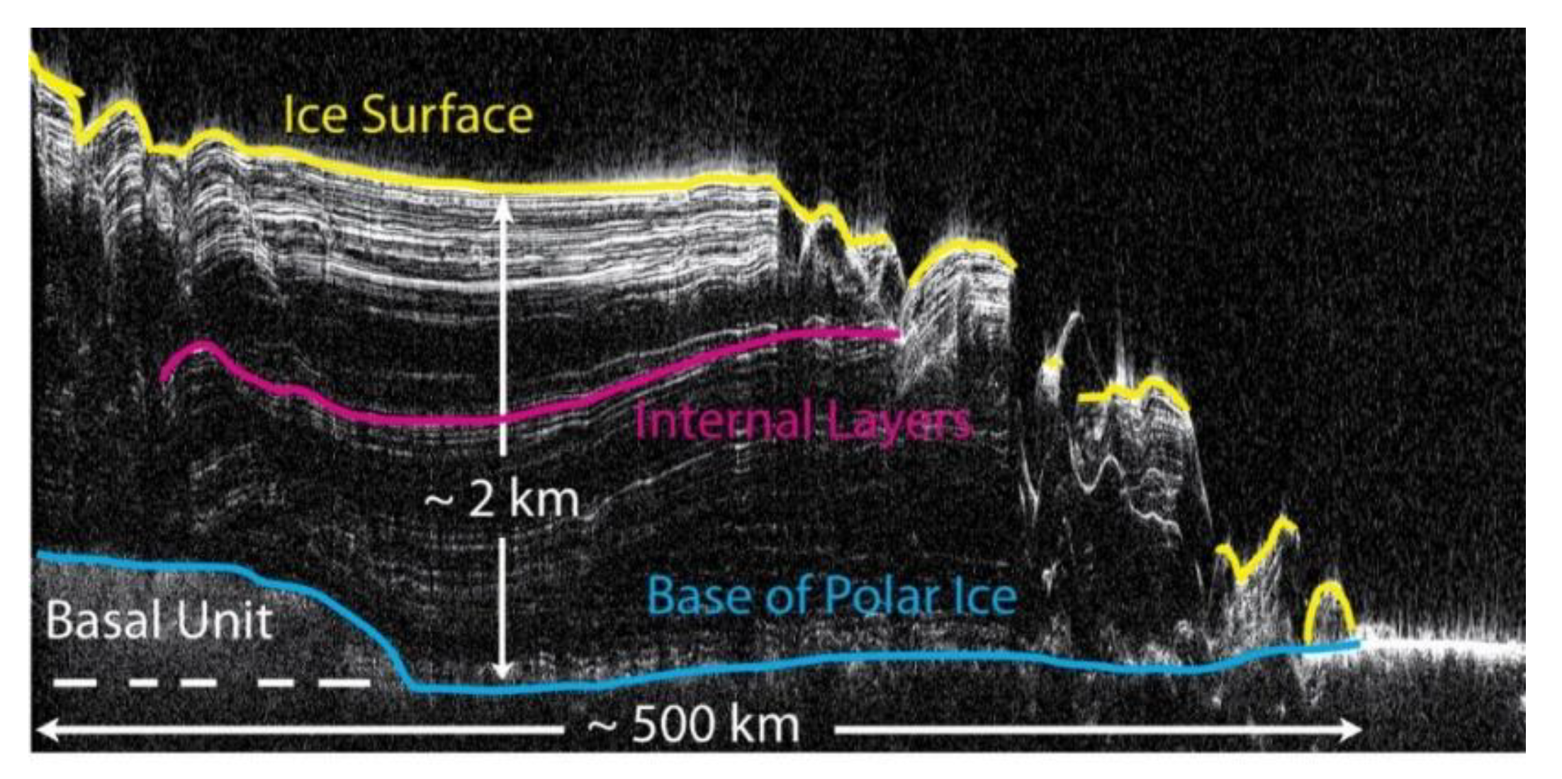
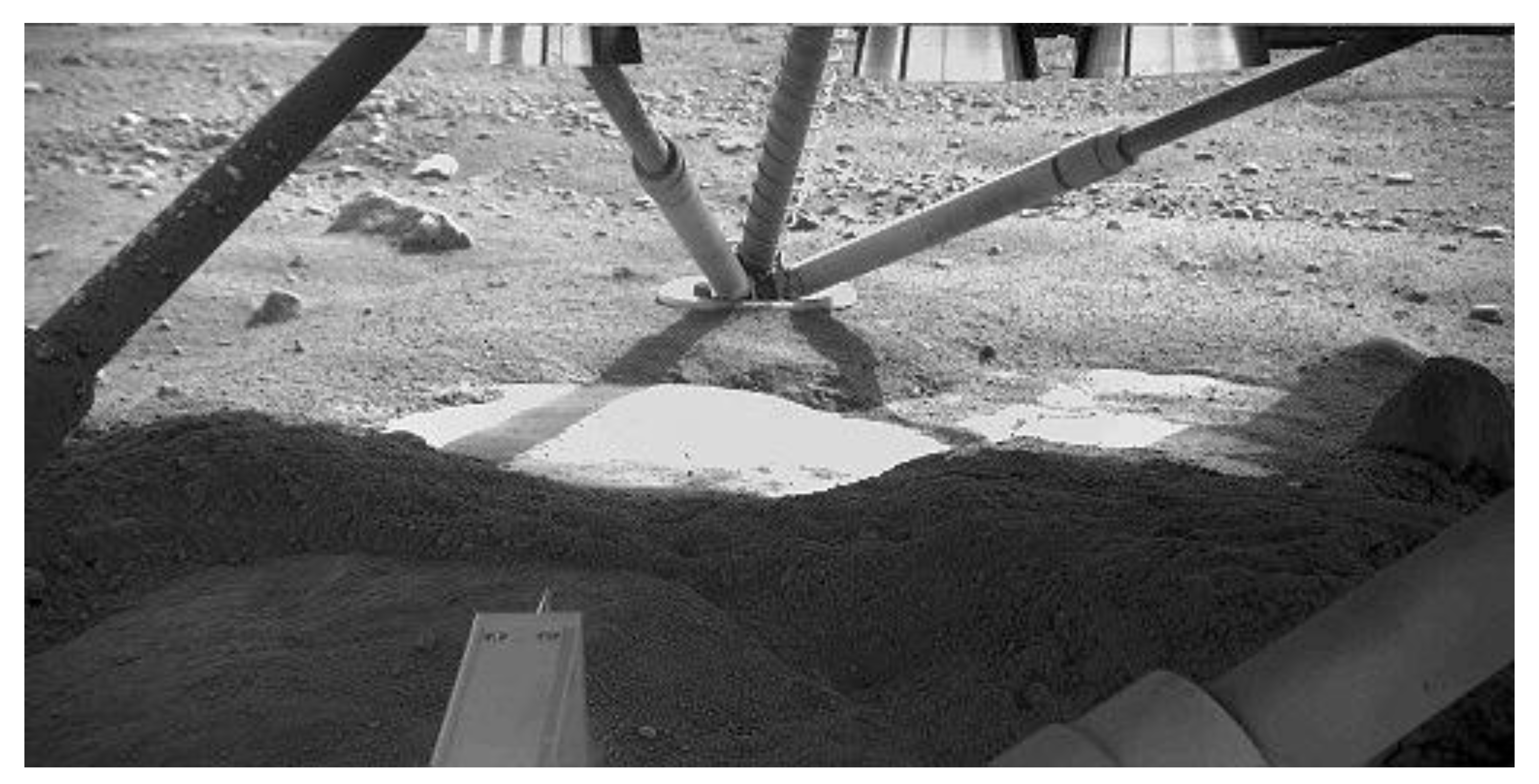
© 2020 by the authors. Licensee MDPI, Basel, Switzerland. This article is an open access article distributed under the terms and conditions of the Creative Commons Attribution (CC BY) license (http://creativecommons.org/licenses/by/4.0/).
Share and Cite
MDPI and ACS Style
Nazari-Sharabian, M.; Aghababaei, M.; Karakouzian, M.; Karami, M. Water on Mars—A Literature Review. Galaxies 2020, 8, 40. https://doi.org/10.3390/galaxies8020040
AMA Style
Nazari-Sharabian M, Aghababaei M, Karakouzian M, Karami M. Water on Mars—A Literature Review. Galaxies. 2020; 8(2):40. https://doi.org/10.3390/galaxies8020040
Chicago/Turabian StyleNazari-Sharabian, Mohammad, Mohammad Aghababaei, Moses Karakouzian, and Mehrdad Karami. 2020. "Water on Mars—A Literature Review" Galaxies 8, no. 2: 40. https://doi.org/10.3390/galaxies8020040
Note that from the first issue of 2016, this journal uses article numbers instead of page numbers. See further details here.