
Lifecycle Applications of Building Information Modeling for Transportation Infrastructure Projects

Department of Civil Engineering Technology Environmental Management and Safety, Rochester Institute of Technology, Rochester, NY 14623, USA
*
Author to whom correspondence should be addressed.
Buildings 2023, 13(9), 2300; https://doi.org/10.3390/buildings13092300
Submission received: 31 July 2023
/
Revised: 28 August 2023
/
Accepted: 8 September 2023
/
Published: 9 September 2023
(This article belongs to the Section Construction Management, and Computers & Digitization)
Abstract
:Infrastructure plays a pivotal role in a nation’s economic stability, security, and long-term sustainability. For decades, United States infrastructure has been rated as inadequate and the resources required for its restoration continue to grow. Despite the transformative potential of Building Information Modeling (BIM) coupled with digital technologies in revolutionizing the building industry, its widespread adoption within infrastructure projects remains limited. This study explores the application of BIM and emerging technologies in transportation projects’ lifecycle, identifies research gaps, and discusses the use of technology to address current infrastructure challenges. Employing a systematic review approach, this research synthesizes BIM application studies based on well-defined criteria. The synthesis of the literature underscores the comprehensive integration of BIM throughout the lifecycle of transportation assets, catalyzed by collaborative, information-driven processes. However, challenges pertaining to interoperability, role delineation, standards enforcement, and cost persist. This study advocates for a deeper exploration of the synergy between BIM, digital technologies, and infrastructure, envisioning an enriched transportation lifecycle in the future.
1. Introduction
Infrastructure plays a critical role in connecting a nation’s businesses, communities, and people [1]. It supports nearly every aspect of life and is pivotal to a nation’s economic stability, security, and long-term sustainability [2,3,4,5]. For example, ports, railroads, and highway systems allow for the efficient transportation of goods, people, and services. Transmission and distribution lines provide electricity to power buildings. Water distribution systems deliver fresh drinking water. Without these infrastructure systems, life would be drastically different.
Roads and highways in the United States move nearly USD 17 trillion of goods yearly [1]. They also serve as a means to transport people to their destinations daily. However, the roads and highways in the United States are plagued by poor conditions that cause excessive wear and tear on vehicles and lead to accidents that result in injury or fatality [1]. For example, roads that are in poor condition may contain potholes, rutting, or rough surfaces that induce stress on vehicle components resulting in accelerated vehicle depreciation, increased fuel consumption, and increased tire wear [6]. A National Transportation Research Nonprofit (TRIP) estimates that Americans spend nearly USD 130 billion annually on vehicle repairs and operating costs caused by poor road conditions [6].
Furthermore, congestion is an increasing problem as vehicular traffic volumes increase, but the network of roads and highways remains relatively constant. During peak hours, 47% of the nation’s interstates experience congestion [7] and 30% of trips taken on all roads are impacted by severe or extreme congestion [8]. Congestion causes individuals to spend extra time commuting, resulting in their vehicles consuming more fuel. According to the American Society of Civil Engineers (ASCE) Infrastructure Report Card, congestion problems cost US commuters USD 166 billion yearly in wasted time and fuel [1]. Repairing, reconstructing, and adding new roads and highways to the existing network can make the transportation of goods and people safer and more efficient, saving people time and money.
In the United States, there are over 617,000 bridges [1], 45,000 of which are considered structurally deficient [9]. According to the Federal Highway Administration (FHWA), bridges are considered structurally deficient when one or more of their components (deck, superstructure, substructure, or culverts) are rated in poor condition [1]. Americans take 178 million trips across structurally deficient bridges daily [10], compromising their safety. As these bridges deteriorate, they may be posted for weight or speed restrictions or closed altogether [1]. When bridges are posted for weight or speed restrictions, large vehicles such as buses, delivery trucks, ambulances, and fire trucks may need to find alternative routes. This slows response times and may impede rescue efforts [1]. Closed bridges impact all vehicular movement since they require alternate routes resulting in increased trip lengths and higher fuel consumption. In order to protect the public’s safety and ensure adequate, efficient access for vehicles, there is a clear need to improve the conditions of the deteriorating bridges in the United States.
According to the 2021 Report Card, US infrastructure scored an overall grade of C−, meaning they are “mediocre” and “require attention”, and the total infrastructure funding gap based on current trends is USD 2.588 trillion [1]. There is a clear need for more efficient and cost-effective tools and techniques to enhance infrastructure and close the funding gap. In order to better utilize the limited available funding, ASCE recommends leveraging proven and emerging technology and integrating and utilizing big data and the internet of things (IoT) throughout the entire lifecycle of an infrastructure to streamline asset management and implement lifecycle cost analysis into routine planning processes [1]. Building Information Modeling (BIM) is a possible solution to address this need [11].
Traditional design and construction processes are fragmented and depend on manual, paper-based communication methods [12]. For example, architects and engineers drafted construction drawings and provided two-dimensional plans which consisted of plan views, section views, and elevations for contractors to build the project [13]. Errors and omissions were common in the design, because any time one view was modified, all other views had to be manually checked and updated [13]. Furthermore, paper-based design methods often result in conflicts [12]. For example, ductwork and pipes clashed during installation due to drawing errors. These errors and omissions cause rework, unanticipated costs, delays, and disputes during construction, sometimes resulting in lawsuits between parties in a project team [12]. As technology advanced, the design process began shifting to digital formats. Three-dimensional (3D) modeling was introduced in the early 1970s, allowing designers to parametrically model their designs [14]. This resulted in fewer conflicts than relying solely on two-dimensional designs [12]. Although digitizing the design process decreased the time required to complete the design [13] and improved the timely exchange of information [12], it was still plagued by errors, omissions, and conflicts. With additional advancements in technology and software applications, BIM was introduced as a concept in the early 2000s [12,13]. BIM added a layer to three-dimensional parametric modeling that allows for the input of all information related to the physical and functional characteristics of a building component [13]. For example, a drainage utility hole can be modeled with its physical dimensions as well as information about its supplier, operation and maintenance procedures, flow rates, and clearance requirements [15]. Additionally, BIM uses “smart objects”, so that when a design is updated in one view, all corresponding views are automatically updated, eliminating many of the errors and omissions associated with traditional modeling techniques [12].
BIM has been used in the building industry for decades [4,16,17], and the industry has experienced improvements in cost [18,19,20], productivity [13], accuracy [14], communication [12], and efficiency [20,21] as a result. However, despite the proven benefits experienced by the building industry, BIM has not yet gained widespread adoption in infrastructure construction projects [4,17,22,23,24]. The established methods and rapid advancements in BIM and emerging technology offer promising opportunities to improve the efficiency and effectiveness of the construction process for infrastructure projects [25,26].
Most existing literature on the use of BIM for infrastructure construction projects focuses on a specific BIM use or the application of multiple BIM uses within a specific project phase. However, very few studies comprehensively review multiple BIM uses across the entire project lifecycle. Therefore, this paper aims to provide a systematic review and critical analysis of various BIM uses across the entire project lifecycle to support the repair, advancement, expansion, and maintenance of transportation infrastructure. The objectives are to collect and analyze publications relevant to the use of BIM on transportation infrastructure projects, discuss BIM uses and applications for each lifecycle phase, highlight emerging technologies that support BIM, and discuss how BIM and the supporting technology can be used to address current needs for transportation infrastructure improvements. Gaps in the use of BIM to support infrastructure improvements are discussed, and recommendations for future research are explained. This study contributes to the field by illustrating how BIM can benefit transportation infrastructure projects throughout their lifecycle. Specifically, it provides a benchmark of current BIM uses in the transportation infrastructure sector, highlights trends, and offers suggestions to facilitate future research and applications that aid in improving transportation infrastructure. Furthermore, this study serves as a valuable reference point for enhancing the knowledge of policy makers and practitioners and assisting them in planning and funding efforts regarding the use of BIM in infrastructure projects.
This paper is organized into eight sections. In Section 2, the key terms and concepts are defined and the scope of the paper is discussed. In Section 3, the research methodology is described in detail, including how relevant publications were identified, screened, and selected for inclusion in this study. In Section 4, the findings are presented, including the uses of BIM for transportation infrastructure, while Section 5 provides an analysis of emerging trends and technologies, Section 6 discusses the research gaps, challenges, and potential of BIM for infrastructure projects, Section 7 presents the limitations of the study, and Section 8 includes concluding remarks and recommendations for future research.
2. Key Terms, Concepts, and Scope of Study
2.1. Infrastructure
Infrastructure has been defined by many national agencies, states, municipalities, and professional and trade organizations, each adding its own sector-specific biases. For example, Fulmer defined infrastructure as “the essential facilities and services that the economic productivity of a community or organization depends on” [27]. Chambers’ definition of infrastructure includes examples of the facilities and services Fulmer described. In Chambers’ words, infrastructure is “the physical structures, facilities, and networks that provide essential services to the public,” including “transportation structures (roads, bridges, tunnels, railways, airports, and seaports), energy and utility companies, communication entities, and social services such as education facilities and hospitals” [28]. ASCE goes one step further, defining infrastructure as the “complex and interrelated physical, social, ecological, economic, and technological systems” that support human activities [29]. Regardless of the definition, infrastructure is a broad term that describes the structures, facilities, and systems that support daily human activity and the economy.
Infrastructure can be categorized based on function. The major infrastructure domains include transportation, energy, utility, recreational facilities, and water management [4,16]. Every four years, the American Society of Civil Engineers (ASCE) publishes a comprehensive assessment of the nation’s infrastructure, the ASCE’s Report Card for America’s Infrastructure. The ASCE Committee on America’s Infrastructure that performed the 2021 infrastructure assessment comprised 32 civil engineers [1]. The committee examines current infrastructure conditions and needs, consults with technical and industry experts, assigns grades to each infrastructure category, and makes recommendations for future improvement.
When assessing the state of infrastructure in the US, the ASCE assigns grades using the following criteria [1]:
- Capacity—the infrastructure’s ability to meet current and future needs;
- Condition—the current and near-future physical condition of the infrastructure;
- Funding—the current amount of approved funding from all sources compared to the estimated funding needed to adequately maintain the infrastructure;
- Future need—estimated cost to improve the infrastructure to an adequate or better condition;
- Operation and maintenance—the ability of the owner to operate and maintain the infrastructure properly and to keep the infrastructure in compliance with regulations;
- Public safety—the extent to which the public’s safety will be jeopardized in the case that the infrastructure fails;
- Resilience—the infrastructure’s ability to withstand threats and incidents such as extreme weather and climate-rated disasters and the infrastructure’s ability to recover with minimum consequences for public safety and health, the economy, and national security in the case that the infrastructure cannot withstand an extreme weather event or climate-related disaster;
- Innovation—new techniques, materials, technologies, and delivery methods that are being implemented to improve the infrastructure.
The ASCE Committee considers these key criteria when assessing relevant data and reports and consults with technical and industry experts to assign grades to US infrastructure. Grades range from A to F, where A represents the best possible condition (exceptional, fit for the future) and F represents infrastructure that is failing and unsafe (failing/critical, unfit for purpose) [1].
US infrastructure systems continue to be inadequate, according to ASCE’s assessments. They are aging, deteriorating, underperforming, and struggling to keep up with the increasing capacity demands of the growing population [1]. Furthermore, they are susceptible to extreme weather and climate-rated disaster events [9]. The grades assigned to each infrastructure category and overall grades dating back to 1998, the first year ASCE released the infrastructure report card are provided in the 2021 ASCE infrastructure report card [1]. The only infrastructure categories to receive adequate grades (B− or better) were ports (2021), rail (2017 and 2021), and solid waste (2013). All other categories have consistently earned inadequate grades for the past two decades. Even those categories that improved over this period only did so incrementally. The most recent report card that ASCE published in 2021 rated the overall condition of US infrastructure with a grade of C−, up from the D+ grade received in the 2017 report. While the condition of infrastructure has improved over the past four years, ASCE deemed that the overall condition of America’s infrastructure is on the low end of mediocre. Therefore, there is still a need for future improvement.
The scope of this study is limited to the transportation infrastructure domain. Specifically, this study focuses on horizontal transportation infrastructure, mainly bridges, roads and highways, railways, and tunnels. Ports, docks, harbors, airports, and mass transit were excluded from the study because their structures are typically vertical and, therefore, are viewed as similar to buildings for this study. This is not to say, however, that the excluded categories would not benefit from adopting BIM tools.
2.2. BIM
The National Building Information Model Standard Project Committee [30] defines BIM as follows: “Building Information Modeling (BIM) is a digital representation of physical and functional characteristics of a facility. A BIM is a shared knowledge resource for information about a facility forming a reliable basis for decisions during its life cycle; defined as existing from earliest conception to demolition.” BIM is both a technology and a process. It incorporates traditional three-dimensional computer-aided design (CAD) and all pertinent information and properties of a building’s components, such as design plans, product information, schedule sequencing, and operations [4]. From a technology perspective, BIM is a three-dimensional model and collection of databases and information exchanges containing all the required information to plan, design, construct, and operate the structure [31]. In terms of a process, BIM utilizes workflows and project delivery processes that are more collaborative than traditional methods [21]. These workflows are based on information sharing throughout all phases of a project.
Horizontal and vertical construction are terms used in the design and construction industry to describe the physical orientation of built structures. Vertical construction refers to structures whose footprint is confined relative to their height. High-rise office buildings, hospitals, and schools are all examples of vertical construction. Horizontal construction refers to structures whose footprint is more spread out relative to their height. Roads, bridges, railways, and tunnels are all examples of horizontal construction [4]. BIM has most often been used for vertical construction projects [4]. As such, many of the modeling tools and techniques are specific to the means, methods, and components of vertical construction. Although BIM has been predominantly used for vertical construction projects, horizontal construction projects have deployed digital design, modeling, development, and information tools similar to BIM. These include bridge information modeling (BrIM), civil information modeling (CiM), transportation information modeling (TIM), and virtual design and construction (VDC).
BIM technology is flexible enough to be used in many ways to meet the needs of various owners and achieve project goals. A BIM use is a task, outcome, or deliverable that a BIM model is used to achieve. Kreider and Messner [32] define a BIM use as “a method of applying BIM during a facility’s lifecycle to achieve one or more specific objectives.” BIM uses provide valuable data sets throughout a project that assist owners and decision-makers in planning, designing, constructing, and operating the project. BIM requirements are developed based on the owner’s project requirements and goals [33]. Therefore, BIM uses cover all stages of a project lifecycle from concept through operation and maintenance [20]. Figure 1 is adapted from Messner et al. [34] and illustrates how BIM uses have been applied to vertical construction.
As illustrated, BIM uses may apply to a single project phase or multiple project phases. For example, the cost estimation BIM use is employed across all four project lifecycle phases, while the asset management BIM use applies only to the project operations phase. The project lifecycle is the same for vertical and horizontal construction. Therefore, the illustrated BIM uses apply in the same way to horizontal construction.
2.3. Lifecycle Analysis of BIM Uses for Transportation Infrastructure
The phases in a typical infrastructure project lifecycle are planning, design, construction, and operations. Each construction project begins with the planning phase, where conceptual planning and feasibility studies are performed. During the planning phase, project goals and needs are defined, risks are identified and prioritized, funding requirements are identified, and design alternatives and delivery methods are considered. If the project is deemed feasible and funding is available, it moves into the design phase where a design team creates design documents that incorporate the owner’s requirements, standards, and criteria, as well as pertinent codes. The design phase is divided into three stages: schematic design, design development, and construction documents [35]. In the schematic design phase, the project program is translated into a high-level design of the structure. This design considers the physical requirements and relationships of the structure and its components. In design development, the high-level schematic design is further refined and expanded into a final design that incorporates all the details and specifications required for construction. As design shifts to the construction documents stage, the focus shifts to communicating the design and providing all information necessary to construct the project through construction drawings and specifications. Construction documents serve as the basis of bid documents and construction contracts. When the design is complete, construction commences. During the construction phase, contractors and materials are procured, and the project is constructed according to the construction documents. After construction, the project is turned over to the owner, and the operations phase begins. This phase includes the day-to-day activities necessary for the structure to perform its intended functions. Examples of activities in this project phase include asset management, disaster planning, preventive, predictive, and corrective maintenance, renovations, and inspections.
BIM can be applied across the entire lifecycle of infrastructure projects to assist decision-makers and other key stakeholders [36]. Figure 1 illustrates common BIM uses used in the building industry and the lifecycle phase(s) in which they may be used. Some BIM uses may be applied iteratively in multiple lifecycle phases as additional details are incorporated into the design. Other BIM uses may apply to a single lifecycle phase. The following sections discuss lifecycle analysis of BIM uses for transportation infrastructure projects in more detail.
3. Research Methodology
3.1. Research Approach
This study was conducted using a systematic review approach to collect and analyze relevant data while minimizing bias. A systematic review uses explicit, systematic methods to collate and synthesize the findings of studies that address a clearly formulated question [37]. They minimize researcher bias by documenting the predetermined, clear set of criteria that are used to focus and limit the research. This study utilized the Preferred Reporting Items for Systematic Reviews and Meta-Analyses (PRISMA) method to identify, select, appraise, and synthesize studies based on the documented predetermined criteria [38]. PRISMA is characterized by a four-phase flow diagram and a 27-item checklist that ensure the transparent and complete reporting of systematic reviews [38].
The procedure began with an initial exploration of the existing literature to define the scope of the study. To achieve this, a preliminary search was performed to briefly review published papers on the topic to determine what is known from the existing literature about the application of BIM in transportation infrastructure projects. Through this process, the scope of the study was defined. Next, the list of databases that were to be used to query for relevant publications was defined and a detailed search of the databases was conducted using predefined keywords, phrases, and Boolean logic. The predefined keywords were modified after the initial search to broaden the number of publications available for analysis and the detailed search of databases was repeated with the revised keywords. Three databases were selected for this review: Elsevier-Science Direct, MDPI, and Google Scholar. These three databases were selected for their breadth and depth of topics in engineering, construction, and technology, including peer-reviewed articles, and availability of open access publications to aid retrieval. They also have a global reach, provide comprehensive coverage, and include diverse sources. In addition to the publications identified through database searches, supplementary publications from government agencies, professional organizations, industry publications, and conference proceedings were included through snowballing from the identified articles.
Following this step, the publications were screened for inclusion in the study based on predetermined selection criteria using the PRISMA framework. Finally, the eligible publications were analyzed in depth to support the research objectives.
3.2. Keywords
BIM has been widely adopted by professionals who design and construct vertical construction projects (i.e., buildings). However, BIM has only recently gained traction for horizontal construction projects (i.e., infrastructure, transit, and utilities). Therefore, additional keywords were included to broaden the search results and ensure publications related to BIM or similarly related technology for infrastructure projects were included. These additional keywords included Civil Information Modeling (CiM), Virtual Design and Construction (VDC), Bridge Information Modeling (BrIM), and Transportation Information Modeling (TIM). The definitions of these keywords are synonymous with BIM, but are much more widely used by professionals who design and construct civil and transportation-related projects.
Each database was queried using predefined keywords and phrases to identify potentially relevant publications. The following keyword phrases were used in this study:
- (1)
- [(BIM OR “Building Information Modeling”) AND Transportation]
- (2)
- [(CiM OR “Civil Information Modeling”) AND Infrastructure]
- (3)
- [(VDC OR “Virtual Design and Construction”) AND Infrastructure]
- (4)
- [(BrIM OR “Bridge Information Modeling”) AND Infrastructure]
- (5)
- [(TIM OR “Transportation Information Modeling”) AND Infrastructure]
- (6)
- “Infrastructure Information Modeling”
All keywords were used to search within the titles, keywords, and abstracts of potential publications.
3.3. Selection Criteria
Various selection criteria were used to limit and focus the total number of eligible publications. The criteria included using review and research articles that were published in English with online open access. The results were further refined based on the year of publication. A survey by [39] measured the growth of BIM implementation for transportation infrastructure projects in the United States, United Kingdom, France, and Germany. The survey results show that the percentage of engineers and contractors who used BIM on half or more of their transportation infrastructure projects surged in all four countries between 2015 and 2017. The survey also found that this upward trend was expected to continue in 2019 and beyond. These findings were substantiated by [40], whose research showed that the use of BIM for infrastructure projects experienced a sudden increase in 2016. Based on these statistics, search results were limited to studies published between January 2015 and February 2022.
A search of the keywords and application of selection criteria filters across each of the three databases resulted in a total of 637 publications. In addition, 22 duplicate publications were removed, resulting in 615 unique publications. Duplicate publications existed due to the synonymous nature of the keywords and common publications across the databases that were used. The PRISMA flow diagram in Figure 2 illustrates the number of publications excluded at each screening step as well as the reasons for their exclusion.
Following the identification, 615 unique publications were screened to further refine the list of eligible publications. First, the titles and abstracts were screened to determine whether the publication’s content was relevant to the proposed study. Keywords such as transportation, bridge, highway, road, rail, tunnel, and metro were searched for in the title and abstract of publications. Publications without these keywords in their title or abstract were assumed to be building-related and were excluded. Next, the title and abstract were reviewed in detail to determine if the publication was relevant to the study. Publications were excluded for one of three reasons: (1) the content was deemed to be building-related, (2) the content was not BIM-related, or (3) the content was not related to transportation infrastructure. After screening, a total of 57 publications remained for detailed analysis, and 14 supplementary articles were added.
3.4. Data Analysis
At the initial search, the studies included in the review comprised a diverse range of sources, including 59% of research papers, 21% review articles and 20% supplementary publications. Of the 14 supplementary sources, four articles were from government agencies, three were from professional organizations, two were industry publications, and five were conference proceedings. Review articles served as secondary sources for the analysis.
For a more nuanced analysis, the publications were evaluated based on their publication year. An analysis of the publications included in the review by the year in which they were published showed an upward trend each year from 2015 to 2021 with increasing number of publications related to BIM for transportation projects (Figure 3). It is important to note that the database searches occurred in early February 2022, therefore, the publications included for 2022 are limited to those published in the first two months of 2022 only. It is expected that the number of publications for 2022 would be significantly higher if the database searches were performed later in the year. Additionally, the majority of articles included in this review were published in the journal Automation in Construction.
The articles identified using the keywords were broken down based on the infrastructure category they focus on. Bridges were the most frequently discussed, comprising 24 articles, with 14 articles focused on roads, 13 focused on rail, and tunnels included in 9 articles. A number of publications included content related to multiple categories within the transportation infrastructure domain.
4. BIM Uses for Infrastructure Projects
The literature shows many ways that BIM can be used to improve efficiency in the construction industry. These uses span the lifecycle of a project. Wang et al. [25] developed a comprehensive list of BIM uses for bridge, road, and aviation infrastructure projects after reviewing actual applications in fifteen case studies. Similarly, Kim et al. [22] identified five BIM uses that were applied to infrastructure projects in the design phase and five BIM uses that were applied in the construction phase. The use of BIM was limited to the design and construction phases of the case studies that were reviewed. Table 1 illustrates the BIM uses in the reviewed literature and the project lifecycle phase(s) in which they were applied by identifying keywords in the articles related to each of the BIM uses. These are further explained in the following sections.

Table 1.
BIM Uses at various Project Phases.
| BIM Uses | Plan | Design | Construct | Operate |
|---|---|---|---|---|
| Asset Management | [5,23,41,42,43,44] | |||
| 3D Coordination | [17,24] | |||
| Code Validation | [17,20] | |||
| Cost Estimation (5D) | [17,20,45] | [24] | ||
| Design Review | [17,46] | [20,24,47,48] | ||
| Emergency Management | [49] | [50,51] | ||
| Engineering Analysis | [17,20,52,53,54] | [54] | ||
| Existing Conditions Modeling | [24] | [17] | [41,54] | |
| Record Modeling | [55,56,57] | [44] | ||
| Phase Planning (4D) | [24] | [58] | [59,60] |
4.1. Asset Management
Asset management is a process in which a record model and management system are linked to aid in the operation and maintenance of built assets. Asset management use was prevalent in the literature. For example, Pregnolato [42] discussed the need for a bridge maintenance system to collect and inventory bridge data in a systematic and organized way. Moreno Bazan et al. [23] highlighted the benefits of a bridge management system (BMS) using BIM. The benefits included an efficient management and maintenance system for bridges allowing decision-makers to proactively plan and appropriately fund maintenance actions. The BMS provided a planned schedule for future payments associated with maintenance activities, improved traffic safety, and extended the life expectancy of the asset as a result. Dong et al. [41] implemented a management system for roadways that included 3D as-built model information and used it to identify, prioritize, and budget future maintenance needs. Isailovic et al. [44] incorporated damage information, such as spalling and cracking, from inspection findings into the as-built model of a bridge. In doing so, the model was updated to reflect the current condition of the bridge more accurately, providing a foundation for scheduling needed maintenance. Ding et al. [43] developed an equipment maintenance strategy for metro equipment. The authors used BIM as an object-oriented database to store topological relations of equipment, express the equipment maintenance plane, and form a maintenance information storage and data analysis platform. When applied to a case study, the proposed maintenance strategy developed using BIM resulted in improved reliability and reduced maintenance costs. Aziz et al. [5] leveraged BIM and big data analysis to manage highway infrastructure assets to reduce the lifecycle costs of highways through real-time asset monitoring. More recently, Hagedorn et al. [61] developed a BIM-enabled infrastructure asset management system that can query data from different information models to support stakeholders decision-making during the operations and maintenance phase. The authors emphasized the importance of BIM model development in the design and construction phases to support asset management after handover.
4.2. 3D Coordination
Three-dimensional (3D) coordination is a process where the 3D model is processed with clash detection software to identify spatial conflicts between different components within the design with the goal of eliminating all conflicts before the components are built in place [32]. Three-dimensional coordination prevents rework, reduces change orders and RFIs, and increases productivity, resulting in more efficient project schedules and lower overall costs in construction projects [62]. For example, Sankaran et al. [24] used 3D models during the design phase to identify and resolve spatial conflicts such as roadways, drainage, utilities, and other structures. As a result, there were fewer change orders and design issues when the asset was being constructed. Castenada et al. [17] used BIM to perform 3D coordination and clash detection processes for the design of a road and intersection reconstruction project. The project stakeholders, who were interviewed after the project was complete, stated that the project was improved due to the 3D coordination process, which reduced rework on the project, ultimately leading to reduced construction costs and a more efficient project schedule.
4.3. Code Validation
Code validation is a process where the model is used to automatically validate project-specific codes through the use of code validation software [32]. This BIM use results in a more efficient design process by preventing errors, omissions, and oversights that result in costly and time-consuming changes later in design or construction [32]. Code validation was not heavily used in the publications that were included in this study, showing up in just two publications. Catenada et al. [17] used code validation to confirm that the design of a road and intersection project met all applicable code requirements. Vignali et al. [20] used the “Country Kit” tool to dynamically check the road design against current code requirements and correct code deficiencies where present. The tool provided continuous feedback on code compliance as design changes were made.
4.4. Cost Estimation (5D Modeling)
Cost estimation or 5D modeling is a process of generating quantity take-offs to develop an estimated cost of constructing a project. BIM assists with cost estimation processes because it can efficiently generate accurate quantity take-offs using the model [34]. Furthermore, BIM extends traditional, manual-based cost-estimating techniques by allowing the project team to quickly see and assess the cost impact of a design change, helping curb budget overruns [34]. Cost estimation is most beneficial when used in the early stages of a project because changes have less impact on the overall project cost [34]. Although Barakchi et al. [63] initially reported that BIM-based cost estimation methods had not received a lot of attention, the use of BIM for cost estimation during the design phase showed up in more recent publications. Castenada et al. [17] used BIM to conduct quantity take-offs for four design alternatives. The quantity take-offs were used to estimate the cost of each alternative to present to the project owner to assist them in deciding which design to select. Vignali et al. [20] used a 3D model created using BIM software to calculate volumes and quantities of material used in the design of a new roundabout to estimate the cost of the project. The authors found that the chosen software, Autodesk AutoCAD Civil 3D, did not allow quantity takeoff data to be exported in Industry Foundation Class (IFC) format, so a plugin was created that allowed for the data to be converted to an IFC readable format for use in estimating costs using the “STR Vision CPM” software program. Vitasek and Matejka [45] used BIM to automate quantity takeoffs for estimating the costs of road infrastructure projects in the Czech Republic. Based on two case studies, the authors concluded that BIM models currently used in the Czech Republic do not contain the necessary information for accurate quantity takeoffs, resulting in inaccurate cost estimates. The authors recommend that quantity takeoff requirements are specified and standardized in the Czech construction industry. Bae et al. [48] used BIM to compare the as-built surface profile of a concrete slab base in a tunnel with the design surface profile to identify the differences to optimize the design of the hot mix asphalt layer of the tunnel’s driving surface. In doing so, the design team was able to optimize both the amount of milling required to level the concrete slab base as well as the quantity of hot mix asphalt (HMA) required. Using BIM in this manner resulted in a higher quality product with an approximately 12% reduction in costs realized by spending less time milling combined with using an optimal amount of HMA. Sankaran et al. [24] used cost estimation during construction to monitor project progress and estimate contractor costs.
4.5. Design Review
Design review is a process in which project stakeholders view a 3D geometric model to validate design aspects and constraints prior to constructing the asset [34]. During a design review, stakeholders are able to visualize design options virtually in 3D using computer or immersive, virtual reality environments. By doing so, stakeholders gain a better understanding of the end product [64]. Castaneda et al. [17] used BIM during the planning phase to conduct a design review of four alternative intersection designs. According to project participants, who were interviewed after the project, the design review gave them a better understanding of the proposed designs in the early stages of planning, allowing them to express their opinions and make changes to the design. The stakeholders perceived that the design review led to fewer changes in design and construction, resulting in a faster design process and reduced construction duration and costs. Love et al. [46] leveraged design reviews during the planning phase of rail projects to allow stakeholders to visualize the rail asset in 3D and make critiques and modifications. By modifying the design in the planning phase, the design review process mitigated scope changes later in the project, reducing the overall project cost. Vignali et al. [20] used a 3D model of a road, tunnel, and rail line modernization project to present the proposed design to stakeholders during the planning and design phases, allowing them to visualize how the structures were integrated into the existing environment. Sankaran et al. [24] developed 3D models of various public works projects to present to the public throughout the design process. Cantisani et al. [47] utilized BIM to analyze the redesign of a high-volume road intersection to improve traffic capacity and level of service and reduce traffic delays and the extra emissions that result from the queued vehicles. Four different scenarios were investigated using BIM. Each design scenario was simulated and analyzed from the perspectives of operation performance, carbon footprint, and construction, maintenance, and usage costs. Additionally, the geometry, environmental impacts, and traffic analysis were considered to implement a benefit–cost analysis, allowing decision-makers to optimize and validate the design alternatives using predetermined criteria.
4.6. Engineering Analysis
Engineering analysis is a process in which modeling software is used to analyze and simulate performance to determine the most effective engineering method based on design specifications [32]. This paper considered engineering analysis, including structural analysis, traffic flow analysis, and tunnel engineering. Engineering analysis using BIM automates the analysis process, reducing design duration and saving time and cost [32]. Engineering analysis was used exclusively in the design phase in the literature. Vignali et al. [20] used “Revit Structure” to perform the structural analysis of rail line bridge and tunnel components. Tang et al. [52] used “Revit” and “Civil 3D” to model the Beijing–Shanghai expressway. Model data were converted to Finite Element Modeling (FEM) software ABAQUS to perform structural calculations and analysis of the asphalt pavement. Tang et al. [65] used Dyanmo to create a 3D geometrical model of pavement for structural analysis purposes. Korus et al. [53] used Dynamo to model arch bridges and conduct strength analysis within one parametric environment, minimizing material consumption and cost while continuing to meet strength requirements. Koch et al. [66] developed a tunnel information modeling (TIM) framework that consisted of four linked sub-models: ground model, boring machine model, tunnel lining model, and built environment model. The TIM was used during construction to visualize time-dependent settlement monitoring data and compare them to predicted settlements for a metro tunneling project in Dusseldorf, Germany. Castenada et al. [17] used BIM for structural analysis and traffic analysis and simulation to automate documentation and feedback of traffic analysis-related processes during design. After the project was completed, project participants were interviewed about the benefits of using BIM. The results showed that project participants perceived a more efficient design process that resulted in increased quality and lower construction costs as a result of using BIM for engineering analysis.
4.7. Emergency Management
Emergency management, also known as disaster planning, is a process where a model is used to provide emergency responders with critical information to improve the efficiency and effectiveness of the response and minimize risks to the first responders [32]. Tang et al. [50] performed emergency management by extracting asset information from the BIM model of a metro station. The information was used in conjunction with disaster simulation software to develop a decision-making framework to assist designers with emergency evacuation risk mitigation in their designs. Luo et al. [51] used BIM to provide realistic visualization of the emergency plan for better understanding and to support efficient emergency plan training processes for staff. Lin et al. [49] used BIM as a tool to prevent emergency situations during tunnel construction. The approach helped manage the risks associated with deep excavations by integrating risk assessment methods into the BIM management platform. The authors were able to create a safety risk prediction model that provided early warning signs of ground settlement during tunnel excavation. Using BIM in this manner helped prevent excavation collapses, reducing the chance of damage caused by collapse and minimizing environmental effects.
4.8. Existing Conditions Modeling
Existing conditions modeling is a process that involves collecting data points through the use of surveying or scanning techniques to develop a 3D geometric model of the existing conditions at a potential project site for analysis [34,41]. Existing conditions may include raw land for new construction or an existing asset for modernization. As illustrated in Table 1, existing conditions modeling has been used in the planning, design, and operations and maintenance phases of infrastructure projects. For example, Sankaran et al. [24] modeled existing conditions in the planning phase of four different infrastructure projects: a rotary upgrade, a roadway relocation, reconstruction of an interchange, and a bridge replacement. The authors used surveying equipment and advanced laser sensing technologies to rapidly collect data and georeferenced it to produce 3D point clouds which were converted into existing conditions models that were used for project planning purposes. Dong et al. [41] developed a pavement management system for road maintenance, they collected pavement data using IoT technology (such as sensors) and GPS data converted using 3D laser point cloud technology. Cantaneda et al. [17] used BIM during the design phase to model existing conditions of a road intersection in Columbia. The existing conditions model served as the foundation for other models that were developed in the design and construction phases. Soilan et al. [54] developed an automated methodology to model railway alignment using LiDAR to scan a 90 km long existing railway and extract the rails from a 3D point cloud for use in creating a 3D geometric model. The automated method proved to be significantly more efficient than a manual delineation and shows potential for use in other horizontal construction such as highways.
4.9. As-Built (Record) Modeling
As-built modeling is the process of compiling an accurate representation of the built asset to hand over to the asset owner [32]. As-built models are important to owners because they assist with future project alterations, renovations, and operation and maintenance activities. Record modeling appeared for only tunnel projects in the literature. Duan et al. [55] concluded that as-designed BIMs have little value during the operation and maintenance phase of tunnel projects because the snakelike motion of the tunneling machine as it bores the ground results in a final position of tunnel segments that differ from the design position. Therefore, the authors developed a method for automatically creating as-build BIMs for shield tunnels with high-precision using terrestrial laser scanning data to create point clouds. Data extracted from the point clouds were used to create 3D geometric as-built model. Similarly, Getuli et al. [57] developed a framework to generate on-demand as-built BIM model for mechanized tunnels using data captured by the Tunnel Boring Machine (TBM). Cheng et al. [56] developed a framework that automatically created an as-built BIM of a single track railway tunnel using point clouds. The framework proved successful in automatically building different types of tunnel components such as tunnel linings, rails, and pipes in the model. Isailovic et al. [44] developed an approach to integrate damage components into BIM by semantically enhancing as-built IFC models which meet the requirements of bridge management systems inspections. These applications demonstrate that BIM has the potential to create accurate as-built models from new construction based on data obtained in the field as well as for existing construction.
4.10. Phase Planning
Phase planning, or 4D modeling, is a process used to plan, visualize, and communicate the sequence of construction activities at a construction site [34]. Sankaran et al. [24] demonstrated the use of phase planning in the design phase by using a 4D model to perform staging analysis of construction equipment, materials, and work in place to optimize the construction sequences for a bridge. Puri and Turkan [58] used 4D modeling during construction by collecting as-built data from an active bridge construction site and comparing it to planned work to identify deviations from the schedule. In doing so, schedule overruns were identified early and mitigation strategies were able to be implemented, preventing potential cost overruns and quality issues down the road. Nili et al. [59] developed the “Simulation-based bridge maintenance optimization (SiBMO)” framework which integrates BIM, Discrete Event Simulation (DES), and Genetic Algorithm (GA) to identify the optimum sequence of bridge repair activities based on labor availability, workspace limitations, and vehicular traffic patterns, resulting in minimal traffic closures and reduced user costs. Similarly, Mawlana et al. [60] used 4D modeling to develop optimized phasing plans for elevated urban highway reconstruction projects.
5. Emerging Technologies for BIM Lifecycle Applications
The literature review process revealed several emerging technologies that show potential in integrating with BIM due to their ability to collect and process information pertinent to transportation infrastructure. These technologies have helped planners, designers, constructors, owners, and operations managers shift from manual paper-based processes to automated ones. Through the use of these technologies, the precision, quality, and safety of projects have been enhanced. The following sections describe these technologies.
5.1. Internet of Things (IoT)
Internet of Things (IoT) is an emerging concept that uses devices that are embedded with sensors, software, and other technologies for the purpose of connecting and exchanging data with other devices and systems via a network [67]. The development of IoT offers a low-cost solution that rapidly collects data on transportation assets [41,67]. For example, Gbadamosi et al. [67] developed a strategy to leverage IoT devices to collect data on UK rail lines in order to flag variations and identify early asset damage warning signs. Similarly, Dong et al. [41] used IoT to support their Pavement Management Systems (PMS) by installing sensing devices in vehicles to collect real-time road surface condition data when the vehicle drives around. In doing so, both studies realized efficiencies in maintenance activities and were able to optimize maintenance schedules, reduce service interruptions, and prevent asset breakdown through predictive maintenance, reducing overall maintenance costs. Research on the use of IoT to automate management of transportation infrastructure assets is still limited. However, IoT shows great potential for managing infrastructure assets moving forward.
5.2. Virtual Inspection
The asset management BIM use requires an accurate record model of the asset to inform decision makers. However, the record model must be updated periodically to reflect the current condition of the asset as it ages. An important data set to update in the record model is damage information. Damage can include small cracks in concrete or pavement, corrosion on steel components, spalling, and more. Inspections are the main source of data collection regarding the actual condition of infrastructure at a given point in its lifecycle [68]. While inspection methods vary from jurisdiction to jurisdiction, traditional infrastructure inspection methods rely primarily on manual techniques to collect infrastructure damage data, analyze the data, and prioritize maintenance efforts [41]. These methods are subjective, time-consuming, costly, and potentially dangerous [68,69,70,71,72,73,74]. Manual inspection techniques require individuals from the project team or third-party inspectors to physically visit the site (i.e., bridges, roads) and examine each element of the infrastructure, searching for and identifying visible damage [44]. The site may contain moving traffic which can strike the inspector, resulting in injury or fatality [41]. Furthermore, the inspector may need to work at heights, especially in the case of bridge inspection, to access and view all bridge elements. This not only poses a safety risk because the inspector may fall, but it impacts the quality of the inspection because the tools used (e.g., roping rigs, scaffolding, and “snooper trucks”) only allow the inspector to get within an arm’s reach of each bridge element. It is, therefore, difficult to get a detailed view of defects. The tools used for inspection are also costly to rent or purchase and take considerable time to set up and break down. Finally, manual inspection techniques are highly subjective [41] and subject to information loss as the collected data are exchanged between inspectors, engineers, and the owner or operator. After an inspector collects data on possible defects, the data are exchanged with an engineer who digitizes the data. During the digitization process, certain information is lost and engineers must regain it, which results in additional time, money, and subjectivity.
An emerging trend in the literature that assists with collecting damage data and updating record models is virtual inspection. Virtual inspection uses a number of different technologies to automate the inspection process and remove human subjectivity. Artus and Koch [73] used traditional bridge inspection standards and guidelines to develop damage categories and use cases for damage information models (DIM). Sacks et al. [68] developed a bridge inspection system to store bridge inspection data and convert it into semantically rich models of existing infrastructure. The use of sensing technologies and imagery are popular methods to collect damage data. For example, Morgenthal et al. [72] utilized unmanned aircraft systems (UAS) equipped with cameras to virtually inspect large bridges and facilitate automated condition assessments by identifying cracks and other damage patterns in structural members. These damage data can be incorporated into the record model and used to track the damage over time. For example, Perry et al. [70] proposed a streamlined bridge inspection system that uses computer vision techniques to automatically generate a 3D point cloud that contains damage data. The 3D point cloud is converted to a 3D damage information model (DIM) which is capable of automatically identifying the type, extent, growth, and location of damage to document and visualize it over time. The system allows bridge managers to perform inspections more efficiently and safely while providing the ability to conduct structural health monitoring of a bridge by quantifying and visualizing the progression of damage for each element.
5.3. Imaging Technologies
Imaging and sensing techniques are low-cost reliable applications that have been implemented in recent years. The use of imaging and sensing techniques enable the processing, recording, and capturing of high-quality 3D images [75], providing semantically rich [68] digital information such as point clouds, 3D mesh models, and Digital Terrain Models [76]. When integrated with BIM, these 3D images allow for real-time monitoring of systems and processes and timely analysis of data. Emerging imaging and sensing techniques that appeared in the literature review include radio detection and ranging (RADAR) [77], light detection and ranging (LiDAR) [54,58,76,78], terrestrial laser scanning (TLS) [55,56], time of flight (TOF) [75], photogrammetry [41,58,76], and global positioning systems (GPS) [24,41,69,76]. These technologies have been shown to support existing conditions modeling [76], 3D design of alternatives [76], clash detection [76], progress monitoring [58], virtual inspection [70,73], as-built surveys [76], and inventory mapping [76].
5.3.1. LiDAR
Soilan et al. [54] utilized LiDAR to capture high-resolution geometric data for railway alignment which was later extracted from a 3D point cloud to develop a 3D model of the railway. The authors validated their method on two one-kilometer subsections of the railway and found a delineation error of less than 3 cm. Furthermore, Puri and Turkan [58] used LIDAR to safely collect as-built data from an active bridge construction site. The as-built data were used to develop detailed point clouds that allowed the authors to compare performed work to planned work and identify deviations. In doing so, schedule overruns were identified early and mitigation strategies were implemented, preventing potential cost overruns and quality issues in the future.
5.3.2. Terrestrial Laser Scanning (TLS)
Duan et al. [55] and Cheng et al. [56] introduced terrestrial laser scanning to replace the traditional single-point measurements using total stations for tunnel construction. Traditional methods are tedious and error-prone when measuring the as-built position of tunnel segments. TLS is especially useful in tunnel applications because it provides accurate and precise measurements and does not require additional light while collecting data, unlike other sensing technologies [79].
5.3.3. Time of Flight (ToF)
Niskanen et al. [75] proposed a new method for detecting moving vehicles using a 2D ToF profilometer and creating 3D images of the vehicles for BIM. This is an important application in infrastructure construction because it allows for monitoring of construction worksites allowing automated data collection and the ability to detect potential problems before the worksite is affected. The data can provide vehicle identification, access control, and checking the right to drive, which are all critical aspects of construction site management and control, increasing the safety and security of construction sites [75].
5.3.4. Photogrammetry
A number of publications discuss the use of photogrammetry and scanning technologies to capture infrastructure data and convert it into a 3D model that can be used for inspection purposes. For example, [41] developed an automated road condition data collection method that utilizes detection vehicles equipped with industrial cameras, infrared cameras, and ground-penetrating radar systems. Pairing the collected data with geographic information data, the authors were able to produce 3D laser point cloud images that were used to identify road distresses such as cracking, crumbling, potholes, and ruts. These data serve as valuable information to prioritize road maintenance efforts and make better use of limited funds and other resources.
Although camera-based methods are a cost-effective means of modeling existing conditions and measuring defects over time, they have their shortfalls. Images gathered using photogrammetry are subject to changing wind conditions [72] and are sensitive to lighting conditions which may result in inaccurate modeling of more complex structures and geometries [69]. Furthermore, Hamdan et al. [71] suggested that while camera-equipped UAS technologies increase the efficiency of collecting geometric information about a bridge, the identification, classification, and assessment of anomalies is still a manual, time-consuming, and subjective process. Therefore, the authors proposed an approach to automatically detect, analyze, and classify structural damage through recognition techniques. Using photogrammetric techniques paired with machine-based interpretation technology, the authors were able to automate the process of modeling geometrical data from a point cloud and linked the data to an interactive information model. In a similar fashion, Dong et al. [41] developed a pavement management system (PMS) that combined IoT and big data to collect and model in 3D pavement defects on roads in Beijing, China. The PMS utilized a detection vehicle equipped with high-definition cameras and GPS to patrol roadways. The camera collected raw data of road conditions and paired them with geographic information from the GPS. The raw data were automatically converted to 3D models using laser point cloud technology and stored in a road condition database. The information was easily accessible to decision makers on bridge maintenance. Sacks et al. [68] proposed an integrated bridge inspection system called “SeeBridge”. “SeeBridge” collects infrastructure data using remote sensing technologies such as terrestrial laser scanning and photogrammetry. The system contains detection and classification software which automatically detects, identifies, measures, and classifies defects and compiles their 3D geometry from the remote sensing data. A semantic enrichment engine then converts the data to a semantically rich BIM model. Morgenthal et al. [72] developed a framework that acquired, processed, and interpreted image data using a UAV equipped with a camera. When applied to a bridge structure, the framework proved to be a powerful approach for transparent and objective decision support in maintenance of the bridge.
5.4. Big Data
Big data is defined as “datasets with sizes beyond the ability of commonly used software tools to capture, curate, manage, and process data within a tolerable elapsed time” [80]. Big data analytics show promise as a tool to support asset decision making within data-rich environments [4,5]. For example, Dong et al. [41] built a maintenance management system to capture the unstructured data collected through IoT-equipped vehicles allowing for decision-makers to extract pertinent information quickly and easily to simplify decision making and improve the performance of management. Furthermore, Aziz et al. [5] demonstrated that Big Data technology served as a tool to optimize highway infrastructure operations by providing an approach to analyze large quantities of data to identify patterns and trends that were used to identify opportunities for asset improvement. These opportunities allowed decision-makers to prioritize spending based on predictive analytics and promoted planned maintenance schedules. Other applications include structural damage identification [71], condition assessment [74], and bridge inspection [69].
5.5. Virtual Reality (VR)
Virtual Reality (VR) uses computing technology to give users an interactive, immersive simulated experience, usually using a head-mounted display (HMD). While initially developed for the gaming and entertainment industries, VR has started to gain traction in the industrial and construction sectors [64]. Syamimi et al. [64] discuss the benefits of using VR in various phases of the project lifecycle. During design, VR allows remote teams of architects and engineers to collaborate in a virtual world, saving them time and money associated with traveling to meet in person [64]. Furthermore, consultants can collaborate during design reviews and address constructability issues early in the design process, saving time and money compared to discovering the issue in the field [64,81]. VR also helps future owners and users visualize the design and request changes before construction commences, preventing rework after construction is in place [81]. During the construction phase, VR can be used to host interactive coordination meetings virtually to improve productivity, increase efficiency, and reduce operations costs by allowing workers to visualize and plan their tasks [82]. The potential benefits of VR include reduced schedule variability, increased productivity, hazard identification, and safety inspection [64,83].
5.6. Digital Twin
Digital twin is an emerging technology that has many successful use cases across sectors including, most recently, infrastructure construction and transportation [84,85]. Jiang et al. [84] and Tao et al. [86] define a digital twin as the virtual representation of a physical asset where the two are connected to allow the transfer of data from the physical object to the virtual representation. Data such as time, temperature, humidity, materials, weight, force, pressure, vibration frequency, flow rate, cost, energy consumption, gaseous emissions, manufacturer data, sustainability information, environmental conditions, and user comments are captured on sensors or devices and transferred to the digital twin. Digital twin models have primarily been used in infrastructure projects to detect asset defects [87] and manage and monitor assets [88]. For example, Jiang et al. [89] developed a novel approach to generate the digital twin of a highway using map data. The digital twin incorporated existing highway defects such as cracking, rutting, potholes, slab staggering, and side slope erosion to aid in future maintenance decisions. Shim et al. [90] developed a bridge maintenance system that combined digital twin models with digital inspection data obtained from image processing techniques to aid maintenance decisions. Ye et al. [91] developed a digital twin of an expressway bridge which was used to determine the causes of multiple performance issues through visual inspection, operational monitoring, load testing, and finite element modeling. Yu et al. [92] utilized digital twin and multiple time series stacking to predict the performance of highway tunnel pavements.
6. Discussion
6.1. Research Gaps
BIM has several potential use cases and application areas that have been demonstrated to improve projects in the building sector. However, since BIM is advancing in transportation infrastructure projects, there are gaps in the applications in this domain. The following section discusses these gaps based on the reviewed literature.
Based on the review, engineering analysis and asset management were the BIM uses that showed up most frequently in the literature. There were no instances of digital fabrication, materials management, construction system design, or site utilization planning BIM uses in the reviewed literature for transportation infrastructure projects. Incorporating these BIM uses in the future could further benefit transportation infrastructure projects from cost, quality, efficiency, safety, and longevity perspectives [93]. The use of BIM should, at a minimum, include as-built modeling to assist with asset management during the operations phase.
BIM was used predominately in the design and operations lifecycle phases for transportation infrastructure projects. Increased use of BIM during the planning phase of projects in the future may lead to more successful projects. By incorporating BIM processes early in the project, it allows for mistakes, errors, and oversights to be corrected with minimal impact on the project schedule and cost. Furthermore, the use of BIM in the planning phase has been proven to help stakeholders, who may not have experience interpreting construction documents and drawings, visualize the results. Therefore, stakeholders can select from alternative designs and modify designs to meet their needs, resulting in greater satisfaction with the product and decreasing the chances of costly changes during design or construction. Finally, using BIM in the planning phase sets a foundation where the models exist, making future applications in the design, construction, and operations phases easier to implement.
While the engineering analysis BIM use showed up in five different scenarios in the reviewed literature, none of these included energy analysis or simulation. As regulations shift towards more sustainable means of living, energy and environmental simulations can help evaluate the impacts an infrastructure project will have on the environment in relation to carbon dioxide emissions, electricity consumption, and environmental disturbance not only during construction, but for the life of the asset.
Based on the reviewed literature, only five publications included multiple BIM uses for the same project. For example, Dong et al. [41] used the asset management and existing conditions modeling BIM uses. Of these publications, only two made use of more than three BIM uses. Future research may benefit from implementing multiple BIM uses on the same project to realize additional efficiencies. Furthermore, of the publications making use of more than one BIM use, only three publications implemented BIM across multiple lifecycle phases. An integrated model which can be used throughout the project is recommended to encourage BIM use across the lifecycle.
6.2. Challenges
Several challenges to BIM implementation for transportation infrastructure projects were identified from the literature review. These challenges include interoperability issues [4,54,94], unclear roles and responsibilities [95], lack of effective collaboration [96], low return on investment [11], and ineffective handover management [26]. Addressing these challenges is critical to widespread BIM implementation in the transportation infrastructure sector.
Interoperability was frequently discussed as a challenge to BIM implementation in the reviewed literature. Interoperability describes the capability of different modeling software programs to exchange data via a common set of exchange formats, to read and write the same file formats, and to use the same protocols [97]. Data are not easily exchanged between modeling software programs for transportation infrastructure applications [4]. This causes information to be lost or corrupted during data exchange resulting in additional costs [54] and delays [94] due to the amount of rework required. Furthermore, there is a risk of misinterpretation or omission of information during this rework stage [94]. To overcome the challenge of interoperability, Costin et al. [4] proposed the need for a standard exchange format. IFC has the potential to become a common data environment for transportation infrastructure projects. IFC is an open BIM standard designed to support the exchange and sharing of information between individual applications [4,54]. While initially intended for vertical construction, there have been recent efforts by building SMART International to expand IFC for horizontal infrastructure applications [4]. The release of IFC 4.1 introduced a reference system to assist in the placement of elements of different infrastructures in a transportation network [3]. IFC 4.2 introduced bridge components. IFC 4.3 included road and railway alignments. The literature contains examples of modeling efforts using these versions of IFC for transportation infrastructure. For example, Ding et al. [98] proposed an IFC inspection process model. Isailovic et al. [44] were able to detect potential bridge damage using an IFC model and point cloud data. Similarly, Justo et al. [3] generated a complete IFC model of a road from point cloud data. Despite these examples, there is still a need for IFC to expand to include additional transportation infrastructure components.
The lack of clear roles for maintaining BIM models is another major challenge inhibiting the use of BIM in transportation infrastructure. BIM excels as a potential option for collaboration because it allows multiple disciplines to work within a single model and set of databases. However, the model and its associated data is only as accurate as the information that is fed into it. According to Ozorhon and Karahan [95], there is often confusion or misunderstanding over who is responsible for maintaining the model and its associated databases. When this occurs, those working from the model may not be using the most up-to-date information available, requiring rework later and defeating the purpose of BIM. A clear set of roles and responsibilities needs to be established at the beginning of a project to ensure successful BIM workflow processes.
Tan et al. [96] emphasized the importance of collaboration among stakeholders in BIM-based projects but revealed that this is a challenge. Traditional organization structures are fragmented and do not support the collaborative nature of BIM-based processes. As such, organizational structures must change to embrace collaboration. This can be accomplished when owners push for the use of BIM and lead and guide the process from beginning to end [26]. It is essential that project teams establish a set of clear standards regarding the use of BIM throughout the project. A critical aspect of these standards needs to be a clear definition of the requirements for effective handover to ensure a complete and accurate as-built BIM for the purposes of asset management [26].
Financial challenges are another factor inhibiting the use of BIM. BIM software and the computer infrastructure required to run it can be an expensive upfront cost [93]. The cost of implementation and time consumption were identified as major obstacles in a survey conducted by Tawelian et al. [11]. This was particularly evident in smaller companies, who stated that the initial investment of hardware and software licensing fees may be high with respect to project values and present a hindrance for smaller companies. This calls for the need for BIM to become more accessible.
Sankaran et al. [24] offers several solutions to the challenges currently inhibiting BIM adoption for infrastructure projects. One potential solution is incorporating contract language that promotes BIM implementation. For example, they called for the adoption of Electronic Engineered Data (EED) specifications for design and digital deliverables to ensure seamless transfer of project information across all stakeholders and for downstream construction. Furthermore, they summarized that detailed specifications on the level of detail in contracts would assist in standardizing modeling and reporting practices among the project stakeholders. Another potential solution is the use of project delivery methods that promote a collaborative working environment among project stakeholders. Under this type of working environment, information is better managed and contractors are allowed to be innovative with specific means and methods for construction [24].
6.3. Potential of BIM to Address Infrastructure Challenges
6.3.1. Bridge Infrastructure
According to the 2021 Report Card for America’s Infrastructure [1], 42% of the nation’s bridges are over 50 years old, exceeding their designed service life. As a result, the nation’s focus has shifted from building new bridges to maintaining existing ones [1]. To aid this effort, the nation needs a systematic program for strategic bridge asset management that prioritizes existing deterioration and preventive maintenance. BIM and the emerging scanning and imaging technologies that support it offer new evaluation techniques to support this need. Bridge owners can utilize these tools to develop and store 3D models of their existing bridges and incorporate them into a bridge management system similar to Pregnolato [42] and Yang et al. [80]. In this manner, bridge owners can streamline the process of identifying defects and deterioration and prioritize the allocation of funds to the bridges that require immediate attention. Furthermore, the American Association of State Highway and Transportation Officials (AASHTO) now requires new bridges to be designed with a 75-year service life [1]. Therefore, bridge engineers are designing bridges that are more durable and can withstand higher loads. BIM offers the potential for assisting with the design and construction of new bridges by way of engineering analysis and prefabrication. Various technologies may also assist bridge engineers with making safer, more efficient engineering decisions. For example, technologies such as RADAR, LiDAR, and UAS may be deployed to assess bridge conditions. Additionally, IoT technology such as sensors may be embedded into bridge structures to monitor and provide continuous feedback on structural conditions. Structural components of bridges can be automatically detected from point clouds to support structural health inspections and conditions assessments [99]. When used together, these tools and techniques effectively assist with identifying potential problems early in a bridge’s lifespan, resulting in lower rehabilitation costs and safer bridges.
6.3.2. Rail Infrastructure
Rail infrastructure received an adequate grade of “B” in the 2021 Report Card for America’s Infrastructure. However, there is still room for improvement for rail infrastructure in the United States. The primary recommendations of the ASCE [1] with regard to rail infrastructure were to enhance safety, provide for capacity improvements, and improve economic competitiveness. An asset management system would aid this effort by supporting the identification, prioritization, and sourcing of funding for capital investment projects [67]. Furthermore, technology can be used to identify and track problems before accidents, further damage, or delays occur. For example, detection vehicles equipped with scanning or imaging technology can assist with detecting defects in rail infrastructure. For tunnelling applications, BIM can be connected with simulation tools to support the modeling, visualization, and numerical analysis of tunnels [100]. Through the early identification, assessment, and maintenance of defects, railways can maintain their adequate infrastructure grade, extend the life of railways, reduce maintenance costs, and improve safety.
6.3.3. Road Infrastructure
The 2021 ASCE Infrastructure Report Card [1] indicates that over 40% of the United States’ road and highway system are in poor or mediocre condition, and there is currently a USD 435 billion backlog for repairing existing roads. The most immediate need, therefore, is to repair and maintain existing roads to reduce this backlog. BIM for asset management provides the framework to identify and prioritize maintenance activities to extend the life of the nation’s roadways and costs less than reconstructing them after failure. IoT devices such as sensors that monitor pavement conditions, traffic flow, and congestion data have been proven to be effective tools that can be incorporated with BIM to support better asset management. Furthermore, scanning technologies can assist with creating digital models of the nation’s roads and their existing conditions. When paired together, these tools and techniques can be used to create a robust asset management system that can be used to better maintain the nation’s roads moving forward, providing a better return on investment for future construction or repair.
The ASCE Report Card [1] also emphasizes the impact of climate change on roads and highways, stating that “rising temperatures are estimated to add approximately USD 19 billion to pavement costs each year by 2040”. Therefore, new construction must consider the resilience of the road. This will require designers to make data-driven decisions during design and when specifying material requirements. The engineering analysis BIM use can assist in this effort, ensuring an adequate, efficient design.
7. Limitations
This study used a systematic review process following PRISMA guidelines to collect and review published articles related to transportation infrastructure. Future studies can build upon this systematic review by collecting data through additional methods such as case studies, interviews, surveys, or focus groups for further in-depth qualitative analysis on the use of BIM in transportation infrastructure. The review made use of three widely used databases: Elsevier-Science Direct (https://www.sciencedirect.com/search/entry (accessed on 8 February 2022)), MDPI (MDPI: https://www.mdpi.com/search (accessed on 8 February 2022)), and Google Scholar (https://scholar.google.com/ (accessed on 8 February 2022)); however, they may exclude non-English language and non-peer reviewed articles. To ensure consistency, this study focused on English-only articles to reduce the tendency for misinterpretation through translations. In the future, additional databases should be used to broaden the number of potential publications to further contribute to this research area.
The scope of this literature review was limited to publications related to the use of BIM for transportation infrastructure projects. Specifically, it included publications related to bridge, tunnel, rail, and road and highway infrastructure. Other forms of transportation infrastructure, such as aviation and waterways, were excluded from the scope. Although there is a risk of keyword bias, future studies could explore text mining approaches of existing literature in selecting keywords to minimize this risk. Bibliometric analysis could also be beneficial for more detailed insight into the literature. Future studies should expand the scope of this review to include additional areas of transportation infrastructure or other infrastructure to determine if BIM provides the same benefits within those domains.
8. Conclusions
Transportation infrastructure is critical for connecting businesses, communities, and people to support a nation’s economy, security, and sustainability. Unfortunately, the existing transportation infrastructure in the United States is aging and deteriorating, resulting in inefficient travel, safety concerns, and increased costs to distribute goods and provide services. Addressing these challenges necessitates a comprehensive strategy for revitalization, modernization, and investment in infrastructure, a critical step to bridge the existing investment gap while making optimal use of limited financial resources.
In this context, BIM and supporting technologies serve as tools to manage transportation infrastructure projects across a project lifecycle yielding resilient, safe and efficient assets. For instance, sensors can be used to collect data for existing conditions assessment and incorporated with other technologies to support structural health monitoring of bridges. Grasping the potential of BIM, including its benefits and limitations, is imperative for stakeholders, including owners, designers, and transportation authorities.
This paper presented a systematic review of various BIM uses across a project lifecycle to support the effective repair, advancement, expansion, and maintenance of transportation infrastructure. Additionally, this paper undertakes a thorough examination of emerging technologies that integrate with BIM, enhancing its capabilities. A total of 71 publications were reviewed including journal articles, conference proceedings, industry reports and other supplementary articles.
Results from this analysis affirm that BIM holds potential across all stages of transportation infrastructure projects. The study also demonstrated the compatibility of emerging technologies with BIM, streamlining asset data acquisition and reducing reliance on labor-intensive paper-based processes. The paper highlights research gaps, limitations, and challenges, offering valuable recommendations for future investigations.
Foremost among the contributions of this paper is its insightful analysis, offering a roadmap for applying BIM across transportation infrastructure projects lifecycle. Specifically, this study serves as a valuable reference for enhancing the knowledge of policy makers and practitioners and assisting them in planning and funding efforts regarding the use of BIM in infrastructure construction projects. In addition to the challenges discussed, this paper identified several major research gaps. These include crucial aspects of interoperability, establishment of a common data exchange schema, the need for well-defined roles and standards, and fostering more collaborative work environments and practices.
Future work should extend this work by collecting qualitative data through additional approaches such as interviews, surveys, focus groups, or questionnaires. Further studies could explore the potential application of BIM within the broader infrastructure sector to advance sustainability goals.
Author Contributions
Conceptualization, E.J.B. and Y.S.A.; methodology, E.J.B. and Y.S.A.; formal analysis, E.J.B.; investigation, E.J.B.; writing—original draft preparation, E.J.B.; writing—review and editing, Y.S.A.; supervision, Y.S.A.; project administration, E.J.B. and Y.S.A. All authors have read and agreed to the published version of the manuscript.
Funding
This research received no external funding.
Data Availability Statement
No new data were created or analyzed in this study. Data sharing is not applicable to this article.
Conflicts of Interest
The authors declare no conflict of interest.
References
- ASCE. 2021 Report Card for America’s Infrastructure; American Society of Civil Engineers (ASCE): Reston, VA, USA, 2021. [Google Scholar]
- Pasetto, M.; Giordano, A.; Borin, P.; Giacomello, G. Integrated railway design using Infrastructure-Building Information Modeling. The case study of the port of Venice. Transp. Res. Procedia 2020, 45, 850–857. [Google Scholar] [CrossRef]
- Justo, A.; Soilán, M.; Sánchez-Rodríguez, A.; Riveiro, B. Scan-to-BIM for the infrastructure domain: Generation of IFC-compliant models of road infrastructure assets and semantics using 3D point cloud data. Autom. Constr. 2021, 127, 103703. [Google Scholar] [CrossRef]
- Costin, A.; Adibfar, A.; Hu, H.; Chen, S.S. Building Information Modeling (BIM) for transportation infrastructure–Literature review, applications, challenges, and recommendations. Autom. Constr. 2018, 94, 257–281. [Google Scholar] [CrossRef]
- Aziz, Z.; Riaz, Z.; Arslan, M. Leveraging BIM and Big Data to deliver well maintained highways. Facilities 2017, 35, 818–832. [Google Scholar] [CrossRef]
- TRIP. Bumpy Road Ahead: America’s Roughest Rides and Strategies to Make Our Roads Smoother. 2018. Available online: https://tripnet.org/reports/bumpy-roads-ahead-americas-roughest-rides-and-strategies-to-make-our-roads-smooth/ (accessed on 30 May 2023).
- TRIP. Restoring the Interstate Highway System: Meeting America’s Transportation Needs with a Reliable, Safe & Well-Maintained National Highway Network. 2020. Available online: https://tripnet.org/wp-content/uploads/2020/07/TRIP_Interstate_Report_2020.pdf (accessed on 30 May 2023).
- Schrank, D.; Eisele, B.; Lomax, T. Urban Mobility Report 2019; Texas A&M Transportation Institute: College Station, TX, USA; INRIX, Inc.: Kirkland, WA, USA, 2019. Available online: https://rosap.ntl.bts.gov/view/dot/61408/dot_61408_DS1.pdf (accessed on 30 May 2023).
- The White House. A Guidebook to the Bipartisan Infrastructure Law. Available online: https://www.whitehouse.gov/build/guidebook/ (accessed on 18 August 2023).
- ARTBA. 2020 Bridge Report; The American Road & Transportation Builders Association (ARTBA): Washington, DC, USA, 2020; Available online: https://artbabridgereport.org/reports/2020%20ARTBA%20Bridge%20Report.pdf (accessed on 18 August 2023).
- Tawelian, L.R.; Mickovski, S.B. The implementation of geotechnical data into the BIM process. Procedia Eng. 2016, 143, 734–741. [Google Scholar] [CrossRef]
- Eastman, C.M. BIM Handbook: A Guide to Building Information Modeling for Owners, Managers, Designers, Engineers and Contractors; John Wiley & Sons: Hoboken, NJ, USA, 2011. [Google Scholar]
- Azhar, S.; Khalfan, M.; Maqsood, T. Building information modeling (BIM): Now and beyond. Australas. J. Constr. Econ. Build. 2012, 12, 15–28. [Google Scholar]
- Ghaffarianhoseini, A.; Tookey, J.; Ghaffarianhoseini, A.; Naismith, N.; Azhar, S.; Efimova, O.; Raahemifar, K. Building Information Modelling (BIM) uptake: Clear benefits, understanding its implementation, risks and challenges. Renew. Sustain. Energy Rev. 2017, 75, 1046–1053. [Google Scholar] [CrossRef]
- Gurukul of Civil Engineers. What Is Building Information Modeling (BIM)-5 Important Points. Available online: https://www.gcelab.com/blog/what-is-bim-building-information-modeling (accessed on 15 April 2022).
- Cheng, J.C.P.; Lu, Q.; Deng, Y. Analytical review and evaluation of civil information modeling. Autom. Constr. 2016, 67, 31–47. [Google Scholar] [CrossRef]
- Castañeda, K.; Sánchez, O.; Herrera, R.F.; Pellicer, E.; Porras, H. BIM-based traffic analysis and simulation at road intersection design. Autom. Constr. 2021, 131, 103911. [Google Scholar] [CrossRef]
- Li, J.; Hou, L.; Wang, X.; Wang, J.; Guo, J.; Zhang, S.; Jiao, Y. A project-based quantification of BIM benefits. Int. J. Adv. Robot. Syst. 2014, 11, 123. [Google Scholar] [CrossRef]
- Azhar, S. Building information modeling (BIM): Trends, benefits, risks, and challenges for the AEC industry. Leadersh. Manag. Eng. 2011, 11, 241–252. [Google Scholar] [CrossRef]
- Vignali, V.; Acerra, E.M.; Lantieri, C.; Di Vincenzo, F.; Piacentini, G.; Pancaldi, S. Building information Modelling (BIM) application for an existing road infrastructure. Autom. Constr. 2021, 128, 103752. [Google Scholar] [CrossRef]
- Hardin, B.; McCool, D. BIM and Construction Management: Proven Tools, Methods, and Workflows; John Wiley & Sons: Hoboken, NJ, USA, 2015. [Google Scholar]
- Kim, J.-U.; Kim, Y.-J.; Ok, H.; Yang, S.-H. A study on the status of infrastructure BIM and BIM library development. In Proceedings of the 2015 International Conference on Computational Science and Computational Intelligence (CSCI), Las Vegas, NV, USA, 7–9 December 2015; IEEE: Piscataway, NJ, USA; pp. 857–858. [Google Scholar]
- Moreno Bazán, Á.; Alberti, M.G.; Arcos Álvarez, A.; Trigueros, J.A. New perspectives for bim usage in transportation infrastructure projects. Appl. Sci. 2020, 10, 7072. [Google Scholar] [CrossRef]
- Sankaran, B.; O’Brien, W.J.; Goodrum, P.M.; Khwaja, N.; Leite, F.L.; Johnson, J. Civil integrated management for highway infrastructure: Case studies and lessons learned. Transp. Res. Rec. 2016, 2573, 10–17. [Google Scholar] [CrossRef]
- Shou, W.; Wang, J.; Wang, X.; Chong, H.Y. A comparative review of building information modelling implementation in building and infrastructure industries. Arch. Comput. Methods Eng. 2015, 22, 291–308. [Google Scholar] [CrossRef]
- Wang, G.; Zhang, Z. BIM implementation in handover management for underground rail transit project: A case study approach. Tunn. Undergr. Space Technol. 2021, 108, 103684. [Google Scholar] [CrossRef]
- Fulmer, J. What in the world is infrastructure. PEI Infrastruct. Investig. 2009, 1, 30–32. [Google Scholar]
- Chambers, J. Infrastructure Research Report; Pension Consulting Alliance Inc.: Portland, OR, USA, 2007. [Google Scholar]
- ASCE. 2009 Report Card for America’s Infrastructure; American Society of Civil Engineers: Reston, VA, USA, 2009. [Google Scholar]
- National Institute of Building Sciences (NIBS). About the National BIM Standard-United States. Available online: https://www.nationalbimstandard.org/about (accessed on 28 February 2022).
- Kymmell, W. Building Information Modeling: Planning and Managing Construction Projects with 4D CAD and Simulations (McGraw-Hill Construction Series); McGraw-Hill Education: New York, NY, USA, 2008. [Google Scholar]
- Kreider, R.G.; Messner, J.I. The Uses of BIM: Classifying and Selecting BIM Uses”; Version 0.9; The Pennsylvania State University: University Park, PA, USA, 2013; Available online: http://bim.psu.edu (accessed on 30 May 2023).
- National Institute of Building Sciences. National BIM Guide for Owners. 2017. Available online: https://www.nibs.org/files/pdfs/NIBS_BIMC_NationalBIMGuide.pdf (accessed on 20 April 2022).
- Messner, J.; Anumba, C.; Dubler, C.; Goodman, S.; Kasprzak, C.; Kreider, R.; Leicht, R.; Saluja, C.; Zikic, N. BIM Project Execution Planning Guide (V. 2.2); Computer Integrated Construction Research Program, Pennsylvania State University: State College, PA, USA, 2019. [Google Scholar]
- Susong, M. The Construction Project: Phases, People, Terms, Paperwork, Processes; American Bar Association: Chicago, IL, USA, 2006. [Google Scholar]
- Sanchez, A.X.; Hampson, K.D.; Vaux, S. Delivering Value with BIM: A Whole-of-Life Approach; Routledge: London, UK, 2016. [Google Scholar]
- Higgins, J.P.T.; Thomas, J.; Chandler, J.; Cumpston, M.; Li, T.; Page, M.J.; Welch, V.A. (Eds.) Cochrane Handbook for Systematic Reviews of Interventions; John Wiley & Sons: Chichester, UK, 2019. [Google Scholar]
- Page, M.J.; McKenzie, J.E.; Bossuyt, P.M.; Boutron, I.; Hoffmann, T.C.; Mulrow, C.D.; Shamseer, L.; Tetzlaff, J.M.; Akl, E.A.; Brennan, S.E. The PRISMA 2020 statement: An updated guideline for reporting systematic reviews. Int. J. Surg. 2021, 88, 105906. [Google Scholar] [CrossRef]
- Jones, S.A.; Lorenz, A.; Buckley, B.; Barnett, S. The Business Value of BIM for Infrastructure; Dodge Data & Analytics: Hamilton, NJ, USA, 2017. [Google Scholar]
- Vilutienė, T.; Šarkienė, E.; Šarka, V.; Kiaulakis, A. BIM application in infrastructure projects. Balt. J. Road Bridge Eng. 2020, 15, 74–92. [Google Scholar] [CrossRef]
- Dong, J.; Meng, W.; Liu, Y.; Ti, J. A framework of pavement management system based on IoT and big data. Adv. Eng. Inform. 2021, 47, 101226. [Google Scholar] [CrossRef]
- Pregnolato, M. Bridge safety is not for granted–A novel approach to bridge management. Eng. Struct. 2019, 196, 109193. [Google Scholar] [CrossRef]
- Ding, L.; Fang, Q.; Li, C. Maintenance strategy of multi-equipment network systems based on topology vulnerability analysis. Procedia Eng. 2016, 164, 127–134. [Google Scholar] [CrossRef]
- Isailović, D.; Stojanovic, V.; Trapp, M.; Richter, R.; Hajdin, R.; Döllner, J. Bridge damage: Detection, IFC-based semantic enrichment and visualization. Autom. Constr. 2020, 112, 103088. [Google Scholar] [CrossRef]
- Vitásek, S.; Matějka, P. Utilization of BIM for automation of quantity takeoffs and cost estimation in transport infrastructure construction projects in the Czech Republic. In Proceedings of the IOP Conference Series: Materials Science and Engineering, Volume 236, Building up Efficient and Sustainable Transport Infrastructure 2017 (BESTInfra2017), Prague, Czech Republic, 21–22 September 2017; p. 012110. [Google Scholar]
- Love, P.E.D.; Zhou, J.; Edwards, D.J.; Irani, Z.; Sing, C.-P. Off the rails: The cost performance of infrastructure rail projects. Transp. Res. Part A Policy Pract. 2017, 99, 14–29. [Google Scholar] [CrossRef]
- Cantisani, G.; Panesso, J.D.C.; Del Serrone, G.; Di Mascio, P.; Gentile, G.; Loprencipe, G.; Moretti, L. Re-design of a road node with 7D BIM: Geometrical, environmental and microsimulation approaches to implement a benefit-cost analysis between alternatives. Autom. Constr. 2022, 135, 104133. [Google Scholar] [CrossRef]
- Bae, A.; Lee, D.; Park, B. Building information modeling utilization for optimizing milling quantity and hot mix asphalt pavement overlay quality. Can. J. Civ. Eng. 2016, 43, 886–896. [Google Scholar] [CrossRef]
- Lin, S.-S.; Shen, S.-L.; Zhou, A.; Xu, Y.-S. Risk assessment and management of excavation system based on fuzzy set theory and machine learning methods. Autom. Constr. 2021, 122, 103490. [Google Scholar] [CrossRef]
- Tang, Y.; Xia, N.; Lu, Y.; Varga, L.; Li, Q.; Chen, G.; Luo, J. BIM-based safety design for emergency evacuation of metro stations. Autom. Constr. 2021, 123, 103511. [Google Scholar] [CrossRef]
- Luo, H.; Peng, X.; Zhong, B. Application of ontology in emergency plan management of metro operation. Procedia Eng. 2016, 164, 158–165. [Google Scholar] [CrossRef]
- Tang, F.; Ma, T.; Guan, Y.; Zhang, Z. Parametric modeling and structure verification of asphalt pavement based on BIM-ABAQUS. Autom. Constr. 2020, 111, 103066. [Google Scholar] [CrossRef]
- Korus, K.; Salamak, M.; Jasiński, M. Optimization of geometric parameters of arch bridges using visual programming FEM components and genetic algorithm. Eng. Struct. 2021, 241, 112465. [Google Scholar] [CrossRef]
- Soilán, M.; Nóvoa, A.; Sánchez-Rodríguez, A.; Justo, A.; Riveiro, B. Fully automated methodology for the delineation of railway lanes and the generation of IFC alignment models using 3D point cloud data. Autom. Constr. 2021, 126, 103684. [Google Scholar] [CrossRef]
- Duan, D.-Y.; Qiu, W.-G.; Cheng, Y.-J.; Zheng, Y.-C.; Lu, F. Reconstruction of shield tunnel lining using point cloud. Autom. Constr. 2021, 130, 103860. [Google Scholar] [CrossRef]
- Cheng, Y.-J.; Qiu, W.-G.; Duan, D.-Y. Automatic creation of as-is building information model from single-track railway tunnel point clouds. Autom. Constr. 2019, 106, 102911. [Google Scholar] [CrossRef]
- Getuli, V.; Capone, P.; Bruttini, A.; Rahimian, F.P. On-demand generation of as-built infrastructure information models for mechanised Tunnelling from TBM data: A computational design approach. Autom. Constr. 2021, 121, 103434. [Google Scholar] [CrossRef]
- Puri, N.; Turkan, Y. Bridge construction progress monitoring using lidar and 4D design models. Autom. Constr. 2020, 109, 102961. [Google Scholar] [CrossRef]
- Nili, M.H.; Taghaddos, H.; Zahraie, B. Integrating discrete event simulation and genetic algorithm optimization for bridge maintenance planning. Autom. Constr. 2021, 122, 103513. [Google Scholar] [CrossRef]
- Mawlana, M.; Vahdatikhaki, F.; Doriani, A.; Hammad, A. Integrating 4D modeling and discrete event simulation for phasing evaluation of elevated urban highway reconstruction projects. Autom. Constr. 2015, 60, 25–38. [Google Scholar] [CrossRef]
- Hagedorn, P.; Liu, L.; König, M.; Hajdin, R.; Blumenfeld, T.; Stöckner, M.; Billmaier, M.; Grossauer, K.; Gavin, K. BIM-Enabled Infrastructure Asset Management Using Information Containers and Semantic Web. J. Comput. Civ. Eng. 2023, 37, 04022041. [Google Scholar] [CrossRef]
- Bryde, D.; Broquetas, M.; Volm, J.M. The project benefits of building information modelling (BIM). Int. J. Proj. Manag. 2013, 31, 971–980. [Google Scholar] [CrossRef]
- Barakchi, M.; Torp, O.; Belay, A.M. Cost estimation methods for transport infrastructure: A systematic literature review. Procedia Eng. 2017, 196, 270–277. [Google Scholar] [CrossRef]
- Syamimi, A.; Gong, Y.; Liew, R. VR industrial applications—A singapore perspective. Virtual Real. Intell. Hardw. 2020, 2, 409–420. [Google Scholar] [CrossRef]
- Tang, F.; Ma, T.; Zhang, J.; Guan, Y.; Chen, L. Integrating three-dimensional road design and pavement structure analysis based on BIM. Autom. Constr. 2020, 113, 103152. [Google Scholar] [CrossRef]
- Koch, C.; Vonthron, A.; König, M. A tunnel information modelling framework to support management, simulations and visualisations in mechanised tunnelling projects. Autom. Constr. 2017, 83, 78–90. [Google Scholar] [CrossRef]
- Gbadamosi, A.-Q.; Oyedele, L.O.; Delgado, J.M.D.; Kusimo, H.; Akanbi, L.; Olawale, O.; Muhammed-Yakubu, N. IoT for predictive assets monitoring and maintenance: An implementation strategy for the UK rail industry. Autom. Constr. 2021, 122, 103486. [Google Scholar] [CrossRef]
- Sacks, R.; Kedar, A.; Borrmann, A.; Ma, L.; Brilakis, I.; Hüthwohl, P.; Daum, S.; Kattel, U.; Yosef, R.; Liebich, T. SeeBridge as next generation bridge inspection: Overview, information delivery manual and model view definition. Autom. Constr. 2018, 90, 134–145. [Google Scholar] [CrossRef]
- Bolourian, N.; Hammad, A. LiDAR-equipped UAV path planning considering potential locations of defects for bridge inspection. Autom. Constr. 2020, 117, 103250. [Google Scholar] [CrossRef]
- Perry, B.J.; Guo, Y.; Atadero, R.; van de Lindt, J.W. Streamlined bridge inspection system utilizing unmanned aerial vehicles (UAVs) and machine learning. Measurement 2020, 164, 108048. [Google Scholar] [CrossRef]
- Hamdan, A.-H.; Taraben, J.; Helmrich, M.; Mansperger, T.; Morgenthal, G.; Scherer, R.J. A semantic modeling approach for the automated detection and interpretation of structural damage. Autom. Constr. 2021, 128, 103739. [Google Scholar] [CrossRef]
- Morgenthal, G.; Hallermann, N.; Kersten, J.; Taraben, J.; Debus, P.; Helmrich, M.; Rodehorst, V. Framework for automated UAS-based structural condition assessment of bridges. Autom. Constr. 2019, 97, 77–95. [Google Scholar] [CrossRef]
- Artus, M.; Koch, C. State of the art in damage information modeling for RC bridges–A literature review. Adv. Eng. Inform. 2020, 46, 101171. [Google Scholar] [CrossRef]
- Li, T.; Alipour, M.; Harris, D.K. Mapping textual descriptions to condition ratings to assist bridge inspection and condition assessment using hierarchical attention. Autom. Constr. 2021, 129, 103801. [Google Scholar] [CrossRef]
- Niskanen, I.; Immonen, M.; Hallman, L.; Yamamuchi, G.; Mikkonen, M.; Hashimoto, T.; Nitta, Y.; Keränen, P.; Kostamovaara, J.; Heikkilä, R. Time-of-flight sensor for getting shape model of automobiles toward digital 3D imaging approach of autonomous driving. Autom. Constr. 2021, 121, 103429. [Google Scholar] [CrossRef]
- Sankaran, B.; Nevett, G.; O’Brien, W.J.; Goodrum, P.M.; Johnson, J. Civil Integrated Management: Empirical study of digital practices in highway project delivery and asset management. Autom. Constr. 2018, 87, 84–95. [Google Scholar] [CrossRef]
- Aboali, M.; Manap, N.A.; Darsono, A.M.; Yusof, Z.M. Review on three-dimensional (3-d) acquisition and range imaging techniques. Int. J. Appl. Eng. Res 2017, 12, 2409–2421. [Google Scholar]
- De Silva, V.; Roche, J.; Kondoz, A. Robust fusion of LiDAR and wide-angle camera data for autonomous mobile robots. Sensors 2018, 18, 2730. [Google Scholar] [CrossRef] [PubMed]
- Wang, W.; Zhao, W.; Huang, L.; Vimarlund, V.; Wang, Z. Applications of terrestrial laser scanning for tunnels: A review. J. Traffic Transp. Eng. Engl. Ed. 2014, 1, 325–337. [Google Scholar] [CrossRef]
- Yang, J.; Xiang, F.; Li, R.; Zhang, L.; Yang, X.; Jiang, S.; Zhang, H.; Wang, D.; Liu, X. Intelligent bridge management via big data knowledge engineering. Autom. Constr. 2022, 135, 104118. [Google Scholar] [CrossRef]
- Miri, M.; Khaksefidi, M. Cost management in construction projects: Rework and its effects. Mediterr. J. Soc. Sci. 2015, 6, 209. [Google Scholar] [CrossRef]
- VRcollab. Case Study: How China Construction Uses Virtual Reality in Coordination Meetings. Available online: https://vrcollab.com/blog/case-study-how-china-construction-uses-virtual-reality-in-coordination-meetings/ (accessed on 24 April 2022).
- Li, X.; Yi, W.; Chi, H.-L.; Wang, X.; Chan, A.P.C. A critical review of virtual and augmented reality (VR/AR) applications in construction safety. Autom. Constr. 2018, 86, 150–162. [Google Scholar] [CrossRef]
- Jiang, F.; Ma, L.; Broyd, T.; Chen, K. Digital twin and its implementations in the civil engineering sector. Autom. Constr. 2021, 130, 103838. [Google Scholar] [CrossRef]
- Gao, C.; Wang, J.; Dong, S.; Liu, Z.; Cui, Z.; Ma, N.; Zhao, X. Application of Digital Twins and Building Information Modeling in the Digitization of Transportation: A Bibliometric Review. Appl. Sci. 2022, 12, 11203. [Google Scholar] [CrossRef]
- Tao, F.; Sui, F.; Liu, A.; Qi, Q.; Zhang, M.; Song, B.; Guo, Z.; Lu, S.C.Y.; Nee, A.Y.C. Digital twin-driven product design framework. Int. J. Prod. Res. 2019, 57, 3935–3953. [Google Scholar] [CrossRef]
- Omer, M.; Margetts, L.; Hadi Mosleh, M.; Hewitt, S.; Parwaiz, M. Use of gaming technology to bring bridge inspection to the office. Struct. Infrastruct. Eng. 2019, 15, 1292–1307. [Google Scholar] [CrossRef]
- Xie, X.; Lu, Q.; Rodenas-Herraiz, D.; Parlikad, A.K.; Schooling, J.M. Visualised inspection system for monitoring environmental anomalies during daily operation and maintenance. Eng. Constr. Archit. Manag. 2020, 27, 1835–1852. [Google Scholar] [CrossRef]
- Jiang, F.; Ma, L.; Broyd, T.; Chen, W.; Luo, H. Building digital twins of existing highways using map data based on engineering expertise. Autom. Constr. 2022, 134, 104081. [Google Scholar] [CrossRef]
- Shim, C.-S.; Dang, N.-S.; Lon, S.; Jeon, C.-H. Development of a bridge maintenance system for prestressed concrete bridges using 3D digital twin model. Struct. Infrastruct. Eng. 2019, 15, 1319–1332. [Google Scholar] [CrossRef]
- Ye, S.; Lai, X.; Bartoli, I.; Aktan, A.E. Technology for condition and performance evaluation of highway bridges. J. Civ. Struct. Health Monit. 2020, 10, 573–594. [Google Scholar] [CrossRef]
- Yu, G.; Zhang, S.; Hu, M.; Wang, Y.K. Prediction of highway tunnel pavement performance based on digital twin and multiple time series stacking. Adv. Civ. Eng. 2020, 2020, 8824135. [Google Scholar] [CrossRef]
- Fanning, B.; Clevenger, C.M.; Ozbek, M.E.; Mahmoud, H. Implementing BIM on infrastructure: Comparison of two bridge construction projects. Pract. Period. Struct. Des. Constr. 2015, 20, 04014044. [Google Scholar] [CrossRef]
- Huang, M.Q.; Zhu, H.M.; Ninić, J.; Zhang, Q.B. Multi-LOD BIM for underground metro station: Interoperability and design-to-design enhancement. Tunn. Undergr. Space Technol. 2022, 119, 104232. [Google Scholar] [CrossRef]
- Ozorhon, B.; Karahan, U. Critical success factors of building information modeling implementation. J. Manag. Eng. 2017, 33, 04016054. [Google Scholar] [CrossRef]
- Tan, T.; Chen, K.; Xue, F.; Lu, W. Barriers to Building Information Modeling (BIM) implementation in China’s prefabricated construction: An interpretive structural modeling (ISM) approach. J. Clean. Prod. 2019, 219, 949–959. [Google Scholar] [CrossRef]
- Ozturk, G.B. Interoperability in building information modeling for AECO/FM industry. Autom. Constr. 2020, 113, 103122. [Google Scholar] [CrossRef]
- Ding, L.; Li, K.; Zhou, Y.; Love, P.E.D. An IFC-inspection process model for infrastructure projects: Enabling real-time quality monitoring and control. Autom. Constr. 2017, 84, 96–110. [Google Scholar] [CrossRef]
- Xia, T.; Yang, J.; Chen, L. Automated semantic segmentation of bridge point cloud based on local descriptor and machine learning. Autom. Constr. 2022, 133, 103992. [Google Scholar] [CrossRef]
- Ninić, J.; Bui, H.G.; Meschke, G. BIM-to-IGA: A fully automatic design-through-analysis workflow for segmented tunnel linings. Adv. Eng. Inform. 2020, 46, 101137. [Google Scholar] [CrossRef]
Figure 1.
Selected BIM Uses by Project Phase (Adapted from Messner et al. [34]).
Figure 1.
Selected BIM Uses by Project Phase (Adapted from Messner et al. [34]).
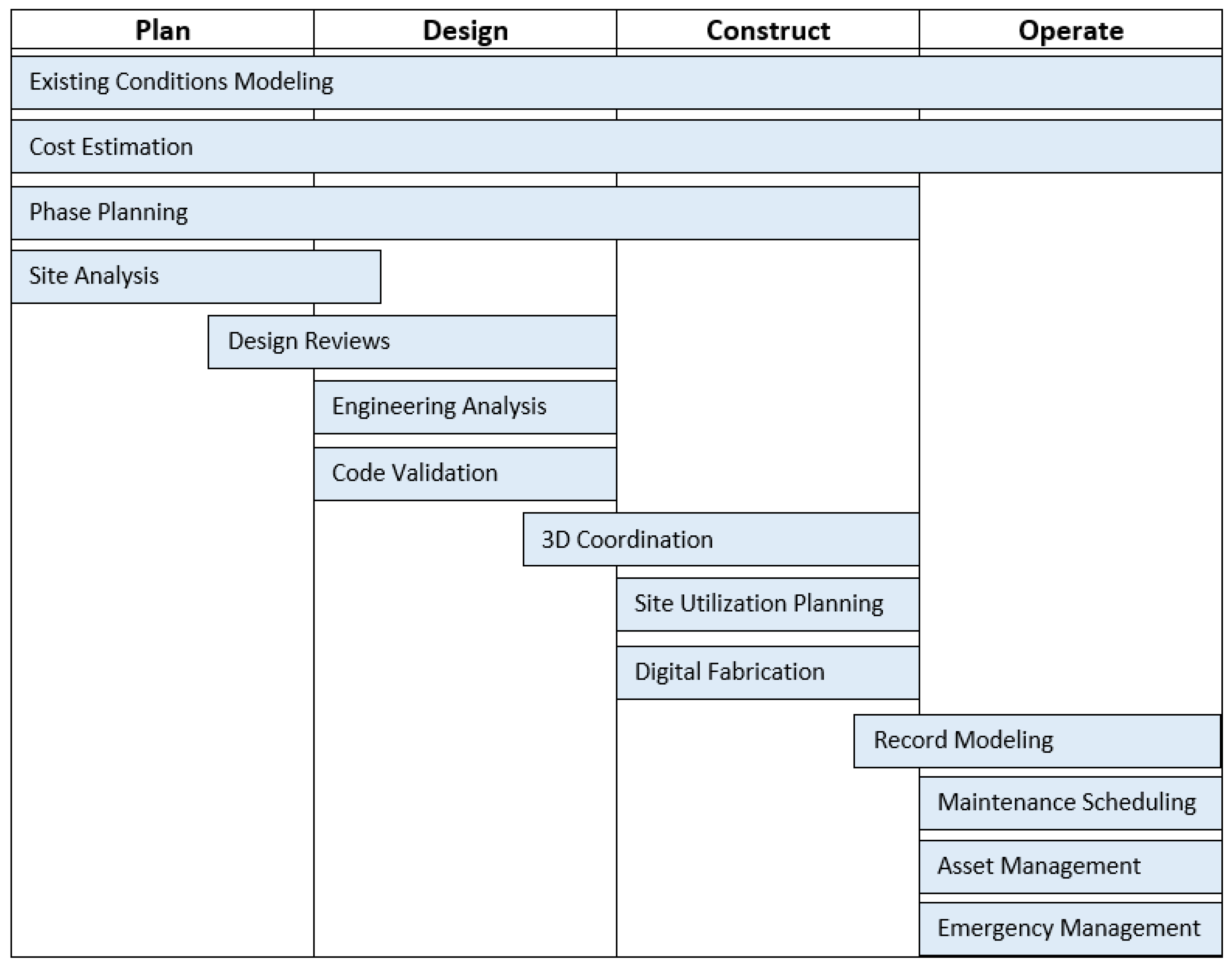
Figure 2.
PRISMA flow diagram.

Figure 3.
Number of Publications by Year.

Disclaimer/Publisher’s Note: The statements, opinions and data contained in all publications are solely those of the individual author(s) and contributor(s) and not of MDPI and/or the editor(s). MDPI and/or the editor(s) disclaim responsibility for any injury to people or property resulting from any ideas, methods, instructions or products referred to in the content. |
© 2023 by the authors. Licensee MDPI, Basel, Switzerland. This article is an open access article distributed under the terms and conditions of the Creative Commons Attribution (CC BY) license (https://creativecommons.org/licenses/by/4.0/).
Share and Cite
MDPI and ACS Style
Belcher, E.J.; Abraham, Y.S. Lifecycle Applications of Building Information Modeling for Transportation Infrastructure Projects. Buildings 2023, 13, 2300. https://doi.org/10.3390/buildings13092300
AMA Style
Belcher EJ, Abraham YS. Lifecycle Applications of Building Information Modeling for Transportation Infrastructure Projects. Buildings. 2023; 13(9):2300. https://doi.org/10.3390/buildings13092300
Chicago/Turabian StyleBelcher, Ethan J., and Yewande S. Abraham. 2023. "Lifecycle Applications of Building Information Modeling for Transportation Infrastructure Projects" Buildings 13, no. 9: 2300. https://doi.org/10.3390/buildings13092300
Note that from the first issue of 2016, this journal uses article numbers instead of page numbers. See further details here.