
The Oval Engravings of Nabara 2 (Ennedi, Chad)


Association des Amis de l’Art Rupestre Saharien, 27100 Pavia, Italy
Arts 2017, 6(4), 16; https://doi.org/10.3390/arts6040016
Submission received: 1 August 2017
/
Revised: 10 September 2017
/
Accepted: 20 September 2017
/
Published: 29 September 2017
(This article belongs to the Collection World Rock Art)
Abstract
:By revisiting the Nabara 2 shelter in the southern Ennedi (Chad), some previously unreported paintings and a whole set of unexpected oval engravings were surveyed. These engravings, internally decorated with patterns of lines, some featured by a single longitudinal element or a sort of reticular structure, make Nabara 2 an unparalleled site among the hundreds known in the region. Comparison with similar motifs associated to human depictions found at the western termination of the Ennedi Highland suggests these engravings could be depictions of shields, attributable to the pastoral period.
1. Introduction
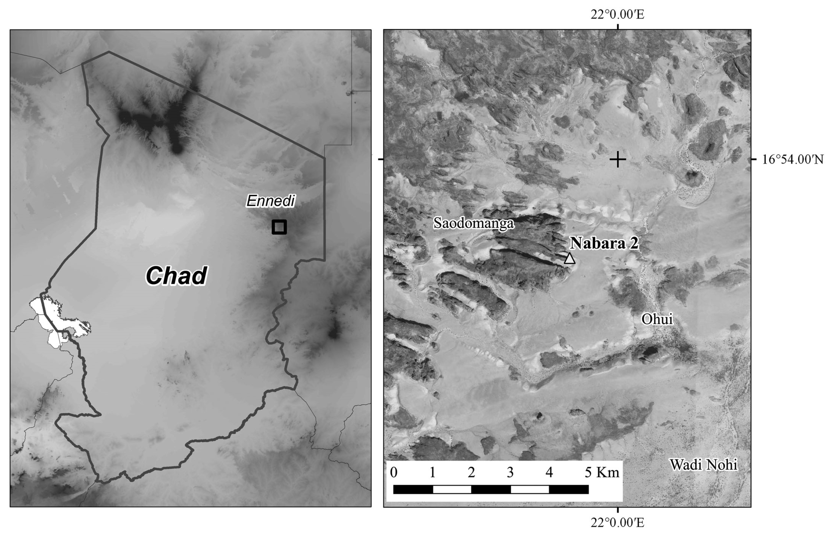
East of the Archeï Guelta, the first right tributary of Wadi Nohui develops into a broad articulated valley with a characteristic two-steps profile dictated by the tabular geology of the region (MEH 2015). The valley bottom, hosting the Ohui village, stretches between walls made of massively bedded fluvial sandstone, Cambrian in age, the top of which forms an elevated sandy plain. This plain is in turn bounded by high faces made of thick sandstone beds of Ordovician age. An erosional outlier, featured by sharp promontories and narrow reentrants, complicates the morphology of the valley to the west (Figure 1). The Ohui villagers name this hill Saodomanga, a place name without any correspondence on the official topographic map compiled by the Institut Géographique National (1961).
Choppy et al. (2003) reported the existence in the area of two painted shelters named Nabara 1 and Nabara 2. The published surveys of these sites, expedite in nature, consist of hand-drawn outlines only. At the time of the first reporting of Nabara 2, the peculiar engravings decorating the upper section of the bottom wall, extending seven to nine meters above the shelter floor, went completely unnoticed.
In February 2017, the Nabara 2 site was revisited with the escort of a professional guide appointed by Aba N’Igai, the well-respected elder leader of the local community who traditionally owns the land. This site was documented exclusively in photography, as allowed by the Chadian authorities, who are promoting tourism in the Ennedi Highlands, a region inscribed on the World Heritage List by UNESCO on 16 July 2016 (UNESCO 2017), under the auspices of the Chadian Ministry of Tourism. The digital pictures shot on site were acquired without physically interfering with the rock art or any visible archaeological remains, in full respect of the local laws and the deontological code established by the AARS Charte (AARS 2009).
2. The Nabara 2 Shelter
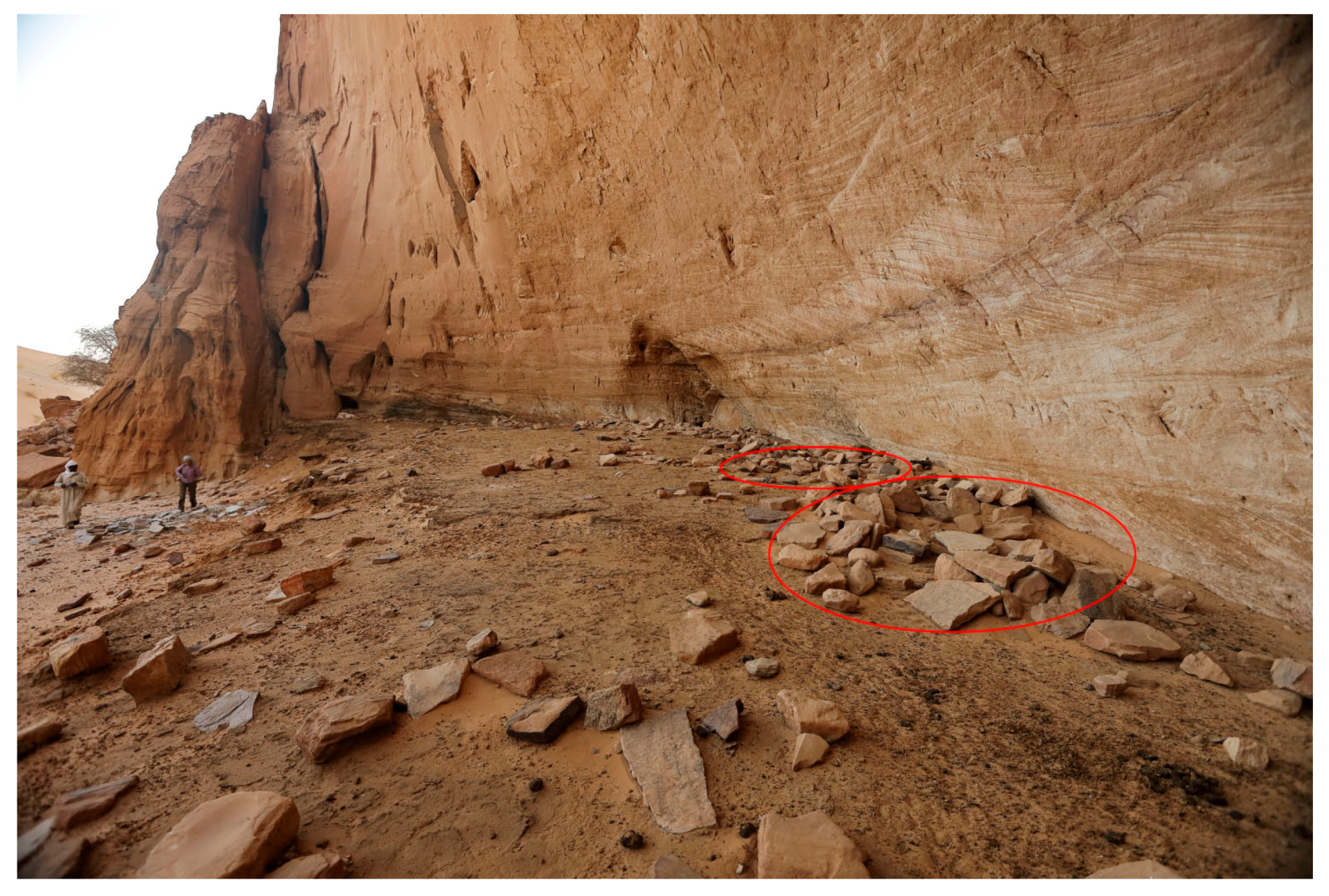
The Nabara 2 shelter is located at 760 m of elevation at the base of the Saodomanga north face (Figure 1). Partially hidden by an imposing sand dune bordering the rocky hill, the shelter is 36 m wide, 16 m high at the brown, with a maximum depth of 7 m (Figure 2). Simple stone structures leaning against the bottom wall and a basin carved in a stone slab offer evidence of an ancient settlement (Figure 3). A layer of manure and recent donkey droppings covering the flat floor proves that wandering animals take refuge in its shadow.
The shelter surface is deeply weathered; erosion by the sandblasting winds is very pervasive in the inner sector of the cavity as the exposure of the bright cross-bedding indicates. The upper wall and the ceiling at the center of the cavity are intensely flaked, presenting a rugged aspect.
In surveying the rock art, the necessary reference frame was set according to the frontal orthographic projection of the 3D model of the shelter (Figure 4), developed in Photoscan (Agisoft LLC, St. Petersburg, Russia) and MeshLab© (Cignoni et al. 2008). The paintings, most of them very faint, were studied by enhancement of digital images with DStretch© (Harman 2017; Le Quellec et al. 2013). Dimensions of the engravings discovered high on the ground, documented using a long lens, were measured on the calibrated 3D model.
3. Recent Engravings and Pastoral Paintings
What strikes one at first sight, entering the shelter, is the presence of white paintings on the easternmost section of the bottom wall, at the unattainable height of 10 to 11 m (Figure 4). By close inspection, the shelter is variously decorated from the soil up to these maximum elevations. The area enclosing all the paintings and petroglyphs extends for about 314 m2.
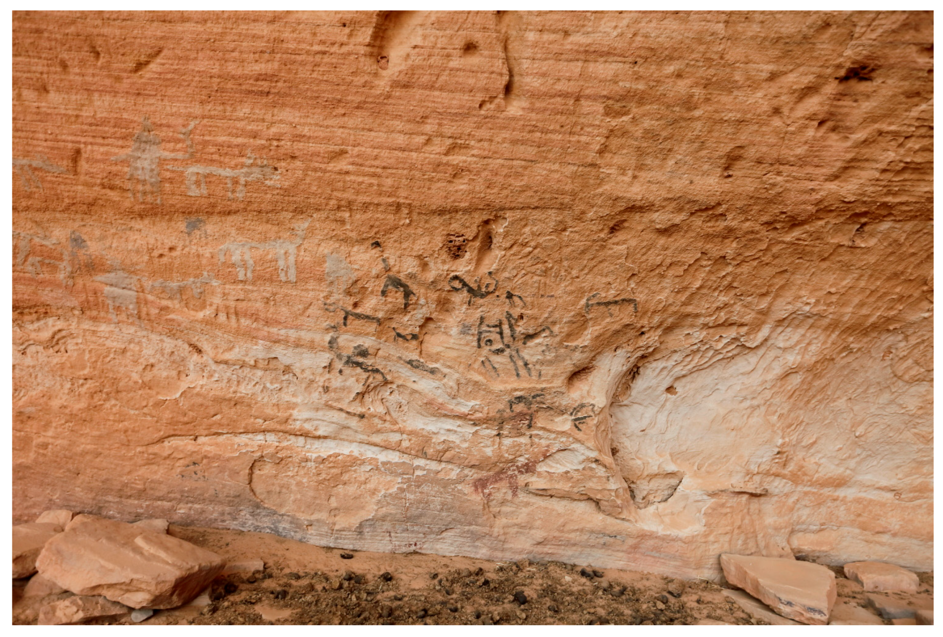
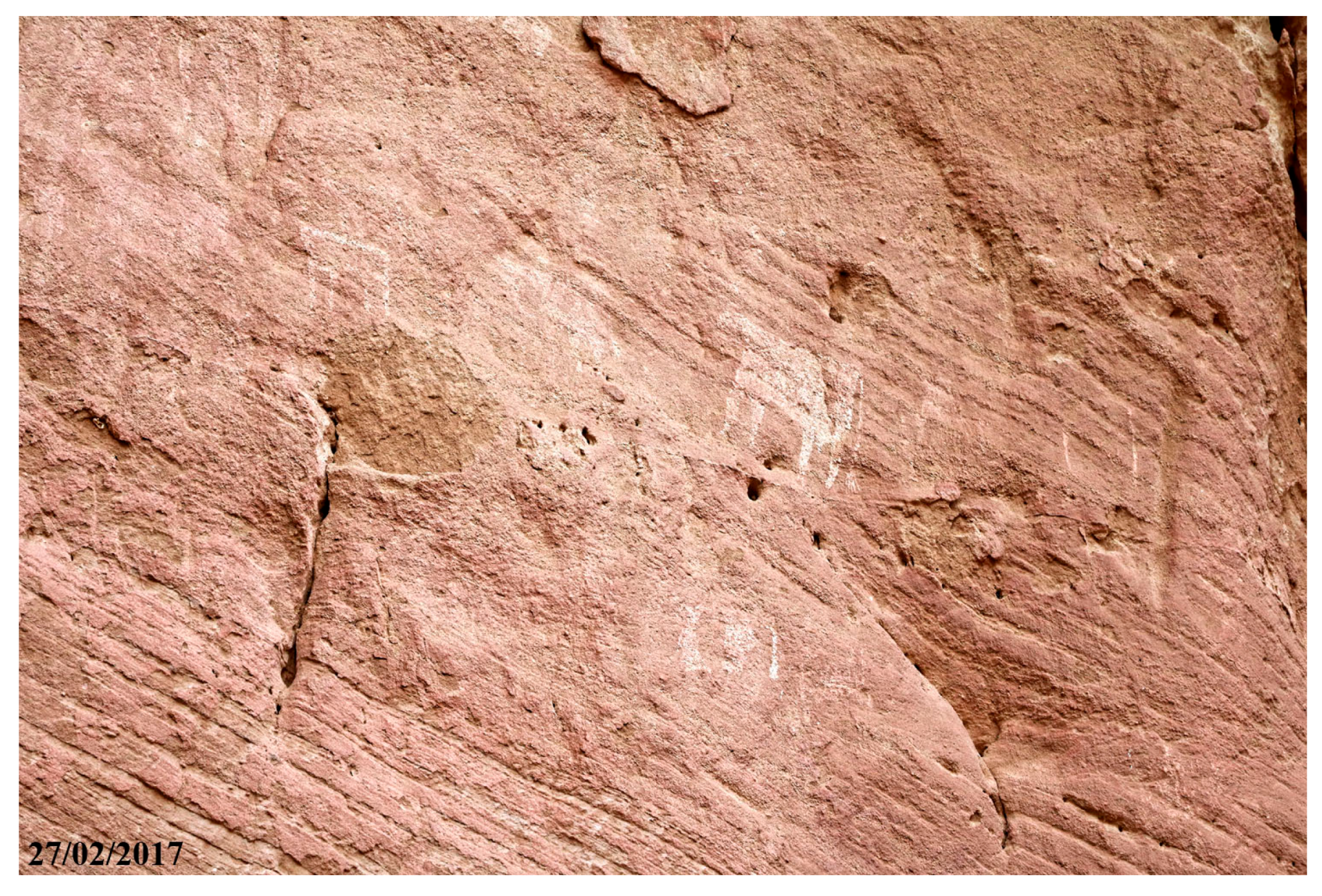
Engraved camels with the hump-body stylized as a triangle and linear marks decorate the base of the rock spur flanking the eastern side of the cavity (Figure 5). On the eastern sector of the shelter’s bottom wall, near to the ground (P1 in Figure 4), pecked camels with the hump stylized as a semicircle, sketchy camels, and other crudely drawn quadrupeds painted in white, grey, and red are shown (Figure 6).
Toward the eastern side of the shelter, 3 m above the ground (P2), 11 aligned warriors armed with lances, partially hidden behind their round shields, are revealed by digitally enhanced images (Figure 7). The identification of these nearly disappeared figures is confirmed by comparison with a similar, better-preserved row of figures shown in Ga Manda IV, 28 km SSW of Fada, a scene considered characteristic of the final “Bovidian” period (Figure 119 in Bailloud 1997). The term “Bovidian,” although deprecated in modern Saharan studies (Di Lernia 2017), is here maintained for easy reference to the published literature.
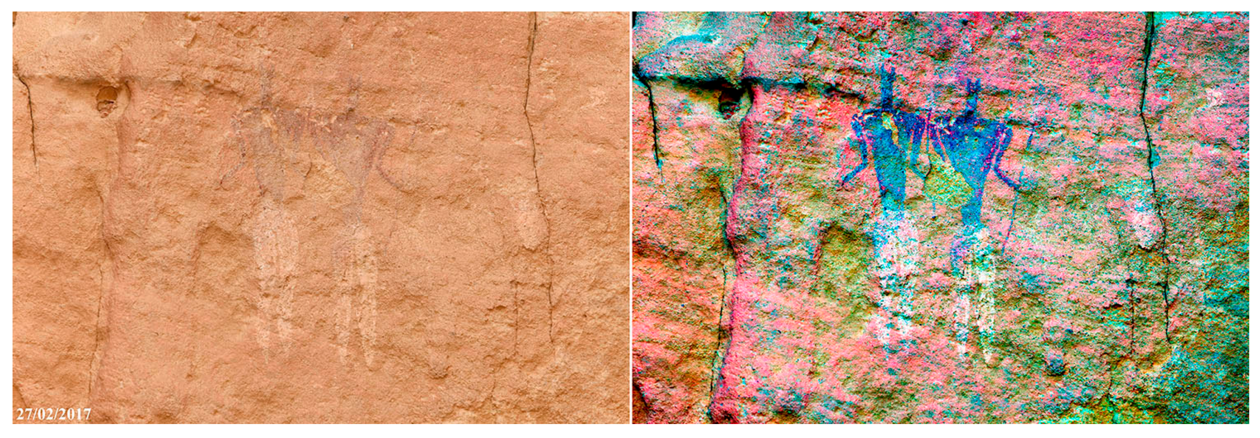
Moving westward, between 3 to 4 m above the floor (P3), a large composition comprehending polychrome human and cattle figures is visible (Figure 8). Long gowns distinguish the women; a spear with a laurel-shaped spearhead characterizes one of the two men standing amid the cattle. The second man is holding a small conical object, likely a quiver, in his right hand. The frontal pose of the human figures, with arms gently flexed outward, is iconic to the vast number of paintings attributable to the recent and final “Bovidian” periods, according to the relative chronology of the Ennedi rock art proposed by Bailloud (1997).
Right of the cattle figures (P4), a pair of warriors equipped with spears and wearing loincloths stand out for the stark contrast between the upper bodies painted in a dark hue of red and the lower bodies painted in white (Figure 9). The pointed terminations of their heads, recalling animal ears, is distinctive of the human figures forming the coral scenes surveyed in the Fada I and Soro Kazenanga I sites, published as iconographic references for the Fada style (Bailloud 1997). Some of the finest and best-preserved examples of human figures featured by this kind of animal ears occur in the Dibirké shelter (Civrac 2014). This kind of head shape, often combined with a pointed lower face, is common to a large number of figures throughout many sites. It likely expresses the symbolic identification of the depicted people with some particular animal or its imagined qualities.
Just above the previously mentioned scene depicting a cattle herd, 4.5 m above the ground, six figures featuring triangularly shaped heads and upper bodies painted in white are evident. Four of them (Figure 10) form by proximity a group scene on a rock protrusion (P5). They wear a sort of shirt or tunic ending in a rounded skirt fastened by a belt. A recumbent piece of fabric, extended from the right hip to the ankle—possibly a sash with the short end on the left hip—confers an unusual elegance to the clothing style of the portrayed individuals.
Above these paintings, at 6 m of elevations (P6), seven white square motifs with appendages are present (Figure 11). These motifs likely depict animal skins, as the appendages could represent the legs and tails of skinned animals. They have just one known correspondence in a site nicknamed “Horned Head Shelter,” located east of the Archeï gorge mouth (Thrust for African Rock Art records in the British Museum Collections online—ID: 2013, 2034.6374).
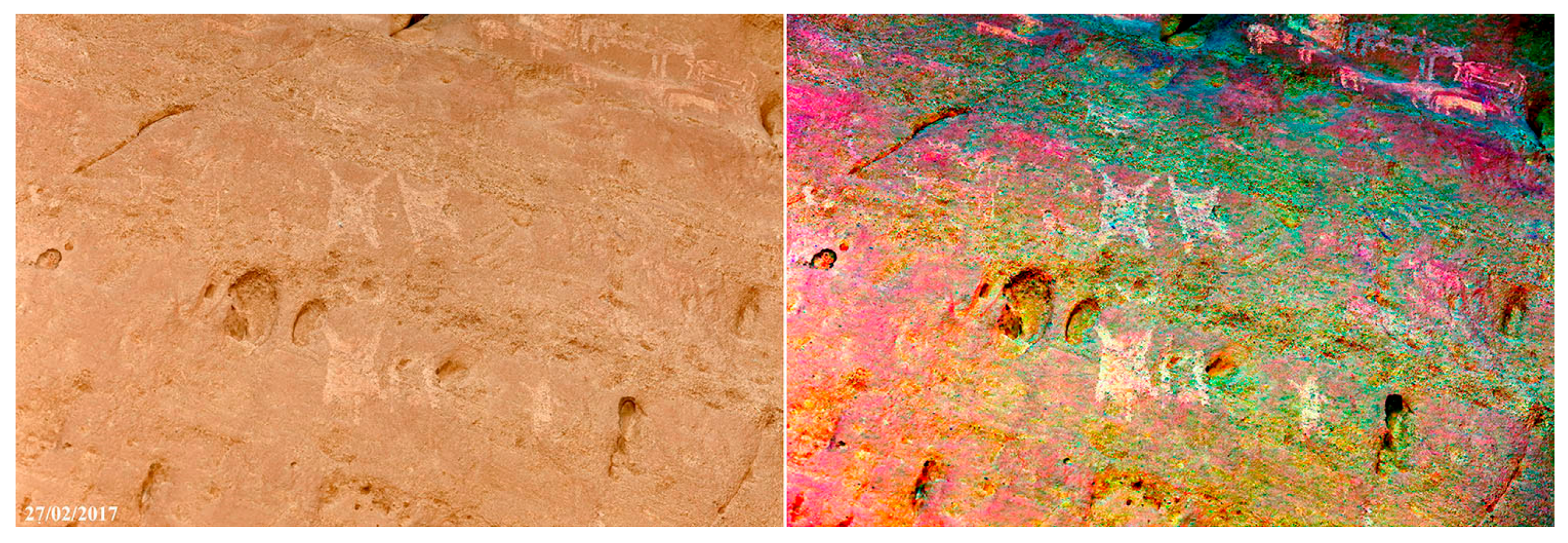
Looking further upward, between 6–8 m on the shelter wall (P7), a number of white remains of cattle figures, 160 as a minimum, plus an isolated painted giraffe crowd the wall over a length of 8 m (Figure 12). At the upper boundary of this cluster, a much worn engraved giraffe and one engraved round shape are present.
At the center of the bottom wall, 4.5 m above the ground (P8), a group of seven bicolour cattle figures with dappled and spotted coats (Figure 13) survives on a small area that escaped the intense erosion affecting the rock surface. To the right of the cattle, the fragmentary remain of a warrior equipped with a round shield is evidenced by image enhancement (Figure 13). The shield is dotted and featured on the upper border by a triangular expansion.
On the western sidewall (Figure 14), 5 m above the ground (P9), remains of left facing cattle figures painted in white and cattle engravings are present.
Unfortunately, without scaffolding, it is not possible to examine the Nabara 2 paintings in much detail. The prehistoric artist certainly did not make use of any artificial mean to access the shelter wall above a person’s height. As it is clear by satellite images, drifting sands move around the Sadomanga hill; erosion prevails to the north and deposition to the south. In the past, with a different wind regime, a dune likely developed against the shelter bottom wall, allowing the prehistoric artists to attain its upper sections. Over time, a change in the balance between erosion and deposition made the shelter floor to subside progressively.
4. The Oval Petroglyphs
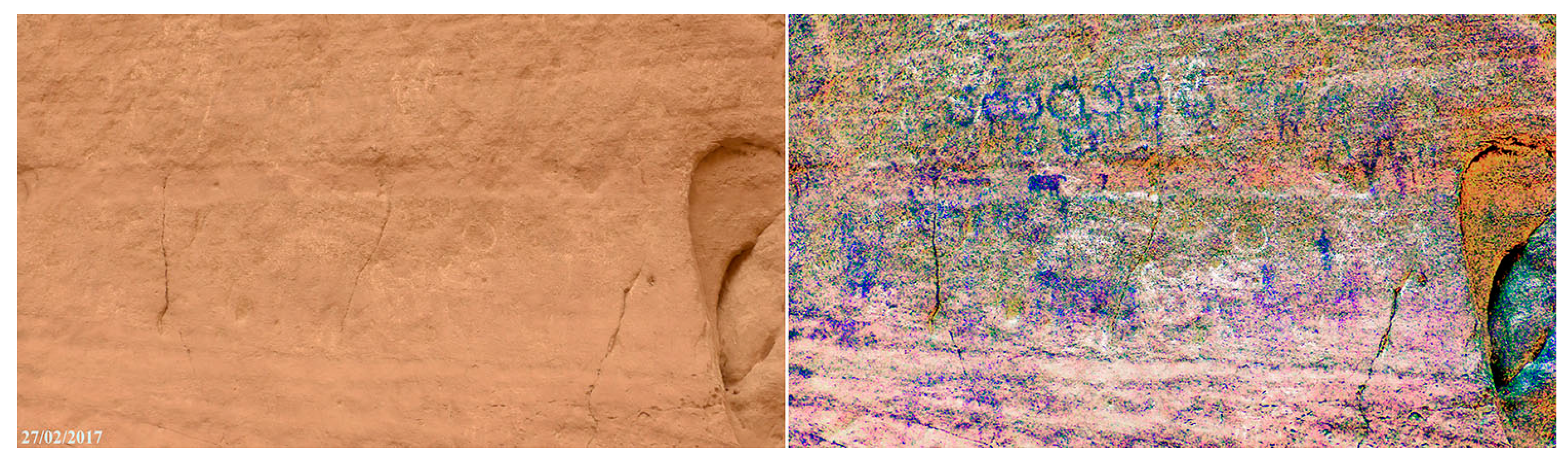
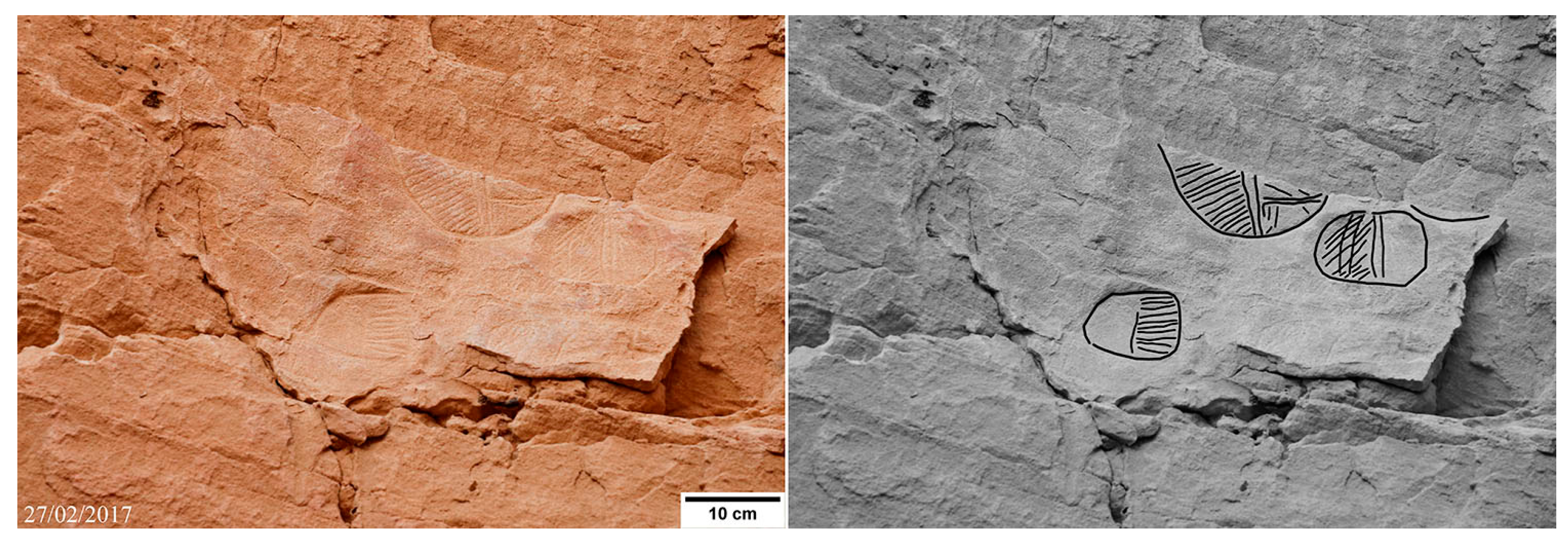
The oval engraved petroglyphs decorating the upper section of the shelter bottom wall, between 7 to 9 m, make Nabara 2 an unparalleled site in the varied rock art landscape of the Ennedi (Figure 15, Figure 16, Figure 17, Figure 18, Figure 19, Figure 20, Figure 21 and Figure 22). Within an area extended about 40 m2, 27 oval engravings are counted. Their deeply engraved outlines, acting as lines of weakness, sometimes favoured the detachment of pieces of rock, giving origin to elliptical gaps. This sort of mould indicates the former existence of many more oval engravings than it is possible to see today. Most of these engravings are just fragments, which survived the intense erosion of the original rock surface. Fortunately, their symmetric shape easily allows imagining these fragmentary motifs in their completeness. Among over 27 engravings, only three are devoid of internal graphical elements. Dimensions are in the 10 to 40 cm range. The most significant ones of the inventory, listed according to their location from east to west (Figure 4), are the following:
- E1 and E2: two oval engravings subdivided into squares by a longitudinal element and four transversal elements resembling a framework (Figure 15). Patterns of differently angled lines fill the square subdivisions within the reticulate motif.
- E3: a cluster of partially preserved oval engravings (Figure 16). A vertical element drawn by two parallel lines halves in two the largest one, apparently surviving for the lower third of its original area only. A pattern of oblique lines, up left-to-right, fills the left part. A thin horizontal stripe joins the vertical element on the lower right part; patterns of oblique and vertical lines decorate the spaces above and below. A longitudinal vertical element subdivides the small oval engraving to the right; an irregular grid pattern fills the right part. A pattern of lines, up left-to-right, decorates the left part; two slightly curved vertical lines intersect this pattern. A pattern of horizontal lines decorates the upper right quarter of the lowest engraving of the cluster, while the left upper quarter is apparently void. Short segments of the outlines of two more oval engravings are recognizable near the upper and lower border of the eroded surface hosting the E3 cluster.
- E4: two paired oval engravings. A vertical longitudinal element subdivides the one to the right into two sectors, internally decorated with horizontal lines (Figure 17). A reticular graphic element subdivides into squares the oval engraving to the left. Patterns of oblique lines, up left-to-right and up right-to-left, symmetrically fill the resulting square subdivisions.
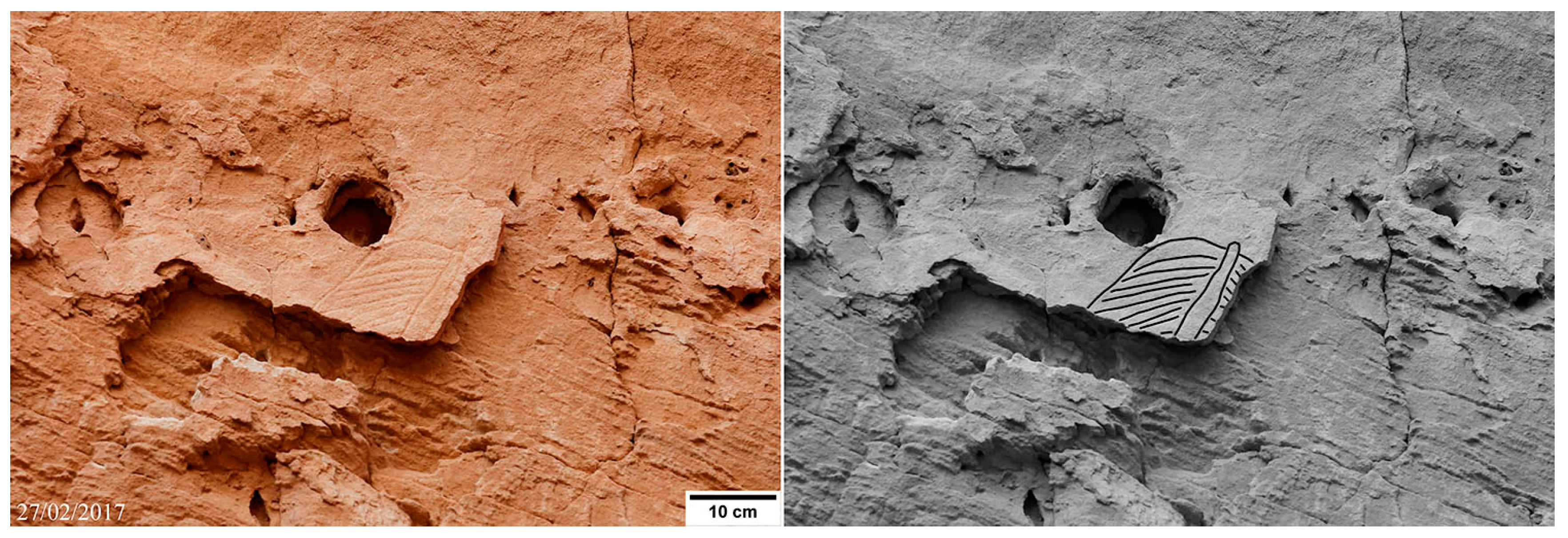
- E5: a fragment of an oval engraving featured by a longitudinal element with a tapering end jutting out from the round edge (Figure 18). A pattern of lines, up left-to-right, fills the surviving left upper quarter of what could have been the original motif. A pattern in mirror symmetry, up right-to-left, decorated the right part, as can be deduced by the narrow strip of engraved rock still preserved to the right of the longitudinal element.
- E6: an oval motif survived the destructive flaking process only by its central part (Figure 19). Deeply engraved horizontal lines define strips of different height, each one filled with angled grids. To its lower left and right, tiny relics of four more engravings are visible. The three to the right preserve traces of internal decorations.
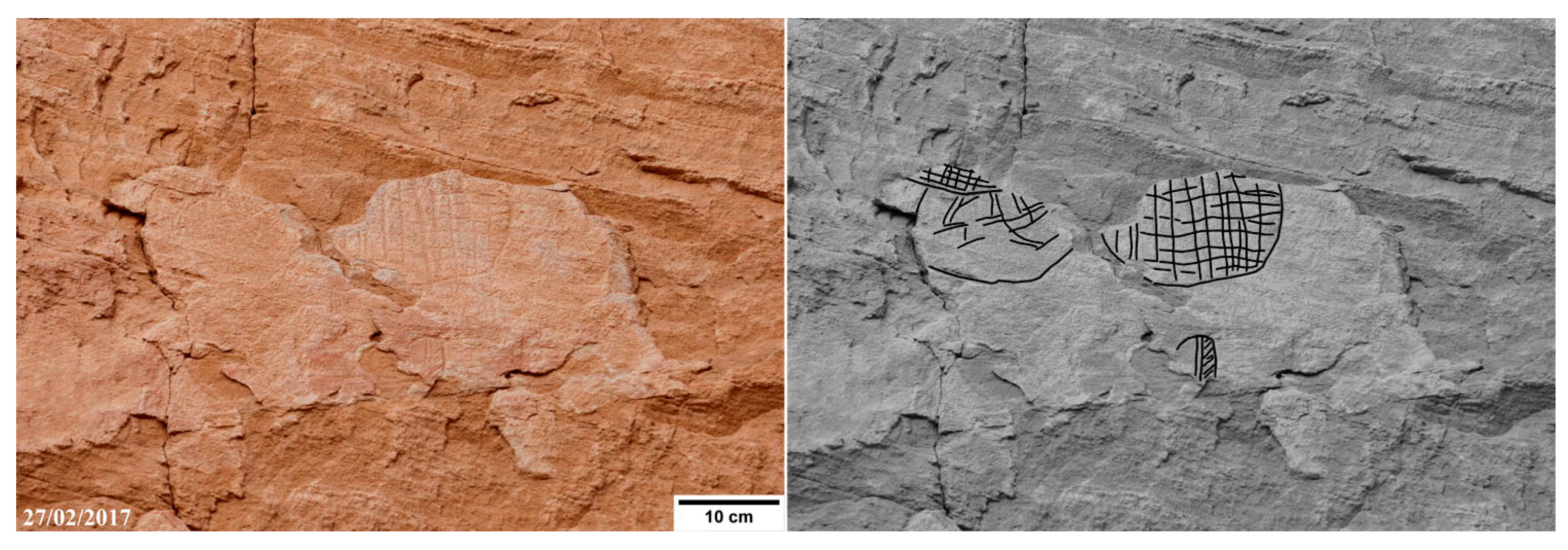
- E7: a cluster of four oval engravings. The central one is a simple wide rounded shape with an internal pattern made of an irregular rectangular grid (Figure 20). The one to the left, similar in size but almost completely deleted by erosion, is decorated with a disorderly pattern of crossing lines. A possible third engraving, decorated with a pattern of angled grid and preserved as a very small fragment, is apparently overlapping the top of the left engraving. Few centimetres below the central engraving, a much smaller oval engraving is visible. A vertical element traced by two lines subdivides this oval into two parts; a pattern of oblique lines, up left-to-right, fills the right part.
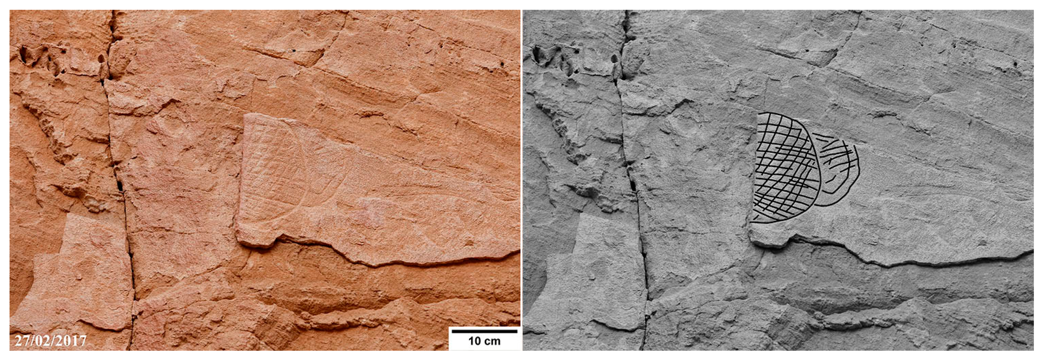
- E8: two partially overlapping oval shapes (Figure 21). A pattern made of angled lines features the engraving in the foreground. A double rim and a rectangular grid with horizontal lines more deeply incised characterize the engraving in the background.
- E9: an oval engraving featured by patterns of angled lines, without a clearly organized internal order (Figure 22).
5. The Nabara 2 Oval Engravings in Their Regional Context
Oval petroglyphs as isolated motifs, not directly associated with human depictions, are rare in the Ennedi rock art. The execution of all the previously reported cases is by pecking thus a direct comparison with the Nabara 2 engravings and is clearly difficult and questionable.
Oval petroglyphs internally decorated by irregular grids resembling meshes, simply reported as enigmatic (Simonis 1996), distinguish an open-air site named Azrenga, located 215 km to the NE of Nabara 2. Two coupled petroglyphs similar to the Azrenga ones, documented in site T05/532 (Figure 2 in Lenssen-Erz 2015) in the south-eastern region of the Ennedi, were described as idiosyncratic motifs of almost universal occurrence. However, a horizontal line crosses the irregular mesh of the left petroglyph in site T05/532, while two oblique lines forming a chevron cross the petroglyph to the right. These details, clearly differentiating the two petroglyphs, remain unexplained.
In a site reported near Anoa, 165 km to the NW of Nabara, oval petroglyphs, internally decorated with irregular grids, occur both as isolated motifs and as handheld objects (Kröpelin 2016). As handheld objects, they are large enough to cover a person and appear enough light in weight to be held by an outstretched arm. According to the proposed interpretation (ibid.), these motifs, interpretable as shields or hunting nets, could actually be fishnets, and their bearers could be depictions of prehistoric anglers, indicating the former existence of nearby permanent lakes now hidden under the sand.
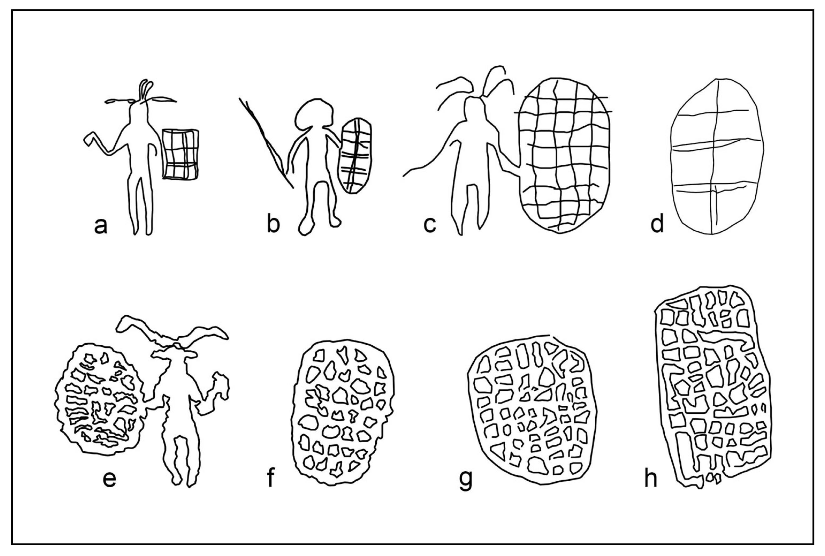
Perhaps the best analogues of the Nabara 2 oval engravings are found in the petroglyphs of Anoa 1, a site located in the extreme north-western sector of the Ennedi, originally documented in photography by Jean Courtin in 1965 but published as hand drawings only (Choppy et al. 1996). In this site, human figures holding oblong objects and isolated motifs identical to these oblong objects appear on the same panels, side by side (Figure 23). The internal square partitions of the objects in “b” and “d” (Figure 23) are comparable to the partitions of the Nabara 2 oval engravings shown in Figure 15. Actually, this resemblance is the best argument in favour of a common identification for the Nabara 2 oval engraved petroglyphs and the Anoa 1 pecked petroglyph since it could be hardly casual. The human figures depicted in Anoa 1, holding also a mace or a short spear (Figure 23, “a,” “b,” and “c”), are associated with cattle figures. They likely depict armed people attending herds, and the oval objects are best identified with shields. Partitions on these objects could represent geometric decorations or structural details.
The “a” petroglyph (Figure 23) evidently does not relate to an oval object but to a square one, which resembles a kind of square wickerwork shield widespread in Central Africa (Figure 33 in Benitez-Johannot et al. (2010); Quais Branly Jacques Chirac Museum (http://www.quaibranly.fr/fr/explorer-les-collections/), online collections, Inventory number 71.1935.80.95). The profile of the object held with the right hand in the “a” petroglyph recalls the African traditional mace still in use in Africa up to historical times among the Peul of Sub-Saharan Africa, as well among the tribes of South Africa (Quais Branly Jacques Chirac Museum, online collections, Inventory number: 71.1908.13.138 and 71.1942.0.394 X). The interpretation of this specific figure provides more support to the interpretation of the other human depictions surveyed in Anoa-1 as warriors equipped with a certain variety of shields and offensive weapons. Although each African ethnic group tends to have its distinctive kind of standard shield, pictures preserved in the Pitt Rivers Museum photographic collection, shot at the end of the nineteenth century, show tribal squads of African warriors equipped with shields of different shape and building technique (e.g., accession numbers 1998.209.43.7 and 1998.203.1.65.2; Pitt Rivers Museum 2017).
Interestingly, among the pecked humans holding weapons from the western Ennedi, the oval or square objects interpreted as shields are generally held with the left arms, i.e. the natural choice for right-handed people when it comes to fighting with a shield and a mace or a spear. The “e” petroglyph (Figure 23) represents just the single case of such an oval object held with the right hand over nine similar documented depictions (Choppy et al. 1996; Kröpelin 2016). The observed distribution between left and right arm is easy to explain since the percentage of left-handed people is genetically predetermined, with a percentage of right-handed between 70 to 95% (Holder 2001). If these objects were representations of net-traps, fishnets or any other possible tool they would have been likely represented as objects handheld mainly with the right arm.
Items from traditional African societies collected in ethnographic museums suggest prehistoric shields were made of woven reeds or wicker, wood, and animal hides (Benitez-Johannot et al. 2010; Petch and Dudley 1997). Shields made of reeds or wicker could be very effective in protecting from thrusting weapons because of their flexibility. Wicker shields are light in weight, and the raw material is easily available wherever lakes or swamps are present, as they should have been in the ancient environment of the Ennedi, which was more humid in prehistory (Kröpelin et al. 2008). A building technique based on wicker or rattan woven over a wood framework could explain in the simplest way the geometric features of most of the oval engraved motifs decorating Nabara 2. The longitudinal and transversal elements or the single longitudinal element observed within the most elaborate engravings likely represent wooden frameworks or wooden poles, indicating a variety of building characteristics, as observed in the Barbier-Mueller African collection of shields (Benitez-Johannot et al. 2010). In particular, the jutting-out element observed in the engraving of Figure 18 strikingly resembles the pole top end of a shield collected in Chad (Quais Branly Jacques Chirac Museum, online collections, Inventory number: 71.1930.42.32). The longitudinal-pole design in a shield is actually one with a wide geographic diffusion, mainly used in shields made of leather. It derives from the most elementary, primitive kind of shield, i.e., the parrying stick, a stick suitable to ward off a blow in fighting at close range with an offensive weapon like a spear or a club (Petch and Dudley 1997). Therefore, it would be not strange to have this kind of design represented in Nabara 2, along with shields of different design, if the oval engravings really represent shields built in the prehistoric past, whatever could be the age of the petroglyphs.
It is worth noting that in the Benitez-Johannot vast collection, shields of wicker from the Central African countries, including Cameroon and Chad, largely outnumber shields made of wood or leather, while the elongate oval shape predominates other shapes. However, a shield made of a plank of wood, if translated into an engraving, could be indistinguishable from a shield of wicker, since simple decorations of wooden surfaces mimicking woven fibres are in the record.
Shields are primarily defence devices, but for the sophistication of the building techniques, for their decorations showing personal identity, clan, or army appurtenance, they can also be objects of prestige, with a symbolic and affective value attached (ibid.). In the Chéïré-1 shelter, decorated round shields, shown as handheld objects and as motifs per se (Figures 6 and 7 in Menardi Noguera and Bonomo (2014)), offer good evidence that among some cattle pastoral societies of the Ennedi past, patterned shields could have stood for their owners as heraldic blazons. In this light, the described oval engravings, if correctly interpreted as shields, could have been the coats of arms of an important clan, which elected Nabara 2 as a site of special significance.
In the lack of any direct superimposition with paintings, it is not possible to establish the placement of the Nabara 2 oval engravings in the relative chronology of the Ennedi rock art by the usual method. However, these engravings could be contemporary or older in respect of the cattle figures painted on the eastern shelter side at the same elevation from the floor. They should be older than the paintings attributable to the final cattle period documented about two meters below and painted in a time when the upper sector of the shelter wall was already out of reach.
6. Future Research Avenues
In order to test the proposed iconographic identification of the Nabara 2 oval engravings with shields, more sites with analogous motifs, possibly associated to human depictions, should be searched for and studied. Sole reliance on ethnographic collections for identification of motifs in the prehistoric art without archaeological evidence from ancient artefacts is problematic since the traditional African societies of the colonial era did not live in a fossilised cultural past. In rock art studies, only typological analysis based on large samples could be a partial remedy to the lack of hard data from archaeological digs.
More research in this field is evidently necessary, especially in the core sector of the Ennedi Highland neighbouring the Nabara 2 shelter.
7. Conclusions
The discovery of the Nabara 2 oval engravings, a true novelty in the rock art of the Ennedi panorama dominated by the absolute prevalence of pecked petroglyphs, leads to consider the implications of a possible singularity in the panorama of the regional rock art. Although some of the thousands of known paintings and petroglyphs in the Sahara appear as masterpieces for the unequalled excellence of execution and imaginative power, most of the rock art is serial and recursive. It is in the literature that the prehistoric artists of the Ennedi developed motifs drawing from a very restricted selection of all the possible animate or inanimate models existing in their real world. This is especially true for the pastoral art, which is highly standardised. The frequency of motifs varies from site to site, but it is difficult to find examples of motifs without matches. For these reasons, any apparent oddity in the regional rock art raises questions, as it can be due to the taphonomic factor or to insufficient observations. The selection operated by the taphonomic factor should be always considered before drawing any conclusion about the representativeness of the surviving rock art of any region (Bednarik, 1994). In the case of the Nabara 2 oval engravings, largely destroyed by weathering agents, the taphonomic factor is evidently relevant. The rarity of this kind of petroglyph is certainly in relation to their preservation chance through the ages. However, insufficient or inaccurate observations could also have an effect, notwithstanding the large number of reported rock art sites from the Ennedi, which is in excess of 400. As Nabara 2 itself demonstrates, the survey quality of the many gigantic shelters known in the region is unsatisfactory. Moreover, most of the past exploration for rock art was concentrated along the easy to access lower sections of its ramified drainage system, thus creating a geographical bias in the available documentation. Interestingly, Lenssen-Erz (2012), studying sample areas in the Ennedi, noted a pattern in the distribution of different motifs according to the compartmentalization of the territory, with certain motifs appearing only in some specific sections of the landscape. Therefore, some surprises might emerge in future surveys, transitioning from the best-known southern valleys to the poorly explored core area of the Ennedi. In this light, the discovery of the oval engravings of Nabara 2 is an addition to the inventory of known motifs, proving the existence of a more varied rock art than the sheer number of reported sites allows.
Acknowledgments
David Coulson (Thrust for African Rock Art), Jean Courtin, and Stefan Kröpelin (Köln University, Germany) kindly disclosed critically important information about the reference sites. A special thank goes to Aba N’Ingai, the elder leader of the Ohui community, and his son Saleh for their guidance and advice in visiting their beautiful land and its rock art sites. The visit of the Nabara 2 shelter is the result of a team effort by Paolo Carmignoto, Mauro Colella, Pascale Hégy, and Nicole Honoré. Spazi d’Avventura, specialized tour operator based in Milan (Italy), in the persons of Tommaso Ravà and Adriana Ravenna, provided with much kindness the logistics. The Chadian Tour Operator Société de Voyages Sahariens SVS—TCHAD, which took care of all the practical aspects of the travel to the Ennedi and obtained all the necessary permits from the Chadian authorities, is also acknowledged.
Conflicts of Interest
The author declares no conflicts of interest.
References
- AARS. 2009. Rules of Behaviour on the Rock Art Sites. Association des Amis de l’Art Rupestre Saharien. Available online: https://aars.fr/deontologie_en.html (accessed on 3 September 2017).
- Bailloud, Gerard. 1997. Art Rupestre en Ennedi. Saint-Maur-des-Fossés: Éditions Sépia. [Google Scholar]
- Bednarik, Robert G. 1994. A Taphonomy of Palaeoart. Antiquity 258: 68–74. [Google Scholar] [CrossRef]
- Benitez-Johannot, Purissima, Alain-Michel Boyer, and Jean Paul Barbier. 2010. Shields: Africa, Southeast Asia, and Oceania. From the Collections of the Barbier-Mueller Museum. New York: Prestel Publishing. [Google Scholar]
- Choppy, Jacques, Brigitte Choppy, Sergio Scarpa Falce, and Adriana Scarpa Falce. 1996. Images Rupestres de l’Ennedi, Tchad: Zone Nord—Niola Doa. 1° Partie. Fleurier: J. Choppy. [Google Scholar]
- Choppy, Jacques, Brigitte Choppy, Sergio Scarpa Falce, and Adriana Scarpa Falce. 2003. Images Rupestres de l’Ennedi, Tchad: Le Centre et le Sud-est. 3° Partie. Fleurier: J. Choppy. [Google Scholar]
- Cignoni, Paolo, Marco Callieri, Massimliano O. Corsini, Matteo Dellepiane, Fabio Ganovelli, and Guido Ranzuglia. 2008. MeshLab: An Open-Source Mesh Processing Tool. Paper presented at Sixth Eurographics Italian Chapter Conference, Salerno, Italy, 2–4 July; pp. 129–36. [Google Scholar]
- Civrac, Marie-Anne. 2014. Le Site a Peintures Rupestres de Dibirké au Sud-ouest de l’Ennedi (Tchad). Les cahiers de l’AARS 17: 75–81. [Google Scholar]
- Di Lernia, Savino. 2017. The archaeology of rock art in Northern Africa. In The Oxford Handbook of the Archaeology and Anthropology of Rock Art. Edited by David Bruno and Ian J. McNiven. Oxford: Oxford University Press. [Google Scholar] [CrossRef]
- Harman, Jon. 2017. DStretch (plugin to ImageJ). Available online: http://www.dstretch.com/ (accessed on 3 September 2017).
- Holder, M. K. 2001. Why Are More People Right-Handed? Available online: https://www.scientificamerican.com/article/why-are-more-people-right/ (accessed on 3 September 2017).
- Institut Géographique National. 1961. Archeï. République du Tchad—Feuille NE-34-IV. Fond Topographique au 1/200,000. [Google Scholar]
- Kröpelin, Stefan. 2016. Secret Sahara Reveals Fairy-Tale Formations and Ancient Lakes. Available online: https://www.newscientist.com/article/2077342-secret-sahara-reveals-fairytale-formations-and-ancient-lakes/ (accessed on 3 September 2017).
- Kröpelin S., Dirk Verschuren, Anne Marie Lézine, Hilde Eggermont, Christine Cocquyt, Pierre. Francus, Jean-Pierre Cazet, Daniel Joseph Conley, Matieu Schuster, and Daniel R. Engstrom. 2008. Climate-Driven Ecosystem Succession in the Sahara: The Past 6000 Years. Science 320: 765–68. [Google Scholar] [CrossRef] [PubMed]
- Le Quellec, Jean-Loic, Jon Harman, Frédérique Duquesnoy, and Claudia Defrasne. 2013. DStretch® et l’Amélioration des Images Numériques: Applications à l’Archéologie des Images Rupestres. Les Cahiers de l’AARS 16: 177–98. [Google Scholar]
- Lenssen-Erz, Tilman. 2012. Pastoralist Appropriation of Landscape by Means of Rock Art in Ennedi Highlands, Chad. Afrique. Archéologie et Arts 8: 27–43. [Google Scholar] [CrossRef]
- Lenssen-Erz, Tilman. 2015. Cooperation or Conflict? Identity and Scarce Resources of Prehistoric Saharan Pastoralist. African Study Monographs 36: 5–26. [Google Scholar]
- MEH. 2015. Carte hydrogéologique de la République du Tchad au 1:200,000, Ouvrages et Ressources, feuille NE-34-04 Archeï. Ministre de l’Elevage et de l’Hydraulique. Produit réalisé par UNITAR et Swisstopo, Genève et Berne. Available online: https://reseau-tchad.org/upload/Documents/Cartes/NE34-04_Archei_2015_MEH_web.pdf (accessed on 3 September 2017).
- Menardi Noguera, Alessandro, and Andrea Bonomo. 2014. The Chéïré-1 Painted Shelter (Ennedi, Chad). Paper presented at AARS meeting, Bergamo, Italy, May 31. [Google Scholar] [CrossRef]
- Petch, Alison, and Sandra Dudley. 1997. Shields and Objects, Anthropology and Museums. Available online: http://era.anthropology.ac.uk/Era_Resources/Era/Pitt_Rivers/misc/introset.html (accessed on 3 September 2017).
- Pitt Rivers Museum. 2017. Pitt Rivers Museum Database of Photograph Collections. Available online: https://www.prm.ox.ac.uk/databases (accessed on 3 September 2017).
- Simonis, Roberta. 1996. Azrenga. In Arte Rupestre nel Ciad. Borku—Ennedi—Tibesti. Edited by Negro Giancarlo, Adriana Ravenna and Roberta Simonis. Segrate: Pyramids, pp. 86–89. [Google Scholar]
- United Nations Educational Scientific and Cultural Organization (UNESCO). 2017. Ennedi Massif: Natural and Cultural Landscape. Available online: http://whc.unesco.org/en/list/1475/documents/html (accessed on 24 September 2017).
Figure 1.
Location map of the Nabara 2 shelter. The satellite image in the background is from Digital Globe (Westminster, CO, USA)—Google Earth (Google, Inc., Mountain View, CA, USA).
Figure 1.
Location map of the Nabara 2 shelter. The satellite image in the background is from Digital Globe (Westminster, CO, USA)—Google Earth (Google, Inc., Mountain View, CA, USA).

Figure 2.
View of the Nabara 2 shelter from the dune bordering the Saodomanga hill to the north (Photo: Alessandro Menardi Noguera).
Figure 2.
View of the Nabara 2 shelter from the dune bordering the Saodomanga hill to the north (Photo: Alessandro Menardi Noguera).

Figure 3.
View from west of the Nabara 2 shelter (Photo: Alessandro Menardi Noguera). Small stone circles lie against the bottom wall (red ellipses).
Figure 3.
View from west of the Nabara 2 shelter (Photo: Alessandro Menardi Noguera). Small stone circles lie against the bottom wall (red ellipses).

Figure 4.
Orthophoto of the Nabara 2 shelter. The origin of the metric reference frame is set coincident with the eastern lower corner of the shelter. Stars indicate oval engravings; squares indicate painted compositions. Blobs bound major clusters of white cattle figures. Labels P1–P9 and E1–E9 refer to the engravings and art locations mentioned in the text.
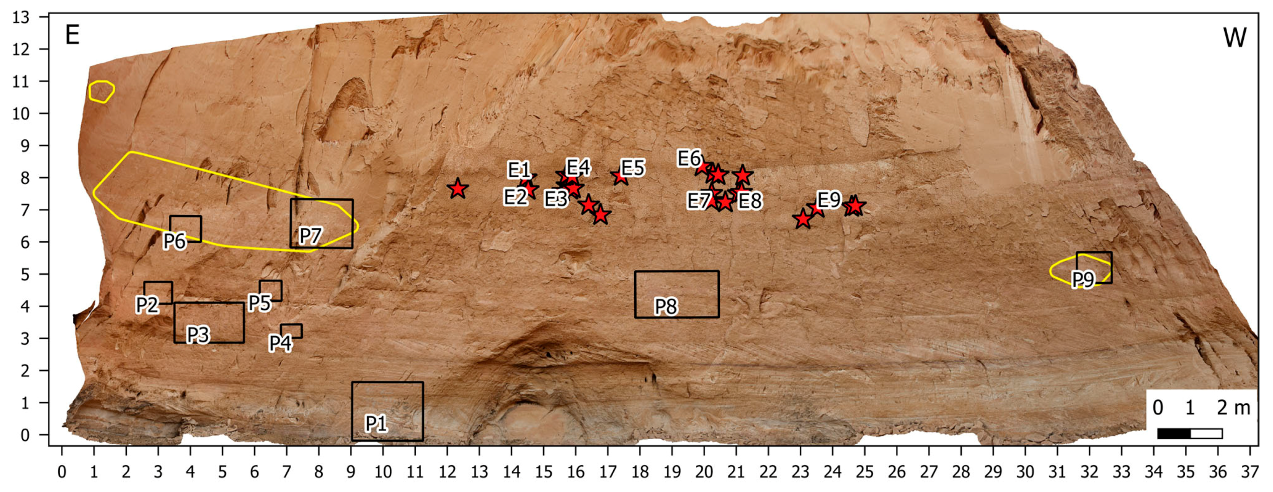
Figure 5.
Engravings of camels and linear marks at the base of the rocky spur flanking the eastern side of the shelter (Photo: Mauro Colella).
Figure 5.
Engravings of camels and linear marks at the base of the rocky spur flanking the eastern side of the shelter (Photo: Mauro Colella).
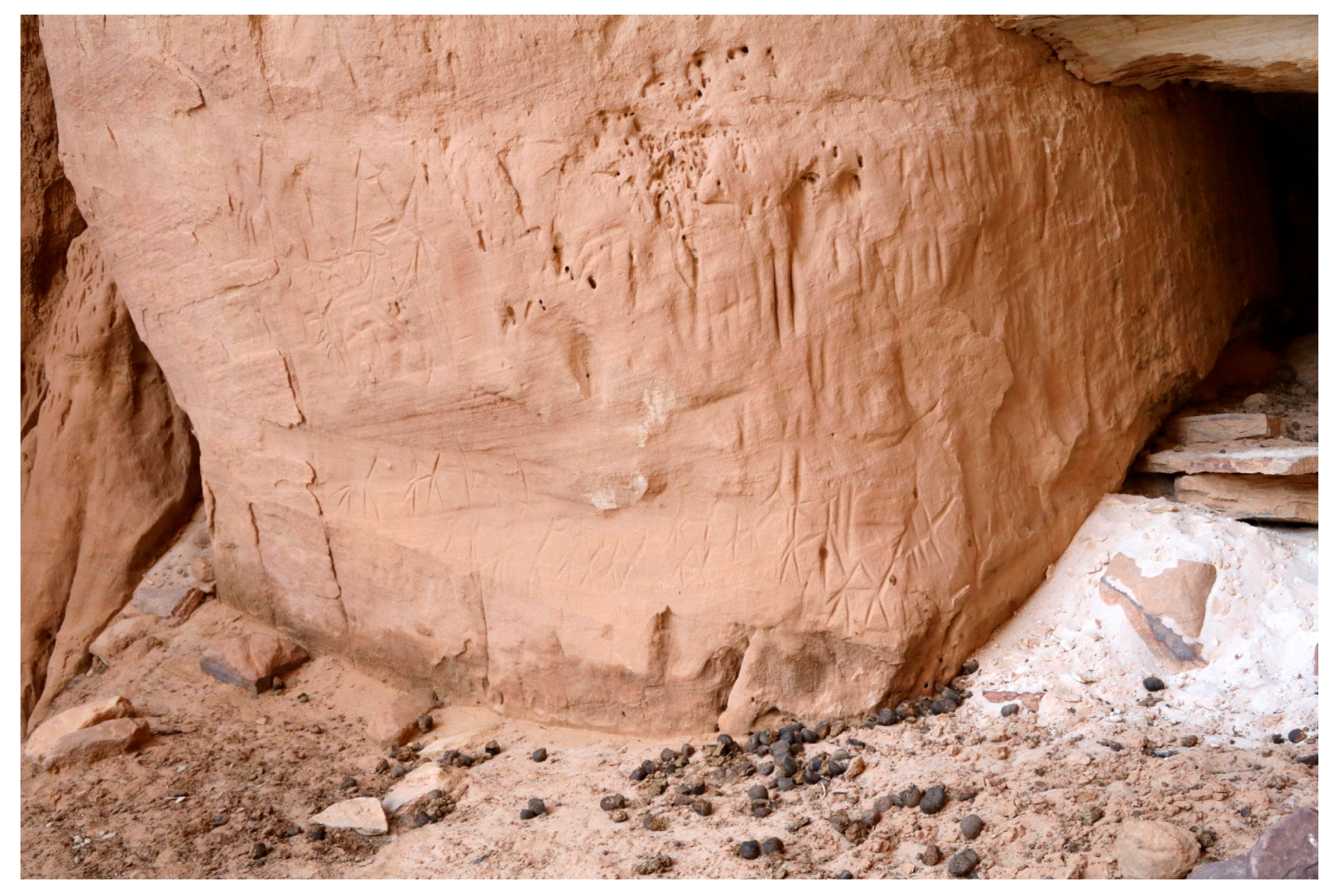
Figure 6.
Schematic camels and undeterminable quadrupeds painted on the bottom wall of the shelter at P1 (Photo: Alessandro Menardi Noguera).
Figure 6.
Schematic camels and undeterminable quadrupeds painted on the bottom wall of the shelter at P1 (Photo: Alessandro Menardi Noguera).

Figure 7.
Faded paintings on the eastern sector of shelter wall, at P2 (Figure 4). The enhanced image to the right (DStretch YBK colour space) shows a line of warriors, partially hidden behind round shields (Photo: Mauro Colella).
Figure 7.
Faded paintings on the eastern sector of shelter wall, at P2 (Figure 4). The enhanced image to the right (DStretch YBK colour space) shows a line of warriors, partially hidden behind round shields (Photo: Mauro Colella).

Figure 8.
A large composition (P3) comprehending three women and two warriors, one armed with a spear, standing amid a cattle herd (Photo: Alessandro Menardi Noguera). The upper image is a photo-mosaic compiled by stitching three high-resolution pictures (on the lower half: enhanced version of the mosaic in DStretch LAB colour space).

Figure 9.
Two warriors armed with spears at P4 (Photo: Alessandro Menardi Noguera). The pointed terminations of their heads recall animal ears (enhanced version to the right in DStretch LAB colour space).
Figure 9.
Two warriors armed with spears at P4 (Photo: Alessandro Menardi Noguera). The pointed terminations of their heads recall animal ears (enhanced version to the right in DStretch LAB colour space).

Figure 10.
Four figures wearing white clothes, at 4.5 m above the shelter floor at P5 (Photo: Alessandro Menardi Noguera). Legs are painted in dark red (enhanced version to the right in DStretch LAB colour space).
Figure 10.
Four figures wearing white clothes, at 4.5 m above the shelter floor at P5 (Photo: Alessandro Menardi Noguera). Legs are painted in dark red (enhanced version to the right in DStretch LAB colour space).
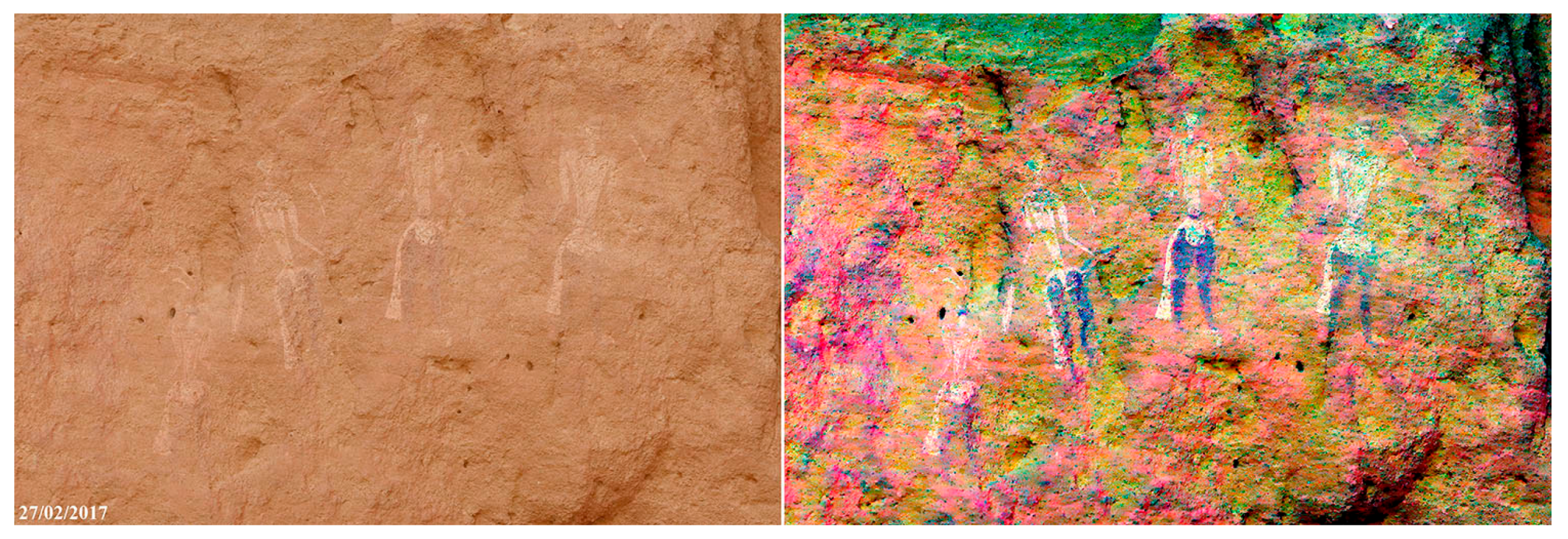
Figure 11.
Square motifs with appendages painted in solid white at P6 (Photo: Alessandro Menardi Noguera), likely representing animal skins (enhanced version to the right in DStretch LAB colour space).
Figure 11.
Square motifs with appendages painted in solid white at P6 (Photo: Alessandro Menardi Noguera), likely representing animal skins (enhanced version to the right in DStretch LAB colour space).

Figure 12.
White remains of cattle figures forming a large cluster of paintings at P7 (Photo: Alessandro Menardi Noguera). On the upper right, one isolated schematic giraffe is present (red ellipse).
Figure 12.
White remains of cattle figures forming a large cluster of paintings at P7 (Photo: Alessandro Menardi Noguera). On the upper right, one isolated schematic giraffe is present (red ellipse).

Figure 13.
Remains of bicolour cattle figures at 4.5 m above shelter floor at P8 (Photo: Alessandro Menardi Noguera). The enhanced version of the picture to the right shows a fragmentary figure of a warrior with a large round shield, right of the cattle figures (DStretch LDS colour space).
Figure 13.
Remains of bicolour cattle figures at 4.5 m above shelter floor at P8 (Photo: Alessandro Menardi Noguera). The enhanced version of the picture to the right shows a fragmentary figure of a warrior with a large round shield, right of the cattle figures (DStretch LDS colour space).
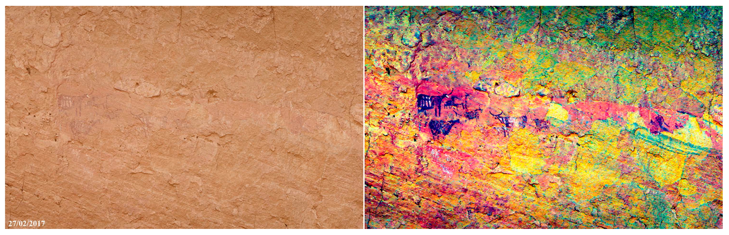
Figure 14.
Remains of white cattle figures on the western shelter sidewall, 5 m above the ground (P9). Two engraved cattle figures are present. The one to the right is deeply engraved and much worn; the one to the left is lightly engraved (Photo: Mauro Colella).
Figure 14.
Remains of white cattle figures on the western shelter sidewall, 5 m above the ground (P9). Two engraved cattle figures are present. The one to the right is deeply engraved and much worn; the one to the left is lightly engraved (Photo: Mauro Colella).

Figure 15.
Fragmentary engravings (E1 and E2 in Figure 4), decorated with an internal motif resembling a framework and patterns of angled lines (black and white version: interpretation by tracing, Photo: Alessandro Menardi Noguera).
Figure 15.
Fragmentary engravings (E1 and E2 in Figure 4), decorated with an internal motif resembling a framework and patterns of angled lines (black and white version: interpretation by tracing, Photo: Alessandro Menardi Noguera).
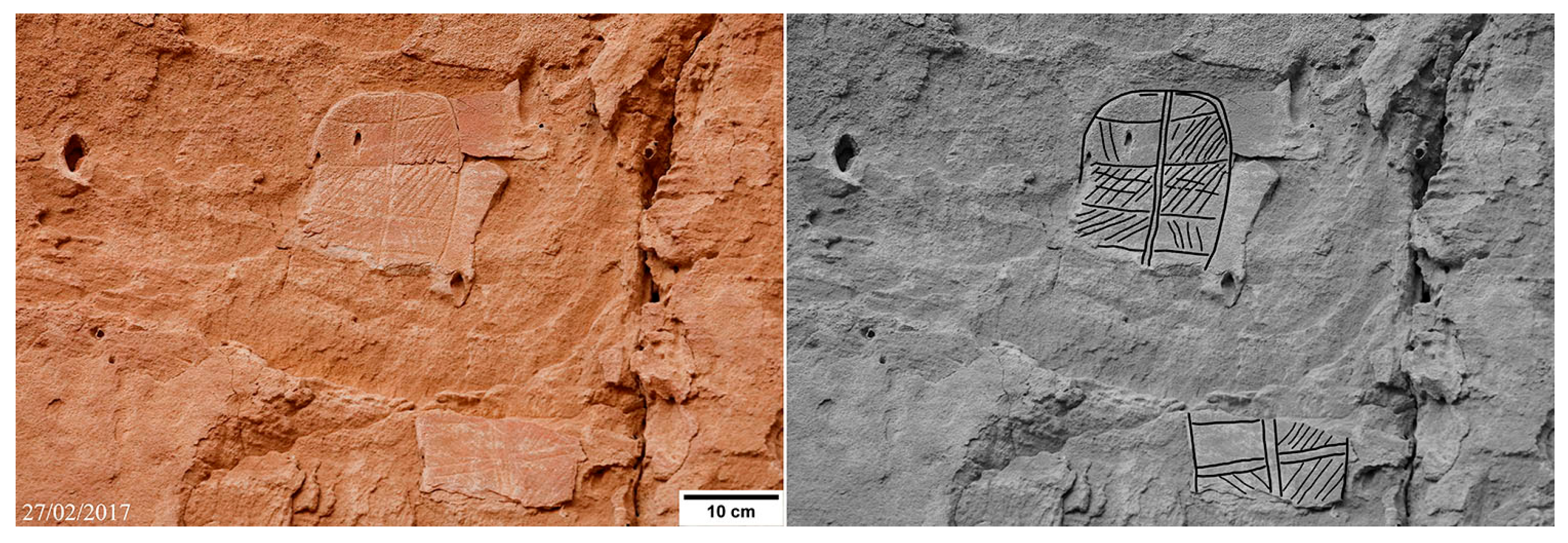
Figure 16.
Relics of a cluster of oval engravings (E3) with various internal elements and decorative patterns of lines (black and white version: interpretation by tracing, Photo: Alessandro Menardi Noguera).
Figure 16.
Relics of a cluster of oval engravings (E3) with various internal elements and decorative patterns of lines (black and white version: interpretation by tracing, Photo: Alessandro Menardi Noguera).

Figure 17.
Two paired oval engravings (E4), one with an internal graphic element recalling a framework, the other with a longitudinal element (black and white version: interpretation by tracing, Photo: Alessandro Menardi Noguera).
Figure 17.
Two paired oval engravings (E4), one with an internal graphic element recalling a framework, the other with a longitudinal element (black and white version: interpretation by tracing, Photo: Alessandro Menardi Noguera).
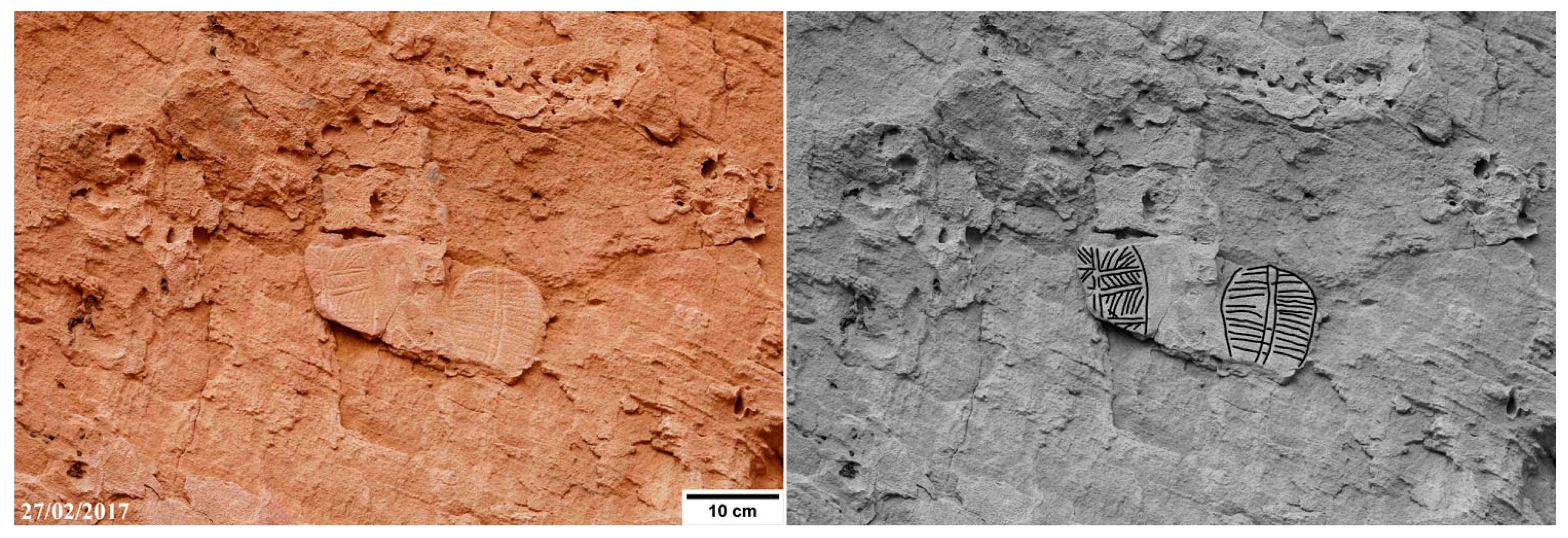
Figure 18.
A fragment of an oval engraving (E5) with a longitudinal element tapering in a rounded termination (black and white version: interpretation by tracing, Photo: Alessandro Menardi Noguera).
Figure 18.
A fragment of an oval engraving (E5) with a longitudinal element tapering in a rounded termination (black and white version: interpretation by tracing, Photo: Alessandro Menardi Noguera).

Figure 19.
An oval engraving (E6) preserved for its central portion only, internally decorated with horizontal stripes filled by angled grids (black and white version: interpretation by tracing, Photo: Alessandro Menardi Noguera).
Figure 19.
An oval engraving (E6) preserved for its central portion only, internally decorated with horizontal stripes filled by angled grids (black and white version: interpretation by tracing, Photo: Alessandro Menardi Noguera).
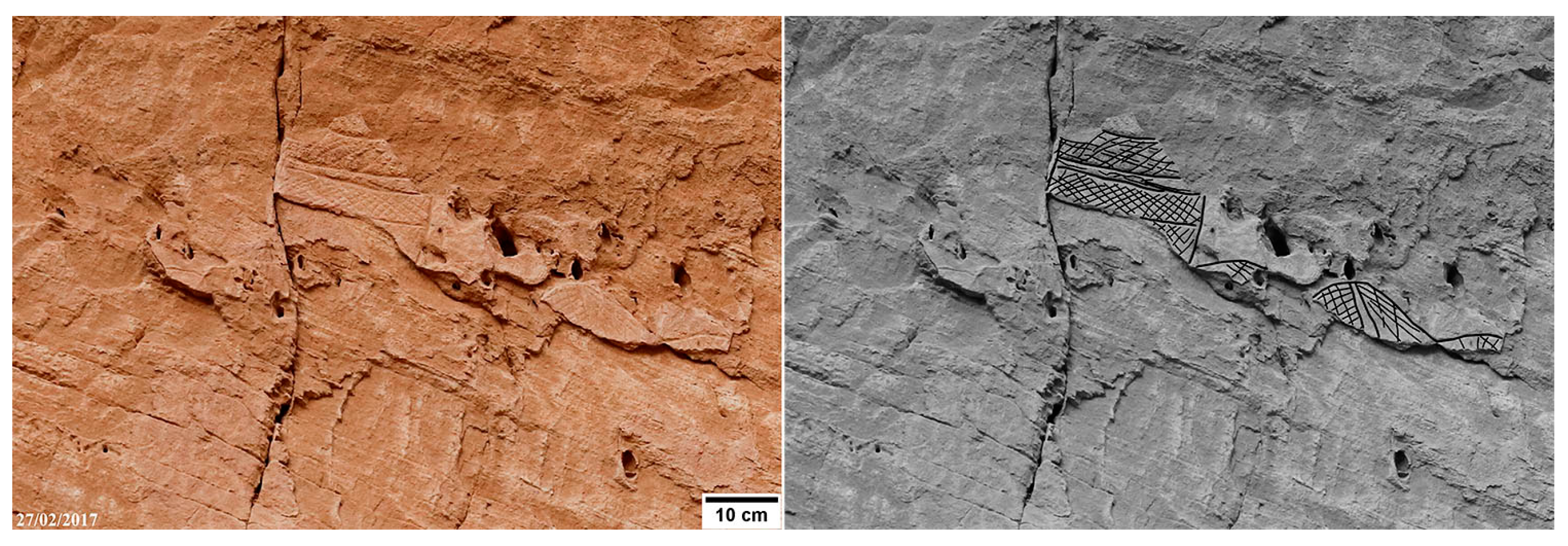
Figure 20.
Four oval engravings (E7); an irregular square grid decorates the one at the center (black and white version: interpretation by tracing, Photo: Alessandro Menardi Noguera).
Figure 20.
Four oval engravings (E7); an irregular square grid decorates the one at the center (black and white version: interpretation by tracing, Photo: Alessandro Menardi Noguera).

Figure 21.
Two overlapping oval engravings (E8); the one in the foreground is decorated with an angled grid (black and white version: interpretation by tracing, Photo: Alessandro Menardi Noguera).
Figure 21.
Two overlapping oval engravings (E8); the one in the foreground is decorated with an angled grid (black and white version: interpretation by tracing, Photo: Alessandro Menardi Noguera).

Figure 22.
An oval engraving internally decorated with various patterns of lines (black and white version: interpretation by tracing, Photo: Alessandro Menardi Noguera).
Figure 22.
An oval engraving internally decorated with various patterns of lines (black and white version: interpretation by tracing, Photo: Alessandro Menardi Noguera).

Figure 23.
Typological table compiled by redrawing selected petroglyphs published in the scientific literature, all executed by pecking. Petroglyphs from “a” to “d” are from the Anoa-1 site (redrawn from Choppy et al. (1996), courtesy of Bernard Choppy). Petroglyphs “e” to “f” are petroglyphs documented in a newly reported site in the western sector of the Ennedi (redrawn from a digital picture, courtesy of Stefan Kröpelin). Petroglyphs “g” and “h” are from the Azrenga site, located in the northern sector of the Ennedi (redrawn from Choppy et al. (1996), courtesy of Bernard Choppy). These ones, just two examples over the 61 present in the site, look analogous to the oval objects found in the Anoa area, “e” and “f,” but they are associated by proximity to sketchy animals, not to human depiction thus could represent also traps.

© 2017 by the author. Licensee MDPI, Basel, Switzerland. This article is an open access article distributed under the terms and conditions of the Creative Commons Attribution (CC BY) license (http://creativecommons.org/licenses/by/4.0/).
Share and Cite
MDPI and ACS Style
Menardi Noguera, A. The Oval Engravings of Nabara 2 (Ennedi, Chad). Arts 2017, 6, 16. https://doi.org/10.3390/arts6040016
AMA Style
Menardi Noguera A. The Oval Engravings of Nabara 2 (Ennedi, Chad). Arts. 2017; 6(4):16. https://doi.org/10.3390/arts6040016
Chicago/Turabian StyleMenardi Noguera, Alessandro. 2017. "The Oval Engravings of Nabara 2 (Ennedi, Chad)" Arts 6, no. 4: 16. https://doi.org/10.3390/arts6040016
Note that from the first issue of 2016, this journal uses article numbers instead of page numbers. See further details here.