Article

A Network Perspective of the Ecosystem’s Health Provision Spectrum in the Tourist Trails of UNESCO Global Geoparks: Santo Sepulcro and Riacho do Meio Trails, Araripe UGG (NE of Brazil)

by
Eduardo S. Guimarães
1,2,*,†,
Ronaldo C. D. Gabriel
3,†,
Artur A. Sá
4,5,†,
Rafael C. Soares
6,
Paulo Felipe R. Bandeira
7,
Isabella Hevily S. Torquato
8,
Helena Moreira
9,†,
Michel M. Marques
10 and
Jaqueliny R. S. Guimarães
11
1
Department of Sport Sciences, Exercise and Health, UTAD—University of Trás-os-Montes and Alto Douro, Quinta de Prados, 5000-801 Vila Real, Portugal
2
Department of Physical Education, URCA—Universidade Regional do Cariri, Araripe UNESCO Global Geopark, Geotourism and Territorial Development Sector, Rua Cel. Antônio Luiz 1161, Pimenta, Crato-CE 63105-000, Brazil
3
Department of Sport Sciences, Exercise and Health, Centre for the Research and Technology in Agro-Environmental and Biological Sciences (CITAB), University of Trás-os-Montes and Alto Douro, Quinta de Prados, 5000-801 Vila Real, Portugal
4
Department of Geology, UTAD—University of Trás-os-Montes and Alto Douro, Quinta de Prados, 5000-801 Vila Real, Portugal
5
Center for Geosciences, University of Coimbra, 3004-531 Coimbra, Portugal
6
Araripe UNESCO Global Geopark, Geoconservation Sector, Regional University of Cariri, Rua Carolino Sucupira, Pimenta, Crato-CE 63105-000, Brazil
7
Motor Evaluation Study, Application and Research Group—GEAPAM, URCA—Universidade Regional do Cariri, Rua Cel. Antônio Luís, 1161, Pimenta, Crato-CE 63105-000, Brazil
8
Department of Biology, URCA, Universidade Regional do Cariri, Rua Cel. Antônio Luís, 1161, Pimenta, Crato-CE 63105-000, Brazil
9
Department of Sport Sciences, Exercise and Health, Research Center in Sports Sciences, Health Sciences and Human Development (CIDESD) and Centre for the Research and Technology of Agro-Environmental and Biological Sciences (CITAB), University of Trás-os-Montes and Alto Douro, Quinta de Prados, 5000-801 Vila Real, Portugal
10
Department of Languages and Literatures, URCA—Universidade Regional do Cariri, Rua Cel. Antônio Luiz 1161, Pimenta, Crato-CE 63105-000, Brazil
11
Department of Nursing, URCA—Universidade Regional do Cariri, Rua Cel. Antônio Luiz 1161, Pimenta, Crato-CE 63105-000, Brazil
*
Author to whom correspondence should be addressed.
UNESCO Chair on “Geoparks, Sustainable Regional Development and Healthy Lifestyles”.
Geosciences 2021, 11(2), 61; https://doi.org/10.3390/geosciences11020061
Submission received: 30 October 2020 / Revised: 23 January 2021 / Accepted: 25 January 2021 / Published: 30 January 2021

Abstract

:
In this investigation, we formulated the Ecosystem’s Health Provision Spectrum and its centrality indicators, based on the identification of the Ecosystem Health Potentials and Opportunities on the trails of Santo Sepulcro and Riacho do Meio in the Araripe UNESCO Global Geopark (UGG), establishing a baseline for the promotion of green exercise and geotourism in the territory. Based on the network methodology for complex systems, we analyzed the closeness and strength of biotic, abiotic variables, nature phenomena, infrastructure, and sensory experiences in order to determine the configuration of these associations. In the Santo Sepulcro, regarding the association, two negative relations and two positive relations among the variables were highlighted; as for closeness and strength, Aquatic Diversity with the Scientific Values of Geodiversity stood out. In Riacho do Meio, we highlight three positive associations among the variables; as for connectivity, Biodiversity and Meteorological and Climate Exposure presented the highest values and, as for strength, the variables Biodiversity, Route Classification, and Aquatic Diversity were the most prominent. We conclude, based on the presented configuration, that the variables with greater connectivity act as hubs; if these variables are optimized, the network will present an acceptable theoretical configuration. However, neglecting central strength variables can cause the network to collapse.

1. Introduction

Motivated by the United Nations, hundreds of specialists in a significant global mobilization developed the scientific bases in the Millennium Ecosystem Assessment (between 2001 and 2005) with the purpose of evaluating the changes in the ecosystem and proposing the fundamental actions in the process of preservation of environmental services and sustainable development in order to ensure human well-being for future generations. From this important conceptual framework, significant advances have been made in the face of scientific production and discussion in political and social forums regarding the evident anthropocentric relationship of man/society to nature and the evident consequences of this unilateral trajectory worsening in the last century [1,2].
The assessment was based on the understanding of the link between ecosystems and their services to human well-being, as well as the interdependence and maintenance of this relationship in a long-lived and sustainable context [3].
In this global macro dimension, the impacts on the maintenance of an industrialized society increasingly require natural resources, and despite the advances, there is an evident distance between the more affluent countries and societies that consume more resources, when compared to the poorest countries and communities with access restricted to basic supplies for the subsistence of life, such as water and food, not to mention more complex advances such as access to health and education, which are fundamental supports to human dignity and the development of prosperous societies [4,5,6,7,8,9].
The conclusion of the Millennium Ecosystem Assessment was that ecosystem services are vital for human well-being and health, regardless of place or generation, and that this relationship has impacts and consequences on the condition and maintenance of supplies arising from nature [1,2,10]. Understanding this balance, developing a social conscience and a sustainable lifestyle on an ecological scale is the main way to guarantee the health of our planet for generations to come, as laid out and updated in the Sustainable Development Goals of Platform 2030 [11,12,13].
It is in this context that the United Nations Educational, Scientific, and Cultural Organization (UNESCO), for nearly five decades, has addressed initiatives and programs that seek sustainability in the relationship between man and nature, given the evident transformative capacity of societies and ecosystem resources [14,15,16].
Among the global scope proposal, we highlight the UNESCO Global Geoparks Program (UGGp) that promotes fruitful management strategies for the conservation of landscapes of rarity and scenic beauty and geosites of high scientific relevance, in addition to valuing the status quo of traditional communities and their cultural manifestations in this context [14,15,16,17,18,19].
The program currently involves 161 Global Geoparks in 44 countries, and its main mission is sustainable regional development based on safeguarding tangible and intangible heritage and promoting opportunities for stakeholders in the territory [20,21,22].
The Araripe UNESCO Global Geopark (UGG), which was founded in 2006, was the first UNESCO Geopark in the Americas and in 2020, it obtained its third greencard from the Global Geopark Network (GGN)/UNESCO. After 14 years, it is still the only geopark in Brazil and the main reference to the various projects in the continental country [23,24,25,26,27]. The relevance of its history in sustainable development in the Cariri Cearense region justifies scientific investigations in Araripe and with potential contribution to the other geoparks in the global UNESCO network [18,21,28,29].

The Ecosystem’s Health Provision Spectrum and the Green Exercise as a Healthy and Sustainable Strategy

Considering the context presented so far, despite the relevant contributions of researchers, government officials, and development agencies, it is emphasized that the advances in studies regarding the benefits of tangible services are much more expressive; after all, the need for humanity to provide water and food is unquestionable, and there is also a need for raw material such as minerals, wood, fiber, and substrates; areas for pasture and agriculture, among others [7,8,9,30,31,32].
However, regarding the intangible services of the ecosystem, it is necessary to reflect and contribute on the non-material supplies of the green spaces, as characterized in the scope of cultural services, where we can conceptualize them as those that provide salutary, recreational, aesthetic, and spiritual benefits from the multiplicity of cognitive interactions and associated with a sense of well-being and with a significant restorative effect [2,33,34,35,36,37].
Among the multiple possibilities of interactions between man and the ecosystem in the context of a healthy lifestyle, we highlight the opportunity for “green exercise”, which can be defined as physical activity, programmed or incidental, carried out in primitive, rustic, or designed natural areas and with significant sensory experience with the environment [18,38,39,40,41].
Several pieces of scientific evidence demonstrate the therapeutic, prophylactic, and human health properties in contact with green spaces. Therefore, these should be widely included in the development of public health policies related to urban inclusion and mobility and in order to increase green areas accessible to the population [28,29,33,35,36,37,41,42,43,44,45,46,47,48,49,50,51,52,53].
The geoparks territories, given their unique organization, naturalness, and scenic beauty, demonstrate enormous potential for green exercise and the practice of programmed physical activity (as an end) or incidental (as a means) [40,54].
In this light, the ecosystem’s health provision spectrum reflects both the potentials and opportunities existing in the environment and the various salutogenic benefits of exposure to these indicators by passers-by when traversing nature trails [40,54,55,56,57,58].
These interactions between man and ecosystem present different agents, such as aspects of geodiversity, biodiversity, and experience of well-being, among others; these interactions happen in different contexts, with different characteristics and with different levels of scale. The results of these interactions allow convergent interventions in multiple areas of knowledge. Systems with these characteristics are conceptualized as complex systems [59]. Thus, the measurement of complex systems can be performed from a network perspective, this analysis allows evaluating non-linear systems that are sensitive to initial conditions and with multiple interactions, such as the spectrum of health supply.
Therefore, the measurement of the ecosystem’s health provision spectrum from a network perspective can optimize the production of guiding bases in the identification of the characteristics of the different scenarios of the trails, and the indicators of the intangible supplies of this seek to add value in the offer of visiting experiences and as an alternative for health promotion arising from a healthy and sustainable lifestyle [3,18,60,61,62,63,64,65,66,67,68,69,70,71,72,73]. In this sense, the objectives of this investigation are to describe and associate in a network perspective the variables of the ecosystem’s health provision spectrum.

2. Materials and Methods

This was a documentary [74] and exploratory study with a transversal cut, quantitative approach to the data and developed on an ecological scale [75]. The universe of study was the UNESCO Global Network of Geoparks, and the locus was the trails of Riacho do Meio and Santo Sepulcro, both in Araripe UGG as a case study.
The common data were made available by Araripe UGG, which are the Trail Signaling Plan, Strategic Planning, the Master Plan, and periodic reports from the Geoconservation and Geotourism sectors. The complementary data were the speciesLink/CRIA data from Araripe Plateau and National Forest; the climatic and meteorological reports of Instituto Nacional de Meteorologia (National Institute of Meteorology, Brazil—INMET).
Field studies were carried out between January 2018 and June 2019 with the participation of a team composed of different specialists and with the support of local guides. The data were tabulated from spreadsheets prepared for this study and using georeferencing and audiovisual equipment and apps: GPS, smartphones, tablets, action cams, and digital cameras.

2.1. Inclusion Criteria and Study Locus—Riacho do Meio and Santo Sepulcro Trails

As for the inclusion criteria, we highlight that from the nine Araripe UGG geosites, five have natural trails as visitation attractions. These were stratified concerning their climatic characterization based on their location in the territory. In the second criterion, the trails were also considered based on the impact vulnerability parameter defined by Guimarães et al. (2018) [18]. Based on these criteria, we selected: (a) Riacho do Meio Trail (tropical humid/vulnerable); and (b) Santo Sepulcro Trail (semi-arid/non-vulnerable).
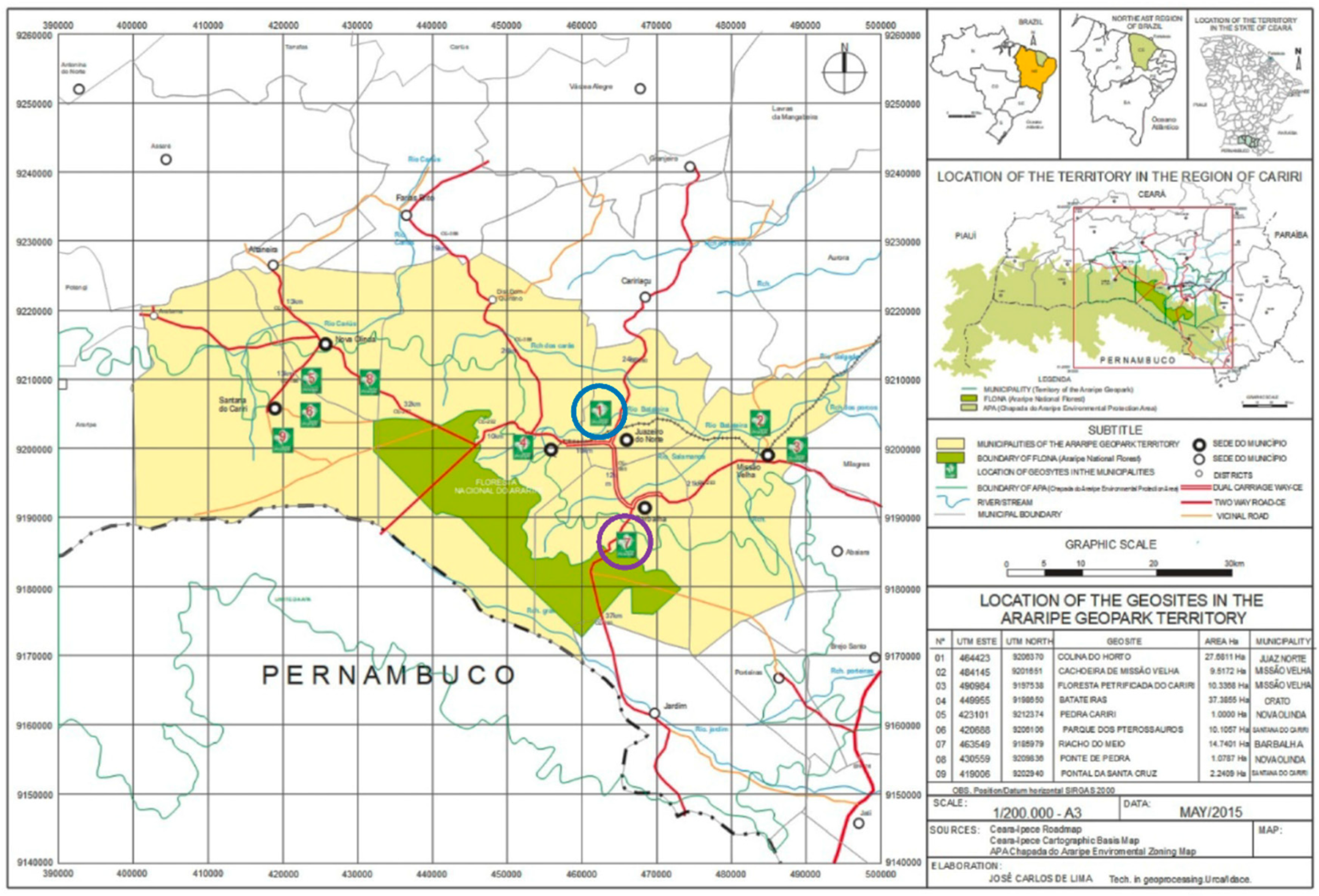
The Riacho do Meio trail (Riacho do Meio geosite) and the Santo Sepulcro trail (Colina do Horto geosite) are located in two geosites of Araripe Geopark, which is the scenario of this investigation. Araripe UGG is located in the Northeast of Brazil, in the extreme south of the State of Ceará, in the metropolitan region of Cariri Cearense, about 500 km from Fortaleza, capital of the State.
The territory of Araripe UGG was resized in the last UNESCO certification in 2019, presenting an area of 3789 km
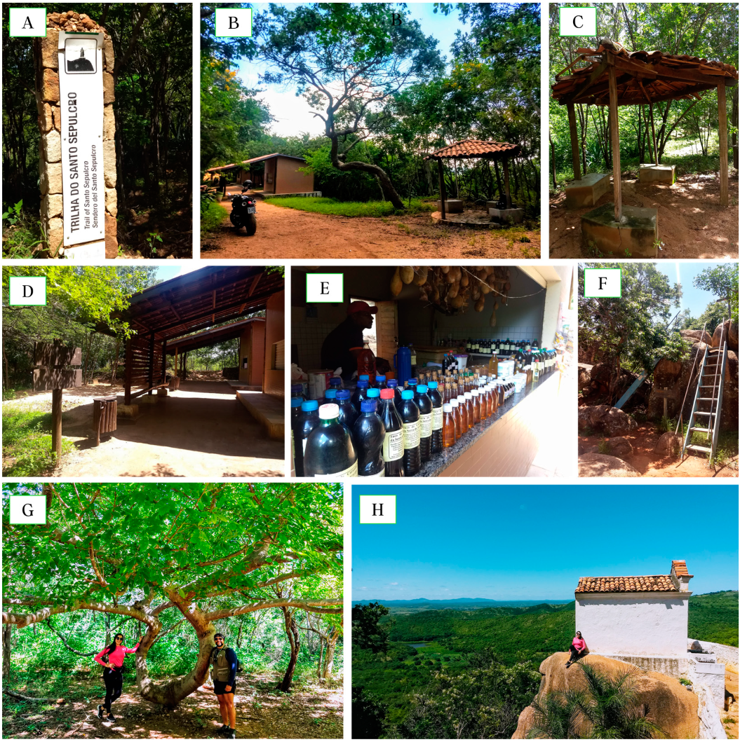
2 distributed over six municipalities: Crato, Juazeiro do Norte, Barbalha, Missão Velha, Nova Olinda, and Santana do Cariri. There are nine geosites in its territory, open to the public for visitation, with relevant geological, paleontological, archaeological, and historical content, combined with a valuable cultural heritage. These trails have notably significant potential for green exercise practicing [18,27,76,77] (see Figure 1).

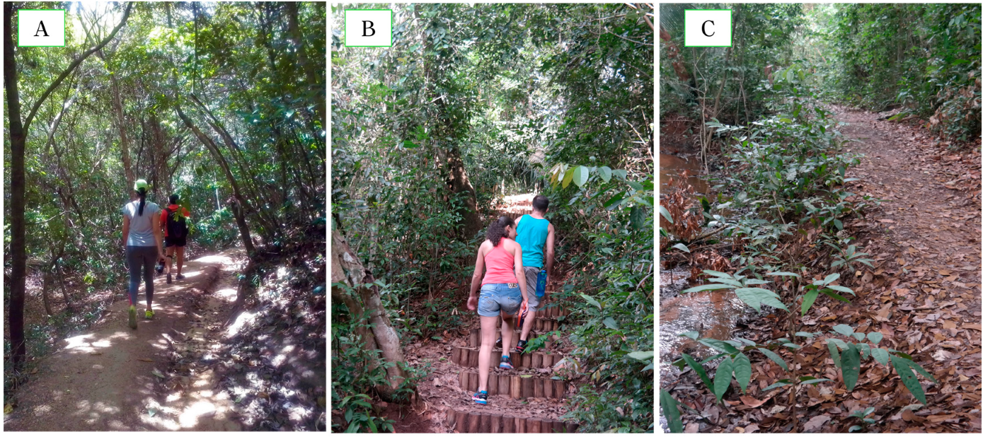
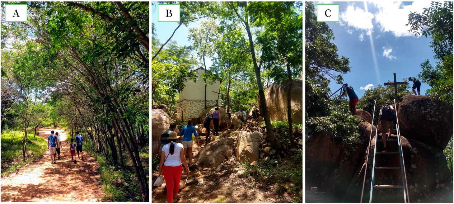
2.1.1. Riacho do Meio Trail

The Riacho do Meio trail, in the homonymous geosite (see Figure 2), is located 7 km from the city of Barbalha on the margins of the CE-060, under the coordinates 07°21′51″ south latitude and 39°19′49″ west longitude, at the foot of Araripe Plateau. The geosite where the investigated trail is located is inserted in two conservation units, one at the municipal level (city) and the other at the State level [18,77,78,79].
The trail is the main access to the attractions of the geosite, which receives around 3800 visitors a year from various ages and who seek especially bird watching and access to natural springs and water sources. The trail and the geosite appear in the critical second place in the Araripe UGG Management Priority and Visitation Impacts Matrix, which is mainly due to the absence of a permanent management team in the geosite [18].

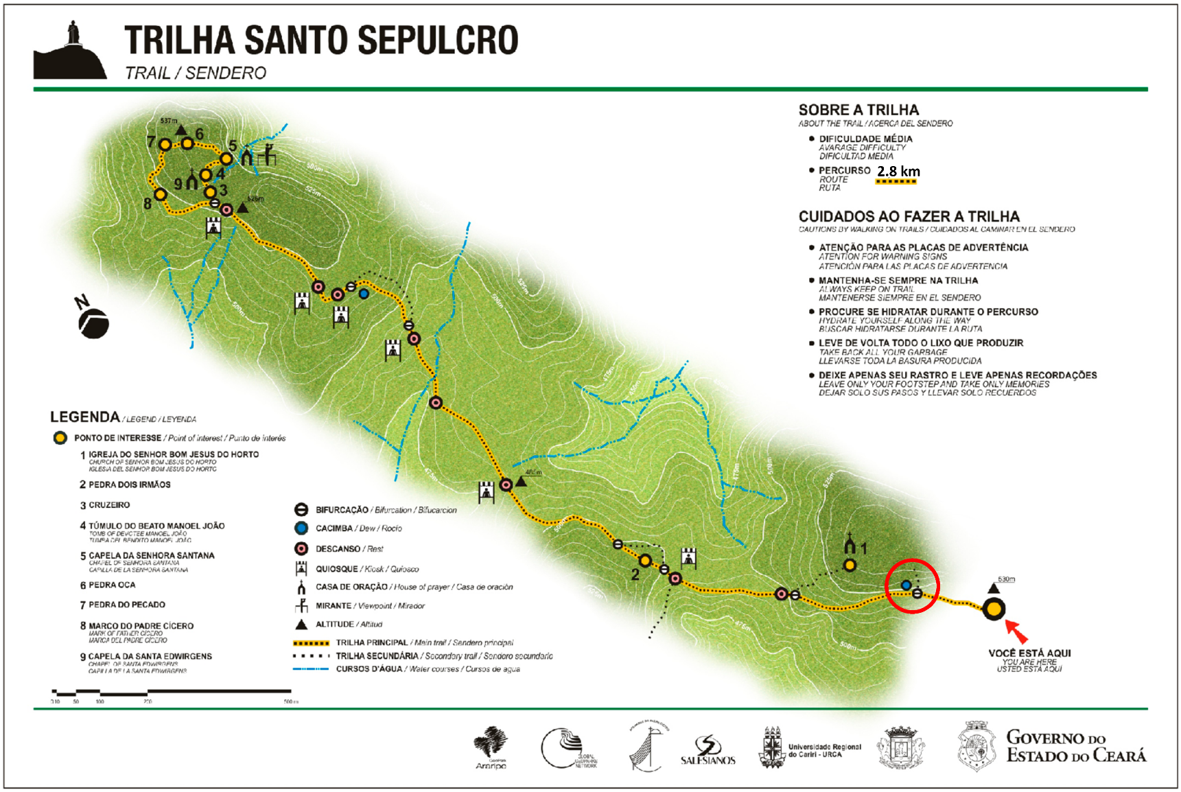
2.1.2. Santo Sepulcro Trail—Colina do Horto Geosite

The Santo Sepulcro trail at Colina do Horto geosite (see Figure 3) is located 3 km from the city center of Juazeiro do Norte, under the coordinates 07°10′47″ south latitude and 39°19′20″ west longitude. The geosite is one of the most visited spots in Cariri with more than 2.1 million visitors a year, especially on Christian festival dates, which is highlighted in pilgrimages and its devotees. It is a spiritual sanctuary with the famous statue of Father Cícero Romão Batista [18,80,81].
Thousands of people hike the Santo Sepulcro trail every year as an expression of faith, just as Father Cícero did; the trail has a strong cultural appeal and several monuments, chapels, and symbologies along the way. Despite the expressive number of visitors, the trail and the geosite appear among the best positions in the ranking of the Araripe UGG Management Priority and Visitation Impacts Matrix [18]; the low impact is attributed, despite the high demand for visitation, to the permanent presence of a management team in the geosite.

2.2. Analysis Instruments

For the collection and treatment of data diversity and its multidisciplinary specificities in this investigation, we consider methodologies and instruments already referenced and propose others contextualized to the object of this study.
In the light of the conceptual model proposed by Gabriel et al. (2018) [54] and in its materialization, the main contribution of this investigation is in the approach used in order to determine the indicators and their variables and in the treatment of data from the network methodology for complex systems [59,82]. In this sense, we stratified the analysis instruments into two subgroups in order to identify the Ecosystem Health Potential (EHP) and the Ecosystem Health Opportunity (EHO) as variables to determine the Ecosystem’s Health Provision Spectrum (EHPS) [54].

2.2.1. Analysis of Ecosystem Health Potential

In the Ecosystem Health Potential (EHP), we identified the propitious and beneficial configurations for physical and mental health in the natural areas of interest; therefore, five indicators were considered: (a) Geodiversity; (b) Biodiversity; (c) Climatic and Meteorological Diversity, (d) Aquatic Diversity; (e) Classification of Routes with emphasis on effort indexes [54].
The Geodiversity assessment was carried out using the System for the Registration and Quantification of Geosites and Geodiversity Sites—GEOSSIT [83], in order to define the risk of degradation, the tourist value (TVG), the educational value (EVG), and the scientific value of geodiversity (SVG) of geosites and their tracks in order to define their relevance in the global scenario. To assess the Biodiversity indicator (BIO), we used the Shannon–Weaver index to measure the diversity in categorical data from a base and, probabilistically, to define the diversity of the territory [84].
In the assessment of Climate and Meteorological Exposure (CME), we propose a psychometric scale model based on climatic and meteorological data published by INMET, where we cross the indicators to define the seasonal changes of the climate cycles in the region considering the impact on the vegetation of the trails and the exposure of passersby to climatic and meteorological conditions [85,86].
In Aquatic Diversity (AD), there are several factors to be considered for human attractiveness; however, in order to identify water as a health resource, we propose a psychometric scale model (0 to 3 scores) using as a reference Recreation Potential Indicator [87] and the degree of interactivity and experiences with nature [33] and tabulated the following indicators: (a) Availability (non-existent, inaccessible, seasonal, and perennial); (b) Type of Interaction (direct, indirect, diverse); (c) Bathing (regarding permission and recommendation); (d) Potability (if suitable for human and animal consumption; (e) Risk (possibility of risk situations and disasters).
For the Routes Classification (RC) and effort indices, we consider the model proposed by Associação Brasileira de Normas Técnicas (Brazilian Association of Technical Standards—ABNT) in Brazilian Standards (NBR) for Tourism with hiking activities and Classification of Trails (ABNT/NBR 15505-2: 2008) [88,89]. The standard is intended for the classification of hikes on a route without an overnight stay, adopting as a standard model, a non-athlete adult with light luggage. The classification is defined based on the estimated time for transposition of the route analyzing the severity of the environment, the orientation, the conditions of the ground, and the effort index. The horizontal travel time (Th) is the result of the distance covered in the section (Dp) divided by the estimated travel speed (Th = Dp/Vh) [88].

2.2.2. Analysis of Ecosystem Health Opportunities

To determine the Ecosystem Health Opportunities (EHO), two indicators are presented: (a) Infrastructure and (b) Well-Being Experiences with Nature [33]. These indicators are directly related to the management and offer of visitation attractions in the territory and in the area of interest, as well as the supplies regarding the conservation and sustainable use of natural heritage.
For the assessment of the support and accessibility infrastructure, we adapted the guiding model for the classification of the Visiting Zone and Management of the areas proposed by Guimarães et al. (2018) [18]. We assign the score based on a psychometric classification considering the conditions of the visitation zone as Ideal (3 scores), Limited (2 scores), or Fragile (1 score) and the Management profile as Active (3 scores), Responsive (2 scores), and Passive (1 score).
As for the Wellness Experience with nature (WE), in order to identify the non-material benefits of interactions with the ecosystem, we consider the conceptual model proposed by Russel et al. (2013) regarding the type and opportunity of sensory experience in visitation. As a reference for the WE database, we compiled the data to the lists on adventure tourism activities of the Ministry of Tourism of Brazil [90] and of Brazilian Association of Ecotourism and Adventure Tourism Companies (ABETA) [91].

2.3. Statistical Procedures

The possible relationships among the variables were calculated using a technique called network analysis, which is a machine learning technique used to measure systems with many variables, of different natures, from a graphic model. Network analysis advances in relation to more classic statistical models in understanding variables as a non-linear and complex system [82].
In the present study, we used the R package “qgraph” [82] to calculate and visualize the network graph. The “Fruchterman–Reingold” algorithm was applied so that the data were presented in the relative space in which variables with the strongest associations remain together, and the less strongly associated variables were repelled from each other [92]. We used the paired Markov random field model to improve the accuracy of the partial correlation network, which was estimated from the L1 regularized neighborhood regression. The less absolute contraction and selection operator was used to obtain regularization and make the model less sparse [93]. The EBIC (Extended Bayesian Information Criterion) parameter was adjusted to 0.5 to create a network with greater parsimony and specificity [94].
The interaction among variables (nodes) can be assessed under two aspects: (1) Closeness estimated from the number of times that a node is part of the shortest path among all other pairs of nodes connected to the network and (2) Strength, which is the sum of all the weights of the paths that connect a node to the others [82]. The positive relationships in the network are expressed by the blue color and the negative ones are expressed by the red color. The thickness of the graph indicates the weight (or association) of the proportion. The qgraph package of the Rstudio program was used to estimate and visualize the graphic.

3. Results and Discussions

3.1. Ecosystem Health Potential (EHP)

3.1.1. Geodiversity at Indicators of the Geosite Trails

Aspects of geodiversity were treated considering specific results for each corresponding trail (see Table 1). The trails of Santo Sepulcro and Riacho de Meio are inserted in geosites of national interest in scientific value (200–400), educational value (200–400), and tourist value (200–400). As for the risk of degradation, both fall into medium risk (200–300). In practice, the values are interrelated, although we can emphasize the scientific value in Figure 4A,E; the educational value in Figure 4B,D and the tourist value in Figure 4C,F.

3.1.2. Biodiversity at Indicators of the Geosite Trails

Araripe UGG has Araripe Plateau as a major landscape highlight, which is an area of extreme biological importance and environmental heterogeneity [77,95]. Considering this scenario, the results of the Shannon–Weaver index (H′) for the Riacho do Meio trail was 3.8 (see Figure 5A–C), whereas that for the Santo Sepulcro trail was 2.3. Generally, these indexes (H′) are between 1.5 and 3.5, rarely exceeding 5.5 [96] (see Figure 5D–F).

3.1.3. Aquatic Diversity at Indicators of the Geosite Trails

In the values of aquatic diversity, as seen in Table 2, we present the evaluated indicators, according to the proposal of this study, assuming the salutogenic effects of the interaction with water.
In the Santo Sepulcro trail, there is only the “Availability” indicator scored, being classified as “inaccessible” (1 score). In Riacho do Meio, “Availability” obtained the highest score “3” (perennial), and the lowest value in Balneability, “1” which is considered as “prohibited/inappropriate. The other values by indicator can be seen in Table 2.
In the Riacho do Meio trail, there are three springs and water sources, rustic pools, waterhole, streams, and paths [18,77,79]. As for the interaction, it is possible to hear the sound of water on practically the entire trail, in addition to the smell of wet earth near the springs. It is possible to get wet with the water in the springs and pools; however, bathing and entering the pools is not allowed. As for potability, some studies demonstrate variability in the analysis of water quality, indicating, in some analyses, the need for purification for consumption [97,98,99,100,101]. Regarding the risk, although rare, there are reports of occurrences of water runoff in the area, including warning signs placed; although unlikely, these signs should be considered mainly in the rainy season.
On the Santo Sepulcro trail, water is a practically unavailable natural resource. At the end of the trail, there is a spring of water on a stone, but it is not signposted and is also not accessible to visitors. In the viewpoints of the stones of the Senhora Santana chapel, it is possible to observe a distant dam that stands out in the middle of the forest; this bluespace is evident in the rainy season and characterizes its visual interaction in the evaluated environment.

3.1.4. Climate and Meteorological Characterization of Araripe UGG Territory and Implications

The analysis of the results of the meteorological and climatic variations of the Araripe UGG territory presented in Table 3 and in Figure 6 and Figure 7 shows that the months of December to July present the mildest indicators of exposure to bad weather. The periods are marked with the lowest accumulated insolation volume, the highest relative humidity rates, and the lowest incidence of winds.
Regarding temperatures, the period from February to July (25.4 to 24.4 °C) presents the lowest values in the region, with emphasis on the milder months from May to July below 24.7 °C. Precipitations present the highest rainfall volume between the months of January to April (190.9 to 188.5 mm), while the months of December and May, which precede and follow the rainy season, still show average rainfall in the period [86].
The periods of greatest exposure to extreme weather are between the months of August and November with the highest incidences of sunlight and the lowest relative humidity; the highest temperatures of the year are between September and December (26.7 to 27.4 °C); precipitation has the lowest rainfall volumes between the months of June and October, with an emphasis on the months of August and September due to the scarcity of rain (2.9 mm) and the highest wind rates, increasing the drought in the environment (see Figure 6 and Figure 7) [86].
Table 4 establishes the score and ranking of exposure and severity for the practice of physical activity on the investigated trails (from the mildest to the most extreme) and classifies the trails based on meteorological variables and seasonal climatic characterization of the territory [86,102].
Of the indicators present in Table 4, the “Green Tunnel” stands out, which was conceptualized in this investigation and characterized as areas with floors with biotic material (partial or total) of dry or humid soil, lawn, vegetation, or litter (leaves, branches, bark, fruits, etc.); green walls of trees, sub-shrubs and shrubs; green cover (roof) due to vegetation and tree tops (see Figure 8A,B) [103,104,105,106].
In this context, the Riacho do Meio trail had the highest total score with 50 scores. The indicators show that the trail is less influenced by climatic factors specifically because of the perennial green tunnels (rainforest), thus being characterized as a milder trail throughout the year for the practice of physical activity in different degrees of intensity.
The Santo Sepulcro trail, with 45 accumulated scores, has a strong seasonal influence due to the alteration of the caatinga vegetation (green tunnel) and all the dynamic landscape exposure conditions evident in cycle 3 and 4 from August to November, the driest period and most extreme exposure (see Table 4). The seasonal cycles from December to April (1st place, with 15 scores) and from May to July (2nd place, with 14 and 13 scores) stand out as the periods with the mildest climate for practicing hiking on the trails (among other physical activities). The periods from October to November (3rd place, 11 and 9 scores) and August and September (4th place, 8 and 9 scores) are the most extreme.
The analysis of the results of the meteorological indicators show that the periods from January to April are the most susceptible to high levels of relative humidity (RH) due to the greater precipitation in the period (see Figure 4). Considering that the territory is a warm region throughout the year, with average temperatures between 24 and 28 °C (see Table 3) and with peaks above 30 °C [107,108], we consider the indicators as absolute factors in the characterization of extreme and mild weather conditions throughout the year.

3.2. Ecosystem Health Opportunities (EHO)

3.2.1. Trails and Geosites Infrastructure

Riacho do Meio Trail and Geosite Riacho do Meio—Infrastructure

For the results regarding Infrastructure, Riacho do Meio geosite was classified with Limited Zone (2 scores) and Responsive Management (2 scores) obtaining 4 scores, which is equivalent to 66.7% of the total score [18].
This geosite has parking and a guardhouse (see Figure 9A) projected stone and wood trails (see Figure 9B), viewpoints, signaling, and internal communication (see Figure 9E,F), rest areas (see Figure 9H), anti-fauna waste baskets (see Figure 9G), rustic swimming pools (see Figure 9I), and springs with drinking water (see Figure 9J) and a relevant designed infrastructure, with restaurant and picnic lounge (see Figure 9C), auditorium (see Figure 9D), and bathrooms.
The geosite is on the edge of the CE-060 highway in front of residents’ houses and a small emporium; easy access is another important point, it is possible to access the geosite with public transport and taxis from the center of Barbalha. The mobile phone signal is variable with signal in parts of the track.

Santo Sepulcro Trail and Colina do Horto Geosite—Infrastructure

For Infrastructure results, the Santo Sepulcro trail and Colina do Horto geosite were classified with the Ideal Zone (3 scores) and Active Management (3 scores) totaling 6 scores, reaching the maximum expected score [18].
As it is a place of significant visitation, it is natural to find groups of hikers on the trail, especially on weekends and holidays. The trail allows visitors to hike through the Father Cicero’s path (see Figure 10A), visit Pedra do Pecado (Stone of the Sin), Pedra Oca (Hollow Stone), among others, in addition to the “magic trees” (see Figure 10G) and the various “miraculous” chapels (see Figure 10H) in his journey always associated with sacred figures and popular saints [77,109].
On the trail, there are seven support points selling regional products, water, coffee, and non-alcoholic drinks (see Figure 10B,D,E); there are kiosks with a rest area along the route (see Figure 10C) and viewpoints (see Figure 10F). The trail can be made without the support of accredited guides, yet, just like the trail of Riacho do Meio, guidance is recommended in order to optimize the experience. The best period to hike the trail is in the morning, just at dawn, especially in the dry season.
Easy access to the geosite is a relevant point. Public transport is available from the city center and from various points in other surrounding cities. It has extensive parking and services for taxis, motorbike taxis, and transportation by apps. The mobile phone signal generally works on practically the whole track.

3.2.2. Visiting Experience

As for the experience of well-being, the Riacho do Meio trail presents greater diversity in terms of biodiversity, and this is reflected in the greater potential for interaction justifying its 30 scores. Even so, the peculiarities in the experiments stand out, given the evident cultural and spiritual experience on the Santo Sepulcro trail and its 28 scores (see Table 5).

3.3. Characterization and Classification of Araripe UGG Trails—ABNT/NBR 15055.2

3.3.1. Characterization and Classification of the Riacho do Meio Trail, Geosite Riacho do Meio

I. Severity of the Environment: Severity received a 01 score, which was classified as “easy” (see Table 6). The route has sections of single track (one person at a time) limited by vegetation and streams (see Figure 11C, but without risk of falls); the green tunnels are perennial throughout the year due to the rainforest characteristic (see Figure 11A).
II. Directions on the Route: The orientation received a 01 score, which was classified as “easy” (see Table 6). The trail has good internal signs for guidance in addition to signs referring to geodiversity, biodiversity, cultural diversity, and environmental education signs.
III. Ground Conditions: The ground received a 02 score, which was classified as “moderate” (see Table 6). The main track of compacted sand will extend along the entire route (see Figure 11A), which is interspersed with wooden stairs suitable for hiking; however, it is limited for locomotion on wheels such as wheelchairs, baby carriages, or bicycles (see Figure 11B); Along the sand trails, several paths appear (see Figure 11C). The route has no technical requirements as long as you can hike without severe restrictions on mobility.
IV. Intensity of Effort: The trail received a 01 score, which was classified as “easy” (see Table 6). As for the distance, the main trail is 880 m, considering the route access and bifurcations, and the total route is around 2 km (round trip). During the trail, the positive slope was 169 m, and the negative slope of 124 m (see Figure 12). The average time to travel the route is 46 min. Considering the average of 30 min of stopping at cultural attractions, we have an accumulated total of approximately 1 h and 16 min. Based on these indicators, the stretch was classified as having little effort.

3.3.2. Characterization and Classification of the Santo Sepulcro Trail, Colina do Horto Geosite

I. Severity of the Environment: Severity received a 02 score, which was classified as “moderate” (see Table 6). The main adversity for hikers is related to exposure to climatic factors, alteration of seasonal vegetation, and the absence of water sources (highlighted in Section 3.1.3 and Section 3.1.4). At the end of the route, there is a circuit with rocky stretches and viewpoints where there is a risk of falls. The trail is located in an urban area, with frequent groups of hikers and the presence of local patrol.
II. Directions on the Route: There is an “Easy” level guidance with a 01 score in the classification. The route has good signage and internal communication for guidance and does not have complex bifurcations.
III. Ground Conditions: The indicator was classified as “without obstacles” and received a score of 02. As for the type of floor, most of the path is compacted earth; there are stretches with stone pavement and even floors with rocky surfaces (see Figure 13A,B). In the rocky circuit at the end of the trail, there is a need to use your hands to overcome obstacles, especially on the projected staircases and on the access rocks to the viewpoints, featuring sections such as vertical climbs without special material (see Figure 13C).
IV. Intensity of Effort: As for the distance, considering the official start of the trail at the first bifurcation (highlighted red circle in Figure 3), the Santo Sepulcro trail is 2.1 km long and a 400 m stretch in circuit at its end; the total route is around 5 km (round trip). During the trail, the positive slope was 56.2 m and the negative slope was 46.1 m (see Figure 14). The average time to travel the route is 1 h and 45 min. Considering about 45 min of accumulated stop at cultural attractions and contemplation of the landscape, we have the total, for transposition of the trail, of approximately 2 h 30 min; based on these indicators, the stretch was classified as “moderate effort” obtaining 02 scores in the effort index classification (see Table 6).
Based on the psychometric classification of the indicators, we attribute the results in Table 6.

3.4. Association—Ecosystem’s Health Provision Spectrum

3.4.1. Network Perspective: Ecosystem’s Health Provision Spectrum

The data of the discriminating prevalence indicators presented in Table 7, in the comparative analysis between the trails, were used as the base date and fed the primary matrix for analysis in networks. However, indicators without statistical variability and discrimination among values were disregarded in this analysis. It should be noted that both the reference sample values and the cases are not absolute and should be readjusted based on the characteristics of the assessed territory.

3.4.2. Association Matrix of Ecosystem’s Health Provision Spectrum of the Araripe UGG Trails

The Association Matrix, shown in Table 8, expresses the results of positive and negative relationships among variables. We highlight in the results and discussions the positive relations above 0.23 and the negative ones above −0.23.

Network Analysis Ecosystem’s Health Provision Spectrum of the Santo Sepulcro Trail

Figure 15 shows the network of Santo Sepulcro trail in Colina do Horto geosite. In the main results, we highlight the negative relations of Touristic Value of Geodiversity (TVG) with Aquatic Diversity (AD, −0.45) and Scientific Value of Geodiversity (SVG) with TVG, (−0.23). Furthermore, the positive relationships of AD with the variables SVG (0.47) and Biodiversity (BIO, 0.39) (see Table 8).

Network Analysis Ecosystem’s Health Provision Spectrum of the Riacho do Meio Trail

In the network configuration in Figure 16 of the Riacho do Meio trail, the main associations were found between the variables Biodiversity (BIO) and Climatic and Meteorological Exposure (CME, 0.29), Route Classification (RC) and Wellness Experience (WE, 0.37), and Scientific Value of Geodiversity (SVG) and Aquatic Diversity (AD, 0.35), all of which were positive. The weight of the other associations of the two geosites can be seen in Table 8.

3.4.3. Centrality Indicators: Closeness and Strength

In order to optimize the territory management process, based on the results of the network, the observance is highlighted especially in the connectivity and strength indicators (centrality indicators) presented by the variables in Figure 17.

4. Discussions

This investigation, along its methodological trajectory, proposed characterizing, from the perspective of networks, the Ecosystem’s Health Provision Spectrum on the identification of the health potential and opportunities of the ecosystem on the trails of Santo Sepulcro and Riacho do Meio in Araripe UGG, establishing a baseline for several purposes, among them, the promotion of healthy lifestyle and geotourism in the territory.
As for the results of biodiversity, limitations are highlighted regarding the estimate of diversity on the trails. More detailed field studies, with standardization of the sampling effort, are urgently needed to get a better understanding of the biodiversity of the Araripe UGG territory, especially of its geosites.
Regarding the meteorological and climatic exposure of the trails, given the ecological nature of this investigation, we consider the seasonal characteristics of the territory’s climate and vegetation given its correlation in the potential microclimate of the trails and in the exposure to bad weather. The climatic results of a territory, despite being classified in their own dimension, can be suitable for other territories, especially those with characteristics similar to Araripe. The results of the meteorological and climatic indicators of the Araripe territory can be used for several purposes, including health benefits from outdoor physical practice.
Based on the results presented and in the context of the review referenced in this study, it should be noted that in relation to meteorological and climatic indicators, environments with central values are less stressful risk factors for organic homeostasis when compared to extreme values that tend to overload the cycle of body thermoregulation, especially in situations of overload and effort, as in enduring physical activities [102,110,111,112,113].
As for outdoor areas, the characteristics of green environments, especially with the presence of green tunnels, as proposed in this study, are configured as a factor of climatic and meteorological protection to passers-by exposed to incidental or programmed physical practice, thus optimizing the benefits of the endured physical activity [102,104,105,106,113,114].
The climatic and meteorological indicators in the territory of Araripe are relevant data regarding the seasonal exposure of hikers on the trails and also to consider other physical activities of greater overload such as trail running and mountain biking, which are very popular sports in the region. Such results are shown as an important tool for professionals in the sport, education, and health areas, tourism guides, and other professionals in the tourist trade, among others.
The on-site analysis of weather conditions and the feeling of thermal comfort [107,113,115,116,117,118,119,120,121] and microclimates on the trails were not investigated in this study. Therefore, understanding the limitation of the nature of this investigation and the contribution of the results with more specificity, we recommend the relevance of these data in future investigations.
As for aquatic diversity, the synthesis of the results on the possibilities of interaction with water and its salutogenic effects presented in this study sought to objectively translate this condition as a positive factor for the well-being of hikers. In this sense, we recommend that the local infrastructure, as an opportunity for the health of the ecosystem, should adopt strategies to provide the resource for the consumption of passers-by.
As for attractions, infrastructure, and provisions, the investigated trails demonstrated landscapes of relevant added value in the historical and cultural context.
The Santo Sepulcro trail is an example where it is impossible to disassociate material and immaterial heritage, such as their relevance as a geomorphological representation of magmatic rocks and cultural expression evident on the route. The trail, surrounded by caatinga vegetation, tells the teachings of Father Cícero; it is filled with stones with “magical” attributes and chapels with sacred figures sculpted and built in the rocks that give the place a transcendental experience. The Santo Sepulcro trail and Colina do Horto geosite have the best support infrastructure and experience for visitors, which is classified with high demand for visits and low impact [18].
The Riacho do Meio trail is still an underutilized area due to the permanent absence of a management team; the place is classified as a priority in terms of the management of visitation impacts [18]. Even so, the geosite and its trails have a high score in terms of biodiversity, projected structure, contact with springs, and perennial water sources in addition to leafy vegetation all year round.
Regarding the classification of routes based on NBR-15055.2, it is noteworthy that the results of the investigated conditions generate relevant information about the trails as a tourist product and standardized by the Brazilian consumer protection code [89,122,123]. It should also be noted that the trails are the most important means of accessing the health provisions of the ecosystem and geosites visitation.
Both trails showed mild conditions, given the indicators classified between 1 and 2 scores (out of 5 most extreme), showing themselves as alternatives and aggregating visitation experiences for different audiences and with different interests from contemplation to nature to the exercise of faith and spirituality, all passing through the hike as a means of access and the various benefits of this physical practice.
In order to optimize the specificities regarding physical overload, as recommended by Gabriel et al. (2018), it is recommended to analyze biomechanical and physiological variables regarding the effort during the transposition in order to establish more detailed indicators for the different types of hikers. In this sense, future investigations with this purpose are suggested, given the need for more discriminating data in addition to the analysis of the effort index of the ABNT/NBR 15055.2 model used in this investigation.

4.1. Network Perspective of the Ecosystem’s Health Provision Spectrum of the Santo Sepulcro Trail

On the Santo Sepulcro trail, the positive association (0.47) between Scientific Value of Geodiversity (SVG) and Aquatic Diversity (AD) translates into the sense that the processes that value geological events, from a scientific point of view, can occur both in abundance and in scarcity of water. In the case of the trail in question, the geological characterization and scientific valuation processes of the theme have an important relationship with the scarcity of water, which is largely caused by these characterizations [77].
In turn, it is possible to observe a negative association (−0.45) between Touristic Value of Geodiversity (TVG) and Aquatic Diversity (AD), which reinforces the association of water scarcity with the geological aspects that justify the existence of geotouristic values in the place, representing, therefore, an inverse relationship [77]. Likewise, we note the negative association (−0.23) between Scientific Value of Geodiversity (SVG) and Touristic Value of Geodiversity, which is intrinsic to the fact that the latter develops mostly due to historical and cultural aspects. Thus, it is necessary to reframe the geological aspects by inserting them in the historical–cultural contexts, in order to modify this association between the indicators [21] (see Table 6).
Still on the Santo Sepulcro trail, the evident association of Biodiversity (BIO) with Aquatic Diversity (AD) represents the intimate interdependence in the construction of the landscape and the semi-arid trail, which explains the seasonality of the milder or more rigorous exposure depending on the green tunnels along the route, given the remarkable presence of xerophilous species—that is, vegetation well adapted to live in dry environments, as is the case of the geosite.
It should be noted that the Aquatic Diversity indicator on the Santo Sepulcro trail received a single score, because it is only possible to see a bluespace of the viewpoints at the end of the trail, this being a practically inaccessible resource.

4.2. Network Perspective of the Ecosystem’s Health Provision Spectrum of the Riacho do Meio Trail

On the Riacho do Meio trail, the main associations were found among the variables Biodiversity (BIO) and Climatic and Meteorological Exposure (CME) 0.29; Route Classification (RC) and Wellness Experience (WE) 0.37; and Scientific Value of Geodiversity (SVG) and Aquatic Diversity (AD) 0.35, all of which were positive (see Table 6).
The environmental conditions of the green tunnels of the Riacho do Meio trail, with denser vegetation and partially vegetated soils due to the humid forest present on the trail, reflect less radiation and reduce exposure to other indicators, presenting a milder environment, which contributes in the process of human thermoregulation during physical effort and in the comfortable experience of well-being in the transposition of the trail [103,104,105,106,110,111,124,125], as shown in the strong connection between the variables Route Classification and Wellness Experience.
The strong association between Scientific Value of Geodiversity and Aquatic Diversity highlights the importance of geological knowledge and geodiversity [126] in the development of a sub-humid environment with differentiated vegetation and the occurrence of crystalline water sources in the general context of the semi-arid region.
In this sense, we recommend, for the optimization of the Ecosystem’s Health Provision Spectrum, the commitment to management and actions that strengthen the link of geodiversity with the local fauna and flora, as well as with the occurrence of springs [77,78]. Therefore, we note all the interdependence and integrality among geodiversity, biodiversity, and aquatic diversity [79] demonstrated in the network of this study.

4.3. Centrality Indicators

Based on the results presented for the network, the variables with the highest closeness act as hubs; if these variables are optimized, the network will present an acceptable theoretical configuration. In this way, centrality indicators are useful to guide where managers should prioritize their actions. In a practical context, neglecting central variables, as pillars (or nodes) of the network’s support, potentially means leading to a breakdown in the relationship of the variables presented before.
In the Santo Sepulcro trail, Aquatic Diversity (AD) and Scientific Value of Geodiversity (SVG) had the highest scores in the indicators of closeness and strength. The high connectivity of Aquatic Diversity is explained by the fact that the presence of water is a positive factor for natural areas, especially those with tourist potential [78]. Therefore, we suggest, in the case of tourist trails, availability and infrastructure adjustments such as wells, fountains, or drinking fountains for places that do not have the supply of water for human consumption (as in the Santo Sepulcro trail) as well as periodic studies and analyses regarding the bathing and potability of water as in the case of the Riacho do Meio trail.
Investing in Scientific Value of Geodiversity (SVG) strategies would imply ensuring the preservation of relevant outcrops and the popularization of geological knowledge with visitors [26]. This reinforces the need for investments in geo-educational communication that are more didactic and accessible to the general public and not just with technical–scientific emphasis, as it is provided in the geosite [26], and that was highlighted by the UNESCO/GGN evaluators in the revalidation of the green seal in 2019.
In Riacho do Meio, Biodiversity (BIO) and Climatic and Meteorological Exposure (CME) presented the highest closeness values. In the strength indicator, the variables Biodiversity, Route Classification (RC), and Aquatic Diversity (AD) have the highest values.
Observing the high closeness of Biodiversity and Climatic and Meteorological Exposure, the importance of preserving and maintaining native vegetation is highlighted, which has a direct influence on the relative humidity of the air, on the ambient temperature due to the dissipation of heat by conduction (from the ground), in radiation due to exposure to sunlight (insolation), and also the influence on drafts (winds) and heat exchange by convection, creating milder microclimates and consequently a more pleasant and aggregating sensory and well-being experience to different audiences [103,104,105,106,110,111,124,125].
The priority of management actions in the central variables ensures that the strongest and most determinant indicators that characterize the assessed area are maintained or endured, giving time for decision making on indicators that can be gradually improved.

5. Conclusions

This study in question, in the materialization of the proposed conceptual model, sought to contribute with guiding and resolute approaches of applicability, both in geopark territories and in natural and related areas, with the purpose of optimizing the sustainable management of resources and health potentials of natural trails.
The Araripe UGG territory and the generations over time present their own narratives with different experiences and that lead the visitor to see, hear, and feel the aromas and finally, interact with the environment. This multisensory experience brings us closer to nature and its stories; when stepping on the territory, we can also become part of it.
The biggest challenge of this investigation, besides establishing isolated indicators, was the composition of these in the reading of the nuances of the territory and in the context of health and healthy lifestyle, based on the non-linear assessment of complex systems translating the holistic concept, which, although fundamental, proves difficult to actually measure and interpret.
The Ecosystem’s Health Provision Spectrum represents a purposeful action in order to develop new methodologies for integral assessment of the environment, with particular regard to geoparks and natural areas. The idea is to materialize results with a holistic, interdisciplinary, and associative approach, following this trend of the UNESCO Global Geoparks Program and getting closer, in fact, to its complex praxis.
The identification of the health resources of the trails demonstrated the need for multiple interpretations in order to answer how much access to biotic and abiotic elements, as well as the dimensioning of the forces of nature, intangible heritage, experiences of well-being and management can contribute to the physical, mental, and spiritual health of the subjects exposed to them.
Considering also the resilience of the human being to face extreme conditions, we understand that the characterization of a trail or territory generates information about the confrontation and the challenge to be overcome. Therefore, it is not the intention of this investigation to categorize milder environments as better and more extreme as worse; this type of classification tends to stigmatize territories as less recommended or indicated and to overestimate territories considered ideal. The UNESCO Geoparks Program, in its concept, highlights unique territories and experiences; it is up to the visitor to choose his challenge. Extreme achievements generate unique experiences, remarkable memories, and spectacular stories.
The results of this investigation, given its quantitative approach and network analysis, sought to propose an instrument that presents relevant potential for replication among the various UNESCO geopark territories and related areas, in order to generate relevant data for optimized management.
Still, not everything can be quantified; when traveling a trail in Araripe and its territory, it is necessary to know that the past is relived when experiencing a part of its stories, tales, and its relevant intangible and immeasurable heritage. It is this uniqueness, in the charm of each visitor’s experience, that truly identifies a geopark in the one who is there.
There are narratives of time, land, and people in their multifaceted and inseparable context. Tales, old and new, fulfill their role by enchanting the stories of an enchanted land, for that, a good storyteller is enough.

Author Contributions

All authors contributed to this manuscript: The principal researcher, E.S.G., contributed substantially to the development and application of the scientific plan for this research, which is based on his doctoral thesis, currently under development. The critical analysis of the literature review, discussions, and methodological guidelines were contributions from R.C.D.G. and H.M. Researcher A.A.S. contributed to the review of the UGGp conceptual, theoretical and technical framework. The review of statistical analysis and the proposed mathematical model were carried out by researchers P.F.R.B. and E.S.G. The researcher R.C.S. contributed to the revision of the reference in geoconservation and measurement in the context of Geoparks. Researcher I.H.S.T. contributed to the review of the reference on biodiversity and measurement of the evaluated areas. The researcher M.M.M. contributed to orthographic, linguistic and technical revision. Researcher J.R.S.G. contributed to the theoretical and methodological review of studies on human health and the formatting in the rules of this article. All authors have read and agreed to the published version of the manuscript.

Funding

This research received no external funding.

Institutional Review Board Statement

Not applicable.

Informed Consent Statement

Not applicable.

Data Availability Statement

Not applicable.

Acknowledgments

This research it is a part of the PhD studies in Sports Sciences by the E.S.G. author, which are supported by the UNESCO Chair of “Geoparks, Sustainable Regional Development and Healthy Lifestyles” financed by the European Investment Funds FEDER/COMPETE/POCI—Competitiveness Operational Program and Internationalization, within the scope of Project POCI-01-0145-FEDER-006958 and National Funds of FCT—Portuguese Foundation for Science and Technology, within the scope of Project UID/AGR/04033/2013 and the under projects UID04045/2020 and UIDB/04033/2020. We would also like to thank the Secretaria da Ciência, Tecnologia e Educação Superior do Estado do Ceará/Brazil (SECITECE); The Fundação Cearense de Apoio ao Desenvolvimento Científico e Tecnológico (FUNCAP) specified in process nº. 08931709/2019; the Rectory of the Regional University of Cariri (URCA) and the Araripe UNESCO Global Geopark for supporting this research. We also thank the collaboration of Artur Ribeiro and Edson Neto, guides and partners of Estação Turismo de Barbalha, to Irapuã, local guide of the Riacho do Meio community, to Biologist José Weverton de Almeida from URCA; to Francisca Maria de Santana, manager of the Salesiano Foundation in Colina do Horto; to Allysson P. Pinheiro, director of the Plácido Cidade Nuvens Museum of Paleontology/URCA; to Luiza de Almeida Oliveira Guimarães for her collaborations in revising the translation and to Caio Casanova C. Simão for her collaborations in editing the figures.

Conflicts of Interest

The authors declare no conflict of interest.

References

  1. Carpenter, S.R.; Mooney, H.A.; Agard, J.; Capistrano, D.; DeFries, R.S.; Díaz, S.; Dietz, T.; Duraiappah, A.K.; Oteng-Yeboah, A.; Pereira, H.M. Science for managing ecosystem services: Beyond the Millennium Ecosystem Assessment. Proc. Natl. Acad. Sci. USA 2009, 106, 1305–1312. [Google Scholar] [CrossRef] [PubMed] [Green Version]
  2. Organização Pan-Americana de Saúde. Enfoques Ecossistêmicos Em Saúde: Perspectivas Para sua adoção no Brasil e países da América Latina; Organização Pan-Americana da Saúde Brasília: Brasília, Brasil, 2009; p. 44. [Google Scholar]
  3. Gordon, J.E. Geoheritage, geotourism and the cultural landscape: Enhancing the visitor experience and promoting geoconservation. Geosciences 2018, 8, 136. [Google Scholar] [CrossRef] [Green Version]
  4. Martine, G.; Alves, J.E.D. Economia, sociedade e meio ambiente no século 21: Tripé ou trilema da sustentabilidade? Rev. Bras. Estud. Popul. 2015, 32, 433–460. [Google Scholar] [CrossRef]
  5. Schappo, S. Josué de Castro e a agricultura de sustentação em Geografia da fome. Sociologias 2014, 16, 306–338. [Google Scholar] [CrossRef] [Green Version]
  6. Sachs, I. Desenvolvimento sustentável: Desafio do século XXI. Ambiente Soc. 2004, 7, 214–216. [Google Scholar] [CrossRef] [Green Version]
  7. Organização das Nações Unidas. O Futuro que Queremos; Documento final da Conferência Rio+ 20, versão em espanhol; Organização das Nações Unidas: Rio de Janeiro, Brazil, 2012; p. 59. [Google Scholar]
  8. Hoff, H.; Nykvist, B.; Carson, M. “Living well, within the limits of our planet”? Measuring Europe’s growing external footprint. Stockh. Environ. Inst. 2014, 2014, 5. [Google Scholar]
  9. Ostrom, E. Governing the Commons: The Evolution of Institutions for Colletive Action; Cambridge university press: Cambridge, UK, 2015; p. 271. [Google Scholar]
  10. Reid, W.; Mooney, H.; Cropper, A.; Capistrano, D.; Carpenter, S.; Chopra, K.; Dasgupta, P.; Dietz, T.; Duraiappah, A.; Hassan, R. Millennium Ecosystem Assessment Synthesis Report. Pre-publication. Final Draft Approved by MA Board on 23 March 2005. A Report of the Millennium Ecosystem Assessment. 2005. Available online: https://www.osti.gov/etdeweb/biblio/20581845 (accessed on 6 December 2018).
  11. Ranängen, H.; Cöster, M.; Isaksson, R.; Garvare, R. From global goals and planetary boundaries to public governance—a framework for prioritizing organizational sustainability activities. Sustainability 2018, 10, 2741. [Google Scholar] [CrossRef] [Green Version]
  12. Franco, I.B.; Chatterji, T.; Derbyshire, E.; Tracey, J. Actioning the Global Goals for Local Impact; Springer: Berlin, Germany, 2019. [Google Scholar]
  13. Rosado-González, E.M.; Sá, A.A.; Palacio-Prieto, J.L. UNESCO Global Geoparks in Latin America and the Caribbean, and Their Contribution to Agenda 2030 Sustainable Development Goals. Geoheritage 2020, 12, 1–15. [Google Scholar] [CrossRef]
  14. Organização das Nações Unidas para a Educação, a Ciência e a Cultura. Celebrating Earth Heritage, Sustaining local Communities; United Nations Educational, Scientific and Cultural Organization: Paris, France, 2016. [Google Scholar]
  15. Organização das Nações Unidas para a Educação, a Ciência e a Cultura. The Operational Guidelines for the Implementation of the World Heritage Convention. Available online: https://whc.unesco.org/en/guidelines/ (accessed on 4 April 2018).
  16. Bortolotto, C. UNESCO, cultural heritage, and outstanding universal value: Value-based analyses of the World Heritage and Intangible Cultural Heritage Conventions. Int. J. Herit. Stud. 2015, 21, 528–530. [Google Scholar] [CrossRef]
  17. Organização das Nações Unidas para a Educação, a Ciência e a Cultura. World Network of Biosphere Reserves (WNBR). Available online: http://www.unesco.org/new/en/natural-sciences/environment/ecological-sciences/biosphere-reserves/world-network-wnbr/ (accessed on 12 April 2018).
  18. Guimarães, E.; Sá, A.; Gabriel, R.; Moreira, H.; Guimarães, J.; Bandeira, P.; Silva, J.; Soares, R.; Melo, J. Matrix of Priorities for the Management of Visitation Impacts on the Geosites of Araripe UNESCO Global Geopark (NE Brazil). Geoscience 2018, 8, 199. [Google Scholar] [CrossRef] [Green Version]
  19. Brilha, J. Inventory and quantitative assessment of geosites and geodiversity sites: A review. Geoheritage 2016, 8, 119–134. [Google Scholar] [CrossRef] [Green Version]
  20. Organização das Nações Unidas para a Educação, a Ciência e a Cultura. Global Geopark Program. Available online: http://www.unesco.org/new/en/natural-sciences/environment/earth-sciences/unesco-global-geoparks/list-of-unesco-global-geoparks/ (accessed on 29 August 2020).
  21. Soares, R.C.D.; Lopes, W.F.; Oliveira, L.S.; Guimarães, E.S. Geotourism in Araripe UNESCO Global Geopark, Brazil. Handb. Geotourism. 2018, 1, 393–401. [Google Scholar] [CrossRef]
  22. Dowling, R.; Newsome, D. Handbook of Geotourism; Edward Elgar Publishing: Cheltenham, UK, 2018; Volume 1. [Google Scholar]
  23. Rocha, L.C.; Ferreira, A.C.; Figueiredo, M.A.A. Rede Global de Geoparques e os Desafios da Integração dos Geoparques Brasileiros/The Global Networks of Geoparks and the Challenges of Integrating Brazilian Geoparks. Cad. Geogr. 2017, 27, 271–292. [Google Scholar] [CrossRef] [Green Version]
  24. Onary-Alves, S.Y.; Becker-Kerber, B.; dos Reis Valentin, P.; Pacheco, M.L.A.F. O conceito de geoparque no Brasil: Reflexões, perspectivas e propostas de divulgação. Terræ Didat. 2015, 11, 94–107. [Google Scholar] [CrossRef] [Green Version]
  25. Schobbenhaus, C.; da Silva, C.R. Geoparques do Brasil. Propos. Serviço Geológico Bras.-CPRM 2012, 1, 14. [Google Scholar]
  26. Moreira, J.C.; do Vale, T.F. Análise das Diretrizes e Critérios da Unesco para Os Geoparks que Visam se Unir À Rede Global de Geoparks: Uma Proposta para As Trilhas em Fernando de Noronha (PE). 2015. Available online: https://www.researchgate.net/publication/301345721_ANALISE_DAS_DIRETRIZES_E_CRITERIOS_DA_UNESCO_PARA_OS_GEOPARKS_QUE_VISAM_SE_UNIR_A_REDE_GLOBAL_DE_GEOPARKS_UMA_PROPOSTA_PARA_AS_TRILHAS_EM_FERNANDO_DE_NORONHA_PE (accessed on 1 May 2020).
  27. Global Geopark Network. Planejamento Estratégico Geopark Araripe, 1st ed.; Araripe UNESCO Global Geopark/Universidade Regional do Cariri (URCA): Crato, Brazil, 2018; Volume 1, p. 34. Available online: http://www.urca.br/novo/portal/docs/pdf/2019/PROEX/Planejamento-Estrategico-GeoPark-Araripe.pdf (accessed on 2 May 2020).
  28. Newsome, D.; Dowling, R.; Leung, Y.F. The nature and management of geotourism: A case study of two established iconic geotourism destinations. Tour. Manag. Perspect. 2012, 2, 19–27. [Google Scholar] [CrossRef]
  29. Dowling, R.K. Geotourism’s global growth. Geoheritage 2011, 3, 1–13. [Google Scholar] [CrossRef]
  30. Hardin, G. The Tragedy of the Commons∗. J. Nat. Resour. Policy Res. 1968, 1, 243–253. [Google Scholar] [CrossRef]
  31. Oliveira, G.M.; Archer, A.B. Ambiente e desenvolvimento sustentável: Educação para a ética e cidadania. Sensos 2015, 5, 185–200. [Google Scholar]
  32. Comissão Européia, C. Viver Bem, Dentro dos Limites do Nosso Planeta. 7. PAA—o Programa Geral de Ação da União para 2020 em matéria de Ambiente. 2014. Available online: https://eur-lex.europa.eu/legal-content/PT/TXT/HTML/?uri=LEGISSUM:2002_3 (accessed on 30 January 2021).
  33. Russell, R.; Guerry, A.D.; Balvanera, P.; Gould, R.K.; Basurto, X.; Chan, K.M.; Klain, S.; Levine, J.; Tam, J. Humans and nature: How knowing and experiencing nature affect well-being. Annu. Rev. Environ. Resour. 2013, 38, 473–502. [Google Scholar] [CrossRef]
  34. Dessein, J.; Battaglini, E.; Horlings, L. Cultural Sustainability and Regional Development: Theories and Practices of Territorialisation; Routledge: London, UK, 2015. [Google Scholar]
  35. World Health Organization. Urban Green Spaces and Health—A Review of Evidence; WHO: Geneva, Switzerland, 2016; Volume 92. [Google Scholar]
  36. Wolch, J.R.; Byrne, J.; Newell, J.P. Urban green space, public health, and environmental justice: The challenge of making cities ‘just green enough’. Landsc. Urban Plan. 2014, 125, 234–244. [Google Scholar] [CrossRef] [Green Version]
  37. Kabisch, N.; Strohbach, M.; Haase, D.; Kronenberg, J. Urban green space availability in European cities. Ecol. Indic. 2016, 70, 586–596. [Google Scholar] [CrossRef]
  38. Barton, J.; Pretty, J. What is the best dose of nature and green exercise for improving mental health? A multi-study analysis. Environ. Sci. Technol. 2010, 44, 3947–3955. [Google Scholar] [CrossRef] [PubMed]
  39. Wolf, I.D.; Wohlfart, T. Walking, hiking and running in parks: A multidisciplinary assessment of health and well-being benefits. Landsc. Urban Plan. 2014, 130, 89–103. [Google Scholar] [CrossRef]
  40. Wolf, I.D.; Wohlfart, T.; Brown, G.; Lasa, A.B. The use of public participation GIS (PPGIS) for park visitor management: A case study of mountain biking. Tour. Manag. 2015, 51, 112–130. [Google Scholar] [CrossRef]
  41. Romagosa, F.; Eagles, P.F.J.; Lemieux, C.J. From the inside out to the outside in: Exploring the role of parks and protected areas as providers of human health and well-being. J. Outdoor Recreat. Tour. 2015, 10, 70–77. [Google Scholar]
  42. Godbey, G. Outdoor Recreation, Health, and Wellness: Understanding and Enhancing the Relationship. Resour. Futures 2009. [Google Scholar] [CrossRef] [Green Version]
  43. Lima, D.F.D.; Levy, R.B.; Luiz, O.D.C. Recomendações para atividade física e saúde: Consensos, controvérsias e ambiguidades. Rev. Panam. Salud Pública. 2014, 36, 164–170. [Google Scholar]
  44. Hallal, P.C.; Andersen, L.B.; Bull, F.C.; Guthold, R.; Haskell, W.; Ekelund, U.; Group, L.P.A.S.W. Global physical activity levels: Surveillance progress, pitfalls, and prospects. Lancet 2012, 380, 247–257. [Google Scholar] [CrossRef]
  45. Baptista, F.; Silva, A.; Santos, D.; Mota, J.; Santos, R.; Vale, S.; Ferreira, J.; Raimundo, A.; Moreira, H. Livro Verde da Actividade Física; Instituto do Desporto de Portugal: Lisboa, Portugal, 2011. [Google Scholar]
  46. Centers for Disease Control and Prevention and National Park Service. Parks, Trails, and Health Workbook, 1st ed.; National Park Service: Washington, DC, USA, 2015. [Google Scholar]
  47. National Park Service. The National Parks and Public Health: A NPS Healthy Parks, Healthy People, Science Plan. Available online: https://www.nps.gov/public_health/hp/hphp/press/HPHP_Science%20Plan_accessible%20version.final.23.july.2013.pdf (accessed on 26 July 2016).
  48. Johan Norman, M.A.; Mattias, B.; Leif, M. Influence of outdoor recreation on self-rated human health: Comparing three categories of Swedish recreationists. Scand. J. For. Res. 2010, 25, 234–244. [Google Scholar] [CrossRef]
  49. Schwartzman, D. From the Gaia Hypothesis to a Theory of the Evolving Self-Organizing Biosphere; Springer: Washington, DC, USA, 2015. [Google Scholar] [CrossRef]
  50. Kaczynski, A.T.H.; Karla, A. Environmental Correlates of Physical Activity: A Review of Evidence about Parks and Recreation. Leis. Sci. 2007, 29, 315–354. [Google Scholar] [CrossRef]
  51. Organização das Nações Unidas para a Educação, a Ciência e a Cultura. Chair on Geoparks, Sustainable Regional Development & Healthy Lifestyles. Available online: https://unescochairutad.wordpress.com (accessed on 15 April 2019).
  52. Timbó, E. Projeto de Comunicação Visual e Sinalização Turística Geopark Araripe; Sinalização de Trilhas, 1st ed.; URCA, Ed.; Governo do Estado do Ceará: Crato, Brasil, 2010; Volume 1, p. 62. [Google Scholar]
  53. Maller, C.; Townsend, M.; Brown, P.; St Leger, L. Healthy Parks, Healthy People: The Health Benefits of Contact with Nature in a Park Context: A Review of Current Literature; Parks Victoria, Deakin University Faculty of Health & Behavioural Sciences: Burwood, Melbourne, 2002. [Google Scholar]
  54. Gabriel, R.; Moreira, H.; Alencoão, A.; Faria, A.; Silva, E.; Sá, A. An Emerging Paradigm for the UNESCO Global Geoparks: The Ecosystem’s Health Provision. Geoscience 2018, 8, 100. [Google Scholar] [CrossRef] [Green Version]
  55. Willis, C. The contribution of cultural ecosystem services to understanding the tourism–nature–wellbeing nexus. J. Outdoor Recreat. Tour. 2015, 10, 38–43. [Google Scholar] [CrossRef]
  56. Kim, G.; Miller, P.A. The impact of green infrastructure on human health and well-being: The example of the Huckleberry Trail and the Heritage Community Park and Natural Area in Blacksburg, Virginia. Sustain. Cities Soc. 2019, 48, 101562. [Google Scholar] [CrossRef]
  57. Prieto, J.L.P.; de Castro Martínez, G.F.; González, E.M.R. Geotrails in the Mixteca Alta UNESCO Global Geopark, Oaxaca, Mexico. Cuadernos geográficos de la Universidad de Granada 2019, 58, 111–125. [Google Scholar]
  58. Ke, J. Reviewing Studies on Recreational Trails. Geogr. Stud. 2018, 93, 16–23. [Google Scholar] [CrossRef]
  59. Carmichael, T.; Hadžikadić, M. The fundamentals of complex adaptive systems. In Complex Adaptive Systems; Springer: Berlin/Heidelberg, Germany, 2019; pp. 1–16. [Google Scholar]
  60. Bradford, D.D.Q.E.K. Manejo da Visitação em Áreas Naturais-Metodologia de Monitoramento da Visitação; Federação de Montanhismo do Estado do Rio de Janeiro: Rio de Janeiro, Brazil, 2013. [Google Scholar]
  61. Valenzuela, F.; Bauer, J. ROVAP: El Rango de Oportunidades para Visitantes en Áreas Protegidas for International Protected Area Management (CIPAM), 1st ed.; 2007; Volume 1, p. 28. Available online: http://copa.acguanacaste.ac.cr:8080/handle/11606/591 (accessed on 30 January 2021).
  62. Pellizzaro, P.C.; Hardt, L.P.A.; Hardt, C.; Hardt, M.; Sehli, D.A. Stewardship and management of protected natural areas: The international context. Ambiente Soc. 2015, 18, 19–36. [Google Scholar] [CrossRef] [Green Version]
  63. Delgado, M. Análise da metodologia criada por Miguel Cifuentes referente à capacidade de carga turística. Rev. Tur. Anál. 2007, 18, 73–93. [Google Scholar] [CrossRef] [Green Version]
  64. Graefe, A.; Kuss, F.; Vaske, J. Visitor Impact Management: The Planning Framework, Volume II; National Parks and Conservation Association: Washington, DC, USA, 1990. [Google Scholar]
  65. Stankey, G.H.; Cole, D.N.; Lucas, R.C.; Petersen, M.E.; Frissell, S.S. The Limits of Acceptable Change (LAC) System for Wilderness Planning; Department of Agriculture: Washington, DC, USA, 1985; p. 37. [Google Scholar]
  66. Cases, M.O. N Noções básicas para elaboração de planos de manejo. In Gestão de Unidades de Conservação: Compartilhando uma Experiência de Capacitação; WWF-Brasil e IPÊ: Brasília, Brazil, 2012; pp. 77–117. [Google Scholar]
  67. Lobo, A.C.; Simões, L.L. Manual de Monitoramento e gestão dos Impactos da visitação em Unidades de conservação; Secretaria do Meio Ambiente de São Paulo: São Paulo, Brazil, 2009. [Google Scholar]
  68. Lima, A.; Nunes, J.C.; Brilha, J. Monitoring of the Visitors Impact at “Ponta da Ferraria e Pico das Camarinhas” Geosite (São Miguel Island, Azores UNESCO Global Geopark, Portugal). Geoheritage 2017, 9, 495–503. [Google Scholar] [CrossRef] [Green Version]
  69. Guo, W.; Chung, S. Using Tourism Carrying Capacity to Strengthen UNESCO Global Geopark Management in Hong Kong. Geoheritage 2017, 11, 1–13. [Google Scholar] [CrossRef]
  70. Liu, Y. An Improved Model for Evaluating the Carrying Capacity of Tourism Environment Resources from Tourism Sustainable Perspective. Bol. Téc. 2017, 55, 123–130. [Google Scholar]
  71. Clark, R.N.; Stankey, G.H. The Recreation Opportunity Spectrum: A Framework for Planning, Management, and Research; General Technical Report; Pacific Northwest Forest and Range Experiment Station: Portland, OR, USA, 1979; p. 39. [Google Scholar]
  72. Limberger, P.F.; Pires, P.S. A aplicação das metodologias de capacidade de carga turística e dos modelos de gestão da visitação no Brasil. Rev. Tur. Contemp. 2014, 2, 27–48. [Google Scholar]
  73. Arias, M.C. Determinación de Capacidad de carga turística en áreas protegidas; 9 977571295; CATIE: Turrialba, Costa Rica, 1992. [Google Scholar]
  74. Sá-Silva, J.R.; de Almeida, C.D.; Guindani, J.F. Pesquisa documental: Pistas teóricas e metodológicas. Rev. bras. Hist. Ciênc. Soc. 2009, 1, 1–15. [Google Scholar]
  75. Araujo, D.; Davids, K.; Hristovski, R. The ecological dynamics of decision making in sport. Psychol. Sport Exerc. 2006, 7, 653–676. [Google Scholar] [CrossRef] [Green Version]
  76. O’de Lima Júnior, F.D.; Feitosa, D.R.; Alves, D.F. Produção e Gestão do Espaço Urbano Regional: As Constituições dadas pelo Geopark Araripe no Estado do Ceará, Brasil. Acta Geográfica 2017, 11, 18. [Google Scholar]
  77. Governo do Estado do Ceará. Geopark Araripe: Histórias da Terra, do Meio Ambiente e da Cultura; Governo do Estado do Ceará, Secretaria das Cidades, Projeto Cidades do Ceará-Cariri Central: Crato, Brazil, 2012. [Google Scholar]
  78. Linhares, K.V.; de Girão, W.A. Soldadinho-do-Araripe, símbolo da conservação das águas e florestas úmidas do Cariri Cearense. Cad. Cult. Ciência 2015, 13, 37–50. [Google Scholar] [CrossRef]
  79. Macedo, J.A.; Pinheiro, D.R.C. O Geoparque Araripe e o seu Impacto no Desenvolvimento Local: Barbalha, Brasil. Geogr. Ensino Pesqui. 2014, 18, 145–162. [Google Scholar]
  80. Duarte, C.M.; Pereira, A.M.B.; Pereira, P.S.; Barros, L.M.; Duarte, A.E. A religiosidade e o turismo em uma cidade do interior do Ceará; InterSciencePlace: Ceará, Brazil, 2016; Volume 11. [Google Scholar]
  81. Tolovi, C.A. Padre Cícero do Juazeiro do Norte: A Construção do mito e seu Alcance Social e Religioso; PUC-Pontifícia Universidade Católica de São Paulo: São Paulo, Brasil, 2016. [Google Scholar]
  82. Epskamp, S.; Cramer, A.O.; Waldorp, L.J.; Schmittmann, V.D.; Borsboom, D. Qgraph: Network visualizations of relationships in psychometric data. J. Stat. Softw. 2012, 48, 1–18. [Google Scholar] [CrossRef] [Green Version]
  83. Serviço Geológico do Brasil. CPRM. GEOSSIT, Sistema de Cadastro e Quantificação de Geossítios e Sítios da Geodiversidade. Available online: https://www.cprm.gov.br/geossit/ (accessed on 20 May 2019).
  84. Shannon, C.E.; Weaver, W. The Mathematical Theory of Communication; University Illinois Press: Urbana, IL, USA, 1949; Volume 11, p. 117. [Google Scholar]
  85. Fundação Cearense de Meteorologia e Recursos Hídricos. Calendário das Chuvas no Estado do Ceará. Available online: http://www.funceme.br/app/calendario/produto/municipios/maxima/anual (accessed on 2 January 2019).
  86. National Institute of Meteorology. Normais Climatológicas do Brasil/1981–2010. Available online: http://www.inmet.gov.br/portal/index.php?r=clima/normaisClimatologicas (accessed on 6 January 2019).
  87. Paracchini, M.L.; Zulian, G.; Kopperoinen, L.; Maes, J.; Schägner, J.P.; Termansen, M.; Zandersen, M.; Perez-Soba, M.; Scholefield, P.A.; Bidoglio, G. Mapping cultural ecosystem services: A framework to assess the potential for outdoor recreation across the EU. Ecol. Indic. 2014, 45, 371–385. [Google Scholar] [CrossRef] [Green Version]
  88. Ministério do Turismo. Turismo com Atividades de Caminhada Parte 2: Classificação de Percursos, 2nd ed.; Turismo, M.D., Ed.; ABNT/MTUR: Rio de Janeiro, Brazil, 2008; Volume 1, p. 14.
  89. Ministério do Turismo. Manual de Boas práticas de Caminhada e Caminhada de Longo Curso M294; ABETA, Ministério do Turismo: Belo Horizonte, Brazil, 2009; Volume 1, p. 136.
  90. Ministério do Turismo. Departamento de Estruturação, Articulação e Ordenamento Turístico, Coordenação Geral de Segmentação. In Turismo de Aventura: Orientações básicas; Ministério do Turismo, MTUR: Brasília, Brasil, 2010; Volume 11. [Google Scholar]
  91. Ministério do Turismo. Diagnóstico do turismo de aventura no Brasil; Ed. dos Autores: Belo Horizonte, Minas Gerais, Brazil, 2009; Volume 1, p. 156.
  92. Fruchterman, T.M.; Reingold, E.M. Graph drawing by force-directed placement. Softw. Pract. Exp. 1991, 21, 1129–1164. [Google Scholar] [CrossRef]
  93. Friedman, J.; Hastie, T.; Tibshirani, R. Sparse inverse covariance estimation with the graphical lasso. Biostat. 2008, 9, 432–441. [Google Scholar] [CrossRef] [PubMed] [Green Version]
  94. Foygel, R.; Drton, M. Extended Bayesian information criteria for Gaussian graphical models. In Advances in Neural Information Processing Systems; 2010; pp. 604–612. Available online: http://papers.nips.cc/paper/4087-extended-bayesian-information-criteria-for-gaussian-graphical-models.pdf (accessed on 4 June 2018).
  95. Ribeiro, D.A.; de Macedo, D.G.; de Oliveira, L.G.S.; Santos, M.D.O.; de Almeida, B.V.; Macedo, J.G.F.; Macêdo, M.J.F.; Souza, R.K.D.; Araújo, T.M.D.S.; Souza, M.M.D.A. Conservation priorities for medicinal woody species in a cerrado area in the Chapada do Araripe, northeastern Brazil. Environ. Dev. Sustain. 2019, 21, 61–77. [Google Scholar] [CrossRef]
  96. Magurran, A.E. Ecological Diversity and its Measurement; Princeton University Press: Priceton, NJ, USA, 1988. [Google Scholar]
  97. Berg, C.H.; Guercio, M.J.; Ulbricht, V.R. Indicadores de balneabilidade: A situação brasileira e as recomendações da world health organizarion. Int. J. Knowl. Eng. Manag. 2013, 2, 83–101. [Google Scholar]
  98. Lopes, F.W.D.A.; Magalhães, A.P., Jr.; Von Sperling, E. Balneabilidade em Aguas Doces no Brasil: Riscos A Saude, Limitacões Metodologicas e Operacionais. Hygeia Rev. Bras. Geogr. Méd. Saúde. 2013, 9, 28. [Google Scholar]
  99. Sabiá, R.J.F. Horst, Gestão das Fontes da Chapada do Araripe: Descaso ou Incompetência. In ICTR 2004—Congresso Brasileiro de Ciência e Tecnologia Em Resíduos e Desenvolvimento Sustentável, ICTR—Instituto de Ciência e Tecnologia em Resíduos e Desenvolvimento Sustentável; NISAM-USP—Núcleo de Informações em Saúde Ambiental da USP: Santinho, Brazil, 2004; Volume 1, pp. 1305–13014. [Google Scholar]
  100. Sabiá, R.J. Gerenciamento das Fontes no Cariri: Uma Perspectiva Integrada e Multidisciplinar; Dissertação, Universidade Federal do Ceará: Ceará, Brasil, 2000. [Google Scholar]
  101. Lopes, C.R.M.; Cavalcante, I.N.; de Guerra, W.D.G., Jr.; Dias, F.W.C. Qualidade das Águas Subterrâneas no Vale do Cariri-Área Em Crato, Juazeiro do Norte e Barbalha-Estado do Ceará, Brasil. Águas Subterr 2005, 1. Available online: https://aguassubterraneas.abas.org/asubterraneas/article/view/23206 (accessed on 30 January 2021).
  102. McArdle, W.D.; Katch, F.I.; Katch, V.L. Fisiologia do exercício: Nutrição, energia e desempenho humano. In Traduzido por Giuseppe Taranto, 7th ed.; Guanabara Koogan: Rio Janeiro, Brazil, 2011; Volume 83, p. 3322. [Google Scholar]
  103. Martini, A.; Biondi, D.; Batista, A.C. A Influência das diferentes Tipologias de Floresta Urbana no Microclima do Entorno Imediato. Ciênc. Florest. 2018, 28, 997–1007. [Google Scholar] [CrossRef] [Green Version]
  104. De Almeida, A.C. O verde na cidade: Reflexão inspirada na cidade de Coimbra (Portugal). Cad. Geogr. 2015, 34, 3–9. [Google Scholar] [CrossRef] [Green Version]
  105. Armson, D.; Stringer, P.; Ennos, A.R. The effect of tree shade and grass on surface and globe temperatures in an urban area. Urban For. Urban Green. 2012, 11, 245–255. [Google Scholar] [CrossRef]
  106. Berry, R.; Livesley, S.J.; Aye, L. Tree canopy shade impacts on solar irradiance received by building walls and their surface temperature. Build. Environ. 2013, 69, 91–100. [Google Scholar]
  107. Franca, G.L. Condições climáticas em Juazeiro do Norte–CE: A Formação de Ilha de Calor. Rev. Multidiscip. Psicol. 2016, 10, 259–278. [Google Scholar] [CrossRef] [Green Version]
  108. De Medeiros, R.M.; da Silva, J.A.S.; de Oliveira Silva, A.; de Matos, R.M.; Balbino, D.P. Balanço hídrico climatológico e classificação climática para a área produtora da banana do município de Barbalha, CE. Rev. Bras. Agric. Irrig. 2013, 7, 258–268. [Google Scholar] [CrossRef] [Green Version]
  109. Simões Neto, J.C.S.; de Sousa, F.R. Trilha Ecológica como Prática de Educação Ambiental no Cariri Cearense. In Congresso Nacional de Educação; Editora, R.E.C.E., Ed.; Realize Eventos Científicos e Editora: Campina Grande, PB, Brazil, 2015; Volume 1, p. 12. [Google Scholar]
  110. Martini, A. Microclima e Conforto Térmico Proporcionado Pelas Árvores de rua na Cidade de Curitiba-PR. Dissertação de Mestrado; Universidade Federal do Paraná: Fortaleza, Curitiba, Brazil, 2013. [Google Scholar]
  111. Silverthorn, D.U. Fisiologia Humana: Uma Abordagem Integrada; Artmed editora: Porto Alegre, Brazil, 2010. [Google Scholar]
  112. Melo-Marins, D.D.; Souza-Silva, A.A.; Silami-Garcia, E.; Laitano, O. Termorregulação e equilíbrio hídrico no exercício físico: Aspectos atuais e recomendações. Rev. Bras. Ciênc. Mov. 2017, 25, 170–181. [Google Scholar]
  113. Hasan, M.H.; Alsaleem, F.; Rafaie, M. Sensitivity study for the PMV thermal comfort model and the use of wearable devices biometric data for metabolic rate estimation. Build. Environ. 2016, 110, 173–183. [Google Scholar] [CrossRef]
  114. Davis, R.E.; McGregor, G.R.; Enfield, K.B. Humidity: A review and primer on atmospheric moisture and human health. Environ. Res. 2016, 144, 106–116. [Google Scholar] [CrossRef] [PubMed] [Green Version]
  115. Nóbrega, R.S.; Verçosa, T. O microclima e o (des) conforto térmico em ambientes abertos na cidade do recife. Rev. Geogr. 2011, 28, 93–109. [Google Scholar]
  116. Monteiro, L.M.; Alucci, M.P. Questões teóricas de conforto térmico em espaços abertos: Consideração histórica, discussão do estado da arte e proposição de classificação de modelos. Ambiente Construído 2007, 7, 43–58. [Google Scholar]
  117. Fante, K.P.; Dubreuil, V.; Neto, J.L.S.A. Avaliação Comparativa entre Metodologias de Identificação de Situações de Conforto Térmico Humano Aplicado ao Contexto Tropical, Presidente Prudente/Brasil. Rev. Bras. Climatol. 2017, 21, 1–25. [Google Scholar] [CrossRef]
  118. Monteiro, L.M.; Alucci, M.P. Índices de conforto térmico em espaços urbanos abertos. Fórum Patrimônio: Ambiente Construído e Patrimônio Sustentável 2013, 3, 1–40. [Google Scholar]
  119. Bracarense, L.D.S.F.P. Índices de conforto térmico: Limitações e variações de classificação. I Índices de 0conforto térmico: Limitações e variações de classificação. In 8 Congresso Luso-Brasileiro para o Planeamento Urbano, Regional, Integrado e Sustentável (Pluris 2018) Cidades e Territórios—Desenvolvimento, Atratividade e novos Desafios; PUBLIS: Coimbra, Portugal, 2018; Volume 1, p. 13. [Google Scholar]
  120. Marins, J.C.B. Exercício Físico e calor-implicações fisiológicas e procedimentos de hidratação. Rev. Bras. Ativ. Fís. Saúde 1996, 1, 26–38. [Google Scholar]
  121. Santo, A.; Alvarez, C.; Nico-Rodrigues, E. Conforto e desempenho térmico em contradição na NBR 15575. Cad. Proarq. 2013, 20, 116–136. [Google Scholar]
  122. Widmer, G.M.; Melo, A.D.S.; Körössy, N.; Cordeiro, I. As Normas Técnicas da ABNT sobre Turismo de Aventura. In Proceedings of the VII Seminário da Associação Nacional Pesquisa e Pós-Graduação em Turismo, Universidade Anhembi Morumbi, São Paulo, Brazil, 2010; Volume 20, pp. 1–15. [Google Scholar]
  123. Ministério do Turismo. Turismo com atividades de Caminhada Parte 1: Requisitos Para Produto, 1st ed.; Turismo, M.D., Ed.; ABNT/MTUR: Rio de Janeiro, Brasil, 2008; p. 16. [Google Scholar]
  124. Monteiro, L.M.; Alucci, M.P. Modelo adaptativo de conforto para avaliação in loco de espaços urbanos abertos. Ambiente Construído 2012, 12, 61–79. [Google Scholar] [CrossRef] [Green Version]
  125. Guyton, A.C.; Hall, J.E.; Guyton, A.C. Tratado de Fisiologia Médica; Elsevier: Rio de Janeiro, Brasil, 2006. [Google Scholar]
  126. Gray, M. Geodiversity: Valuing and Conserving Abiotic Nature; John Wiley & Sons: Hoboken, NJ, USA, 2004. [Google Scholar]
Figure 1. Map of the Territory and Geosites of Araripe United Nations Educational, Scientific and Cultural Organization (UNESCO) Global Geopark (UGG). Highlight in blue circle (1)—Santo Sepulcro Trail (Geosite Colina do Horto/Juazeiro do Norte City); Highlight in purple circle (7)—Riacho do Meio Trail in the homonymous geosite (Barbalha City). Source, Guimarães et al. (2018) [18]; adapted for the study.
Geosciences 11 00061 g001
Figure 2. Riacho do Meio Trail in the homonymous Geosite. Source: Trail Signaling Plan Araripe UGG [52].
Geosciences 11 00061 g002
Figure 3. Santo Sepulcro Trail in Colina do Horto Geosite. Highlight in red circle: Official start of the trail at the first bifurcation. Source: Trail Signaling Plan Araripe UGG [52], adapted for the study.
Geosciences 11 00061 g003
Figure 4. Geodiversity on the Riacho do Meio (AC) and Santo Sepulcro (DF) trails, Araripe UGG. (A)—Sandstone from the Exu Formation of the Araripe Basin; (B)—Sediment from the Exu Formation; (C)—Exu Formation Pedra do Morcego (Sandstone Block); (D)—Granitic outcrops with historical and cultural meanings; (E)—Granitic outcrops on the trail; (F)—Senhora Santana Chapel, built on a large granite block. Source: Research Collection.
Geosciences 11 00061 g004
Figure 5. Biodiversity on Riacho do Meio (AC) and Santo Sepulcro (DF) trail, Araripe UGG. (A)—Palicourea colorata; (B)—Cyathea sp.; (C)—Antilophia bokermanni; (D)—Ziziphus joazeiro; (E)—Spondias tuberosa; (F)—Xiquexique gounellei. Source: (A,CF) Research Collection; (B)—[77].
Geosciences 11 00061 g005
Figure 6. Average compensated temperature and relative air humidity in Cariri Cearense—averages from 1981 to 2010. Data Source: National Institute of Meteorology, Brazil (INMET) [86], adapted for the study.
Geosciences 11 00061 g006
Figure 7. Total insolation and accumulated precipitation in Cariri Cearense—averages from 1981 to 2010. Data source: INMET [86], adapted for the study.
Geosciences 11 00061 g007
Figure 8. Entrance stretch Santo Sepulcro trail, “Green Tunnel” caatinga vegetation in the dry (A) and rainy (B) season; Colina do Horto Geosite, Araripe UGG. Source: Research Collection.
Geosciences 11 00061 g008
Figure 9. Riacho do Meio trail and geosite infrastructure; Araripe UGG. Source: Research Collection. (A)—Parking and a guardhouse; (B)—Stone and wood projected trails; (C)—Restaurant, (D)—Auditorium, (E,F)—Signage and internal communication, (H)—Rest areas; (G)—Anti-fauna waste baskets; (I)—Rustic pools; (J)—Springs with drinking water.
Geosciences 11 00061 g009
Figure 10. Santo Sepulcro trail infrastructure in Colina do Horto Geosite, Araripe UGG. Source: Research Collection. (A)—Start trail, signage, and internal communication; (B,C)—Rest area kiosks; (D,E)—Points of support with the sale of regional products; (F)—Viewpoints; (G)—“Magic Trees” (Umbuzeiro); (H)—“Miraculous” Chapels (Senhora Santana chapel).
Geosciences 11 00061 g010
Figure 11. Ground conditions of the Riacho do Meio trail; Araripe UGG. Source: Research Collection. (A)—Compacted soil and single track; (B)—Wooden stairs; (C)—Paths with streams on the bank.
Geosciences 11 00061 g011
Figure 12. Riacho do Meio Altimetry trail, Araripe UGG. Source: Wikiloc; adapted for the study [40]. a–p: Route sections.
Geosciences 11 00061 g012
Figure 13. Ground Conditions of the Santo Sepulcro Trail; Araripe UGG. Source: Research Collection. (A)—Paths with stone pavement; (B)—Floors with rocky surfaces; (C)—Viewpoints, characterizing sections as vertical climbs without special material.
Geosciences 11 00061 g013
Figure 14. Santo Sepulcro Trail Altimetry; Araripe UGG. Source: Wikiloc; adapted for the study. a–m: Route sections
Geosciences 11 00061 g014
Figure 15. Network Ecosystem’s Health Provision Spectrum of the Santo Sepulcro trail.
Geosciences 11 00061 g015
Figure 16. Network Ecosystem’s Health Provision Spectrum of the Riacho do Meio trail.
Geosciences 11 00061 g016
Figure 17. Measures of centrality of the variables of the Ecosystem’s Health Provision Spectrum of Santo Sepulcro and Riacho do Meio, Araripe UGG. Subtitle: 1. SS: Santo Sepulcro; 2. RM: Riacho do Meio. TVG: Touristic Value of Geodiversity; EVG: Educational Value of Geodiversity; SVG: Scientific Value of Geodiversity; WE: Wellness Experience; CME: Climatic and Meteorological Exposure; AD: Aquatic Diversity; BIO: Biodiversity; RC: Route Classification.
Geosciences 11 00061 g017
Table 1. Geodiversity indices of Colina do Horto and Riacho do Meio—Araripe UNESCO Global Geoparks Program (UGGP).
ÍndexesVariation Spectrums (Scores)Colina do Horto Values (Score)Riacho do Meio Values (Scores)
Scientific Value (SVG)0–400240265
Risk of Degradation0–400215215
Educational Value (EVG)0–400375295
Touristic Value (TVG)0–400365285
Total0–160011951060
Source: System for the Registration and Quantification of Geosites and Geodiversity Sites (GEOSSIT) platform [83]; adapted for the study.
Table 2. Diversity and Aquatic interaction, Santo Sepulcro and Riacho do Meio trails.
Colina do HortoSanto Sepulcro TrailRiacho do MeioMain Trail
(a) Disponibility1(a) Disponibility3
(b) Interaction0(b) Interaction2
(c) Bathing0(c) Bathing1
(d) Potability0(d) Potability2
(e) Risk0(e) Risk2
Total1 scoreTotal10 scores
Subtitle: (a) Availability: 1 Inaccessible; 2 Seasonal; 3 Perennial; (b) Interaction: 1 Indirect: see, hear, smell; 2 Direct: Consumption, bath; 3 Diverse: swimming, fishing; nautical practice; (c) Bathing: 1 Prohibited/Improper; 2 Satisfactory; 3 Good/Excellent; (d) Potability: 1 Does not apply; 2 Requires Purification; 3 Drinking; (e) Risk: 1 High; 2 Medium; 3 Low.
Table 3. Meteorological indicators in the 1981–2010 period in the Cariri Cearense region.
INDJanFebMarAprMayJunJulAugSepOctNovDecYear
INS h/d212193.5205.8223.1231.6240.7254.8282.7285.1285.6267.9244.62927.4
TEM °C26.1025.4025.3025.1024.7024.4024.4025.5026.7027.8027.8027.4025.90
RH %71.377.980.779.574.967.362.356.549.751.655.660.065.6
PRE mm190.9202.1231.7188.564.612.120.62.92.915.129.599.01059.9
WIN m s−11.61.61.51.61.92.32.72.82.72.32.12.02.1
Data Source: Climatological Normals in Brazil/Barbalha Station/CE—INMET [86]; Adapted for the Study. INS: Insolation; TEM: Temperature; RH: Relative Humidity; PRE: Precipitation, WIN: Winds. Milder Indicators ; More Extreme Indicators .
Table 4. Classification of climate and meteorological exposure in the Araripe UGG trails.
Colina do HortoSanto Sepulcro TrailRiacho do MeioMain Trail
IndicatorSeasonal CycleIndicatorSeasonal Cycle
IIIIIIIVIIIIIIIV
(a) Insolation3211(a) Insolation3211
(b) Temperature2311(b) Temperature2311
(c) Rains3212(c) Rains3212
(d) Relative Humidity3212(d) Relative Humidity3212
(e) Winds1232(e) Winds1232
(f) Green Tunnel3211(f) Green Tunnel3333
Total: 45 scores151389Total: 50 scores15141011
Subtitle: Seasonal Cycle I: December to April; II: May to July; III: August to September, IV: October to November. (a) Insolation: 3. Ideal, 2. Average, 1. Worse; (b) Temperature: 3. Ideal, 2. Medium, 1. Worse; (c) Rain: 3. Ideal, 2. Average, 1. Worse; (d) Relative Humidity: 3. Ideal, 2. Average, 1. Worse; (e) Winds: 3. Ideal, 2. Average, 1. Worse; (f) Green Tunnel: 3. Ideal, 2. Average, 1. Worse.
Table 5. Wellness experiences and health opportunities; Santo Sepulcro and Riacho do Meio trails.
ExperienceSanto Sepulcro TrailRiacho do Meio Trail
Views of Nature, paths with:1. Trees and vegetation of different colors; 2. Geoforms; 3. Cultural elements; 4. Viewpoints; 5. Various birds; 6. Wild animals1. Trees and vegetation of different colors; 2. Geoforms, 3. Cultural elements; 4. Viewpoints; 5. Water sources; 6. Araripe Manakin; 7. Various birds; 8. Wild animals
Sounds on the environment, paths with:1. Birds; 2. Insects; 3. Songs and prayers; 4. Voice; 5. Silence, 7. Sound of the wind1. Araripe Manakin singing; 2. Birds; 3. Insects; 4. Running water; 5. Voice; 6. Silence
Smells of the environment, paths with:1. Vegetation and flowers; 2. Wax candles (in the chapels); 3. Wild animals1. Wet land; 2. Native fruits; 3. Vegetation and flowers; 4. Wild animals
Interaction and opportunity1. Flora; 2. Bird Watching; Trail: 3. Hiking; 4. Trail Run; 5. Mountain bike; 6. Free flight (paragliding); 7. Meditation; 8. Prayers; Interaction with: 9. Hikers (alone) or 10. Groups; 11. Study; 12. Research.1. Flora; 2. Bird watching; Trail: 3. Hiking; 4. Trail Run, 5. Orienteering races; 6. Meditation; Interaction with: 7. Hikers (alone) 8. Groups; 9. Waterscape (contact with water), 10. Study; 11. Research; 12. Camping.
Score Total28 scores30 scores
Source: RUSSEL et al. (2013) [33]; Adapted for the study.
Table 6. Scoring of the Riacho do Meio and Santo Sepulcro trail classification indicators.
IndicatorsSanto SepulcroRiacho do Meio
Severity of the Environment21
Directions11
Ground22
Effort21
Route Classification (RC)7 scores (out of 20)5 scores (out of 20)
Table 7. Prevalence of indicators in the Santo Sepulcro and Riacho do Meio trails.
ReferenceCasesSamplePrevalence (PT %)
IndicatorSSRMTotalSS (%)RM (%)
(A) Geodiversity (SVG, EVG, TVG)11951060160074.766.2
(B) Biodiversity (BIO)2.33.85.541.969.1
(C) Climatic and Meteorological Exposure (CME)45507262.569.5
(D) Aquatic Diversity (AD)110156.766.7
(E) Infrastructure (INF)64610066.7
(F) Wellness Experience (WE)28306046.750.0
(G) Route Classification (RC)75203525
Total1284.31162.81778.572.2165.38
Subtitle: SVG: Scientific Value of Geodiversity; EVG: Educational Value of Geodiversity; TVG: Touristic Value of Geodiversity. SS (Santo Sepulcro); RM (Riacho do Meio).
Table 8. Association matrix of network analysis Ecosystem’s Health Provision; Araripe UGG.
Santo Sepulcro Trail—Colina do HortoRiacho do Meio Trail
Variable1234567812345678
1. RC0.00 0.00
2. BIO0.170.00 −0.150.00
3. SVG0.260.200.00 −0.070.220.00
4. EVG0.230.050.190.00 −0.150.180.150.00
5. TVG0.04−0.18−0.230.000.00 −0.030.13−0.040.090.00
6. AD0.170.390.470.30−0.450.00 −0.200.150.350.23−0.020.00
7. CME0.18−0.03−0.030.150.03−0.110.00 −0.080.290.06−0.03−0.190.050.00
8. WE−0.040.000.13−0.06−0.14−0.080.080.000.37−0.120.01−0.020.08−0.060.180.00
Subtitle—RC: Route Classification; BIO: Biodiversity; SVG: Scientific Value of Geodiversity; EVG: Educational Value of Geodiversity; TVG: Touristic Value of Geodiversity; AD: Aquatic Diversity; CME: Climatic and Meteorological Exposure; WE: Wellness Experience. Highlights Backgrounds: Blue—Positive Relations; Red—Negative Relations. Note: The variation in the intensity of the colors in the gradient represents the strength of the relationship.
Publisher’s Note: MDPI stays neutral with regard to jurisdictional claims in published maps and institutional affiliations.

