Article

The Volcanic Relief within the Kos-Nisyros-Tilos Tectonic Graben at the Eastern Edge of the Aegean Volcanic Arc, Greece and Geohazard Implications

by
Paraskevi Nomikou
1,*,
Pavlos Krassakis
2,
Stavroula Kazana
1,
Dimitrios Papanikolaou
1 and
Nikolaos Koukouzas
2
1
Department of Geology and Geoenvironment, National and Kapodistrian University of Athens, Panepistimioupoli Zografou, 15784 Athens, Greece
2
Centre for Research & Technology Hellas (CERTH), 15125 Athens, Greece
*
Author to whom correspondence should be addressed.
Geosciences 2021, 11(6), 231; https://doi.org/10.3390/geosciences11060231
Submission received: 11 March 2021 / Revised: 22 May 2021 / Accepted: 25 May 2021 / Published: 27 May 2021
(This article belongs to the Special Issue Tectonics and Morphology of Back-Arc Basins)

Abstract

:
The active Kos-Nisyros-Tilos volcanic field is located in the eastern sector of the Aegean Volcanic Arc resulting from the subduction of the African plate beneath the Aegean plate. The volcanic activity is developed since Middle Pleistocene and it occurs within a tectonic graben with several volcanic outcrops both onshore and offshore. Data obtained from previous offshore geophysical surveys and ROV exploration, combined with geospatial techniques have been used to construct synthetic maps of the broader submarine area. The volcanic relief is analyzed from the base of the volcanic structures offshore to their summits onshore reaching 1373 m of height and their volumes have been computed with 24.26 km3 for Nisyros Island and a total volume of 54.42 km3 for the entire volcanic area. The volcanic structures are distinguished in: (1) volcanic cones at the islands of Nisyros (older strato-volcano), Pergousa, Yali and Strongyli, (2) volcanic domes at the islands of Pachia, East Kondeliousa and Nisyros (younger Prophitis Ilias domes), (3) submarine volcanic calderas (Avyssos and Kefalos). Submarine volcanic debris avalanches have been also described south of Nisyros and undulating features at the eastern Kefalos bay. Submarine canyons and channels are developed along the Kos southern margin contrary to the Tilos margin. Ground truth campaigns with submarine vessels and ROVs have verified the previous analysis in several submarine volcanic sites. The geohazards of the area comprise: (1) seismic hazard, both due to the activation of major marginal faults and minor intra-volcanic faults, (2) volcanic hazard, related to the recent volcanic structures and long term iconic eruptions related to the deep submarine calderas, (3) tsunami hazard, related to the seismic hazard as well as to the numerous unstable submarine slopes with potential of gravity sliding.

1. Introduction

The Kos-Nisyros volcanic field is located at the eastern edge of the Aegean Volcanic Arc, developed behind the Hellenic arc and trench system in Greece [1,2,3,4,5,6] (Figure 1). The onshore volcanic outcrops on Kos, Nisyros and Yali islands have been studied by several researchers [7,8,9,10,11,12,13,14,15,16,17,18]. More recently, offshore evidence for volcanic activity in the area of Kos-Nisyros has been reported on the basis of volcanic tephra layers occurring within the uppermost sediments obtained from coring [19,20,21,22]. Since the late 1990’s offshore systematic research has been carried out in the subsided graben structure area between Kos and Tilos islands resulting in the discovery of several submarine volcanic outcrops [23,24,25,26,27]. This subsided part of the graben structure is made up of marine basins with depths around 500 m–700 m and volcanic islands in between mainly along the central axis of the graben. The volcanic relief is built from the basins’ depth up to their summits (maximum 698 m in Nisyros Island). Thus, a volcanic relief of about 1400 m is present in the graben structure [28]. The overall subsidence within the Kos–Tilos graben can be estimated to exceed 2.5 km–3.0 km [25,27] as shown by the occurrence of the alpine basement beneath Nisyros Island at −1800 m, as detected from the deep geothermal drillings [29,30].
Modern oceanographic survey techniques involving high-resolution swath bathymetry, side-scan sonar and ROV (remotely operated vehicle) exploration greatly facilitated the recognition and research of submarine morphological features in the volcanic environments of the area using digital data similarly to other insular volcanoes and seamounts [31,32,33,34,35].
In this paper, we describe the volcanic relief within the Kos-Tilos tectonic graben, combining onshore and offshore data, based on detailed bathymetric maps and morphological slope distribution maps. The various volcanic features such as volcanic domes, craters and calderas, are mapped and distinguished within the sedimentary basins where volcano-sedimentary formations of more than 700 m thickness have been detected through seismic profiling [24,27,36]. The overall area of the volcanic submarine outcrops has been measured and the overall volume of extruded volcanic rocks has been computed. Additionally, the submarine channel network system has been analyzed using geospatial algorithms. Finally, some images of submarine outcrops which were taken from the submersible «THETIS» or from ROV systems have been used for ground truth. The morphological analysis of the Nisyros volcanic field can be used for understanding the magnitude and the rates of the active geodynamic processes at the eastern edge of the Aegean Volcanic Arc and to make a comparison with other geodynamic regimes.

2. Geological-Geodynamic Setting

The Aegean volcanic arc is the result of the northeastward subduction of the African plate beneath the active European margin throughout Late Mesozoic–Cenozoic [3]. Since the Late Miocene-Pliocene the actual subduction of the East Mediterranean oceanic basin started with an increasing subduction rate contrary to the previous slow rate of the continental subduction of the External Carbonate Platform of the Hellenides [37]. Thus, during the Plio-Quaternary the Aegean volcanic arc was formed approximately at its present location, comprising several volcanic centers from Methana to the NW, through Milos and Santorini to Nisyros to the east (Figure 1). The first discovery of the Paphsanias submarine volcano in the Epidaurus Basin [38,39] was followed by the discovery of several other submarine volcanoes especially around the Kos–Nisyros islands [24].
The general tectonic structure of the Kos-Nisyros volcanic field is developed within a neotectonic graben of ENE-WSW direction, bordered by the adjacent tectonic horsts of Kos to the NW and Tilos to the SE [25,40]. Alpine basement rocks crop out on both sides of the Nisyros graben forming the mountainous relief with several hundred m elevation (900 m in Dikeos Mt. of Kos and 600 m in Tilos). The Kos alpine basement comprises several tectonic units with a Palaeozoic metamorphosed unit at the base occurring at the uplifted horst structure of Dikeos Mt., overlain by the non-metamorphosed nappes of the neritic Zia (Tripolis type), the pelagic Prophitis Ilias (Pindos Type) and the Eastern Kos mélange [8,41]. The subsided area of the tectonic graben comprises several volcanic islands and a number of submarine volcanic features within the marine basins. The volcanic activity started in Late Miocene in Kos Island with the intrusion of the “Kos Monzonite” at the southwestern slopes of Dikeos Mt. [8,42] and some small outcrops of Upper Miocene–Pliocene volcanics. A distinct volcanic activity occurred during Middle Pleistocene at about 500 Ka at Kefalos peninsula in Western Kos, related to the Kefalos caldera [43]. However, large volumes of volcanic products were extruded in the form of the “Kos Ignimbrite” which represents the largest eruption in the Eastern Mediterranean during the Late Middle Pleistocene at approximately 0.16 Ma ago [6,14,44]. The explosion center of this eruption is thought to be located at the “Avyssos Caldera” northeast of the Strongyli volcanic Islet [26,36] (see Figures 3 and 14). Contrary to the Kos long volcanic history there is no volcanic activity in Tilos, which lies in a more external position outside the volcanic arc, except for some pumice layers deposited during the Kos and/or Nisyros strong explosive events [45].
The volcanic island of Nisyros features large volumes of volcanic products composed mostly of Late Pleistocene volcanic rocks represented by alternating lava flows, pyroclastic layers and viscous lava domes [6,8,9,11,17,46]. The major distinction in the volcanic history of Nisyros is the first period of the strato-volcano formation which ended by a major eruption (Nikia rhyolites) and caldera formation, followed by the second period of formation of volcanic domes, disrupting the former caldera rim (presently observed at about 300 m of elevation), and forming the highest actual mountain of Prophitis Ilias (698 m). In the submarine area around Nisyros recent volcanic formations have created the volcanic centers of Pergousa, Yali, Strongyli, Pachia and East Kondeliousa [18,24]. However, the largest part of the submarine area is mostly composed of more than 700 m thick marine volcano-sedimentary deposits which overlie the alpine basement of the Nisyros graben [24,36].
The Kos–Tilos graben is subdivided in two sub-grabens/sub-basins separated by the Kondeliousa intermediate horst structure, where the alpine basement crops out. Immediately east of the Kondeliousa Island the submarine East Kondeliousa volcanic domes have been detected and their prolongation to the ENE reaches Pachia Island and Prophitis Ilias domes of Nisyros Island [24,36]. Three basins are developed towards Kos Island to the north and two basins to the south, whereas west of the Kondeliousa Islet a shallow water platform is developed on top of the alpine basement [28].
The vertical displacements between the neotectonic blocks, as estimated from the throws of the marginal faults, are about 1–2 km [25,36]. Some of the major faults display high escarpments reaching tens to hundreds of meters high and relative uplift of about 1 km, such as the marginal faults observed on both sides of the Kondeliousa tectonic horst [25,36]. The volcanic extrusions have penetrated the central part of the tectonic graben forming the present-day Quaternary volcanic structures of Nisyros, Pachia, Pergousa, Yali and Strongyli, which are aligned in the NE-SW direction [24,27]. Small intra-volcanic marine basins with less than 350 m depth have been formed between Nisyros and the other volcanic centers. Nisyros Volcano is dissected by major fault zones forming a radial pattern around the Nisyros caldera [11,13,40,46,47,48].

3. Collection of Data and Methodology

The large data set was obtained from three multibeam bathymetric surveys carried out on R/V «AEGAEO» during 2000 in the area between Kos, Nisyros and Tilos islands. During the first mission, the area of Nisyros Island and the surrounding small islets has been mapped using the SEABEAM 1180 (180 kHz) system, which is suitable for seabed mapping in shallow-middle depths (<500 m). The SEABEAM 1180 is mobile, shallow water, compact system integrating transmitter, receiver, interfaces and power stage within a single unit. The other two missions completed the mapping of the whole area of Kos–Nisyros–Tilos using the SEABEAM 2120 (20 kHz) system, which is suitable for seabed mapping in depths >500 m. The SEABEAM 2120 is a relatively new swath system that has been especially designed to accomplish survey requirements exceeding 6000 m of water-depth, providing a satisfactory resolution (up to 1° × 1°), without mounting a very large array. By operating the systems for a total period of 12 days with an average speed of 10 knots, 3500 km2 were covered from very shallow depths to depths of 2200 m.
Several dives with the submersible «THETIS» supported by the R/V «AEGAEO» were carried out in November 2000. THETIS carries one pilot and one scientist/observer and its diving period can be 3–6 h, with an operational depth of 610 m.
ROV exploration of the submarine volcanism around Nisyros volcano took place in October 2010 using the Exploration Vessel (E/V) Nautilus. The dives of ROVs “Hercules” and “Argus” aimed to explore the submarine volcanic centers and active structures previously detected around Nisyros with the submersible THETIS of HCMR, in 2000. The E/V Nautilus of O.E.T. (Ocean Exploration Trust) is equipped with the ROVs Hercules and Argus, which are state-of-the-art, deep-sea robotic vehicle systems capable of exploring depths up to 4000 m [49]. Both vehicles have high-definition video cameras which provide a clear and high resolution imaging of the seafloor.
The previously described surveys within the Kos-Nisyros-Tilos submarine environment have resulted in very large data sets based on high resolution offshore data. A part of the processing of the bathymetric data so as to produce the Digital Terrain Model (DTM) of the area, has been achieved using NEANIAS’s thematic service U1-BAT. The U1 [UW_BAT] “Bathymetry mapping from acoustic data service implementation” of NEANIAS provides an advanced user-friendly, cloud-based version of the popular MB-System software, for processing bathymetric data through Jupyter Notebooks [50]. After the processing of the bathymetric data, a specific workflow was applied in order to identify the morphological features and the general structure of the area. In order to produce valuable and comparable outcomes, preparation and filtering of the original geospatial data were applied, before the thorough spatial analysis. According to the following schematic diagram (Figure 2) a specific workflow was implemented hierarchically using spatial analysis and particularly hydrology analysis toolset within the environment of ArcGIS 10.4 version.
Most of the morphological features of the studied area were identified and digitized semi-automatically or manually based on the post processing data. The first step was the investigation of the multibeam bathymetric data (with resolution of 20 m × 20 m) in order to remove possible sinks and peaks from the grid using the fill algorithm. According to ESRI sinks are often errors due to the resolution of the data or rounding of elevations to the nearest integer value. The sinks should be filled to ensure proper delineation of basins and streams. If the sinks are not filled, a derived drainage network may be discontinuous. The fill tool uses the equivalents of several tools, such as Focal Flow, Flow Direction, Sink, Watershed, and Zonal Fill, to locate and fill the sinks [51]. Thus the tool iterates until all sinks within the specified z limit are filled. Subsequently, after the implementation of the sink tool more than 29,000 sink areas had been identified and removed from the initial multibeam bathymetric dataset. After the correction of the bathymetry, the extraction of the submarine drainage network was performed regarding the Strahler technique with the use of the flow accumulation algorithm [52]. Flow accumulation is a tool to generate a stream network based upon the amount of pixels flowing downslope. In our work the selected threshold pixel value for the derived flow accumulation dataset was set to 10,000 according to [53]. This preferred value was applied in order to filter data due to the inherent noise of the multibeam data. In some areas the derived drainage network was modified manually in order to correct topological errors between the interconnected branches. An orientation analysis of the tectonic lineaments was performed and the results were presented in a rose diagram (Figure 3) produced by a script written in the Python programming language designed for the geometric and topological analysis of fracture networks [54].

4. Results

4.1. Seabed Morphology

The compiled bathymetric map was combined with onshore topographic maps of the islands and the result was a synthetic topographic map of the entire area both onshore and offshore (Figure 3). The processed bathymetric data were classified and merged with onshore data ranging from +698 m (Nisyros highest elevation point) to more than −1000 m (part of Karpathos Basin, further south of the Kondeliousa horst). The marine area under investigation has an estimated extent of 2564 km2 based on geospatial measurements according to the Hellenic projected coordinate system EGSA’87.
The subsided area between the Kos–Tilos graben structure comprises five main basins, three basins north of the median Kondeliousa horst/Nisyros volcanic ridge zone and two south of this zone. The Eastern Kos Basin with maximum depth 667 m, the Western Kos Basin with maximum depth 514 m, the Kondeliousa Basin with maximum depth 594 m, the Northern Tilos Basin with more than 500 m depth and the Southern Nisyros Basin with more than 800 m depth, which continues to the south towards the major Karpathos Basin (more than 2500 m depth). Prominent morphological structures within the studied area are the Kondeliousa plateau with average depths around 400 m and the Western Tilos shelf with average depth 300 m. Small basins with depths around 300 m are also observed between Nisyros and the adjacent volcanic islets of Yali, Pergousa and Pachia. The major morphological distinction within the Kos–Tilos graben is outlined by the 400 m isobaths, which separate the three basins to the north from the two basins in the south.
The rose diagram (Figure 3) presenting the prevailing orientation of the faults, of ENE-WSW direction, parallel to the general orientation of the Kos–Tilos tectonic graben. It is remarkable that there is only a small deviation of 30° of the orientation with absence of perpendicular trends.

4.2. Morphological Slopes

Another important part of the geoprocessing procedure was the conversion of the elevation/depth data in a slope map classified into four categories starting from sub-horizontal areas with slope values 0–2°, low slope areas 2–10°, medium slope areas 10–20° and steep slope areas >20°. After the implementation of the slope algorithm, the next process was to detect the basinal submarine areas and the steep slopes in order to semi-automatically identify and delineate the rest of the submarine geomorphological features around Kos–Nisyros–Tilos area (Figure 4). This morphological slope map is a good starting point for providing an effective means to identify the presence of active fault zones, various volcanic features (volcanic craters, calderas and domes), major morphological features (basins, plateaus) and gravitational-erosive-depositional features (channels and canyons, debris avalanches, seafloor undulating features).
The sub-horizontal areas define: (1) the five basins previously distinguished on the basis of bathymetry; the Eastern Kos Basin, the Western Kos Basin, the Kondeliousa Basin, the Southern Nisyros Basin and the Northern Tilos Basin, (2) the shallow platform west of Kondeliousa Island and (3) the continental shelf area west of Tilos Island (Figure 4 and Figure 14).
The northern sub-graben between Kos and the median Kondeliousa horst/Nisyros volcanic ridge comprises three of the five basins (Figure 5).
(i)
The Kondeliousa Basin is developed southwest of the Kefalos Peninsula and northwest of the Kondeliousa horst (Figure 5a). Its basinal depth is around 600 m and it is characterized by a complex morphology with NE-SW oriented small ridges reaching 490 m depth. In between the ridges the basins’ channels form a drainage network driving towards the west outside the study area. These elongate ridges have an average width of 874 m and they may represent volcanic domes or dikes. In the intermediate areas thin sedimentary deposits were observed in the seismic profiles against the steep walls of the volcanic intrusions [24,36].
(ii)
The Western Kos Basin is delimited from the Kefalos eastern coast by a N-S striking fault (Figure 3), forming a N-S zone of morphological discontinuity with 30° of maximum slope. Towards the north the basin continues inside the Kefalos caldera whereas towards the east and south it is bordered by the volcanic structures of the median ridge (Figure 5b). The depth of its basinal area ranges between 446 m and 514 m and it extends over an area of 17.36 km2.
(iii)
The Eastern Kos Basin is the larger and deeper basin having a sea bottom depth between 611 m and 667 m and extending in an area of 60 km2 (Figure 5c). The Avyssos caldera is developed at the southwestern part, of the Eastern Kos Basin. The northwest and northeast margins of the basin are defined by medium –high slopes (Figure 4) corresponding to normal faults, with NE-SW orientation parallel to the Kos coastline and NW-SE orientation corresponding to the onshore fault delimiting the Dikeos Mt. from the Antimachia plateau (Figure 3).
The steep morphological slopes vary between 25° north of Eastern Kos Basin due to a major neotectonic fault running parallel to the coast for more than 15 km and 50° north of Yali-Kos rise (area between Eastern and Western Kos basins). The steep slopes are observed either in the margins of the tectonic graben structure or around the volcanic islands (Figure 4). The zones of steep slopes occurring along the margins are linear with a general NE-SW orientation. This is observed mainly in the southern margin of central and eastern Kos Island, in both margins of the Kondeliousa median horst/platform and in the western margin of Tilos, which is located at 10 km–15 km distance from the NW Tilos coastline. The exceptions are the northern Tilos margin oriented in the E-W direction and the western part of the Kos margin oriented in the N-S and WNW-ESE direction. On the contrary, the rest steep slope areas are observed around the volcanic islands in the middle of the graben structure with circular forms defining volcanic cones or more elongated forms defining volcanic domes. Two special cases of negative volcanic forms corresponding to volcanic calderas are observed in the Eastern Kos Basin and the Western Kos Basin respectively.

4.3. Volcanic Structures and Volcanic Relief

Volcanic cones with craters, volcanic domes and calderas are distinguished within the Kos–Tilos graben structure. The volcanic islands show only the top of the volcanic structures whereas their base is usually observed at the sea bottom at varying depths of 242 m–675 m.
(i)
The Nisyros volcano is built up from a base level of −242 m up to +698 m, with an overall volcanic relief of 940 m (Table 1). Two main volcanic features are present: (1) The stratovolcano which culminated with the major eruption following the Nikia rhyolites and the formation of the Nisyros caldera [17] and (2) the Prophitis Ilias rhyodacitic domes (Figure 6), which intruded the western part of the caldera rim. The highest post-caldera volcanic domes reach 698 m of altitude and form the Prophitis Ilias peak delimited between two onshore perpendicular fault zones [11] (Figure 3). The lavas of Prophitis Ilias have flowed offshore in a southwesterly direction extending approximately down to 166 m water depth. Based on geospatial calculations, the base of Nisyros volcano has a mean diameter of 11 km and the total mass volume is estimated to be 24.26 km3 (including the rhyodacites of Prophitis Ilias). According to the slope map (Figure 4) the volcanic cone is characterized by more than 20° slope. In addition, the slopes of the volcanic domes reach a maximum value of 56°. The NE-SW profile of Nisyros Island (Figure 6) shows the Prophitis Ilias continuous dome structure from outside the pre-existing Nisyros caldera up to its central area whereas the NW-SE profile shows its position within the pre-existing caldera rim of the strato-volcano.
(ii)
The Yali volcanic edifice (Figure 7a) is built from 501 m water depth and emerges at 175 m onshore, with an overall volcanic relief of 876 m (Table 1). It has a semi-cone structure forming the western half of the island with pumice layers under exploitation. On the contrary, the eastern half of the island is made of obsidian and rhyolitic lavas. The two islets of Yali are separated by a narrow land corridor where a N-S striking sinistral strike-slip fault has brought in contact two different segments of the overall Yali volcanic edifice [24]. The small Yali-Nisyros submarine basin (275 m of depth) is observed south of Yali with less than 2° of slope. Its western margin occurs at 155 m of depth, controlled by a N-S fault with more than 120 m of throw (pink line in Figure 7a). This submarine fault continues to the south into the Mandraki fault activated during the 1996–1997 seismic activity [36,55].
(iii)
Strongyli islet is a volcanic cone which is built from approximately 675 m of depth up to 128 m of altitude with an overall volcanic relief of 803 m (Table 1). Strongyli cone is the most geometric volcanic structure of the area with very steep slopes up to 60°. At its top there is a small crater of 200 m diameter and 30 m of depth with remnants of older manmade terraces for cultivation. Its western contact with the Eastern Yali islet occurs at about 400 m water depth, whereas its eastern contact with the Avyssos submarine caldera occurs at 650 m water depth (Figure 7a).
(iv)
The Pergousa volcanic islet (Figure 7b) is built from 490 m of depth to 77 m of altitude with an overall volcanic relief of 567 m (Table 1). It forms a volcanic cone with a small crater of a few hundred m diameter. Immediately northeast of Pergousa islet a submarine ridge structure with elongated shape and E-W axis direction has been characterized as a volcanic dome.
(v)
The Pachia islet (Figure 7b) is built from 327 m of depth up to 127 m of altitude with an overall volcanic relief of 454 m (Table 1). It represents a volcanic dome oriented NE-SW with steep flanks. However, sub-horizontal pumice deposits occur on top of the dome. The NW-SE topographic profile shows the geometry of the two volcanic islets which exhibit different volcanic structures, separated by a narrow channel of 100 m depth.
(vi)
Northeast of Kondeliousa islet some submarine domes, oriented NE-SW, have been detected where submarine dives have verified the subvertical massive lava walls of thick dikes [49]. These submarine volcanic domes/dikes show a volcanic relief of 360 m, from the 451 m water depth of the sea bottom up to their summit at 91 m water depth (Table 1). It should be noted that the Kondeliousa islet is made up of Mesozoic limestones and their contact with the submarine volcanics occurs at its eastern coast. Additionally, the submarine Kondeliousa volcanic domes continue towards the NE to the Pachia domes and to the Prophitis Ilias domes on Nisyros Island. Thus, it seems that there is a major NE-SW volcanic ridge of 27 km length made of rhyodacites of Late Pleistocene age.
The above volcanic structures and their onshore/offshore volcanic relief are given in the synthetic Table 1.
Additionally, several submarine volcanic intrusions are observed in the form of elongated domes in the NE-SW direction northwest of Kondeliousa Island within the Kondeliousa Basin as previously described.
Besides the above volcanic structures producing positive relief there are also two submarine volcanic calderas creating negative relief, discovered from the integration of swath mapping and air-gun seismic profiling [24,36] (Figure 8 and Figure 9):
(i)
the Avyssos caldera is located northeast of the base of Strongyli volcanic cone and it was probably formed after the massive eruption of the Kos ignimbrite 0.16 Ma ago [6,14,44]. This assumption has been based on the location of the Avyssos caldera at the central area of the mega-eruption based on the widespread ignimbrite deposits and on the fact that only a thin sedimentary cover was detected on the volcanic basement [24,36]. The caldera is elliptic with 3 km length in the NW-SE direction and 4 km in the NE-SW direction (Figure 8). Its base occurs at around 680 m depth and its caldera rim lies at about 630 m depth, forming a submarine circular cliff of 40 m–50 m topographic difference [25]. The Avyssos caldera rim is characterized by 5–6° slope, contrasting the 0–2° of the planar floor (Figure 4). Some small hills are observed inside the planar base of the caldera with a relative relief of about 50 m–70 m above its base. This internal caldera area is characterized by a thin cover of fine-grained sediments overlying volcanic formations as verified during the dives of the Nautilus cruise NA011, in 2010 [26]. However, no evidence of hydrothermal activity was detected in the Avyssos caldera. The peak of the central volcanic dome lies at 610 m depth. These intra-caldera hills represent later intrusions of volcanic rocks [26] (Figure 8).
(ii)
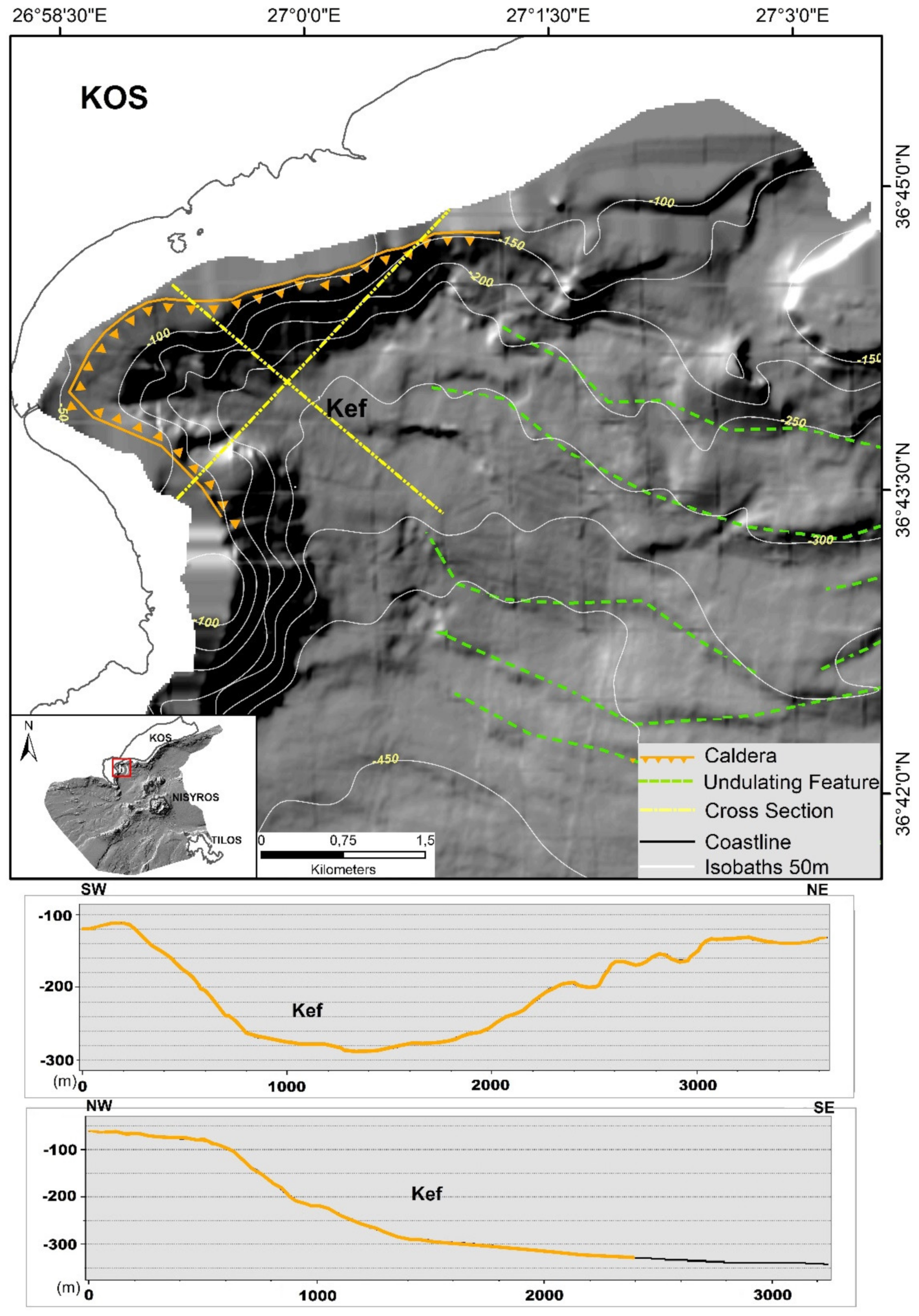
the Kefalos caldera, is observed at the south-western part of Kos Island, to the southeast of the Kefalos Peninsula and its formation occurred during the Middle Pleistocene (0.5 Ma) [43]. The offshore caldera rim is characterized by steep slopes of 20–30° and the caldera base lies at depths from 220 m to 300 m (Figure 9). Only the western part of the Kefalos caldera is preserved whereas its eastern continuation has collapsed and the result is an undulating morphology of arcuate terraces reaching 400 m to 450 m water depth, similar to La Fossa Caldera at Vulcano which is partially submerged [56,57]. The undulating feature is characterized by 10–20° of slope and resembles a radial flow southwards to the basinal area of the Western Kos Basin (see also Figure 14).
A special morphology indicating volcanic debris avalanche deposits is observed on the submarine slopes southeast and southwest of the Nisyros volcanic structure. A number of 364 hills/hummocks were counted through geoprocessing procedure throughout the avalanche field (Figure 10). They form clusters at varying depths between 196 m to 769 m and extend as far as 20 km away from the Nisyros coast. The shape of these hummocks varies from circular round to elongated and asymmetrical blocks of different orientations, having an average axial length of 350 m (the larger ones). A distinct debris avalanche deposit has been studied in detail on the southeast flank of Nisyros [16,58,59,60]. It is likely that it originated onshore and covers an area of about 90 km2. The overall volume is estimated about 1 km3 and the average thickness 40–50 m at water depths between 250 m and 410 m. The blocks display elongation parallel to the flow of the debris avalanches from the Nikia rhyolites cropping out at southeast Nisyros Island [16]. The volcanic debris avalanche comprises numerous hills rising up to 60 m above the sea bottom and longitudinal ridges, revealing a horseshoe-shaped structure.

4.4. Submarine Drainage System

The streams onshore discharge to the sea, where they continue their route on the seafloor, forming a well- organized submarine drainage network, which ends up into the three submarine basins (Figure 11).
According to the Strahler’ technique four orders of streams are developed in the submarine region. Streams of 1st, 2nd and 3rd class have been formed along the southern continental slopes of Kos Island. Along the slopes of the Kos margin a number of submarine canyons have been formed, probably by fast-flowing turbidity currents carrying terrigenous sediments. The canyons usually correspond to 1st or 2nd order streams/channels, characterized by steep walls and high incision characteristics along steep morphological slopes [61]. They are observed from their head at shallow depth down to the smoothing of the slopes at the margin of the sub-horizontal basinal areas. The canyons usually continue as higher order channels in the basinal area where they may gradually disappear by discharging their transported material in the sea bed. Thus, along the southern slopes of Kos Island, these submarine channels start from 150 m of depth to 550–640 m where the morphological slopes values become very low. The transport and deposition of sediments from the channels form fan-shaped deposits, especially at the Eastern Kos basin. Thus, the drainage network represents the continuation of the onshore one. The dominant drainage pattern at the Kondeliousa Basin is dendritic and follows the NE-SW ridges orientation of the submarine morphology. Streams up to the 4 th order extend along the northern flanks of the Kondeliousa Basin seafloor, forming channels with deposition of unconsolidated sediments in between the parallel submarine volcanic outcrops as detected in the seismic profiles [27,36] The main characteristic of the drainage system along the southern Kos margin is the absence of a major stream, oriented ENE-WSW, receiving the N-S to NNW-SSE channels. This is due to the fact that the transported material is deposited as long as it reaches the basinal areas of the Eastern and Western Kos basins. On the contrary, the minor N-S streams of the northern margin of the Kondeliousa Basin join the higher order streams of ENE-WSW orientation draining to the west, outside the studied area.

4.5. Submersible Diving and ROV Exploration

Several submarine volcanic structures have been observed at various depths down to 504 m through submersible diving and ROV exploration. Submersible dives with submersible THETIS of the HCMR (Hellenic Center for Marine Research) were operated during 2000 at the NW flank of the volcanic cone of Strongyli and at the subvertical slopes of the East Kondeliousa volcanic domes [24]. Some volcanic craters were discovered at 240 m of depth in Strongyli and at 430 m of depth in Kondeliousa (Figure 12). Small volcanic craters were also discovered on the northwest slopes of Strongyli volcanic cone by ROV in 2010 [26,36]. Several dives with submersible THETIS made observations at the northern abrupt slopes of the volcanic cone of Pergousa and Pachia volcanic dome starting from the depth of 380 m and 250 m respectively. Additionally, submarine dives made observations at the western slope of the Nisyros-Yali basin along the N-S striking fault zone where a landslide occurred probably during the seismic activity of July 1996 [55].
The ROVs Hercules and Argus during the “Nautilus” cruise in October 2010, were deployed in five locations (the Avyssos crater, the slopes of Yali, Strongyli, and Kondeliousa Islands, and a suspected debris avalanche deposit southeast of Nisyros) [26]. ROV exploration of the eastern flank of Yali revealed wavy sedimentary structures with dark sediments on the ridges and light sediments in the troughs, as well as linear fractures at various depths. Small craters were discovered on the northwest slopes of Strongyli, aligned with ENE-WSW trending fractures, without any sign of hydrothermal activity. The outcrops of the volcanic rocks on the flanks of Yali and Strongyli volcanoes are covered by heavy biogenic encrustations. Bio-encrustations were observed on the steep cliffs of the volcanic domes of Kondeliousa with large fields of feather corals bearing elasmobranch egg cases on them, as well as patches of biogenic sediments with abundant sponges (Figure 13). The ROV dive on this region confirmed the tectonic boundary between the Mesozoic limestones of Kondeliousa Island to the southwest and the recent volcanic rocks towards the northeast.

5. Synthesis and Geohazard Implications

The synthesis of the previously presented data is given in the morphotectonic map of the submarine area of the Nisyros graben between Kos and Tilos islands (Figure 14).
The Kos–Tilos tectonic graben shows ENE-WSW orientation in the eastern part which becomes NE-SW in the western part towards the Karpathos Basin with increasing depth. The recent volcanic activity spreads out along the central area of the graben around Nisyros Island. To the north on Kos Island the volcanic activity is present since late Miocene with more recent eruptions the Kefalos caldera 0.5 Ma ago and the deposition of the Kos ignimbrite 0.161 Ma ago [14,22]. On the contrary, to the south, on Tilos Island [46], there is no volcanic activity, except for the deposition of some ignimbrite pumice outcrops of the Kos ignimbrite mega-eruption [44]. The volcanic structures can be distinguished in: (1) a number of volcanic cones and calderas such as the Nisyros stratovolcano cone and caldera, the Yali, Strongyli and Pergousa cones and the Avyssos caldera. (2) several volcanic domes oriented NE-SW along a distinct zone from the East Kondeliousa, Pachia and Prophitis Ilias domes of rhyodacite composition. Another group of volcanic domes/dikes is observed at the basinal area of the Kondeliousa Basin at depths around 500 m, which are also oriented NE-SW. It is remarkable that submarine debris avalanches made of volcanic rocks are observed around the Nisyros major volcanic structure mainly towards the southwest to southeast slopes at distances up to 15 km–20 km [16,59,60].
The two margins of the graben are very different with numerous channels and canyons dissecting the abrupt slopes of the Kos southern margin ending down to 500–600 m depth in the Eastern and Western Kos basins contrary to the Tilos north-northwest margin where they are absent. Additionally, the Kos margin is very abrupt and is developed very close to the coast line contrary to the Tilos margin which extends much further to the west, forming a sub-horizontal plateau at about 300 m depth. Another special structure is the Kondeliousa horst which towards the west is developed upon the Alpine Mesozoic limestones and forms a sub-horizontal plateau at about 400 m depth. This plateau is interrupted by a fault immediately east of the Kondeliousa islet and at its continuation to the NE it is substituted by the East Kondeliousa, Pachia and Prophitis Ilias volcanic domes.
The volcanic relief emerges from the average depth of the basinal areas of 600 m and reaches 700 m of height on the Nisyros post-caldera domes. Thus, an overall volcanic edifice of about 1300 m is built within the Kos-Nisyros-Tilos graben structure since Middle Pleistocene.
The geological hazards in the Nisyros volcanic area within the Kos-Tilos graben comprise:
(1)
Seismic hazard resulting from the activation of the faults. This hazard is different in trems of the activation of marginal main faults with a few tens of km length, such as the magnitude 6.6 1933 event on Kos, which affected also Nisyros Island [62] than in the case of intra-volcanic edifice faults of a few km length, such as the magnitude 5.6 1996–1997 events on Mandraki/Nisyros [63], which activated the N-S fault of northern Nisyros and its offshore prolongation towards Yali Island [55]. More recently, in 2017 a 6.3 event occurred at another main fault east of Kos Island between the Greek and Turkish waters with significant losses [64]. In several cases the earthquake epicenters occur offshore along active marginal faults trending ENE-WSW to E-W that border the present marine basins from the islands [27]. This tectonic trend is regional characterizing the eastern part of the Aegean volcanic arc in the back arc area of the actual Hellenic arc and trench system (see also Figure 1) resulting from a regional N-S extension [65].
(2)
Volcanic hazard occurs in the active craters of Nisyros, Yali, Strongyli, Kondeliousa and to a lesser degree in Pergousa and Pachia. The last minor eruptions have occurred on Nisyros in 1887 [17]. The recurrence period of such eruptions may be estimated from the voluminous volcanic products during the Late Pleistocene and Holocene in the area during a few thousands of years. Distinction should be made between the Plinian type explosions with deposition of pumice layers both onshore and offshore from the lava extrusions in the form of rhyodacitic domes. However, iconic mega-eruption similar to the Kos ignimbrite eruption 161 Ka ago may be expected from the volcanic activity in the submarine Avyssos caldera. This event has more than 100 thousand years cycle and represents a major volcanic threat for the broader area of the eastern Dodecanese islands and the coastal zone of Minor Asia. Submarine volcanic eruptions may also occur along the E-W dikes/domes of the Kondeliousa Basin but their impact is not expected to be important in the onshore areas.
(3)
Tsunami hazard is expected due to seismic activity of the marginal fault zones that may generate major earthquakes of magnitude 6–7 similar to the 1956 Amorgos event [66,67,68]. Additional tsunami hazard is expected due to submarine sliding, as observed at the broader zones of volcanic debris avalanches especially at the SE and SW slopes of the Nisyros volcanic center and at the undulating slopes of the disrupted Eastern Kefalos caldera. However, tsunami deposits have not been reported up to present in the surrounding coastal areas, although there are several sites with appropriate lagoon type environment, especially in Kos Island.
Since Middle Pleistocene the volcanic activity is taking place within the Kos-Nisyros-Tilos graben structure either on the islands or in the submarine surrounding area. Thus, the base of the volcanic structures occurs at an average depth of 600 m and culminates at several hundred m higher either below sea level or at several hundred m altitude. It is characteristic that on Nisyros Island the first lavas are pillow lavas and the transition to aerial explosions occurs higher in the volcano-stratigraphy of the first stratovolcano period of Nisyros [11,36]. However, this area paleogeographically belonged to the Neogene Aegeis land bridge, developed between continental Greece and Minor Asia [69]. Thus, in Kos there are continental deposits with lacustrine fossiliferous formations of Upper Miocene-Pliocene age [8,41]. The same facies occurs also in the other east Aegean islands both towards the north (e.g., Samos and Chios) and the south (e.g., Rhodes). The first post-Alpine marine outcrops overlying Aegeis land mass occur in southeast Ikaria Island deposited during Early Pliocene [70] and in Kos and Rhodes islands deposited during middle-late Pleistocene [71,72]. Thus, the subsidence observed within the Kos-Nisyros-Tilos tectonic graben is post early Pleistocene and it is accompanied also by submarine volcanism. The volcanic structures comprise submarine basal volcanic formations and onshore upper parts with subaerial explosions, observed in the volcanic islands. The onshore volcanic outcrops of middle-late Pleistocene age observed on Kos, Tilos and surrounding areas are pyroclastic-pumice-tephra products of volcanic activity occurring within the Nisyros volcanic group [15,17,44]. The mid Pleistocene eastern Kefalos volcanic event is located at the present coastal area of western Kos [43]. The Kefalos caldera was combined with its upper part onshore and the middle and lower part offshore. However, only its western part is preserved whereas its eastern part has been disrupted and forms a submarine undulating slope zone towards the Western Kos basinal area. The mixed nature of the Kefalos caldera resembles the multi-stage formation of La Fossa Caldera at Vulcano Island, Italy [54,56,57].
Strongyli volcanic cone is differentiated from all the other volcanic islands because of its geometry and the absence of any pyroclastic/pumice deposit on it. Additionally, its location at the southwestern margin of the Avyssos caldera implies a probable post caldera development, as the contact between the Strongyli base and the SW margin of the Avyssos caldera indicates. Nevertheless, there are human constructions at the small, planar area of its crater with cultivation terraces.
The 1.8 km overall subsidence of the Alpine basement in Nisyros Island [29,30] is compensated by the building of the volcanic relief in at least two stages (stratovolcano and post caldera domes). This is observed also in the ENE-WSW oriented zone of volcanic domes observed from the East Kondeliousa submarine domes to the Pachia and Prophitis Ilias domes of Nisyros Island. This volcanic zone is located at the middle of the Kos–Nisyros–Tilos graben structure and follows its geometry and geodynamic characteristics with extension in the NNW-SSE direction.
The main marginal faults with important seismic events are also oriented in ENE-WSW direction and this is also observed in the overall morphological structure of the area. Additionally, the same direction is noticed along the domes of the Kondeliousa Basin. NNW-SSE extension is detected in the GPS rates of the area [65] as well as in the fault plane solutions of large earthquakes [73].
The extended submarine areas of debris avalanches to the SE and SW of Nisyros Island resemble the hummocky terrains formed by the debris avalanches with alignment of the hummocks in the collapse affecting the E flank of Stromboli [74,75]. They represent a potential tsunami hazard triggered by the slope instabilities of the volcanic islands as this is known from several cases worldwide [76,77]. Slope instabilities are observed also along the southern margin of Kos Island and especially at the eastern Kefalos collapsing caldera with undulating zones, where various types of landslides may occur during seismic activity [78,79].
In conclusion, the volcanic hazard of the area is of major concern, although since 1887 there is no activity, contrary to the Santorini intense activity throughout the 19th and first half of 20th century [80,81,82]. An unrest period was observed during 1996–1997 with earthquakes and minor changes of the thermal waters and gas emissions, followed by GPS measurements that indicated uplift and radial opening of Nisyros Island [83]. However, since 1998 this activity ceased and there are no more signs of unrest. In any case, the volcanic hazard is known in the area since pre-historic times and the Nisyros genesis is attributed according to the Greek mythology to the Giant Polyvotis, who has been buried below Nisyros from Poseidon. The name Polyvotis means someone creating a lot of noise, which probably corresponds to the sounds produced during the volcanic eruptions and/or major earthquakes.

Author Contributions

P.N. was involved in the field data collection, participated in results interpretation and paper writing; P.K. was involved in order to implement geospatial techniques and to interpret spatial derived data; S.K. participated by conducting data interpretation and assisted in the paper writing; D.P. and N.K. contributed to the paper editing. All authors have read and agreed to the published version of the manuscript.

Funding

This research received no external funding.

Data Availability Statement

Data available upon request.

Acknowledgments

Seafloor mapping was a part of the GEOWARN project (Contract no: IST-1999-12310). The European Commission is acknowledged for their financial contribution to the project. ROV exploration was supported by Institute for Exploration (IFE-USA) and the collaborative project “New Frontiers in the Ocean Exploration”. The authors would like to thank the officers and the crew of the R/V AEGAEO and E/V NAUTILUS for their effective contribution to the field work. This work has been [fully/partially] supported by NEANIAS, funded by the European Union’s Horizon 2020 research and innovation programme, under grant agreement No 863448. Maps and diagrams throughout this work were created using ArcGIS® software by Esri. ArcGIS® and ArcMap™ are the intellectual property of Esri and are used herein under license. Copyright © Esri. All rights reserved. We also thank Daniele Casalbore and two other anonymous reviewers whose comments improved the manuscript.

Conflicts of Interest

The authors declare no conflict of interest.

References

  1. McKenzie, D.P. Active tectonics of the Mediterranean Region. Geophys. J. Int. 1972, 30, 109–185. [Google Scholar] [CrossRef] [Green Version]
  2. Le Pichon, X.; Angelier, J. The Hellenic arc and trench system: A key to the evolution of the Eastern Mediterranean. Tectonophysics 1979, 60, 1–42. [Google Scholar] [CrossRef]
  3. Papanikolaou, D. Geotectonic evolution of the Aegean. Bull. Geol. Soc. Greece 1993, 28, 33–48. [Google Scholar]
  4. Jackson, J. Active tectonics of the Aegean region. Annu. Rev. Earth Planet. Sci. 1994, 22, 239–271. [Google Scholar] [CrossRef]
  5. Pe-Piper, G.; Piper, D.J.W. The South. Aegean active volcanic arc: Relationships between magmatism and tectonics. In The South Aegean Active Volcanic Arc; Fytikas, M., Vougioukalakis, G.E., Eds.; Elsevier: Amsterdam, The Netherlands, 2005; pp. 113–133. [Google Scholar]
  6. Keller, J.; Rehren, T.; Stadlbauer, F. Explosive volcanism in the Hellenic Arc: A summary and review. In Thera and the Aegean World III; Hardy, D.A., Keller, J., Galanopoulos, V.P., Flemming, M.C., Druitt, T.H., Eds.; Thera Foundation London: London, UK, 1990; Volume 2, pp. 13–26. [Google Scholar]
  7. Martelli, A. Il gruppo eruttivo di Nisyros nel mare. Egeo. Mem. Soc. Geol. Ital. Sci. 1917, 20, 93. [Google Scholar]
  8. Desio, A. Le isole italiane dell’Egeo. Mem. Carta Geol. D’Ital. 1931, 24, 534. [Google Scholar]
  9. Davis, E.N. Zur geolofie und Petrologie der Inseln Nisyros und Jail (Dodekanes). Prakt. Acad. Athens 1967, 42, 235–252. [Google Scholar]
  10. Di Paola, U. Volcanology and petrology of Nisyros Island (Dodecannese, Greece). Bull. Volcanol. 1974, 38, 944–987. [Google Scholar] [CrossRef]
  11. Papanikolaou, D.; Lekkas, E.; Sakellariou, D. Geological structure and evolution of the Nisyros volcano. Bull. Geol. Soc. Greece 1991, 25, 405–419. [Google Scholar]
  12. Limburg, E.M.; Varekamp, J.C. Young pumice deposits on Nisyros, Greece. Bull. Volcanol. 1991, 54, 68–77. [Google Scholar] [CrossRef]
  13. Vougioukalakis, G. Volcanic stratigraphy and evolution of Nisyros island. Bull. Geol. Soc. Greece 1993, 28, 239–258. [Google Scholar]
  14. Allen, S.R. Reconstruction of a major caldera-forming eruption from pyroclastic deposit characteristics: Kos Plateau Tuff, eastern Aegean Sea. J. Volcanol. Geotherm. Res. 2001, 105, 141–162. [Google Scholar] [CrossRef]
  15. Volentik, A.; Vanderkluysen, L.; Principe, C. Stratigraphy of the caldera walls of Nisyros volcano, Greece. Eclogae Geol. Helv. 2002, 95, 223–235. [Google Scholar]
  16. Tibaldi, A.; Pasquarè, F.A.; Papanikolaou, D.; Nomikou, P. Discovery of a huge sector collapse at the Nisyros volcano, Greece, by on-land and offshore geological-structural data. J. Volcanol. Geotherm. Res. 2008, 117, 485–499. [Google Scholar] [CrossRef]
  17. Dietrich, V.J.; Lagios, E. (Eds.) Nisyros Volcano, Active Volcanoes of the World; Springer: Berlin, Germany, 2018; pp. 13–55. ISBN 978-3-319-55458-7. [Google Scholar]
  18. Piper, D.J.W.; Pe-Piper, G.; Anastasakis, G.; Reith, W. The volcanic history of Pyrgousa—Volcanism before the eruption of the Kos Plateau Tuff. Bull. Volcanol. 2019, 81, 32. [Google Scholar] [CrossRef]
  19. Vinci, A. Distribution and chemical composition of tephra layers from Eastern Mediterranean abyssal sediments. Mar. Geol. 1985, 64, 143–155. [Google Scholar] [CrossRef]
  20. Koutrouli, A.; Anastasakis, G.; Kontakiotis, G.; Balengee, S.; Kuehn, S.; Pe-Piper, G.; Piper, D.J.W. The early to mid-Holocene marine tephrostratigraphic record in the Nisyros-Yali-Kos volcanic center, SE Aegean Sea. J. Volcanol. Geotherm. Res. 2018, 366, 96–111. [Google Scholar] [CrossRef]
  21. Longchamp, C.; Bonadonna, C.; Bachmann, O.; Skopelitis, A. Characterization of tephra deposits with limited exposure: The example of the two largest explosive eruptions at Nisyros volcano (Greece). Bull. Volcanol. 2011, 73, 1337. [Google Scholar] [CrossRef] [Green Version]
  22. Hardiman, J. Deep sea tephra from Nisyros Island, Eastern Aegean Aea, Greece. Geol. Soc. Lond. Spec. Publ. 1999, 161, 69–88. [Google Scholar] [CrossRef]
  23. Nomikou, P.; Papanikolaou, D. Detection of submarine volcanoes in the Kos-Nisyros area. Newsl. Eur. Cent. Prev. Forecast. Earthq. 1999, 3, 12–14. [Google Scholar]
  24. Papanikolaou, D.; Nomikou, P. Tectonic structure and volcanic centres at the eastern edge of the Aegean volcanic arc around Nisyros Island. Bull. Geol. Soc. Greece 2001, 34, 289–296. [Google Scholar] [CrossRef]
  25. Nomikou, P.; Papanikolaou, D. The morphotectonic structure of Kos-Nisyros-Tilos volcanic area based on onshore and offshore data. In Proceedings of the XIX Congress of the Carpathian-Balkan Geological Association, Thessaloniki, Greece, 23–26 September 2010; Volume 99, pp. 557–564. [Google Scholar]
  26. Nomikou, P.; Bell, K.L.C.; Papanikolaou, D.; Livanos, I.; Fero Martin, J. Exploring the Avyssos-Yali-Strogyli submarine volcanic complex at the eastern edge of the Aegean Volcanic Arc. Z. Geomorphol. 2013, 57, 125–137. [Google Scholar] [CrossRef]
  27. Nomikou, P.; Papanikolaou, D.; Alexandri, M.; Sakellariou, D.; Rousakis, G. Submarine volcanoes along the Aegean volcanic arc. Tectonophysics 2013, 597, 123. [Google Scholar] [CrossRef]
  28. Nomikou, P.; Papanikolaou, D. A comparative morphological study of the Kos-Nisyros-Tilos volcanosedimentary ba-sins. Bull. Geol. Soc. Greece 2010, 43, 464–474. [Google Scholar] [CrossRef] [Green Version]
  29. Geotermica Italiana. Nisyros 1 Geothermal Well; PPC-EEC Report; Geotermica Italiana: San Giuliano Terme, Italy, 1983; p. 160. [Google Scholar]
  30. Geotermica Italiana. Nisyros 2 Geothermal Well; PPC-EEC Report; Geotermica Italiana: San Giuliano Terme, Italy, 1984; p. 44. [Google Scholar]
  31. Passaro, S.; de Alteriss, G.; Sacchi, M. Bathymetry of Ischia Island and its offshore (Italy), scale 1, 50.000. J. Maps 2016, 12, 152–159. [Google Scholar] [CrossRef]
  32. Casalbore, D.; Bosman, A.; Romagnoli, C.; Chiocci, F.L. Morphology of Salina offshore (Southern Tyrrhenian Sea). J. Maps 2015, 12, 725–730. [Google Scholar] [CrossRef]
  33. Quartau, R.; Ricardo, S.; Madeira, J.; Santos, R.; Rodrigues, A.; Roque, C.; Carrara, G.; da Silveira, A. Gravitational, erosional and depositional processes on volcanic ocean islands: Insights from the submarine morphology of Madeira Archipelago. Earth Planet. Sci. Lett. 2018, 482, 288–299. [Google Scholar] [CrossRef] [Green Version]
  34. Santos, R.; Quartau, R.; da Silveira, A.; Ramalho, R.; Rodrigues, A. Gravitational, erosional, sedimentary and volcanic processes on the submarine environment of Selvagens Islands (Madeira Archipelago, Portugal). Mar. Geol. 2019, 415, 105945. [Google Scholar] [CrossRef]
  35. Casalbore, D. Volcanic Islands and Seamounts. In Submarine Geomorphology; Micallef, A., Krastel, S., Savini, A., Eds.; Springer Geology; Springer: Cham, Switzerland, 2018. [Google Scholar] [CrossRef]
  36. Nomikou, P.; Papanikolaou, D.; Dietrich, V. Geodynamics and Volcanism in the Kos-Yali-Nisyros Volcanic Field; Dietrich, V., Lagios, E., Eds.; Springer: Berlin, Germany, 2018; pp. 13–56. [Google Scholar]
  37. Royden, L.H.; Papanikolaou, D. Slab segmentation and late Cenozoic disruption of the Hellenic arc. Geochem. Geophys. Geosyst. 2011, 12, Q03010. [Google Scholar] [CrossRef]
  38. Papanikolaou, D.; Lykousis, V.; Chronis, G.; Pavlakis, P. A comparative study of neotectonic basins across the Hellenic arc: The Messiniakos, Argolikos, Saronikos and southern Evoikos gulfs. Basin Res. 1988, 1, 167–176. [Google Scholar] [CrossRef]
  39. Pavlakis, P.; Lykoussis, V.; Papanikolaou, D.; Chronis, G. Discovery of a new submarine volcano in the western Saronic Gulf: The Paphsanias Volcano. Bull. Geol. Soc. Greece 1990, 24, 59–70. [Google Scholar]
  40. Tibaldi, A.; Pasquarè, F.A.; Papanikolaou, D.; Nomikou, P. Tectonics of Nisyros Island, Greece, by field and offshore data, and analogue modeling. J. Struct. Geol. 2008, 30, 1489–1506. [Google Scholar] [CrossRef]
  41. Papanikolaou, D.; Nomikou, P. The Palaeozoic of Kos: “A low grade metamorphic unit of the basement of the External Hellenides Terrane”. Spec. Publ. Geol. Soc. Greece 1998, 3, 155–166. [Google Scholar]
  42. Altherr, R.; Keller, J.; Kott, K. Der jungtertiare Monzonit von Kos und sein Kontakthof (A. gais, Griechenland). Bull. Soc. Géol. Fr. 1976, 7, 403–412. [Google Scholar] [CrossRef]
  43. Dalabakis, P.; Vougioukalakis, G. The Kefalos Tuff Ring (W. Kos): Depositional mechanisms, vent position, and model of the evolution of the eruptive activity. Bull. Geol. Soc. Greece 1993, 28, 259–273. [Google Scholar]
  44. Dalabakis, P. Une des plus puissantes eruptions phreatomagmatiques dans la Mediterranee orientale: L’Ignimbrite de Kos (Greece). CR Acad. Sci. Paris 1987, 303, 505–508. [Google Scholar]
  45. Sterba, J.H.; Steinhauser, G.; Bichler, M. On the geochemistry of the Kyra eruption sequence of Nisyros volcano on Nisyros and Tilos, Greece. Appl. Radiat. Isot. 2011, 69, 1605–1612. [Google Scholar] [CrossRef]
  46. Volentik, A.; Vanderkluysen, L.; Principe, C.; Hunziker, J.C. Stratigraphy of Nisyros volcano (Greece). In The Geology, Geochemistry and Evolution of Nisyros Volcano (Greece): Implications for the Volcanic Hazards; Hunziker, J.C., Marini, L., Eds.; Université de Lausanne: Lausanne, Switzerland, 2005; Volume 44, pp. 26–67. [Google Scholar]
  47. Stiros, S.; McGuire, W.J.; Griffiths, D.R.; Hancock, P.L.; Stewart, I.S. Fault pattern of Nisyros Island Volcano (Aegean Sea, Greece); structural, coastal and archaeological evidence. In The Archaeology of Geological Catastrophes; Geological Society Special Publications: London, UK, 2000; Volume 171, pp. 385–397. [Google Scholar]
  48. Nomikou, P.; Papanikolaou, D.; Alexandri, S.; Ballas, D. New insights on the Kos–Nisyros volcanic field from the morphotectonic analysis of the swath bathymetric map. Rapp. Comm. Int. Mer. Medit. 2004, 37, 60. [Google Scholar]
  49. Nomikou, P.; Bell, K.L.C.; Vougioukalakis, G.; Livanos, I.; Fero, M.J. Exploring the Nisyros Volcanic Field. In New Frontiers in Ocean Exploration: The E/V Nautilus 2010 Field Season; Bell, K.L.C., Fuller, S.A., Eds.; The Oceanography Society: Rockville, MD, USA, 2011; Volume 24, p. 27. [Google Scholar]
  50. Wintersteller, P.; Foskolos, N.; Ferreira, C.; Karantzalos, K.; Lampridou, D.; Baika, K.; Anbar, J.; Quintanta, J.; Kokorotsikos, S.; Pisa, C.; et al. The NEANIAS project. Bathymetric mapping and processing go cloud. J. Appl. Hydrogr. 2021, 118, 30–36. [Google Scholar] [CrossRef]
  51. Krassakis, P.; Kazana, S.; Chen, F.; Koukouzas, N.; Parcharidis, I.; Lekkas, E. Detecting subsidence spatial risk distribution of ground deformation induced by urban hidden streams. Geocarto Int. 2019, 36, 622–639. [Google Scholar] [CrossRef]
  52. Strahler, A. Quantitative Analysis of Watershed Geomorphology. Trans. Am. Geophys. Union 1957, 38, 913–920. [Google Scholar] [CrossRef] [Green Version]
  53. Bartlett, D.; Celliers, L. (Eds.) Geoinformatics for Marine and Coastal Management; CRC Press: Boca Raton, FL, USA, 2017. [Google Scholar] [CrossRef]
  54. Nyberg, B.; Nixon, C.W.; Sanderson, D.J. Network, G.T: A GIS tool for geometric and topological analysis of two-dimensional fracture networks. Geosphere 2018, 14. [Google Scholar] [CrossRef] [Green Version]
  55. Nomikou, P.; Papanikolaou, D. Extension of active fault zones on Nisyros volcano across the Yali-Nisyros Channel based on onshore and offshore data. Mar. Geophys. Res. 2011, 32, 181–192. [Google Scholar] [CrossRef]
  56. Romagnoli, C.; Casalbore, D.; Chiocci, F.L. La Fossa Caldera breaching and submarine erosion (Vulcano island, Italy). Mar. Geol. 2012, 303, 87–98. [Google Scholar] [CrossRef]
  57. Casalbore, D.; Romagnoli, C.; Bosman, A.; De Astis, G.; Lucchi, F.; Tranne, C.A.; Chiocci, F.L. Multi-stage formation of La Fossa Caldera (Vulcano Island, Italy) from an integrated subaerial and submarine analysis. Mar. Geophys. Res. 2019, 40, 479–492. [Google Scholar] [CrossRef]
  58. Nomikou, P.; Tibaldi, A.; Mariotto, F.P.; Papanikolaou, D. Submarine Morphological analysis based on multibeam data of a huge collapse at the SE flank of Nisyros volcano, Rend. Soc. Geol. 2009, 7, 177–179. [Google Scholar]
  59. Livanos, I.; Nomikou, P.; Papanikolaou, D.; Rousakis, G. The volcanic debris avalanche on the SE submarine slope of Nisyros volcano, Greece: Geophysical exploration and implications for subaerial eruption history. Geo Mar. Lett. 2013, 33, 419. [Google Scholar] [CrossRef]
  60. Anagnostopoulos, V.K.; Anastasakis, G. Volcanogenic mass flow deposits and seafloor diapirism following the largest insular Quaternary eruption of the eastern Mediterranean at Nisyros island, Aegean volcanic arc. Mar. Geol. 2020, 425. [Google Scholar] [CrossRef]
  61. Amblas, D.; Ceramicola, S.; Gerber, T.P.; Canals, M.; Chiocci, F.L.; Dowdeswell, J.A.; Harris, P.T.; Huvenne, V.A.I.; Lai, S.Y.J.; Lastras, G.; et al. A Submarine Canyons and Gullies. In Springer Geology; Springer: Berlin/Heidelberg, Germany, 2018; pp. 251–272. [Google Scholar] [CrossRef]
  62. Papazachos, B.; Papazachou, C. The Earthquakes of Greece; Ziti Publications: Thessaloniki, Greece, 2003; 286p. [Google Scholar]
  63. Sachpazi, M.; Kontoes, C.; Voulgaris, N.; Laigle, M.; Vougioukalakis, G.; Sikioti, O.; Stavrakakis, G.; Baskoutas, J.; Kalogeras, J.; Lepine, J.C. Seismological and SAR signature of unrest at Nisyros Caldera, Greece. J. Volcanol. Geotherm. Res. 2002, 116, 19–33. [Google Scholar] [CrossRef]
  64. Ocakoğlu, N.; Nomikou, P.; İşcan, Y.; Loreto, M.F.; Lampridou, D. Evidence of extensional and strike-slip deformation in the offshore Gökova-Kos area affected by the July 2017 Mw6.6 Bodrum-Kos earthquake, eastern Aegean Sea. 2018. Geo Mar. Lett. 2018, 38, 211. [Google Scholar] [CrossRef]
  65. Reilinger, R.; McClusky, S.; Paradissis, D.; Ergintav, S.; Vernant, P. Geodetic constraints on the tectonic evolution of the Aegean region and strain accumulation along the Hellenic subduction zone. Tectonophysics 2010, 488, 22–30. [Google Scholar] [CrossRef]
  66. Okal, E.; Synolakis, C.E.; Uslu, B.; Kalligeris, N.; Voukouvalas, E. The 1956 earthquake and tsunami in Amorgos, Greece. Geophys. J. Int. 2009, 178, 1533–1554. [Google Scholar] [CrossRef] [Green Version]
  67. Brüstle, A.; Friederich, W.; Meier, T.; Gross, C. Focal mechanism and depth of the 1956 Amorgos twin earthquakes from waveform matching of analogue seismograms. Solid Earth 2014, 5, 1027–1044. [Google Scholar] [CrossRef] [Green Version]
  68. Nomikou, P.; Hübscher, C.; Papanikolaou, D.; Farangitakis, P.G.; Ruhnau, M.; Lampridou, D. Expanding extension, subsidence and lateral segmentation within the Santorini–Amorgos basins during Quaternary: Implications for the 1956 Amorgos events, central-south Aegean Sea, Greece. Tectonophysics 2018, 722, 138. [Google Scholar] [CrossRef]
  69. Philippson, A. Beitrage zur Kenntnis der griechischen Inselwelt. Petermanns Geogr. Mitt. Erganz. 1901, 184, 1–172. [Google Scholar]
  70. Ktenas, C. Decouverte du Pliocene inferieur marin dans l’ile de Nikaria (Mer Egee). Comptes Rendus L’Acad. Sci. Paris 1927, 184, 756–758. [Google Scholar]
  71. Mutti, E.; Orombelli, G.; Pozzi, R. Geological Studies of the Dodecanese Islands (Aegean Sea). Geological map of the Island of Rhodes and Explanatory Notes. Ann. Geol. Des. Pays Helléniques 1970, 22, 77–226. [Google Scholar]
  72. Pirazzoli, P.; Montaggioni, L.F.; Saliege, J.F.; Segonzac, G.; Thommeret, Y.; Vergnaud-Grazzini, C. Crustal block movements from Holocene shorelines: Rhodes Island (Greece). Tectonophysics 1989, 170, 89–114. [Google Scholar] [CrossRef]
  73. Kiratzi, A.; Louvari, E. Focal mechanisms of shallow earthquakes in the Aegean Sea and the surrounding lands determined by waveform modeling: A new database. J. Geodyn. 2003, 36, 251–274. [Google Scholar] [CrossRef]
  74. Romagnoli, C.; Casalbore, D.; Chiocci, F.L.; Bosman, A. Offshore evidence of large-scale lateral collapses on the eastern flank of Stromboli, Italy, due to structurally-controlled, bilateral flank instability. Mar. Geol. 2009, 262, 1–13. [Google Scholar] [CrossRef]
  75. Romagnoli, C.; Kokelaar, P.; Casalbore, D.; Chiocci, F.L. Lateral collapses and active sedimentary processes on the northwestern flank of Stromboli volcano Italy. Mar. Geol. 2009, 265, 101–119. [Google Scholar] [CrossRef]
  76. McGuire, W. Lateral collapse and tsunamigenic potential of marine volcan oes. Geol. Soc. Lond. Sp. Publ. 2006, 269, 121–140. [Google Scholar] [CrossRef]
  77. Urgeles, R.; Camerlenghi, A. Submarine landslides of the Mediterranean Sea: Trigger mechanisms, dynamics and frequency-magnitude distribution. J. Geophys. Res. 2013, 118, 2600–2618. [Google Scholar] [CrossRef] [Green Version]
  78. Masson, D.G.; Harbitz, C.B.; Wynn, R.B.; Pedersen, G.; Løvholt, F. Submarine landslides: Processes, triggers and hazard prediction. Philos. Trans. R. Soc. 2006, 364, 2009–2039. [Google Scholar] [CrossRef]
  79. Watt, S.F.L.; Talling, P.J.; Hunt, J.E. New insights into the emplacement dynamics of volcanic-island landslides. Oceanography 2014, 27, 46–57. [Google Scholar] [CrossRef] [Green Version]
  80. Pyle, D.M.; Elliott, J.R. Quantitative morphology, recent evolution, and future activity of the Kameni Islands volcano, Santorini, Greece. Geosphere 2006, 2, 253–268. [Google Scholar] [CrossRef]
  81. Nomikou, P.; Parks, M.Μ.; Papanikolaou, D.; Pyle, D.Μ.; Mather, T.A.; Carey, S.; Watts, A.Β.; Paulatto, M.; Kalnins, M.; Livanos, I.; et al. The emergence and growth of a submarine volcano: The Kameni islands, Santorini (Greece). GeoResJ 2014, 1, 8. [Google Scholar] [CrossRef] [Green Version]
  82. Watts, A.B.; Nomikou, P.; Moore, J.D.P.; Parks, M.M.; Alexandri, M. Historical bathymetric charts and the evolution of Santorini submarine volcano, Greece. Geochem. Geophys. Geosyst. 2015, 16, 847. [Google Scholar] [CrossRef] [Green Version]
  83. Lagios, E.; Sakkas, V.; Parcharidis, I.; Dietrich, V. Ground Deformation of Nisyros Volcano (Greece) for the period 1995–2002: Results from DInSAR and DGPS observations. Bull. Volcanol. 2005, 68, 201–214. [Google Scholar] [CrossRef]
Figure 1. The four volcanic groups of the Aegean volcanic arc (in red) and the studied area (in green frame). Kos and Tilos islands border the neotectonic graben of the Nisyros volcanic field (modified from 27). Insert map: Simplified map of the present day geodynamic structure of the Hellenic Arc, showing the modern Aegean volcanic arc developed behind the Hellenic trench, the Peloponnese-Crete island arc and the Cretan Back-arc basin (modified from 25).
Geosciences 11 00231 g001
Figure 2. Workflow of the data preparation for hydrologic and surface analysis using initial processed bathymetric data.
Geosciences 11 00231 g002
Figure 3. Synthetic topographic and tectonic map of Kos-Nisyros volcanic field based on onshore and offshore data [15,43,49]. In the upper left part of the map a rose diagram is depicting the directions and the frequency values of the faults in the study area. Av: Avyssos submarine caldera.
Geosciences 11 00231 g003
Figure 4. Morphological slope map in degrees of Kos-Nisyros-Tilos volcanic field based on onshore and offshore data. The sub-horizontal areas are well illustrated. The map has been categorized in four classes with slope values ranging from 0° to areas greater or equal than ≥20°.
Geosciences 11 00231 g004
Figure 5. Location of the three main submarine basins of the study area (a) Kondeliousa Basin (KB), (b) Western Kos Basin (WKB) and (c) Eastern Kos Basin (EKB) according to swath bathymetric data. Depth profiles of each basin are also illustrated according to their selected margins.
Geosciences 11 00231 g005
Figure 6. The Nisyros volcano consists of the older stratovolcano structure with the distinctive central caldera (in red) and the younger Prophitis Ilias (Rh) postcaldera rhyodacitic domes (in orange). The two topographic profiles depict the onshore/offshore Nisyros volcanic relief.
Geosciences 11 00231 g006
Figure 7. (a) The volcanic relief (in red) of Yali and Strongyli islets is shown in the topographic profile of Yali-Strongyli where the volcanic structures of the Western Yali (Wy), Eastern Yali (Ey), Strongyli (St) and Avyssos caldera (Av) are depicted and (b) the volcanic relief (in red) of Pergousa (Pe) islet, Pachia (Pa) islet and East Kondeliousa (EKo) submarine volcanic dome (EKo) and the relief of Kondeliousa islet (Ko) are also depicted in topographic profiles.
Geosciences 11 00231 g007
Figure 8. The slightly asymmetric circular Avyssos (Av) caldera at the southern part of the Eastern Kos Basin is characterized by a nearly horizontal planar floor according to the topographic profiles. The volcanic relief of Strongyli (St) and Avyssos (Av) submarine caldera are depicted in topographic profiles. Ya: Yali islet.
Geosciences 11 00231 g008
Figure 9. Half of the Kefalos caldera (Kef) located at the northwestern part of the Western Kos Basin (Figure 3) is expanded offshore and characterized by steep slopes. Undulating features are also illustrated with green dashed lines showing the direction of a radial flow. The volcanic relief of Kefalos (Kef) submarine caldera is depicted in topographic profiles.
Geosciences 11 00231 g009
Figure 10. Hillshade map of the SE Nisyros submarine area, with 10 m isobaths, depicting a part of the volcanic debris avalanche field. The larger hills/hummocks are shown as closed isobaths in the map (yellow arrows). Slope profiles (in degrees) along the debris avalanches interpret their shape to horizontal distance.
Geosciences 11 00231 g010
Figure 11. The submarine drainage network along the southern continental slopes of Kos Island, ending into the three submarine basins of Kondeliousa, Western Kos and Eastern Kos. The submarine drainage has been categorized according to Strahler technique. Canyons (c) are also distinguished usually developed in 1st or 2nd order streams.
Geosciences 11 00231 g011
Figure 12. (a) Part of the volcanic crater with 8–10 m diameter and height of 4 m, at the western slope of Strongyli volcanic dome (240 m depth) and (b) the edge of the volcanic crater with diameter of 4.5 m and height of 2 m at the eastern part of Kondeliousa (430 m depth).
Geosciences 11 00231 g012
Figure 13. (a) Layered biogenic concreted rocks with their surface spotted with sponges at 204 m depth at the eastern flank of Yali volcano and (b) view showing the steep vertical northern flank of the volcanic dome, NE of Kondeliousa at 230 m depth.
Geosciences 11 00231 g013
Figure 14. Integrated offshore morphotectonic map of Kos-Nisyros volcanic field. The shaded relief map comprises several volcanic and geomorphological features. The submarine volcanic relief is shown in red polygons whereas the onshore volcanic outcrops are delineated by the coastline in black. The volcanic edifice comprises also the two submarine calderas and the Nisyros volcanic debris avalanches. On Kos and Tilos islands the volcanic formations are also displayed showing the connection with offshore volcanic history.
Geosciences 11 00231 g014
Table 1. Geometric characteristics of volcanic structures of the study area estimated using 3d geoprocessing tools.
Volcanic Centers/DomesVolume Cubic Kilometer [km3]3D Surface Area [km2]2D Surface Area [km2]Base Elevation/Depth (m)Peak Elevation/Depth (m)Total Volcanic Relief m (Absolute Value)
Nisyros (including Rhyodacites Prophitis Ilias)24.2681.1377.49−242+698940
Pergousa4.5415.8015.2−490+77567
Yali14.6838.337.05−501+175676
Strongyli3.5110.729.77−675+128803
Pachia2.4010.9210.52−327+127454
East Kondeliousa1.367.917.31−451−91360
Total volcanic relief for each geometry55.42179.58170.94−675+6981373
Publisher’s Note: MDPI stays neutral with regard to jurisdictional claims in published maps and institutional affiliations.

