
Archaeoseismic Evidence of Surface Faulting in 1703 Norcia Earthquake (Central Italian Apennines, Mw 6.9)


1
Dipartimento della Protezione Civile, Via Vitorchiano 4, 00189 Rome, Italy
2
CNR-IGAG Institute of Environmental Geology and Geoengineering, Area della Ricerca di Roma 1-Strada Provinciale 35d, Montelibretti, 9-00010 Rome, Italy
*
Author to whom correspondence should be addressed.
Geosciences 2022, 12(1), 14; https://doi.org/10.3390/geosciences12010014
Submission received: 27 October 2021
/
Revised: 20 December 2021
/
Accepted: 23 December 2021
/
Published: 28 December 2021
(This article belongs to the Section Natural Hazards)
Abstract
:We present the first evidence of surface rupture along the causative fault of the 14 January 1703 earthquake (Mw 6.9, Italian central Apennines). This event was sourced by the ~30 km-long, Norcia fault system, responsible for another catastrophic event in Roman times, besides several destructive earthquakes in the last millennium. A dozen paleoseismological excavations have already investigated the surface ruptures occurred during the Holocene along the Cascia-Mt Alvagnano segments, as well as along secondary splays close to the Medieval Norcia Walls. Remarkably, the master fault bounding the Norcia-Campi basins have never be proved to rupture at the surface. An antique limekiln that was improvidently set across the main fault scarp provides the amazing evidence of an abrupt offset in the 1703 earthquake, which likely occurred during a liming process of carbonate stones. Obviously, the limekiln became useless, and was progressively buried by slope debris. The amount of the offset and the kinematics indicators surveyed in the site allow the strengthening of our knowledge on the seismogenic potential of the Norcia fault system, on its geomorphic rule, and on its impact on the human activities.
1. Introduction
Since the first intuitions of some archeologists during early excavations between the 19th–20th century [1,2,3,4], the contribution of archaeoseismology in defining the occurrence, age and strength of ancient earthquakes has become largely diffused worldwide [5,6].
More than the shaking effects of the earthquakes on the ancient buildings–usually resulting in abrupt, simultaneous collapse of roofs, walls, pillar and columns that often buried furnishings, valuables and, exceptionally, living beings—the most reliable and useful archaeoseismic evidence in earthquake geology is the surface faulting of a man-made structure [7,8,9,10,11,12,13,14,15,16]. However, while the destruction of one or more buildings could be a result of different causes but earthquakes (e.g., wars, floods, fire and aging), seismic shaking effects alone are poorly indicative in defining both the earthquake epicenter and its energy. Conversely, surface faulting unambiguously points to the seismogenic structure at depth, and thus to the epicentral area and earthquake magnitude (e.g., through fault length/displacement vs. magnitude relationships) [17,18,19,20].
This paper deals with a very small archaeologic relic, a limekiln (calcara or calchera in Italian) that worked up to the beginning of the 18th century in the Norcia basin (central Italian Apennines; orange star in Figure 1). This limekiln was set inside the tectonic scarp formed by the Norcia master fault, a primary seismogenic structure responsible for several historical destructive earthquakes [21].
The limekiln has been literally cut in half by the fault movement, allowing us to collect reliable data concerning the age, the magnitude and the kinematics of faulting, and to show, for the first time, that the Norcia master fault is an active capable fault (sensu [22]), as already documented for other segments of the same fault system, both in the Norcia [23] and in the Cascia [24] basins.
![Geosciences 12 00014 g001]()
Figure 1.
Shaded relief map of the region traversed by the Norcia fault system (blue lines, NFS. CPF, Campi-Preci faults; NF, Norcia fault; MAF, Mount Alvagnano faults; CF, Cascia faults) and by the Mount Vettore (black lines, MVFS). CFS, southern tip of the Colfiorito fault system. Yellow circles, epicenters of Mw ≥ 5.5 (modified from [23]). MVFS was responsible for the three mainshocks of the 2016 seismic sequence, labelled 2016 1−3. Orange star indicates the limekiln location.

2. Seismotectonic Framework
2.1. Active Tectonics
The Quaternary evolution of the Norcia region has been the subject of several studies [23,24,25,26,27,28] that permitted to assess that the seismogenic structures responsible for most of the seismicity of this area belong to the branched Norcia Fault System (NFS; Figure 1). The most prominent morphological feature suggesting the NFS Quaternary activity is a long, rectilinear fault-scarp carved along the eastern carbonate slopes of both the Norcia, Campi and Cascia basins, coupled with triangular facets and wine-glass valleys [29]. In the investigated area (i.e., Norcia basin), the rock fault scarp presents a smoothed-to-altered slickenside, mostly buried under a huge nail of fine, loose scree deposits, all along the eastern hillslope of the basin. The slickenside crops out only at the northern and southern tips of the fault scarp, making it possible to collect some geostructural data (Figure 2, see Supplementary Material Section S1.1).
The pseudo-fault-plane solution that accounts for all of the NFS plunge values has a strike of N152°, a dip of 59°, a striae trend of 222° and a striae plunge of 60°, with a T-axis of 240°/16°, consistent with a slightly oblique, left normal fault [23]. However, short transfer segments may strike N110°, resulting in local oblique dextral component, as in the site investigated here.
The long-term activity of the NFS has been inferred from widespread evidence of faulted Early-Middle Pleistocene slope breccias outcropping along the Mount Alvagnano, Nottoria and Norcia faults (Figure 1), and of late Early Pleistocene alluvial deposits that are displaced by secondary faults inside the Norcia basin (see [23,24] and reference therein). The Norcia basin is filled by alternating fluvial and lacustrine deposits (clays, sands and gravels with volcanoclastic levels and thick paleosols dated around 0.5 Ma; see [30]), capped by coarse deposits belonging to Late Pleistocene, coalescing alluvial fans. The largest one, in the northeastern corner of the basin, crosses perpendicularly the NFS (Patino fan, Figure 3). On the eastern outskirt of Norcia, its top surface is clearly offset by secondary fault splays, which generated an impressive graben-like feature, with fault scarps as tall as 25–30 m. Several 14C datings of paleosols and organic deposits embedded in the gravels of the Patino alluvial fan (yellow stars in Figure 3) indicate that the uppermost layers deposited during the Last Glacial Maximum, whereas the top surface of the fan was abandoned not before 12–14 ka (Table 1), when the streams feeding the fan progressively deepened their beds, down to the new base-level formed in the graben bottom.
The Norcia fault system activity has been robustly constrained by 12 paleoseismological trenches see Supplementary Material Section S1.2 opened in the past 20 years [21,23,24] that allowed to recognize and date several 1703-like events throughout the Holocene, resulting in a rough recurrence time of 1800 years, and a slip-rate > 1.2 mm/yr in the past 20 ka.
2.2. Historical Seismicity
The historical seismicity of this region dates back to Roman times (99 BCE), when an earthquake destroyed a temple in Norcia (see details in [23]). Archaeological investigations in the area have confirmed the violence of this event, providing indications of structural damage and collapses of Roman buildings precisely datable at the onset of the 1st century BCE. [32,33]. Analogously to all the Mw > 6 Apennine earthquake (Mw is Moment Magnitude), this event was strongly felt in the 120-km-far Rome metropolis, where Mars’ spears trembled in the Regia [34].
Historical sources remained silent for more than a millennium during the Middle Ages, but we do have information concerning strong earthquakes for the past seven centuries. The first one destroyed Norcia (Is 9–10 MCS; Mercalli-Cancani-Sieberg scale, [35]) and other neighboring settlements on 4 December 1328 (Mw 6.5) with 5000 victims. Another one, in 1599 (Mw 6.0), struck the villages of the Cascia basin, causing 50 victims.
Then, a catastrophic earthquake occurred on 14 January 1703 (Io, 11 MCS; Mw 6.9), when Norcia and dozens of villages around were literally razed to the ground (Is 10–11 MCS) and, again, strong effects was reported in Rome [34]. The mainshock was preceded by a damaging foreshock on 18 October 1702 (Io ~6 MCS) and by a seismic swarm continued through the entire month of November. According to a contemporary author [36], during the mainshock, “prominent chasms opened in the Norcia fields”, which implies the occurrence of extensive surface faulting. The same was reported for the hillslope of Mount Alvagnano that opened “for a length of 1.5 miles” (i.e., 2.2 km; [37,38]; or for the length of 1500 paces”; [36]) and further to the south, “for a length of 1.5 miles” [36].
In 1730, a Mw 6.0 earthquake hit again the region with severe damage in Norcia (site intensity Is 9 MCS, 200 victims in Norcia), while in 1859, a Mw 5.7 event caused new damage to many settlements with effects of Is 8–9 MCS in Norcia and the deaths of 101 people due to the collapse of several buildings. In 1979, a Mw 5.9 event induced macroseismic effects of Is 7 MCS in Norcia where faint ground breaks were observed as well along the Mount Alvagnano-Civita slopes [39,40].
At the end, the 2016 earthquakes (Mw 6.2, 6.1 and 6.6, respectively), generated by the Mt Vettore fault system (Figure 1), caused the collapse of all the churches in Norcia, besides severe damage to many buildings (Is 7–8 MCS). It is noteworthy that some splays of the faults surrounding Norcia passively accommodated the crustal deformation induced by the main Mt Vettore slip, recording up to 12 cm of surface offset (red dotted line in Figure 3), as described in [41].
3. The Faulted Limekiln
During field survey along the Norcia rock fault scarp, aside from a N137° striking, 61° dipping slickenside, we have found the amazing remains of the limekiln (Figure 3, Figure 4 and Figure 5). Its transversal section emerged below the slope wash as a consequence of emergency earth-moving works following the destructive 2016 earthquakes. We had the opportunity to survey the site before it was covered again, and to pick several samples of charcoals, charred material and organic sediment for 14C dating.
Close to the kiln, there are also the sparse ruins of a church (S. Angelo de Monte [42]) and of the ancient monastery of the Annunziata (Figure 5), founded in the first half of the 15th century by the Observants Franciscan, but soon translated and rebuilt in the early 16th century near Norcia [43], where it still stands.
The kiln was set to produce lime (also referred to as quicklime, unslaked lime, burnt lime or lump lime), burning local carbonate stones:
CO3Ca → CO2 + CaO
Lime was used since the antiquity and extensively produced and exported in Europe from the Roman period onwards [44]. Most was mixed with water (slaking) to produce hydrated lime (calcium hydroxide), which also forms the basis of plasters, mortar and concrete:
CaO + H2O → Ca(OH)2
It is likely that this kiln was designed for local use, i.e., for the restoration of the church or of the remaining structure of the first monastery. Indeed, it does not seem a permanent structure, lacking broad stone chamber with a hearth at the base. This kind of simple kiln was usually loaded with a single charge of limestone and burning had to stop for this to be removed before it could be re-loaded for the next firing. Conversely, in permanent kilns (e.g., flare-kilns and draw-kilns) a vault of stone blocks, resting on an internal ledge, was built over the hearth. The rest of the limestone was stacked above this (e.g., [44,45]). This meant that the fuel was not in direct contact with the charge of limestone or chalk and so good quality lime, unmixed with ash, was produced.
Lying as it does in an area of variable geology, the kiln had clearly been sited deliberately on the marly bedrock of the Norcia fault footwall, on land sloping to the southeast (i.e., the fault scarp), so that the mouth of the flue lays on the lower ground, a feature which has been commonly found in limekilns since Roman age [46,47].
The kiln had been set in a wineglass-shaped shaft (Figure 4, Figure 6 and Figure 7), 3-m-large and 2 m-high, dug mainly inside the calcareous marl of the Scaglia variegata formation (bottom and left side), and partly inside sandy-silty brownish colluvia, resting over the marls (upper right side) (Figure 4 and Figure 6). The calcareous marl is an adequate bedding material if subjected to high temperatures; together with the sandy-silty colluvia, they were reddened by heat to a depth of 10 and 20 cm, respectively.
3.1. Site Stratigraphy
Our observations concern the 50 m-long, NW-SE trending section where the kiln was exposed during the emergency excavations (Figure 5). As we will see, this exposure parallels the fault scarp and thus also the semi-hidden fault plane that offsets the kiln.
From the bottom, the kiln filling (Units 5 in Figure 6 and Figure 7) consists of a burning room with the fuel, made by charred bundles of firewood (level 5c). In this section, the room is 1 m wide and 0.4 m high, and is covered by a concave level of whitish ash, less than 10 cm thick (level 5b). Probably, this ash belongs to a wooden deck set over the burning room to separate it from the stone charge. Over these levels, there is the limestone charge, which is made by angular stones sized mainly between 5 and 10 cm, filling up to 0.9 m the lower part of the 2.7 m wide wineglass shaped chamber (5a). The stones charge is topped and sealed by 0.6 m (max.) of a sandy-silty fill (5), with layered pebbles and a couple of boulders, which was set here to insulate the burning of the stones. All the described levels have to do with the kiln activity, as evidenced by the heat-induced reddening of unit 5 bottom (strip b; see also the same halo in units 6–7). In the left side of the section, 4–5 m apart the kiln, Unit 4 is the remain of the repository of selected carbonate stones ready to be burned for the calcination (Figure 7).
Outside the kiln (Figure 7), Unit 7 is the Cenozoic bedrock (Scaglia variegata Formation, Eocene), made by tiny layered (5–10 cm) polychrome marls, strongly folded and truncated downhill by a subvertical fault plane paralleling the NW-SE trending outcrop. This fault is aligned with the aforementioned slickenside outcropping further SE (Figure 5). Unit 6 are brownish, layered, sandy colluvia, faulted against the fault plane and displaced also by a secondary splay by ~30 cm.
Units 1–3 (Figure 6 and Figure 7) are all slope derived deposits, each one with different granulometry and color. Unit 3 is a yellowish fine angular gravel, in sandy matrix, likely relatable to traction-carpet sheetflood debris, that mantled Units 4–5. Unit 2 is a lens of open-work fine angular gravel, rich with charcoals and modern tiles sherds (i.e., post-antique pre-industrial manufacture; F. Diosono, written communication). Unit 1 is a massive, brownish colluvial wedge, poorly sorted, resting over Unit 2 and rolled down the fault plane. Unit 1a is coarse gravel in sandy matrix, with limestone boulders which, also considering the presence of a small rill above the outcrop, could be the result of channeled debris flow.
We obtained 6 AMS datings of samples (see Supplementary Section S1.3.) collected inside and around the kiln that allowed to chronologically constrain the faulted succession (Table 1). However, it is worth noting that, due to the presence of a well-known plateau in the calibration curve, all the datings from the 17th century onwards are characterized by multimodal calendar age estimates (e.g., in 68.2% probability), even falling in very recent times. Considering the archaeological context (pottery shards, tiles and historical sources), we excluded a priori the latest probability peaks.
Two samples robustly bracket the last stocking of the kiln; one belongs to the charred bundles of firewood (Unit 5c: 1695–1725 AD), and another is a charcoal picked at the top of the limestone-charge that shares the same age of the previous sample (Unit 5a: 1695–1725 AD). The timing of the abandonment of the kiln is also indicated by the ages of charcoals picked in units 2 and 1 (1700–1720 AD and 1695–1725 AD, respectively) in the hanging-wall, both shortly predating Unit 3 that, in turn, seals the kiln in the footwall. Giving the reported 1σ delta of the 14C datings, we can assume that the kiln ended working around 1700 AD. Two other AMS datings from bulk samples provide the age of the parent material of units 5 and 1a. The first could represent the age of unit 6 (2760–2700 BP), which is the colluvium that the workers used to seal the kiln. The other is the age of the parent material from which the channeled debris flow of Unit 1a originated, which outcrops further uphill, in the footwall.
3.2. Tectonics
In paleoseismology, normal and reverse faults are investigated transversally to their trend, in trenches opened perpendicularly to strike [17]. In this work, our approach is necessarily limited to a frontal investigation of the fault that parallels the outcrop. Therefore, what we see of the kiln are just its remains, which were cut in half by the fault, and now are suspended in the footwall (Figure 7 and Figure 8). However, as the front of the outcrop and the fault have undulated trends, they intersect twice each other, offering an interesting slantwise view of the faulted deposits.
The fault plane is deeply altered and large parts have been scraped by the digger, with the exception of a triangular area in the left side. Here the surface is more preserved, showing a small portion of the striated slickenside (panel A of Figure 4). In the strip where the fault intersects the outcrop front, entering slantwise inside the hillslope (Figure 7), a fault gauge-made by a jumbled package of sands, cobbles and tiles separates the rocky footwall (Unit 7) from Units 1–4. More in detail, the fault displaces and drags Units 4–2, re-orienting clasts and tiles along the shear plane, whereas-above these units and aside the subvertical step created by the ultimate fault slip we observe the presence of a colluvial wedge (Unit 1, cw).
Most importantly, Unit 3 is the only correlative horizon between the footwall and the hanging-wall and provides an apparent offset of ~2 m (Figure 4 and Figure 7). Considering the earth-ground sloping in the footwall and the undulation of the outcrop front (i.e., the front wall is slightly advanced leftward), we calculated a vertical net offset of 1.1 m (Figure 8), which matches also the colluvial wedge height. Considering the existing empirical relationships among fault length, surficial displacement and magnitude [18,48], this offset is consistent with the coseismic rupture of a 30-km-long fault, which is the length of the NFS, and also with a Mw~7.0 earthquake, which is the magnitude of the January 1703 event.
4. Discussion
The NFS is one of the most hazardous seismogenic structures of the Apennines, responsible for some amongst the strongest earthquakes of the Mediterranean (Mw~7.0), with a rough recurrence time of 1800 years [49]. The 30 km-long system is composed by several en echelon segments that border the eastern flank of the intermontane basins of the region, such as the Norcia one (Figure 1). Analogously to other fault systems of the Apennines [50,51,52,53], the segments of the NFS may rupture both independently or as groups, generating moderate-to strong earthquakes each time. As a consequence, extensive surface faulting is expected only when the entire 30 km-long system ruptures, as happened during the Mw 6.9, 14 January 1703 event. Indications of the 1703 surface ruptures have been paleoseismologically documented along the Mt Alvagnano and Cascia segments (Figure 1, southern tip of NFS; [24], and along the synthetic and antithetic splays on the outskirts of Norcia [21,23]. Conversely, it was never demonstrated that the Norcia basin master fault, running for a length of ca. 10 km from the Patino valley to Nottoria (NF in Figure 1), ruptured at surface in the Holocene. Thus far, the only indication of Late Pleistocene activity consists in the faulting of alluvial fan gravel at the intersection between the fault and the Patino valley [23] (Figure 3).
Now, in the light of the data collected at the limekiln, we can infer some important results concerning the activity of this master fault.
Firstly, considering the AMS datings, it is certain that the last firing of the faulted limekiln is around 1700 AD. For some reason, the kiln was charged, fired, but the calcination process of the stones aborted, all remaining preserved and buried until today. Unit 3 has the same 14C age of the last kiln firing, and thus it deposited immediately after the sealing of the kiln, as confirmed by the fact that in the footwall it overlays Unit 5.
Unit 1 is a colluvial wedge, deposited at the base of the coseismic fault-step immediately after the surface faulting and after Unit 3 deposition. As Unit 3 is displaced by the fault by 1.1 m-an offset certainly related to a Mw > 6.5 earthquake–it is certain that also the kiln was offset by the same amount in the same moment. We know that the only strong event occurred around 1700 AD is the Mw 6.9, 1703 Norcia earthquake, and thus this represents the proof that the Norcia master fault ruptured at surface in that event, triggering also the secondary ruptures traversing its hanging-wall, as those bounding the graben-like structure near Norcia [23] (see Figure 1 and Figure 3).
Therefore, a suggestive archaeoseismic hypothesis-which makes no claims to being conclusive about what really happened at the time-is that the kiln was charged and fired for restoring the light-moderate damage caused by the 18 October 1702 foreshock (I ~6 MCS), and then was faulted on 14 January 1703. Indeed, according to contemporary sources, the 1702 event caused some structural damage to sparse buildings in Norcia, being even felt in Rome. Therefore, it is possible that damage was suffered also by the three centuries-old Franciscan monastery, or by the older church located near the kiln. Moreover, in the days following this earthquake, and during the whole November, a contemporary author [54] describes here strong rainfalls and huge floods originated by the sudden snow-melting caused by the warm Sirocco winds. It is possible that these phenomena triggered the deposition of Unit 3-here interpreted as a traction-carpet sheeflood debris-all along the preexisting fault scarp, and thus, over the kiln. This would explain why on 14 January 1703, the Norcia master fault displaced both the limekiln and the overlying Unit 3.
In truth, we don’t know if the November-December 1702 floods caused the extinguishing of the kiln, or if this was eventually due to the forthcoming 1703 surface faulting. On the other hand, the radiometric ages do not exclude that the abandonment of the kiln and the deposition of Unit 3 occurred few years before the 1703 earthquake, without diminishing the paleo/archaeoseismic importance of this site.
Last but not least, the offset recorded by Unit 6 (~30 cm) does not affect the ground surface, meaning that either post-1703 erosion erased the step formed atop Unit 6, or that the offset was due to a previous event, occurred post 2760–2700 BP (i.e., the quoted 99 BC earthquake that was recognized in previous trenches by [21,23].
From all the above, we can conclude that the Norcia fault is certainly the surface expression of the in-depth master fault responsible for Mw~7 earthquake, and should be considered a capable fault [22]. This has an important implication in land use perspective, as it implies that, together with its downhill splays, even this branch should be included in seismic microzonation studies aimed at mitigating the surface faulting risk.
5. Conclusions
For the first time, we have shown the surface faulting evidence on the Norcia master fault (NF in Figure 1, Figure 2 and Figure 3), which is the central segment of the 30 km-long homonymous fault system, bounding the Quaternary basin of Norcia. The town of Norcia was founded 25 centuries ago over the hanging-wall of this segment and has been periodically destroyed or heavily damaged by earthquakes released by this fault system. Previous paleoseismological investigations and historical accounts showed the occurrence of coseismic surface faulting along the splays affecting the hanging-wall of NF, whereas no evidence existed along the master fault so far.
Our data indicate that surface faulting certainly happened during the Mw 6.9, 1703 catastrophic earthquake, causing a 1.1 m-high ground slip of the NF, together with the offset of a limekiln set on the preexisting fault scarp. This is robustly constrained by the 14C age of several charcoals collected inside and outside the kiln, some predating and other postdating its last firing, the offset deposits, the colluvial wedge formed against the coseismic scarp and, thus, the surface faulting event.
This is the first case history of surface faulting of a kiln and, as a whole, of a so little artifact. Worldwide, most of the known archaeoseismic cases of surface faulting of human structures concern kms-long linear features, as aqueducts, roads, or walls, whereas few are related to isolated buildings (houses, temples, reservoirs, castles). A 2–3 m sized structure is an amazing exception, despite capable of providing reliable constraints as far as the seismogenic behavior of a primary fault and its associated, previously unknown, faulting hazard are concerned.
Supplementary Materials
The following are available online at https://www.mdpi.com/article/10.3390/geosciences12010014/s1. Section S1.1 Field investigations; Section S1.2 Paleoseismic analysis; Section S1.3 Dating as mentioned in [55,56,57] here in the text.
Author Contributions
Conceptualization, P.G. and E.P.; methodology, P.G.; software, E.P.; validation, P.G., E.P. and P.M.; investigation, P.G., E.P., P.M.; data curation, E.P.; writing—original draft preparation, P.G.; writing—review and editing, P.G. All authors have read and agreed to the published version of the manuscript.
Funding
This research received no external funding.
Acknowledgments
We thank M. Cortellazzo, C. Montagni, and G. Sartorio for sharing their expertise concerning the type and use of this limekiln. F. Diosono kindly analyzed the tile shards. As usual, R. Cordella provided precious information on the site history. The views and conclusions contained herein are those of the authors and should not be interpreted as necessarily representing official policies, either expressed or implied, of the Italian government.
Conflicts of Interest
The authors declare no conflict of interest.
References
- De Rossi, M.S. La basilica di Santa Petronilla presso Roma, testé discoperta, caduta per terremoto. Bull. Vulc. Ital. 1874, 1, 62–65. [Google Scholar]
- Ghislanzoni, E. Notizie Archeologiche Sulla Cirenaica; Bertero: Roma, Italy, 1915; pp. 65–240. [Google Scholar]
- Lanciani, R. Segni di terremoti negli edifizi di Roma antica. Bull. Comm. Archeol. Comun. Roma 1918, 45, 1–28. [Google Scholar]
- Evans, A. The Palace of Minos, Part II; MacMillan: London, UK, 1928; p. 844. [Google Scholar]
- Galadini, F.; Hinzen, K.; Stiros, S. Archaeoseismology: Methodological issues and procedure. J. Seismol. 2006, 10, 395–404. [Google Scholar] [CrossRef] [Green Version]
- Sintubin, M.; Stewart, I.; Niemi, T.; Altunel, E. Ancient Earthquakes; Geological Society of America: Boulder, CO, USA, 2010. [Google Scholar] [CrossRef]
- Trifonov, V. Late Quaternary tectonic movements of western and central Asia. GSA Bull. 1978, 89, 1059–1072. [Google Scholar] [CrossRef]
- Zhang, B.; Liao, Y.; Guo, S.; Wallace, R.; Bucknam, R.; Hanks, T. Fault scarps related to the 1739 earthquake and seismicity of the Yinchuan graben, Ningxia Huizu Zizhiqu, China. Bull. Seism. Soc. Am. 1986, 76, 1253–1287. [Google Scholar] [CrossRef]
- Hancock, P. Altunel, E. Faulted archaeological relics at Hierapolis (Pamukkale), Turkey. J. Geodyn. 1997, 24, 21–36. [Google Scholar] [CrossRef]
- Stiros, S. Identification of earthquakes from archaeological data: Methodology, criteria and limitations. In Archaeoseismology; Stiros, S., Jones, R., Eds.; Fitch Laboratory Occasional Paper 7: Oxford, UK, 1996; pp. 129–152. [Google Scholar]
- Galli, P. Active tectonics along the Wadi Araba-Jordan Valley transform fault. J. Geophys. Res. 1999, 104, 2777–2796. [Google Scholar] [CrossRef]
- Galadini, F.; Galli, P. Paleoseismology related to the displaced Roman archaeological remains at Egna (Adige valle, northern Italy). Tectonophysics 1999, 308, 171–191. [Google Scholar] [CrossRef]
- Galli, P.; Galadini, F. Surface faulting on archaeological relics. A review of case histories from Dead Sea to Alps. Tectonophysics 2001, 335, 291–312. [Google Scholar] [CrossRef]
- Galli, P.; Galadini, F. Disruptive earthquakes revealed by faulted archaeological relics in Samnium (Molise, southern Italy). Geophys. Res. Lett. 2003, 30, 1266. [Google Scholar] [CrossRef]
- Galli, P.; Giocoli, A.; Naso, J.A.; Piscitelli, S.; Rizzo, E.; Capini, S.; Scaroina, L. Faulting of the Roman aqueduct of Venafrum (southern Italy): Methods of investigation, results, and seismotectonic implications. In Ancient Earthquakes. Geological Society of America Special Paper; Sintubin, M., Stewart, I.S., Niemi, T.M., Altunel, E., Eds.; Geological Society of America: Boulder, CO, USA, 2010; Volume 471, pp. 233–242. [Google Scholar] [CrossRef]
- Ellenblum, R.; Marco, S.; Kool, R.; Davidovitch, U.; Porat, R.; Agnon, A. Archaeological record of earthquake ruptures in Tell Ateret, the Dead Sea Fault. Tectonics 2005, 34, 2105–2117. [Google Scholar] [CrossRef]
- McCalpin, J. Paleoseismology. Environ. Eng. Geosci. 2012, 18, 311–312. [Google Scholar] [CrossRef]
- Wells, D.L.; Coppersmith, K.J. New empirical relationships among magnitude, rupture length, rupture width, rupture area, and surface displacement. Bull. Seismol. Soc. Am. 1994, 84, 974–1002. [Google Scholar]
- Wesnousky, S.G. Displacement and geometrical characteristics of earthquake surface ruptures: Issues and implications for seismic-hazard analysis and the process of earthquake rupture. Bull. Seismol. Soc. Am. 2008, 98, 1609–1632. [Google Scholar] [CrossRef]
- Galli, P.; Galderisi, A.; Messina, P.; Peronace, E. The Gran Sasso fault system: Paleoseismological constraints on the catastrophic 1349 earthquake in Central Italy. Tectonophysics 2022, 822, 1–29. [Google Scholar] [CrossRef]
- Galli, P.; Galadini, F.; Calzoni, F. Surface faulting in Norcia (central Italy): A “paleoseismological perspective”. Tectonophysics 2005, 403, 117–130. [Google Scholar] [CrossRef]
- Machette, M. Active, capable, and potentially active faults—A paleoseismic perspective. J. Geodyn. 2000, 29, 387–392. [Google Scholar] [CrossRef]
- Galli, P.; Galderisi, A.; Ilardo, I.; Piscitelli, S.; Scionti, V.; Bellanova, J.; Calzoni, F. Holocene paleoseismology of the Norcia fault system (Central Italy). Tectonophysics 2018, 745, 154–169. [Google Scholar] [CrossRef]
- Galli, P.; Galderisi, A.; Marinelli, R.; Peronace, E.; Messina, P.; Polpetta, F. A reappraisal of the 1599 earthquake in Cascia (Italian Central Apennines): Hypothesis on the seismogenic source. Tectonophysics 2020, 774, 10–1016. [Google Scholar] [CrossRef]
- Calamita, F.; Coltorti, M.; Deiana, G.; Dramis, F.; Pambianchi, G. Neotectonic evolution and geomorphology of the Cascia and Norcia depression (Umbria–Marche Apennine). Geogr. Fis. Din. Quat. 1982, 5, 263–276. [Google Scholar]
- Calamita, F.; Coltorti, M.; Farabollini, P.; Pizzi, A. Le faglie normali quaternarie nella dorsale appenninica umbro-marchigiana: Proposta di un modello di tettonica di inversione. St. Geol. Cam. Spec. Issue 1994, 211–225. [Google Scholar] [CrossRef]
- Calamita, F.; Pizzi, A.; Romano, A.; Roscioni, M.; Scisciani, V.; Vecchioni, G. La tettonica quaternaria nella dorsale appenninica umbro-marchigiana: Una deformazione progressiva non coassiale. St. Geol. Cam. Spec. Issue 1995, 203–223. [Google Scholar] [CrossRef]
- Cello, G.; Mazzoli, S.; Tondi, E. The crustal fault structure responsible for the 1703 earthquake sequence of central Italy. J. Geodyn. 1998, 26, 443–460. [Google Scholar] [CrossRef]
- Blumetti, A.; Dramis, F. Il Pleistocene inferiore nell’area nursina. St. Geol. Cam. Spec. Issue 1992, 55–64. [Google Scholar] [CrossRef]
- ISPRA. Carta Geologica D’Italia, Foglio 337 Norcia, Scale 1:50,000. 2021. Available online: https://www.isprambiente.gov.it/Media/carg/337_NORCIA/Foglio.html (accessed on 25 December 2021).
- Stuiver, M.; Reimer, P.J.; Reimer, R. CALIB Radiocarbon Calibration, Execute Version 6.0. html. Available online: http://calib.qub.ac.uk/calib/ (accessed on 25 December 2021).
- Coarelli, F.; Diosono, F. La Sabina dalla conquista romana a Vespsiano. In I Templi e il Forum di Villa S; Silvestro Edizioni: Quasar, Roma, 2009. [Google Scholar]
- Galli, P. Terremoti distruttivi a Villa San Silvestro: Il contributo della Paleosismologia. In Villa San Silvestro di Cascia. Archeologia e Storia di un Abitato Nella Sabina Montana Dalla Conquista Romana al Medioevo; Diosono, F., Ed.; Edizioni Quasar: Rome, Italy, 2020; in press. [Google Scholar]
- Galli, P.; Molin, D. Beyond the damage threshold: The historic earthquakes of Rome. Bull. Earthq. Eng. 2014, 12, 1277–1306. [Google Scholar] [CrossRef]
- Sieberg, A. Erdbeben. Handbuch der Geophysik; Gutenberg, B., Ed.; Gebrüder Borntraeger: Berlin, Germany, 1932; Volume 4, pp. 552–554. [Google Scholar]
- Baglivi, G. Historia Romani Terraemotus, and Urbium Adjacentium, Anno Infelicissimo 1703; Opera Omnia Medicopratica, et Anatomica: Lyon, France, 1710; pp. 523–533. [Google Scholar]
- Franceschini, A. Ragguaglio delle mine e precipitio causate in Cascia e ne suoi 50 castelli dal terremoto delli 14 di Gennaro del 1703. Ms. Arch. Comunale Cascia 1703. [Google Scholar]
- De Carolis, P. Relazione Generale Delle Ruine, e Mortalità Cagionate Dalle Scosse del Terremoto de’ 14. Gennaro e 2. Febbraro 1703 in Norcia, e Cascia, e Loro Contadi (Omissis); Chracas, L.A.: Roma, Italy, 1703; 27p. [Google Scholar]
- Marsan, P.; Cerone, M. Analisi degli effetti locali sui terreni. In Analisi del Comportamento Dei Terreni e Delle Costruzioni in Muratura a Seguito Del Terremoto del Settembre 1979 in Valnerina; Pubblicazione CNR-PFG 374: Rome, Italy, 1980; pp. 5–33. [Google Scholar]
- Blumetti, A.M. Neotectonic investigation and evidence of paleoseismicity in the epicentral area of the January–February 1703, central Italy, earthquakes. In Perspectives in Paleoseismology; Serva, L., Slemmons, B., Eds.; Special Publication-Association of Engineering Geologists: London, UK, 1995; Volume 6, pp. 83–100. [Google Scholar]
- Galderisi, A.; Galli, P. Coulomb stress transfer between parallel faults. The case of Norcia and Mt Vettore normal faults (Italy, 2016 Mw 6.6 earthquake). Geophys. Sci. 2020, 1–4, 100003. [Google Scholar] [CrossRef]
- Cordella, R. Il memoriale della clausura di Norcia. Picenum Seraph. 1981, 16, 152–193. [Google Scholar]
- Patrizi Forti, F. Delle memorie storiche di Norcia libri otto per Feliciano Patrizi-Forti; Tip. Micocci E Comp.: Norcia, Italy, 1869. [Google Scholar]
- Adam, J.-P. La Construction Romaine: Materiaux et Techniques; Grands manuels Picard: Paris, France, 1989; 367p. [Google Scholar]
- Smith, N. Pre-Industrial Lime Kilns. Heritage Assets, English Heritage; Historic England: Swindon, UK, 2011; 5p. [Google Scholar]
- Jackson, D. A Roman lime kiln at Weekley, Northants. Britannia 1973, 4, 128–140. [Google Scholar] [CrossRef]
- Sartorio, G.; Sergi, A.; Cortelazzo, M. Il Cantiere Duecentesco di Chatel-Argent a Villeneuve: Una Fornace per un Castello; Bollettino della Soprintendenza per i Beni Culturali: Aosta, Italy, 2006; Volume 6, pp. 92–111. [Google Scholar]
- Leonard, M. Earthquake Fault Scaling: Self-Consistent Relating of Rupture Length, Width, Average Displacement, and Moment Release. Bull. Seismol. Soc. Am. 2010, 100, 1971–1988. [Google Scholar] [CrossRef]
- Galli, P. Recurrence times of central-southern Apennine faults (Italy): Hints from paleoseismology. Terra Nova 2020, 32, 399–407. [Google Scholar] [CrossRef]
- Galadini, F.; Galli, P.; Leschiutta, I.; Monachesi, G.; Stucchi, M. Active tectonics and seismicity in the area of the 1997 earthquake sequence in Central Italy: A short review. J. Seismol. 1999, 3, 167–175. [Google Scholar] [CrossRef]
- Galli, P.; Bosi, V.; Piscitelli, S.; Giocoli, A.; Scionti, V. Late Holocene earthquakes in southern Apennines: Paleoseismology of the Caggiano fault. Int. J. Earth Sci. 2006, 95, 855–870. [Google Scholar] [CrossRef]
- Galli, P.; Peronace, E. New paleoseismic data from the Irpinia Fault. A different seismogenic perspective for southern Apennines (Italy). Earth Sci. Rev. 2014, 136, 175–201. [Google Scholar] [CrossRef]
- Galli, P.; Giaccio, B.; Messina, P.; Peronace, E. Paleoseismology of the L’Aquila faults (Central Italy, 2009 Mw 6.3 earthquake). Clues on active fault linkage. Geophys. J. Int. 2011, 187, 1119–1134. [Google Scholar] [CrossRef] [Green Version]
- Lorenzani, G. Terremoto accaduto in Norcia nell’1703 regnante Clemente XI Pontefice Optimo Maximo. Raguaglio delli terremoti accaduti in Norcia e ruvine della detta città e suo contado nel 1703. Bibl. Apostol. Vaticana Manoscr. Urbinati Lat. 1703, 1699, 175–186. [Google Scholar]
- Allmendinger, R.W.; Cardozo, N.; Fisher, D. Structural Geology Algorithms: Vectors and Tensors; Cambridge University Press: Cambridge, UK, 2012; p. 302. [Google Scholar]
- Angelier, J. Inversion of field data in fault tectonics to obtain the regional stress-III. A new rapid direct inversion method by analytical means. Geophys. J. Int. 1990, 103, 363–376. [Google Scholar] [CrossRef]
- Galli, P.; Galadini, F.; Calzoni, F. Surface faulting in Norcia (central Italy): A “paleoseismological perspective”. Geophys. J. Int. 1990, 103, 363–376. [Google Scholar] [CrossRef]
Figure 2.
Rare outcrop of the slickenside along the southern tip of the Norcia fault (NF in Figure 1), and associated stereograms evidencing fault planes, striae and P-axes (blue) and T-axes (red) density (modified from [23]).
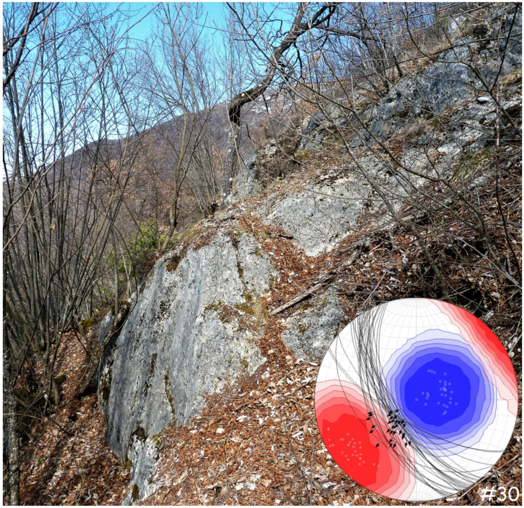
Figure 3.
Shaded relief map of the Norcia area evidencing the faulted relic top-surface of the Late Pleistocene-post Last Glacial Maximum (>14–12 ka) alluvial fan of Patino (stars, 14C dated paleosols). Note the NW-SE graben-like structure that downthrows the western nail of this fan (red dotted line indicate the 2016 re-activation), and the Norcia master fault traversing its apex. T1–10 are the paleoseismological trenches in [23]. Green, Meso-Cainozoic, marine carbonate basement. Gray, other Quaternary slope and alluvial deposits (Middle Pleistocene-Holocene).

Figure 4.
View looking northeast of the scraped fault-scarp hosting the limekiln (right-center). The kiln was set inside the Scaglia variegata formation (Eocene) and in brownish colluvia (Late Holocene). The yellow arrows indicate the low-angle intersection between the fault plane (N110°) and the undulated outcrop front. Panel (A) is a blow-up of the remnant of the striated slickenside in the Scaglia variegata marls.
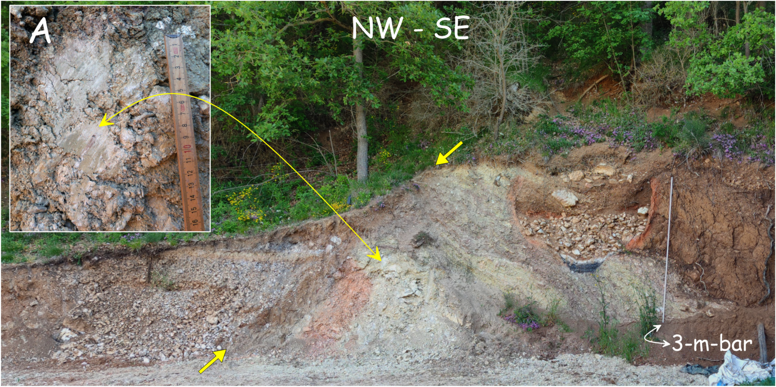
Figure 5.
View looking northwest of the fault scarp and of the carbonate slickenside close to the kiln. The fault here juxtaposes marine limestone against cemented slope debris.
Figure 5.
View looking northwest of the fault scarp and of the carbonate slickenside close to the kiln. The fault here juxtaposes marine limestone against cemented slope debris.

Figure 6.
Sketch of the limekiln and 14C ages of selected samples. Legend as in Figure 7.
Figure 6.
Sketch of the limekiln and 14C ages of selected samples. Legend as in Figure 7.
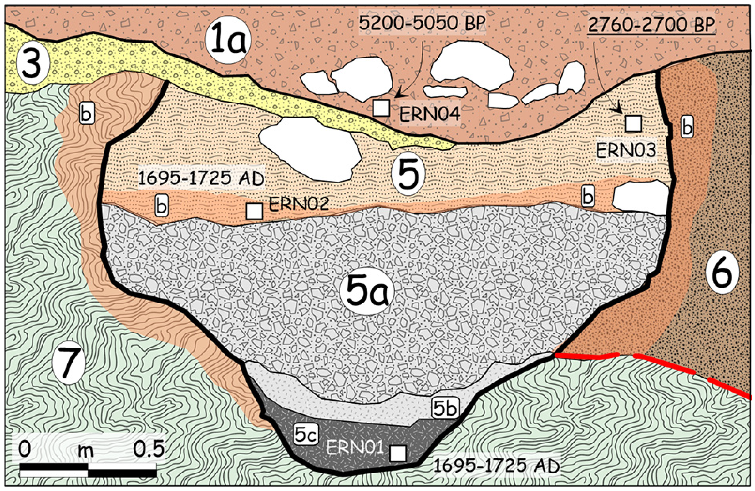
Figure 7.
View looking northeast of the limekiln outcrop paralleling the Norcia master fault (see also Figure 4). Legend: 1: sandy gravel (colluvial wedge); 1a: sandy coarse gravel with boulders (channeled debris flow); 2: open-work gravel with charcoals and tiles; 3: yellowish gravel (traction-carpet sheetflood debris): 4: man-made stones heap; 5: sandy seal of the kiln; 6: slope colluvia; 7: Scaglia variegata Formation. The vertical yellow arrow suggests the real offset value of Unit 3 bottom (1.1 m), which appears larger than 2 m in this sketch without the slope correction (see text).

Figure 8.
Schematic cross section of the faulted limekiln (legend same as Figure 7). In the hanging-wall, level 3 is projected in the plane-section in order to highlight its vertical offset (see Figure 7). The rear wall of the kiln (b) is speculative.


Table 1.
Laboratory ages of samples considered in the study. AMS, accelerator mass spectrometry (Beta Analytic Inc., Miami, FL, USA). 2σ calibration with software Calib 6.0.1 [31].
Table 1.
Laboratory ages of samples considered in the study. AMS, accelerator mass spectrometry (Beta Analytic Inc., Miami, FL, USA). 2σ calibration with software Calib 6.0.1 [31].
| Site | Sample | Laboratory | Analisys | Dated material | δ13C | Conventional Age (BP) | Preferred 1σ Pick | 2σ cal. 95% |
|---|---|---|---|---|---|---|---|---|
| Limekiln | ERN-01 | BETA-596983 | AMS | Charred material | −24.4 | 40 ± 30 | 1695–1725 AD | 1694–1917 AD |
| Limekiln | ERN-02 | BETA-596984 | AMS | Charred material | −25.7 | 10 ± 30 | 1695–1725 AD | 1695–1916 AD |
| Limekiln | ERN-03 | BETA-596985 | AMS | Organic sediment | −25.1 | 2580 ± 30 | 2760–2700 BP | 25,230–2760 BP |
| Limekiln | ERN-04 | BETA-596986 | AMS | Organic sediment | −24.6 | 4510 ± 30 | 5200–5050 BP | 5048–5304 BP |
| Limekiln | ERN-06 | BETA-596987 | AMS | Charred material | −27.7 | 60 ± 30 | 1700–1720 AD | 1693–1918 AD |
| Limekiln | ERN-07 | BETA-596988 | AMS | Charred material | −24.9 | 100 ± 30 | 1695–1725 AD | 1683–1936 AD |
| Patino fan | AGRVIGN | BETA-596989 | AMS | Organic sediment | −24 | 12,140 ± 30 | 14,107–13,993 BP | 13,870–14,107 BP |
| Patino fan | TOPATINO01 | BETA-518966 | AMS | Organic sediment | −24.2 | 10,360 ± 30 | 12,390–12,055 BP | 12,055–12,390 BP |
Publisher’s Note: MDPI stays neutral with regard to jurisdictional claims in published maps and institutional affiliations. |
© 2021 by the authors. Licensee MDPI, Basel, Switzerland. This article is an open access article distributed under the terms and conditions of the Creative Commons Attribution (CC BY) license (https://creativecommons.org/licenses/by/4.0/).
Share and Cite
MDPI and ACS Style
Galli, P.; Peronace, E.; Messina, P. Archaeoseismic Evidence of Surface Faulting in 1703 Norcia Earthquake (Central Italian Apennines, Mw 6.9). Geosciences 2022, 12, 14. https://doi.org/10.3390/geosciences12010014
AMA Style
Galli P, Peronace E, Messina P. Archaeoseismic Evidence of Surface Faulting in 1703 Norcia Earthquake (Central Italian Apennines, Mw 6.9). Geosciences. 2022; 12(1):14. https://doi.org/10.3390/geosciences12010014
Chicago/Turabian StyleGalli, Paolo, Edoardo Peronace, and Paolo Messina. 2022. "Archaeoseismic Evidence of Surface Faulting in 1703 Norcia Earthquake (Central Italian Apennines, Mw 6.9)" Geosciences 12, no. 1: 14. https://doi.org/10.3390/geosciences12010014
Note that from the first issue of 2016, this journal uses article numbers instead of page numbers. See further details here.