


Frasassi Caves and Surroundings: A Special Vehicle for the Geoeducation and Dissemination of the Geological Heritage in Italy

School of Sciences and Technologies, Section of Geology, University of Camerino, Via Gentile III da Varano, 62032 Camerino, Italy
*
Author to whom correspondence should be addressed.
Geosciences 2022, 12(11), 418; https://doi.org/10.3390/geosciences12110418
Submission received: 27 September 2022
/
Revised: 5 November 2022
/
Accepted: 8 November 2022
/
Published: 12 November 2022
(This article belongs to the Special Issue Geoheritage and Geotourism Resources: Education, Recreation, Sustainability II)
Abstract
:One of the most fascinating aspects of the work of geologist lies in knowing how to read the physical landscape as an expression of the geological and geomorphological phenomena that shaped the Earth’s relief over time. The necessity to disseminate these vast areas of knowledges and skills starts from here, with the aim to enhance the concept of geodiversity and to raise awareness for its protection and promotion. This work aims to share some examples of projects realized following the subscription of agreement between different public authorities in the Apennine territory of Marche Region in Italy, such as the Geology Section of the University of Camerino (MC), “Consorzio Frasassi” (which manages the underground karst complex of Frasassi caves) and municipality of Genga (AN), where Frasassi caves are located. Thanks to this partnership, our research group realized didactic geological notebooks for school groups visiting the caves and interactive museum laboratories in 3D, showing the geological evolution of the area. This sharing of knowledge will contribute to educate communities about the importance of the geological heritage. At the same time, this project can serve as motivation to establishing the same type of collaborations in those territories where similar projects can be replicated.
1. Introduction
The geologist is the only professional figure who does not focus only on the external appearance of a physical landscape. He asks why, where, when, and how that landscape formed and which geological and geomorphological processes created it. He doesn’t stop on the mere observation of the outer portion of the Earth’s crust, but rather penetrate it in depth, understanding why there may be mountains or plains on the surface. A geologist can reconstruct how the arrangement and the nature of rocks vary underground, identifying the presence of folds, faults, fossils, minerals, and aquifers, and thus determining the presence of water, applying their own knowledge towards something essential for the sustainability of life.
Therefore, there is vital importance in sharing this knowledge and explaining even the most fascinating and complicated processes in the best possible way in order to involve and arouse interest in students, scientists, and researchers, as well as tourists and simple passionate people.
The study area is contained within the regional natural park named “Parco Naturale Regionale della Gola della Rossa e di Frasassi”, a protected area of 10,026 hectares instituted in 1997 and considered an extraordinary example of geological, biological, historical, and cultural heritage [1,2]. This is also the location of the hypogeum complex of Frasassi caves, in the Apennine territory of Marche Region, under the municipality of Genga (AN), within the Mount Valmontagnana, in the southern side of Frasassi gorge. Frasassi gorge is a fluvial incision with a W–E direction cut by Sentino River during the Quaternary period. Frasassi caves began to form in this period, when this portion of Apennine emerged above sea level, and continental processes (fluvial erosion and karst phenomena) began to incise the gorge and create the hypogeum complex. The underground cave network is composed of tunnels and pits and develops within the rocky walls in Calcare Massiccio Formation constituting the gorge, in an altitude range between 200 and 500 m. a.s.l. The karst tunnels are arranged on at least four main levels, the evolution of which is linked to standstill and deepening phases of the surface hydrographic network. The lower and most recent levels, between 200 and 300 m. a.s.l., probably originated in the middle Pleistocene and late Pleistocene periods, as indicated by the correlations with the terraced alluvial deposits [3] and by the dating of speleothems, with ages reaching 200,000 years old [4].
The incision of Frasassi gorge also acted by cutting the local sedimentary succession, representing about 120 million years; that is, from the lower Jurassic of the “Calcare Massiccio” Formation to the upper Cretaceous of the “Scaglia Rossa” Fm., outcropping on the top of Monte Vallemontagnana (southern side of the gorge). This interval of time is represented in about 600–700 m of the straight walls of the gorge, along which many geosites are recognizable, collected (with stars symbolism) in a map showing their distribution as well as other places of historical, religious, and cultural interest (Figure 1).
The locality of Frasassi is not only famous for its touristic caves, but also for its territory, where nature has greatly shaped the geomorphological landscape. In this area, in fact, there are many other tourist attractions (epigean caves, rocky slopes, fossil sites, rivers, waterfalls, sulfur springs, and thermal waters) that provide suitable conditions to appreciate the cultural heritage (many abbeys and hermitages are set in the caves and built with local stones), climbing (each year, the Frasassi climbing festival is organized), trekking and bike riding (in Frasassi caves and along the countless mountain trails), running (each year, the Frasassi sky race is organized), fishing (with carp, trout, chub, and perch), bird watching (eagles nest along the vertical walls of the gorge), and relaxing facilities (river baths and thermal structures). All of these attractions are guided by a common thread by which they have been originated and shaped: geology. Further, geology strictly conditioned the subsequent anthropization of this territory, from prehistoric times to today.
The awareness of the large geodiversity of the Frasassi area laid the groundwork for the subscription of an agreement between three authorities: “Consorzio Frasassi”, “Geology Section of University of Camerino”, and “Municipality of Genga”, with the aim to preserve, disseminate, and promote the enormous geological heritage of the area. On the one hand, this would have allowed “Consorzio Frasassi” and “Municipality of Genga” to deepen the geological knowledge of the area, counting on academic skills; on the other hand, it would have allowed the Geology Section of University of Camerino to facilitate the dissemination of geological sciences to a wider audience, allowing greater visibility (thanks to the around 250,000–300,000 annual visitors, between tourists and school groups).
The two case studies realized and illustrated in this work aim to explain the extraordinary geodiversity of Frasassi caves and surroundings to school groups and tourists. For the dissemination of the geological, geomorphological, and karst evolution of the territory of Frasassi and its geological heritage, together with the other signatory partners of the agreement, it was decided to set up two geo-educational projects:
- -
- Field laboratory with the use of didactic geological notebooks (for school groups visiting the caves);
- -
- 3D interactive museum with virtual reality geological laboratories.
These two realized projects involve geo-products as a tool for geo-education [5], with a large didactic potential [6]. However, at the time of drawing up this article, the bibliography does not provide many similar projects in the international context, in terms of both activities with didactic geological notebooks and 3D interactive museum geological laboratories.
Through these two different projects, school groups and students can be brought closer to the understanding of the phenomena that generated the geological wonders of the territory, facilitated by “field teaching” and by original tools capable of effectively involving them (in both paper and digital form). The aim of this work is to recognize, review, and evaluate the usefulness of geo-cultural features in in terms of didactics.
2. Materials and Methods
Among the most important objectives of “Consorzio Frasassi”, the institution that opened the cave to the public in 1973 and manages it, there is undoubtedly the desire of deepen the scientific aspects of the underworld, being aware that the enhancement, protection, and promotion of the geological heritage can be pursued only through a deep knowledge of the phenomena and laws that regulate the planet Earth. School groups are a very important target for “Consorzio Frasassi” because, each year, almost 70,000–80,000 students visit Frasassi caves, out of a total of approximately 250,000–300,000 visitors per year (data found on the official website of “Consorzio Frasassi”). In this regard, “Consorzio Frasassi” is in constant contact with schools and tour operators to attract school groups and tourists to its underground complex. On the other side, the University of Camerino is always looking for opportunities to disseminate the importance of its courses of study (in this case, Earth Sciences).
Thanks to the sharing of knowledge with the academic environment of the Geology Section of the University of Camerino, it was possible to deepen the studies and enhance the informative and educational aspects, which is very useful for students but also interesting for tourists.
Frasassi gorge shows a large variety of geosites concentrated in a rather small area. For this reason, during some characterizations of the area [2], it is interpreted as an “areal geosite”, composed of more than one punctual geosite. In this work, it has not been necessary to provide a characterization of every single geosite but, in order to characterize the geosite from a qualitative point of view (Table 1), we decided to rely on international examples known in the bibliography. For this reason, we chose the geosite of Frasassi caves to represent the area. The selection of the case considered one criterion; that is, whether they are or have been in the process of patrimonialization (in this case an UNESCO candidacy). We modified the table provided by the authors of [7] for our case study.
For this reason, it was decided to implement the didactic aspects by offering immersive experiences, an experiential approach conducted both directly in the cave (through didactic geological notebooks) and via digital means through mobile apps and 3D viewers (3D interactive museum geological laboratories).
These two approaches can be considered, in a certain way, as opposite but complementary. This is because the first aspect, the activity with didactic geological notebooks, represents the practical experience on the field, where students will literally dive into an underground environment; that is, they will enter in the cave, get dirty and wet, use paper, write with a pen and draw on the didactic notebook. The second aspect, the 3D interactive museum geological laboratories, represents the actual, digital period, where students will have an immersive but still detached experience through virtual reality. If, on the one hand, they will not be practically involved, on the other hand, they will fly through the landscape, having the possibility to observe it from another prospective. This experience is equally formative because, during the 3D travel at 360°, it will be possible to interact with items scattered along the surroundings of Frasassi, deepening the encountered topics. This activity also includes a final multiple-choice quiz, useful to fix the acquired knowledge.
These two realized solutions represent an effective approach to explain the complex phenomena that regulate geology, trying to transmit knowledge in the best possible way. This is possible because, in this territory, we are lucky to be able to closely observe and address a myriad of exemplary geological features and situations, so as to be able to understand the processes responsible for their origin. Thanks to this unique possibility offered to us by nature, the idea of enhancing this potential was born, leveraging immersive, experiential tourism.
The didactic geological notebooks were conceived, designed, and realized for lower secondary schools (in Italy called “scuola secondaria di primo grado”, once known as “scuola media”). They were drawn up in Italian language, because Frasassi caves work almost entirely with Italian schools.
Didactic geological notebooks aim to represent a practical opportunity to deepen the topics covered in the classroom and during the experience inside the Frasassi caves. Thanks to the highly interactive mould attributed to them, didactic geological notebooks can be considered a real open-air laboratory (in this case, an underground laboratory). They were set up following a trail allowing to closely admire and understand rocks, structures, and landforms originated and modelled thanks to eternal and tireless geological processes.
An extremely informative, colloquial, and novelized approach was chosen for the drafting of the text, as the target is represented by students aged between 11 and 14. Therefore, we simulated that the students could play the role of a real explorer, a speleologist who will have to orient themselves in the cave with the support of a map, to be completed with the recognized elements (stalactites, stalagmites, columns, landslides, and so on) along the path. Yes, because, to become a true speleologist, students must first be able to read the landscape that surrounds them and know how to orient themselves even in environments that are very different from those with which they are familiar.
The active involvement of students in this educational trail represents a strong element of the proposed planning, convinced (empirically) that the consolidation of knowledge and understanding of the phenomena are facilitated by direct observation and experiences gained in the field.
The second project is under realization at the museum “Art, history, and territory” of the village of Genga. “Consorzio Frasassi” asked the University of Camerino to offer its scientific support to create an interactive, three-dimensional, immersive instrument at 360° with augmented reality. The Geology Section of University of Camerino provided a document called “Frasassi: water and geology”, where all geological aspects were treated with to the leitmotif of water. Water, in fact, is responsible for the creation of rocks, for the modeling of the territory, for karst and speleogenesis, and for anthropic settlements. It is also a risk and a resource for each territory. All of these topics were treated in the document, which constitutes the backbone of the project, the loom on which to shape and develop the interactive 3D laboratories with augmented reality.
This activity foresees the 3D interactive scenario and is suitable for a much wider audience of recipients, not only school groups but also university students, tourists, and passionate common people.
The project consists of a 3D and 360° panorama of Frasassi gorge, acquired by a special drone and viewable by the user from above (Figure 2). The scenario is interactive. It is based on a 3D virtual reality with immersion of 360°, and users can view the panorama of the Frasassi surroundings while flying, zooming, and interacting where they want. Images were acquired through a special drone, an octocopter with eight propellers for the support of Titan cameras, with an overall resolution of 11 k.
This digital content allows for online visiting of caves and the area around the caves by people who, because of health reasons, cannot do so in reality. Therefore, it will be an instrument to show the landscape from above that is useful for people with disabilities.
3. Results
As mentioned previously, the great intuition for the two projects under consideration lies in the possibility of providing to school groups or tourists a wide range of offers, depending on the type of experience they need; that is, the activities through didactic geological notebooks are an “in the field” experience, where students go in the cave, see the phenomenon with their eyes, and can direct enjoy the experience. Contrariwise, the 3D interactive museum geological laboratories represent, in a certain sense, the necessary digital innovation desired today by the users.
These are two completely different types of didactic approaches, but we believe that they are both experiences that should be engaged in, as one represents the completion of the other. Both activities will be illustrated in the following pages, although one should refer to the Supplementary Materials for specific details.
3.1. Didactic Geological Notebooks for School Groups Visiting the Caves
The didactic geological notebooks were attached as Supplementary Materials to the present work.
Two different types of didactic notebooks were realized: one for teachers and guides of the Frasassi caves and the other one for students, accompanied by the map of the explorable cave in plan view (Figure 3). The first one (“Guida al quaderno didattico”) is designed to instruct teachers and guides on how to hold the didactic lesson in the cave, as they will then be the ones to guide and question the students. The second one (“Il taccuino del giovane speleologo”) is considered the real didactic notebook for students and is composed of three sections: an initial didactic, a second related to the experience, and a third in which we will try to fix some key concepts of the experience in a lighter manner.
The first part of “Il taccuino del giovane speleologo” concerns the theory. It must be dealt with in the classroom as an extra didactic activity or during the visit to the Frasassi cave. Therefore, in the text, the following is explained: what a cave is, how the water is able to dissolve the limestone rock, how extensive the Frasassi caves are, if there is water in them, what structure the caves have, when they were formed, why in the cave we find gypsum deposits, why concretions are formed and how much they grow every year, and which organisms live in the cave. The topics that can be treated in the cave are practically a myriad: geology, sedimentology, stratigraphy, speleology, topography, cartography, hydrogeology, karst, structural geology, geomorphology, palaeontology, and speleobiology. As sciences, these disciplines are obviously based on the laws of chemistry, physics, and mathematics. The added value of educational notebooks in the cave thus lies in the fact that they offer an experiential visit with a high multidisciplinary content.
The second part of the didactic geological notebook represents the real activity, with practical exercises. It was conceived as an exploratory adventure and, for this reason, the cover has been given the appearance of an explorer’s notebook, in A5 format, with the cartography map as a central insert in A3. This map is the “beating heart” of the experience, because all of the activities are based on it and it is also a useful tool to encourage students to take their first steps in orienteering.
We stated that the activity in the cave would be a real exploration, so we decided to reproduce the cartography of the cave in plan view, as a sort of ancient map, similar to a treasure map. Here, the pathway is traced and the stops at which the various activities are planned are indicated with crosses. There are five exercises. Each one requires at least 5–10 min of time for illustration and resolution, and the total foreseen time for a standard visit to the caves will add up to almost 2 h.
The first exercise will take place at stop 2 of the tour and will encourage students to become familiar with the map. They will orient the cartography with the north arrow and they will trace in it the rockfall deposit in the “Abisso Ancona” (the largest underground environment of the Europe caves) and some gypsum deposits (trying to respect the scale and dimensions).
A further method of representing the environment is the sectional one. In the second exercise (stop 3 of the tour), it will be possible to observe a north–south section of the “Abisso Ancona” (Figure 4). Based on some known points shown in the image, students must draw some surrounding elements, such as geological strata, rockfall deposits, principal stalactites, and the stalagmites known as “I Giganti”. Older students may be further asked to be careful to maintain the correct proportions of scale.
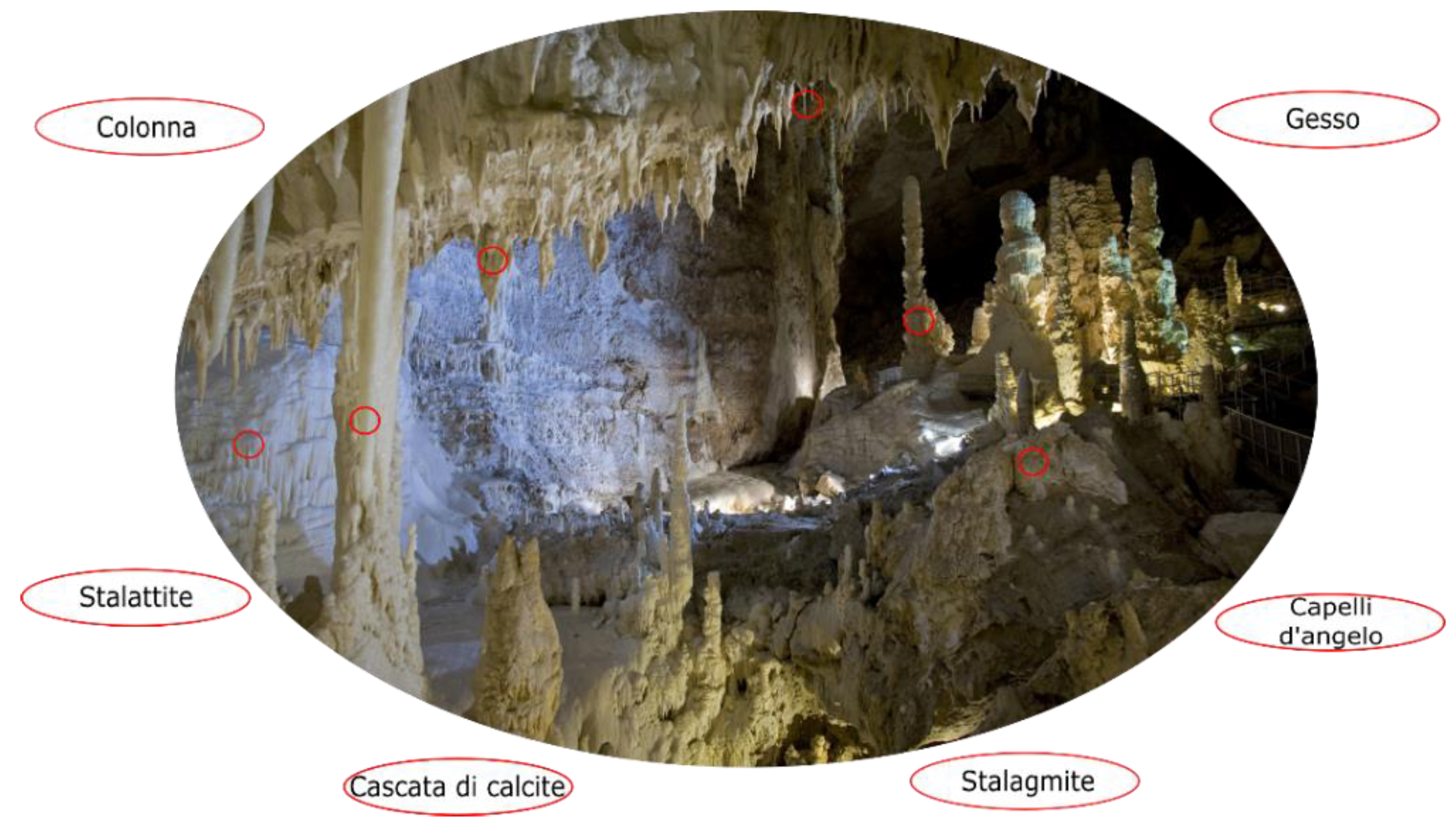
The third exercise (Figure 5) refers to stop 4 of the tour. In this situation, students must connect, using an arrow, the exact terms with the elements they see in the photo of Figure 4. To help themselves, they can observe the image and make direct comparisons with what they see in front of their eyes.
This stop also has another exercise; in this case of geometry, the “Abisso Ancona” in plan view is similar to a square. Based on the scale bar on the map, students will have to calculate the approximate perimeter and area. In this way, they will understand that geology also involves mathematics and geometry.
The fourth experience was designed for adult students and is located at stop 7; this point is one of the very rare occasions in which it is possible to observe a fault directly from inside the mountain. By putting the point on paper and joining it with a straight line with another point where the fault is visible, the students will learn to draw a fault line on the map.
The last activity is designed for younger school children. It will be found at stop 9, the last portion of the cave. School children will have to keep their eyes open for what is considered the cave’s real treasure: the eccentric stalactites (Figure 6). These are very peculiar concretions—they often form curls that can even develop upwards, defying gravity.
The last, relaxing exercises aim to fix the key concepts through a crossword puzzle and a cryptogram (Figure 7). These may be considered simple exercises, but they are formative and fixative of the concepts learned in the cave.
All of these exercises are designed to promote geology, bringing students closer to Earth Sciences. The map in plan view will stimulate young students to orient themselves in the space, with the difference that, unlike the external environment, the reference points and objects used to orient oneself will be completely different, as well as the perception of distances. Based on the morphology of the cave (the shape of the walls or vaults), on a particular speleothem (stalactites, stalagmites, columns, curtains, draperies, and so on), in the presence of particular sediments (such as gypsum, a rockfall deposit, or a fossil-rich sedimentary level), rather than in the presence of groundwater, the students will observe in detail the cave, with a very keen eye on those elements useful for their orienteering.
3.2. 3D Interactive Museum Geological Laboratories
At this moment, it is not possible to provide a video representation of 3D interactive museum geological laboratories, because the work has been completed, but has not yet been set up in the museum.
In this second realized project, the 3D interactive museum geological laboratories, the activity aims to provide an immersive visual experience, which is currently being assembled at the museum “Art, history, and territory” of Genga. The acquired 360° landscape can be viewed on a monitor or through the use of a mobile app, and the 3D visualization is possible thanks to Oculus Quest viewers, provided by the museum. This typology of geo-education represents an example of STEM education, a teaching approach that combines Science, Technology, Engineering, and Math [8].
In addition to showing the whole landscape from above and allowing detailed zooms, the activity can be considered as a journey that accompanies the user through the geological history of the Frasassi area. Through accurate geological sections and 3D modeling, it has been possible to reproduce the paleoenvironments in which rock formed and evolved (Figure 8 and Figure 9). This aspect is fundamental, because, through paleoenvironmental animations (Figure 10), it was possible to simulate the geological processes that accompanied rocks from the Jurassic period to the current day and that, following the emergence above sea level, have led to the geomorphological shaping of the relief and to the formation of underground cavities (even if sometimes, owing to technical limitations, it was not possible to replicate the precise evolution).
By modeling these environments, maximum attention was paid to details; therefore, it was sometimes necessary to model the marine organisms that populated the sea in the Jurassic and, today, we find fossils, such as ammonites, cuttlefishes, squids, and ichthyosaurs (Figure 11). Yes, ichthyosaurs, because the well preserved three-meter holotype of Jurassic Gengasaurus Nicosiai, found a few hundred meters from the caves in the 1970s, is kept in the speleo-paleontological museum of San Vittore.
4. Discussion
The dissemination of scientific heritage, using well-known and appreciated topics, could represent one of the new goals of Earth Sciences [9]. The examination of some of the dramatic events that have occurred in Italy related to its geo-environmental setting and the effects of interaction with anthropogenic pressure reveals the need to provide the general public with correct and clear information about the complex scenario characterizing this country [10].
The landscape plays a key role in communication and knowledge processes; it is the aspect of the environment that people perceive and with which they interact. The project’s strategy is to involve the various social components, relying on unconventional and intergenerational communication, and to encourage active, extensive, effective, and lasting participation in risk prevention and sustainable resource enhancement activities. The tactics involve a range of methods that make scientific issues first accessible and then intriguing, until they become engaging. Communication is the medium and message [11]. Departure, path, and arrival are considered. In this regard, the use of topics more appealing to the general public as vectors of scientific concepts is a successful strategic solution when trying to share complex, or simply unpopular, concepts, information, or regulations. An effective tactic is to provide “unexpected” information through unconventional channels and to invite prominent figures to be actively involved as testimonials [12].
The extraordinary geo-environmental and cultural landscape that characterizes Italy is a powerful means of communicating territorial issues to all of society. Landscapes, if recognized and understood, become part of everyone’s cultural heritage and reveal the dynamics that characterize their natural history, on the basis of the aforementioned “risk/resource” combination, providing the observer with knowledge indispensable to understanding complex environmental realities [13].
It is in this sense that the very perception of the landscape is the basis of a cognitive process that can trigger a virtuous circle, which revitalizes the roots that bind man and the environment, fostering more creative participation of society in balanced land management and sustainable development.
These projects were partially realized in an experimental manner, reaching an encouraging involvement of the local communities. A desirable outcome would be that the project will achieve further institutional support in order to be implemented.
The didactic geological notebooks were tested during their drafting through constant discussions with the administrations involved (Geology Section of the University of Camerino, Consorzio Frasassi, Municipality of Genga). In April 2022, a specific educational meeting was also organized with about 60 teachers from all over central Italy and the most experienced guides of the cave. On this occasion, the whole project was presented, because guides and teachers need to know the correct way to disclose it to students. Each aspect of the didactic notebooks was illustrated directly in the cave, in order to become familiar with the project, to know its facets, and to understand the best way to apply it by stimulating children during the experience in the cave. The reviews collected have been almost totally positive, although making people from other sectors understand the mechanisms that regulate Earth Sciences is not easy.
The 3D interactive museum with virtual reality geological laboratories is under construction, although we can count on positive reviews from insiders (geologists, graphic designers, local administrators, and marketing staff of the caves). The final realization will presumably take place in November 2022.
The use of innovative digital software in the framework of education has many barriers. Among them, the high cost of equipment for organizing the educational space, the need for additional competencies of the teaching staff [14], and the use of students’ personal devices to ensure successful group interaction [15]. During this activity, special Oculus Quest viewers will be provided to the students in order to implement the 3D vision and the immersion in the environments reproduced at 360°.
5. Conclusions
The territorial proximity between the premises of Geology Department of Camerino and the Frasassi caves stimulated collaboration between the public bodies, united by geological excellence. This represents an element of strength on which to set up projects capable of disseminating the importance of Earth Sciences and the figure of the geologist. The environmental context facilitates teaching in the field and geo-education, above all thanks to the welcoming structures offered by the district. Here, in fact, starting from the 1970s, the tourist reception has undergone great development, and now the territory is able to accommodate large numbers of school groups (around 80,000–90,000 per year).
Several characteristics provide the mountain environment areas with great potential for geoheritage, geoconservation, and geotourism studies [16], creating the best conditions for geo-education. The underground karst complexes, in fact, have always attracted the curiosity of people, arousing in them sublime feelings of attraction and repulsion. In Frasassi, the attractive effect of the hypogeum complex is amplified because the fascinating caves are located inside a breathtaking gorge, characterized by steep slopes that are hundreds of meters high, hosting the lively Sentino River, embedded at their feet. These features are fundamental to enrich the fascinating landscape in which it is possible to recognize the impressive geomorphological elements and to observe the processes (active and well understood) that condition their development.
For all of these reasons, geomorphosites (especially mountain ones) seem to be particularly interesting sites for developing educational activities on environmental issues [17]. All of these elements inspire attendance by school children, stimulating outdoor experiential teaching that facilitates the understanding of phenomena. The outdoor didactic is seen as a moment of leisure, an unusual method of teaching that is original and able to capture the attention of scholars.
The hope is that, thanks to the projects carried out and illustrated in this work, other virtuous behaviors can be established in other territories, thanks to their replicability in other contexts (although the conditions are not present in all of them).
Supplementary Materials
The following supporting information can be downloaded at https://www.mdpi.com/article/10.3390/geosciences12110418/s1. Quaderno didattico_Guida docenti: Guida al quaderno didattico; Quaderno didattico_Studenti: Il taccuino del giovane speleologo; Quaderno didattico_Mappa.
Author Contributions
Writing—original draft preparation, F.B.; writing—review and editing, P.F.; supervision, P.F. All authors have read and agreed to the published version of the manuscript.
Funding
This research received no external funding. The two projects of the didactic geological notebooks for school groups and the 3D interactive museum with virtual reality geological laboratories were founded by “Consorzio Frasassi”. The authors and the Geology Section of the University of Camerino provided the project idea and the scientific support necessary for its realization, which was edited under a graphic and technological (modelling) point of view by “Brugiatelli Design”, Serra de’ Conti (AN), Italy and “L.D. Multimedia s.r.l.”, Moncalieri (TO, Italy).
Data Availability Statement
Not applicable, no data were used for this article.
Acknowledgments
It is our duty to thank professor Emanuele Tondi for having allowed the realization of the two projects providing, as usual, very useful original ideas. The paleontologist Marco Peter Ferretti for the support offered in the modeling of Jurassic organisms; Sandro Galdenzi for the precise indications relating to the didactic notebooks; the archeologist Gaia Pignocchi for the archeological consultancy; and the entire working group that contributed to the creation of the 3D interactive museum with virtual reality geological laboratories, which, in addition to the authors of the present article, is composed of Claudio Di Celma, Marco Peter Ferretti, Sandro Galdenzi, Maria Chiara Invernizzi, Danica Jablonska, Marco Materazzi, Stefano Mazzoli, Pietro Paolo Pierantoni, Emanuele Tondi, and Tiziano Volatili. Finally, we would like to thank Marco Filipponi and David Bruffa of the Municipality of Genga; and Lorenzo Burzacca, Maurizio Tosoroni and Sara Bonacucina of the “Consorzio Frasassi” for allowing us to apply our knowledges and our projects to their caves and their territory, making them available for school groups, citizens and tourists.
Conflicts of Interest
The authors declare no conflict of interest.
References
- Farabollini, P.; Spurio, E.; Aringoli, D.; Chiarini, C.; Kardos, E. I Quaderni del Parco, N.8—Geositi e Geoescursionismo nel Parco Naturale della Gola della Rossa e di Frasassi; Comunità Montana dell’Esino-Frasassi, Parco Naturale della Gola della Rossa e di Frasassi: Serra San Quirico, Italy, 2007. [Google Scholar]
- Alessandroni, G.; Bendia, F.; Farabollini, P.; Gennari, E.; Nesci, O.; Tatali, B.; Valentini, L. I Geositi delle Marche—Un patrimonio di geodiversità di eccezionale valore. Presentazione risultati Gruppo di Lavoro SIGEA-APS Marche, Università di Urbino, Università di Camerino, Ordine Geologi Marche. In Proceedings of the Workshop I Geositi delle Marche, Ancona, Italy, 26 May 2022. [Google Scholar]
- Bocchini, A.; Coltorti, M. Il complesso carsico Grotta del Fiume Grotta Grande del Vento e l’evoluzione geomorfologica della Gola di Frasassi. Mem. Ist. It. Speleol. 1990, 4, 155–180. [Google Scholar]
- Taddeucci, A.; Tuccimei, P.; Voltaggio, M. Studio geocronologico del complesso carsico “Grotta del Fiume-Grotta Grande del Vento” (Gola di Frasassi, AN) e indicazioni paleoambientali. Il Quat. 1992, 2, 213–222. [Google Scholar]
- Dryglas, D.; Miśkiewicz, K. Construction of the geotourism product structure on the example of Poland. In Proceedings of the 14th International Multidisciplinary Scientific GeoConference SGEM 2014, Albena, Bulgaria, 17–26 June 2014; Volume 3, pp. 155–162. [Google Scholar]
- Miśkiewicz, K. Promoting geoheritage in geoparks as an element of educational tourism. In Geotourism. Organization of the Tourism and Education in the Geoparks in the Middle-Europe Mountains; Szponar, A., Toczek-Werner, S., Eds.; University of Business in Wrocław: Wrocław, Poland, 2016; pp. 37–48. [Google Scholar]
- Hueso-Kortekaas, K.; Iranzo-García, E. Salinas and “Saltscape” as a Geological Heritage with a Strong Potential for Tourism and Geoeducation. Geosciences 2022, 12, 141. [Google Scholar] [CrossRef]
- Shakirova, N.; Said, N.; Konyushenko, S. The use of virtual reality in geo-education. Int. J. Emerg. Technol. Learn. (iJET) 2020, 15, 59–70. [Google Scholar] [CrossRef]
- Farabollini, P.; Lugeri, F.R.; Amadio, V.; Aldighieri, B. The role of Earth Sciences and Landscape Approach in the Ethic Geology: Communication and Divulgation for the Prevention and Reduction of Geological Hazards. In Engineering Geology for Society and Territory; Lollino, G., Arattano, M., Giardino, M., Oliveira, R., Peppoloni, S., Eds.; Springer: Berlin/Heidelberg, Germany, 2014; Volume 7, pp. 115–120. [Google Scholar]
- Lugeri, F.R.; Farabollini, P.; Amadio, V.; Greco, R. Unconventional Approach for Prevention of Environmental and Related Social Risks: A Geoethic Mission. Geosciences 2018, 8, 54. [Google Scholar] [CrossRef] [Green Version]
- McLuhan, M.; Fiore, Q. Il Medium è il Massaggio; Editore Corraini; Penguin Books: London, UK, 2011; p. 160. ISBN 8875702861. [Google Scholar]
- Lugeri, F.R.; Farabollini, P.; De Pascale, F.; Lugeri, N. PPGIS applied to environmental communication and hazards for a community-based approach: A dualism in the Southern Italy ‘calanchi’ landscape. AIMS Geosci. 2021, 7, 490–506. [Google Scholar] [CrossRef]
- Panizza, M.; Piacente, S. Geomorphosites: A bridge between scientific research, cultural integration and artistic suggestion Geomorphological sites and geodiversity. Il Quat. 2005, 18, 3–10. [Google Scholar]
- Zeer, E.F.; Tretyakova, V.S.; Miroshnichenko, V.I. Strategic Directions of Pedagogical Personnel Training for the System of Continuing Vocational Education. Educ. Sci. J. 2019, 21, 93–121. (In Russian) [Google Scholar] [CrossRef] [Green Version]
- Ezrokh, Y.S. HR Perspectives of Russian Universities: Who Will Teach in the Near Future? Educ. Sci. J. 2019, 21, 9–40. (In Russian) [Google Scholar] [CrossRef] [Green Version]
- Giusti, C.; Reynard, E.; Bollati, I.; Cayla, N.; Coratza, P.; Hoblea, F.; Ilies, D.; Martin, S.; Megerle, H.; Pelfini, M.; et al. A new network on mountain geomorphosites. Geophys. Res. Abstr. 2013, 15, EGU2013-6706. [Google Scholar]
- Reynard, E.; Coratza, P. The importance of mountain geomorphosites for environmental education: Examples from the Italian Dolomites and the Swiss Alps. Acta Geogr. Slov. 2016, 56, 291–303. [Google Scholar] [CrossRef]
Figure 1.
An excerpt of the map attached in “I Quaderni del Parco, N.8—Geositi e Geoescursionismo nel Parco Naturale della Gola della Rossa e di Frasassi” [1], with the geosites and historical/cultural places indicated along the Frasassi gorge (the red star in the overview map indicates its location). The coordinate grid and the scale bar are shown in the original map.

Figure 2.
Panoramic view of the Frasassi gorge at 360°, captured by the drone used for 3D virtual reality.
Figure 2.
Panoramic view of the Frasassi gorge at 360°, captured by the drone used for 3D virtual reality.

Figure 3.
The two notebooks (one for teachers and guides and the other for students) with the map of the cave and the real scenario for the activities.
Figure 3.
The two notebooks (one for teachers and guides and the other for students) with the map of the cave and the real scenario for the activities.

Figure 4.
The second activity with a representation of the cave “Abisso Ancona” in the section.

Figure 5.
The third activity, where the elements visible in the cave must be connected with their names.
Figure 5.
The third activity, where the elements visible in the cave must be connected with their names.

Figure 6.
The eccentric stalactites in “Sala dell’Infinito”. As it is possible to see, they are growing upwards.
Figure 6.
The eccentric stalactites in “Sala dell’Infinito”. As it is possible to see, they are growing upwards.

Figure 7.
The last exercises of the didactic geological notebooks.

Figure 8.
A schematic geological section used for animated modeling of the Jurassic paleoenvironment. During the animation, the activation of normal faults and the prosecution of sedimentation are shown.
Figure 8.
A schematic geological section used for animated modeling of the Jurassic paleoenvironment. During the animation, the activation of normal faults and the prosecution of sedimentation are shown.

Figure 9.
A schematic geological section used for animated modeling of the Umbria-Marche Miocene paleoenvironment. During the animation, the activation of normal faults is shown.
Figure 9.
A schematic geological section used for animated modeling of the Umbria-Marche Miocene paleoenvironment. During the animation, the activation of normal faults is shown.

Figure 10.
A frame from the animation of the Jurassic paleoenvironment modeled.

Figure 11.
Some of the organisms modeled for the Jurassic marine paleoenvironment reconstruction.


Table 1.
A characterization of the geosite of Frasassi caves.
| Site | Presence in Catalogues | Origin | Extension | Visitors per Year | Accessibility | Semiological-Didactic Value |
|---|---|---|---|---|---|---|
| Frasassi caves | The Italian Geosites Inventory (ISPRA) | Karst catalyzed by the presence of sulfidic groundwater | About 25 km of caves and conduits | 250,000–300,000 | Very easily accessible with equipped and safe walkways. Only partial use for disabled | The geosite has a high value because the observation of its elements in the field allows people to understand the natural process that produced it; therefore, the geosite has great geo-educational potential |
Publisher’s Note: MDPI stays neutral with regard to jurisdictional claims in published maps and institutional affiliations. |
© 2022 by the authors. Licensee MDPI, Basel, Switzerland. This article is an open access article distributed under the terms and conditions of the Creative Commons Attribution (CC BY) license (https://creativecommons.org/licenses/by/4.0/).
Share and Cite
MDPI and ACS Style
Farabollini, P.; Bendia, F. Frasassi Caves and Surroundings: A Special Vehicle for the Geoeducation and Dissemination of the Geological Heritage in Italy. Geosciences 2022, 12, 418. https://doi.org/10.3390/geosciences12110418
AMA Style
Farabollini P, Bendia F. Frasassi Caves and Surroundings: A Special Vehicle for the Geoeducation and Dissemination of the Geological Heritage in Italy. Geosciences. 2022; 12(11):418. https://doi.org/10.3390/geosciences12110418
Chicago/Turabian StyleFarabollini, Piero, and Fabrizio Bendia. 2022. "Frasassi Caves and Surroundings: A Special Vehicle for the Geoeducation and Dissemination of the Geological Heritage in Italy" Geosciences 12, no. 11: 418. https://doi.org/10.3390/geosciences12110418
Note that from the first issue of 2016, this journal uses article numbers instead of page numbers. See further details here.