


Perception of the Geological-Mining Heritage to Promote Geotourism in Guayaquil, Ecuador
 ,
,  ,
,  ,
,  ,
,
Abstract
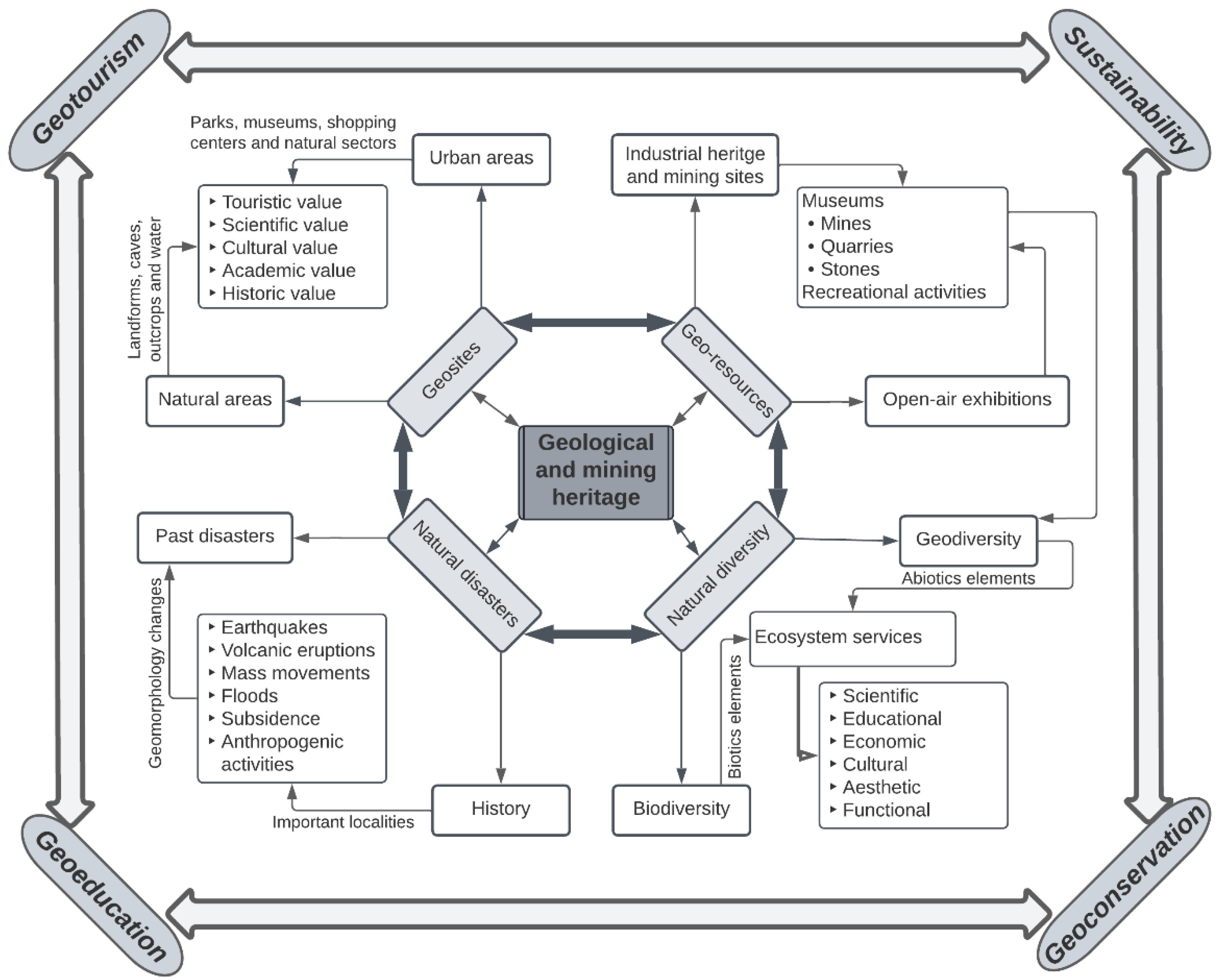
:1. Introduction
2. Materials and Methods
2.1. Methodological Approach
2.1.1. Historical Milestones and Geodiversity
2.1.2. Survey and Data Tabulation
- Sizing the level of knowledge of each interviewee;
- Identifying the most outstanding tourist areas of Guayaquil;
- Identifying the level of satisfaction and motivation of the visits;
- Identifying the interest in promoting geotourism in the evaluated geosites;
- Identifying the most outstanding issues to improve the degree of citizen satisfaction.
2.1.3. Perception Analysis and Strategy Development
3. Results
3.1. History and Geodiversity of Guayaquil
3.2. Perception of Mining Geological Heritage
3.2.1. Demography
3.2.2. Distribution of Variables of the Perception Model
3.2.3. Perception of the Respondents
3.2.4. Geological-Mining Heritage Perception Model
3.2.5. Validation of the Perception Model
3.3. Strengths, Weaknesses, Opportunities, and Threats (SWOT) Analysis Plus
- Promote geosites as suitable and heritage sectors with abundant geodiversity, landscape areas, recreational areas, and natural infrastructures optimal for increasing tourism and promoting the local security of the place.
- Inculcate and engage local communities in sustainable management of geosites, preserving natural resources and geo-biodiversity of national and international tourist relevance.
- Propose information and security centres to increase geoeducation, disseminate geosite information and improve the city’s local security protocol regulation.
- Creation of projects, programs, or activities that encourage the support of government entities to promote geoconservation and economic growth and increase sales and services in the sector through geotourism.
- Encourage alliances in the geoscience area with academic entities to promote the study of natural resources, evidenced impacts and generation of multidisciplinary projects to obtain international support for the preservation and improvement of the geosystem.
- Develop workshops with communities, government entities, and local authorities of the sector to improve the management of geosites and avoid conflicts of interest, which harm the generation of future projects and adequate planning.
4. Discussion
4.1. Geoscientific and Historical Literature of Guayaquil City
4.2. Perception of Geological and Mining Heritage
4.3. Approach of Strategies for the Geoconservation of Heritage
- Promoting the heritage value of the sector;
- Encouraging geo-education and the dissemination of information;
- Increasing geotourism and local security;
- Encouraging support from authorities and academic institutions;
- National and international recognition through geotourism and geoconservation of geosites.
5. Conclusions
- Promotion or dissemination of geosites and their heritage value;
- Inculcate sustainable management at the urban, national and international levels;
- Strategic location of geosite information and security centres;
- Encourage the creation of projects or programs that link nature with the city;
- Promote geoscientific alliances to improve the study of natural resources and sustainability;
- Develop workshops as part of a geo-educational program to improve the recognition of natural spaces and reduce conflicts of interest;
- Propose strategies to promote geoeducation in educational centres at all levels for the knowledge of their geoheritage and its conservation.
Supplementary Materials
Author Contributions
Funding
Data Availability Statement
Acknowledgments
Conflicts of Interest
References
- Gonzalez, V.M.; Coromina, L.; Galí, N. Overtourism: Residents’ Perceptions of Tourism Impact as an Indicator of Resident Social Carrying Capacity-Case Study of a Spanish Heritage Town. Tour. Rev. 2018, 73, 277–296. [Google Scholar] [CrossRef]
- Poria, Y.; Reichel, A.; Biran, A. Heritage Site Perceptions and Motivations to Visit. J. Travel Res. 2006, 44, 318–326. [Google Scholar] [CrossRef]
- Korani, Z.; Sam, F. A Comparative Study of Heritage Visitors’ Perceptions of Time in the Modern Era. Curr. Issues Tour. 2022, 1–16. [Google Scholar] [CrossRef]
- Nair, P.; Singh, D.P.; Munoth, N. “Heritage Village” Designation Impact on the Village: A Case Study on the Perception of the Residents of Kalpathy Village (Kerala). J. Inst. Eng. Ser. A 2022, 103, 493–500. [Google Scholar] [CrossRef]
- de Oliveira, R.A.; Baracho, R.M.A.; Cantoni, L. The Perception of UNESCO World Heritage Sites’ Managers about Concepts and Elements of Cultural Sustainability in Tourism. J. Cult. Herit. Manag. Sustain. Dev. 2022. [Google Scholar] [CrossRef]
- Kibria, M.M.; Dilshad, T.; Al Asek, A. Policy Implications Based on Stakeholders’ Perceptions for Integrated Management of the Halda River: Bangabandhu Fisheries Heritage of Bangladesh. Water Policy 2022, 24, 517–533. [Google Scholar] [CrossRef]
- Herrera-Franco, G.; Carrión-Mero, P.; Aguilar-Aguilar, M.; Morante-Carballo, F.; Jaya-Montalvo, M.; Morillo-Balsera, M.C. Groundwater Resilience Assessment in a Communal Coastal Aquifer System. The Case of Manglaralto in Santa Elena, Ecuador. Sustainability 2020, 12, 8290. [Google Scholar] [CrossRef]
- Reynard, E.; Brilha, J. (Eds.) Geoheritage: Assessment, Protection and Management; Elsevier: Amsterdam, The Netherlands, 2018; 450p, ISBN 978-0-12-809531-7. [Google Scholar]
- Briones-Bitar, J.; Carrión-Mero, P.; Herrera-Franco, G. Management Practices for a Sustainable Community and Its Impact on Development, Manglaralto-Santa Elena, Ecuador. In Proceedings of the 17th LACCEI International Multi-Conference for Engineering, Education, and Technology: “Industry, Innovation, and Infrastructure for Sustainable Cities and Communities”, Montego Bay, Jamaica, 24–26 July 2019. [Google Scholar]
- Gray, M. Geodiversity, Geoheritage and Geoconservation for Society. Int. J. Geoheritage Park. 2019, 7, 226–236. [Google Scholar] [CrossRef]
- Lazzari, M.; Aloia, A. Geoparks, Geoheritage and Geotourism: Opportunities and Tools in Sustainable Development of the Territory. Geoj. Tour. Geosites 2014, 13, 8–9. [Google Scholar]
- Panizza, M. Outstanding Intrinsic and Extrinsic Values of the Geological Heritage of the Dolomites (Italy). Geoheritage 2018, 10, 607–612. [Google Scholar] [CrossRef]
- Muda, J. The Geological Heritage Values and Potential Geotourism Development of the Beaches in Northern Sabah, Malaysia. Bull. Geol. Soc. Malays. 2013, 59, 1–7. [Google Scholar]
- Szepesi, J.; Ésik, Z.; Soós, I.; Németh, B.; Sütő, L.; Novák, T.J.; Harangi, S.; Lukács, R. Identification of Geoheritage Elements in a Cultural Landscape: A Case Study from Tokaj Mts, Hungary. Geoheritage 2020, 12, 89. [Google Scholar] [CrossRef]
- Alexandrowicz, Z.; Urban, J.; Miśkiewicz, K. Geological Values of Selected Polish Properties of the UNESCO World Heritage List. Geoheritage 2009, 1, 43–52. [Google Scholar] [CrossRef]
- Morante-Carballo, F.; Herrera-Narváez, G.; Jiménez-Orellana, N.; Carrión-Mero, P. Puyango, Ecuador Petrified Forest, a Geological Heritage of the Cretaceous Albian-Middle, and Its Relevance for the Sustainable Development of Geotourism. Sustainability 2020, 12, 6579. [Google Scholar] [CrossRef]
- Pasquaré Mariotto, F.; Bonali, F.L.; Venturini, C. Iceland, an Open-Air Museum for Geoheritage and Earth Science Communication Purposes. Resources 2020, 9, 14. [Google Scholar] [CrossRef]
- Palladino, G.; Prosser, G.; Bentivenga, M. The Geological Itinerary of Sasso Di Castalda: A Journey into the Geological History of the Southern Apennine Thrust-Belt (Basilicata, Southern Italy). Geoheritage 2013, 5, 47–58. [Google Scholar] [CrossRef]
- Almeida, D.G.; Lacaba, R.G.; Torrens, R.B. La Conservación del Patrimonio Geológico y Minero como Medio para Alcanzar el Desarrollo Sostenible. Minería y Geol. 2003, 19, 121–128. [Google Scholar]
- Bonomo, A.E.; Acito, A.M.; Prosser, G.; Rizzo, G.; Munnecke, A.; Koch, R.; Bentivenga, M. Matera’s Old Quarries: Geological and Historical Archives That Need Protection and Valorization. Geoheritage 2019, 11, 1603–1619. [Google Scholar] [CrossRef]
- Brilha, J.; Gray, M.; Pereira, D.I.; Pereira, P. Geodiversity: An Integrative Review as a Contribution to the Sustainable Management of the Whole of Nature. Environ. Sci. Policy 2018, 86, 19–28. [Google Scholar]
- Lazzari, M. Geosites, Cultural Tourism and Sustainability in the Gargano National Park (Southern Italy): The Case Study of the La Salata (Vieste) Geoarchaeological Site. In Proceedings of the 12th European Geopark Conference, Cilento, Italy, 4–6 September 2013; Volume 28, pp. 97–101. [Google Scholar]
- Carrión-Mero, P.; Ayala-Granda, A.; Serrano-Ayala, S.; Morante-Carballo, F.; Aguilar-Aguilar, M.; Gurumendi-Noriega, M.; Paz-Salas, N.; Herrera-Franco, G.; Berrezueta, E. Assessment of Geomorphosites for Geotourism in the Northern Part of the “Ruta Escondida” (Quito, Ecuador). Sustainability 2020, 12, 8468. [Google Scholar] [CrossRef]
- Pijet-Migoń, E.; Migoń, P. Geoheritage and Cultural Heritage—A Review of Recurrent and Interlinked Themes. Geosciences 2022, 12, 98. [Google Scholar] [CrossRef]
- Pásková, M.; Zelenka, J.; Ogasawara, T.; Zavala, B.; Astete, I. The ABC Concept—Value Added to the Earth Heritage Interpretation? Geoheritage 2021, 13, 38. [Google Scholar] [CrossRef]
- Carrión-Mero, P.; Montalván-Burbano, N.; Herrera-Narváez, G.; Morante-Carballo, F. Geodiversity and Mining Towards the Development of Geotourism: A Global Perspective. Int. J. Des. Nat. Ecodynamics 2021, 16, 191–201. [Google Scholar] [CrossRef]
- Ferrero, E.; Giardino, M.; Lozar, F.; Giordano, E.; Belluso, E.; Perotti, L. Geodiversity Action Plans for the Enhancement of Geoheritage in the Piemonte Region (North-Western Italy). Ann. Geophys. 2012, 55, 3. [Google Scholar]
- Erikstad, L. Geoheritage and Geodiversity Management—The Questions for Tomorrow. Proc. Geol. Assoc. 2013, 124, 713–719. [Google Scholar] [CrossRef]
- Finzi, Y.; Avni, S.; Maroz, A.; Avriel-Avni, N.; Ashckenazi-Polivoda, S.; Ryvkin, I. Extraordinary Geodiversity and Geoheritage Value of Erosional Craters of the Negev Craterland. Geoheritage 2019, 11, 875–896. [Google Scholar] [CrossRef]
- da Silva, P.; Gomes, R.; Mansur, K.L.; de Souza Ferreira de Castro, A. Consolidação Da Geodiversidade como Patrimônio e o Valor Geológico dos Monumentos do Rio de Janeiro. Anu. do Inst. Geocienc. 2020, 43, 488–497. [Google Scholar] [CrossRef]
- Palacio-Prieto, J.L. Geoheritage within Cities: Urban Geosites in Mexico City. Geoheritage 2015, 7, 365–373. [Google Scholar] [CrossRef]
- Corbí, H.; Martínez-Martínez, J.; Martin-Rojas, I. Linking Geological and Architectural Heritage in a Singular Geosite: Nueva Tabarca Island (SE Spain). Geoheritage 2019, 11, 703–716. [Google Scholar] [CrossRef]
- Reverte, F.C.; Garcia, M.G.M. The Geological Heritage of São Sebastião, SP: Inventory and Potential Use of Geosites with Scientific Value | O Patrimônio Geológico de São Sebastião—Sp: Inventário e Uso Potencial de Geossítios Com Valor Científico. Geociencias 2016, 35, 495–511. [Google Scholar]
- Pilogallo, A.; Nolè, G.; Amato, F.; Saganeiti, L.; Bentivenga, M.; Palladino, G.; Scorza, F.; Murgante, B.; Las Casas, G. Geotourism as a Specialization in the Territorial Context of the Basilicata Region (Southern Italy). Geoheritage 2019, 11, 1435–1445. [Google Scholar] [CrossRef]
- Brilha, J. Geoconservation and Protected Areas. Environ. Conserv. 2002, 29, 273–276. [Google Scholar]
- Dowling, R.; Newsome, D. Geotourism: The Tourism of Geology and Landscape; Goodfellow Publishers Ltd.: Oxford, UK, 2010. [Google Scholar]
- Hose, T.A. Selling the Story of Britain’s Stone. Environ. Interpret. 1995, 10, 16–17. [Google Scholar]
- Bruschi, V.M.; Cendrero, A. Geosite Evaluation; Can We Measure Intangible Values? J. Quat. Sci. 2005, 18, 293–306. [Google Scholar]
- Francesco, G.; Mario, B.; Giuseppe, P. Environmental Geology Applied to Geoconservation in the Interaction Between Geosites and Linear Infrastructures in South-Eastern Italy. Geoheritage 2015, 7, 33–46. [Google Scholar] [CrossRef]
- Wimbledon, W.A.P.; Smith-Meyer, S. Geoheritage in Europe and Its Conservation; ProGEO Oslo: Uppsala, Sweden, 2012; Volume 405. [Google Scholar]
- Kubalíková, L.; Bajer, A.; Balková, M. Brief Notes on Geodiversity and Geoheritage Perception by the Lay Public. Geosciences 2021, 11, 54. [Google Scholar]
- Chrobak, A.; Ugolini, F.; Pearlmutter, D.; Raschi, A. Thermal Tourism and Geoheritage: Examining Visitor Motivations and Perceptions. Resources 2020, 9, 58. [Google Scholar]
- UNESCO World Heritage List. Available online: https://whc.unesco.org/en/list/ (accessed on 27 April 2022).
- UNESCO List of UNESCO Global Geoparks (UGGp). Available online: https://www.unesco.org/en/articles/unesco-designates-8-new-global-geoparks (accessed on 27 April 2022).
- Torabi Farsani, N.; Coelho, C.; Costa, C. Geotourism and Geoparks as Gateways to Socio-Cultural Sustainability in Qeshm Rural Areas, Iran. Asia Pac. J. Tour. Res. 2012, 17, 30–48. [Google Scholar] [CrossRef]
- Herrera Franco, G.; Carrion Mero, P.; Morante Carballo, F.; Herrera Narváez, G.; Briones Bitar, J.; Blanco Torrens, R. Strategies for the Development of the Value of the Mining-Industrial Heritage of the Zaruma-Portovelo, Ecuador, in the Context of a Geopark Project. Int. J. Energy Prod. Manag. 2020, 5, 48–59. [Google Scholar] [CrossRef]
- Rosado-González, E.M.; Sá, A.A.; Palacio-Prieto, J.L. UNESCO Global Geoparks in Latin America and the Caribbean, and Their Contribution to Agenda 2030 Sustainable Development Goals. Geoheritage 2020, 12, 36. [Google Scholar] [CrossRef]
- Bentivenga, M.; Cavalcante, F.; Mastronuzzi, G.; Palladino, G.; Prosser, G. Geoheritage: The Foundation for Sustainable Geotourism. Geoheritage 2019, 11, 1367–1369. [Google Scholar] [CrossRef] [Green Version]
- Hose, T.A. Geoheritage and Geotourism: A European Perspective; Boydell & Brewer: Woodbridge, UK, 2016; Volume 19, ISBN 1783271477. [Google Scholar]
- Wang, L.; Tian, M.; Wang, L. Geodiversity, Geoconservation and Geotourism in Hong Kong Global Geopark of China. Proc. Geol. Assoc. 2015, 126, 426–437. [Google Scholar] [CrossRef]
- UNESCO Hong Kong Geopark’s Top Attractions. Available online: https://www.geopark.gov.hk/en (accessed on 23 April 2022).
- Guo, W.; Chung, S. Using Tourism Carrying Capacity to Strengthen UNESCO Global Geopark Management in Hong Kong. Geoheritage 2019, 11, 193–205. [Google Scholar] [CrossRef]
- Fung, C.K.W.; Jim, C.Y. Segmentation by Motivation of Hong Kong Global Geopark Visitors in Relation to Sustainable Nature-Based Tourism. Int. J. Sustain. Dev. World Ecol. 2015, 22, 76–88. [Google Scholar]
- Pasquaré Mariotto, F.; Venturini, C. Strategies and Tools for Improving Earth Science Education and Popularization in Museums. Geoheritage 2017, 9, 187–194. [Google Scholar] [CrossRef]
- Venturini, C.; Pasquaré Mariotto, F. Geoheritage Promotion Through an Interactive Exhibition: A Case Study from the Carnic Alps, NE Italy. Geoheritage 2019, 11, 459–469. [Google Scholar] [CrossRef]
- Morante-Carballo, F.; Merchán-Sanmartín, B.; Cárdenas-Cruz, A.; Jaya-Montalvo, M.; Mata-Perelló, J.; Herrera-Franco, G.; Carrión-Mero, P. Sites of Geological Interest Assessment for Geoeducation Strategies, ESPOL University Campus, Guayaquil, Ecuador. Land 2022, 11, 771. [Google Scholar] [CrossRef]
- Carrión-Mero, P.; Morante-Carballo, F.; Herrera-Franco, G.; Maldonado-Zamora, A.; Paz-Salas, N. The Context of Ecuador’s World Heritage, for Sustainable Development Strategies. Int. J. Des. Nat. Ecodynamics 2020, 15, 39–46. [Google Scholar] [CrossRef]
- UNESCO Protect Our Natural and Cultural Heritage. Available online: https://whc.unesco.org/ (accessed on 26 April 2022).
- UNESCO UNESCO World Network of Biosphere Reserves. Available online: https://en.unesco.org/news/18-new-sites-join-unescos-world-network-biosphere-reserves (accessed on 27 March 2022).
- UNESCO Imbabura UNESCO Global Geopark Ecuador. Available online: https://en.unesco.org/galleries/imbabura-unesco-global-geopark-ecuador (accessed on 28 April 2022).
- Berrezueta, E.; Sánchez-Cortez, J.L.; Aguilar-Aguilar, M. Inventory and Characterization of Geosites in Ecuador: A Review. Geoheritage 2021, 13, 93. [Google Scholar] [CrossRef]
- Vázquez Taset, Y.M. Imbabura: The First UNESCO Geopark in Ecuador. Bionatura 2019, 4, 830–831. [Google Scholar] [CrossRef]
- González, Á.R.P.; Palacios, J.C.A.; Quelal, L.R.C. Marketing y Turismo Sostenible en el Geoparque Imbabura, Ecuador. ECA Sinerg. 2021, 12, 97. [Google Scholar] [CrossRef]
- Carrión-Mero, P.; Dueñas-Tovar, J.; Jaya-Montalvo, M.; Berrezueta, E.; Jiménez-Orellana, N. Geodiversity Assessment to Regional Scale: Ecuador as a Case Study. Environ. Sci. Policy 2022, 136, 167–186. [Google Scholar] [CrossRef]
- Reynaud, J.-Y.; Witt, C.; Pazmiño, A.; Gilces, S. Tide-Dominated Deltas in Active Margin Basins: Insights from the Guayas Estuary, Gulf of Guayaquil, Ecuador. Mar. Geol. 2018, 403, 165–178. [Google Scholar] [CrossRef]
- Orden-Mejía, M.; Carvache-Franco, M.; Huertas, A.; Carvache-Franco, W.; Landeta-Bejarano, N.; Carvache-Franco, O. Post-COVID-19 Tourists’ Preferences, Attitudes and Travel Expectations: A Study in Guayaquil, Ecuador. Int. J. Environ. Res. Public Health 2022, 19, 4822. [Google Scholar] [CrossRef]
- Brunett, A.L.L.; Masache, E.V.; Brunett, A.H.L. Turismo 2.0 como Herramienta para Promocionar los Atractivos Culturales de Guayaquil. INNOVA Res. J. 2017, 2, 154–163. [Google Scholar] [CrossRef]
- Barreth, A.C.; Sang, Y.F.; Quiroga, S.T. Tourist Bus Maps as Contribution to Tourist Movements in Guayaquil. J. Tour. Herit. Res. 2020, 3, 452–477. [Google Scholar]
- Fun Sang Vera, Y.M. Análisis de la Conectividad entre el Transporte Público y los Atractivos Turísticos de Guayaquil para una Propuesta de Mapa Turístico de Buses. Bachelor’s Thesis, Universidad de Guayaquil, Guayaquil, Ecuador, 2018. [Google Scholar]
- Carrión-Mero, P.; Morante-Carballo, F.; Apolo-Masache, B. Evaluation of Geosites as an Alternative for Geotouristic Development in Guayaquil, Ecuador. WIT Trans. Ecol. Environ. 2020, 241, 45–56. [Google Scholar]
- Pijet-Migoń, E.; Migoń, P. Linking Wine Culture and Geoheritage—Missing Opportunities at European UNESCO World Heritage Sites and in UNESCO Global Geoparks? A Survey of Web-Based Resources. Geoheritage 2021, 13, 71. [Google Scholar] [CrossRef]
- Bazsik, I.; Bujdosó, Z.; Koncz, G. Interrelations between Wine Tourism and Geotourism: A Wine Consumption Survey in Monor (Hungary). Geoj. Tour. Geosites 2021, 39, 1517–1524. [Google Scholar] [CrossRef]
- Gravis, I.; Németh, K.; Procter, J.N. The Role of Cultural and Indigenous Values in Geosite Evaluations on a Quaternary Monogenetic Volcanic Landscape at Ihumātao, Auckland Volcanic Field, New Zealand. Geoheritage 2017, 9, 373–393. [Google Scholar] [CrossRef]
- Ek Styvén, M.; Näppä, A.; Mariani, M.; Nataraajan, R. Employee Perceptions of Employers’ Creativity and Innovation: Implications for Employer Attractiveness and Branding in Tourism and Hospitality. J. Bus. Res. 2022, 141, 290–298. [Google Scholar] [CrossRef]
- Robinson, D.; Newman, S.P.; Stead, S.M. Community Perceptions Link Environmental Decline to Reduced Support for Tourism Development in Small Island States: A Case Study in the Turks and Caicos Islands. Mar. Policy 2019, 108, 103671. [Google Scholar] [CrossRef]
- IGM. Capas de Información Geográfica Básica Del IGM de Libre Acceso. Cartas Topográficas Escala 1:50.000, Formato Shp. Available online: http://www.geoportaligm.gob.ec/portal/index.php/cartografia-de-libre-acceso-escala-50k/ (accessed on 24 July 2022).
- Herrera-Franco, G.; Carrión-Mero, P.; Alvarado, N.; Morante-Carballo, F.; Maldonado, A.; Caldevilla, P.; Briones-Bitar, J.; Berrezueta, E. Geosites and Georesources to Foster Geotourism in Communities: Case Study of the Santa Elena Peninsula Geopark Project in Ecuador. Sustainability 2020, 12, 4484. [Google Scholar] [CrossRef]
- Alcaraz-Quiles, F.J.; Navarro-Galera, A.; Ortiz-Rodríguez, D. Factors Determining Online Sustainability Reporting by Local Governments. Int. Rev. Adm. Sci. 2014, 81, 79–109. [Google Scholar] [CrossRef]
- Murray, R.; Larry, J. Estadística, 4th ed.; Mc Grawill: New York, NY, USA, 2009. [Google Scholar]
- INEC. Proyecciones Poblacionales Cantonales. Available online: https://www.ecuadorencifras.gob.ec/inec-presenta-sus-proyecciones-poblacionales-cantonales/#:~:text=Según estos datos%2C Quito en,El Oro con 2.379 habitantes (accessed on 15 May 2021).
- Gigante, F.D.; Santos, J.P.V.; López-Bao, J.V.; Olea, P.P.; Verschuuren, B.; Mateo-Tomás, P. Farmers’ Perceptions towards Scavengers Are Influenced by Implementation Deficits of EU Sanitary Policies. Biol. Conserv. 2021, 259, 109166. [Google Scholar] [CrossRef]
- Bhuiyan, M.A.H.; Darda, M.A.; Hasan, M.R. Tourist Perception and Satisfaction on Safari Tourism at Bangabandhu Sheikh Mujib Safari Park in Bangladesh. Int. J. Geoheritage Park. 2021, 9, 430–440. [Google Scholar] [CrossRef]
- Kiruthiga, K.; Thirumaran, K. Visual Perception on the Architectural Elements of the Built Heritage of a Historic Temple Town: A Case Study of Kumbakonam, India. Front. Archit. Res. 2017, 6, 96–107. [Google Scholar] [CrossRef]
- Jaafar, M.; Noor, S.M.; Rasoolimanesh, S.M. Perception of Young Local Residents toward Sustainable Conservation Programmes: A Case Study of the Lenggong World Cultural Heritage Site. Tour. Manag. 2015, 48, 154–163. [Google Scholar] [CrossRef]
- Zhao, S.; Timothy, D.J. Tourists’ Consumption and Perceptions of Red Heritage. Ann. Tour. Res. 2017, 63, 97–111. [Google Scholar] [CrossRef]
- Wang, J.; Wang, Z. Strengths, Weaknesses, Opportunities and Threats (SWOT) Analysis of China’s Prevention and Control Strategy for the COVID-19 Epidemic. Int. J. Environ. Res. Public Health 2020, 17, 2235. [Google Scholar] [CrossRef]
- Jiang, R.; Mao, C.; Hou, L.; Wu, C.; Tan, J. A SWOT Analysis for Promoting Off-Site Construction under the Backdrop of China’s New Urbanisation. J. Clean. Prod. 2018, 173, 225–234. [Google Scholar] [CrossRef]
- Sztando, A. Analiza Strategiczna Jednostek Samorządu Terytorialnego [Strategic Analysis of the Local Governments]. In Metody Oceny Rozwoju Regionalnego; Akademia Ekonomiczna we Wrocławiu: Wrocław, Poland, 2006. [Google Scholar]
- Gierszewska, G.; Olszewska, B.; Skonieczny, J. Zarządzanie Strategiczne Dla Inżynierów; Polskie Wydawnictwo Ekonomiczne: Warszawa, Poland, 2013; ISBN 8320820510. [Google Scholar]
- Nazarko, J.; Ejdys, J.; Halicka, K.; Magruk, A.; Nazarko, Ł.; Skorek, A. Application of Enhanced SWOT Analysis in the Future-Oriented Public Management of Technology. Procedia Eng. 2017, 182, 482–490. [Google Scholar] [CrossRef]
- Municipio de Guayaquil. Guayaquil es mi Destino. Available online: https://www.guayaquilesmidestino.com/sites/default/files/gastronomica2.pdf (accessed on 21 September 2021).
- GeoRaymi. Fundación de Guayaquil. Available online: https://www.goraymi.com/es-ec/guayas/guayaquil/fundaciones/fundacion-guayaquil-agg38ze7p (accessed on 24 July 2022).
- Silva Guijarro, V.H. Los Hijos del Guayas en Busca de la Libertad. Análisis Historiográfico sobre el Protagonismo Socio-Étnico en la Independencia de Guayaquil según los Textos Escolares de Historia (1915–2015). Hist. Const. 2021, 22, 195–215. [Google Scholar] [CrossRef]
- Laviana Cuetos, M.L. Guayaquil en el Siglo XVIII: Recursos Naturales y Desarrollo Económico; Editorial CSIC-CSIC Press: Madrid, Spain, 2002. [Google Scholar]
- Calle, J.; Reinoso, J.; Michalon, R.; Aviles, J.C. Recopilacion de Informacion Base para el Mapa Geoambiental del Area Urbana del Gran Guayaquil y Mapas en Formato SIG. Bachelor’s Thesis, Superior Politécnica del Litoral, Guayaquil, Ecuador, 2005; pp. 132–153. [Google Scholar]
- Menendez-Carbo, S.; Ruano, M.A.; Zambrano-Monserrate, M.A. The Economic Value of Malecón 2000 in Guayaquil, Ecuador: An Application of the Travel Cost Method. Tour. Manag. Perspect. 2020, 36, 100727. [Google Scholar] [CrossRef]
- Ortíz González, A. Procedencia de las Rocas Sedimentarias de los Cerros Santa Ana y del Carmen mediante Análisis Geoquímico, Guayaquil-Ecuador. Bachelor’s Thesis, Universidad de Guayaquil, Guayaquil, Ecuador, 2019. [Google Scholar]
- Guadalupe, D.; Caicedo, S.; Jorge, L.; Murillo, R. Diseño de un Plan Piloto Turístico Educativo sobre el Cementerio Patrimonial de Guayaquil Dirigido a los Estudiantes de la Escuela Dr. Alberto Avellán Vite. Ph.D. Thesis, Universidad de Guayaquil, Guayaquil, Ecuador, 2017. [Google Scholar]
- Morante-Carballo, F.; Aguilar-Aguilar, M.; Ramírez, G.; Blanco, R.; Carrión-Mero, P.; Briones-Bitar, J.; Berrezueta, E. Evaluation of Slope Stability Considering the Preservation of the General Patrimonial Cemetery of Guayaquil, Ecuador. Geosciences 2019, 9, 103. [Google Scholar] [CrossRef]
- Ministerio del Ambiente Ecuatoriano. Refugio de Vida Silvestre Manglares El Morro | Sistema Nacional de Áreas Protegidas del Ecuador. Available online: http://areasprotegidas.ambiente.gob.ec/es/areas-protegidas/refugio-de-vida-silvestre-manglares-el-morro (accessed on 21 March 2022).
- Machiels, L.; Garcés, D.; Snellings, R.; Vilema, W.; Morante-Carballo, F.; Paredes, C.; Elsen, J. Zeolite Occurrence and Genesis in the Late-Cretaceous Cayo Arc of Coastal Ecuador: Evidence for Zeolite Formation in Cooling Marine Pyroclastic Flow Deposits. Appl. Clay Sci. 2014, 87, 108–119. [Google Scholar] [CrossRef]
- Borde, A. Plan Maestro Bosque Protector Cerro Blanco. Guayaquil, Ecuador, 2021. ARQ 2021, 108, 90–99. [Google Scholar] [CrossRef]
- Horstman, E. Establishing a Private Protected Area in Ecuador: Lessons Learned in the Management of Cerro Blanco Protected Forest in the City of Guayaquil. Case Stud. Environ. 2017, 1, 1–14. [Google Scholar] [CrossRef]
- Cruz Cordovez, C.; Herrera, I.; Espinoza, F.; Rizzo, K. New Record of a Feral Population of Lithobates Catesbeianus Shaw, 1802 in a Protected Area (Santay Island) in the Ecuadorian Coast. BioInvasions Rec. 2020, 9, 421–433. [Google Scholar] [CrossRef]
- Diaz-Christiansen, S.; López-Guzmán, T.; Pérez Gálvez, J.C.; Muñoz Fernández, G.A. Wetland Tourism in Natural Protected Areas: Santay Island (Ecuador). Tour. Manag. Perspect. 2016, 20, 47–54. [Google Scholar] [CrossRef]
- Wu, T.-C.; Xie, P.F.; Tsai, M.-C. Perceptions of Attractiveness for Salt Heritage Tourism: A Tourist Perspective. Tour. Manag. 2015, 51, 201–209. [Google Scholar] [CrossRef]
- Outeiro, L.; Villasante, S.; Oyarzo, H. The Interplay between Fish Farming and Nature Based Recreation-Tourism in Southern Chile: A Perception Approach. Ecosyst. Serv. 2018, 32, 90–100. [Google Scholar] [CrossRef]
- Hair, J.F.; Ringle, C.M.; Sarstedt, M. PLS-SEM: Indeed a Silver Bullet. J. Mark. Theory Pract. 2011, 19, 139–152. [Google Scholar] [CrossRef]
- Kubalíková, L.; Kirchner, K.; Bajer, A. Secondary Geodiversity and Its Potential for Urban Geotourism: A Case Study from Brno City, Czech Republic. Quaest. Geogr. 2017, 36, 63–73. [Google Scholar] [CrossRef] [Green Version]
- Dos Polck, M.A.R.; de Medeiros, M.A.M.; de Araújo-Júnior, H.I. Geodiversity in Urban Cultural Spaces of Rio de Janeiro City: Revealing the Geoscientific Knowledge with Emphasis on the Fossil Content. Geoheritage 2020, 12, 47. [Google Scholar] [CrossRef]
- Pereira, L.S.; da Silva Farias, T. Assessing the Cultural Values of the Geodiversity in a Brazilian City: The Historical Center of João Pessoa (Paraíba, NE Brazil), Mata Da Aldeia Chart. Int. J. Geoheritage Park. 2020, 8, 59–73. [Google Scholar] [CrossRef]
- Cañizares, A.D.; Bourotte, C.L.M.; Garcia, M.d.G.M. Estudo Exploratório sobre a Percepção Da Geodiversidade e Das Geociências Pela População Da Região Metropolitana de São Paulo. Anuário do Inst. Geociências 2019, 42, 375–386. [Google Scholar] [CrossRef]
- Russ, B.R.; Csek, M. Revealing Geodiversity Trough Environmental Education: Perceptions of Students about the Manga Do Céu Geosite. Anuário do Inst. Geociências 2012, 35, 271–280. [Google Scholar] [CrossRef]
- Ervural, B.C.; Zaim, S.; Demirel, O.F.; Aydin, Z.; Delen, D. An ANP and Fuzzy TOPSIS-Based SWOT Analysis for Turkey’s Energy Planning. Renew. Sustain. Energy Rev. 2018, 82, 1538–1550. [Google Scholar] [CrossRef]
- Markovska, N.; Taseska, V.; Pop-Jordanov, J. SWOT Analyses of the National Energy Sector for Sustainable Energy Development. Energy 2009, 34, 752–756. [Google Scholar] [CrossRef]
- Laviana Cuetos, M.L. Una Descripción Inédita de Guayaquil. Temas Am. 1982, 1, 73–84. [Google Scholar]
- Valle Reyes, A.S. Diseño de una Ruta Turistica Colonial “Encantos del Cerrito Verde” como Medio de Interpretacion del Patrimonio Cultural en el Cerro Santa Ana de La Ciudad de Guayaquil Provincia del Guayas. Bachelor’s Thesis, Universidad de Guayaquil, Guayaquil, Ecuador, 2014. [Google Scholar]
- El Telégrafo. Los Manglares Restauran Suelos Hasta en el 89%. Available online: https://www.eltelegrafo.com.ec/noticias/guayaquil/1/manglares-suelos-guayaquil-estero-salado (accessed on 21 February 2022).
- Mariscal-Santi, W.E.; Garcia-Larreta, F.S.; Mariscal-Garcia, R.S.; Cornejo-Ortega, A.V.; Ortega-Ramirez, P.M.; Montiel-Rivera, T.A.; Ponce-Solórzano, H.X.; De La Torre-Quinonez, E.F. Evaluación de la Contaminación Físico-Química de las Aguas Del Estero Salado, Sector Norte de la Ciudad de Guayaquil-Ecuador-2017. Polo del Conoc. 2018, 3, 133. [Google Scholar] [CrossRef]
- Beigi, H.; Pakzad, P. Investigating Geotourism Capabilities of the Gavkhoni Wetland According to the SWOT Model. WIT Trans. Ecol. Environ. 2010, 139, 169–179. [Google Scholar]
- Datta, K. Application of SWOT-TOWS Matrix and Analytical Hierarchy Process (AHP) in the Formulation of Geoconservation and Geotourism Development Strategies for Mama Bhagne Pahar: An Important Geomorphosite in West Bengal, India. Geoheritage 2020, 12, 45. [Google Scholar] [CrossRef]
- Vardopoulos, I.; Tsilika, E.; Sarantakou, E.; Zorpas, A.; Salvati, L.; Tsartas, P. An Integrated SWOT-PESTLE-AHP Model Assessing Sustainability in Adaptive Reuse Projects. Appl. Sci. 2021, 11, 7134. [Google Scholar] [CrossRef]
- Gkoltsiou, A.; Paraskevopoulou, A. Landscape Character Assessment, Perception Surveys of Stakeholders and SWOT Analysis: A Holistic Approach to Historical Public Park Management. J. Outdoor Recreat. Tour. 2021, 35, 100418. [Google Scholar] [CrossRef]
- Savari, M.; Amghani, M.S. SWOT-FAHP-TOWS Analysis for Adaptation Strategies Development among Small-Scale Farmers in Drought Conditions. Int. J. Disaster Risk Reduct. 2022, 67, 102695. [Google Scholar] [CrossRef]
- Jiskani, I.M.; Shah, S.A.A.; Qingxiang, C.; Zhou, W.; Lu, X. A Multi-Criteria Based SWOT Analysis of Sustainable Planning for Mining and Mineral Industry in Pakistan. Arab. J. Geosci. 2020, 13, 1108. [Google Scholar] [CrossRef]
- Panigrahi, J.K.; Mohanty, P.K. Effectiveness of the Indian Coastal Regulation Zones Provisions for Coastal Zone Management and Its Evaluation Using SWOT Analysis. Ocean Coast. Manag. 2012, 65, 34–50. [Google Scholar] [CrossRef]
- Navarro-Martínez, Z.M.; Crespo, C.M.; Hernández-Fernández, L.; Ferro-Azcona, H.; González-Díaz, S.P.; McLaughlin, R.J. Using SWOT Analysis to Support Biodiversity and Sustainable Tourism in Caguanes National Park, Cuba. Ocean Coast. Manag. 2020, 193, 105188. [Google Scholar] [CrossRef]
- Jędrusik, M.; Lisowski, A.; Mouketou-Tarazewicz, D.; Ropivia, M.-L.; Zagajewski, B. Touristic Development of the La Lopé National Park (Gabon) in Light of the SWOT Analysis. Misc. Geogr. 2015, 19, 5–13. [Google Scholar] [CrossRef]
- Rezagama, A.; Setyati, W.A.; Agustini, T.W.; Sunaryo; Devi, S.A.; Deswanto, E.; Budiati, I.M. Approaching SWOT Analysis to Develop Strategies of Marine-Ecotourism in Bedono Village, Sayung, Demak. IOP Conf. Ser. Earth Environ. Sci. 2021, 750, 012059. [Google Scholar] [CrossRef]
- Carrión-Mero, P.; Borja-Bernal, C.; Herrera-Franco, G.; Morante-Carballo, F.; Jaya-Montalvo, M.; Maldonado-Zamora, A.; Paz-Salas, N.; Berrezueta, E. Geosites and Geotourism in the Local Development of Communities of the Andes Mountains. A Case Study. Sustainability 2021, 13, 4624. [Google Scholar] [CrossRef]
- Liu, R.; Wang, Y.; Qian, Z. Hybrid SWOT-AHP Analysis of Strategic Decisions of Coastal Tourism: A Case Study of Shandong Peninsula Blue Economic Zone. J. Coast. Res. 2019, 94, 671. [Google Scholar] [CrossRef]
- Gkoltsiou, A.; Mougiakou, E. The Use of Islandscape Character Assessment and Participatory Spatial SWOT Analysis to the Strategic Planning and Sustainable Development of Small Islands. The Case of Gavdos. Land Use Policy 2021, 103, 105277. [Google Scholar] [CrossRef]
- Abbas, S.; Shirazi, S.A.; Qureshi, S. SWOT Analysis for Socio-Ecological Landscape Variation as a Precursor to the Management of the Mountainous Kanshi Watershed, Salt Range of Pakistan. Int. J. Sustain. Dev. World Ecol. 2018, 25, 351–361. [Google Scholar] [CrossRef]


| Sites of Interest | Historical Aspect | Relationship with Geodiversity | References |
|---|---|---|---|
| Guayas river (Ma-lecón 2000) | Main waterway or trade channel in which they arrived at the boardwalk of the current city. It began as a place of commerce until it became a tourist centre in 2000, enhancing its heritage, tourist, and commercial value. | Two islets stand out, formed by the sedimentation that occurred in the transgression and regression of seawater. In addition, the naval trips allow us to know the natural and historical environment of the river and the boardwalk. | [95,96] |
| Santa Ana hill | The leading site where the city started. It was one of the colonial bastions for the city’s defence against pirate attacks. In addition, it is one of the scenes of the deed of the independence of Guayaquil. | Rocky massif formed by shale with a high degree of fracture and sandstone intercalations. | [91,97] |
| Cerro del Carmen | It has a viewpoint and a natural beauty that enhances its tourist activity, declared the nation’s cultural heritage in 2003, preserving the history and memory of important people, including war heroes, presidents, and artists who contributed to the city’s development. | At the city’s beginning, it served as quarries to fill and urbanize the swampy areas of Guayaquil. As a result, it has silicified and fractured shale from the Guayaquil formation, which generate block slides (of various sizes), prompting the search for solutions for slope stabilization. | [91,98,99] |
| Salty estuary (Malecón del estero Salado) | It has broad ramifications throughout the city. However, several of these areas have grown demographically, and the urban area is more extensive in terms of housing. | It is an estuary influenced by the transgression and regression of the sea that overflows with a tangle of rivers, estuaries and lagoons. It has excellent landscape, aesthetic, and recreational value. It is a unique natural ecosystem, home to diverse flora and fauna, such as mangroves settled on delta-type soils. | [94,100] |
| Quarries | They are suitable places to promote research and development due to their potential as relevant material in different areas of industry. | The San Eduardo formation’s quarries have limestone rock to produce cement for the entire country, in addition to the zeolite quarries located in volcano-sedimentary rocks. | [101] |
| Lime kilns (Bosque protector Cerro Blanco) | The lime kilns were optimal places for tourist overnight camps and their coexistence with nature. They are in Cerro Blanco, a protected forest since 1989 and the most consolidated in the city. | It is a dry forest with abundant geo-biodiversity and endemic species threatened worldwide, in addition to its geotouristic influence without affecting the intangible natural area of the reserve. | [102,103] |
| Santay island | It is one of the islets formed in the Guayas River. It has a population that has been arriving from different places but in a controlled manner. In 2010, it was declared a RAMSAR site (type I) on the Ecuadorian coast. | Its diversity of flora and fauna entails a critical tourist and investigative interest. In addition, it is in a brackish environment where various aquatic, terrestrial, bird, and halophilic vegetation (mangrove) species meet. | [104,105] |
| Variable | Name | Description |
|---|---|---|
| Y | Heritage perception | Variable response of perception of geological-mining heritage |
| X1 | Mode_information (1 *, 2 * and 3 *) | Perception of information through news |
| X2 | Benefit_tourism (0: No and 1: Yes) | Perception of tourism benefit |
| X3 | Geodiversity (0: No and 1: Yes) | Perception of knowledge of geodiversity |
| X4 | Geology (0: No and 1: Yes) | Geology knowledge perception |
| X5 | Around the city geotourism (0: No and 1: Yes) | Perception of geotourism around Guayaquil city |
| X6 | Urban geotourism (0: No and 1: Yes) | Perception of knowledge of geotourism in the city |
| X7 | Biodiversity (0: No and 1: Yes) | Perception of visit motivation due to biodiversity |
| N° | Explanatory Variables | Mean () | Standard Deviation (SD) |
|---|---|---|---|
| X1 | Mode_information | 0.97; 0.99 and 0.93 | 0.17; 0.12 and 0.26 |
| X2 | Benefit_tourism | 0.63 and 0.97 | 0.49 and 0.16 |
| X3 | Geodiversity | 0.76 and 0.98 | 0.42 and 0.13 |
| X4 | Geology | 0.62 and 0.98 | 0.49 and 0.15 |
| X5 | Around the city geotourism | 0.87 and 0.99 | 0.34 and 0.10 |
| X6 | Urban geotourism | 0.72 and 0.97 | 0.45 and 0.15 |
| X7 | Biodiversity | 0.93 and 0.98 | 0.25 and 0.12 |
| Explanatory Variables | β Coefficients | Standard Error β | Significance Level (* p) |
|---|---|---|---|
| Intercept | 0.260 | 0.049 | |
| Benefit_tourism | 0.220 | 0.038 | * 0.000 |
| Knowledge Geo | |||
| Geology | 0.198 | 0.034 | * 0.000 |
| Urban geotourism | 0.162 | 0.029 | * 0.000 |
| Geodiversity | 0.127 | 0.022 | * 0.000 |
| Around the city geotourism | 0.040 | 0.015 | 0.007 |
| Reason for visit | |||
| Biodiversity | 0.027 | 0.010 | 0.014 |
| Mode_information | 0.015 | 0.007 | 0.021 |
| Models | Sum of Squares | * DF | * F | Significance Level (* p) |
|---|---|---|---|---|
| Regression | 7.613 | 8 | 43.73 | 0.0000 |
| Residual | 10.303 | 938 | ||
| Total | 17.916 | 946 | ||
| R2 | 0.426 | |||
| Existing Factors | |
|---|---|
| Favourable internal factors | Favourable external factors |
|
|
| Unfavourable internal factors | Unfavourable external factors |
|
|
| Potential factors | |
| Favourable internal factors | Favourable external factors |
|
|
| Unfavourable internal factors | Unfavourable external factors |
|
|
Publisher’s Note: MDPI stays neutral with regard to jurisdictional claims in published maps and institutional affiliations. |
© 2022 by the authors. Licensee MDPI, Basel, Switzerland. This article is an open access article distributed under the terms and conditions of the Creative Commons Attribution (CC BY) license (https://creativecommons.org/licenses/by/4.0/).
Share and Cite
Herrera-Franco, G.; Apolo-Masache, B.; Escandón-Panchana, P.; Jácome-Francis, K.; Morante-Carballo, F.; Mata-Perelló, J.; Carrión-Mero, P. Perception of the Geological-Mining Heritage to Promote Geotourism in Guayaquil, Ecuador. Geosciences 2022, 12, 322. https://doi.org/10.3390/geosciences12090322
Herrera-Franco G, Apolo-Masache B, Escandón-Panchana P, Jácome-Francis K, Morante-Carballo F, Mata-Perelló J, Carrión-Mero P. Perception of the Geological-Mining Heritage to Promote Geotourism in Guayaquil, Ecuador. Geosciences. 2022; 12(9):322. https://doi.org/10.3390/geosciences12090322
Chicago/Turabian StyleHerrera-Franco, Gricelda, Boris Apolo-Masache, Paulo Escandón-Panchana, Kelly Jácome-Francis, Fernando Morante-Carballo, Josep Mata-Perelló, and Paúl Carrión-Mero. 2022. "Perception of the Geological-Mining Heritage to Promote Geotourism in Guayaquil, Ecuador" Geosciences 12, no. 9: 322. https://doi.org/10.3390/geosciences12090322