

The First Rock Glacier Inventory for the Greater Caucasus


1
Antarctic Research Centre, Victoria University of Wellington, P.O. Box 600, Wellington 6140, New Zealand
2
School of Geography, Environment and Earth Sciences, Victoria University of Wellington, P.O. Box 600, Wellington 6140, New Zealand
3
School of Natural Sciences and Medicine, Ilia State University, Cholokashvili Ave 3/5, 0162 Tbilisi, Georgia
4
Department of Geography, University of Zurich, Winterthurerstrasse 190, 8057 Zurich, Switzerland
5
Department of Glaciology, Institute of Geography, Russian Academy of Sciences, 29 Staromonetniy Pereulok, 119017 Moscow, Russia
*
Author to whom correspondence should be addressed.
Geosciences 2023, 13(4), 117; https://doi.org/10.3390/geosciences13040117
Submission received: 16 February 2023
/
Revised: 21 March 2023
/
Accepted: 6 April 2023
/
Published: 13 April 2023
(This article belongs to the Special Issue Mountain Glaciers, Permafrost, and Snow)
Abstract
:Rock glaciers are an integral part of the periglacial environment. At the regional scale in the Greater Caucasus, there have been no comprehensive systematic efforts to assess the distribution of rock glaciers, although some individual parts of ranges have been mapped before. In this study we produce the first inventory of rock glaciers from the entire Greater Caucasus region—Russia, Georgia, and Azerbaijan. A remote sensing survey was conducted using Geo-Information System (GIS) and Google Earth Pro software based on high-resolution satellite imagery—SPOT, Worldview, QuickBird, and IKONOS, based on data obtained during the period 2004–2021. Sentinel-2 imagery from the year 2020 was also used as a supplementary source. The ASTER GDEM (2011) was used to determine location, elevation, and slope for all rock glaciers. Using a manual approach to digitize rock glaciers, we discovered that the mountain range contains 1461 rock glaciers with a total area of 297.8 ± 23.0 km2. Visual inspection of the morphology suggests that 1018 rock glaciers with a total area of 199.6 ± 15.9 km2 (67% of the total rock glacier area) are active, while the remaining rock glaciers appear to be relict. The average maximum altitude of all rock glaciers is found at 3152 ± 96 m above sea level (a.s.l.) while the mean and minimum altitude are 3009 ± 91 m and 2882 ± 87 m a.s.l., respectively. We find that the average minimum altitude of active rock glaciers is higher (2955 ± 98 m a.s.l.) than in relict rock glaciers (2716 ± 83 m a.s.l.). No clear difference is discernible between the surface slope of active (41.4 ± 3°) and relict (38.8 ± 4°) rock glaciers in the entire mountain region. This inventory provides a database for understanding the extent of permafrost in the Greater Caucasus and is an important basis for further research of geomorphology and palaeoglaciology in this region. The inventory will be submitted to the Global Land Ice Measurements from Space (GLIMS) database and can be used for future studies.
1. Introduction
Rock glaciers are landforms of frozen debris and supersaturated with ice. They creep downslope displaying forms of cohesive flow [1,2,3]. They are iconic features of the periglacial environment and have been investigated in the fields of geomorphology [4,5,6,7], alpine ecology [8,9], hydrology [10,11,12], natural hazard [13,14,15], and paleo-climatology [16,17,18,19,20]. Rock glaciers also serve as proxy for the spatial distribution of mountain permafrost [21,22,23] and as an indicator of its link with the climate system [24,25,26,27].
Understanding the processes controlling rock glacier dynamics at different time scales has improved due to geophysical and modelling studies [28,29,30,31,32]. At the same time, many studies have investigated their behavior at the regional scale, highlighting common global and regional patterns in their flow [27,33,34,35]. In addition, some studies have suggested that rock glaciers might be important sources of water, especially in dry and cold environments [28,36,37]. For all of these reasons, rock glacier inventories have become a priority in many countries around the globe and many studies are contributing towards the creation of regional and global databases, with thousands of rock glaciers identified and analyzed throughout entire regions [38,39,40,41,42]. Concurrently, important efforts from the rock glacier research community have been made to establish standards and guidelines for consistent mapping in order to minimize the uncertainties related to subjective decisions [43,44].
In the Greater Caucasus, rock glaciers provide hydrologic reserves and ecologic refugia with respect to ongoing and future climate changes as well as promoting vegetation communities and habitat for alpine terrestrial species [45]. Discharge of water from rock glacier springs and groundwater is a significant source of fresh water for the Caucasus countries [42]. They are specifically important reservoirs of water for the population living downstream, often providing meltwater during seasonal droughts, mainly for the eastern Greater Caucasus. Rock glaciers also play a significant role as a major tourist attraction for the economy of the Caucasus countries. For example, the prominent rock glacier in Juta River valley in the Kazbegi region, Georgia, is visited by thousands of tourists each year. Thus, the assessment of rock glaciers in the Greater Caucasus is crucial for both scientific and societal points of view.
In this study we present the first rock glacier inventory for the entire Greater Caucasus region obtained from various high-resolution satellite images (2004–2021) in combination with an ASTER digital elevation model (2011) along with various attributes (area, elevations, slope, and activity status) and location.
2. Study Area
2.1. General Characteristics
The Greater Caucasus Range, located between the Black and Caspian Seas, extends approximately 1300 km from northwest to southeast (Figure 1). The width of the Greater Caucasus varies in different parts from 32 km to 180 km. The main watershed range with its northern and southern macro-slopes represents the largest structural element of the Greater Caucasus. Due to climatic and morphological features, the Greater Caucasus is traditionally divided into three parts—western, central, and eastern sections (Figure 1). The western Greater Caucasus is the lowest part of this mountain region, starting almost from the Crimean Peninsula (Black and Azov Seas) and extends to Mt. Elbrus (5642 m a.s.l.). Mt. Dombai-Ulgen, with an elevation of 4046 m a.s.l., is the highest peak in the western Greater Caucasus. The territory between Mt. Elbrus (5642 m a.s.l.) and Mt. Kazbegi (5047 m a.s.l.) is the highest part of the range and is called the central Greater Caucasus. There are about ten mountain peaks exceeding 5000 m a.s.l. in the central Greater Caucasus. The eastern Greater Caucasus starts from the Mt. Kazbegi and reaches almost the Absheron Peninsula (Caspian Sea). It is a relatively low range with the highest peaks reaching up to 4493 m (Mt. Tebulosmta) and 4466 m a.s.l. (Mt. Bazardüzü). The altitude of the eastern section gradually decreases to the southeastern direction, ranging between 2200–3500 m a.s.l. The Greater Caucasus has an asymmetric transverse structure with wide and gradual northern slopes, and shorter and steeper southern slopes.
The Greater Caucasus is part of the Alpine (Mediterranean) geosynclinal belt. Its modern appearance began to form at the beginning of the Neogene. Its axial part rose to 4000–5000 m during the Quaternary period [46]. This uplift was accompanied by manifestations of terrestrial volcanism in several areas (Mt. Elbrus, Mt. Kazbegi, and Keli Volcanic Plateau). Uplift and a cooling climate, as two main factors, led to the development of mountain glaciation in the Greater Caucasus [47]. Pronounced forms of mountain-erosion relief were created by snow and glaciers in the alpine zone—ridges, cirques, and trough valleys, which created favorable conditions for the formation of rock glaciers. The main watershed range and adjoining lateral ridges are composed mainly of crystalline rocks and shale. The tectonic activity of the area [48], including frequent earthquakes [49], enhances erosion, contributing sediment to cirques and valleys.
The main watershed range of the Greater Caucasus forms a barrier to the flow of moisture brought by the Mediterranean and Atlantic cyclones. It also prevents the transfer of cold air mass from the north to the south. The highest amount of annual precipitation falls in the southwestern slopes of the Greater Caucasus (up to 3300 mm). The climate becomes more continental from west to east. Annual precipitation in the central Greater Caucasus reaches 2000 mm, declining to 1000 mm in the eastern part [50]. The mean annual temperature of the mountain range depends on the altitude, while the seasonal amplitude depends on the distance from the Black Sea. The average regional lapse rate is −2.3 °C/km in winter, and −5.2 °C/km in summer [51]. However, recent instrumental measurements for individual glaciers also show that summer lapse rate can reach −7.8 °C/km (Zopkhito Glacier) or even −9.8 °C/km (Chalaati Glacier) [52]. Average annual air temperatures at an elevation of 3400 m a.s.l. are about −5.0 °C [53,54]. At the same time, the annual temperature on the southern slope is 1–2 °C warmer than on the northern slope [55].
On the southwestern slopes of the Greater Caucasus, snow avalanches often occur in late winter, mainly due to the persistence of snow cover for five or more months (November–April). In several regions of the western and central Greater Caucasus (e.g., northern Abkhazeti and Upper Svaneti in Georgia), snow depth often reaches 4–5 m [56].
Figure 1.
The extent of rock glaciers relative to alpine glaciers in the Greater Caucasus. The location of the Caucasus region is shown in the inset map at the top right. Peak elevations are given in meters above sea level [57].
Figure 1.
The extent of rock glaciers relative to alpine glaciers in the Greater Caucasus. The location of the Caucasus region is shown in the inset map at the top right. Peak elevations are given in meters above sea level [57].

According to the latest inventory of the year 2020 [57], there are over 2000 alpine glaciers in the Greater Caucasus, with a total area of about 1060 km2. About 70% of modern glaciers exist in the central Greater Caucasus.
2.2. Previous Studies
Studies of rock glaciers in the Greater Caucasus began after the 1960s when the first mapping of rock glaciers on the slopes of Elbrus Massif was carried out by Myagkov [58]. Later, Krasnoslobodtsev [59] provided a brief description of 229 rock glaciers from the Greater Caucasus. Rock glaciers of central and eastern Greater Caucasus on both northern and southern slopes were also studied by Brukhanda [60], Gobejishvili [61], Gobejishvili and Rekhviashvili [62], Rekhviashvili and Gobejishvili [63], Kozhevnikov et al. [64], Seinova and Mezhenina [65], Dokukin [66], Volodicheva and Labutina [67], and Tavasiev [68]. All of these previous rock glacier surveys are incomplete mainly because: (i) limited area coverage, i.e., none of these works provide comprehensive information about the total number and area of rock glaciers from the entire Greater Caucasus; and (ii) digital outlines of rock glaciers were not created during these studies. They only contain tables with incomplete glacier parameters (only number and area). A recently published near-global rock glacier inventory by Jones et al. [69] quantified Caucasus and Middle East as one region. However, their study provides a dataset from the Middle East (Turkey and Iran) and no data from the Caucasus Mountains. Recent regional glacier studies in the Caucasus Mountains aimed mainly on evaluating changes in alpine (or ice) glacier coverage [57] and mass balance [70] while the rock glaciers were always omitted.
Age-determinations on relict rock glaciers in the Greater Caucasus are very rare. The only study that reports such data provides an approximate age of Lichanishi rock glacier from Georgian Caucasus (43°0′24.29″ N 42°57′52.35″ E), where Rekhviashvili and Gobejishvili [63] explored peat deposits on the lower surface of this rock glacier. Using the radiocarbon technique (14C), the age of this deposit was found to be 1460 ± 60 years (i.e., 14C yr. ~560 BP). They also assumed that the relict rock glaciers which completely or partly covered with vegetation are older features compared to the active rock glaciers and were interpreted to have formed during Early or Middle Holocene period, while the active rock glaciers formed during the Late Holocene or Little Ice Age.
3. Data Sources
Using the Environmental Systems Research Institute’s (ESRI) online service, such as ArcGIS [71], we used high-resolution SPOT and Worldview-1/-2 satellite images (2004–2021) and several Digital Globe products (up to 5 m resolution). Orthorectified high-resolution (1.5 m) SPOT-6 and -7 scenes (2019–2020) were also used to cover the individual parts of the central Greater Caucasus. SPOT images were obtained from Azercosmos facility (https://azercosmos.az/, accessed on 10 October 2022). About 90% of all high-resolution imagery was captured under cloud-free conditions between late June and late September when the rock glacier surfaces were mostly free of seasonal snow. In the case of cloud condition, shadow, or snow cover for individual places a 10 m medium-resolution Sentinel-2 imagery (visible/near-infrared/SWIR bands) from the 2019 and 2020 summer seasons was also used. The USGS EarthExplorer Sentinel collection (http://earthexplorer.usgs.gov/, accessed on 11 October 2022) was used as the main source for downloading Sentinel-2 images. Overall, Worldview, QuickBird, IKONOS, and SPOT images (ArcGIS, Digital Globe) served as a basis for rock glacier assessment, while the Sentinel-2 scenes were used as an extra tool. All images were loaded into ArcMap 10.8.2 software.
For 3D visualization, we also used Google Earth Pro software versions 7.3 [72] with high-resolution QuickBird and IKONOS images (2010–2021) superimposed upon the Shuttle Radar Topography Mission version 3 (SRTM v3) topography [73]. Furthermore, Google Earth Pro includes specific GIS tools, supporting the creation of separate layers exportable as KML formatted files in ArcMap software for further spatial analysis or data dissemination [74]. Google Earth is often used for identification of rock glaciers in various mountain regions [11,75,76].
To determine topographic parameters of individual rock glaciers such as elevation and slope distribution the Advanced Spaceborne Thermal Emission and Reflection Radiometer (ASTER) Global Digital Elevation Model (GDEM, 2011) version 3 was used. The NASA LP DAAC Collection (http://earthexplorer.usgs.gov/, accessed on 11 October 2022) was used as the main source for downloading the GDEM.
4. Methods
4.1. Rock Glacier Mapping
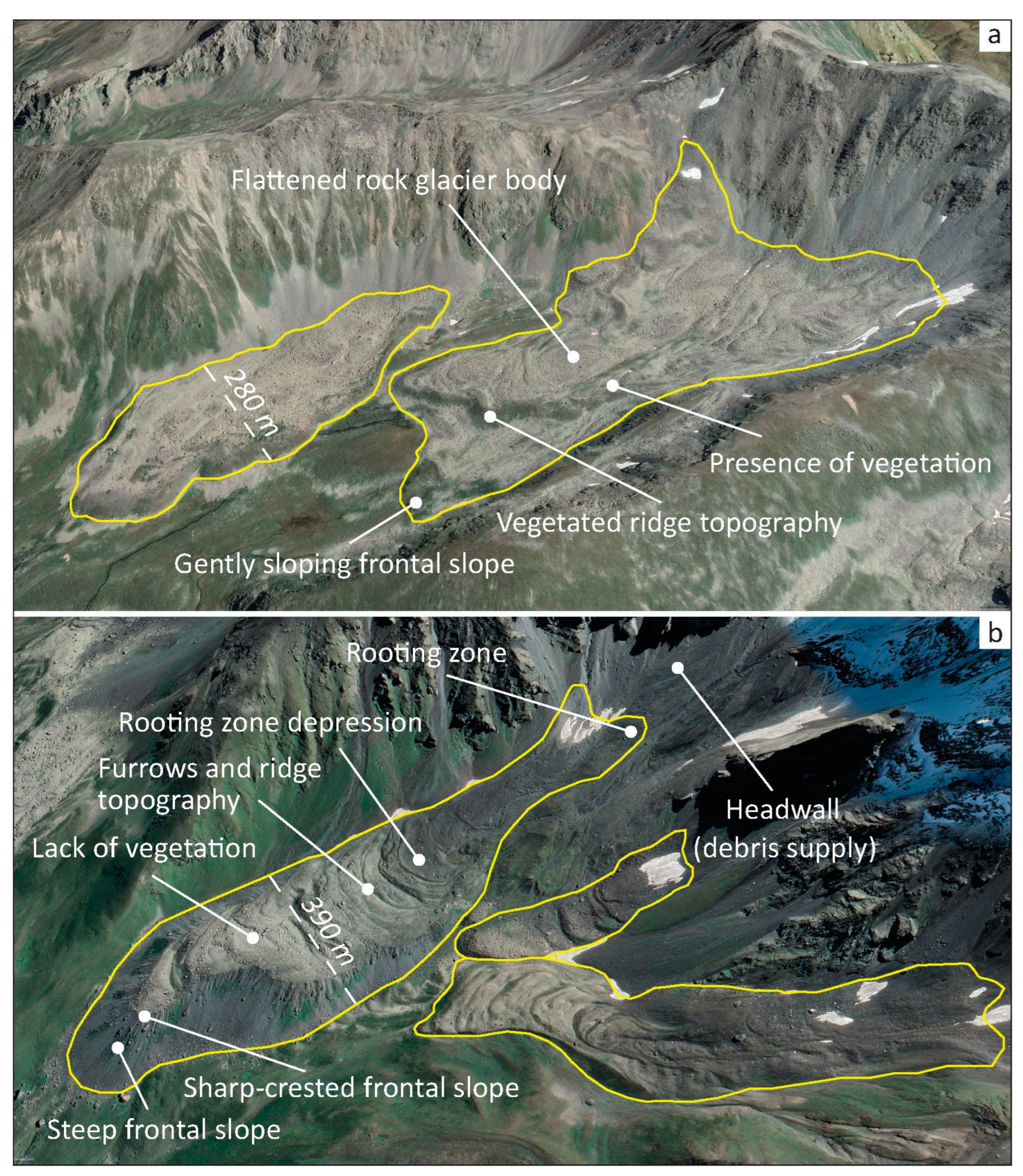
For mapped rock glaciers across the Greater Caucasus, a remote sensing approach was used based on geomorphological evidence such as lateral margins and steep front, ridges and furrows, collapse structures, flow structures, and distinct changes of the slope in the rooting zone [42,44,75] (Figure 2). Identification of the rock glacier snout was relatively simple while the accurate detection of the upper margin was sometimes challenging [43,77]. The upper boundary was defined according to the recommendations by Brardinoni et al. [43] and RGIK [44].
Delineation of rock glaciers is often challenging, especially distinguishing them from debris-covered glaciers and protalus and pronival ramparts [78,79]. Morphological similarities between these landforms may cause incorrect delineation of rock glacier margins and thus inaccurate area estimation of entire landforms. Although several approaches have been suggested [80,81], automatic mapping remains problematic and requires supervision [82,83]. We therefore used an optimal approach and digitized them manually to generate this inventory [11,42]. To reduce the misclassified areas, we carried out multiple adjustments of the outlines by at least two operators based on local and expert knowledge. However, this does not completely avoid the bias of the subjective interpretation of the operators. For this purpose, we used a buffer method, which gave us a certain ± uncertainty for each rock glacier outline (see Section 4.4 below).
4.2. Rock Glacier Classification
When classifying rock glaciers in their activity state, we used the morphological classification proposed by Barsch [84] and developed by the International Permafrost Association (IPA) Action Group on Rock Glaciers Inventories and Kinematics [44]. As a result, two categories of rock glacier activity were distinguished: relict, and active (Figure 2). Despite all our efforts, morphological characteristics remain a proxy for activity and the classification remains inherently challenging and uncertain [85,86].
Active rock glaciers present an over-steepened front, with an angle exceeding the angle of repose of the material and signs of ongoing erosional processes. This feature is often remarkable in remote sensing data due to its different colors or due to the existence of shadows and snow. The surface of active rock glaciers consists of large coarse clastic material. Moreover, furrows and ridges, which are formed as a result of cohesive flow of permafrost creep, are often distinguished on their surface [87].
According to the IPA guidelines [44], we interpreted relict rock glaciers as an evidence of past permafrost creep. Surface relief of relict rock glaciers is much more subdued than for active ones [84]. Often, they have a less steep front compared to active counterparts. Relict rock glaciers often present a vegetated surface but are recognizable in the landscape due to their morphology, sometimes still conserving distinct furrows and ridges. They are typically found at lower altitudes than active rock glaciers [44,84,88,89]. The expert-based discrimination from glacial moraines is completed by at least two expert interpretations, on the basis of the glacial and periglacial evolution of the landscape during the Holocene.
4.3. Topographic Features
We extracted and recorded topographic landform characteristics for each rock glacier, such as elevation (minimum, mean, and maximum), slope, and geographic coordinates (latitude and longitude) at the centroid. The topographic attributes were calculated in ArcGIS by draping the polygons over the DEM. The minimum elevation is the minimum value bounded by the polygons. The same applied to the maximum elevation. In a geomorphological sense, these two variables represent the lower point at the front and the higher point at the rooting zone, respectively. The mean elevation is finally the average between the minimum and maximum elevations. Surface area (km2) of the digitized rock glacier polygons was calculated using ArcMap 10.8.2 software. According to the IPA guidelines [44], the area of the smallest rock glacier digitized during the inventory was 0.01 km2. All of the parameters were entered in the attributes table (Table 1).
4.4. Uncertainty Assessment
Mapping uncertainty is derived from the resolution of the aerial imagery in terms of visibility of features and by the contrast between the rock glacier and the surrounding area. We attempted to estimate this uncertainty using the buffer method as it is often used for alpine glaciers [55,90]. For debris-covered glaciers that are not obscured by clouds, a 2-pixel buffer was suggested [91,92]. Our primary satellite imagery has a pixel resolution of up to 5 m. Since rock glaciers are often more challenging to delineate than alpine debris-covered glaciers [78], we increased the buffer size to 3-pixel and a 15 m buffer was generated around the digitized rock glacier using ArcGIS 10.8.2 software. Thus, the average ratio between the area with a buffer increment and the original rock glacier area was calculated and interpreted as an uncertainty. Overall, calculated uncertainty of the total rock glacier area for the entire Greater Caucasus was ±23.0 km2 or ±7.7 %. However, the buffer method included the relative higher error of small polygons as a small rock glacier has relatively more edge pixels [90].
We used the standard deviation (or σ) method to estimate the spread of the elevation of the rock glaciers, as well as for the values of the slope angle. This method is a measure of how spread the data is in relation to the mean. For example, a low standard deviation means data are clustered around the mean (a short and compact rock glacier), and a high standard deviation indicates data are more spread out (a long rock glacier distributed over a large range of elevation—or slope). Uncertainty for elevation measurements was spread between ±80–100 m, while it was ±3–5° for the slope inclination
5. Results
Based on high- and medium-resolution satellite imagery from 2004–2021 we have identified and mapped 1461 rock glaciers in the Greater Caucasus. Our inventory covered 34 river basins, and the total area of all Caucasus rock glaciers was 297.8 ± 23.0 km2 (Table 2). Within this inventory, 1018 rock glaciers (67%) with a total area of 199.6 ± 15.9 km2 were classified as active, while the 443 rock glaciers (33%) with a total area of 98.2 ± 7.2 km2 were classified as relict. Active rock glaciers had an average area of 0.20 km2, and the mean area of relict rock glaciers was 0.22 km2.
The distribution of rock glaciers within the countries that occupy the Greater Caucasus shows that 974 rock glaciers (212.0 ± 16.0 km2, 71.2%) were found in Russia, 481 (84.8 ± 7.0 km2, 28.5 %) in Georgia, and 6 (1.01 ± 0.08 km2, 0.3%) in Azerbaijan (Table 3).
Based on the physical geographical and climatological divisions of the Greater Caucasus we divided our dataset into five geographic subregions (westerns, central, eastern, northern, and southern). The northern slopes of the Greater Caucasus contained nearly 87% of all rock glaciers from the entire mountain range, or 1267 rock glaciers with a total area of 271.7 ± 20.5 km2 (Figure 3). The number distribution by sections was inhomogeneous. The eastern Greater Caucasus contained 610 rock glaciers with the total area of 127.4 ± 9.7 km2. The central and western sections had 460 and 391 rock glaciers with a total area of 103.1 ± 8.3 and 67.4 ± 5.4 km2, respectively (Figure 3). The spatial distribution of active and relict rock glaciers for western, central, and eastern Greater Caucasus is shown on the color-coded map in Figure 4.
The average minimum elevation of all Caucasus rock glaciers was 2282 ± 87 m a.s.l., while the average maximum elevation was 3153 ± 92 m a.s.l. (Figure 5a). Relict rock glaciers had lower mean average snout position at 2716 ± 83 m a.s.l., while active rock glaciers had higher mean average snout positions at 2955 ± 98 m a.s.l. (Figure 5b).
The distribution of rock glaciers by mean elevation varied between western, central, and eastern Greater Caucasus (Figure 6). The mean elevation of the rock glaciers was lowest in the western section and mainly ranged from 2000 to 3200 m a.s.l., while it varied between 2600 and 3700 in the central, and between 2900 and 3700 m a.s.l. in the eastern regions, respectively. The mean average elevation for all Caucasus rock glaciers was 3009 m a.s.l. The spatial distribution of mean elevation for all Caucasus rock glaciers is shown on the color-coded map in Figure 7.
The difference between the mean average surface slope was minor between active (41.4 ± 3°) and relict (38.8 ± 4°) rock glaciers in the entire mountain region, as it is within the uncertainty. Some differences in slope were present between the different sections, e.g., rock glaciers in the western Greater Caucasus had the least inclined surface with the mean average slope of 35.9 ± 4°, while the central and eastern had relatively higher slope (42.7 ± 3° and 42.2 ± 3°, respectively). The difference in the mean average surface slope was also insignificant between southern and northern slopes. Rock glaciers found on the southern slopes had the mean average slope of 43.4 ± 3°, while the northern counterparts had the mean average slope of 40.2 ± 3° (Figure 8a). Figure 8b shows the spatial distribution of mean elevation versus average slope for all rock glaciers larger than 0.01 km2 in the Greater Caucasus.
6. Discussion
This rock glacier inventory identified 1461 landforms, from which 1018 were classified as active, and 443 as relict. This number of rock glaciers in the Greater Caucasus and their existence at higher elevations emphasizes the importance of these landforms.
6.1. Possible Factors Controlling Rock Glacier Distribution
We interpreted the observed difference in the distribution of rock glaciers in the Greater Caucasus as a reflection of lithology, topography, climate, and its glaciation history [47,93]. The landscape of the central Greater Caucasus is mainly composed of crystalline slates, quartz diorites, Proterozoic and lower Paleozoic plagiogneisses, and plagiogranites [46], which are not prone to the formation of sediments and rock glaciers due to their resistance to erosion. Jurassic sedimentary rocks are dominated in lithology of some river basins in the eastern Greater Caucasus. These types of rock are characterized by relatively high erosion rates [47,94] and a better support formation of rock glaciers. The relatively low hypsometry of the western range can explain the lower number of rock glaciers and their lower average elevation and slope. In addition, higher precipitation rates in the western Greater Caucasus, due to closer proximity to the Black Sea, might promote the existence of more ice and thus lower elevations of the rock glaciers, although this topic needs further investigation.
6.2. Comparison with Other Mountain Ranges
Direct comparisons of our findings with other studies from the Caucasus are difficult due to the lack of previous data, i.e., none of the earlier works provide regional information of rock glaciers in digital form, which makes such a comparison impossible. Complete inventories for other mountain ranges are also relatively rare. However, similar rock glacier inventories based on high-resolution imagery using comparable methods have been recently published for the Austrian Alps where Wagner et al. [42] observed an average minimum elevation for all Austrian rock glaciers at 2276 m a.s.l. This is very similar with our data for all Caucasus rock glaciers (2282 m a.s.l.). In the Austrian Alps, the snout of the relict rock glaciers is situated at lower elevations than the active rock glaciers (median difference of 457 m for all rock glaciers) which is also comparable with the parameters inferred from the inventoried rock glaciers of the Greater Caucasus confirming that the relict rock glaciers have relatively lower (239 m) minimum elevation than those active rock glaciers.
We note that a more comparative analysis with results in any other mountain regions could be a topic for separate independent future research.
6.3. Mapping Uncertainty
The main sources of uncertainty, where the classification and mapping can potentially be improved in the next version, include but are not limited to: lack of clear geomorphological features of the object; errors of classification such as rock glaciers versus debris-covered glaciers; active rock glaciers versus relict forms (Figure 9); interactions with recent glaciations; talus slopes; truncated front in gullies. Uncertainties of mapping can arise mainly due to the insufficient quality of the initial data such as satellite imagery and DEM (cloudiness, snow, poor lighting, and coarse resolution), cartographic resolution of Google Earth Pro (distances, and elevation), and differences in resolution between dates of imagery. However, our total uncertainty (7.7%) does not exceed the recommended maximum uncertainty (approximately 10%) by the IPA Action Group [44] while mapping rock glaciers.
7. Conclusions
In this study, we present the first systematic inventory of rock glaciers for the entire Greater Caucasus region. The dataset includes polygons and characteristics of 1461 rock glaciers from different parts of this mountain region. Furthermore, it also enables the comparison of rock glaciers for different countries (Russia, Georgia, Azerbaijan), slopes—according to the location relative to the main watershed of the range (northern vs. southern), sections—based on physical geographical division (western, central, and eastern), and river basins—according to the hydrological catchment. A consistent attribution that was created during this study also enabled us to compare this with other inventories from different mountain regions and provided additional data for the modelling of the spatial distribution of permafrost in the Greater Caucasus.
Most of the landforms (1018 rock glaciers) were classified as active, while the remaining rock glaciers (443) were interpreted as relict. Active rock glaciers had a relatively smaller mean area than relict rock glaciers. Distribution of the rock glaciers were inhomogeneous according to the slopes and sections. Rock glaciers on the southern slopes had relatively lower mean elevation than those on the northern counterparts. Rock glaciers in the western Greater Caucasus reside at statistically significantly lower mean elevations than those in the central and eastern. We observed no significant difference in surface slopes between active and relict rock glaciers throughout the entire mountain region.
The main source of error in our database was related to the resolution of imagery, seasonal snow, shadows, and the classification strategy or interpretation. However, this rock glacier inventory is not a final product but only the first step towards a systematic approach for the entire Greater Caucasus, which will allow to improve these errors in the next version.
Future work should focus on more detailed field investigations; careful digitization and classification of rock glaciers; velocity measurements (in situ and from space), and classification of destabilized landforms, as well as their relationship with meteorological conditions along with climate analysis; measurement of ice and permafrost presence by ground-penetrating radar and electrical resistivity tomography; hydrogeological impact of rock glaciers, such as storage capacity and discharge dynamics. In addition, absolute age dating of the rock glaciers using the Terrestrial Cosmogenic Nuclide Dating has not yet been completed in this region; increasing interest in using this technique to better understand rock glacier role in palaeo-climate reconstruction.
Author Contributions
Conceptualization, L.G.T.; methodology, L.G.T., A.C. and G.A.N.; software, L.G.T. and G.A.N.; validation, L.G.T., A.C. and G.A.N.; formal analysis, L.G.T., A.C. and G.A.N.; investigation, L.G.T. and G.A.N.; writing—original draft preparation, L.G.T., A.C., G.A.N. and S.R.E.; review and editing, L.G.T., A.C., G.A.N. and S.R.E.; visualization, L.G.T., A.C., G.A.N. and S.R.E. All authors have read and agreed to the published version of the manuscript.
Funding
This work was supported by Shota Rustaveli National Science Foundation of Georgia (SRNSFG; grant no. YS-22-171).
Data Availability Statement
The newly created dataset is openly available in Zenodo https://doi.org/10.5281/zenodo.7808624 (accessed on 5 April 2023). It will also be openly accessible in GLIMS https://www.glims.org/maps/glims (accessed on 16 December 2022).
Acknowledgments
We would like to thank four anonymous reviewers for their constructive and useful comments and recommendations which clearly enhanced the quality of the paper.
Conflicts of Interest
The authors declare no conflict of interest.
References
- Barsch, D. Permafrost creep and rockglaciers. Permafr. Periglac. Process. 1992, 3, 175–188. [Google Scholar] [CrossRef]
- Haeberli, W.; Hallet, B.; Arenson, L.; Elconin, R.; Humlum, O.; Kääb, A.; Kaufmann, V.; Ladanyi, B.; Matsuoka, N.; Springman, S.; et al. Permafrost creep and rock glacier dynamics. Permafr. Periglac. Process. 2006, 17, 189–214. [Google Scholar] [CrossRef]
- Cicoira, A.; Marcer, M.; Gärtner-Roer, I.; Bodin, X.; Arenson, L.U.; Vieli, A. A general theory of rock glacier creep based on in-situ and remote sensing observations. Permafr. Periglac. Process. 2021, 32, 139–153. [Google Scholar] [CrossRef]
- Berthling, I.; Etzelmüller, B.; Eiken, T.; Sollid, J.L. Rock glaciers on Prins Karls Forland, Svalbard. I: Internal structure, flow velocity and morphology. Permafr. Periglac. Process. 1998, 9, 135–145. [Google Scholar] [CrossRef]
- Roer, I.; Haeberli, W.; Avian, M.; Kaufmann, V.; Delaloye, R.; Lambiel, C.; Kääb, A. Observations and considerations on destabilizing active rock glaciers in the European Alps. In Proceedings of the 9th International Conference on Permafrost, Fairbanks, Alaska, 29 June–3 July 2008; pp. 1505–1510. [Google Scholar] [CrossRef]
- Kellerer-Pirklbauer, A.; Kaufmann, V. Deglaciation and its impact on permafrost and rock glacier evolution: New insight from two adjacent cirques in Austria. Sci. Total Environ. 2017, 621, 1397–1414. [Google Scholar] [CrossRef]
- Scotti, R.; Crosta, G.B.; Villa, A. Destabilisation of Creeping Permafrost: The Plator Rock Glacier Case Study (Central Italian Alps). Permafr. Periglac. Process. 2017, 28, 224–236. [Google Scholar] [CrossRef] [Green Version]
- Cannone, N.; Piccinelli, S. Changes of rock glacier vegetation in 25 years of climate warming in the Italian Alps. CATENA 2021, 206, 105562. [Google Scholar] [CrossRef]
- Giaccone, E.; Luoto, M.; Vittoz, P.; Guisan, A.; Mariéthoz, G.; Lambiel, C. Influence of microclimate and geomorphological factors on alpine vegetation in the Western Swiss Alps. Earth Surf. Process. Landforms 2019, 44, 3093–3107. [Google Scholar] [CrossRef] [Green Version]
- Millar, C.I.; Westfall, B.; Delany, D.L. Thermal and hydrologic attributes of rock glaciers and periglacial talus landforms: Sierra Nevada, California, USA. Quat. Int. 2013, 310, 169–180. [Google Scholar] [CrossRef]
- Rangecroft, S.; Harrison, S.; Anderson, K.; Magrath, J.; Castel, A.P.; Pacheco, P. A First Rock Glacier Inventory for the Bolivian Andes. Permafr. Periglac. Process. 2014, 25, 333–343. [Google Scholar] [CrossRef]
- Bosson, J.-B.; Lambiel, C. Internal Structure and Current Evolution of Very Small Debris-Covered Glacier Systems Located in Alpine Permafrost Environments. Front. Earth Sci. 2016, 4, 39. [Google Scholar] [CrossRef] [Green Version]
- Lugon, R.; Stoffel, M. Rock-glacier dynamics and magnitude–frequency relations of debris flows in a high-elevation watershed: Ritigraben, Swiss Alps. Glob. Planet. Chang. 2010, 73, 202–210. [Google Scholar] [CrossRef]
- Kummert, M.; Bodin, X.; Braillard, L.; Delaloye, R. Pluri-decadal evolution of rock glaciers surface velocity and its impact on sediment export rates towards high alpine torrents. Earth Surf. Process. Landf. 2021, 46, 3213–3227. [Google Scholar] [CrossRef]
- Kofler, C.; Mair, V.; Gruber, S.; Todisco, M.C.; Nettleton, I.; Steger, S.; Zebisch, M.; Schneiderbauer, S.; Comiti, F. When do rock glacier fronts fail? Insights from two case studies in South Tyrol (Italian Alps). Earth Surf. Process. Landf. 2021, 46, 1311–1327. [Google Scholar] [CrossRef]
- Haeberli, W.; Brandova, D.; Burga, C.; Egli, M.; Frauenfelder, R.; Kääb, A.; Maisch, M.; Mauz, B.; Dikau, R. Methods for absolute and relative age dating of rock-glacier surfaces in Alpine permafrost. In Proceedings of the 8th International Conference on Permafrost 2003, Zürich, Switzerland, 21–25 July 2003; Volume 1, pp. 343–348. [Google Scholar]
- Refsnider, K.A.; Brugger, K.A. Rock Glaciers in Central Colorado, U.S.A., as Indicators of Holocene Climate Change. Arct. Antarct. Alp. Res. 2007, 39, 127–136. [Google Scholar] [CrossRef]
- Amschwand, D.; Ivy-Ochs, S.; Frehner, M.; Steinemann, O.; Christl, M.; Vockenhuber, C. Deciphering the evolution of the Bleis Marscha rock glacier (Val d’Err, eastern Switzerland) with cosmogenic nuclide exposure dating, aerial image correlation, and finite element modeling. Cryosphere 2021, 15, 2057–2081. [Google Scholar] [CrossRef]
- Scapozza, C.; Del Siro, C.; Lambiel, C.; Ambrosi, C. Schmidt hammer exposure-age dating of periglacial and glacial landforms in the Southern Swiss Alps based on R-value calibration using historical data. Geogr. Helv. 2021, 76, 401–423. [Google Scholar] [CrossRef]
- Lehmann, B.; Anderson, R.S.; Bodin, X.; Cusicanqui, D.; Valla, P.G.; Carcaillet, J. Alpine rock glacier activity over Holocene to modern timescales (western French Alps). Earth Surf. Dyn. 2022, 10, 605–633. [Google Scholar] [CrossRef]
- Janke, J.R. Modeling past and future alpine permafrost distribution in the Colorado Front Range. Earth Surf. Process. Landf. 2005, 30, 1495–1508. [Google Scholar] [CrossRef]
- Deluigi, N.; Lambiel, C.; Kanevski, M. Data-driven mapping of the potential mountain permafrost distribution. Sci. Total Environ. 2017, 590, 370–380. [Google Scholar] [CrossRef] [Green Version]
- Marcer, M.; Bodin, X.; Brenning, A.; Schoeneich, P.; Charvet, R.; Gottardi, F. Permafrost Favorability Index: Spatial Modeling in the French Alps Using a Rock Glacier Inventory. Front. Earth Sci. 2017, 5, 105. [Google Scholar] [CrossRef] [Green Version]
- Kääb, A.; Frauenfelder, R.; Roer, I. On the response of rockglacier creep to surface temperature increase. Glob. Planet. Chang. 2007, 56, 172–187. [Google Scholar] [CrossRef]
- Scapozza, C.; Lambiel, C.; Bozzini, C.; Mari, S.; Conedera, M. Assessing the rock glacier kinematics on three different timescales: A case study from the southern Swiss Alps. Earth Surf. Process. Landf. 2014, 39, 2056–2069. [Google Scholar] [CrossRef] [Green Version]
- Cicoira, A.; Beutel, J.; Faillettaz, J.; Gärtner-Roer, I.; Vieli, A. Resolving the influence of temperature forcing through heat conduction on rock glacier dynamics: A numerical modelling approach. Cryosphere 2019, 13, 927–942. [Google Scholar] [CrossRef] [Green Version]
- Marcer, M.; Cicoira, A.; Cusicanqui, D.; Bodin, X.; Echelard, T.; Obregon, R.; Schoeneich, P. Rock glaciers throughout the French Alps accelerated and destabilised since 1990 as air temperatures increased. Commun. Earth Environ. 2021, 2, 81. [Google Scholar] [CrossRef]
- Arenson, L.U.; Harrington, J.S.; Koenig, C.E.M.; Wainstein, P.A. Mountain Permafrost Hydrology—A Practical Review Following Studies from the Andes. Geosciences 2022, 12, 48. [Google Scholar] [CrossRef]
- Wirz, V.; Beutel, J.; Gruber, S.; Gubler, S.; Purves, R.S. Estimating velocity from noisy GPS data for investigating the temporal variability of slope movements. Nat. Hazards Earth Syst. Sci. 2014, 14, 2503–2520. [Google Scholar] [CrossRef] [Green Version]
- Ikeda, A.; Matsuoka, N.; Kääb, A. Fast deformation of perennially frozen debris in a warm rock glacier in the Swiss Alps: An effect of liquid water. J. Geophys. Res. Atmos. 2008, 113, F01021. [Google Scholar] [CrossRef] [Green Version]
- Buchli, T.; Kos, A.; Limpach, P.; Merz, K.; Zhou, X.; Springman, S.M. Kinematic investigations on the Furggwanghorn Rock Glacier, Switzerland. Permafr. Periglac. Process. 2018, 29, 3–20. [Google Scholar] [CrossRef]
- Cicoira, A.; Beutel, J.; Faillettaz, J.; Vieli, A. Water controls the seasonal rhythm of rock glacier flow. Earth Planet. Sci. Lett. 2019, 528, 115844. [Google Scholar] [CrossRef]
- Noetzli, J.; Pellet, C.; Staub, B. (Eds.) Permafrost in Switzerland 2014/2015 to 2017/2018. Glaciological Report (Permafrost) 2019. No. 16-19 of the Cryospheric Commission of the Swiss Academy of Sciences; Swiss Permafrost Monitoring Network (PERMOS): Fribourg, Switzerland, 2019; 104p. [Google Scholar] [CrossRef]
- Kääb, A.; Strozzi, T.; Bolch, T.; Caduff, R.; Trefall, H.; Stoffel, M.; Kokarev, A. Inventory and changes of rock glacier creep speeds in Ile Alatau and Kungöy Ala-Too, northern Tien Shan, since the 1950s. Cryosphere 2021, 15, 927–949. [Google Scholar] [CrossRef]
- Hartl, L.; Zieher, T.; Bremer, M.; Stocker-Waldhuber, M.; Zahs, V.; Höfle, B.; Klug, C.; Cicoira, A. Multi-sensor monitoring and data integration reveal cyclical destabilization of the Äußeres Hochebenkar rock glacier. Earth Surf. Dyn. 2023, 11, 117–147. [Google Scholar] [CrossRef]
- Krainer, K.; Mostler, W. Hydrology of Active Rock Glaciers: Examples from the Austrian Alps. Arctic, Antarct. Alp. Res. 2002, 34, 142–149. [Google Scholar] [CrossRef]
- Pruessner, L.; Huss, M.; Farinotti, D. Temperature evolution and runoff contribution of three rock glaciers in Switzerland under future climate forcing. Permafr. Periglac. Process. 2022, 33, 310–322. [Google Scholar] [CrossRef]
- Kellerer-Pirklbauer, A.; Lieb, G.K.; Kleinferchner, H. A New Rock Glacier Inventory of the Eastern European Alps. Austrian J. Earth Sci. 2012, 105, 78–93. [Google Scholar]
- Sattler, K.; Anderson, B.; Mackintosh, A.; Norton, K.; de Róiste, M. Estimating Permafrost Distribution in the Maritime Southern Alps, New Zealand, Based on Climatic Conditions at Rock Glacier Sites. Front. Earth Sci. 2016, 4, 1–17. [Google Scholar] [CrossRef] [Green Version]
- Ambrosi, C.; Castelletti, C.; Scapozza, C.; Czerski, D.; Schenker, F. The new landslide and rock glacier inventory map of Canton Ticino. Geophysical Research Abstracts 20 2018, EGU2018-2358, General Assembly.
- Marcer, M.; Serrano, C.; Brenning, A.; Bodin, X.; Goetz, J.; Schoeneich, P. Evaluating the destabilization susceptibility of active rock glaciers in the French Alps. Cryosphere 2019, 13, 141–155. [Google Scholar] [CrossRef] [Green Version]
- Wagner, T.; Pleschberger, R.; Kainz, S.; Ribis, M.; Kellerer-Pirklbauer, A.; Krainer, K.; Philippitsch, R.; Winkler, G. The first consistent inventory of rock glaciers and their hydrological catchments of the Austrian Alps. Austrian J. Earth Sci. 2020, 113, 1–23. [Google Scholar] [CrossRef]
- Brardinoni, F.; Scotti, R.; Sailer, R.; Mair, V. Evaluating sources of uncertainty and variability in rock glacier inventories. Earth Surf. Process. Landf. 2019, 44, 2450–2466. [Google Scholar] [CrossRef]
- RGIK. Towards Standard Guidelines for Inventorying Rock Glaciers: Baseline Concepts (Version 4.2.2); IPA Action Group Rock Glacier Inventories and Kinematics: Norce, Norway, 2022; 13p. [Google Scholar]
- Millar, C.I.; Westfall, R.D. Geographic, hydrological, and climatic significance of rock glaciers in the Great Basin, USA. Arct. Antarct. Alp. Res. 2019, 51, 232–249. [Google Scholar] [CrossRef] [Green Version]
- Gvozdetsky, N.A.; Golubchikov, Y.N. Mountains. Series: Nature of the World; Thought: Moscow, Russia, 1987; p. 399. (In Russia) [Google Scholar]
- Gobejishvili, R.; Lomidze, N.; Tielidze, L. Late Pleistocene (Wurmian) glaciations of the Caucasus. In Quaternary Glaciations: Extent and Chronology 2011; Ehlers, J., Gibbard, P.L., Hughes, P.D., Eds.; Elsevier: Amsterdam, The Netherlands, 2011; pp. 141–147. [Google Scholar] [CrossRef]
- Tsereteli, N.; Tibaldi, A.; Alania, V.; Gventsadse, A.; Enukidze, O.; Varazanashvili, O.; Müller, B. Active tectonics of central-western Caucasus, Georgia. Tectonophysics 2016, 691, 328–344. [Google Scholar] [CrossRef]
- Ismail-Zadeh, A.; Adamia, S.; Chabukiani, A.; Chelidze, T.; Cloetingh, S.; Floyd, M.; Gorshkov, A.; Gvishiani, A.; Ismail-Zadeh, T.; Kaban, M.K.; et al. Geodynamics, seismicity, and seismic hazards of the Caucasus. Earth-Sci. Rev. 2020, 207, 103222. [Google Scholar] [CrossRef]
- Volodicheva, N. The Caucasus. In The Physical Geography of Northern Eurasia; Shahgedanova, M., Ed.; Oxford University Press: Oxford, UK, 2002; pp. 350–376. [Google Scholar]
- Kozachek, A.; Mikhalenko, V.; Masson-Delmotte, V.; Ekaykin, A.; Ginot, P.; Kutuzov, S.; Legrand, M.; Lipenkov, V.; Preunkert, S. Large-scale drivers of Caucasus climate variability in meteorological records and Mt El’brus ice cores. Clim. Past 2017, 13, 473–489. [Google Scholar] [CrossRef] [Green Version]
- Tielidze, L.; Svanadze, D.; Gadrani, L.; Asanidze, L.; Wheate, R.D.; Hamilton, G.S. A 54-year record of changes at Chalaati and Zopkhito glaciers, Georgian Caucasus, observed from archival maps, satellite imagery, drone survey and ground-based investigation. Hung. Geogr. Bull. 2020, 69, 175–189. [Google Scholar] [CrossRef]
- Kutuzov, S.S.; Mikhalenko, V.N.; Grachev, A.M.; Ginot, P.; Lavrentiev, I.I.; Kozachek, A.V.; Krupskaya, V.V.; Ekaykin, A.A.; Tielidze, L.G.; Toropov, P.A. First geophysical and shallow ice core investigation of the Kazbek plateau glacier, Caucasus Mountains. Environ. Earth Sci. 2016, 75, 1488. [Google Scholar] [CrossRef]
- Tielidze, L.G. Glacier change over the last century, Caucasus Mountains, Georgia, observed from old topographical maps, Landsat and ASTER satellite imagery. Cryosphere 2016, 10, 713–725. [Google Scholar] [CrossRef] [Green Version]
- Tielidze, L.G.; Wheate, R.D. The Greater Caucasus Glacier Inventory (Russia, Georgia and Azerbaijan). Cryosphere 2018, 12, 81–94. [Google Scholar] [CrossRef] [Green Version]
- Sylvén, M.; Reinvang, R.; Andersone-Lilley, Ž. Climate Change in Southern Caucasus: Impacts on nature, people and society. WWF overview report 2008. WWF Norway WWF Caucasus Programme.
- Tielidze, L.G.; Nosenko, G.A.; Khromova, T.E.; Paul, F. Strong acceleration of glacier area loss in the Greater Caucasus between 2000 and 2020. Cryosphere 2022, 16, 489–504. [Google Scholar] [CrossRef]
- Tushinskiy, G.K. (Ed.) Glaciation of Elbrus; Publishing House of Moscow State University: Moscow, Russia, 1968; 343p. (In Russian) [Google Scholar]
- Krasnoslobodtsev, I.S. About Rock Glaciers of the Greater Caucasus. In Bulletin of Moscow State University; Geography Series. No. 1; Publishing House of Moscow State University: Moscow, Russia, 1971; pp. 95–97. (In Russian) [Google Scholar]
- Brukhanda, V.I. Rock glaciers of the Caucasus and Pamir-Alay and their connection with glacier surges. Mater. Glaciol. Stud. 1976, 63–70. (In Russian) [Google Scholar]
- Gobejishvili, R.G. Rock glaciers of Georgia. Communications of the Academy of Sciences of the Georgian SSR. Phys. Geogr. 1978, 90, 93–95. (In Russian) [Google Scholar]
- Gobejishvili, R.G.; Rekhviashvili, A.V. Modern and relict rock glaciers of the Sugan Range (Central Caucasus). Work. Geogr. Soc. Georgian SSR 1988, 12–19. (In Russian) [Google Scholar]
- Rekhviashvili, A.V.; Gobejishvili, R.G. Modern and relict rock glaciers of Svaneti. Mater. Glaciol. Res. 1990, 117–120. (In Russian) [Google Scholar]
- Kozhevnikov, A.V.; Nikitin, M.Y.; Lian, R.N. Rock glaciers of the mountainous Dagestan (Eastern Caucasus). In Bulletin of Moscow State University; Geology Series. No. 2; Moscow State University: Moscow, Russia, 1980; pp. 14–26. (In Russian) [Google Scholar]
- Seinova, I.V.; Mezhenina, T.N. Rock glaciers are the centers of the origin of mudflows in the basin of the river Chegem. Mater. Glaciol. Res. 1987, 179–183. [Google Scholar]
- Dokukin, M.D. Types of marine relief and flood hazard (on the example of the northern slope of the Central Caucasus). Abstract of diss. cand. geogr. n. M. 1993; 22p. (In Russian) [Google Scholar]
- Volodicheva, N.A.; Labutina, I.A. Rock glaciers of the Elbrus region. Mater. Glaciol. Stud. 1996; 98–102. (In Russian) [Google Scholar]
- Tavasiev, R.A. Rock glaciers of North Ossetia and their importance for the development of mountain territories. In Bulletin of the Vladikavkaz Scientific Center 2011; T. 11, No. 3; Vladikavkaz Scientific Center: Vladikavkaz, Russia, 2011; pp. 48–54. (In Russian) [Google Scholar]
- Jones, D.B.; Harrison, S.; Anderson, K.; Betts, R.A. Mountain rock glaciers contain globally significant water stores. Sci. Rep. 2018, 8, 2834. [Google Scholar] [CrossRef] [PubMed] [Green Version]
- Tielidze, L.G.; Jomelli, V.; Nosenko, G.A. Analysis of Regional Changes in Geodetic Mass Balance for All Caucasus Glaciers over the Past Two Decades. Atmosphere 2022, 13, 256. [Google Scholar] [CrossRef]
- ESRI ArcGIS. Available online: https://www.arcgis.com/home/item.html?id=10df2279f9684e4a9f6a7f08febac2a9 (accessed on 11 October 2022).
- Tielidze, L.G.; Eaves, S.R.; Norton, K.P.; Mackintosh, A.N. Glacial geomorphology of the Ahuriri River valley, central Southern Alps, New Zealand. J. Maps 2021, 17, 73–86. [Google Scholar] [CrossRef]
- Raup, B.H.; Khalsa, S.J.S.; Armstrong, R.L.; Sneed, W.A.; Hamilton, G.S.; Paul, F.; Cawkwell, F.; Beedle, M.J.; Menounos, B.P.; Wheate, R.D.; et al. Quality in the GLIMS glacier database. In Global Land Ice Measurements from Space 2014; Kargel, J.S., Leonard, G.J., Bishop, M.P., Kääb, A., Raup, B.H., Eds.; Springer: Berlin/Heidelberg, Germany, 2014; pp. 163–182. [Google Scholar] [CrossRef]
- Jones, D.; Harrison, S.; Anderson, K.; Selley, H.; Wood, J.; Betts, R. The distribution and hydrological significance of rock glaciers in the Nepalese Himalaya. Glob. Planet. Chang. 2018, 160, 123–142. [Google Scholar] [CrossRef] [Green Version]
- Schmid, M.-O.; Baral, P.; Gruber, S.; Shahi, S.; Shrestha, T.; Stumm, D.; Wester, P. Assessment of permafrost distribution maps in the Hindu Kush Himalayan region using rock glaciers mapped in Google Earth. Cryosphere 2015, 9, 2089–2099. [Google Scholar] [CrossRef] [Green Version]
- Charbonneau, A.A.; Smith, D.J. An inventory of rock glaciers in the central British Columbia Coast Mountains, Canada, from high resolution Google Earth imagery. Arct. Antarct. Alp. Res. 2018, 50, e1489026. [Google Scholar] [CrossRef] [Green Version]
- Krainer, K.; Ribis, M. A rock glacier inventory of the Tyrolean Alps (Austria). Austrian J. Earth Sci. 2012, 105, 32–47. [Google Scholar]
- Jarman, D.; Wilson, P.; Harrison, S. Are there any relict rock glaciers in the British mountains? J. Quat. Sci. 2013, 28, 131–143. [Google Scholar] [CrossRef]
- Hedding, D.W. Pronival ramparts: A review. Prog. Phys. Geogr. Earth Environ. 2016, 40, 835–855. [Google Scholar] [CrossRef]
- Marcer, M. Rock glaciers automatic mapping using optical imagery and convolutional neural networks. Permafr. Periglac. Process. 2020, 31, 561–566. [Google Scholar] [CrossRef]
- Robson, B.A.; Bolch, T.; MacDonell, S.; Hölbling, D.; Rastner, P.; Schaffer, N. Automated detection of rock glaciers using deep learning and object-based image analysis. Remote Sens. Environ. 2020, 250, 112033. [Google Scholar] [CrossRef]
- Brenning, A. Benchmarking classifiers to optimally integrate terrain analysis and multispectral remote sensing in automatic rock glacier detection. Remote Sens. Environ. 2009, 113, 239–247. [Google Scholar] [CrossRef]
- Shukla, A.; Gupta, R.P.; Arora, M.K. Delineation of debris-covered glacier boundaries using optical and thermal remote sensing data. Remote Sens. Lett. 2010, 1, 11–17. [Google Scholar] [CrossRef]
- Barsch, D. Rockglaciers. In Indicators for the Present and Former Geoecology in High Mountain Environments; Springer: Berlin, Germany, 1996; 331p. [Google Scholar] [CrossRef]
- Sorg, A.; Kääb, A.; Roesch, A.; Bigler, C.; Stoffel, M. Contrasting responses of Central Asian rock glaciers to global warming. Sci. Rep. 2015, 5, 8228. [Google Scholar] [CrossRef] [Green Version]
- Colucci, R.R.; Forte, E.; Žebre, M.; Maset, E.; Zanettini, C.; Guglielmin, M. Is that a relict rock glacier? Geomorphology 2019, 330, 177–189. [Google Scholar] [CrossRef] [Green Version]
- Lytkin, V. Inventory and Distribution of Rock Glaciers in Northeastern Yakutia. Land 2020, 9, 384. [Google Scholar] [CrossRef]
- Baroni, C.; Carton, A.; Seppi, R. Distribution and behaviour of rock glaciers in the Adamello–Presanella Massif (Italian Alps). Permafr. Periglac. Process. 2004, 15, 243–259. [Google Scholar] [CrossRef]
- Scotti, R.; Brardinoni, F.; Alberti, S.; Frattini, P.; Crosta, G.B. A regional inventory of rock glaciers and protalus ramparts in the central Italian Alps. Geomorphology 2013, 186, 136–149. [Google Scholar] [CrossRef]
- Bolch, T.; Menounos, B.; Wheate, R. Landsat-based inventory of glaciers in western Canada, 1985–2005. Remote Sens. Environ. 2010, 114, 127–137. [Google Scholar] [CrossRef]
- Frey, H.; Paul, F.; Strozzi, T. Compilation of a glacier inventory for the western Himalayas from satellite data: Methods, challenges, and results. Remote Sens. Environ. 2012, 124, 832–843. [Google Scholar] [CrossRef] [Green Version]
- Tielidze, L.G.; Bolch, T.; Wheate, R.D.; Kutuzov, S.S.; Lavrentiev, I.I.; Zemp, M. Supra-glacial debris cover changes in the Greater Caucasus from 1986 to 2014. Cryosphere 2022, 14, 585–598. [Google Scholar] [CrossRef] [Green Version]
- Kofler, C.; Steger, S.; Mair, V.; Zebisch, M.; Comiti, F.; Schneiderbauer, S. An inventory-driven rock glacier status model (intact vs. relict) for South Tyrol, Eastern Italian Alps. Geomorphology 2020, 350, 106887. [Google Scholar] [CrossRef]
- Bochud, M. Tectonics of the Eastern Greater Caucasus in Azerbaijan. Ph.D. Thesis, Faculty of Sciences of the University of Fribourg, Fribourg, Switzerland, 2011. [Google Scholar]
Figure 2.
An example of rock glacier mapping and classification: (a)—relict rock glaciers (43°38′21.36″ N 41°5′53.19″ E); (b)—active rock glaciers (42°32′54.05″ N 44°46′31.21″ E). The yellow line corresponds to the boundaries of the rock glacier. The white dashed line indicates the width of the rock glacier. Google Earth imagery 16/08/2019 and 16/08/2022 is used as the background. © Google Earth 2022.

Figure 3.
Rock glacier area and count comparison for the different sections and slopes of the Greater Caucasus.
Figure 3.
Rock glacier area and count comparison for the different sections and slopes of the Greater Caucasus.

Figure 4.
Color-coded map of active and relict rock glaciers for the Greater Caucasus.

Figure 5.
(a)—Individual rock glacier area versus maximum and minimum elevation for the entire Greater Caucasus. (b)—Individual rock glacier area versus minimum elevation (snout position) of relict and active rock glaciers for the entire Greater Caucasus.
Figure 5.
(a)—Individual rock glacier area versus maximum and minimum elevation for the entire Greater Caucasus. (b)—Individual rock glacier area versus minimum elevation (snout position) of relict and active rock glaciers for the entire Greater Caucasus.


Figure 6.
Mean average elevation of all rock glaciers inventoried across the Greater Caucasus according to the different sections (western, central, and eastern) and slopes (northern and southern). Error bars are based on standard deviation (1σ).
Figure 6.
Mean average elevation of all rock glaciers inventoried across the Greater Caucasus according to the different sections (western, central, and eastern) and slopes (northern and southern). Error bars are based on standard deviation (1σ).

Figure 7.
Color-coded map of mean elevation for all rock glaciers larger than 0.01 km2 in the Greater Caucasus.
Figure 7.
Color-coded map of mean elevation for all rock glaciers larger than 0.01 km2 in the Greater Caucasus.

Figure 8.
(a)—Mean average slope of all rock glaciers inventoried across the Greater Caucasus according to the different sections (western, central, and eastern) and slopes (northern and southern). Error bars are based on standard deviation (1σ). (b)—Spatial distribution of mean elevation versus average slope for all rock glaciers larger than 0.01 km2 in the Greater Caucasus.


Figure 9.
Examples of complex rock glacier terrain with hard-defined boundaries. (a)—active rock glaciers (upper part) versus relict rock glaciers (lower part) (43°30′6.58″ N 41°6′46.16″ E). (b)—debris-covered glacier (upper part) versus active rock glacier (lower part) (42°42′3.67″ N 44°50′44.61″ E). Google Earth imagery 26/10/2020 (a) and 22/09/2011 (b) is used as the background. © Google Earth 2022.


Table 1.
Rock glacier attributes obtained during the inventory.
| Attribute | Meaning |
|---|---|
| Latitude/Longitude | Coordinate |
| Area (km2) | Rock glacier total area |
| Maximum elevation (m a.s.l.) | Maximum elevation of the rock glacier |
| Mean elevation (m a.s.l.) | Mean elevation of the rock glacier |
| Minimum elevation (m a.s.l.) | Minimum elevation of the rock glacier front |
| Mean slope | Mean slope (°) of the surface |
| Class | Active/Relict |
| River basin | Main and tributary river basins |
| Region/section | Western/Central/Eastern |
| Macro-slope relative to the watershed | Northern/Southern |
| Country | Russia/Georgia/Azerbaijan |
Table 2.
The distribution of rock glaciers in the Greater Caucasus by slopes and individual river basins in order from west to east. Please also see Figure 1 for locations of river basins.
Table 2.
The distribution of rock glaciers in the Greater Caucasus by slopes and individual river basins in order from west to east. Please also see Figure 1 for locations of river basins.
| Main River Basin | Tributary River Basin | Satellite Imagery 2004–2021 | Mean Elevation (m a.s.l.) | |
|---|---|---|---|---|
| Count | Area km2 | |||
| Northern Slopes | ||||
| Kuban left tributaries | Belaya | 6 | 1.25 | 2232 |
| Malaya Laba | 40 | 4.70 | 2570 | |
| Bolshaya Laba | 70 | 10.23 | 2507 | |
| Bolshoy Zelenchuk | 64 | 12.69 | 2705 | |
| Maliy Zelenchuk | 76 | 11.34 | 2849 | |
| Teberda | 57 | 12.26 | 2931 | |
| Kuban headwaters | Daut | 10 | 1.96 | 2876 |
| Uchkulan | 18 | 5.62 | 3005 | |
| Ullukam | 25 | 4.44 | 2986 | |
| Khudes | 4 | 0.98 | 3137 | |
| Malka | 3 | 3.68 | 3090 | |
| Baksan | 74 | 19.65 | 3149 | |
| Chegem | 51 | 10.66 | 3228 | |
| Cherek | 58 | 11.70 | 3164 | |
| Urukh | 53 | 16.93 | 3139 | |
| Ardon | 51 | 8.98 | 3046 | |
| Fiagdon | 22 | 6.34 | 3074 | |
| Gizeldon | 10 | 4.26 | 3032 | |
| Tergi (Terek) headwaters | 185 | 35.19 | 3165 | |
| Sunja right tributaries | Assa | 62 | 16.24 | 3006 |
| Arghuni | 75 | 19.44 | 3075 | |
| Sharo Argun | 26 | 4.16 | 3146 | |
| Sulak | Andiyskoye Koysu | 103 | 18.69 | 3183 |
| Avarskoye Koysu | 96 | 21.88 | 3193 | |
| Samur | 19 | 6.51 | 3185 | |
| Kusarchai | 6 | 1.01 | 3484 | |
| Southern Slopes | ||||
| Mzimta | 3 | 0.70 | 2268 | |
| Bzipi | 6 | 0.33 | 2344 | |
| Kodori | 12 | 0.89 | 2609 | |
| Enguri | 74 | 12.70 | 2887 | |
| Rioni | 34 | 4.79 | 2877 | |
| Liakhvi | 30 | 3.36 | 2945 | |
| Aragvi | 24 | 3.42 | 3105 | |
| Alazani | 14 | 0.77 | 2940 | |
| Total, Greater Caucasus | 1461 | 297.80 | 3009 | |
Table 3.
The distribution of rock glaciers in the Greater Caucasus according to countries, ordered by count.
Table 3.
The distribution of rock glaciers in the Greater Caucasus according to countries, ordered by count.
| Countries | Satellite Imagery 2004–2021 | Mean Elevation (m a.s.l.) | |
|---|---|---|---|
| Count | Area km2 | ||
| Russia | 974 | 212.0 ± 16.0 | 2985 |
| Georgia | 481 | 84.8 ± 7.0 | 3052 |
| Azerbaijan | 6 | 1.01 ± 0.08 | 3484 |
Disclaimer/Publisher’s Note: The statements, opinions and data contained in all publications are solely those of the individual author(s) and contributor(s) and not of MDPI and/or the editor(s). MDPI and/or the editor(s) disclaim responsibility for any injury to people or property resulting from any ideas, methods, instructions or products referred to in the content. |
© 2023 by the authors. Licensee MDPI, Basel, Switzerland. This article is an open access article distributed under the terms and conditions of the Creative Commons Attribution (CC BY) license (https://creativecommons.org/licenses/by/4.0/).
Share and Cite
MDPI and ACS Style
Tielidze, L.G.; Cicoira, A.; Nosenko, G.A.; Eaves, S.R. The First Rock Glacier Inventory for the Greater Caucasus. Geosciences 2023, 13, 117. https://doi.org/10.3390/geosciences13040117
AMA Style
Tielidze LG, Cicoira A, Nosenko GA, Eaves SR. The First Rock Glacier Inventory for the Greater Caucasus. Geosciences. 2023; 13(4):117. https://doi.org/10.3390/geosciences13040117
Chicago/Turabian StyleTielidze, Levan G., Alessandro Cicoira, Gennady A. Nosenko, and Shaun R. Eaves. 2023. "The First Rock Glacier Inventory for the Greater Caucasus" Geosciences 13, no. 4: 117. https://doi.org/10.3390/geosciences13040117
Note that from the first issue of 2016, this journal uses article numbers instead of page numbers. See further details here.