1. Introduction
The best known examples of classification systems based on weathering forms are by German weathering scientists, such as Fitzner and colleagues [
1], who used weathering forms in conjunction with weathering products and profiles to assess limestone weathering. Their derived classification system for weathering forms and their intensities was site-specific to Cairo’s limestone historical monuments, entailing monument mapping and a quantitative rating of stone damage through damage categories and indices. Their results showed substantial impacts of salt weathering (from air pollution) in combination with the effects of rising humidity. Other researchers have also found there to be a salt-loading damage that is visible, as through alveolar weathering [
2]. Researchers Cassar and Vella [
3] took what appeared to be 90 identical samples of Lower Globigerina limestone of the Maltese islands and tested them for durability based on geochemical indicators (namely, SiO
2, Al
2O
3, K
2O, TiO
2, and Fe
2O
3). Warke and colleagues [
4] used a staging system approach (derived from the medical TNM Classification of Malignant Tumours) that involved controlling factors, including structural and mineralogical properties, inheritance effects, contaminant loading, and natural change. Incorporating a case study of St Patrick’s Church, Newtownards (near Belfast), North Ireland, they used a site record sheet to assess the west-facing façade. The visual assessment considered surface deterioration through flaking, scaling, and granular disintegration; biological colonisation (e.g., algae, lichens); surface staining/soiling; and stone alteration and/or deterioration through block fracturing, salt efflorescence,
etc. They found stone deterioration through flaking, scaling, and granular disintegration to occur on a few individual blocks, with only some limited cases of block-to-block deterioration, and no widespread deterioration of the entire façade. Chemical analysis used to support these observations showed high concentrations of calcium and sulphate where flaking and scaling were evident.
Mainly decay features have been mapped and classified in the published literature. For instance, Török focused on different types of crusts (e.g., black encrustations, white crusts,
etc.) of soft oolitic limestone [
5,
6] as well as travertine [
7] and tuffs [
8]. Akin and Ozsan also classified travertine [
9], specifically Eskipazar yellow traverine, which is widely used in Turkey. Additionally, granite (and other igneous rocks) has been frequently classified when compared to limestone. For example, Sousa and colleagues [
10] devised the linear crack density (LCD) index, as a physical weathering classification system, which defines the number of cracks per length unit. Nonlinear models have also been employed to classify Turkish granitic rocks, e.g., [
11], including statistical (nonlinear regression) and soft computing methods (employing artificial neural networks and the adaptive neurofuzzy inference system).
Engineers have already devised a classification of in-situ rocks that includes limestone [
12] based on physical and mineralogical descriptions, unit weights, absorption, strength, modulus of elasticity, and sonic velocities and also considers geological discontinuities (joints, faults, and weathered rock). This study incorporated borehole photography in addition to geophysical testing, water pressure testing, and geological mapping. The Building Research Establishment (BRE), UK uses weight loss as indicative of limestone durability class [
13], as in the sodium sulphate crystallisation test. Fookes and Hawkins [
14] considered weathering by solution of (Palaeozoic) limestones, presenting a simple engineering classification of solution features. Figueiredo and colleagues [
15] established a typology for cultural heritage based on major weathering forms visible at the Basílica da Estrela in Lisbon, Portugal, which included consideration of the causes and processes involved. They used textures of grey-level images for image analysis through covariance and granulometry operators to discover that physical weathering forms prevailed inside the church, but also found some evidence of salt weathering. These authors also conveyed that Cretaceous limestone was most deteriorated (than Jurassic limestone).
Photography has been employed by other researchers to study weathering, as in etching produced by plant roots on polished marble tables [
16]. Inkpen and colleagues [
17] used close-range photogrammetry to assess changes in weathering forms as well as surface alteration (loss) across a range of scales. They emphasised the role of interpretation in reading variations in digital terrain model (DTM) output. The severity (magnitude) of deterioration of indigenous rock art has been examined for the Writing-on-Stone Provincial Park in southern Alberta, Canada [
18]. A simple technique was developed for use by park personnel, whereby weathering was classified into four classes that ranged from largely unweathered to severely weathered. This technique was considered to be qualitative since it relied on photo-interpretation (of 50 samples on a sandstone cliff face spanning 354 m
2). However, the visual assessment was numerically verified by use of Schmidt hammer testing of rock strength, which showed that 43% of the cliffs were completely weathered.
The key aim of the current study is to develop an instrument to classify micro- to mesoscale (visible) weathering forms found on cultural limestone. The objectives are to perform a photographic survey and examine the acquired digital images according to a newly devised weathering assessment tool for limestone. Historical (limestone) buildings were examined as representative of cultural limestone evident in central Oxford, UK. Queen’s Lane located in the city centre was chosen for the authenticity of its weathering forms, which have not been much altered through cleaning and restorative works in the past. This is a type of case-study based approach to developing an assessment instrument with visualisation so that it could be used more broadly, as across disciplines, to classify soiling and decay forms based on visible weathering on historical monuments comprising limestone.
2. Methods
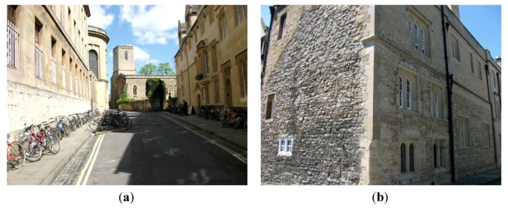
A preliminary photographic survey was executed on 12 May 2012, followed by a full photographic survey a couple of weeks later on 26 May 2012. These surveys were taken by the author around noon along Queen’s Lane in central Oxford, UK. Digital photographs obtained in both surveys will be considered here. This location was selected in the city centre because of its untouched appearance (retaining much of the integrity of the original stone-work, or authenticity), as cleaning and restoration have been mainly excluded here in this pedestrianised lane. A digital camera (FujiFilm J32 with 12.2 megapixels (M)) was used with flash off and macro on at 3M image resolution. Photographs were taken free-style (without a tripod) in order to capture features at different heights above street-level. Images were captured towards both sides of Queen’s Lane, covering buildings belonging to Queen’s, St Edmund Hall, New, and Hertford Colleges. These images were used to pictorially demonstrate weathering forms evident on historical limestone walls along this roadway from the High Street heading northwest to Catte Street. A pointer was included where possible (in closer-up images), measuring 2.2 cm along its (white) tip, for scale as well as potential for data quantification. Only photographs containing this scale point were classified due to size requirements; however, photographs were also taken at a distance to present some larger features. However, the pictorial approach is limited to micro- to mesoscale features.
Based on a conceptual model of stone soiling and decay, a new weathering tool was devised by the author. This was performed in order to represent weathering damage to historical limestone of visible features at the micro- to mesoscale (mm to m), after
Table 1 by McIlroy de la Rosa and colleagues [
19]; and borrowing somewhat from Viles’s [
20]
Table 1, which identified weathering pits (to occur at the µm to m scale) and scaling and blisters (at the mm to m scale). Unfortunately, her paper does not differentiate weathering processes from phenomena and mixes forms (fractures, rillenkarren, alveoli, tafoni, weathering pits, and scaling and blisters with processes, such as dissolution (from µm to km), salt weathering (possibly µm and m and certainly mm to cm), and biological weathering (µm to cm scale) as well as pressure release and deep weathering.
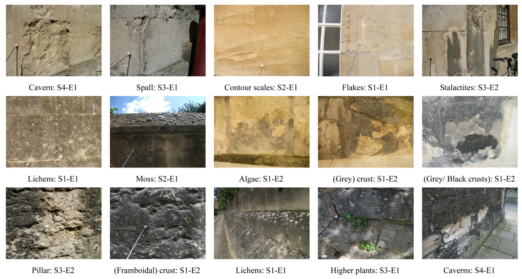
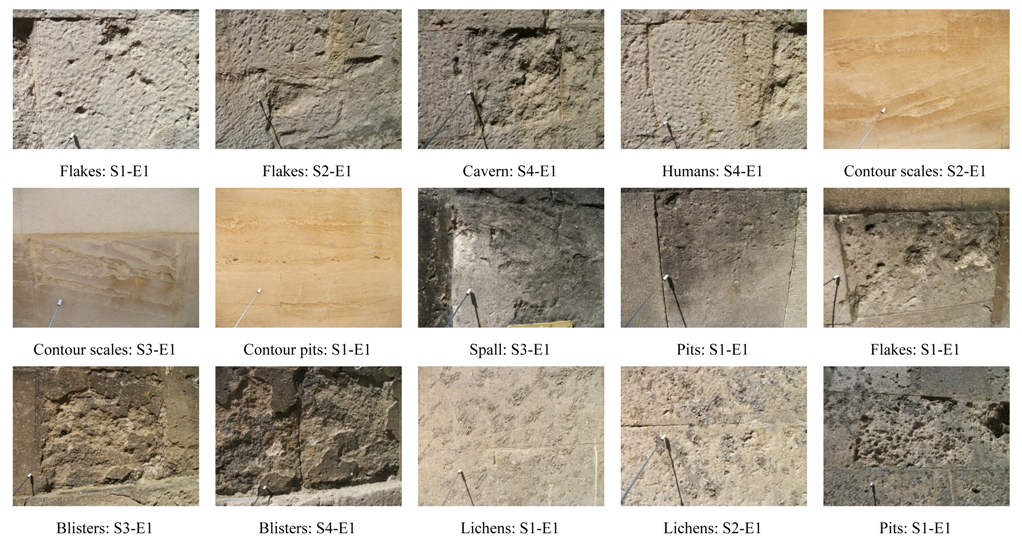
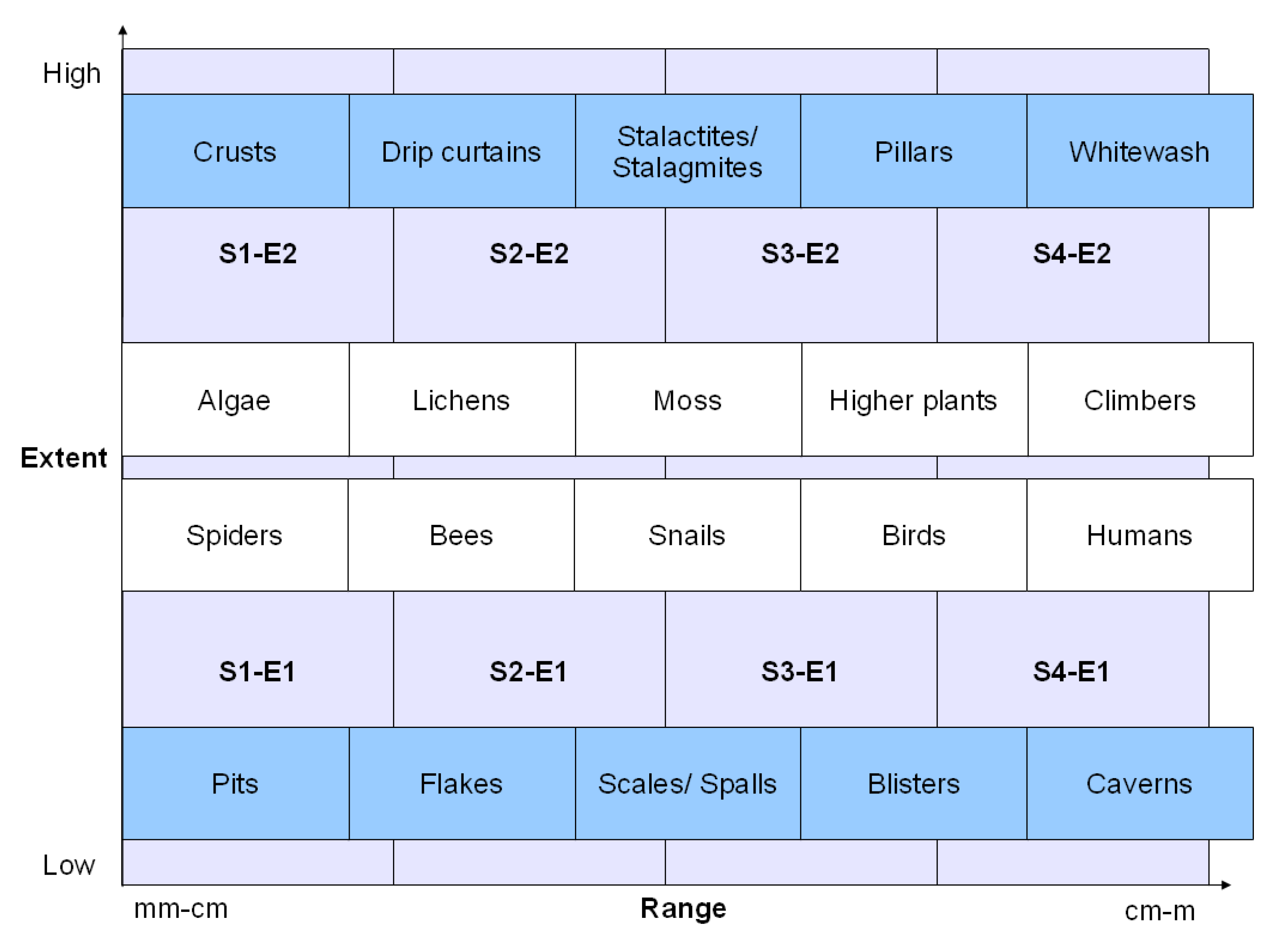
The weathering index derived from this approach, the S-E index, appears in
Figure 1 and comprises five decay features, including pits, flakes, scales, blisters, and caverns, that are low in extent at varying sizes (ranging from mm-cm to cm-m, or more specifically from 2 mm to 2 m). Soiling is considered to be high in extent and ranges from dark to light colouration (representing the deteriorative process of dissolution), encompassing crusts, drip curtains, stalactites/ stalagmites (depending on whether rain-washing and dissolution are occurring from above or below, respectively), pillars, and whitewash (when surfaces have been rain-washed back to their original colour). In either direction of extent and ranging upwards in size are biological colonizers, including algae, lichens, moss, higher plants, and climbers.
Figure 1.
Size-extent (S-E) index used in the classification of weathering forms.
Figure 1.
Size-extent (S-E) index used in the classification of weathering forms.
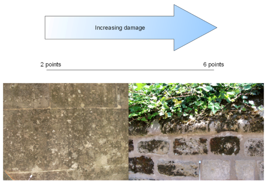
The classification scheme used is point-based (on a tiered five-point scale, with a possible score between two and six), including from small-sized at the microscale to larger-sized forms at the mesoscale (at a size of S1 through to S4); and extent at two levels of either low (E1) or high (E2). All weathering forms, including by flora and fauna, are classified according to this q classification system along each of two (x-y) axes of size and coverage (range-extent axes). Scores can be added, and range between two and six on a five-point scale (
Figure 2), where lower scores represent small discrete features that possibly appear only locally (with the lowest score being two) and the higher scores are for larger weathering forms that could also be extensive (highest score is six).
Figure 2.
Range of scores in this tiered five-point limestone weathering index.
Figure 2.
Range of scores in this tiered five-point limestone weathering index.
The instrument presented in this paper, namely the size-extent (S-E) index, only includes weathering phenomena, including decay (pitting, flaking, scaling, blistering, and contour scaling as well as cavernous weathering) and soiling (encrustation and soiling patterns adopted from karst landscapes, ranging to whitewashing). These encompass physical/ mechanical weathering as well as chemical weathering features. Biological weathering is considered through visible growths of algae, lichens, moss, and higher (vascular) plants, including climbing plants or climbers (ivy and creeper). These forms of weathering are conveyed according to size (within the micro- to mesoscale), ranging from mm to m, and extent, as demonstrative of their spatial coverage.
For instance, whereas discrete decay features could be intensive and ubiquitous, they are not usually extensive in cover. Conversely, soiling tends to be extensive, unless rain-washing has occurred for the development of soiling patterns, which have been considered as karstic features (normally associated with caves, borrowed from karst terminology for a unique application), such as drip curtains, stalactites and stalagmites (depending on whether rain-washing is from above or below), columns or pillars of rain-washing (as along drainpipes), and entirely whitewashed surfaces (where crusts have been cleaned and surfaces appear either crust-free or there is a clean white crust). Both soiling and decay are considered to be parts of the weathering system, but differ in extent. Plants and animals are independent variables (appearing alongside soiling and decay) because they contribute to bioweathering. This classification scheme is based on different types of weathering [
21], including physical (most decay features and soiling associated with encrustation), chemical (involving corrosive processes), and biological (of algae, lichens, mosses, and vascular plants). It has been developed from previous photographic surveys [
22,
23,
24,
25]. More recently, ICOMOS [
26] devised an 86-page glossary of stone deterioration patterns that takes a similar (pictorial) approach to the classification of common weathering forms and constitutes another tool for scientific discussions of decay phenomena and processes. This publication requires weathering knowledge that is not within an easy grasp of nonexperts. The introduced weathering index provides a more concise classification scheme that can be employed in cross-disciplinary research (by nonexperts).
3. Results and Discussion
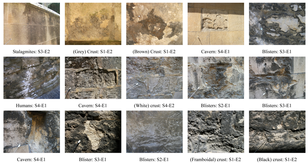
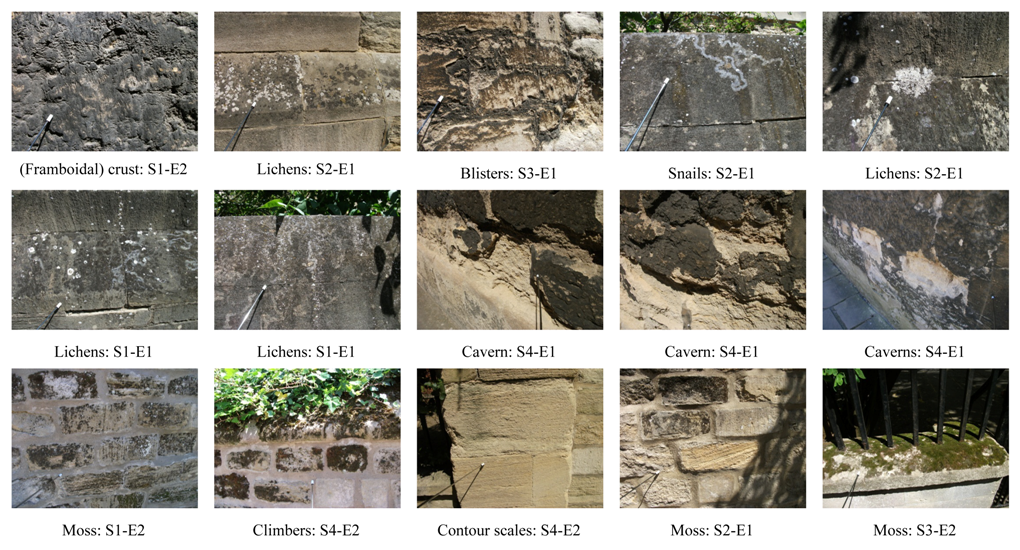
The derivative weathering instrument, the S-E index, applied to an exemplary photographic survey along Queen’s Lane in the Oxford city centre produced up to 13 examples for each class. These images appear in the appendix at the end of this paper for the reconnaissance (Appendix A) and actual field study (Appendix B). A summary of these results appears in
Table 1. A total of 60 images were classified using the S-E index. Most weathering forms in the study area were low in extent (45 out of 60, or 75%). There was a range of sizes represented more or less evenly distributed across size classes, with a slightly greater abundance of small features (S1). It was not possible to perform statistical analysis (a χ
2 test) because one cell (namely, S2-E2) had a zero score. However, the most abundant size class was S2 at E1 and S1 for E2, representing smaller features.
Table 1.
Summary table of counts of weathering forms (N = 60).
Table 1.
Summary table of counts of weathering forms (N = 60).
| Size/Extent | E1 | E2 | Total |
|---|
| S1 | 3 + 8 = 11 | 2 + 6 = 8 | 19 |
| S2 | 4 + 9 = 13 | 0 | 13 |
| S3 | 2 + 7 = 9 | 2 + 2 = 4 | 13 |
| S4 | 2 + 10 = 12 | 0 + 3 = 3 | 15 |
| Total | 45 | 15 | 60 |
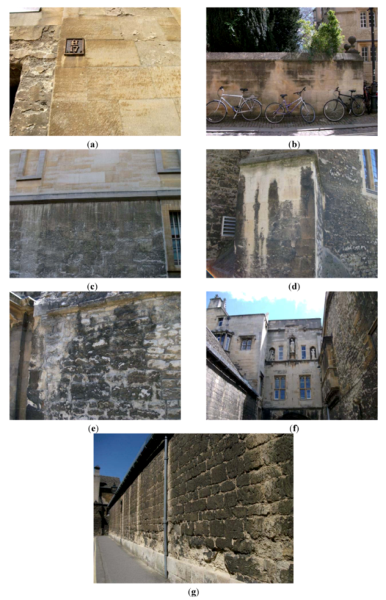
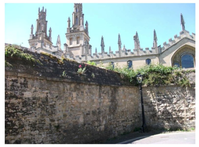
Because the stone-work at this location has remained largely intact over the years (devoid of cleaning and restoration different from college façades along major frontages) it has retained grown (mature) weathering forms, such as soiling (encrustation and discolouration). In addition to these grown features, vegetation has colonized the walls, with larger biological cover growing extensively (except for lichens and patches of moss). As exceptions, it is noteworthy to mention that building façades appear only somewhat cleaner towards High Street, especially evident at St. Edmund Hall, which was recently refronted, and at Hertford College towards the popular tourist route along Catte Street (
Figure 3). Nevertheless, even on such recently cleaned/ refaced stone-work, there is evidence of smaller decay features (pits, flakes, and scales). This effect is also evident elsewhere in central Oxford, for instance at the southern façade of the Ashmolean Museum, which was recently cleaned. Even though soiling is removed (and evidence of extensive forms of weathering cleared), smaller (decay) forms remain, including pits, flakes, and some scales on its plinth. Elsewhere, as along the boundary wall of Magdalen College along Longwall Street, cleaning led to cavernous weathering once surface crusts (binding and holding material together) were breached.
Figure 3.
Both sides of lane-way at the entry from High Street, showing (a) Queen’s College (left) and St Edmund Hall (right) as well as (b) behind Hertfort College from the lane-way.
Figure 3.
Both sides of lane-way at the entry from High Street, showing (a) Queen’s College (left) and St Edmund Hall (right) as well as (b) behind Hertfort College from the lane-way.
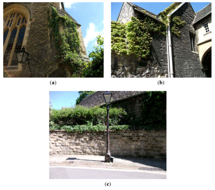
Along the Queen’s Lane, there are a myriad of weathering forms that range in both size (from the micro- to the mesoscale) and extent. The aesthetics of buildings are visibly affected by soiling, which has a large extent. However, as one examines the rock fabric more closely (and sometimes even at a distance), decay features can be seen at various sizes within the micro- to mesoscale. The weathering impacts of plants are also masked (covered) by their forms across rock surfaces. Climbing plants, in particular, drape stems and foliage across surfaces, concealing their impacts on the stone-work (
Figure 4). Vegetation grows naturally from rock surfaces once mossy surfaces develop some organic content on rock surfaces, and this is evident towards the top of old walls (
Figure 5). Architectural features also impact rainwater drainage from buildings, leading to the growth of algal mats in some areas (
Figure 6). In addition to this biofouling, there are also faunal impacts, including human impacts (
Figure 7).
Figure 4.
Climbing plants (climbers) along the lane, including (a) ivy at St Edmund Hall; (b) creeper in the grounds of Queen’s College and (c) ivy at New College.
Figure 4.
Climbing plants (climbers) along the lane, including (a) ivy at St Edmund Hall; (b) creeper in the grounds of Queen’s College and (c) ivy at New College.
Figure 5.
Vegetation colonizing the top of old walls at the Queen’s College grounds.
Figure 5.
Vegetation colonizing the top of old walls at the Queen’s College grounds.
Figure 6.
Algal mats growing at similar architectural features on buildings, at (a) St Edmund Hall and (b) near Queen’s College.
Figure 6.
Algal mats growing at similar architectural features on buildings, at (a) St Edmund Hall and (b) near Queen’s College.
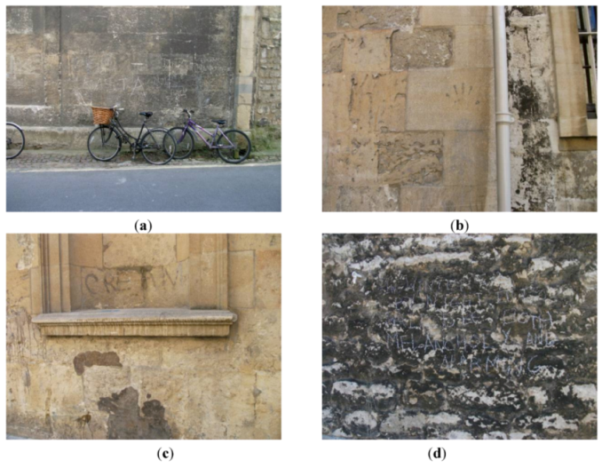
Figure 7.
Evidence of human impacts on stone-work, including various examples of graffiti (a–d).
Figure 7.
Evidence of human impacts on stone-work, including various examples of graffiti (a–d).
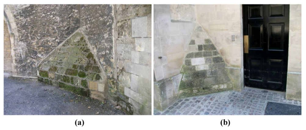
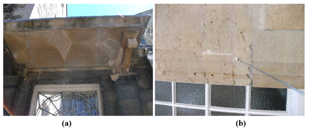
Scale in this study was limited to the micro- to mesoscale (mm-m), excluding any larger (or smaller) features. It was only possible to capture some features within reach of the pointer, so some larger features were excluded from the classification (
Figure 8). This has affected extent judgements, such as extensive blistering (
Figure 9a) and lichen cover (
Figure 9b). Larger weathering forms are more easily apparent. For instance,
Figure 3b shows the back of a building pertaining to Hertford College near Oxford’s Bridge of Sighs. A brown crust once covered the surface of the building (on the left side), probably forming through leached (metallic) elements migrating towards the surface (including iron). Remnants of this crust are still visible towards the top (left) of the building façade; nevertheless, much of it has come off and left exposed blocks of now darkened stone-work. Other triggers for weathering forms are largely linked with salt weathering, which is easily evident in the city centre (e.g.,
Figure 10a), as with cavernous weathering, since capillary rise brings up ground salts dissolved in water. The liquid enters into stone-work from the ground up and with the expansion of salts materials crack and fracture (burst out), as with caverns. Smith and colleagues [
27] likewise observed the rapid retreat of surfaces after contour scaling in a polluted maritime environment (Belfast), and mentioned multiple flaking and granular disaggregation after scaling of gypsum crusts evident on the Parliament Building (Budapest). The current study considers granular disintegration to be a process that leads to the development of forms, such as standing relief (through rock deflation and armouring) and caverns (
Table 2). Smith and colleagues [
28] recently found multiple flaking to occur at the mm-scale, with the potential controlling mechanism to be diurnal patterns of heating and cooling, which could also be used to account for phenomena like large-scale contour scaling. There are also natural points of weakness in these limestone blocks, such as along bedding planes, that are susceptible to contour decay (such as blistering and scaling). Spalling occurs at Queen’s College due to metal cramps (holders or brackets) that were embedded into buildings in order to hold the stone ashlar in place. With expansion (due to heating), these metal supports crack and fracture stone-work through the process of spalling, including visible flaking (smaller features) and scaling as well as actual spalls.
Figure 8.
(a) Brown crust; (b) stalagmite; (c) drip curtain; (d) and (e) stalactites; (f) whitewashing and (g) pillars.
Figure 8.
(a) Brown crust; (b) stalagmite; (c) drip curtain; (d) and (e) stalactites; (f) whitewashing and (g) pillars.
Figure 9.
Scale-sensitive extending features, including (a) blisters and (b) lichens.
Figure 9.
Scale-sensitive extending features, including (a) blisters and (b) lichens.
Figure 10.
Evidence of (a) salt weathering through efflorescence and (b) complexity of the weathering situation (complex representation), including pitting, flaking, and human intervention.
Figure 10.
Evidence of (a) salt weathering through efflorescence and (b) complexity of the weathering situation (complex representation), including pitting, flaking, and human intervention.
Table 2.
Causation typical of a selection of weathering forms.
Table 2.
Causation typical of a selection of weathering forms.
| Weathering form | Causation | Processes |
|---|
| Pits | Acidity; expanded by insects | Dissolution |
| Flakes | Derivatives of cracks and pressure release | Granular disintegration |
| Scales/Spalls | Larger features of pressure release, including contour scaling | Granular disintegration; spalling |
| Blisters | Thermal expansion and bursting (rupture) of crusts | Exfoliation |
| Caverns | Expanding salts and breached crusts, including standing relief | Granular disintegration |
| Crusts | Chemical reactions with acids, such as sulphur; leaching and precipitates | Case hardening |
| Drip curtains | Rain-washing action leading to whitewashing along drip-lines | Dissolution |
| Stalactites/ Stalagmites | Rain-washing action leading to whitewashing of vertical surfaces | Dissolution |
| Pillars | Rain-washing action leading to whitewashing of larger surfaces, leading to pillars | Dissolution |
| Whitewash | Rain-washed surfaces | Dissolution |
Caveats
It is noteworthy that this classification scheme is not perfect. For instance, some decay features are excluded from this sample. Moreover, in some cases too many forms are captured in a single photograph (e.g.,
Figure 10b, which conveys, pitting, flaking, and human impacts). The main point here is to convey the classification system and make a contribution to its application in order to work towards developing it. Scale is always difficult when constructing classification schemes, and a serious attempt has been made here to consider size at the micro- to mesoscale. However, a valid criticism is that weathering forms appearing at other scales, as at the nano and macroscale, are missing. The reason for this is that an emphasis was chosen for visible features (from the mm to m scale) so that nonexperts could incorporate this weathering instrument, the S-E index, into their assessments and thereby participate in its deployment. Even for Oxford, it is possible that this roadway does not convey all possible features. In some cases, it is also possible that the size of forms could lead to overlapping features, such as potentially flakes/scales and blisters. This potential is also recognised by other authors, such as [
20], who considered scaling and blistering together (between mm and m scale). The S-E index is form-dependent rather than process-dependent and the mechanisms of weathering are considered separately and not in the actual classification.
This instrument as deployed here is not quantitative (but qualitative) due to the exclusion of all features, both at the small (perhaps the most important exclusion) and large scale, and the lack of specific measurements of weathering forms. The advantage of this nonquantitative application is that it is easier to use, as by novices in cross-disciplinary research. Photographs are particularly user-friendly and capture a variety of weathering forms, especially at the mesoscale. It is possible to derive quantitative data from photographs, as conveyed in various studies, e.g., [
29,
30,
31]. However, qualitative interpretations could lead to suppositions in the analysis, especially where there is uncertain or missing information about weathering forms. Having a photo-based index has been developed by other authors, for instance ICOMOS-ISCS, which could have been used in this assessment. The S-E index is a more concise instrument and easier to be applied by nonexperts. Furthermore, it is possible to acquire actual data measurements for size and extent based on image processing, which will be endeavoured by the author in a subsequent publication.
Lastly, there is the element of error associated with the interpretation of weathering systems and their forms, although this could affect any technique involving a visual (qualitative) assessment. Although this was originally intended to be a purely quantitative weathering scale, such visual assessments are qualitative. This could affect size-based classifications and could lead to disagreements and even disputes about what constitutes a weathering form. It is also currently under debate whether vegetation plays a protective or deteriorative role; this uncertainty extends to any associations of weathering with a plant-cover. Perhaps it is best for vegetation to be considered separately as (biological) growths rather than specific weathering features; however, biological weathering is one of the three main types of weathering and so it has been treated (as a weathering type) similarly in this paper. The S-E index is to be applied for the assessment of weathering forms appearing specifically on limestone. Further research is needed to determine whether it is valid for use on other stone types, such as sandstone. It would also be relevant to consider the geological history and construction time of the walls, this varies for the different Oxford colleges. For instance, St Edmund Hall was founded first in 1317, followed by Queen’s College founded in 1341 (as the Hall of the Queen’s Scholars of Oxford), then New College in 1379, and the present Hertford College was established last in 1874. These dates are only indicative, since they represent the time of the founding of the various colleges surrounding the lane-way. Overall, however, the stone-work may be as early as 14th century and there appears to be only minor repairs executed near the High Street frontage.
It is important to note here that this weathering tool is for use on limestone and it is questionable how applicable it is to other types of stone as well as noncultural stone. For instance, Sweeting and Lancaster [
32] referred to granular disintegration of rocks in the central Namib Desert. Finally, inheritance effects cannot be accounted for here, even though Török and colleagues [
33] implicated the influence of the past, as with the appearance of lead in dust and the soiled zone of the built environment even after leaded petrol was banned. Thornbush [
34] similarly discovered higher concentrations of lead on crusts (74.03 ppm) than on blisters (51.74 ppm) in comparison to a control site (11.65 ppm). Such accumulations from past contaminants could still be affecting the formation of some decay features on stone-work, particularly as surfaces have generally not been cleaned along Queen’s Lane.
This classification system considers separate classes of soiling (mainly chemical weathering) and decay (chemical and some physical weathering) as well as the potential for vegetation and animals (including humans) to damage historical limestone (through biological weathering). It allows for the classification of bioweathering forms as either chemical or physical weathering forms. By considering soiling separately, it is possible to classify soiling patterns (extensive) separately and in addition to decay. The classification for this has comprised of initial surface soiling through exposure to carbonic acid (in rainwater) in the carbonation process, encrustations (in this case, grey and black or brown), ranging to drip curtains, stalactites and stalagmites (depending on direction of dissolution), as well as entire pillars, to whitewashed surfaces at the furthest extent of a size-based determination (for dissolution features). Terminology has been borrowed from karst landscapes and originally adopted here to convey soiling patterns derived from dissolution. Developing a site-specific classification system is challenging because of its nature and limited broader applicability. However, the intention here is to tailor the index to sites so that the results are indeed specific to different study areas and the weathering forms found there. A tailored approach is limited, but justifiable, since weathering forms are environment-dependent (and not just dependent on the fabric and temporal considerations). Microclimate, for instance, varies according to location and this is true also for pollution regime and other environmental factors.
4. Conclusions
It is possible to devise site-specific weathering classification systems (instruments) for historical monuments comprising cultural stone. In this case, Queen’s Lane in central Oxford was selected for a photographic survey of weathering forms visibly apparent on limestone walls in a part of the city that has not experienced extensive cleaning and restorative works. It is evident, that along major roadways with much pedestrianisation, such as the High Street, there are more attempts to maintaining clean, unblemished (presentable) stone-work. Gratefully, this portion of the city centre, has been pedestrianised and retains much of its original stone-work. For this reason, it presents an ideal site for the development of a weathering index for use in the classification of weathering forms found on historical buildings comprised of limestone.
In a photographic survey, it was possible to portray a variety of soiling (degradation) and decay (deterioration) features, representing a range of sizes and extent. For surfaces with a low extent of decay forms, pits, flakes, scales, blisters, and caverns were identified; and for a high extent soiling forms included surface alteration by crusts (of different colours), drip curtains, stalactites/ stalagmites, pillars, and whitewash were visible. These features could be developed by vegetation, including algae, lichens, mosses, small plants, and higher plants, such as climbers. Respective weathering forms were identified at the micro- to mesoscale and classified according to the S-E index.
Using this approach, it has been possible to produce a linear assessment tool of weathering for limestone. The instrument scale allows for a range of weathering forms to be classified, but is specific to those features apparent along this roadway (as it is site-specific). However, the classification system can be applied at other locations to constitute other weathering forms that are site-specific. In this way, the tool is versatile, as it can be easily adopted and can be representative of weathering damage in a variety of climatic regions, representing different environments. The S-E index has been derived from the perspective of classic geomorphological concepts, considering physical (or mechanical), chemical, and biological weathering (bioweathering). This is a unique approach in the currently published literature for weathering classification systems, which have depended on the additive (depositional) or subtractive (erosional) nature of weathering forms. By linking features with triggers (even tentatively, where there is missing support in the published literature), it is possible to arrive at some sense of causation. This approach is productive because of its cause-effect connection, which provides a practical foundation for conservation measures and policy-setting.


