
When the Crime Scene Is the Road: Forensic Geoscience Indicators Applied to Road Infrastructure and Urban Greening


Abstract
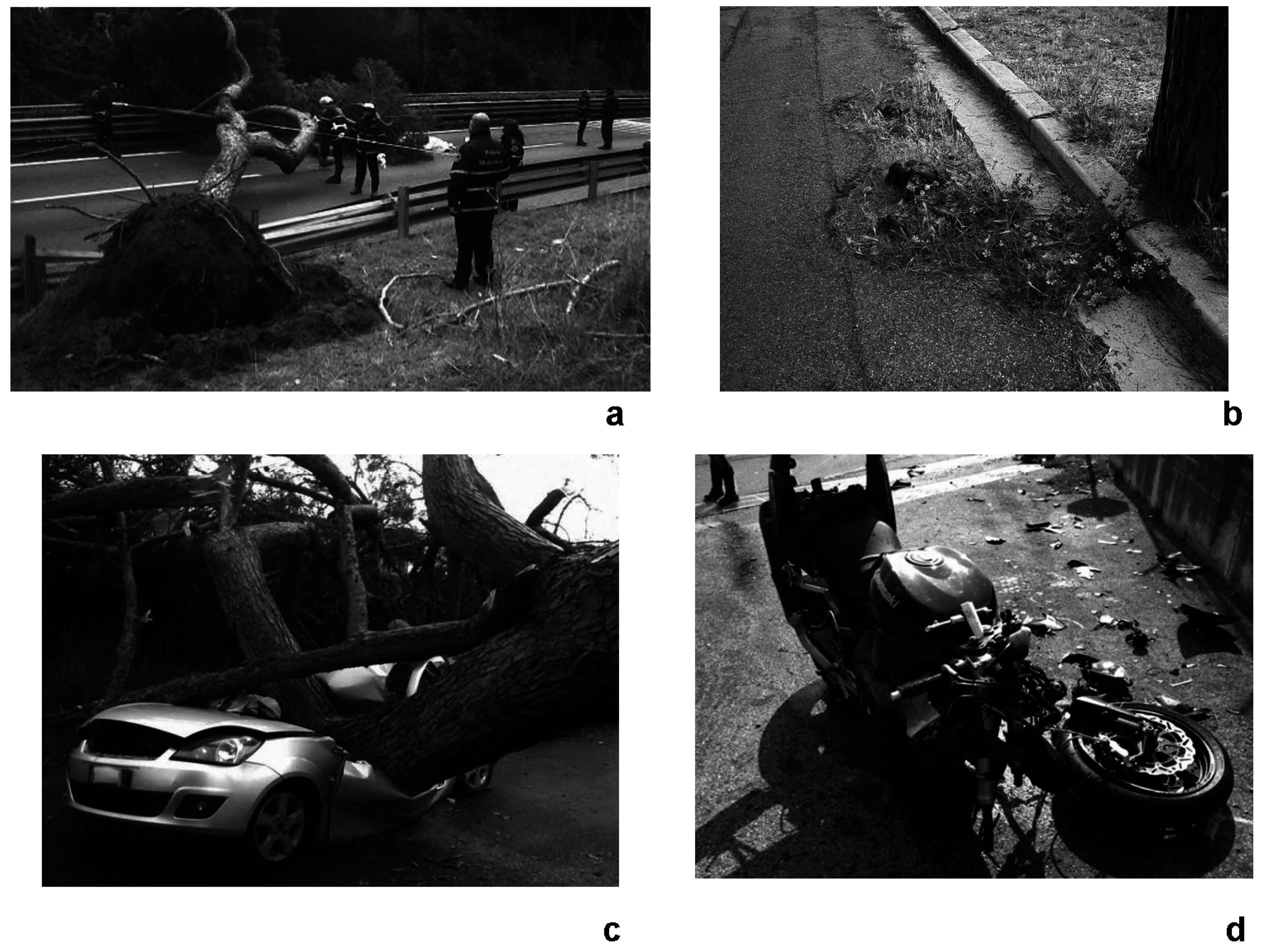
:1. Introduction
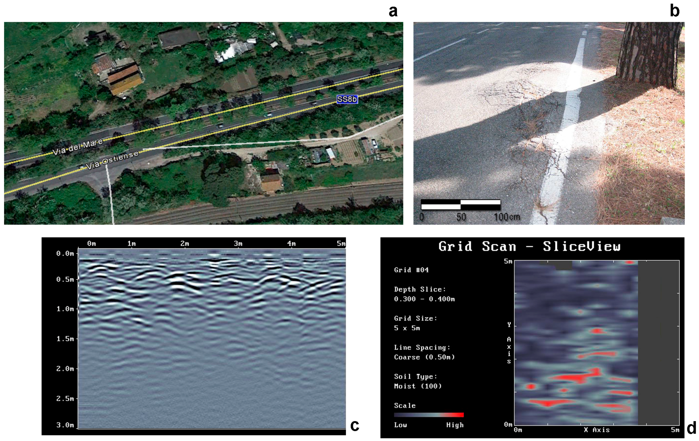
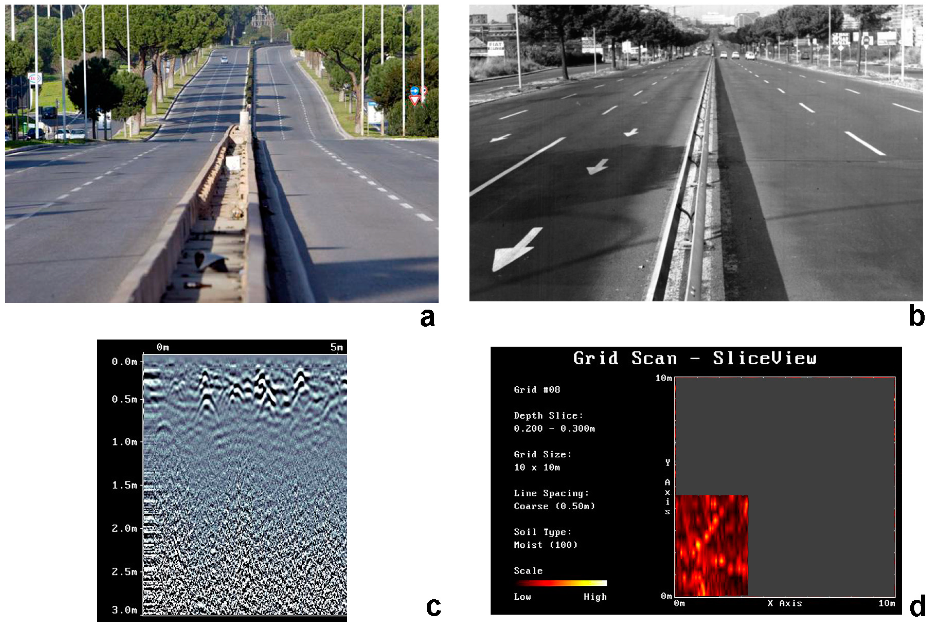
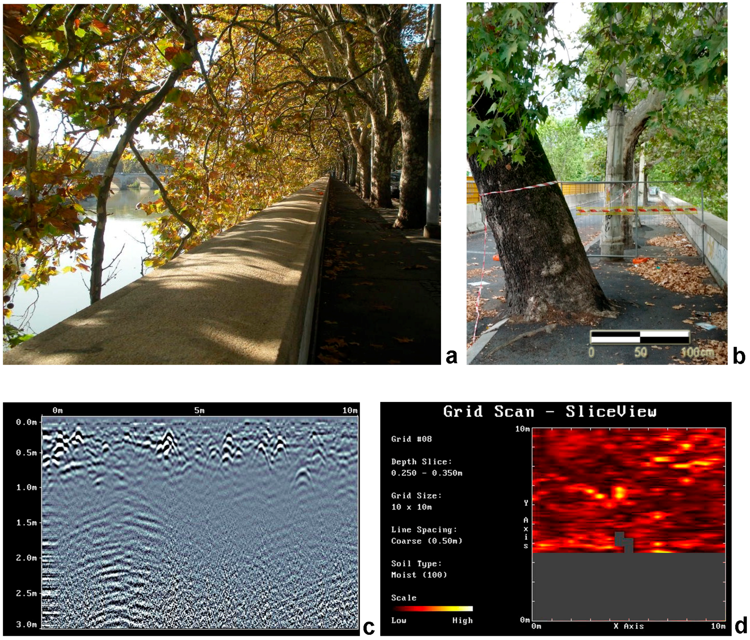
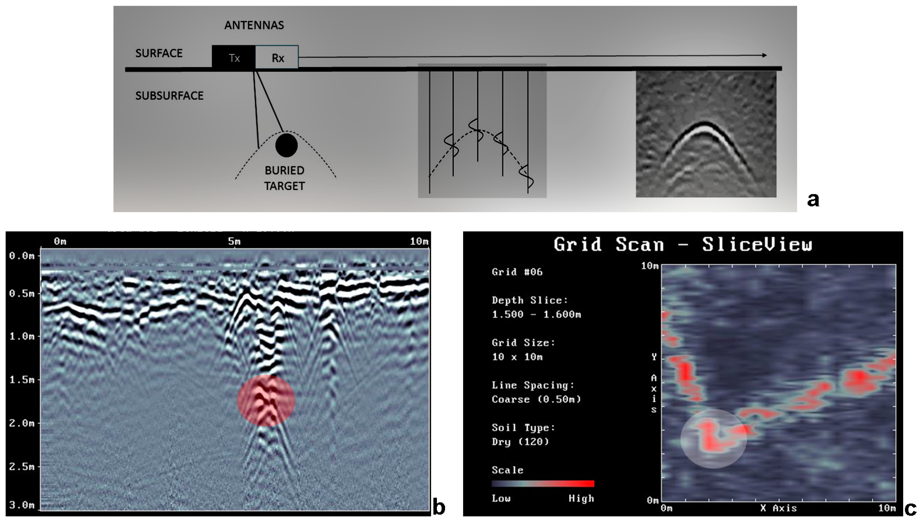
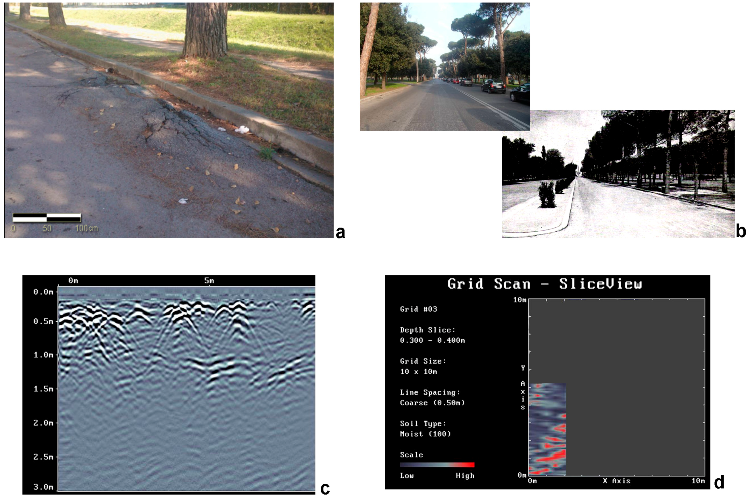
2. Materials and Methods
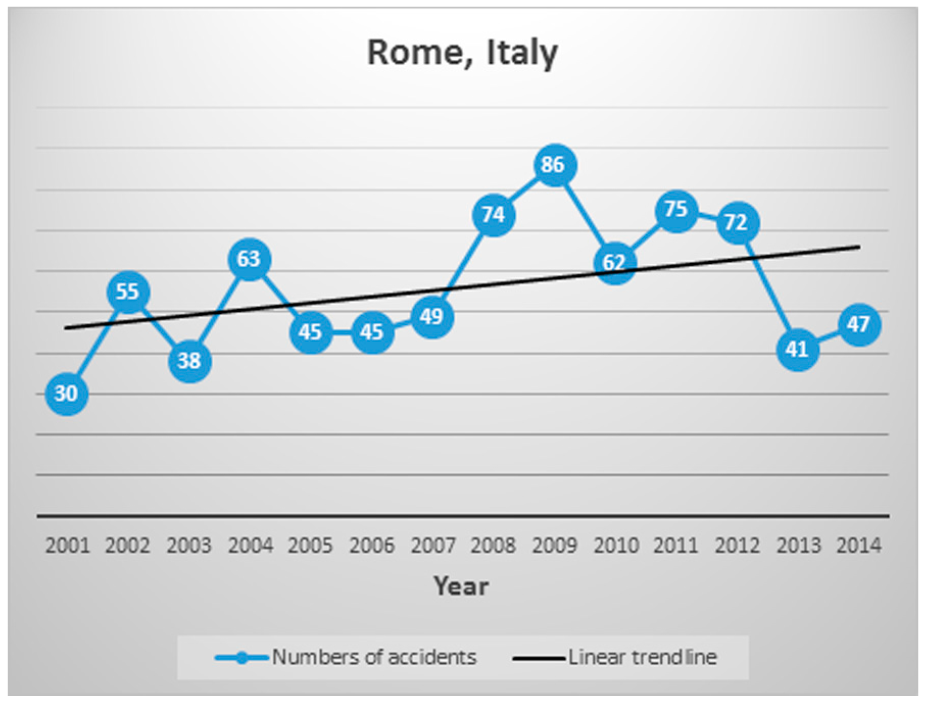
3. Results and Discussion
4. Conclusions
Acknowledgments
Author Contributions
Conflicts of Interest
References
- Wagar, J.A.; Barker, P.A. Tree root damage to sidewalks and curbs. J. Arboric. 1983, 9, 177–181. [Google Scholar]
- Wagar, J.A. Reducing surface rooting of trees with control planters and wells. J. Arboric. 1985, 11, 165–171. [Google Scholar]
- Barker, P.A.; Peper, P. Strategies to prevent damage to sidewalks by tree roots. J. Arboric. 1995, 19, 295–309. [Google Scholar] [CrossRef]
- Costello, L.R.; Elmore, C.L.; Steinmaus, S. Tree root response to circling root barriers. J. Arboric. 1997, 23, 211–218. [Google Scholar]
- Gilman, E.F. Root barriers affect root distribution. J. Arboric. 1996, 22, 151–154. [Google Scholar]
- Gilman, E.F. Deflecting roots near sidewalks. Arboric. Urban For. 2006, 32, 18–22. [Google Scholar]
- Grabosky, J.; Bassuk, N. Testing of structural urban tree soil materials for use under pavement to increase street tree rooting volumes. J. Arboric. 1996, 21, 197–201. [Google Scholar]
- Kopinga, J. Aspect of the damage to asphalt road paving caused by tree roots. In The Landscape below Ground; Watson, G.W., Neely, D., Eds.; International Society of Arboriculture: Champaign, IL, USA, 1994. [Google Scholar]
- Smiley, E.T.; Calfee, L.; Fraedrich, B.R.; Smiley, E.J. Comparison of structural and noncompacted soils for trees surrounded by pavement. Arboric. Urban For. 2006, 32, 164–169. [Google Scholar]
- Scholtz, T.V.; Brown, S.F. Factors affecting the durability of bituminous paving mixtures. In Performance and Durability of Bituminous Materials; Cabrera, J.G., Dixon, J.R., Eds.; E & FN Spon: London, UK, 1996; pp. 173–190. [Google Scholar]
- Smiley, E.T. Comparison of Methods to Reduce Sidewalk Damage from Tree Roots. Arboric. Urban For. 2008, 34, 179–183. [Google Scholar]
- Trowbridge, P.; Bassuk, N.L. Trees in the Urban Landscape: Site Assessment, Design and Installation; Wiley and Sons, Inc.: Hoboken, NJ, USA, 2004. [Google Scholar]
- McPherson, E.G.; Muchnick, J. Effects of street tree shade on asphalt concrete pavement performance. J. Arboric. 2005, 31, 303–310. [Google Scholar]
- Appleton, B.; Horsley, J.; Harris, V.; Eaton, G.; Fox, L.; Orband, J.; Hoysa, C. Trees for Parking Lots and Paved Areas. In Virginia Cooperative Extension; Publication 430-028; Virginia Polytechnic Institute and State University: Blacksburg, VA, USA, 2009. [Google Scholar]
- D’Amato, N.E.; Sydnor, T.D.; Knee, M.; Hunt, R.; Bishop, B. Which comes first, the root or the crack? J. Arboric. 2002, 28, 277–289. [Google Scholar]
- Kjelgren, R.; Montague, T. Urban tree transpiration over turf and asphalt surfaces. Atmos. Environ. 1998, 32, 35–41. [Google Scholar] [CrossRef]
- Costello, L.R.; Jones, K.S. Reducing Infrastructure Damage by Tree Roots: A Compendium of Strategies; International Society of Arboriculture: Cohasset, CA, USA, 2003. [Google Scholar]
- McPherson, E.G.; Peper, P. Infrastructure repair costs associated with street trees in 15 cities. In Proceedings of an International Workshop on Trees and Buildings; Watson, G.W., Neely, D., Eds.; International Society of Arboriculture: Champaign, IL, USA, 1995. [Google Scholar]
- McPherson, E.G. Expenditures associated with conflicts between street trees root growth and hardscape in California. J. Arboric. 2000, 26, 289–297. [Google Scholar]
- Bailey, L.S. 1891 Lambert a New Claim for America’s First Gasoline Automobile. Antiq. Automob. 1960, 24, 340–400. [Google Scholar]
- Eckermann, E. World History of the Automobile; Society of Automotive Engineers: Warrendale, PA, USA, 2001. [Google Scholar]
- Italian National Institute of Statistics. Incidenti stradali. In Annuario Statistico Italiano 2015; ISTAT: Rome, Italy, 2015. [Google Scholar]
- Roma Capitale. L’incidentalità a Roma. 2015. Available online: https://www.comune.roma.it/PCR/resources/cms/documents/L_incidentalita_a_Roma_X.pdf (accessed on 4 November 2016). (In Italian)
- Barone, P.M.; Di Maggio, R.M.; Ferrara, C. Forensic Geoscience during CS Investigations and Courtroom Trials without a Murder. J. Forensic Sci. Criminol. 2016, 4, 302. [Google Scholar]
- Barone, P.M.; Di Maggio, R.M.; Ferrara, C. Not necessarily buried bodies: Forensic GPR investigations from criminal to civil justice. In Proceedings of the 8th IEEE International Workshop on Advanced Ground Penetrating Radar (IWAGPR), Florence, Italy, 7–10 July 2015.
- Ruffell, A.; McKinley, J. Geoforensics; John Wiley & Sons, Ltd.: Hoboken, NJ, USA, 2008. [Google Scholar]
- Daniels, D.J. Ground-Penetrating Radar, 2nd ed.; IEE Radar, Sonar, Navigation and Avionic Series 15; The Institution of Engineering and Technology: London, UK, 2004. [Google Scholar]
- Persico, R. Introduction to Ground Penetrating Radar: Inverse Scattering and Data Processing; Wiley-IEEE Press: Hoboken NJ, USA, 2014. [Google Scholar]
- Annan, A.P. Ground Penetrating Radar: Principles, Procedures & Applications; Sensors & Software, Inc.: Mississauga, ON, Canada, 2004. [Google Scholar]
- Jol, H. Ground Penetrating Radar Theory and Applications; Elsevier: Amsterdam, The Netherlands, 2009. [Google Scholar]
- Barone, P.M. Understanding Buried Anomalies: A Practical Guide to GPR; LAP Lambert Academic Publishers: Saarbrücken, Germany, 2016. [Google Scholar]
- Ferrara, C.; Barone, P.M.; Pettinelli, E.; Salvati, L. Ground Penetrating Radar as a remote-sensing approach to investigate the root system architecture beneath the soil. Appl. Ecol. Environ. Res. 2014, 12, 695–702. [Google Scholar] [CrossRef]
- Painter, B.W. Rome: Rebuilding the Eternal City; Palgrave MacMillan: London, UK, 2005. [Google Scholar]


© 2016 by the authors; licensee MDPI, Basel, Switzerland. This article is an open access article distributed under the terms and conditions of the Creative Commons Attribution (CC-BY) license (http://creativecommons.org/licenses/by/4.0/).
Share and Cite
Barone, P.M.; Ferrara, C.; Di Maggio, R.M.; Salvati, L. When the Crime Scene Is the Road: Forensic Geoscience Indicators Applied to Road Infrastructure and Urban Greening. Geosciences 2016, 6, 50. https://doi.org/10.3390/geosciences6040050
Barone PM, Ferrara C, Di Maggio RM, Salvati L. When the Crime Scene Is the Road: Forensic Geoscience Indicators Applied to Road Infrastructure and Urban Greening. Geosciences. 2016; 6(4):50. https://doi.org/10.3390/geosciences6040050
Chicago/Turabian StyleBarone, Pier Matteo, Carlotta Ferrara, Rosa Maria Di Maggio, and Luca Salvati. 2016. "When the Crime Scene Is the Road: Forensic Geoscience Indicators Applied to Road Infrastructure and Urban Greening" Geosciences 6, no. 4: 50. https://doi.org/10.3390/geosciences6040050