1. Introduction
River ice thawing and breakup is an annual springtime phenomenon in the Arctic. Depending on regional weather patterns and river morphology, breakup can result in floods [
1]. Breakup floods often cause catastrophic ice and water damage to expose and vulnerable riverine communities, and lead to socioeconomic and ecological crisis [
2]. Floods commonly originate upstream from ice jams—accumulations of chunks and sheets of ice in the river channel, that block or restrict stream flow during spring melting. Ice jams form anywhere in a river channel where an ice run (i.e., the rapid breaking up or fragmentation of river ice) comes in contact with an intact and resistant ice cover [
3]. Ice jams most frequently form where the channel gradient suddenly drops, for example at islands (in multichannel reaches) or in the first bend following a long linear reach. Once formed, ice jams produce rise of water levels of meters per hour and can hold for days, forcing melt water and ice floes to back up for kilometers, causing flooding upstream. The sudden release of an ice jam and the resulting ice run can also generate flash flooding downstream and cause additional damage by rapid withdrawal of water from flooded areas.
Spring flood risk is especially high in rural and remote communities, where flood relief and recovery are complicated by limited physical and communication infrastructure in addition to the region’s unique geographical and climatological features. In this study, the concept of risk is expressed as the likelihood of fatalities, injuries, and destruction from an ice-jam flood during springtime river ice breakup and melting. Furthermore, flood risk results as the consequence of the interaction between a hazard (i.e., ice-jam flood), and the characteristics that make communities vulnerable and exposed. Via a comparative case study, we identified natural processes that generate conditions of hazard, and human activities that generate conditions of exposure and vulnerability.
Many definitions and interpretations of hazard, exposure, and vulnerability exist in academic and professional literature. In the context of this study, a hazard is an ice-jam flood—a natural phenomenon that may cause death, injury or other health impacts, property and infrastructure destruction or damage, social and economic disruption, and environmental degradation. Exposure refers to the presence and number of people, as well as their resources and assets in flood-prone locations. The concept of vulnerability represents the economic, environmental, political, physical, and social characteristics and circumstances of a community that make it susceptible to the adverse impacts of an ice-jam flood.
Via this comparative case study, we also analyzed complex interaction between hazard, exposure, and vulnerability conditions that result in the annual flood risk in the rural US and Russian Arctic. A thorough understanding of flood risk allowed us to evaluate the effectiveness of the existing flood risk reduction practices in both regions. In the context of this study, flood risk reduction encompasses the development, application, and evaluation of policies, strategies, and practices to reduce or eliminate adverse flood impacts in at-risk communities. It falls into three main pre-flood phases: prevention, mitigation, and preparedness.
2. Research Sites
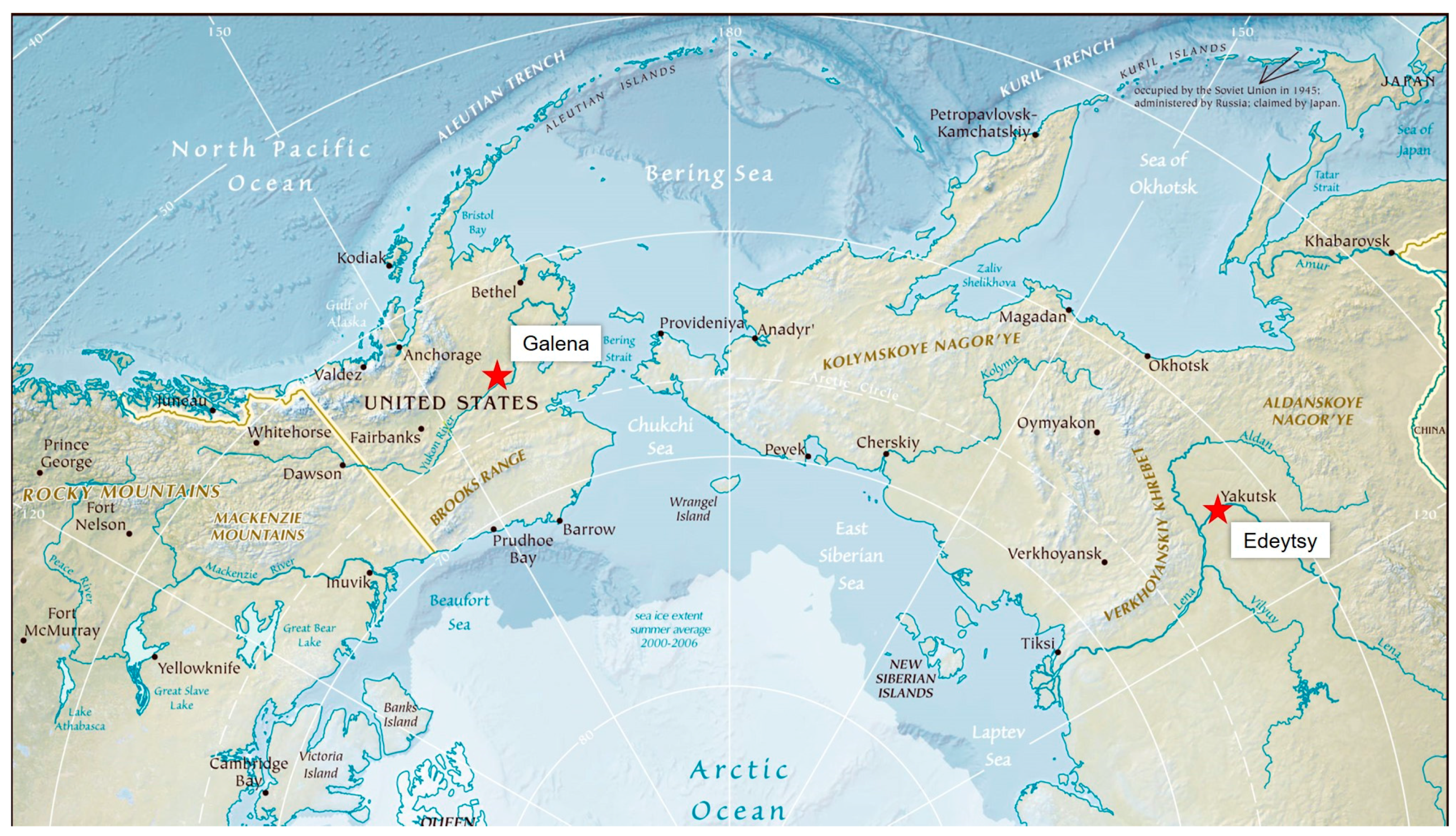
Two flood-prone rural communities—Galena, situated on the Yukon River in Interior Alaska, United States and Edeytsy, situated on the Lena River in the Central Yakutia (Sakha Republic), Russia—were selected for the comparative case study analysis (
Figure 1). Comparative parameters included natural and human causes of spring floods, effectiveness of spring flood risk reduction efforts, and the role of interagency communication and cooperation in flood risk reduction (
Table 1).
Galena is a remote community of 467 people, located in traditional Koyukon Athabascan Indian territory in central Alaska [
4]. It is situated on the northern bank of the Yukon River, over 430 km away from the nearest urban center in Fairbanks, and 1600 km from the state’s capital, Juneau. The community can be reliably accessed only via aircraft year around, snowmobiles in the winter, and boats and barges in the summer. Galena’s remoteness significantly challenges and delays flood response and recovery.
Edeytsy is a rural community of 1261 people, located in central Yakutia, Northeast Siberia. Unlike Galena, Edeytsy can be reliably accessed year-round via road. The community is situated on the eastern bank of the Lena River, only 35 km from the regional center Namtsy, and 60 km from the Republic’s capital of Yakutsk. Edeytsy’s accessibility facilitates timely flood response and recovery.
Within a week of each other in May 2013, Galena and Edeytsy sustained major ice-jam floods. In both communities, floodwaters and ice floes destroyed or severely damaged over 90 percent of homes and key infrastructure, resulting in multimillion-dollar damage [
5,
6]. Although extreme, the 2013 floods were not isolated instances in either community. Galena faced two major spring floods in May 1971 (the largest flood to date) and May 1963, while Edeytsy’s previous large flood was in May 2010. Prior to 2013, Galena experienced overall 11 incidents of spring flooding (1966, 1971, 1972, 1977, 1984, 1989, 1991, 1992, 1994, 2000, and 2001), and Edeytsy—eight incidents (1968, 1978, 1997, 2007, 2009, 2010, 2011, and 2012), in the last 50 years. The flood years were indicated by the survey respondents and cross-referenced with the flood records from the Alaska-Pacific River Forecast Center, the U.S. Army Corps of Engineers, and the Russian Federal Service for Hydrometeorology and Environmental Monitoring. To prevent losses and alleviate the impacts of ice-jam floods, a series of flood risk reduction efforts (e.g., partial relocation, building elevation, construction of dikes, and ice-jam demolition) have been implemented in Galena and Edeytsy with varying degrees of success. These efforts are exemplary of the efforts implemented throughout Alaska and Yakutia (and other US and Russian northern regions).Besides Galena and Edeytsy, multiple riverine communities in Alaska and Yakutia are exposed to spring floods due to their location. In Yakutia, 222 communities (approximately 630,000 people) out of 409 are located in floodplains and exposed to ice-jam floods. Ninety-five communities (43%) regularly experience spring floods. In Alaska, 45 communities (populations ranging between 40 and 500 people) out of 356 are exposed to spring floods. Furthermore, ice-jam floods regularly impact multiple northern regions besides Russia and the United States. Thus, emergency managers, policymakers, and communities at flood risk throughout high latitudes would find lessons from this study useful.
3. Background and Literature Review
This study responds to the need for disaster risk reduction to minimize the adverse impacts of catastrophic floods in rural northern communities during springtime river ice breakup. Taking its origin at the end of the twentieth century, disaster risk reduction is a relatively new concept in disaster research and management [
7,
8]. The underlying idea behind disaster risk reduction is to proactively manage disaster risk to minimize and ideally prevent its adverse impacts, as opposed to reacting to the disaster crisis.
The potential benefits of a more proactive disaster management approach are especially evident in high latitudes, where brutal weather, vast distances, limited infrastructure, and seasonal lack of daylight pose significant obstacles to emergency response [
9]. Inadequate risk assessment and emergency training further complicate disaster response in many parts of the Arctic [
10]. Major emergency responses (i.e., national disaster responses) are launched from the southern hubs in lower latitudes, which are relatively long distances away from the impacted communities. Responders from the south are often unfamiliar with the geographic area, as well as the unique logistical and cultural features of the Arctic. Moreover, processes used to trigger federal assistance vary between jurisdictions, creating additional complications and delays in disaster relief [
11].
Furthermore, future climate prediction reports suggest there will be an increase in frequency and intensity of some climatological and hydrological disasters [
12,
13,
14]. Considering everything mentioned above, not investing in disaster risk reduction in the Arctic and continuing to rely predominantly on disaster response and crisis management will ultimately put many northern peoples and communities at risk.
Review of academic literature and professional reports in the fields of disaster risk reduction in the Arctic has revealed three main trends:
Disaster risk reduction research has been predominantly focused on megacities and urban areas, thus underrepresenting the risk in rural communities [
12,
15].
Disaster risk in the Arctic has been primarily concerned with coastal flooding and erosion [
10,
16], and oil spills [
10,
17]. The latest trend in circumpolar disaster research incorporates mishaps with tourist ships [
10,
11].
In most cases, disaster risk reduction in the Arctic is coupled with climate change adaptation [
13,
18,
19,
20]. This long-term perspective is crucial for the sustainable development of northern communities. However, it also neglects the immediate adverse impacts of disasters that are happening now.
This study contributes to the existing research in the fields of disaster risk reduction and disaster risk in the Arctic by expanding knowledge in the following areas: (1) disaster risk reduction in rural northern communities, (2) inland riverine flooding in the Arctic, and (3) reduction of immediate disaster risks in the Arctic. Via a comparison between two case studies, this paper illustrates the progression of rural northern communities’ vulnerability to spring floods, reveals causes and progression of the hazard, and summarizes prevailing practices in spring flood risk reduction in rural northern communities. Although the focus of the study is on ice jam flooding, a number of findings are applicable to other types of disasters in the rural northern regions other than in the US and Russia.
This study was framed around the following three research objectives. The first objective was to outline and assess the progression of rural northern communities’ vulnerability to spring flood risk. We implemented the Disaster Pressure and Release (PAR) model to answer the following questions. What vulnerability factors (i.e., root causes, dynamic pressures, and unsafe conditions), and their historic interrelation put rural northern communities at flood risk? What measures could reduce vulnerability?
The PAR model helps to identify root causes (i.e., key drivers) of vulnerability, as well as deficiencies in a community’s capacity to cope and recover from disasters [
21]. The core hypothesis behind the PAR model is that the level of disaster risk depends on the magnitude of hazards as well as the degree of an exposed population’s vulnerability [
22,
23]. Blaikie et al. (1994) further explained that a population is vulnerable when it is unable to adequately anticipate, withstand, and recover from a disaster [
22]. At the same time, a natural hazard by itself is not a disaster. A population, even if vulnerable for an extended time, will not experience a disaster without a triggering event (i.e., spring flood). The PAR model helps to trace the connections between the impact of a hazard on an exposed population and a series of social, economic, political, and cultural factors and processes that constitute that population’s vulnerability progression.
The progression of vulnerability, introduced by Blaikie et al. (1994) and expanded upon by Wisner et al. (2004), provides an explanation for the interrelations between vulnerability factors (
Figure 2) [
22,
23]. Three key groups of processes that cause vulnerability include root causes, dynamic pressures, and unsafe conditions. Examples of the root causes include economic, demographic, and political processes, which determine distribution of and access to critical resources, wealth, and power within a community. Root causes usually arise in the past and in a distant center of economic or political power [
22]. The dynamic pressures category encompasses processes that transform the impacts of the root causes both temporally and spatially into unsafe conditions [
22]. Examples of dynamic pressures include rapid urbanization or migration that change the social structure. Finally, the unsafe conditions arise in a specific form of a population’s vulnerability, such as living in hazard-prone locations in poorly constructed houses, or lacking disaster preparedness skills [
22].
In summary, the PAR model shows that vulnerability (i.e., pressure) is rooted in socioeconomic and political processes. It is built up over time (years, decades, and centuries), and needs to be released to reduce the risk of disaster [
22,
23]. Considering everything mentioned above, the PAR model is an effective approach for analyzing vulnerability and identifying its driving forces. The PAR model is predominantly effective in explaining the vulnerability of a population for the first time, as in the case of Galena and Edeytsy.
The second objective was to outline and assess the causes of ice jam floods. Via focus group discussion with the representatives from agencies responsible for flood management, surveys with populations at risk, and the analysis of historical records (e.g., hydrological and climatological reports, news reports, feature stories, memoires, and governmental reports), we answered the following questions. What natural phenomena and processes cause ice jam floods? Which mitigation and prevention measures could reduce the flood risk? What are the challenges and obstacles in ice jam mitigation and prevention measures?
The final objective was to outline and evaluate the prevailing approaches to spring flood risk reduction in the rural Arctic. Through focus group discussions and surveys, we answered the following research questions. What are the drawbacks in the existing disaster management approaches in the Arctic? What key activities should be included in each phase of the disaster management cycle to reduce the risk of ice-jam floods in rural northern communities?
4. Materials and Methods
To identify and assess the three defining components of the flood risk in both communities—hazard, exposure, and vulnerability—a bilateral and transdisciplinary team of 20 experts was assembled. The mobile part of the team that traveled to the research sites consisted of 12 people. The team was established as part of the US Department of State, US-Russia Peer-to-Peer Dialog Initiative. The project lasted from October 2015 through September 2016. The team consisted of US and Russian scientists, graduate students, emergency managers, and civil and tribal community leaders. Each of the team participants represented a group among stakeholders that takes part in disaster risk reduction in both countries, and shared his/her expertise with the relevant counterparts. The team communicated in the English language.
The data was acquired through a combination of two key sources of evidence in case study research [
24]:
Direct observations of flood sites in both communities and interactions between local administration and residents during site visits; and
Reviews of documents and archives (secondary data review) that included governmental and institutional reports, hydrological and meteorological reports, news articles, feature stories, and memoires that depicted natural and human factors during the recent and historical catastrophic spring floods in Galena and Edeytsy.
To facilitate data triangulation, the data acquired via direct observations and archival review was supplemented with data obtained through the additional two qualitative research methods:
Focus groups with the representatives from regional and national agencies responsible for flood risk reduction and emergency management in Alaska and Yakutia; and
Surveys (i.e., paper questionnaires) administered to the populations that were impacted by the recent floods in both research sites.
4.1. Case Study Selection
The main reason Galena and Edeytsy were selected as research sites is because both communities experienced their last disastrous floods within a week of each other in May 2013. Although no floods took place since 2013, the memories of the disasters were still alive in both communities in the time of the research in 2015 and 2016. Destruction caused by the floods was still visible in both communities with several residences remaining under construction. Furthermore, both communities are prone to major spring floods.
Another reason for the selection was the enthusiasm shown by the communities’ leaders in many areas of flood risk reduction on the local level. Tribal and municipal leaders in Galena, and municipal leaders in Edeytsy have been actively pursuing flood mitigation opportunities (e.g., construction and reinforcement of dikes, partial relocation of population from the flood-zones, and elevating buildings), and enhancing community flood awareness and preparedness plans.
The final reason for the research site selection is the interagency involvement in flood risk reduction efforts in Galena and Edeytsy. The 2013 floods caused multimillion-dollar damage in both communities, impelling local administrations to call for state and federal disaster response and recovery funds. As a result, an array of stakeholders from governmental, non-governmental, public and private sectors were engaged in flood relief and recovery in both regions. For that reason, Galena and Edeytsy provided a great opportunity to compare and contrast collaboration and communication between the diverse stakeholders involved in disaster risk reduction in both regions.
4.2. Data Collection and Analysis
To collect the necessary data, the mobile team participated in two site visits to Edeytsy in October and November 2015, and three site visits to Galena in March 2015, March 2016, and May 2016. During the site visits the team recorded (i.e., kept field notes and took photographs) their observations of human actions and the physical environment, conducted focus group research and informal interviews, and administered surveys. The team conducted secondary data analysis prior to the site visits with the goal to accurately structure survey questions, and after the site visits to check the consistency of the findings.
As part of the Peer-to-Peer project, the research team organized and facilitated three focus groups in Yakutia in 2015, and two focus groups in Alaska in 2016. The main goal of the focus groups was to identify the existing practices in flood risk reduction, as well as the key challenges (e.g., logistical and financial) various stakeholders face during flood risk and crisis management in both regions. Therefore, the participants in the focus groups included representatives from regional and national agencies and institutions involved in flood risk reduction efforts, university and federal scientists that study natural and human causes and impacts of spring floods and other disasters in the Arctic, and representatives from local, regional, and tribal administrations of the at-risk communities. In Yakutia, the Peer-to-Peer team held three focus groups that ranged from one hour to two hours in length and included from eight to 16 participants. In Alaska, the team held two two-hour long focus groups with participants the number ranging between 18 and 23. The team members reviewed and compared their notes immediately after each focus group. Next, the notes were organized and coded in the QSR NVivo (a qualitative data analysis computer software package that enables use of English and Russian languages).
During the site visits to Galena and Edeytsy, the team also administered surveys (i.e., paper questionnaires) among the residents who had experienced the 2013 floods. The main goal of the surveys was to assess opinions, perceptions, and attitudes in both research sites regarding the effectiveness of the flood risk and crisis management efforts. In rural northern communities, spring floods impact families as a whole. Therefore, the team distributed the surveys among households. The information about the study and surveys was disseminated among the households by the local and tribal administrations in both communities via telephone and social media, as well as local radio (in Galena). The team distributed the surveys during a specially organized committee meeting in Edeytsy and a potlach (a gift-giving feast practiced by Indigenous Alaskan Peoples) in Galena. During both gatherings, the research group made a series of presentations about the risk of and measures against spring floods in Alaska and Yakutia. The team explained the goals of the research, and asked the attendees to take part in it by completing the surveys. In Edeytsy, participants filled out surveys during or immediately after the meeting, while in Galena most respondents asked to complete their questionnaires later. To simplify the survey distribution-and-collection process, Galena residents filled out electronic questionnaires via SurveyMonkey—a free online survey software. Print copies were available for participants who preferred to fill out paper surveys. To facilitate the analysis, the data from the paper surveys was transferred to the SurveyMonkey program. In Edeytsy the surveys were conducted in Russian and Yakut languages, and in Galena—in English.
Our samples include 32 families (~17%) out of the 190 in Galena, and 60 families (~22%) out of the total 276 in Edeytsy. In Galena, the survey success rate was 64% (32 properly answered surveys out of 50 requested); in Edeytsy—80% (60 properly answered surveys out of 75 requested). All survey participants volunteered to take part in the research because they were interested in the subject and had an opinion to express. Selection criteria for survey participants included residency in Galena and Edeytsy during the 2013 floods, and membership in a household. All of the survey participants were literate and over the age of 18. The surveys administered at each research site were identical with the exception of a few adaptations to localized cultural and logistical features of the communities. The surveys included closed and open-ended questions, and collected numerical and narrative data. The surveys comprised 38 questions split into nine groups (
Table 2). Survey results were analyzed via SurveyMonkey. Most of the Galena residents completed their questionnaires via the online software. The rest of the surveys from Galena and Edeytsy were manually transferred into the software.
During site visits, the team also collected data through direct observation. The team members wrote notes and made photographs that depicted flood destruction, recovery efforts, and community dynamics. They also kept notes of their conversations with community members and emergency managers. The overall observational protocol consisted of both descriptive and reflective notes, and was organized by the data, place, and time of observation. The team conducted initial analysis of their observations immediately by assembling their reflections into thorough narratives about the people and events under observation. The narratives were later organized and coded in NVivo to outline the repeating themes.
Prior to the site visits, the team gathered a range of archival data dating back to the early twentieth century: historical hydrological and climatological reports as well as news stories, feature stories, and governmental reports that described ice-jam floods and their causes and impacts in Alaska and Yakutia. The team also collected memoires and other personal reflections of Galena and Edeytsy residents on the historical floods. Overall, archival records proved a wealth of information on the transformation of the flood risk reduction in both regions, as well as progression of vulnerability in both communities.
Using NVivo, we organized, analyzed, and coded important documents thematically. We identified key themes and subthemes in flood risk reduction practices in Alaska and Yakutia. Next, we cross verified the themes and subthemes with the flood management strategies mentioned by the participants in the focus groups and surveys, and outlined in the academic literature and disaster practitioners’ reports.
5. Findings
The study revealed that spring floods result from a complex interaction between a series of natural and human processes and events that generate the three defining components of flood risk—hazard, and population’s exposure and vulnerability. Ice jam that caused flooding in Galena formed in May 2013 due to a combination of extreme spring air temperature changes and a sharp and narrow band in a river channel. Ice jam that caused flooding in Edeytsy formed in the braided stretch in the river. Historical analyses revealed that political and economic incentives played key roles in the original settlement of Galena and Edeytsy in their current flood-prone locations, and their further growth in flood exposure. Historical analyses also point to common root causes of vulnerability between the two research sites, including colonial heritage, top-down governance, and limited inclusion of local communities into the decision-making process.
5.1. Understanding the Hazard: Ice-Jam Floods
Ice jams are an integral part of the hydrologic regime of northern rivers. Ice-jam floods are unique hazards due presence of ice debris, which intensifies the threat of death and severe injuries, as well as destruction and damage to houses and infrastructure. Low water temperatures also increase chances of mortality.
Locations of ice jam formations near communities or strategically important infrastructure are well known and monitored by scientists, emergency managers, and concerned residents. Breakup floods in Galena and Edeytsy are caused by ice jams that have historically occurred at the same locations (Bishop Rock, Alaska and At-Ary, Yakutia) downstream from the communities. Ice jams regularly form at Bishop Rock because the Yukon River takes a sharp bend there after following a long linear reach. Ice jams regularly form at At-Ary, where the channel becomes braided.
In large northern rivers (i.e., Lena River and Yukon River), ice jams occur every year; but the severity of ice-jam floods differs strongly from year to year [
2]. Key natural factors that influence severity and duration of ice jams and subsequent floods include discharge, channel width and slope, hydraulic resistance, ice cover thickness and strength, water temperature and heat transfer, and rapid spring time temperature warming [
25].
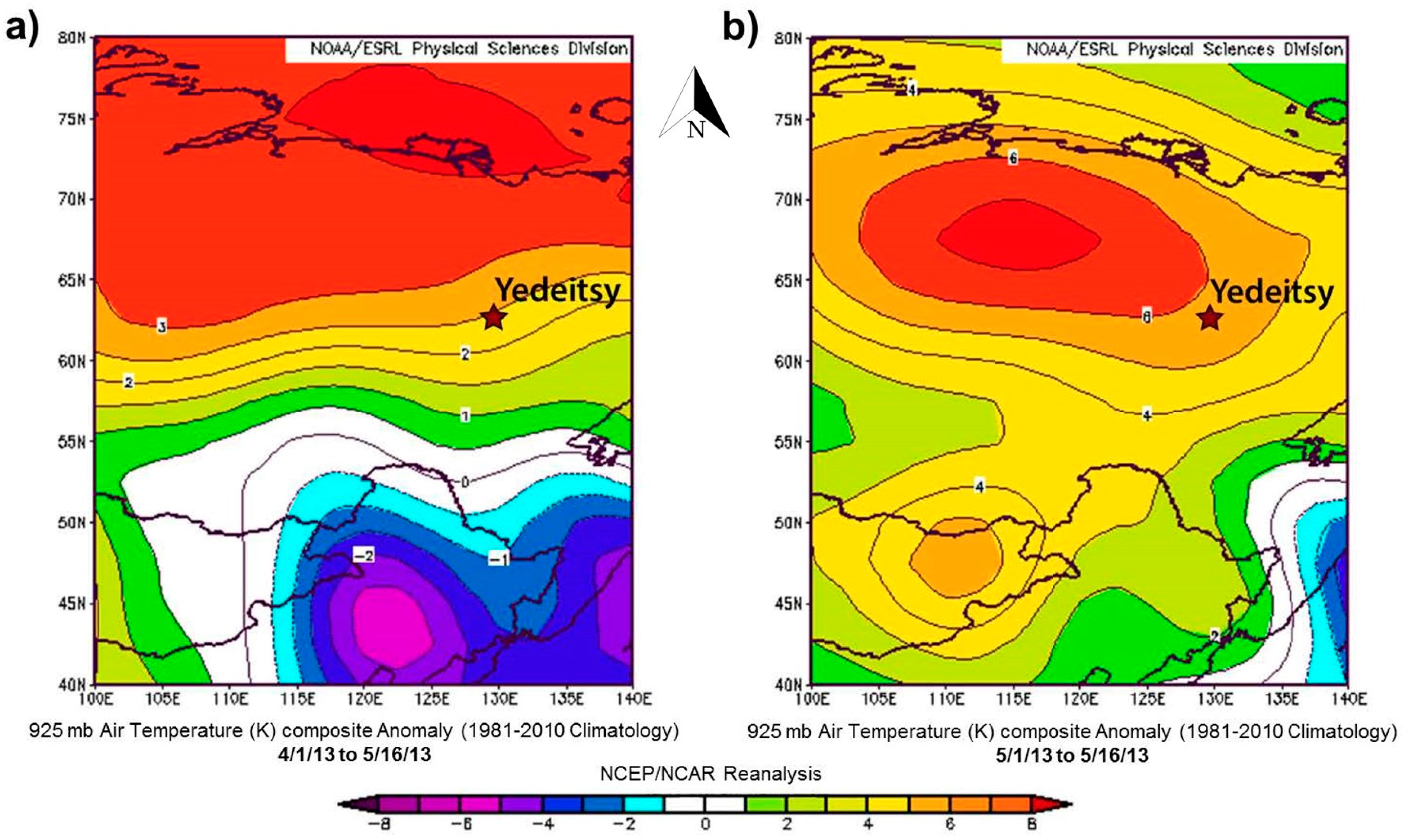
Extreme changes in local air temperatures played a key role in the severity of the 2013 flood in Galena [
5]. April and early May 2013 were the coldest since 1924 at all long-term observation stations in Interior Alaska. The monthly mean temperatures were significantly below freezing (
Figure 3a). In early May, temperatures were consistently much warmer over the headwaters and upper Yukon River drainages than across central Alaska (
Figure 3b). Significant melting in the headwaters initiated the spring freshet and the consequent river ice breakup. However, the ice in Interior Alaska was still strong and even grew in thickness. As a result, several ice jams formed along the middle reaches of the Yukon. The ice jam at Bishop Rock was so strong that it held for three days, backing the floodwaters and ice debris almost 30 km upstream to Galena, and 20 km beyond [
5].
No weather extremes or anomalies were observed during and prior to the flood in Edeytsy (
Figure 4a,b). At all long-term observation stations along the Lena River, April through early May 2013 temperatures were close to average. Furthermore, the temperatures in the central and northern parts of the Lena River watershed in early May 2013 were warm (
Figure 4b). Thus, the breakup was uniform throughout the main channel, where no major ice jams were reported. The ice jam that caused flooding in Edeytsy formed due to the accumulation of ice chunks in the shallow braided streams (the toe of the ice jam formed approximately 40 km downstream) and water discharge lower than the ice clearing discharge. The ice jam lasted for three days, backing water and ice debris to Edeytsy.
5.2. Understanding Exposure Drivers
Exposure is a defining component of flood risk. If no people or their assets are exposed to an ice-jam flood during its occurrence, then there is no risk, and subsequently no disaster. Political and economic incentives played key roles in the original settlement of Galena and Edeytsy in their current flood-prone locations, and their further growth in flood exposure.
Traditionally, Native communities in Alaska and Yakutia avoided spring floods by not establishing permanent settlements in floodplains. Seasonally nomadic, Native Alaskans migrated between their fishing and hunting camps [
26]. Native Yakuts originally settled around lakes located on higher ground, and descended to the rivers only for fishing and transportation purposes [
27]. Compelled by government programs to settle on floodplains in more permanent structures and communities in the first half of the 20th century, Native Alaskans and Yakuts began to face flood risk.
Flood risk increases as more people and assets become exposed [
8]. Therefore, the growing concentration of people, infrastructure, livelihoods, and services close to the riverbanks has been driving flood exposure in Galena and Edeytsy for the last eight decades. Attempts to reduce exposure have been implemented in both communities with varying degrees of success.
5.2.1. Galena, Alaska: Historical Overview of Exposure Drivers
Historical analysis revealed that the Koyukon Athabascans traditionally moved through their seasonal camps in interior Alaska, following the seasonal migration of wild game. Propelled by the need to work for wages at the ore mine in its current location, the first permanent population settled in Galena in 1920 [
26]. Flood risk was not factored into the investment decisions during the initial settlement of the community as people settled in log houses, which are easy to dismantle and dry out after the floods. Establishment of a U.S. Air Force (USAF) base in Galena in 1941 provided economic and political incentives for the community’s expansion. As the community grew, so did its dependence on the life-sustaining infrastructure and housing. Continuing not to invest in flood risk reduction measures left Galena’s residents and their assets exposed and vulnerable to breakup floods.
In 1993, the USAF base was deactivated in Galena, and its entire infrastructure (except for the state-owned airfield) was transferred to the village. The former airport base is the only part of Galena that is protected from breakup floods by a dike, which was constructed and have not been renovated since 1945. In 1997, USAF buildings were turned into classrooms and dormitories of the Galena Interior Learning Academy (GILA).
As revealed in focus group discussions and surveys, the airfield and former airbase infrastructure are crucial during flood relief and recovery operations. During the 2013 flood, Galena residents took shelter in GILA’s dorms, while emergency managers set up their camps on the only dry land behind the dike. The water-free airfield facilitated evacuations and transportation of emergency personnel and supplies to the impacted community. According to Galena’s administration and reports from the Alaska Division of Homeland Security and Emergency management (ADHSEM), the dike came very close to breeching during the flood in May 2013, and still needs to be repaired to restrain future floods. According to focus group discussion with Galena’s administration, the village does not have enough funds to take up a million-dollar project, while the USAF no longer sees it as their responsibility.
In addition to the construction of the dike, spring flood mitigation and prevention measures in Galena’s history included partial relocation and elevation of houses on steel pilings. After the ice jam flood in May 1971, a subdivision called New Town was constructed one mile upriver with the goal to relocate Galena residents farther from the floodplain. Opinions of the local population regarding relocation were not accounted for when choosing the new site’s location. For the construction of Galena’s New Town, the Alaska State Housing Authority (ASHA) allocated a site near Alexander Lake approximately one mile away from Old Town. ASHA surveyed the proposed relocation site and determined that it was appropriate for relocation as “it has received very little water during this record high flood” [
28]. As stated in the 1971 News Miner (State newspaper) article, “... villagers felt the [proposed relocation] site was too low.... and [thus] wanted to move the village onto high ground on the Campion site, ... but it was unlikely federal approval could be obtained for such a move” [
28]. At the time, the Campion site was the USAF dumpsite. The Campion site remained dry during all flood years, including 2013.
The 2013 flood inundated New Town and destroyed or severely damaged over 90 percent of the entire infrastructure and residences. Overall, the 2013 spring floods caused over 70 million dollars of damage in rural Alaska, thus impelling local administrations to call for state and federal disaster response and recovery funds. As a result, an array of stakeholders from governmental, non-governmental and private sectors were engaged in flood relief and recovery (
Table 3). Interagency response that proceeded sequentially rather than collaboratively in parallel led to significant delays in Galena’s recovery.
5.2.2. Edeytsy, Yakutia: Historical Overview of Exposure Drivers
Similarly to Galena, flood risk was not factored into the investment decisions during the initial settlement of Edeytsy in its current floodplain location. Prior to the late 1920s, Yakut people were nomadic and lived in groups that rarely exceeded 30 people [
27]. According to the 1926 census, there were over 11 thousand rural settlements in Yakutia with a mean population of 23.3 [
29]. Similarly to Koyukon Athabascans, Native Yakuts followed the seasons by migrating between their winter and summer camps and therefore were not at risk from breakup floods.
The historical records revealed that Edeytsy, as a municipality, was formed in 1930 by the Soviet government. Establishment of the Soviet regime and collectivization (i.e., a policy of forced consolidation of individual peasant households into collective farms, carried out by the Soviet government in the late 1920’s–early 1930’s) throughout Yakutia co-occurred with forced settlements of populations into permanent locations. Several Native groups were integrated into Edeytsy to advance local collective farms. Edeytsy was settled on the river to facilitate irrigation and water supplies for large cattle herds. The initial flood risk has amplified over decades due to the river channel migration and population increase.
To minimize flood risk, a range of flood risk reduction measures have been implemented in Edeytsy. With financial support from the state government, the construction of a dike was initiated after the breakup flood in May 2010 (the second largest flood on record). Due to incremental funding, construction of the dike was not completed prior to the flood in May 2013; construction is still ongoing. After the 2013 flood, a few residences and key public buildings (e.g., school, kindergarten, clinic, and office of the local administration) were elevated.
According to Edeytsy local administration, a completed dike, elevated houses, and continuous mechanical mitigation efforts (e.g., ice jam blasting and dusting) should protect Edeytsy from future spring floods. Edeytsy, as most rural riverine communities in Yakutia, relies predominantly on mechanical ice jam prevention and removal measures. When dangerous ice jams form, a series of ice removal operations (e.g., ice blasting) take place. Although ice jam prevention and removal measures are regularly implemented, they are not always effective. Decisions regarding flood risk and crisis management efforts in Edeytsy are co-produced by a group of federal, state, and local stakeholders (
Table 4).
5.3. Understanding Vulnerability Progression
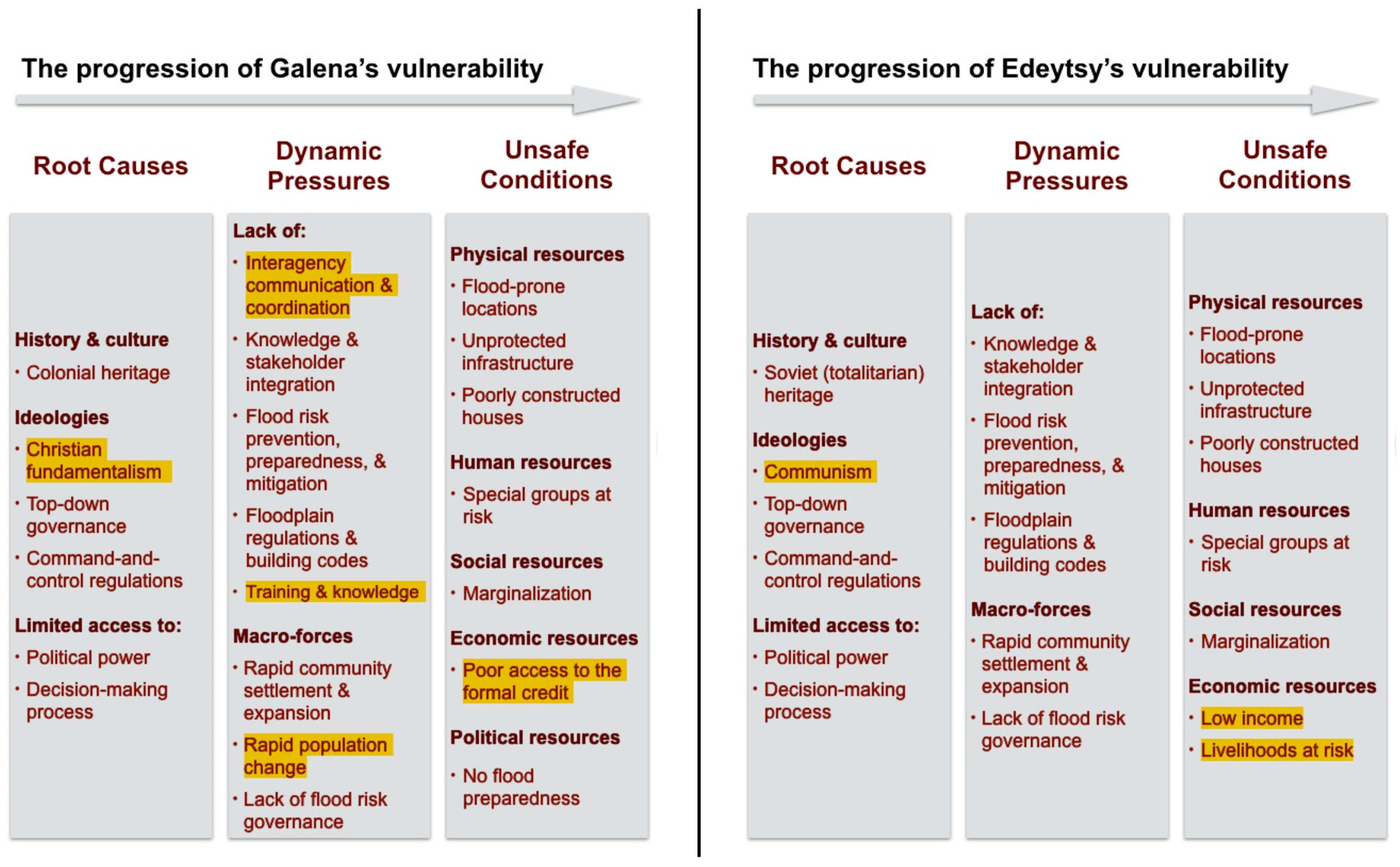
Vulnerability is the third defining component of flood risk, and a human dimension of the disaster, which represents a range of economic, political, institutional, environmental, and social factors that makes a community susceptible to spring floods. Historical analysis of spring floods in Galena and Edeytsy point to common root causes between the two research sites, including colonial heritage, top-down governance, and limited inclusion of local communities into the decision making process (
Figure 5).
Implementing the PAR model to analyze the vulnerability progression of Edeytsy and Galena has demonstrated that the vulnerability of both communities is deeply rooted in socio-economic and political processes (
Figure 5). As mentioned above, Galena and Edeytsy were formed into permanent settlements rather abruptly by their state governments in the first half of the 20th century. Neither local population, nor local knowledge about ice-jam floods were factored into the original decision-making processes. Although pursuing different underlying goals (e.g., establishment of a collective farm in Edeytsy and an ore-mining base and later a USAF base in Galena), state governments in Alaska and Yakutia similarly focused on rapid community settlement and expansion. The original absence of flood risk governance resulted in a lack of building codes, and flood prevention, mitigation, and preparedness measures. For decades, flood-ravaged houses in Galena and Edeytsy were quickly rebuilt on the same places with no intent to reduce the populations’ exposure and vulnerability to spring floods.
5.4. Understanding Springtime Flood Risk Reduction in Alaska and Yakutia
Unlike most natural disasters, opportunities for reducing spring flood risk lie not only in reducing vulnerability and exposure of the at-risk population, but also reducing the frequency and severity of the hazard itself. Throughout history, an array of ice jam prevention and mitigation measures have been implemented in the US and Russian North with varying degrees of success [
2,
30]. Every mitigation and prevention technique has potential benefits and drawbacks (
Table 5). The selection of a particular mitigation technique or a combination of techniques should depend not only upon the availability of resources and time, but also the careful analysis of the causative factors of ice jam [
2,
30]. Independent causative factors, such as unique geographic, geological, and morphological features of the river channel and the floodplain, and dependent factors, such as hydro-meteorological conditions, and water release from upstream reservoirs should be thoroughly evaluated. The history of floodplain management and progression of a population’s vulnerability to floods should also be included in the analysis.
The analysis of focus group discussions with US and Russian representatives from the agencies responsible for flood risk management revealed two key categories of ice-jam flood prevention and mitigation strategies in Alaska and Yakutia (
Table 5):
Ice jam prevention: preventive measures to eliminate or lessen the likelihood of a damaging ice jam event from occurring.
Reduction of ice-jam flood impact: preventive measures to reduce the potential adverse impacts from floodwater and ice floes. These measures are further divided into structural and nonstructural.
In both communities, a combination of structural and mechanical mitigation techniques were implemented throughout the history with the goal to either prevent ice jams from occurring or reducing the adverse impacts of ice-jam floods. Examples include construction of dikes, elevation of houses and infrastructure, partial relocation of at-risk population, and ice jam breaching and removal. Mechanical ice jam mitigation efforts, such as ice jam breaching and removal had been implemented in Alaska from the mid-1940s until late 1980s, and are still largely implemented in Yakutia, and other Russian Arctic regions.
Mechanical ice jam mitigation techniques are more proactive, but not necessarily effective, and could aggravate the flooding severity if not properly managed and applied. These techniques are designed according to hydrological models developed by academic and federal scientists; however, no criteria for the effectiveness of these models have yet been established [
30]. Therefore, existing evidence of these methods’ effectiveness is predominantly anecdotal. According to the focus groups, 52,000 dollars were invested in ice cutting and dusting measures along the Lena River in spring 2013. Yet, the breakup resulted in significant flooding.
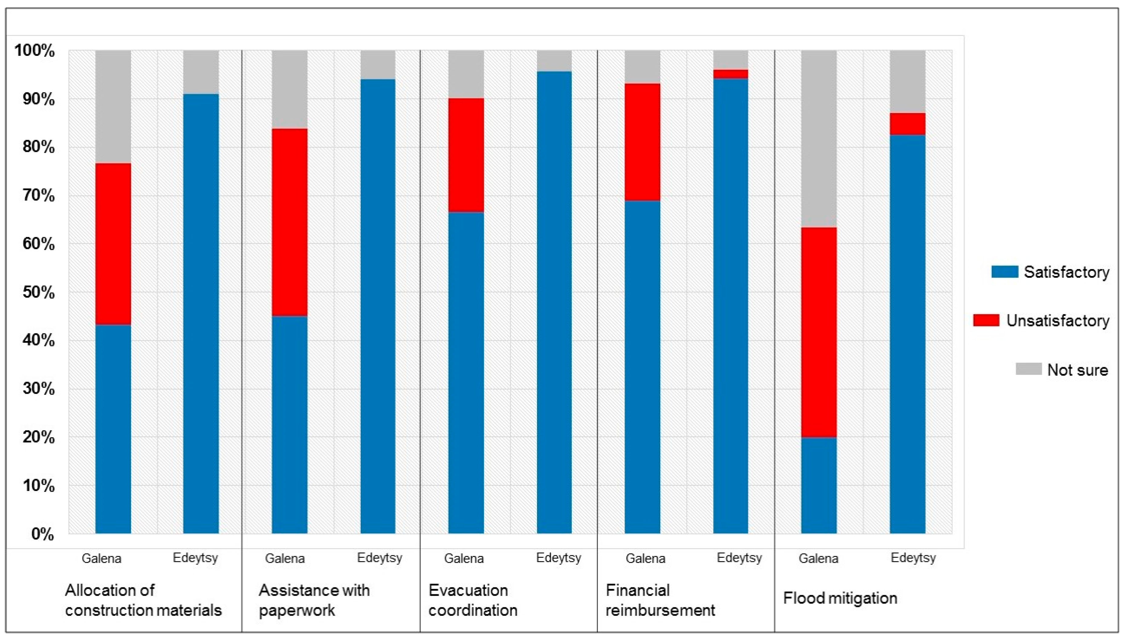
Nevertheless, survey results revealed a higher satisfaction rating with the mitigation and prevention measures among Edeytsy residents (
Figure 6). Participant observations revealed disappointment among the residents in Galena and other rural riverine communities in Alaska regarding the absence of mechanical ice-jam mitigation efforts. Watching their communities ravaged by ice floes, people hoped for prevention efforts. In addition to the placebo effect, mechanical mitigation efforts might help reduce or even eliminate adverse impacts of spring floods. However, further comparative analysis is needed to determine the costs, benefits, and effectiveness of the mechanical ice jam mitigation efforts.
Despite mitigation measures, in most cases, some people and property remain vulnerable to floods. Thus, flood preparedness is an integral component of flood risk reduction. Flood preparedness encompasses activities that increase a population’s ability to predict, prepare for, as well as respond to and recover from disasters. During the 2013 floods, preparedness measures in Galena and Edeytsy included early warning, evacuation of at-risk population and livestock to higher ground, and facilitation of rapid response.
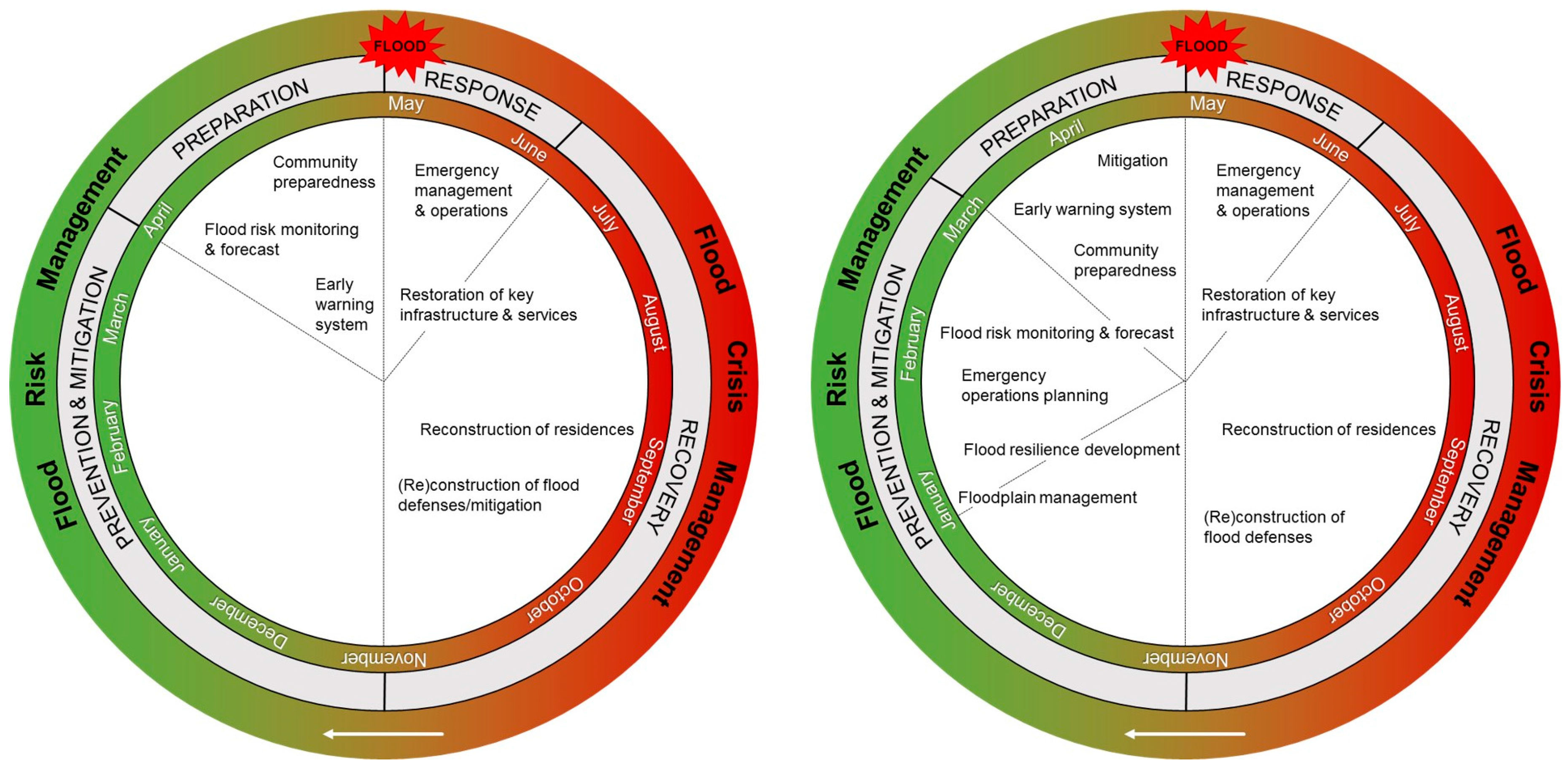
In Alaska and Yakutia, multiple stakeholders from federal, state, and local governmental agencies, as well as NGOs and the private sector engage in flood risk and crisis management (
Table 3 and
Table 4,
Figure 7). In Yakutia, coordination of breakup flood mitigation, preparedness, response, and recovery efforts are organized at the federal level. This unified and centralized system encourages an ongoing year-round interagency communication between throughout the flood cycle (
Figure 7). The Yakut model has four key phases:
Approximately four months prior to the breakup onset, an interagency working group forms to allocate the necessary resources for flood prevention, mitigation, preparedness, and potential relief and recovery efforts, and to assign tasks and responsibilities among stakeholders involved in flood risk and crisis management. The group consists of representatives from federal, republic, and regional emergency preparedness and relief agencies and local governments. The group’s decision-making is based on the breakup and flood forecasts from Federal Service for Hydrometeorology and Environmental Monitoring of Russia (Roshydromet).
Around two months prior to the breakup onset, the working group begins to collaborate on detailed flood risk and crisis reduction strategies. The working group identifies communities at risk, and determines appropriate short-term (mechanical) ice jam mitigation measures (
Table 5), based on the up-to-date breakup forecast from Roshydromet. At this stage, flood watches are issues for the at-risk communities. Representatives from state and regional agencies responsible for spring flood management initiate collaborations with local administrations about flood preparedness, prevention, and potential flood relief and recovery efforts.
Approximately four-to-two weeks prior to the (potential) flood onset (based on the breakup progression in headwater regions of the Lena River watershed and regional weather conditions), state emergency management specialists conduct mechanical ice jam and flood mitigation efforts, including river ice weakening (i.e., ice cutting and dusting), and detonation. Meanwhile, local administrations initiate community preparedness by establishing emergency response posts, and informing the population at risk about potential floods and mandatory evacuation. Evacuation of special groups at risk (e.g., elders, children, and disabled residents), as well as relocation of cattle, cars, and farm equipment, begins two-to-three days prior to the potential flood.
After the floodwaters recede, an interagency commission systematically evaluates the damages and determines individual (family) and public compensation. As soon as the damage assessments are completed (usually by late June or early July), the rebuilding of houses as well as critical infrastructure and services begins. The duration of flood recovery depends on the remoteness and isolation of the impacted communities, and the extent of damage.
The described above unified and centralized flood management system facilitates the availability of the necessary financial and human resources to execute flood prevention and relief efforts in a timely and effective manner. However, in this scenario the Russian and Yakut state governments administrate flood management programs via top-down regulations at the detriment of local actions. Local governments do not take part in flood management planning, but are merely tasked to relay actions from the top down. Opinions and knowledge of the population at risk are not encouraged or incorporated in the decision-making.
In Yakutia, flood management is executed predominantly by federal emergency management agents, which rely on military chain of commands and top-down regulations. Since the underlying political, economic, social, and cultural causes of spring floods are not regarded as civil-defense matters, they remain largely ignored. After flood recovery is completed, the community’s vulnerability still remains. Continuing not to include local stakeholders into the decision-making process would further propagate the implementation of flood management strategies that do not help to reduce the communities’ vulnerability and risk drivers.
In Alaska, the breakup flood cycle begins with flood response efforts (
Figure 7). No centralized flood risk reduction efforts are conducted prior to the breakup onset. Once a flood overwhelms a community’s capacity, local administration requests the state’s support. If the flood exceeds the state’s resources, the governor requests a federal disaster declaration, and support. This succession significantly delayed relief and recovery efforts in Alaska 2013; over half of Galena’s population remained in a two-years-long evacuation [
5,
6].
6. Conclusions
River ice thawing and breakup is an annual springtime phenomenon in the Arctic. Depending on regional weather patterns and river morphology, breakups can result in floods. Breakup floods often cause catastrophic ice and water damage to expose and vulnerable riverine communities, and lead to socioeconomic and ecological crisis. Via a comparative analysis between two flood-prone communities—Galena in Alaska and Edeytsy in Yakutia, we identified key components of springtime flood risk in rural Artic communities, and analyzed the effectiveness of the existing flood risk reduction efforts.
Historical analysis revealed that spring flood risk in Galena and Edeytsy has resulted from complex interactions between a series of natural processes and human actions that generated conditions of hazard, exposure, and vulnerability. Therefore, flood risk in Galena and Edeytsy can be reduced by managing conditions of ice-jam floods, and decreasing exposure and vulnerability of the populations at risk. Implementing the PAR model to analyze the vulnerability progression of Edeytsy and Galena has demonstrated that the vulnerability of both communities is deeply rooted in socioeconomic and political processes. The progression of vulnerability in Galena and Edeytsy point to common root causes between the two research sites, including colonial heritage, top-down governance and limited inclusion of local communities into the decision-making process.
The communities of Galena and Edeytsy were settled in their permanent floodplain locations with no consideration of flood risk. Rapid expansion of both communities, along with miscommunication or lack of communication between stakeholders responsible for managing flood risks and those facing flood risks resulted in inadequate flood risk governance and management measures. Reducing vulnerability is only possible through integration of local knowledge stakeholders in the decision-making processes regarding spring flood management.
Unlike most natural disasters, opportunities for reducing spring flood risk lie not only in reducing vulnerability drivers, but also in reducing the severity of the hazard itself. Throughout history, an array of ice jam prevention and mitigation measures have been implemented in the US and Russian North with varying degrees of success. A series of mechanical ice jam mitigation and prevention techniques (e.g., ice dusting, blasting, and cutting) are implemented in the Russian North during every spring breakup. Although these measures are more proactive, the existing evidence of their effectiveness is predominantly anecdotal.
The selection of mitigation efforts should depend on the careful analysis of the causative factors of ice jams, and the unique features of the river channel and the floodplain. The decisions should be made collectively by representatives from at-risk communities and flood managing agencies, and should be based on coherent science-based assessments. In practice, spring flood mitigation strategies are predominantly selected upon the availability of resources and time of flood managing agencies.
Spring floods are complex natural and social phenomena. Their scale, frequency, and impact can be effectively addressed only through holistic policy solutions, which are based on thorough and coherent assessments of flood risks.
Integrated flood risk reduction requires interdisciplinary research and interagency collaborations with a diverse group of stakeholders. Although increasingly regarded by both scholars and practitioners as a crucial step in reducing disaster risk, integrating knowledge, actions and stakeholders in disaster risk reduction remains challenging in policy and practice primarily due to the lack of trust between stakeholders. To facilitate integrated spring flood risk reduction in the rural North, it is crucial to provide a space for a dialogue among key stakeholders, including communities facing flood risk.
Ice-jam floods regularly impact multiple regions in the high latitudes besides Russia and the United States. Thus, emergency managers, policymakers, and communities at flood risk throughout the high latitudes would find lessons from this study useful. It is nevertheless important to remember that underlying flood risk drivers differ in every community, and so should flood risk reduction approaches. To construct an appropriate flood risk reduction framework it is vital to foremost conduct an integrated assessment of flood risk based on local and scientific knowledge, followed by establishing a dialogue among the diverse stakeholders on issues and potential solutions, and finally arriving at a range of top-down and bottom-up initiatives, and in conjunction selecting the appropriate strategies.

 ,
, 


