High-Resolution Topographic Analyses of Mounds in Southern Acidalia Planitia, Mars: Implications for Possible Mud Volcanism in Submarine and Subaerial Environments


Abstract
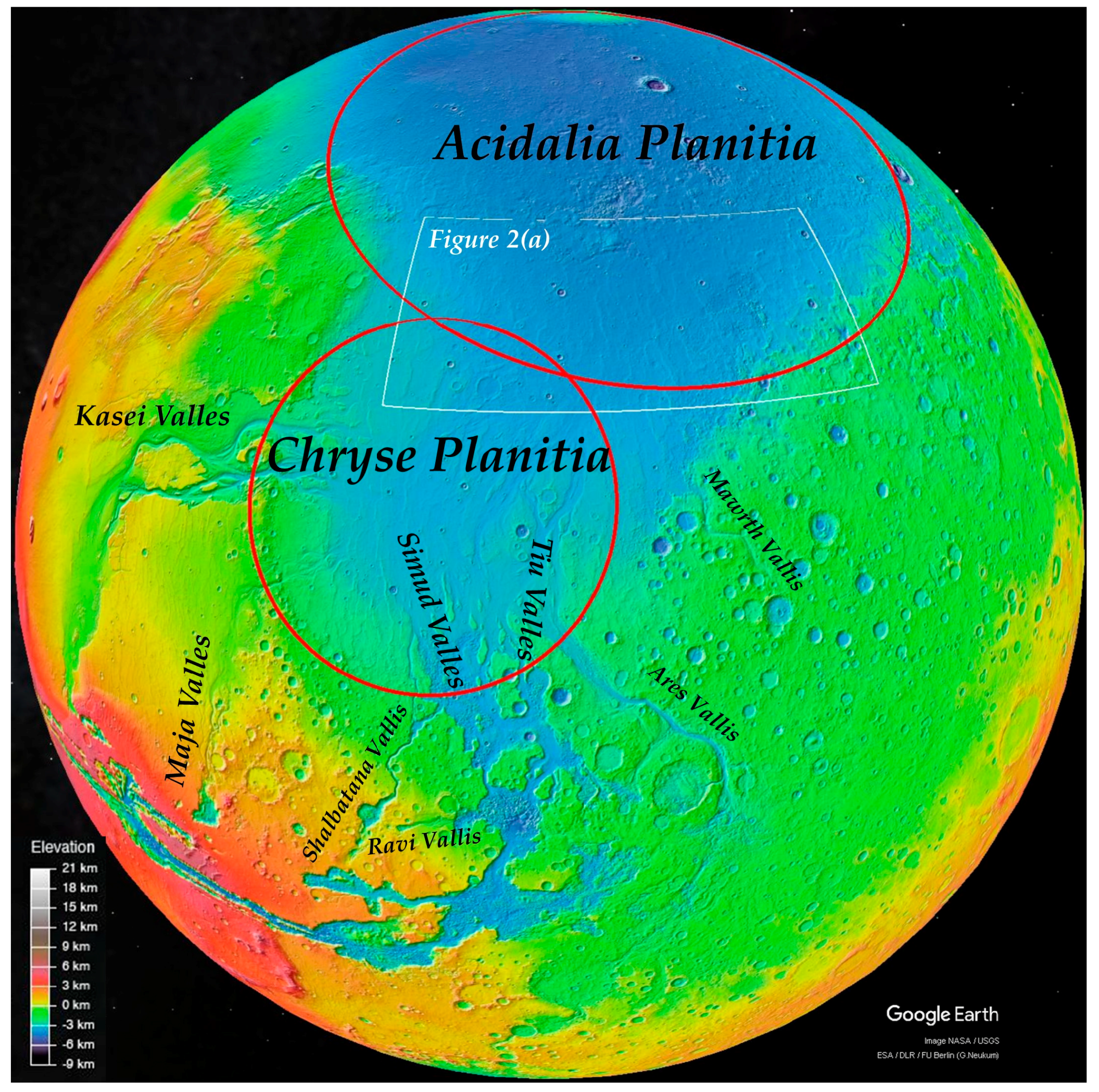
:1. Introduction
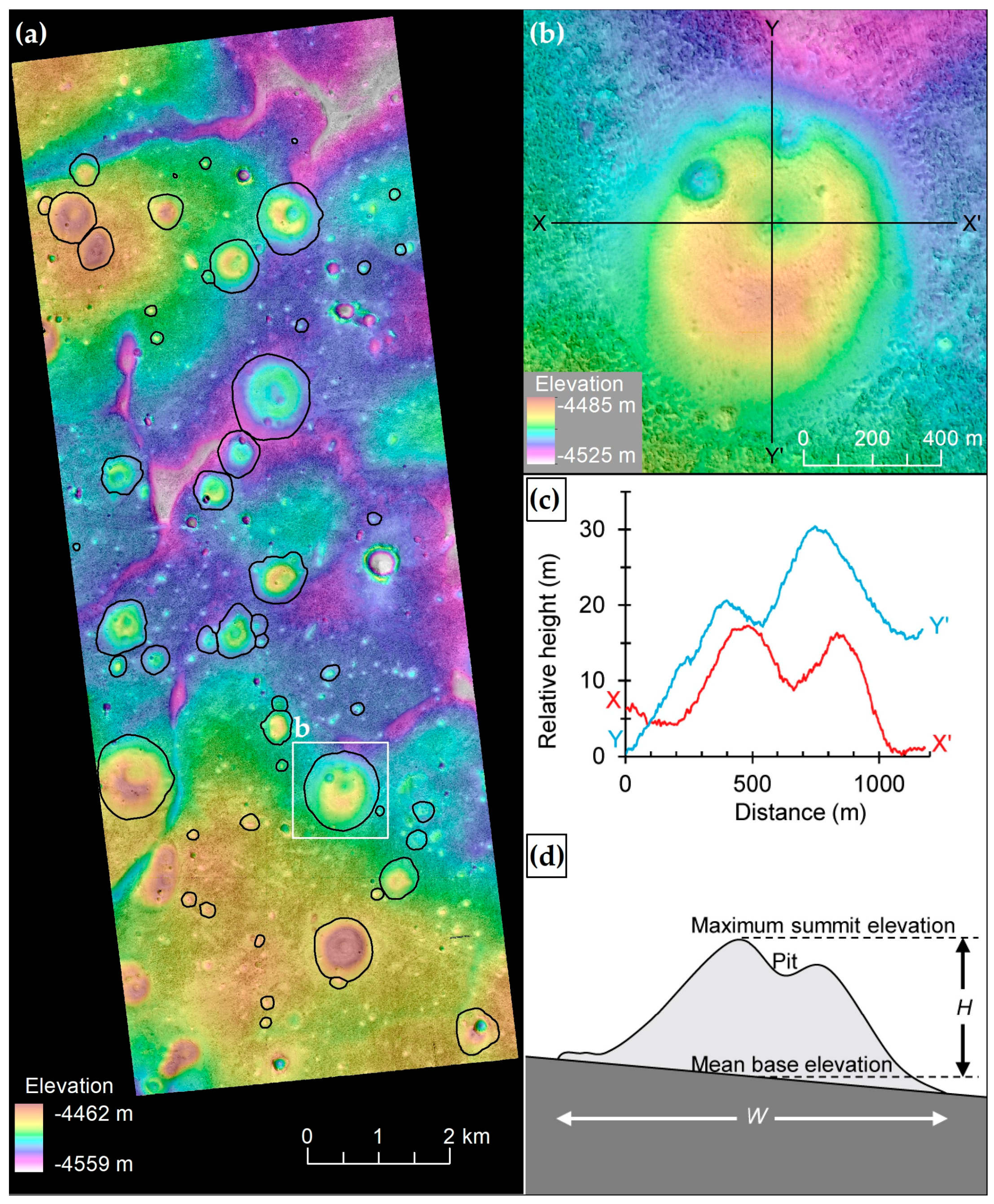
2. Data and Methods
3. Results
4. Discussion
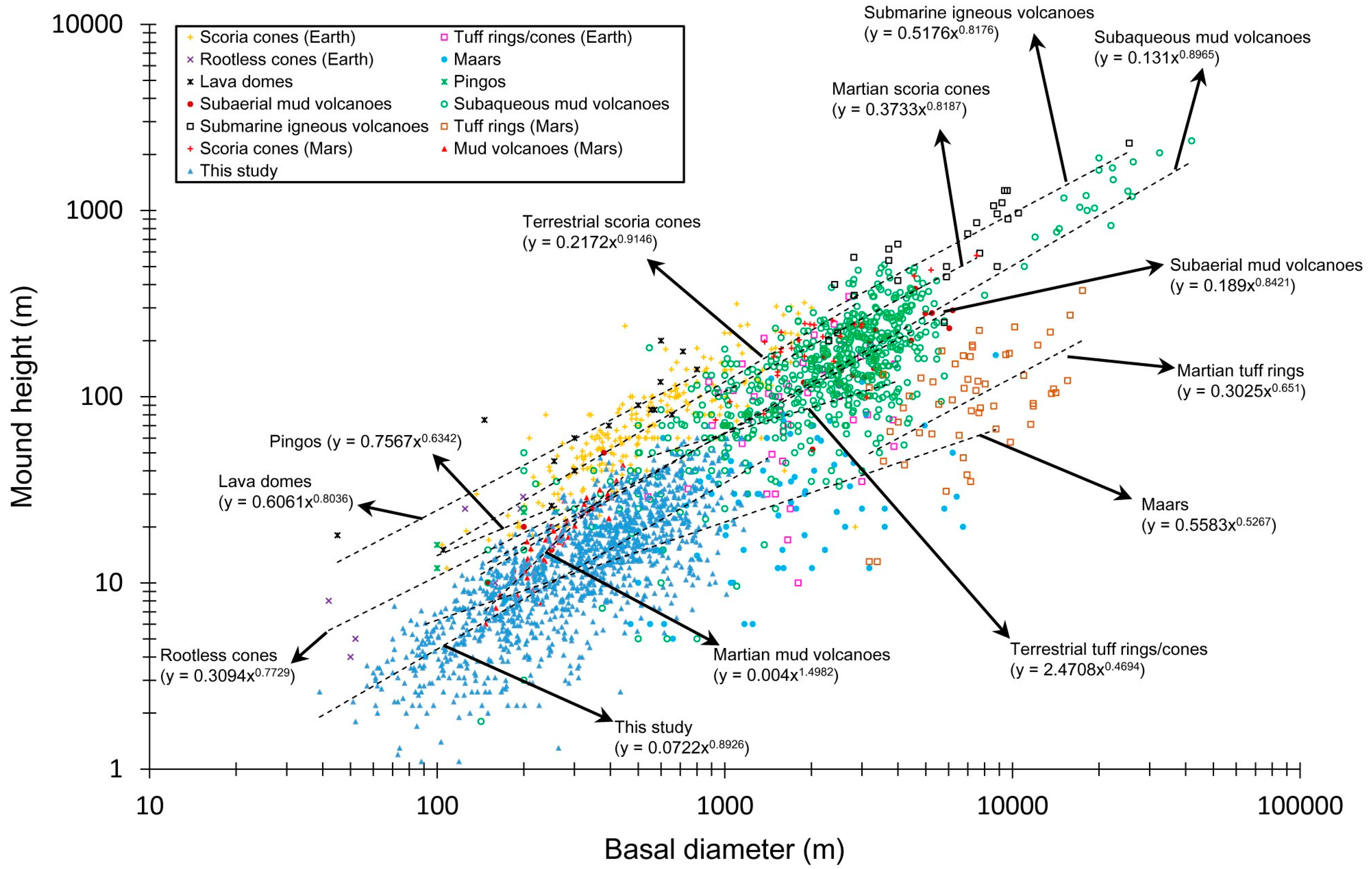
4.1. Comparison of Morphometric Parameters among Possible Origins
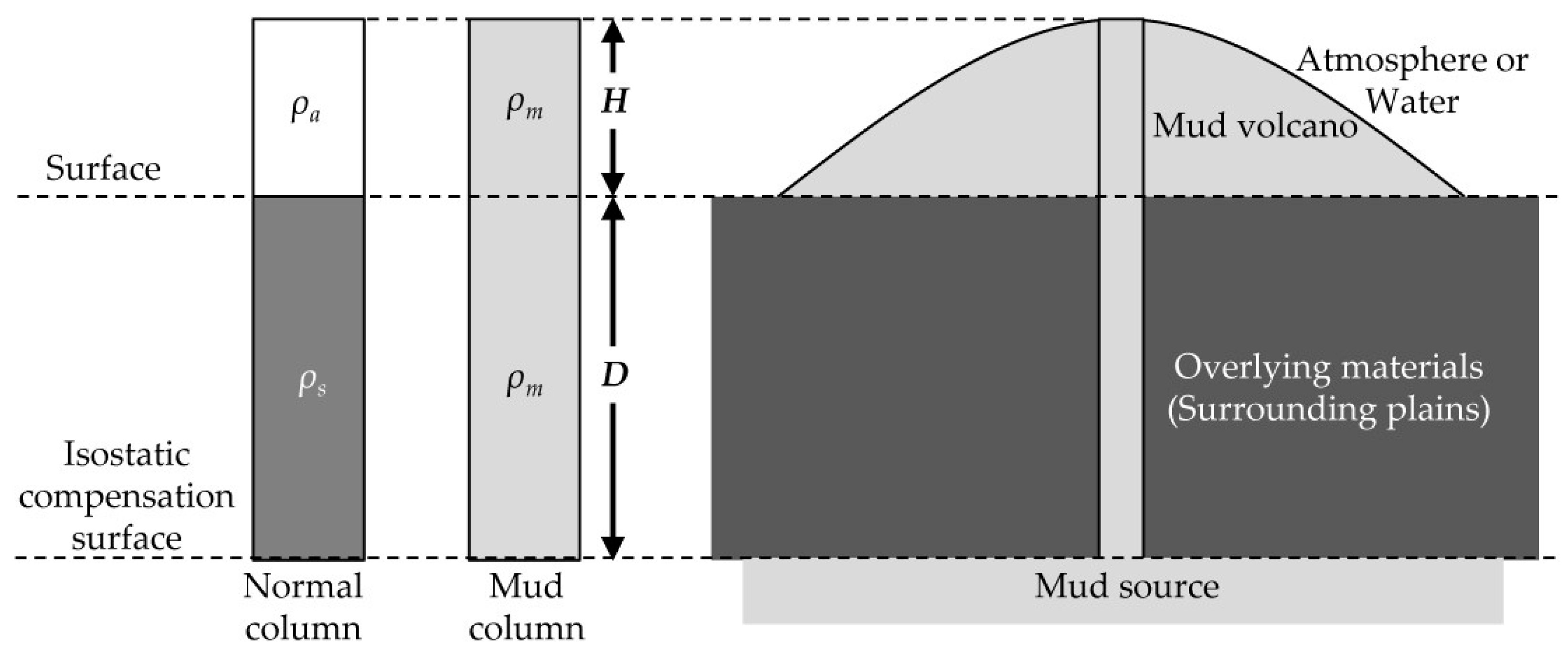
4.2. Depths of the Sources in Subaqueous or Subaerial Conditions
4.3. Testing the Rheology of Fluid Flows
4.4. Geological Context of the Mounds in Acidalia Basin
5. Conclusions
Supplementary Materials
Author Contributions
Acknowledgments
Conflicts of Interest
References
- Baker, V.R.; Strom, R.G.; Gulick, V.C.; Kargel, J.S.; Komatsu, G.; Kale, V.S. Ancient oceans, ice sheets and the hydrological cycle on mars. Nature 1991, 352, 589. [Google Scholar] [CrossRef]
- Clifford, S.M.; Parker, T.J. The evolution of the martian hydrosphere: Implications for the fate of a primordial ocean and the current state of the northern plains. Icarus 2001, 154, 40–79. [Google Scholar] [CrossRef]
- Parker, T.J.; Gorsline, D.S.; Saunders, R.S.; Pieri, D.C.; Schneeberger, D.M. Coastal geomorphology of the martian northern plains. J. Geophys. Res. Planets 1993, 98, 11061–11078. [Google Scholar] [CrossRef]
- Parker, T.J.; Stephen Saunders, R.; Schneeberger, D.M. Transitional morphology in west deuteronilus mensae, mars: Implications for modification of the lowland/upland boundary. Icarus 1989, 82, 111–145. [Google Scholar] [CrossRef]
- Baker, V.R.; Milton, D.J. Erosion by catastrophic floods on mars and earth. Icarus 1974, 23, 27–41. [Google Scholar] [CrossRef]
- Carr, M.H. The Surface of Mars; Cambridge University Press: Cambridge, UK, 2007. [Google Scholar]
- Scott, D.H.; Tanaka, K.L. Geologic Map of the Western Equatorial Region of Mars; USGS: Reston, VA, USA, 1986.
- Tanaka, K.L.; Scott, D.H. Geologic Map of the Polar Regions of Mars; USGS: Reston, VA, USA, 1987.
- Kreslavsky, M.A.; Head, J.W. Fate of outflow channel effluents in the northern lowlands of mars: The vastitas borealis formation as a sublimation residue from frozen ponded bodies of water. J. Geophys. Res. Planets 2002, 107, 4-1–4-25. [Google Scholar] [CrossRef]
- Head, J.W.; Kreslavsky, M.A.; Pratt, S. Northern lowlands of mars: Evidence for widespread volcanic flooding and tectonic deformation in the hesperian period. J. Geophys. Res. Planets 2002, 107, 3-1–3-29. [Google Scholar] [CrossRef]
- Head, J.W.; Hiesinger, H.; Ivanov, M.A.; Kreslavsky, M.A.; Pratt, S.; Thomson, B.J. Possible ancient oceans on mars: Evidence from mars orbiter laser altimeter data. Science 1999, 286, 2134–2137. [Google Scholar] [CrossRef] [PubMed]
- Ivanov, M.A.; Erkeling, G.; Hiesinger, H.; Bernhardt, H.; Reiss, D. Topography of the deuteronilus contact on mars: Evidence for an ancient water/mud ocean and long-wavelength topographic readjustments. Planet. Space Sci. 2017, 144, 49–70. [Google Scholar] [CrossRef]
- Citron, R.I.; Manga, M.; Hemingway, D.J. Timing of oceans on mars from shoreline deformation. Nature 2018, 555, 643–646. [Google Scholar] [CrossRef] [PubMed]
- Carr, M.H. Water on Mars; Oxford University Press: New York, NY, USA, 1996. [Google Scholar]
- Turbet, M.; Forget, F.; Head, J.W.; Wordsworth, R. 3D modelling of the climatic impact of outflow channel formation events on early mars. Icarus 2017, 288, 10–36. [Google Scholar] [CrossRef]
- Oehler, D.Z.; Allen, C.C. Focusing the search for biosignatures on mars: Facies prediction with an example from acidalia planitia. In Sedimentary Geology of Mars; Grotzinger, J.P., Milliken, R.E., Eds.; SEPM (Society for Sedimentary Geology): Tulsa, OK, USA, 2012. [Google Scholar]
- Lucchitta, B.K.; Ferguson, H.M.; Summers, C. Sedimentary deposits in the northern lowland plains, mars. J. Geophys. Res. Solid Earth 1986, 91, E166–E174. [Google Scholar] [CrossRef]
- Frey, H. Ages of very large impact basins on mars: Implications for the late heavy bombardment in the inner solar system. Geophys. Res. Lett. 2008, 35, L13203. [Google Scholar] [CrossRef]
- Martínez-Alonso, S.; Mellon, M.T.; Banks, M.E.; Keszthelyi, L.P.; McEwen, A.S.; Team, T.H. Evidence of volcanic and glacial activity in chryse and acidalia planitiae, mars. Icarus 2011, 212, 597–621. [Google Scholar] [CrossRef]
- Ramsdale, J.D.; Balme, M.R.; Conway, S.J.; Gallagher, C.; van Gasselt, S.A.; Hauber, E.; Orgel, C.; Séjourné, A.; Skinner, J.A.; Costard, F.; et al. Grid-based mapping: A method for rapidly determining the spatial distributions of small features over very large areas. Planet. Space Sci. 2017, 140, 49–61. [Google Scholar] [CrossRef]
- Oehler, D.Z.; Allen, C.C. Evidence for pervasive mud volcanism in acidalia planitia, mars. Icarus 2010, 208, 636–657. [Google Scholar] [CrossRef]
- Hemmi, R.; Miyamoto, H. Distribution, morphology, and morphometry of circular mounds in the elongated basin of northern terra sirenum, mars. Prog. Earth Planet. Sci. 2017, 4, 26. [Google Scholar] [CrossRef]
- Tanaka, K.L. Sedimentary history and mass flow structures of chryse and acidalia planitiae, mars. J. Geophys. Res. Planets 1997, 102, 4131–4149. [Google Scholar] [CrossRef]
- Carr, M.H.; Head, J.W. Oceans on mars: An assessment of the observational evidence and possible fate. J. Geophys. Res. Planets 2003, 108. [Google Scholar] [CrossRef]
- Farrand, W.H.; Gaddis, L.R.; Keszthelyi, L. Pitted cones and domes on mars: Observations in acidalia planitia and cydonia mensae using moc, themis, and tes data. J. Geophys. Res. Planets 2005, 110, E05005. [Google Scholar] [CrossRef]
- McGill, G.E. Geologic Map of Cydonia Mensae—Southern Acidalia Planitia, Mars, Quadrangles MTM 40007, 40012, 40017, 45007, 45012, and 45017; U.S. Geological Survey Geologic Investigations Series I-2811; USGS: Reston, VA, USA, 2005.
- Tanaka, K.L.; Skinner, J.A.; Hare, T.M. Geologic map of the northern plains of mars. In U.S. Geological Survey Scientific Investigations Map 2888; USGS: Reston, VA, USA, 2005. [Google Scholar]
- Dundas, C.M.; Keszthelyi, L.P.; McEwen, A.S.; Team, H. Initial hirise observations of cratered cone groups on mars. In Proceedings of the 38th Lunar and Planetary Science Conference, League City, TX, USA, 12–16 March 2007; p. 2116. [Google Scholar]
- Skinner, J.A.; Mazzini, A. Martian mud volcanism: Terrestrial analogs and implications for formational scenarios. Mar. Pet. Geol. 2009, 26, 1866–1878. [Google Scholar] [CrossRef]
- Werner, S.C.; Tanaka, K.L.; Skinner, J.A. Mars: The evolutionary history of the northern lowlands based on crater counting and geologic mapping. Planet. Space Sci. 2011, 59, 1143–1165. [Google Scholar] [CrossRef]
- Platz, T.; Michael, G.; Tanaka, K.L.; Skinner, J.A.; Fortezzo, C.M. Crater-based dating of geological units on mars: Methods and application for the new global geological map. Icarus 2013, 225, 806–827. [Google Scholar] [CrossRef]
- Ivanov, M.A.; Hiesinger, H.; Erkeling, G.; Reiss, D. Evidence for large reservoirs of water/mud in utopia and acidalia planitiae on mars. Icarus 2015, 248, 383–391. [Google Scholar] [CrossRef]
- Warner, N.H.; Gupta, S.; Calef, F.; Grindrod, P.; Boll, N.; Goddard, K. Minimum effective area for high resolution crater counting of martian terrains. Icarus 2015, 245, 198–240. [Google Scholar] [CrossRef]
- Tanaka, K.L.; Skinner, J.A.J.; Dohm, J.M.; Irwin Iii, R.P.; Kolb, E.J.; Fortezzo, C.M.; Platz, T.; Michael, G.G.; Hare, T. Geologic map of mars, scale 1:20,000,000. In U.S. Geological Survey Scientific Investigations Map 3292; USGS: Reston, VA, USA, 2014. [Google Scholar]
- Amador, E.S.; Allen, C.C.; Oehler, D.Z. Regional mapping and spectral analysis of mounds in acidalia planitia, mars. In Proceedings of the 41st Lunar and Planetary Science Conference, The Woodlands, TX, USA, 1–5 March 2010; p. 1037. [Google Scholar]
- Skinner, J.A. Constraining the origin of pitted cones in chryse and acidalia planitiae, mars, based on their statistical distributions and marginal relationships. In Proceedings of the 43rd Lunar and Planetary Science Conference, The Woodlands, TX, USA, 19–23 March 2012; p. 2905. [Google Scholar]
- Frey, H.; Lowry, B.L.; Chase, S.A. Pseudocraters on mars. J. Geophys. Res. Solid Earth 1979, 84, 8075–8086. [Google Scholar] [CrossRef]
- Lucchitta, B.K. Mars and earth: Comparison of cold-climate features. Icarus 1981, 45, 264–303. [Google Scholar] [CrossRef]
- Frey, H.; Jarosewich, M. Subkilometer martian volcanoes: Properties and possible terrestrial analogs. J. Geophys. Res. Solid Earth 1982, 87, 9867–9879. [Google Scholar] [CrossRef]
- Carr, M.H. Mars: A water-rich planet? Icarus 1986, 68, 187–216. [Google Scholar] [CrossRef]
- Fagents, S.A.; Lanagan, P.; Greeley, R. Rootless cones on mars: A consequence of lava-ground ice interaction. Geol. Soc. Lond. Spec. Publ. 2002, 202, 295–317. [Google Scholar] [CrossRef]
- Ann Hodges, C.; Moore, H.J. The subglacial birth of olympus mons and its aureoles. J. Geophys. Res. Solid Earth 1979, 84, 8061–8074. [Google Scholar] [CrossRef]
- Wood, C.A. Monogenetic volcanoes of the terrestrial planets. In Proceedings of the 10th Lunar and Planetary Science Conference, Houston, TX, USA, 19–23 March 1979; pp. 2815–2840. [Google Scholar]
- Greeley, R.; Spudis, P.D. Volcanism on mars. Rev. Geophys. 1981, 19, 13–41. [Google Scholar] [CrossRef]
- Davis, P.A.; Tanaka, K.L. Morphometries and possible terrestrial analogs of small martian volcanoes. In Proceedings of the 25th Lunar and Planetary Science Conference, Houston, TX, USA, 14–18 March 1994; p. 317. [Google Scholar]
- Wilson, L.; Head, J.W. Mars: Review and analysis of volcanic eruption theory and relationships to observed landforms. Rev. Geophys. 1994, 32, 221–263. [Google Scholar] [CrossRef]
- Rossbacher, L.A.; Judson, S. Ground ice on mars: Inventory, distribution, and resulting landforms. Icarus 1981, 45, 39–59. [Google Scholar] [CrossRef]
- Komar, P.D. Mud volcanoes on mars. In Reports of Planetary Geology and Geophysics Program, 1990; NASA: Washington, DC, USA, 1991; pp. 539–541. [Google Scholar]
- Keszthelyi, L.P.; Jaeger, W.L.; Dundas, C.M.; Martínez-Alonso, S.; McEwen, A.S.; Milazzo, M.P. Hydrovolcanic features on mars: Preliminary observations from the first mars year of hirise imaging. Icarus 2010, 205, 211–229. [Google Scholar] [CrossRef]
- McGowan, E. Spatial distribution of putative water related features in southern acidalia/cydonia mensae, mars. Icarus 2009, 202, 78–89. [Google Scholar] [CrossRef]
- Oehler, D.Z.; Etiope, G. Methane seepage on mars: Where to look and why. Astrobiology 2017, 17, 1233–1264. [Google Scholar] [CrossRef] [PubMed]
- Milkov, A.V. Worldwide distribution of submarine mud volcanoes and associated gas hydrates. Mar. Geol. 2000, 167, 29–42. [Google Scholar] [CrossRef]
- Malin, M.C.; Bell, J.F.; Cantor, B.A.; Caplinger, M.A.; Calvin, W.M.; Clancy, R.T.; Edgett, K.S.; Edwards, L.; Haberle, R.M.; James, P.B.; et al. Context camera investigation on board the mars reconnaissance orbiter. J. Geophys. Res. Planets 2007, 112, E05S04. [Google Scholar] [CrossRef]
- Salvatore, M.R.; Christensen, P.R. On the origin of the vastitas borealis formation in chryse and acidalia planitiae, mars. J. Geophys. Res. Planets 2014, 119, 2437–2456. [Google Scholar] [CrossRef]
- Oehler, D.Z.; Allen, C.C. Giant polygons and mounds in the lowlands of mars: Signatures of an ancient ocean? Astrobiology 2012, 12, 601–615. [Google Scholar] [CrossRef] [PubMed]
- Allen, C.C.; Oehler, D.Z.; Etiope, G.; Van Rensbergen, P.; Baciu, C.; Feyzullayev, A.; Martinelli, G.; Tanaka, K.; Van Rooij, D. Fluid expulsion in terrestrial sedimentary basins: A process providing potential analogs for giant polygons and mounds in the martian lowlands. Icarus 2013, 224, 424–432. [Google Scholar] [CrossRef]
- Smith, D.E.; Zuber, M.T.; Frey, H.V.; Garvin, J.B.; Head, J.W.; Muhleman, D.O.; Pettengill, G.H.; Phillips, R.J.; Solomon, S.C.; Zwally, H.J. Mars orbiter laser altimeter: Experiment summary after the first year of global mapping of mars. J. Geophys. Res. Planets 2001, 106, 23689–23722. [Google Scholar] [CrossRef]
- McEwen, A.S.; Eliason, E.M.; Bergstrom, J.W.; Bridges, N.T.; Hansen, C.J.; Delamere, W.A.; Grant, J.A.; Gulick, V.C.; Herkenhoff, K.E.; Keszthelyi, L.; et al. Mars reconnaissance orbiter’s high resolution imaging science experiment (hirise). J. Geophys. Res. Planets 2007, 112, E05S02. [Google Scholar] [CrossRef]
- Kirk, R.L.; Howington-Kraus, E.; Rosiek, M.R.; Anderson, J.A.; Archinal, B.A.; Becker, K.J.; Cook, D.A.; Galuszka, D.M.; Geissler, P.E.; Hare, T.M.; et al. Ultrahigh resolution topographic mapping of mars with mro hirise stereo images: Meter-scale slopes of candidate phoenix landing sites. J. Geophys. Res. Planets 2008, 113, E00A24. [Google Scholar] [CrossRef]
- Gaddis, L.; Anderson, J.; Becker, K.; Becker, T.; Cook, D.; Edwards, K.; Eliason, E.; Hare, T.; Kieffer, H.; Lee, E.M. An overview of the integrated software for imaging spectrometers (ISIS). In Proceedings of the 28th Lunar and Planetary Science Conference, Houston, TX, USA, 17–21 March 1997; p. 1226. [Google Scholar]
- Torson, J.M.; Becker, K.J. ISIS—A software architecture for processing planetary images. In Proceedings of the 28th Lunar and Planetary Science Conference, Houston, TX, USA, 17–21 March 1997; p. 1219. [Google Scholar]
- Anderson, J.A.; Sides, S.C.; Soltesz, D.L.; Sucharski, T.L.; Becker, K.J. Modernization of the integrated software for imagers and spectrometers. In Proceedings of the 35th Lunar and Planetary Science Conference, League City, TX, USA, 15–19 March 2004; p. 2039. [Google Scholar]
- Neukum, G.; Jaumann, R. Hrsc: The high resolution stereo camera of mars express. In Mars Express: The Scientific Payload; ESA: Noordwijk, The Netherlands, 2004; Volume SP-1240, pp. 17–35. [Google Scholar]
- Fergason, R.L.; Lee, E.M.; Weller, L. Themis geodetically controlled mosaics of mars. In Proceedings of the 44th Lunar and Planetary Science Conference, The Woodlands, TX, USA, 18–22 March 2013; p. 1642. [Google Scholar]
- Edmundson, K.L.; Cook, D.A.; Thomas, O.H.; Archinal, B.A.; Kirk, R.L. Jigsaw: The ISIS3 bundle adjustment for extraterrestrial photogrammetry. ISPRS Ann. Photogramm. Remote Sens. Spat. Inf. Sci. 2012, I-4, 203–208. [Google Scholar] [CrossRef]
- Broxton, M.J.; Edwards, L.J. The ames stereo pipeline: Automated 3d surface reconstruction from orbital imagery. In Proceedings of the 39th Lunar and Planetary Science Conference, League City, TX, USA, 10–14 March 2008; p. 2419. [Google Scholar]
- Moratto, Z.M.; Broxton, M.J.; Beyer, R.A.; Lundy, M.; Husmann, K. Ames stereo pipeline, nasa’s open source automated stereogrammetry software. In Proceedings of the 41st Lunar and Planetary Science Conference, The Woodlands, TX, USA, 1–5 March 2010; p. 2364. [Google Scholar]
- Shean, D.E.; Alexandrov, O.; Moratto, Z.M.; Smith, B.E.; Joughin, I.R.; Porter, C.; Morin, P. An automated, open-source pipeline for mass production of digital elevation models (dems) from very-high-resolution commercial stereo satellite imagery. ISPRS J. Photogramm. Remote Sens. 2016, 116, 101–117. [Google Scholar] [CrossRef]
- Re, C.; Roncella, R.; Forlani, G.; Cremonese, G.; Naletto, G. Evaluation of area-based image matching applied to dtm generation with hirise images. ISPRS Ann. Photogramm. Remote Sens. Spat. Inf. Sci. 2012, I-4, 209–214. [Google Scholar] [CrossRef]
- Watters, W.A.; Geiger, L.M.; Fendrock, M.; Gibson, R. Morphometry of small recent impact craters on mars: Size and terrain dependence, short-term modification. J. Geophys. Res. Planets 2015, 120, 226–254. [Google Scholar] [CrossRef]
- Becker, K.J.; Archinal, B.A.; Hare, T.H.; Kirk, R.L.; Howington-Kraus, E.; Robinson, M.S.; Rosiek, M.R. Criteria for automated identification of stereo image pairs. In Proceedings of the 46th Lunar and Planetary Science Conference, The Woodlands, TX, USA, 16–20 March 2015; Volume 46, p. 2703. [Google Scholar]
- Beddingfield, C.B.; Burr, D.M.; Emery, J.P. Fault geometries on uranus’ satellite miranda: Implications for internal structure and heat flow. Icarus 2015, 247, 35–52. [Google Scholar] [CrossRef]
- Settle, M. The structure and emplacement of cinder cone fields. Am. J. Sci. 1979, 279, 1089–1107. [Google Scholar] [CrossRef]
- Kervyn, M.; Ernst, G.G.J.; Carracedo, J.C.; Jacobs, P. Geomorphometric variability of “monogenetic” volcanic cones: Evidence from mauna kea, lanzarote and experimental cones. Geomorphology 2012, 136, 59–75. [Google Scholar] [CrossRef]
- Favalli, M.; Karátson, D.; Mazzarini, F.; Pareschi, M.T.; Boschi, E. Morphometry of scoria cones located on a volcano flank: A case study from mt. Etna (Italy), based on high-resolution lidar data. J. Volcanol. Geotherm. Res. 2009, 186, 320–330. [Google Scholar] [CrossRef]
- Batiza, R.; Vanko, D. Volcanic development of small oceanic central volcanoes on the flanks of the east pacific rise inferred from narrow-beam echo-sounder surveys. Mar. Geol. 1983, 54, 53–90. [Google Scholar] [CrossRef]
- Brož, P.; Čadek, O.; Hauber, E.; Rossi, A.P. Scoria cones on mars: Detailed investigation of morphometry based on high-resolution digital elevation models. J. Geophys. Res. Planets 2015, 120, 1512–1527. [Google Scholar] [CrossRef]
- Jakosky, B.M.; Phillips, R.J. Mars’ volatile and climate history. Nature 2001, 412, 237–244. [Google Scholar] [CrossRef] [PubMed]
- Vogt, P.R. Volcano height and plate thickness. Earth Planet. Sci. Lett. 1974, 23, 337–348. [Google Scholar] [CrossRef]
- Smith, D.K.; Cann, J.R. Building the crust at the mid-Atlantic ridge. Nature 1993, 365, 707–715. [Google Scholar] [CrossRef]
- Melosh, H.J. Planetary Surface Processes; Cambridge University Press: Cambridge, UK, 2011. [Google Scholar]
- Henry, P.; Le Pichon, X.; Lallemant, S.; Foucher, J.-P.; Westbrook, G.; Hobart, M. Mud volcano field seaward of the barbados accretionary complex: A deep-towed side scan sonar survey. J. Geophys. Res. Solid Earth 1990, 95, 8917–8929. [Google Scholar] [CrossRef]
- Murton, B.J.; Biggs, J. Numerical modelling of mud volcanoes and their flows using constraints from the gulf of Cadiz. Mar. Geol. 2003, 195, 223–236. [Google Scholar] [CrossRef]
- Volgin, A.V.; Woodside, J.M. Sidescan sonar images of mud volcanoes from the mediterranean ridge: Possible causes of variations in backscatter intensity. Mar. Geol. 1996, 132, 39–53. [Google Scholar] [CrossRef]
- Lance, S.; Henry, P.; Le Pichon, X.; Lallemant, S.; Chamley, H.; Rostek, F.; Faugères, J.-C.; Gonthier, E.; Olu, K. Submersible study of mud volcanoes seaward of the barbados accretionary wedge: Sedimentology, structure and rheology. Mar. Geol. 1998, 145, 255–292. [Google Scholar] [CrossRef]
- Rifai, R. Spatial Modelling and Risk Assessment of Sidoarjo Mud Volcanic Flow; Gadjah Mada University: Yogyakarta, Indonesia, 2008. [Google Scholar]
- Kopf, A.; Stegmann, S.; Delisle, G.; Panahi, B.; Aliyev, C.S.; Guliyev, I. In situ cone penetration tests at the active dashgil mud volcano, Azerbaijan: Evidence for excess fluid pressure, updoming, and possible future violent eruption. Mar. Pet. Geol. 2009, 26, 1716–1723. [Google Scholar] [CrossRef]
- Kopf, A.; Behrmann, J.H. Extrusion dynamics of mud volcanoes on the mediterranean ridge accretionary complex. Geol. Soc. Lond. Spec. Publ. 1999, 174, 169. [Google Scholar] [CrossRef]
- Ulaby, F.T.; Bengal, T.; East, J.; Dobson, M.C.; Garvin, J.; Evans, D. Microwave Dielectric Spectrum of Rocks; 23817-1-T; University of Michigan: Ann Arbor, MI, USA, 1988. [Google Scholar]
- Mouginot, J.; Pommerol, A.; Beck, P.; Kofman, W.; Clifford, S.M. Dielectric map of the Martian northern hemisphere and the nature of plain filling materials. Geophys. Res. Lett. 2012, 39. [Google Scholar] [CrossRef] [Green Version]
- Mouginot, J.; Pommerol, A.; Kofman, W.; Beck, P.; Schmitt, B.; Herique, A.; Grima, C.; Safaeinili, A.; Plaut, J.J. The 3–5 MHz global reflectivity map of mars by marsis/mars express: Implications for the current inventory of subsurface H2O. Icarus 2010, 210, 612–625. [Google Scholar] [CrossRef]
- Zuber, M.T.; Solomon, S.C.; Phillips, R.J.; Smith, D.E.; Tyler, G.L.; Aharonson, O.; Balmino, G.; Banerdt, W.B.; Head, J.W.; Johnson, C.L.; et al. Internal structure and early thermal evolution of mars from mars global surveyor topography and gravity. Science 2000, 287, 1788. [Google Scholar] [CrossRef] [PubMed]
- Liu, K.F.; Mei, C.C. Slow spreading of a sheet of bingham fluid on an inclined plane. J. Fluid Mech. 1989, 207, 505–529. [Google Scholar] [CrossRef]
- Nye, J.F. The mechanics of glacier flow. J. Glaciol. 1952, 2, 82–93. [Google Scholar] [CrossRef]
- Hulme, G. The interpretation of lava flow morphology. Geophys. J. R. Astron. Soc. 1974, 39, 361–383. [Google Scholar] [CrossRef]
- Coussot, P.; Piau, J.M. On the behavior of fine mud suspensions. Rheol. Acta 1994, 33, 175–184. [Google Scholar] [CrossRef]
- Blake, S. Viscoplastic models of lava domes. In Lava Flows and Domes: Emplacement Mechanisms and Hazard Implications; Fink, J.H., Ed.; Springer: Berlin/Heidelberg, Germany, 1990; pp. 88–126. [Google Scholar]
- Phipps, S.P. Rheology of serpentinite muds in the mariana-izu-bonin forearc. Proc. Ocean Drill. Program Sci. Results 1992, 125, 363–372. [Google Scholar] [CrossRef]
- Rudolph, M.L.; Manga, M. Mud volcano response to the 4 April 2010 el mayor-cucapah earthquake. J. Geophys. Res. Solid Earth 2010, 115, B12211. [Google Scholar] [CrossRef]
- Yusifov, M.; Rabinowitz, P.D. Classification of mud volcanoes in the south caspian basin, offshore Azerbaijan. Mar. Pet. Geol. 2004, 21, 965–975. [Google Scholar] [CrossRef]
- O’Brien, J.S.; Julien, P.Y. Laboratory analysis of mudflow properties. J. Hydraul. Eng. 1988, 114, 877–887. [Google Scholar] [CrossRef]
- Major, J.J.; Pierson, T.C. Debris flow rheology: Experimental analysis of fine-grained slurries. Water Resour. Res. 1992, 28, 841–857. [Google Scholar] [CrossRef]
- Kopf, A.J. Significance of mud volcanism. Rev. Geophys. 2002, 40, 2-1–2-52. [Google Scholar] [CrossRef]
- Rudolph, M.L.; Karlstrom, L.; Manga, M. A prediction of the longevity of the lusi mud eruption, Indonesia. Earth Planet. Sci. Lett. 2011, 308, 124–130. [Google Scholar] [CrossRef]
- Smith, D.E.; Lerch, F.J.; Nerem, R.S.; Zuber, M.T.; Patel, G.B.; Fricke, S.K.; Lemoine, F.G. An improved gravity model for mars: Goddard mars model 1. J. Geophys. Res. Planets 2012, 98, 20871–20889. [Google Scholar] [CrossRef]
- Konopliv, A.S.; Yoder, C.F.; Standish, E.M.; Yuan, D.-N.; Sjogren, W.L. A global solution for the mars static and seasonal gravity, mars orientation, phobos and deimos masses, and mars ephemeris. Icarus 2006, 182, 23–50. [Google Scholar] [CrossRef]
- Ivanov, M.A.; Hiesinger, H.; Erkeling, G.; Hielscher, F.J.; Reiss, D. Major episodes of geologic history of isidis planitia on mars. Icarus 2012, 218, 24–46. [Google Scholar] [CrossRef]
- Ghent, R.R.; Anderson, S.W.; Pithawala, T.M. The formation of small cones in isidis planitia, mars through mobilization of pyroclastic surge deposits. Icarus 2012, 217, 169–183. [Google Scholar] [CrossRef]
- McGowan, E.M. The utopia/isidis overlap: Possible conduit for mud volcanism on mars. Icarus 2011, 212, 622–628. [Google Scholar] [CrossRef]
- Davies, R.J.; Brumm, M.; Manga, M.; Rubiandini, R.; Swarbrick, R.; Tingay, M. The east java mud volcano (2006 to present): An earthquake or drilling trigger? Earth Planet. Sci. Lett. 2008, 272, 627–638. [Google Scholar] [CrossRef]
- Pelletier, B.R. Review of surficial geology and engineering hazards in the Canadian offshore. Atl. Geol. 1979, 15, 55–91. [Google Scholar] [CrossRef]
- Tsunogai, U.; Ishibashi, J.; Wakita, H.; Gamo, T.; Watanabe, K.; Kajimura, T.; Kanayama, S.; Sakai, H. Peculiar features of suiyo seamount hydrothermal fluids, izu-bonin arc: Differences from subaerial volcanism. Earth Planet. Sci. Lett. 1994, 126, 289–301. [Google Scholar] [CrossRef]
- Pavlov, A.A.; Vasilyev, G.; Ostryakov, V.M.; Pavlov, A.K.; Mahaffy, P. Degradation of the organic molecules in the shallow subsurface of mars due to irradiation by cosmic rays. Geophys. Res. Lett. 2012, 39, L13202. [Google Scholar] [CrossRef]
- Cleaves, H.J.; Miller, S.L. Oceanic protection of prebiotic organic compounds from UV radiation. Proc. Natl. Acad. Sci. USA 1998, 95, 7260–7263. [Google Scholar] [CrossRef] [PubMed]
- Etiope, G.; Oehler, D.Z.; Allen, C.C. Methane emissions from earth’s degassing: Implications for mars. Planet. Space Sci. 2011, 59, 182–195. [Google Scholar] [CrossRef]


| Site | HiRISE Stereo Pair Image 1 ID | HiRISE Stereo Pair Image 2 ID | Center Longitude (°E) 1 | Center Latitude (°N) 1 | Resolution (m/Pixel) |
|---|---|---|---|---|---|
| 01 | ESP_019612_2250 | ESP_025203_2250 | 317.1833 | 44.5086 | 1.0 |
| 02 | ESP_024227_2240 | ESP_024359_2240 | 318.4598 | 43.6649 | 1.0 |
| 03 | PSP_002233_2225 | PSP_002866_2225 | 319.2983 | 42.1368 | 1.0 |
| 04 | PSP_009063_2185 | PSP_009485_2185 | 319.4896 | 38.1269 | 1.0 |
| 05 | ESP_037255_2185 | ESP_037954_2185 | 322.6237 | 38.3876 | 2.0 |
| 06 | PSP_002457_2195 | PSP_002536_2195 | 323.4403 | 39.2529 | 1.0 |
| 07 | ESP_024728_2260 | ESP_027207_2260 | 324.0668 | 45.6430 | 1.0 |
| 08 | ESP_014258_2210 | ESP_022974_2210 | 326.6019 | 40.5313 | 2.0 |
| 09 | ESP_034499_2155 | ESP_034934_2155 | 327.9202 | 35.2393 | 1.0 |
| 10 | ESP_018517_2250 | ESP_018649_2250 | 331.7310 | 44.7243 | 1.0 |
| 11 | ESP_024253_2210 | ESP_024530_2210 | 332.0099 | 40.4877 | 1.0 |
| 12 | ESP_018728_2210 | ESP_019018_2210 | 332.3311 | 40.6531 | 1.0 |
| 13 | ESP_027919_2215 | ESP_028064_2215 | 332.3398 | 41.1169 | 2.0 |
| 14 | ESP_017950_2205 | ESP_018583_2205 | 333.2518 | 40.0696 | 1.0 |
| 15 | ESP_026732_2215 | ESP_027431_2215 | 333.7049 | 41.1558 | 2.0 |
| 16 | ESP_021642_2135 | ESP_021919_2135 | 336.6412 | 32.9827 | 1.0 |
| 17 | ESP_026244_2130 | ESP_026521_2130 | 336.7620 | 32.9493 | 1.0 |
| 18 | ESP_025822_2165 | ESP_027101_2165 | 338.4331 | 35.9987 | 1.0 |
| 19 | ESP_034248_2175 | ESP_034314_2175 | 338.7390 | 37.3332 | 2.0 |
| 20 | ESP_028934_2250 | ESP_037716_2250 | 339.2974 | 44.6937 | 2.0 |
| 21 | PSP_009906_2225 | PSP_010196_2225 | 343.8611 | 42.3290 | 1.0 |
| 22 | PSP_007770_2205 | PSP_007981_2205 | 345.5654 | 40.0352 | 1.0 |
| 23 | ESP_017132_2250 | ESP_017633_2250 | 345.9836 | 44.4325 | 2.0 |
| 24 | PSP_005700_2200 | ESP_011818_2200 | 346.0364 | 39.7757 | 1.0 |
| 25 | ESP_018134_2235 | ESP_018411_2235 | 346.3654 | 43.1340 | 1.0 |
| 26 | ESP_032850_2200 | ESP_033641_2200 | 347.1340 | 39.9110 | 1.0 |
| 27 | PSP_009708_2205 | PSP_009985_2205 | 347.2636 | 39.9283 | 1.0 |
| 28 | PSP_002232_2180 | PSP_002377_2180 | 347.2682 | 37.5626 | 1.0 |
| 29 | ESP_019334_2190 | ESP_028380_2190 | 347.3528 | 38.8651 | 2.0 |
| 30 | ESP_016011_2185 | ESP_016499_2185 | 347.5016 | 38.0586 | 1.0 |
| 31 | ESP_026204_2175 | ESP_034762_2175 | 348.3709 | 37.2445 | 1.0 |
| 32 | ESP_034485_2175 | ESP_035698_2175 | 348.4768 | 37.2845 | 2.0 |
| 33 | ESP_027892_2220 | ESP_028182_2220 | 348.9297 | 41.4773 | 2.0 |
| 34 | ESP_028670_2225 | ESP_037465_2225 | 349.1695 | 42.3576 | 2.0 |
| 35 | PSP_009642_2215 | PSP_010143_2215 | 350.7889 | 41.1003 | 1.0 |
| 36 | PSP_008574_2210 | PSP_009497_2210 | 351.0352 | 40.7468 | 1.0 |
| 37 | ESP_025439_2210 | ESP_025518_2210 | 352.5708 | 40.7737 | 1.0 |
| 38 | ESP_016301_2250 | ESP_016578_2250 | 352.7775 | 44.7067 | 1.0 |
| 39 | ESP_023316_2210 | ESP_023606_2210 | 353.2687 | 40.5359 | 2.0 |
| 40 | ESP_025663_2280 | ESP_026362_2280 | 355.9435 | 47.8408 | 4.0 |
| Site | Image 1 | Image 2 | Parallax/Height | GSD (m/Pixel) | Vertical Accuracy (m) | ||
|---|---|---|---|---|---|---|---|
| EA (°) | SGA (°) | EA (°) | SGA (°) | ||||
| 01 | 3.55 | 269.47 | 18.68 | 265.90 | 0.28 | 0.32 | 0.23 |
| 02 | 25.27 | 80.30 | 2.82 | 271.27 | 0.52 | 0.33 | 0.13 |
| 03 | 6.26 | 267.21 | 21.23 | 265.80 | 0.28 | 0.32 | 0.23 |
| 04 | 7.09 | 266.57 | 19.73 | 265.52 | 0.23 | 0.31 | 0.27 |
| 05 | 5.67 | 79.01 | 10.51 | 265.81 | 0.28 | 0.60 | 0.42 |
| 06 | 30.24 | 80.45 | 2.38 | 73.91 | 0.54 | 0.34 | 0.13 |
| 07 | 7.86 | 266.68 | 9.62 | 80.11 | 0.31 | 0.31 | 0.20 |
| 08 | 7.53 | 79.97 | 28.51 | 80.45 | 0.41 | 0.67 | 0.33 |
| 09 | 16.34 | 265.43 | 14.11 | 80.94 | 0.54 | 0.31 | 0.11 |
| 10 | 2.39 | 74.13 | 27.51 | 266.40 | 0.56 | 0.34 | 0.12 |
| 11 | 2.59 | 74.54 | 17.39 | 265.70 | 0.36 | 0.31 | 0.18 |
| 12 | 2.14 | 273.24 | 18.54 | 80.81 | 0.37 | 0.32 | 0.17 |
| 13 | 20.08 | 265.81 | 5.15 | 267.90 | 0.28 | 0.63 | 0.46 |
| 14 | 5.69 | 267.40 | 21.18 | 265.75 | 0.29 | 0.32 | 0.22 |
| 15 | 4.80 | 268.29 | 22.78 | 265.90 | 0.34 | 0.32 | 0.19 |
| 16 | 0.38 | 332.34 | 25.59 | 265.43 | 0.48 | 0.32 | 0.14 |
| 17 | 3.58 | 77.33 | 20.16 | 265.33 | 0.43 | 0.31 | 0.15 |
| 18 | 5.71 | 267.33 | 18.95 | 81.03 | 0.44 | 0.31 | 0.14 |
| 19 | 2.82 | 75.36 | 14.32 | 265.63 | 0.30 | 0.61 | 0.40 |
| 20 | 7.92 | 79.78 | 16.37 | 265.90 | 0.43 | 0.63 | 0.29 |
| 21 | 8.49 | 266.32 | 15.96 | 80.71 | 0.43 | 0.31 | 0.14 |
| 22 | 7.87 | 80.06 | 6.81 | 266.77 | 0.26 | 0.30 | 0.24 |
| 23 | 7.31 | 266.79 | 6.18 | 79.33 | 0.24 | 0.61 | 0.51 |
| 24 | 0.37 | 1.48 | 26.64 | 265.88 | 0.50 | 0.33 | 0.13 |
| 25 | 19.47 | 80.65 | 1.81 | 275.29 | 0.38 | 0.32 | 0.17 |
| 26 | 7.27 | 266.60 | 23.91 | 80.65 | 0.57 | 0.32 | 0.11 |
| 27 | 15.37 | 80.82 | 6.92 | 266.73 | 0.40 | 0.31 | 0.16 |
| 28 | 6.03 | 267.20 | 7.31 | 80.03 | 0.23 | 0.30 | 0.26 |
| 29 | 0.37 | 1.10 | 14.40 | 265.70 | 0.26 | 0.31 | 0.24 |
| 30 | 28.06 | 80.68 | 2.64 | 75.17 | 0.49 | 0.33 | 0.14 |
| 31 | 1.78 | 70.93 | 29.39 | 265.87 | 0.59 | 0.34 | 0.11 |
| 32 | 2.51 | 272.02 | 22.18 | 80.86 | 0.45 | 0.64 | 0.28 |
| 33 | 17.06 | 265.77 | 13.76 | 80.65 | 0.55 | 0.62 | 0.22 |
| 34 | 6.93 | 266.97 | 4.87 | 78.35 | 0.21 | 0.61 | 0.59 |
| 35 | 1.40 | 278.59 | 18.18 | 80.76 | 0.35 | 0.32 | 0.18 |
| 36 | 4.73 | 78.50 | 14.77 | 265.67 | 0.35 | 0.31 | 0.18 |
| 37 | 1.88 | 71.29 | 29.91 | 80.29 | 0.54 | 0.34 | 0.13 |
| 38 | 4.36 | 268.48 | 22.76 | 266.10 | 0.34 | 0.33 | 0.19 |
| 39 | 1.80 | 71.28 | 21.25 | 80.78 | 0.36 | 0.64 | 0.36 |
| 40 | 4.70 | 78.03 | 20.74 | 266.19 | 0.46 | 0.65 | 0.28 |
| Mound | H (m) | Difference (m) | |
|---|---|---|---|
| Our DEM | Published DEM | ||
| 1 | 26.2 | 26.4 | −0.2 |
| 2 | 21.6 | 21.9 | −0.3 |
| 3 | 8.9 | 9 | −0.1 |
| 4 | 11.8 | 12 | −0.2 |
| 5 | 13.1 | 13.4 | −0.3 |
| 6 | 21.1 | 21.2 | −0.1 |
| 7 | 22.5 | 22.6 | −0.1 |
| 8 | 20.5 | 20.8 | −0.3 |
| 9 | 17.4 | 18 | −0.6 |
| 10 | 12.2 | 12.4 | −0.2 |
| 11 | 19.1 | 19.2 | −0.1 |
| 12 | 8.1 | 8.2 | −0.1 |
| 13 | 12.3 | 12.5 | −0.2 |
| 14 | 17.2 | 17.6 | −0.4 |
| 15 | 12.2 | 12.4 | −0.2 |
| 16 | 21 | 21.4 | −0.4 |
| 17 | 19.9 | 20.1 | −0.2 |
| 18 | 13.5 | 13.9 | −0.4 |
| 19 | 4.1 | 4.4 | −0.3 |
| 20 | 10.2 | 10.2 | 0 |
| 21 | 14.7 | 14.7 | 0 |
| Feature Type | N | H Range (Average) | W Range (Average) | H/W Range (Average) |
|---|---|---|---|---|
| Earth | ||||
| Scoria cones | 241 | 12–320 m | 104–2843 m | 0.007–0.53 |
| (85 m) | (640 m) | (0.137) | ||
| Tuff rings/cones | 43 | 10–345 m | 541–3900 m | 0.006–0.15 |
| (104 m) | (1915 m) | (0.059) | ||
| Rootless cones | 10 | 4–29 m | 42–355 m | 0.063–0.20 |
| (17 m) | (174 m) | (0.111) | ||
| Maars | 77 | 4–167 m | 91–8750 m | 0.003–0.10 |
| (34 m) | (1900 m) | (0.023) | ||
| Lava domes | 16 | 15–200 m | 45–800 m | 0.104–0.51 |
| (83 m) | (424 m) | (0.213) | ||
| Pingos | 4 | 12–24 m | 100–260 m | 0.09–0.16 |
| (19 m) | (165 m) | (0.12) | ||
| Subaerial mud volcanoes | 21 | 10–380 m | 150–6200 m | 0.026–0.13 |
| (154 m) | (2872 m) | (0.061) | ||
| Subaqueous mud volcanoes | 619 | 1.8–2365 m | 142–42000 m | 0.006–0.33 |
| (188 m) | (3026 m) | (0.067) | ||
| Submarine igneous volcanoes | 24 | 200–2300 m | 2300–25500 m | 0.043–0.199 |
| (738 m) | (7010 m) | (0.113) | ||
| Mars | ||||
| Scoria cones | 28 | 75–573 m | 928–7500 m | 0.03–0.14 |
| (218 m) | (2347 m) | (0.097) | ||
| Tuff rings/cones | 52 | 13–372 m | 3179–17535 m | 0.004–0.037 |
| (117 m) | (8045 m) | (0.016) | ||
| Mud volcanoes (Terra Sirenum) | 50 | 6–43 m | 147–442 m | 0.034–0.10 |
| (17.8 m) | (265 m) | (0.065) | ||
| This study | 1297 | 1.1–69.5 m | 39–1406 m | 0.005–0.13 |
| (15.2 m) | (367 m) | (0.043) | ||
© 2018 by the authors. Licensee MDPI, Basel, Switzerland. This article is an open access article distributed under the terms and conditions of the Creative Commons Attribution (CC BY) license (http://creativecommons.org/licenses/by/4.0/).
Share and Cite
Hemmi, R.; Miyamoto, H. High-Resolution Topographic Analyses of Mounds in Southern Acidalia Planitia, Mars: Implications for Possible Mud Volcanism in Submarine and Subaerial Environments. Geosciences 2018, 8, 152. https://doi.org/10.3390/geosciences8050152
Hemmi R, Miyamoto H. High-Resolution Topographic Analyses of Mounds in Southern Acidalia Planitia, Mars: Implications for Possible Mud Volcanism in Submarine and Subaerial Environments. Geosciences. 2018; 8(5):152. https://doi.org/10.3390/geosciences8050152
Chicago/Turabian StyleHemmi, Ryodo, and Hideaki Miyamoto. 2018. "High-Resolution Topographic Analyses of Mounds in Southern Acidalia Planitia, Mars: Implications for Possible Mud Volcanism in Submarine and Subaerial Environments" Geosciences 8, no. 5: 152. https://doi.org/10.3390/geosciences8050152