Lake Nyos, a Multirisk and Vulnerability Appraisal


Department of Geography, Faculty of Arts Letters and Social Sciences, Campus of Ngoa Ekellé, The University of Yaoundé 1, PO BOX 755 Yaoundé, Cameroon
Geosciences 2018, 8(9), 312; https://doi.org/10.3390/geosciences8090312
Submission received: 13 July 2018
/
Revised: 17 August 2018
/
Accepted: 20 August 2018
/
Published: 21 August 2018
(This article belongs to the Section Natural Hazards)
Abstract
:Situated at the northern flank of the Oku Massif, Lake Nyos crater epitomizes landscape features originating from volcanic explosions during the Quaternary. The Cameroon Volcanic Line (CVL), to which it belongs, constitutes the most active volcanic region in Cameroon. In 1986, an outgas explosion occurred from beneath the lake and killed 1746 people in several neighbouring villages. The event influenced a radial area of 25 to 40 km wide, particularly in eastern and western direction. This was mainly due to: (1) the rugged nature of the landscape (fault fields), which enabled the heavier gas to follow valleys framed by faults corridors without affecting elevated areas; and (2) the seasonal dominating western wind direction, which channeled the gas along tectonic corridors and valleys. This paper assesses the geological risk and vulnerability in the Lake Nyos before and after several proposal to mitigate future outgas events. Remotely sensed data, together with GIS tools (topographic maps, aerial photographs), helped to determine and assess lineaments and associated risks. A critical grid combining severity and frequency analysis was used to assess the vulnerability of the local population. There is evidence that along the main fault directions (SW–NE), anthropogenic activities are most intensive and they may play an aggravating role for disasters. This requires the local population’s consciousness-raising. The results also show that population around Lake Nyos still remains vulnerable to volcanic hazards and floods. However, the area has been safe since the last degassing and jet grouting through multiple procedures and actions proposed in the National Contingency Plan, and equally by the relief organization plan (DROP or ORSEC plan) for the Menchum Division. Another issue is that the local population is concerned with the idea of returning to the affected areas in order to stay close to their ancestors or the deceased. Therefore, even after jet grouting and degassing, the problem of risk minimization for local residents remains.
1. Introduction
A widely accepted definition characterizes natural hazards as “those elements of the physical environment, harmful to man and caused by forces extraneous to him” [1]. More specifically, the term “natural hazard” refers to all atmospheric, hydrologic, and geologic elements (seismic, volcanic and fluvial), as well as wildfires, that trigger, because of their location, severity, and frequency, the potential to affect humans and settlement structures.
Lake Nyos, is a crater lake (maar) with a surface area of about 1.5 km², located in Menchum Division, North-West Administrative Region of Cameroon in West Africa. It is part of the Cameroon Volcanic Line (CVL), which stretches from the Atlantic Ocean to the Adamawa plateau in SW–NE direction. Belonging to Cameroon upper series volcanism, the Lake Nyos crater dates back to the Quaternary (400 ± 100 B.P.) [2,3], when a volcanic eruption occurred with ashes, breccia, pyroclastic, etc. In the night of 21 August 1986, Lake Nyos released a large volume of carbon dioxide (CO2) that spread across its surroundings and concentrated in low-lying areas due to being heavier than air. A total of 1746 people and much fauna (wildlife, cattle, goats, sheep, birds, etc.) were brutally asphyxiated in the valley of the North-West Region of Cameroon, 40 km East of Wum, the Head Quarters of Menchum Division. This catastrophe reminded Cameroonians of a similar disaster that took place 100 km to the South of Lake Nyos on 16 August 1984 in Lake Monoun in the Western Region, killing 37 people. These two catastrophes mobilized national and international groups to assess and mitigate the volcanic risk in the area, and several studies have been carried out on these questions and others are ongoing.
The occurrence of this gas explosion received a lot of attention from the international scientific community, which developed four main hypotheses to be investigated, including:
1. Volcanic gases (gas blast) were released through the lake waters caused by a hot fluid ejection with high content of CO2 or water vapor explosion resulting from the contact of magma with a water pocket [4,5,6].
2. Overturn explained that slow and gradual exhalations of volcanic gases (CO2) would be produced in the lake and would have dissolved in the water until a critical pressure was reached. Therefore, a simple landslide or seismic tremor could cause instability and reversal (overturn) in this lacustrine environment [7,8,9,10,11]. The origin of CO2 in the lake is magmatic. This conclusion is supported by noble gas and carbon isotope studies of dissolved gases [12].
3. Outpouring of a huge gas bubble accumulated and compressed under impermeable sedimentary strata at the bottom of the lake. With pressure, this layer would have perhaps exploded [13], but there is little evidence of this.
4. Limnic reversal: according to Kling [9,10], African crater lake waters are thermally stratified. The origin of the gas is a mixture of CO2 of volcanic origin and its derivatives produced in the lake. Lake Nyos and Lake Monoun are stratified not only thermally, but also chemically [11,14,15].
The hypothesis of limnic reversal was best evidenced. Therefore, it was decided to degas the lake in order to prevent possible future manifestations of the phenomenon. After many disagreements [11,15], scientists [9,10,11,12,13,15] came to an accord about the volcanic origin of the gas.
The objective of this paper is to identify and characterize other main hazards (landslides and floods) in the environs of Lake Nyos. It assesses the vulnerability and degree of exposure to different types of risks. This provides information to the local and administrative authorities, so that they can better plan relocation of survivors and reduce the future risk of disasters [16]. The paper is organized around four main parts: the presentation of the Lake Nyos area (geological and geomorphological settings), methods used, results and discussion.
2. The Lake Nyos Area
Hydro-volcanic events have been a source of mystery in many of the Third World societies. These activities can slumber quietly for centuries only to awaken in a manner that is both spectacular and deadly. The Cameroon Western Highlands consists of a series of plateaus, uplifted planation surfaces which have been partitioned by tectonic activities and are characterized by imposing volcanic edifices like the Bamboutos Mountains (2740 m a.s.l.) and the Oku Mountains (3011 m a.s.l.) with several crater lakes [17]. These edifices are covered by volcanic rocks and pyroclastic deposits that are interspersed by intramontane basins (Mbo plain) and strongly incised valleys. Lake Lwi, better known as Lake Nyos, like the eponymous village holding the maar, is a tectono-volcanic lake (maar) situated at 6°26′78″ N–10°17′76″ E, to the north of the Mount Oku region (Figure 1). This maar shows a highly stratified water body and is bound on its NW flank by a natural dam.
2.1. Geomorphological Setting
Lake Nyos is a conical volcanic crater, formed in a granitic topography crossed by rhyolitic and trachytic intrusions. This lake at 1091 m a.s.l. covers an area of 275 ha. Its granitic basement is highly fractured and extends locally above the water body in 100 m cliffs. The lake has a rectangular shape (Figure 2), with an outlet on the NW side that is composed of weakly consolidated deposits. The surrounding relief is higher to the South (1734 m) and lower to the North (less than 1000 m a.s.l.) and is interspersed with major faults such as the Kam/Kimbi valley corridors and troughs like lakes Nyos and Njupi.
Lake Nyos occupies the bottom of a basaltic planation surface. The lake has a depth of 210 m with a volume of about 0.3 billion m3 [19].
The southern part of the lake basin consists of an elevated basaltic plateau (Figure 3) ranging from 1734 to 1420 m a.s.l., dominated by tectonic steps and sub-vertical cliffs. It is bound by a series of sub-vertical cliffs up to 100 m in height, carved in fractured granite, overhanging the lake. In the northern part, the Kam-Subum corridor consists of a landscape of peneplain/pediplain and scouring surfaces with cliffs and granitic domes. This planation level is punctuated with inselbergs of 1180–1120 m a.s.l. Lower topographic features include a succession of soft ridges and scouring surfaces that surround depressions.
On the northwestern side, the lake is limited by a thin layer of pyroclastic deposits, mainly composed of poorly consolidated tephra/ash. They built-up natural spillway is 40 m thick. These spillways are overflown during the rainy season, when enough water drains and joins the Kam fault corridor. In the dry season, it functions like a “karst” system, with springs emerging where cinerites are in contact with granites basement complex.
Two large fault corridors can be distinguished (Figure 4). The Kam-Subum corridor, 0.5 to 1 km wide, a fault valley oriented in NE–SW direction. It separates the southern part of the higher plateaus (1700–1400 m a.s.l.) from the northern features at low altitude (1300–960 m a.s.l.). The bottoms of the valley are flat, containing volcanic sediment originating from the surrounding terrain.
The second fault valley, oriented in the SSW–NNE direction, is the Buabua-Subum corridor, 1 to 2.5 km wide, and drained by Kimbi River, limited to the west by accentuated topographic features including Lake Nyos and Lake Njupi. The Kimbi river valley shows a series of terraces (incised alluvia) before joining the former Kam-Subum trench.
2.2. Geological Setting; Lake Nyos: A Maar
Lake Nyos is largely of volcanic origin. The bathymetric surveys (Figure 2) and ground reconnaissance give evidence to the interpretation that this lake is in fact a maar [21,22,23,24]. According to Lorenz [21], maar-diatreme volcanoes mostly form when rising magma in basic to ultrabasic volcanic fields interact explosively with groundwater. Less commonly, maars are also associated with intermediate to acid magmas. In addition, maar-diatremes are associated with large polygenetic volcanoes and occur in the calderas of shield volcanoes, strato volcanoes and caldera volcanoes [21,22,23,24]. Maar-diatreme volcanoes are produced by explosive eruptions that cut deeply into the outcropping rocks. A maar is the crater cut into the ground and surrounded by an ejecta ring, while the diatreme structure continues downward and encloses the root zone deposits [25].
Maars (volcanoes) are characterized by a relatively small crater size ranging from 100 m to 2 km [22,24,26], and up to 5 km in diameter (measured from the crest of the tephra ring), with depths of a few tens to several hundreds of meters (300 m). The tephra ring can have an elevation of several meters only and can reach up to 100 m in height. Tephra contains from a few tens to over of 1000 tephra thin layer beds (the majority are only a few mm or cm, to 1–2 dm thick). Maar craters are mostly circular in shape, although in some cases an irregular morphology can be formed due to the injection of discrete dikes at closely spaced explosion craters/centers [26,27]. The ejecta rings of maars are characterized by sequences of successive alternation of contrasting bedded pyroclastic deposits [27,28].
The Ndu Volcanic Ridge (Figure 5A,B) that shelters Lake Nyos occupies the central position among the continental sector volcanoes of the Cameroon Volcanic Lines. Oku Mountains (3011 m a.s.l.) volcanism ranges from 31 Ma to 1 Ma [29]. The Ndu Volcanic ridge is characterized by a well-defined spectrum of rocks including basalt, mugearite, hawaiite, trachyte and rhyolites in various proportions. The Oku Volcanic Field contains numerous small basaltic scoria cones, craters and maars including the Lake Nyos maar. The pyroclastic deposits constituting this maar’s dam result from explosive volcanic or ultra-volcanic eruptions.
The Nyos maar shows stratified pyroclastic deposits which are intensely fractured on the walls. These deposits, having a lateral bedding, consist of hundreds of layers that appear to be thinly stratified surge deposits. Figure 6a,b shows a low rim of bedded pyroclastic ejecta surrounding a dried or water-filled depression that cuts into the pre-eruptive ground.
The pyroclastic rocks blocking the outflow on the NW flank of the Nyos maar show a layered structure with more than 50 layers, each 3 to 10 cm thick and gently sloping (10° and 15°) towards the North. The stratification of these deposits reflects contrasting eruptive activity, marked by several pulsating sedimentary sequences. The composition and color (MUNSELL) of these melanocratic ultra-mafic deposits have been recorded. They are of poly lithological composition [29] containing the following components:
- -
- Volcanic conglomerates including basalt and bombs, lapilli, volcanic ash and scoria of basaltic composition, peridotite nodules (lherzolite facies [29]). Peridotite is a granular rock, mantle-derived [30], with an oily dark yellow or usually blackish green color. The Lake Nyos collected facies features are highly melanocratic, with 90% ferromagnesian rock. Being ultramafic in composition, it contains olivine and pyroxene, spinel and brown amphibole. Peridotite facies of Lake Nyos is a lherzolite, having a dominant composition of clino and orthopyroxene, in enclaves in basalts, very dark gray (2.5 Y 3/0), with green or olive spots (5 Y 5/4).
- -
- Basement rocks: xenoliths of porphyritic granite [31], pegmatite [32] and carbonatites [5] fragments embedded in a matrix of basalt criss crossed by a series of fractures [33]. They are interpreted as hydroclastic deposits due to the initial presence of water before the explosion that sets up the maar;
- -
- An intermediate stratum of lapilli, dark gray to black (7.5 R 4/0), 1.5 cm thick.
- -
- The cemented material shows a breccia-like aspect, and this is interpreted as a hydroclastic deposit mixed with pyroclasts of gray dominant color (7.5 T 5/0) to dark gray (2.5 Y 4/0), with occasional white spots.
Lake Nyos pyroclastic and hydroclastic deposits are mafic, melanocratic or highly melanocratic, rich in calcium carbonate (CaO) and magnesium (MgO). A previous study [34] on the deposits of Lake Monoun and Lake Petponoun located in the Nun plain, gave a minimum average composition of 9.50% CaO and MgO, and between 8% to 44% silica. However, these two chemical bonds (CaO and MgO) are sensitive to the presence of water charged with CO2, and it is for this reason that pyroclastic deposits are quickly attacked and weathered by water. Such a rock is formed from CO2 rich magma and is significantly more vulnerable to mechanical and chemical weathering.
3. Methods
3.1. Topographic Maps and Satellite Images
In previous studies [17,20,31], aerial photographs and satellite images (radar and optical images processed with ENVI 4.5 software) were used to map and characterize the landscape to determine tectonic stress and lineaments in order to regionalize potential hazards with the aim to model potential flooding pathways in environs of Lake Nyos. By using a color code, volcanic deposits were classified during fieldwork 2001 to 2007.
One can characterize three main risk types (volcanic, landslide, floods) when combining radar imagery with Shuttle Radar Topography Mission (SRTM) images, topographic maps and field observations. Satellite radar images help in determining topographic features such as main landscape units, as well as the quantity and direction of main lineaments. Aerial photographs were used to map geomorphic features and morphodynamics, for better observation before starting field investigations (Figure 3). Topographic Maps helped to determine fracture and lineaments rose directions. By generating a Digital Elevation Model (DEM) with topographic Maps (1:50,000), one could determine possible trajectory of floods according to the slope gradient. SRTM images were also used in modeling potential flood pathways.
3.2. Risk Management and Assessment
Risk is the probability of occurrence and losses accrued to human lives and environment by hazards. Risk is the product of hazards and vulnerability. Vulnerability represents the degree of exposure of human lives and assets to a disaster [20,35,36,37,38,39]. Vulnerability can be physical, social, political and economic. Vulnerability also concerns incapacity to anticipate, to face, to withstand, and to recover from the impact of a calamitous event ([40,41,42]. Vulnerable people are those who are unable to avoid or absorb potential harm.
Vulnerability combines four components (Figure 7): structural factors, functional factors, physical and psychological injuries and hazard perception [20,35,36,37,38,39].
Table 1 summarizes vulnerability around the above-mentioned main parameters ranked from 1 to 5. “Structural damage” is linked to assets and infrastructures (buildings, houses, bridges, dams, etc.) affected by any hazard. “Functional losses” deals with the general functioning of a community (road cutting or dam and bridge collapse leading to an unavoidable change, increased road traffic, resettlements of homeless after a disaster, etc.). “Personal injuries” concerns homeless, hospitalized, wounded, psychological injured and deceased. Finally, “hazard perception” assesses the way the local population perceives and reports hazard occurrence. To collect this information on hazard perception, social surveys were carried out among Kimbi and Buabua survivors in August 2006 and 2007 (see Table 1).
For each hazard, the severity is obtained by summing the score of each parameter and dividing it by utilizing the following equation:
where:
- S is severity
- P1: structural damage
- P2: functional losses
- P3: personal injuries
- P4: Hazard perception
- 4 represents the number of parameters
Risk assessment is characterized by two parameters:
- -
- The severity of the possible adverse consequences. Potential severity is based on how severe the event would be if no preventative measures are introduced.
- -
- The probability of reoccurrence time (over 1 up to 100 years) of each consequence. Probability of occurrence (frequency) is based on the chances of the event happening if the existing hazards or conditions are not corrected.
Consequences are typically expressed quantitatively (e.g., the number of people potentially hurt or killed). Their likelihoods of occurrence are expressed as probabilities or frequencies (i.e., the number of occurrences or the probability of occurrence per unit of time). The total risk is the sum of the products of the consequences multiplied by their probabilities. Vulnerability is linked to both frequency and severity. In most risk analyses, discrete levels of probability and severity are defined. As presented in Table 2, the level of frequency and the indicators have been clarified for the Lake Nyos case.
Limnic eruptions are extremely rare and yet very dangerous, in Cameroon, in particular, and in the World at large. The scarcity of the events gives them catastrophic potential.
By crossing severity and frequency, a risk assessment matrix (critical grid) was obtained. The risk assessment matrix helps to determine the potential severity of an event and the probability of occurrence related to hazards associated with each event and to assist in making an informed decision about risk mitigation. The risk matrix identifies potential severity and probability of occurrence with clarifiers in each category to determine actual potential risk associated with the hazards for a specific event.
The exact “cut-off” for each category (and color assignment) depends on the case. So, in this case, one could define five categories (Table 3), where green is safe, blue is acceptable, yellow is tolerable, red unacceptable and dark red catastrophic.
The rank of severity and frequency levels are defined before starting the risk identification and analysis process.
Apart from the frequency of the risk, its severity may be more important, depending on the context. In the case of Lake Nyos, the occurrence of the limnic eruption is extremely rare, but the impacts on the human beings and assets (see Table 3) are dramatic. Consequently, the frequency should have the high score of (5), which is extremely rare, and expresses the level of potential disaster observed. Using this critical grid, the necessary alert is linked to the significant level of vulnerability obtained by crossing severity and frequency. This risk matrix helps in assessing the vulnerability of every type of identified hazards (volcanic, landslide and floods) in the Lake Nyos area before and after mitigating solutions.
4. Results and Interpretation
4.1. Volcanic Hazards
4.1.1. The Lake Nyos Disaster: A Review
A hazardous event that causes large numbers of fatalities and/or overwhelming property damage is a natural disaster. As such, a disaster represents a serious disruption of the functioning of a community or a society involving widespread human, material, economic or environmental losses and impacts, exceeding the ability of the affected community or society to cope using its own resources. The gaseous eruption of Lake Monoun on 16 August 1984 [43], which killed 37 people and some animals by asphyxiation [44], was followed two years later by the explosion of Lake Nyos, on 21 August 1986. This hazard released a large volume (1.6 million tons) of gas heavier than air, which flowed down into the surrounding valleys to reach nearby villages, killing more than 1700 people, as well as many domestic and wild animals (3000 cattle). The deadly CO2 cloud quickly enveloped houses within the crater that were 120 m above the lake shoreline [6,7,8,9,10,11,14,15]. Because CO2 has about 1.5 times the density of air, the gaseous mass hugged the ground surface and descended down valleys along the north side of the crater. The deadly gas cloud was about 50 m thick and it advanced downslope at a rate of 20 to 50 km per hour. This deadly mist persisted in a concentrated form over a distance of 23 km, bringing sudden death to the three low-lying villages: Nyos, about 1200 deaths; Subum, about 300 deaths; and Cha, about 200 deaths [8,45,46]. Remote villages located at the northwest flank of Lake Nyos were also affected (Cha and Mbum Basin, Fang, Mashi and Mundambili Mufo; Figure 3). The Nyos 1986 event remains the most tragic of all natural and human disasters that have hit Cameroon in many centuries. As far as volcanic disasters are concerned, the only other is the 1922 eruption of Cameroon Mountain that killed 100 people from a lahar [47]. The 1986 Nyos event was also the largest gas disaster ever recorded worldwide [14,15,48]. In the aftermath of the disaster, a total of 874 survivors suffered from injury, epidermal burns, irritation of the respiratory mucosa, lung disease and paralysis being mainly paraplegia and monoplegia [8,20]). A total of 4434 people were displaced from their villages and resettled in seven Camps (Buabua, Kimbi, Ipalim, Essu, Kumfutu, Ukwa and Yamje; Figure 3), [49]. They lived in these camps for over 30 years, and life became unbearable to some of them. Pressure on the government mounted because they wanted to return to their homeland. A great scientific debate about the origins of the gas followed in the years after the disaster. It was beneficial and crucial in the setting up of risk preventing mechanisms for the surrounding population, which was estimated at 40,000 inhabitants in 2016. Apart from volcanic gas hazards, other threats include landslides and large river flooding along the Kimbi valley due to potential collapse of the Nyos natural dam, which has been now secured. The potential collapse of the dam was first pointed out by Lockwood et al. [39].
4.1.2. Faults and Lineaments and Volcanic Hazards
Hazards are associated with volcanic eruptions including lava flows, ash falls and projectiles, mudflows, and toxic gases. Volcanic activity may also trigger other natural events including landscape deformation, floods when lakes are breached or when streams and rivers channels are dammed, and earthquake-provoked landslides. Natural Hazards (and the resulting disasters) are the result of naturally occurring processes that have occurred throughout Earth’s history. Geologic structures such as fractures, faults and lineaments (Figure 8) contribute to the determination of the tectonic setting in the Lake Nyos area.
4.1.3. The Generated DEM
A Digital Elevation Model (DEM) was generated through ArcGIS10.0 software (Esri, Redlands, CA, USA) to illustrate the main threat corridors of gas explosion spread, as well as flooding (Figure 9). The DEM helped in understanding the tectonic nature of the Lake Nyos area and how the tectonic valleys could channel wind and water towards areas at lower altitudes. It also contributed to explaining water backward surge in the case of floods (drainage capture). One can observe the deep fractured corridors in Figure 4.
4.1.4. Volcanic Hazards and Mechanism of the Lake Nyos Disaster
The 1986 catastrophe evidenced the extreme vulnerability of the rural population and the almost total lack of political efforts towards prevention and mitigation with respect to risks. The event forced the scientific community and national authorities to look at this volcanic lake as a casualty archetype.
Fractures accommodate volcanic activities in some cases, and previously, some authors [17] have demonstrated that the Cameroon volcanic lakes (Oku, Nyos, Njupi, Belifang, Wum, etc.) are aligned in two main fault directions:
- (1)
- SW–NE (0–40° E) which accounts for 35% of tectonic features. This main orientation links Lake Nyos to Lake Monoun southeastwards.
- (2)
- NW–SE (90–180° E/120–180° E) accounting for 30% of the main directions.
These directions, computed from topographic maps (1:50,000; 1:200,000; and 1:500,000), represent the main zones of extension driving volcanic activities in the Cameroon Volcanic Province.
Of all the hypotheses proposed to explain the 1986 event, the limnic reversal hypothesis [7,12,15] was finally adopted. A limnic eruption occurs when a large quantity of gas is trapped at the bottom of a lake and then gets released. It reaches the top, explodes outward, and then travels down the slopes, suffocating everything in its path [13,45,50,51]. For a limnic eruption to occur, the lake must be almost saturated with gases. In the two known cases (Monoun and Nyos), the major component was CO2. This CO2 may originate from magmatic gases. There are several reasons explaining the scarcity of this type of eruption. First, there must be a source of the CO2; thus, only regions with volcanic activity are at risk. Kusakabe and Kusakabe et al. [11,48,52], after conducting measurements and observations, stated that pre-degassed deep water had low CO2/3He ratios (~0.5 × 10¹⁰), whereas the recharge fluid was characterized by relatively high CO2/3He ratios (~1.7 × 10¹⁰). They concluded that “the behaviour of CO2 and He in the lake was decoupled. The recharge fluid is likely produced by mixing of magmatic fluids with groundwater having air isotopic signatures” [48,52].
Because gaseous volcanic hazards are always possible at Lake Nyos, regardless of the degassing process, numerical models have been developed to simulate the conditions under which a limnic eruption can take place [53,54], influenced by prevailing wind directions. Hence, Costa et al. [55,56] built a model where data input includes topography, wind measurements from meteorological stations, atmospheric layering and the gas flow rate from ground sources. This method represents a useful tool to evaluate gas hazards both for persistent gas emissions and for the most hazardous gas-driven limnic eruptions, like the Nyos case. Furthermore, using the Complex Hazardous Air Release Model (CHARM) in the Lake Nyos area, Abdullah [57] concluded that CHARM appeared to be correctly predicting the general behavior of the released cloud both in trajectory and in concentration. It explained the limnic origin of release in which a spontaneous inversion of the lake triggered by a local variation in density causes the movement of deep layers saturated in CO2 towards the uppermost CO2 unsaturated layer.
Because limnic eruption killed 1746 people, wounded some, psychologically affected others, damaged almost 20 houses and provoked resettlements among survivors, the score, with reference to Table 1, for each of these indicators is 5 (Table 4).
Following Equation (1) above, P1 + P2 + P3 + P4 = 20/4 = 5. The severity of volcanic hazards is 5, while the frequency (being extremely rare) correspond to a score of 5 in Table 2. The final score is obtained by crossing 5 × 5 = 25. It shows that volcanic hazards is a catastrophic risk. Outside the lake overturn, field investigations make it possible to identify other risks, including floods and landslides.
4.2. Flood Hazard Processes
Three types of flooding can be distinguished: (1) river flooding caused by excessive run-off brought by heavy rains; (2) sea-borne floods, or coastal flooding, caused by storm surges, often exacerbated by storm run-off from the upper watershed; and (3) a flood from a collapse of a lake dam which does not fall under the other two previous scenarios. Tsunamis are a special type of sea-borne flood. Land-borne floods occur when the capacity of stream channels to conduct water is exceeded and water overflows the banks, or when a dam bounding a lake collapses, as is likely the case of Lake Nyos.
Continuous erosion of a natural dam wall (Figure 10) in Lake Nyos has put the dam at the point of potential collapse [39]. The Lake Nyos dam wall is subject to erosion from rain, wind and the lake waters. A collapse of the dam wall would not only result in flooding downstream, affecting more than an estimated 15,000 people in Cameroon and Nigeria. The collapse would also lead to the release of carbon dioxide that would be dissolved in the deeper layers of the lake.
Indeed, research in the region [30,39,50,51,58] has shown that flood is another hazard associated with probable collapse of the natural dam coarse ejecta that locks the Lake at NW flanks. The consequence of releasing 3 billion m3 of water from the lake could cause death and property damage and significant functional loss within Cameroon and the Taraba border state of Nigeria (200,000 families). The arguments supporting this hypothesis are related to the fragility of the lake dam, the low consolidation of pyroclastic material, the deep weathering and the decomposition of granite, and the profound and active erosion, as well as the morphological instability around its surrounding barrier.
4.2.1. Elements of Fragility of Pyroclastic Dam
The Lake Dam
The Lake Nyos dam (40 × 22 × 40 m3) represents a potential threat that requires stabilization and prudent measures to protect civilians. Among the elements explaining the fragility of this dam (Figure 10) are lithology, weathering and erosion that facilitate collapse and trigger landslides of pyroclastic blocks [17,31,58].
Weak Consolidation of the Pyroclastic Material
The Lake Nyos dam has dimensions 40 m long, 40 m deep and 22 m wide. It consists of a brittle geological material, cross-bedded pyroclastic deposits (alternating fine and coarse layers with 5 to 6 m thick conglomerate), which are flush with the surface of the dam and over 15 m thick with a normal and reverse graded bedding dipping NW. These pyroclastic deposits are of very heterogeneous composition, with blocks and fragments (pebble size) of granites, xenoliths of basalt, peridotite fragments, quartz fragments and feldspar. Apart from a few blocks, lithic fragments (30%) and volcanic elements (70%) are equigranularly welded together, giving the appearance of gravel. This heterogeneous composition creates and supports fragility. Also, the deep weathering of the crystalline bedrock can contribute to fragility.
4.2.2. Chemical Weathering and Deep Decomposition of Granite
A monzonite two-mica granite gives rise to coarse red granitic alterites. The weathering of this granite, as well as the weak consolidation of the small dam, results from the humid climate (2500 mm of annual rainfall). Cross-sections and profiles (Figure 11a,b) show weathered granite 10 m thick, with the bedrock appearing near 50 m depth.
The deep weathering of granite and the porosity of the pyroclastic material favor chemical and mechanical erosion on and around the dam, thus contributing to its fragility.
4.2.3. Erosion, Instability and Fragility of the Dam
Erosion affects the pyroclastic dam through two complementary processes: runoff and chemical weathering at depth due to rainwater infiltration, as well as the lake water. The dam floor appears highly fractured (22 fractures were identified in the field, [31]). These fractures represent opportunities for failure. Moreover, runoff down the slopes of the dam carry coarse lithic material (granite blocks, basalt xenoliths, etc.) that allow it to form potholes (Figure 12a–c) of varying sizes, causing 0.69 mm/year [3,17] to 0.8 mm/year [17] of erosion based on annual surveys from 2001 to 2007, during which we carried out quantitative measurements (length, width and depth) on the dam fractures to assess its evolution by erosional processes. Chemical weathering continues in this porous and rich mafic material. The presence of underground caves [31,59] is an additional morphological feature that may contribute to the potential collapse of the dam. Rock shelters were observed (cavities forming an arch), having dimensions of 10 m long, 1–5 m wide, a height of 1–3 m and a depth of 1–10 m. These shelters canalized flows towards the base of the spillway. Underground, the chemical pseudo-karstic processes [31] contribute to vertical erosion by sapping on every side around the dam (Figure 12a–c).
Hallbwachs and Sabroux [60] stressed that “hydro-geochemical weathering gives rise to in-caving because the dam is permeable”. Water percolates underground and comes out behind the dam. During the rainy season, the volume of water increases, leading to an overflow and causing a waterfall from the lake. As the water falls, it creates eddies that further erode the wall of the dam. Erosion has worn the dam down and an earth tremor or a volcanic eruption could cause the lake’s natural dyke to give way to floods.
4.2.4. Floods Caused by Dam Failure
Dam failure can be triggered by four causes:
- -
- Seismic events that are accompanied by mass movements. Seismic recordings were carried out for six months [59]; however, there no earthquake was recognizable. There is still some seismic risk [20], since this area is geologically active and belongs to the Pan African mobile area of the Central African belt and is located to the North West (400–500 km) of the Congo Craton [61];
- -
- Phreato magmatic eruption at the current location of the dam;
- -
- Regressive mechanical/linear backward erosion following a major flood affecting the downstream portion of the dam;
- -
- Mass movements (cavity collapse) due to karstic processes, chemical erosion and subsidence.
After the 1986 event, approximately 4500 people were displaced and resettled at Buabua. Today, that population has strongly increased, and there are more than 40,000 inhabitants. Because of their cultural traditions, some survivors have returned and began reoccupying the space between the valleys, which will not be spared from new eruptions and floods associated with a dam collapse. In case of floods, waters will rush into the valleys, following given tectonic lineaments and natural corridors (Figure 13) to reach Nigeria, located 80 km away. These models are used to calculate the areas that will be affected by flooding without difficulty. Thus, the simulated flow path will be 40 m high and 50 m wide, caused by a downstream water flow of 60 × 106 m3. The flood water will remain in the valleys of the Kimbi and Katsina rivers, and flood control will be important in the first 30 km downstream of the lake (Figure 13). The Nigerian border would be reached within 15 h with a flood speed of 1000 m3/s and a water depth of 2 m.
Concerning flood pathways, flood waters would prefer the Katsina River valley (namely, Kimbi Valley) corridor. The Katsina Basin is divided into two major sub-basins: Katsina-Menchum and Donga. Both branches have roughly the same length (160 and 145 km) and comparable drainage catchments (3000 and 4000 km²). The average slopes towards the river source exceed 15 m/km [44]. In fact, the slopes exceed 60%, depending on the type of rock, as well as the various cliffs and lithological contacts which affect these river pathways (Figure 14). Existing flood models do not take into account aspects such as: the reverse (i.e., the backward or upstream movement of water) and the prevailing wind direction.
In the case of the Lake Nyos dam collapse, both the population of the Taraba state of Nigeria and the population of Cameroon will therefore pay the cost of a catastrophic flood if the collapse occurs in the rainy season. It will inflate the natural flows from the Kimbi-Katsina and other waterways. The flooding will consequently lead to the loss of human lives, crops and livestock, causing mental and physical stress. There will be damage to wildlife, pastures, and buildings, as well as disruptions to infrastructure (roads, potable water and generally loss of revenues).
As flood hazards are linked to the collapses of the Lake Nyos dam, it is likely that everything downslope (farms, crops, houses, pastures, livestock, bridge, road, wild and domestic animals, human lives, etc.) will be destroyed. This will cause more trauma to the local communities. For these reasons, the score for each of these indicators with reference to Table 1 is 5 (Table 5).
Following Equation (1) above, P1 + P2 + P3 + P4 = 20/4 = 5. The severity of flood hazard is 5, while the frequency (being extremely rare) corresponds to a score of 5 in Table 2. The final score is obtained by crossing 5 × 5 = 25. It shows that flood hazard is a catastrophic risk.
4.3. Landslide Hazard Processes
The term landslide includes slides, falls and flows of unconsolidated materials. Landslides can be triggered by earthquakes, volcanic eruptions, soil saturated by heavy rains or groundwater rise, and river undercutting. Earthquake shaking of saturated soils creates particularly dangerous conditions. Although landslides are highly localized, they can be particularly hazardous due to their frequency of occurrence [1].
Apart from volcanic hazards and floods, landslide risk has been identified in the Lake Nyos area as well (Figure 15a–c). Lake Nyos’ main steep flanks are composed of pyroclastic material and can collapse at any time. Deposits of consolidated blocks coming from topple movement may fall into the lake (Figure 15b). Blocks possess a small square size of 2 × 2 m or 1.5 × 1.5 m, as measured during the field investigation [31]. Collapses and landslides of entire pyroclastic blocks affected the Northern flanks of Lake Nyos.
During the rainy season, the lake drains over the spillway into the Northern flank. At the downstream end, water runs over a cliff (a 40-m high waterfall). At the spillway, the dam is at its most narrow point, and below the spillway, large boulders indicate earlier collapses of the front, causing the waterfall to recede. There is a high and increased probability for a breach by erosion at the top, erosion at its base, hydro geochemical erosion, and piping [62]. Table 6 illustrates the severity assessment of the landslide hazard.
Following Equation (1), above, P1 + P2 + P3 + P4 = 11/4 = 2.75. The severity of landslide is 2.75, while the frequency (being frequent) ranks near 3 in Table 2. The final score is obtained by crossing 2.75 × 3 = 8.25. According to this table, landslide hazard is a tolerable risk.
With regard to vulnerability, floods and volcanism are apparently misperceived by the local population, and they seem to represent very harmful high risks. According to the oral disaster history of the lake, recorded from a social participative focus group organized in August 2006–2007 at Buabua and Kimbi, people claimed that two Gods fought in 1979 in Lake Njupi. The combat resulted in the gush of a water column in the air. No human life has been threatened so far. According to their myths, the people offered sacrifices to appease the wrath of the Lake Gods. Such myths reveal an unknown phreatic eruption occurring probably in 1979 at Lake Njupi (located 3 km eastwards). This oral statement confirms Zogning et al. [63] investigations on Lakes Njupi and Nyos, as well as Freeth’s question: Lake Nyos—Can another disaster be avoided? [64]. Local population misperception becomes an aggravating factor for such hazards.
As shown by Table 7, Lake Nyos gas gaseous eruption, as well as flooding, appears to be a manifestation of a very high risk, while landslide appears tolerable or less dangerous.
A landslide that mainly entails toppling movement around the lake or slides within the surrounding slopes seems to be less significant. However, floods and volcanic hazards remained the main significant and catastrophic threats, because they are extremely rare and hazard perception is so weak and required capacity building and sensitization among local communities.
4.4. Disaster Risk, Governance and Mitigation in Cameroon National Policy
Disaster risk represents the potential disaster losses, in lives, health status, livelihoods, assets and services, which could occur to a particular community or a society at some specified time in the future. Disaster risk governance refers to the way in which national and subnational actors (including governments, parliamentarians, public servants, the media, the private sector, and civil society organizations) are willing to coordinate their actions and to manage the reduction of disaster-related risk [65,66,67,68,69]. In Cameroon, disaster management and risk reduction are carried out by several agencies (Government Ministries, National Organizations, and Local Government) in collaboration with scientists, humanitarian organizations and international partners. A disaster risk reduction/mitigation plan is a document prepared by an authority, sector, organization or enterprise that sets out goals and specific objectives for reducing disaster risks together with related actions to accomplish these objectives
The coordination of civil protection is under the auspices of the Directorate of Civil Protection (DPC) [70,71]. Civil protection is the set of means to be implemented to ensure the protection of the population, the real estate and the means of economic production before, during and after a crisis situation on a large scale. In Cameroon, there is a National Civil Protection Council under the authority of the General Secretariat of the Presidency of the Republic. It works in collaboration with the National Observatory of Risks (NOR) and the Directorate of Civil Protection (DPC) housed in the Ministry of Territorial Administration and Decentralization (MINATD). The DPC is responsible for the general organization of civil protection throughout the national territory [70,71]. It manages efforts and compensation in case of crisis and ensures coordination between the administrations concerned. The Department of Civil Protection of the Ministry of Territorial Administration and Decentralization (DPC/MINATD) is the national body in charge of the coordination and multisectoral collaboration in the field of disaster prevention and management. The DPC of the MINATD works in collaboration with all partners involved in the field of risk prevention and other bodies and structures. The main structures of intervention and management of emergencies and disasters include (1) Institute of Geological and Mining Research of Cameroon (IRGM); (2) National Institute of Cartography (INC); (3) Ministry of Public Health; (4) Cameroonian Red Cross; (5) National Fire Brigade Corps; (6) UNICEF Representative; (7) UNDP Representative; and (8) WHO Representative.
The Legislative aspects show two main texts related to the general reorganization of civil protection. At the regulatory level, almost 6 decrees are set up to strengthen the protection of civilian installations are of vital importance, organizing the composition and duties of the National Council of Civil Protection, organizing the composition and attributions of the National Council of Civil Protection, setting up the Emergency and Disaster Relief/Rescue Plans, and setting up the establishment, organization and operation of a National Risks Observatory [65,66,67,68,69].
Also, the National Contingency Plan (NCP) is a general common framework designed to guide the work of institutional partners, agencies and other civil protection actors. It describes the synergistic and coordinated responses to crisis situations that can generate risks.
As a result of the Lake Nyos disaster, several measures have been taken into account. A guide entitled “Disaster Relief Organisational Plan”, realized by the White Dove Company, was produced for the Menchum Division in February 2009. Activities were carried out as planned and they were documented in the Validation of the Disaster Relief Organisation Plan (DROP). Furthermore, trainees and trainers were selected for the vocational training of youths in the seven camps, strengthening population awareness in order to assure a better implementation and execution of this DROP. In addition, finally, Girl Child Education and Cultural Beliefs that Promote gender inequalities in the Lake Nyos Project Area was put in place [49].
5. Discussion and Perspectives
5.1. Mitigation Measures and Hazards Assessment
5.1.1. Gas Mitigating and Securing Solutions
As a consequence of many reports and observations, a degassing process has been implemented within Lake Nyos to prevent future occurrence of the phenomenon. After careful physical examination of degassing procedures, experimental degassing at Lake Nyos [51,60] was carried out. On this basis, a permanent degassing apparatus was installed at Lake Nyos in 2001 under Nyos and Monoun Degassing Project (NMDP), funded by the U.S. Office of Foreign Disaster Assistance (OFDA, USAID), and later by the French Embassy in Yaoundé, the Cameroonian and French Governments, European Union (EU) and United Nations Development Programme (UNDP).
Many polyethylene pipes, with an internal diameter of 102 mm for Lake Monoun and 140 mm for Lake Nyos, were used. As the depths of Lakes Monoun and Nyos at their deepest points are 100 m and 210 m, respectively, the intake depth of the pipe was set at 73 m at Lake Monoun and 203 m at Lake Nyos [51,52]. The water flow rates reach 70 and 50 L/s for Lakes Nyos and Monoun, respectively, resulting in an impressive fountain (Figure 16). The water jet rising and succeeding on the surface reaches 48 m in height propulsion over the platform [51]. This water is supersaturated, and consists of pure CO2 [15].
As far as Lake Nyos is concerned, the gas removal rate by a single pipe was too low and was insufficient to reduce the gas content to a safe level within several years [10,11,52]. Two additional degassing pipes were added at Lake Nyos in late 2011 and early 2012 using funds from the EU to increase the degassing rate, and the water intake depth was deepened to 207–209 m, only a few meters above the lake bottom. However, the two additional degassing pipes have significantly increased the gas removal rate and helped to attain a safe level by 2015 [53,54]. As of today, due to these three large polyethylene degassing pipes that were installed in the lake, a total amount of the former 600,000 tons of CO2 that was initially found in the lake before the degassing process (Figure 16) has been removed, reducing the risk of future gas explosion.
After degassing operations, the vulnerability assessment is as follow (Table 8).
Following Equation (1) above, P1 + P2 + P3 + P4 = 6/4 = 1.5. Limnic Hazards is rare, the severity is 1.5 while the frequency (being rare) rank near 4 in Table 2. The final score is obtained by crossing 1.5 × 4 = 6. Finally, with the degassing solution implemented, limnic eruption hazard is acceptable.
5.1.2. Landslide and Jet Grouting Solutions
The Cameroonian government and UNDP came up with the Lake Nyos “Securisation and socio-economic Reintegration Project” [49] to reinforce efforts towards making the lake safe within a shorter period. The European Union Project focused on the prevention of a possible collapse of the weak lake’s dam. The dam has been reinforced through jet-grouting. This technique was used to consolidate the pyroclastic dam under the monitoring of IRGM-Cameroon, and is complete. Jet grouting is a construction process using a high kinetic energy jet of fluid to break up and loosen the ground and mix it with a thin slurry. It is not truly grouting, but rather a hydrodynamic mix-in-place technique producing a soil-cement material.
The overall objective of the jet grouting project is to contribute to securing the area of Lake Nyos, within the framework of a broad program involving the Cameroonian government and other funders, in order to allow the displaced populations to re-establish themselves in their place of origin. The specific goal is to eliminate the risks associated with the possible failure of the natural dam retaining the water of the greater Lake Nyos. The task was achieved by SHER [72], and the main characteristics of the work concerned the construction of an impermeable barrier by means of a double curtain of approximately 260 jet groutings for a total length of 90 m and a depth of approximately 20 to 50 m (with anchorage in the solid granite). Jet grouting will therefore also contribute to reducing the risk of dam collapse (Table 9).
Following Equation (1) above, P1 + P2 +P3 + P4 = 7/4 = 1.75. The severity of flood hazard is 1.75, while the frequency (being rare) correspond to a score of 4 in Table 2. The final score is obtained by crossing 1.75 × 4 = 7. The result shows that flood hazard, after jet grouting, is acceptable.
As shown in Table 10, Lake Nyos limnic and flood risks have significantly reduced after jet grouting and degassing implementations. The lake is safe, and landslides appear tolerable or less dangerous.
Sensitization needs to be carried out more regularly for the preparedness of the communities living around because the social perception of any type of hazard is weak.
The surveillance is maintained by Prof. Minoru Kusakabe from the Toyama University of Japan and his team in collaboration with Cameroonian team. They launched, in 2008, initiatives for continuous scientific research to complement the security of the lake. Such initiatives included the Science and Technology Research Partnership for Sustainable Development, SATREPS, sponsored by Japan Science and Technology Agency, JST, and Japan International Cooperation Agency, JICA [15]. One of the projects implemented by SATREPS NyMo is “the Magmatic Fluid Supply into lakes Nyos and Monoun and the Mitigation of Natural Disasters through Capacity Building in Cameroon”. Nowadays, Lake Nyos is safe, although the recharge of CO2 from the earth’s interior into the lake still takes place. The recharge of CO2 is a natural phenomenon, which cannot be stopped.
Within the SATREPS NyMo project, an agreement was signed between the government of Japan and that of Cameroon in November, 2010, which enabled the supply of equipment (700 million XAF (i.e., 1,067,143 euros) to analyze water and gas in view of eliminating potential risk due to the emission of gas from Lake Nyos and Lake Monoun.
5.2. Social Perception and Civil Protection Inefficiency
Nowadays, Lake Nyos is safe. As far as the population is concerned, certain measures still have to be put in place before the reinsertion of victims within the surrounding villages. The survivors of the 1986 disaster will go back to their land of origin; however, they are still suffering from frustration and psychological abandonment. From the Amin and Manga report [49], this problem is linked to the lifestyle in resettlement camps. Judging from the above facts, from indigenes and anthropologists, the return of survivors to their original land remains a major issue, necessitating socio-anthropological participative solution.
The Cameroon disaster system is organized along the three classic axes of prevention, response and post-disaster management. More emphasis is laid on disaster response than on prevention, including forecast, preparedness and mitigation. Nowadays, when developed countries are looking for the greatest possible precision in the scientific and technical results applicable to solve the problems of the disaster with the greatest certainty, countries of the global south, such as Cameroon, are still relying on empiricism, improvisation and opportunism. Hence, the reform of the disaster management system in Cameroon is a matter of urgency and the application of the five priority areas of the Hyogo Framework for Action should now be seen as an urgent priority before the next calamity takes its toll on the people and their assets.
There is a gap between what is planned and effective disaster management on the ground. It is difficult to see preventive initiatives, especially in exposed areas. At the operational level, only two departments (Menchum and Mfoundi) out of the fifty-eight in Cameroon have an Operational Plan for Rescue Organization (ORSEC plan). However, the generalization of this instrument would contribute to spatializing the risk at the local territory level. The lack of financial means is also deplored. Cameroon’s annual CPD intervention budget is 500 million XAF, i.e., only 1.07% of the needs expressed in the analysis of the institutional and financial legal contours of the National Observatory of Risk and the contingency plan (9,500,000 Euros)
5.3. The Future of Lake Nyos and Cameroon Lakes
Located at the end of The Ndu Volcanic Ridge and Oku Massive complex, Lake Nyos appears to be the “deadliest” lake in the World, followed by Lake Dieng in the Dieng Volcano Complex of Indonesia, which killed 142 people [73] in 1979 and 1 person in 1992 (Sikidang crater) from gaseous (CO2, most likely, or H2S) eruption.
In Africa, due to the unusual chemical and physical characteristics [15], Lake Nyos remains the most dangerous volcanic lake. However, among African lakes, Lake Kivu (reservoir of carbon dioxide and methane) in the Democratic Republic of Congo (DRC) has been identified as a serious case, threatening more than 2,000,000 people living around it on the Congo–Rwanda border in Central Africa. Lakes Nyos, Monoun (Cameroon) and Kivu (DRC) contain very high concentrations of CO2 in their depths and could be lethal to thousands of people living around.
What could be the future expectations of scientists on this lake and others in Cameroon? The future lies in prevention. There are at least 39 lakes of volcanic origin distributed along the Cameroon Volcanic Line (CVL) [19,20,74], among which, some remain potential sites of limnic eruptions. Understanding the origin and the geochemistry of CVL magmas is essential. Apart from Nyos and Monoun, Lake Mamy Water located at 40 km north of the Douala City is potentially dangerous. A phreato magmatic eruption might have occurred one night in 1950. The survivors left the village, claiming that the goddess of water (hence the name Mamy Water given to the lake) was angry. This lake (Figure 17) is rich in phosphorus and nowadays, the Plantations du Haut Penja (PHP) pump the water from the lake (very rich in phosphorus) to water the banana, papaw and pineapple plantations of Njombe and Penja.
Lake Nyos remains a limnic hazard example due to its unusual concentration of carbon dioxide. The degassing systems installed in the early 2000s at lakes Monoun and Nyos, Cameroon, have been working well, resulting in significant removal of dissolved gas [53]. The recent investigations and experiments from Yoshida et al. [53], show that after the termination of self-degassing, it is necessary to install a solar-powered deep-water removal system. This system, installed and experienced at Lake Monoun is robust and keeps working without any problem. It means that the risk of limnic eruptions could be avoided if the same system were installed at Lake Nyos. Kozono et al. [54] confirmed the previous authors, arguing that the 1986 limnic eruptions might have been triggered when the CO2 concentration at some depth of the lake reached saturation. From the numerical model developed, they observed that the CO2 concentration increases with depth, and for some layers, a roughly constant CO2 concentration is observed [74] the results were updated by Kusakabe [15]. This allowed them to investigate the effects of changes in CO2 concentration at the bottom of the lake on the dynamics of the pipe flow and the degree of degassing. These studies [10,15,48,53,54,75] succeeded in showing that limnic eruption could definitely be avoided.
One could point out the popular idea prevailing in the disaster affected community. According to their perception, the tragic Lake Nyos incident was not natural, but had a human causation related to popular myth (the anger of the lake Gods due to its profanation) in the North West Region, or external factors, like a bomb sent at night by foreigners visiting the lake when the disaster happened. The Lake Nyos multirisk and vulnerability appraisal represents broader research into aspects of natural disaster risk and vulnerability in the North West Region of Cameroon. It certainly has implications for disaster research and disaster risk management policies in the country. This is because disaster research in Cameroon is mostly dominated by the natural sciences investigators. Such a situation has influenced disaster policy in the country, which has concentrated mostly on physical vulnerability mitigation, with very limited attention given to the social aspects of disaster causes. Based on these perceptions, some scientists [40,41,42] consider risk to be an invaluable concept in understanding and analyzing people’s behavior when confronted with hazards and disasters, with generic determinants of social vulnerability including poverty, health, food entitlements, housing quality and access to resources.
6. Conclusions
This study shows that Lake Nyos populations and assets are overexposed to natural hazards. Such a situation will continue to intensify with population growth. Because of its complexity, the Lake Nyos case study appears more informative and formative than any other known or experienced situations in Cameroon’s history of hazards and disasters. Much has been done to secure indigenous lives and those who have suffered from this threat during the last three decades. They felt abandoned by the Government. Not only were people reduced in their scope, but they felt abused and robbed of their property, abandoned by the freeway to dispose of their products. Therefore, they prefer to return to the land of their ancestors and will probably die from another gas explosion, rather than succumb to such misery and harsh treatment in the relocation camps.
Various investigations have underlined the complexity of the Nyos case, which also appears to be linked to a host of other phenomena. Promoted awareness must be part of an ongoing process that will lead this highly vulnerable population to build resilience, at the same time as they are struggling to protect their environment. In light of the trend and persistence of people returning to their fatherland (psychological impact) for worship and sociological reasons (staying close to ancestors), a constant awareness is required. It may help to reduce ignorance without sacrificing cultural practices.
The gas emanations from the meromitic lakes are the deadliest volcanic hazards occurring in Cameroon. This has raised the question of research to be conducted in the myriad volcanic and volcano-tectonic lakes in the Cameroon highlands. Thus, research on volcanic hazards in Cameroonian lakes should be guided by the Nyos events, including consideration of prevailing winds, large corridor fractures, etc. This requires making use of wind direction roses which would help in orienting population rescue during evacuation. It is important to remember that in the Lake Monoun case, a survivor who gave the alarm ran in the opposite direction of the prevailing wind. Sensitizing the population at risk should take into account this seasonal aspect that has never been mentioned in previous studies and investigations, and yet is a key element in the struggle for survival.
Finally, the situation of Lake Nyos raised some important research concerns, leaving room for initiatives from The Ministry of Scientific Research and Universities.
Acknowledgments
Special acknowledgments go to the anonymous peer reviewers, whose purposeful and prudent remarks and advice helped to improve the initial manuscript. Also, thanks to Jürgen Runge (Frankfurt) who provided assistance in manuscript preparation and reading. Similarly, thanks to Nkwemoh Anguh Clement and Abdon Awono, who helped in revising the manuscript. A great gratitude to the European Space Agency (ESA) who provided ERS1 radar imageries.
Conflicts of Interest
The author declares no conflict of interest.
References
- Burton, I.; Robert, W.K.; White, G.F. The Environment as Hazard; Oxford University Press: New York, NY, USA, 1978. [Google Scholar]
- Lockwood, J.P.; Rubin, M. Origin and age of the lake Nyos maar, Cameroon. J. Volc. Geoth. Res. Great Br. 1989, 39, 117–124. [Google Scholar] [CrossRef]
- Aka, F.T.; Kusakabe, M.; Nagao, K. New Kar ages for Lake Nyos maar, Cameroon. Implications on hazard evaluation. Géosci. Cameroun. 2001, 1, 25–26. [Google Scholar]
- Barberi, F.; Chelini, W.; Marinelli, G.; Martini, M. The gas cloud of Lake Nyos (Cameroon, 1986): Results of the Italian technical mission. J. Volcanol. Geotherm. Res. 1989, 39, 125–134. [Google Scholar] [CrossRef]
- Tazieff, H.; Faivre-Pierret, R.X.; Le Guern, F. La catastrophe de Nyos, République du Cameroun. Ministère Coopération 1986, 75, 811. [Google Scholar]
- Tazieff, H. Mechanism of the Nyos carbon dioxide disaster of so-called phreatic steam eruption. J. Volc. Geoth. Res. 1989, 39, 109–116. [Google Scholar] [CrossRef]
- Sigurdsson, H.; Devine, J.D.; Tchoua, F.M.; Presser, T.S.; Pringle, M.K.W.; Evans, W.C. Origin of the lethal gas burst from lake Monoun Cameroon. J. Volc. Geoth. Res. Great Br. 1987, 31, 1–16. [Google Scholar] [CrossRef]
- Morin, S.; Pahaï, J. La catastrophe de Nyos (Cameroun). Rev. Géogr. Cameroun. 1986, 6, 81–105. [Google Scholar]
- Kling, G.W.; Clark, M.A.; Compton, H.R.; Devine, J.D.; Evans, W.C.; Humphrey, A.M.; Koenigsberg, E.J.; Lockwood, J.P.; Tuttle, M.L.; Wagner, G.N. The 1986 Lake Nyos gas disaster in Cameroon, West Africa. Science 1987, 236, 169–175. [Google Scholar] [CrossRef] [PubMed]
- Kling, G.W.; Evans, W.C.; Tanyileke, G.; Kusakabe, M.; Ohba, T.; Yoshida, Y.; Hell, J.V. Degassing Lakes Nyos and Monoun: Defusing certain disaster. Proc. Natl. Acad. Sci. USA 2005, 102, 14185–14190. [Google Scholar] [CrossRef] [PubMed]
- Kusakabe, M.; Ohba, T.; Issa Yoshida Satake, H.; Ohizumi, T. Evolution of CO2 in Lakes Monoun and Nyos, Cameroon, before and during controlled degassing. Geochem. J. 2008, 42, 93–118. [Google Scholar] [CrossRef]
- Nagao, K.; Kusakabe, M.; Yoshida, Y.; Tanyileke, G. Noble gases in Lakes Nyos and Monoun, Cameroon. Geochem. J. 2010, 44, 519–554. [Google Scholar] [CrossRef]
- Kling, G.W. Seasonal mixing and catastrophic degassing in tropical lakes, Cameroon, West Africa. Science 1987, 237, 1022–1024. [Google Scholar] [CrossRef] [PubMed]
- Leenhardt, O. La catastrophe du lac Nyos. Asp. Sci. Géologues Paris 1991, 96, 13–24. [Google Scholar]
- Kusakabe, M. Lakes Nyos and Monoun Gas Disasters (Cameroon)—Limnic Eruptions Caused by Excessive Accumulation of Magmatic CO2 in Crater Lakes. Geochem. Monogr. Ser. 2017, 1, 1–50. [Google Scholar] [CrossRef]
- Pigeon, P. Géographie Critique des Risques; Economica-Anthropos: Paris, France, 2005; p. 217. [Google Scholar]
- Tchindjang, M.; Bizenga, J.F.; Kah, E.F.; Menga, F.V.; Nankam, A.; Mphoweh, J.N.; Nghonda, J.P. The contribution of EO data in the identification and management of hydro-geological risks in the lake Nyos region of West Cameroon. In Application of Satellite Remote Sensing to Support Water Resources Management in Africa: Results from the TIGER Initiative, IHP-VII, N°. 85 (Technical Documents in Hydrology); UNESCO: Paris, France, 2010; pp. 66–76. [Google Scholar]
- Hassert, K. Seenstudien in Nord-Kamerun. Z. Ges. Erdk. Berlin 1912, 7, 135–144. [Google Scholar]
- Kling, G.W. Comparative transparency, depth of mixing, and stability of stratification in lakes of Cameroon, West Africa. Limnol. Oceanogr. 1988, 33, 27–40. [Google Scholar] [CrossRef] [Green Version]
- Tchindjang, M. Paradoxes et Risques Dans les Hautes Terres Camerounaises: Multifonctionnalité Naturelle et Sous Valorisation Humaine; Université de Paris: Paris, France, 2012; p. 266. [Google Scholar]
- Lorenz, V. On the formation of maars. Bull. Volcanol. 1973, 37, 183–204. [Google Scholar] [CrossRef]
- Lorenz, V. Maars and diatrems of phreato-magmatic origin: A review. Trans. Geol. Soc. S. Afr. 1985, 88, 459–470. [Google Scholar]
- Lorenz, V. On the growth of maars and diatremes and its relevance to the formation of tuff rings. Bull. Volcanol. 1986, 48, 265–274. [Google Scholar] [CrossRef]
- Lorenz, V. Maar-diatreme volcanoes, their formation, and their setting in hard rock or soft rock environments. Geolines 2003, 15, 72–83. [Google Scholar]
- Tchindjang, M. La notion de maar. L’exemple du Laquet Banefo dans les reliefs du Bamiléké central et oriental (Ouest Cameroun). Cah. Géologiques 1993, 121, 1350–1376. [Google Scholar]
- White, J.D.L.; Ross, P.S. Maar-diatreme volcanoes: A review. J. Volcanol. Geotherm. Res. 2011, 201, 1–29. [Google Scholar] [CrossRef] [Green Version]
- Chako Tchamabé, B. Volcano-Stratigraphy and Geochemistry of Tephra Deposits and Its Relevance for Understanding the Polygenetic Inheritance and Plumbing System of Maar-Diatreme Volcanoes: Clues for Hazards Prospective, a Case Study for the Barombi Mbo Maar, Cameroon, Central Africa; Tokai University: Tokyo, Japan, 2015. [Google Scholar]
- Chako Tchamabe, B.; Kereszturi, G.; Németh, K.; Carrasco-Núñez, G. How polygenetic are monogenetic volcanoes: Case Studies of Some Complex Maar-Diatreme Volcanoes. In Volcanology—From Volcano Modelling to Volcano Geology; InTech: New York, NY, USA, 2016; pp. 355–389. [Google Scholar]
- Njilah, I.K.; Ajonina, H.N.; Kamgang, K.V.; Tchindjang, M. K-AR ages, mineralogy, major and trace element geochemistry of the Tertiary-Quaternary lavas from Ndu volcanic ridge NW Cameroon. AJST 2004, 5, 47–56. [Google Scholar]
- Foucault, A.; Raoult, J.F. Dictionnaire de Géologie, 4th ed.; Masson: Paris, France, 1995; p. 328. [Google Scholar]
- Temdjim, R.; Tchoua, F.M. Cadre géologique de la région du lac Nyos. Rev. Géogr. Cameroun. 1991, 1, 32–38. [Google Scholar]
- Njilah, I.K.; Tchindjang, M.; Ndikontar, M.K. Lake Nyos natural dam, Northwest Cameroon: An imminent catastrophe in the making. Afr. Geosci. Rev. 2002, 9, 369–375. [Google Scholar]
- Tchindjang, M.; Njilah, I.K. Genèse et études quantitatives des marmites d’érosion du barrage de pyroclastites du lac Nyos Nord-Ouest Cameroun. Cah. Géologiques 2002, 140, 2009–2022. [Google Scholar]
- Wandji, P. Contribution à L’étude Pétrologique et Géochimique des Projections Volcaniques de la Région de Foumbot; Université de Yaoundé: Yaound, Cameroon, 1985. [Google Scholar]
- Léone, F.; Asté, J.P.; Leroi, E. L’évaluation de la vulnérabilité aux mouvements de terrains: Pour une meilleure quantification du risque. Rev. Géogr. Alp. 1996, 84–91, 35–46. [Google Scholar] [CrossRef]
- Guillard, C. Evaluation et cartographie du risque de glissement de terrain d’une zone située au Nord de Lisbonne. In Mémoire Master, Systèmes Territoriaux, Développement Durable et Aide à la Decision; Ecole Nationale Supérieure des Mines St Etienne: Saint-Étienne, France, 2009; p. 59. [Google Scholar]
- Pigeon, P. Réflexions sur la Géographie des Risques dits Naturels; Université de Nice-Sophia-Antipolis: Nice, France, 2002; p. 598. [Google Scholar]
- Pigeon, P. Réflexions sur les notions et les méthodes en géographie des risques dits naturels. Ann. Géo. 2002, 627–628, 452–470. [Google Scholar] [CrossRef]
- Lockwood, J.P.; Costa, J.E.; Tuttle, M.L.; Nni, J.; Tebor, S.G. The potential for catastrophic Dam failure at Lake Nyos maar, Cameroon. Bull. Volcanol. 1988, 50, 340–349. [Google Scholar] [CrossRef]
- Blaikie, P.; Cannon, T.; Davis, I.; Wisner, B. At Risk: Natural Hazards, People’s Vulnerability and Disasters, 2nd ed.; Routledge: London, UK, 2004; p. 464. [Google Scholar]
- Cannon, T. A natural hazards not a disaster make: Vulnerability and the causes of natural disasters. In Natural Disasters: Protecting Vulnerable Communities; Merriman, P.A., Browitt, C.W.A., Eds.; Thomas Telford services Ltd.: London, UK, 1993; pp. 92–105. [Google Scholar]
- Brooks, N. Vulnerability, Risk and Adaptation: A Conceptual Framework. Tyndall Centre for Climate Change Research Working Paper 38. 2003. Available online: http://www.tyndall.ac.uk/publications/working_papers/wp38.pdf (accessed on 28 March 2014).
- Morin, S.; Zogning, J. L’éruption du Monoun (Pays Bamoun) du 16 août 1984. Rev. Géogr. Cam. 1986, 2, 107–119. [Google Scholar]
- Tchindjang, M.; Njilah, I.K. Risques d’inondation dans la vallée de Nyos. AJST 2001, 2, 50–62. [Google Scholar] [CrossRef]
- Freeth, S.J. The lake Nyos gas disaster. In Natural Hazards in West and Central Africa; Vieweg+Teubner Verlag: Berlin/Heidelberg, Germany, 1992; pp. 63–82. [Google Scholar]
- Sigvaldason, G.E. International Conference on Lake Nyos Disaster, Yaoundé, Cameroon 16–20 March 1987: Conclusions and Recommendations. J. Volcanol. Geotherm. Res. 1989, 39, 97–107. [Google Scholar] [CrossRef]
- Gèze, B. Géographie physique et Géologie du Cameroun Occidental. Contribution à L’étude Pétrographique du Cameroun par Élisabeth Jérémine. Mémoire du Muséum d’Histoire Naturelle. Available online: http://sciencepress.mnhn.fr/fr/collections/memoires-du-museum-national-d-histoire-naturelle-nouvelle-serie-1935-1950/geographie-physique-et-geologie-du-cameroun-occidental (accessed on 20 August 2018).
- Kusakabe, M.; Tanyileke, G.Z.; McCord, S.A.; Schladow, S.G. Recent pH and CO2 profiles at Lakes Nyos and Monoun, Cameroon: Implications for the degassing strategy and its numerical simulation. J. Volcanol. Geotherm. Res. 2000, 97, 241–260. [Google Scholar] [CrossRef]
- Amin, M.; Manga, J. Final Report on Security and Socio-Economic Reintegration of the Lake Nyos Area, Cameroon Lake Nyos Project. Yaoundé, Cameroon, 2010; p. 76. Available online: https://erc.undp.org/evaluation/evaluations/detail/4944 (accessed on 20 August 2018).
- Freeth, S.J. When the lake Nyos dam fails, there will be serious flooding in Cameroon and Nigeria—But, when will it fail? EOS 1988, 69, 776–777. [Google Scholar] [CrossRef]
- Hallbwachs, M.; Wong, B.; Sabroux, J.C. Degassing the “Killer Lakes” Nyos and Monoun, North West Province of Cameroon. EOS 2004, 85, 281–288. [Google Scholar] [CrossRef]
- Kusakabe, M. Evolution of CO2 Content in Lakes Nyos and Monoun, and Sub-lacustrine CO2-Recharge System at Lake Nyos as Envisaged from CO2/3He Ratios and Noble Gas Signatures; Rouwet, D., Christenson, B., Tassi, F., Vandemeulebrouck, J., Eds.; Digital Science & Research Solutions Ltd.: London, UK, 2015; Available online: https://app.dimensions.ai/details/publication/pub.1038367057 (accessed on 20 August 2018).
- Yoshida, Y.; Kusakabe, M.; Issa Ohba, T.; Tanyileke, G.; Hell, J. Decreasing capability of the degassing systems at lakes Nyos and Monoun (Cameroon): A new gas removal system applied to Lake Monoun to prevent a future limnic eruption. In Geochemistry and Geophysics of Active Volcanic Lakes. Geological Society; Ohba, T., Capaccioni, B., Caudron, C., Eds.; Special Publications; Geological Society: London, UK, 2015; Available online: http://sp.lyellcollection.org/content/early/2015/12/17/SP437.3 (accessed on 20 August 2018).
- Kozono, T.; Kusakabe, M.; Yoshida, Y.; Ntchantcho, R.; Ohba, T.; Tanyileke, G.; Hell, J. Numerical assessment of the potential for future Limnic eruptions at lakes Nyos and Monoun, Cameroon based on regular monitoring data. In Geochemistry and Geophysics of Active Volcanic Lakes Geological Society; Ohba, T., Capaccioni, B., Caudron, C., Eds.; Special Publications; The Geological Society of London: London, UK, 2016; Available online: http://sp.lyellcollection.org/content/437/1/163 (accessed on 20 August 2018).
- Costa, A.; Macedonio, G.; Chiodini, G. Numerical model of gas dispersion emitted from volcanic sources. Ann. Geophys. 2005, 48, 805–815. [Google Scholar]
- Costa, A.; Chiodini, G. Modelling Air Dispersion of CO2 from Limnic Eruptions, Volcanic Lakes; Rouwet, D., Christenson, B., Tassi, F., Vandemeulebrouck, J., Eds.; Springer-Verlag: Berlin/Heidelberg, Germany, 2015; pp. 451–465. [Google Scholar]
- Abdullah, S. Application of Remote Sensing Data and Hazard Modeling. 2–14 November 2014, Islamabad. International Conference on Space (ICS-2014)-SUPARCO. Available online: suparco.gov.pk/pages/presentations-pdf/day-2/session-1/.../1.pdf (accessed on 25 November 2017).
- Olivry, J.C. Fleuves et Rivières du Cameroun. MESRES—ORSTOM. Collection Monographies Hydrologiques de l’ORSTOM, Paris. 1986. Available online: http://horizon.documentation.ird.fr/exl-doc/pleins_textes/pleins_textes_6/Mon_hydr/25393.pdf (accessed on 20 August 2018).
- HYDROPLAN. Rapport D’études de la Sécurisation du Barrage du Lac Nyos; HYDROPLAN: Worms, Germany, 2008; p. 70. [Google Scholar]
- Hallbwachs, M.; Sabroux, J.-C. Removing CO2 from Lake Nyos in Cameroon. Science 2001, 292, 438. [Google Scholar]
- Bessoles, B.; Trompette, R. La chaîne panafricaine zone mobile d’Afrique centrale (partie sud) et zone mobile soudanaise. BRGM 1980, 92, 396. [Google Scholar]
- UNEP/OCHA Environment Unit. Lake Nyos dam Assessment; UNEP/OCHA Environment Unit: Geneva, Switzerland, 2005; Available online: http://www.reliefweb.int/library/documents/2005/ocha-cmr-30sep.pdf (accessed on 20 September 2008).
- Zogning, A.; Giresse, P.; Maley, J.; Gadel, F. The late Holocene palaeoenvironnement in the lake Njupi area, West Cameroon: Implications regarding the history of lake Nyos. J. Afr. Earth Sci. Great Br. 1997, 24, 285–300. [Google Scholar] [CrossRef]
- Freeth, S.J. Lake Nyos-Can another disaster be avoided? Geochem. J. 1994, 28, 163–172. [Google Scholar] [CrossRef]
- UNDP. Disaster Risk Reduction, Governance and Mainstreaming. 2010. Available online: http://www.undp.org/content/dam/undp/library/crisis%20prevention/disaster/4Disaster%20Risk%20Reduction%20-%20Governance.pdf (accessed on 6 December 2017).
- Tchinda Ngoumela Ben, T. Le Système de Prévention et de Gestion des Ctastrophes Environnementales au Cameroun et le Droit International de l’Environnement. Mémoire de Master en Droit de l’Environnement. Université de Limoges, 2010. Available online: https://www.memoireonline.com/10/10/4030/m_Le-systeme-de-prevention-et-de-gestion-des-catastrophes-environnementales-au-Cameroun-et-le-droit-i0.html (accessed on 20 September 2008).
- Ndille, R.; Belle, A.J. Managing the Limbe Floods: Considerations for Disaster Risk Reduction in Cameroon. Int. J. Disaster Risk Sci. 2014, 5, 147–156. [Google Scholar] [CrossRef] [Green Version]
- Bang, H.N. Governance of disaster risk reduction in Cameroon: The need to empower local government. Jàmbá. J. Disaster Risk Stud. 2013, 5, 10. [Google Scholar] [CrossRef]
- Buh-Wung, G.; Aka, F.; Tongwa Burnley, C.; Zouh Tem, I. Local governance in disaster risk reduction in Cameroon. Jàmbá. J. Disaster Stud. 2012, 4, 52–60. [Google Scholar]
- MINATD/DCP. Rapport sur l’état de la Protection Civile au Cameroun. A L’école de la Protection Civile, MINATD, Yaoundé, 2006. Available online: http://crd.ensosp.fr/index.php?lvl=notice_display&id=12257 (accessed on 20 September 2008).
- MINATD/DCP. Cameroon Civil Protection Report, 2008–2009, Civil Defence through Lifesaving Actions, MINATD, Yaoundé. Available online: https://www.preventionweb.net/english/policies/v.php?id=10253&cid=30 (accessed on 20 September 2008).
- Sher, S.A. Hydropower References 2010–2016. Available online: https://www.sher.be/medias/ (accessed on 20 August 2018).
- Le Guern, F.; Tazieff, H.; Faivre Pierret, R. An example of health hazard: People killed by gas during a phreatic eruption: Dieng Plateau (Java, Indonesia), 20 February 1979. Bull. Volcanol. 1982, 45, 153–156. [Google Scholar] [CrossRef]
- Issa Fantong, W.Y.; Aka, F.T.; Ohba, T.; Chako Tchamabé, B.; Rouwet, D.; Yoshida, Y.; Gbetnkom Mouliom, A.; Sighomnoun, D.; Sigha, N.; Kusakabe, M.; et al. d18O and dD variation in some volcanic lakes along the Cameroon Volcanic Line (West-Africa): Generating an isotopic baseline data for volcanoes monitoring/surveillance in Cameroon. J. Limnol. 2014, 74, 95–113. [Google Scholar] [CrossRef]
- Kusakabe, M.; Ohsumi, T.; Aramaki, S. The Lake Nyos gas disaster: Chemical and isotopic evidence in waters and dissolved gases from three Cameroonian crater lakes, Nyos, Monoun and Wum. J. Volcano Geotherm. Res. 1989, 39, 167–185. [Google Scholar] [CrossRef]
Figure 1.
Topographic maps (SRTM data, left) showing the location Lake Nyos (N06E010.Hgt). On the right, the main geomorphological units (5) characterizing the Cameroonian relief: coastal plain (300 m a.s.l.), lower plateau (300–500 m a.s.l.), central plateau (500–1000 m a.s.l.), mountains and hills (1000–1500 m a.s.l.), high mountains and massive volcanoes (more than 1500 m a.s.l.). Lake Nyos, located on teh flank of the Oku Mountains, lies above 1000 m a.s.l.

Figure 2.
Three-dimensional digital terrain bathymetry of Lake Nyos showing its rectangular shape (computed from Surfer Software with bathymetric contours from Hassert, 1912 [18]).
Figure 2.
Three-dimensional digital terrain bathymetry of Lake Nyos showing its rectangular shape (computed from Surfer Software with bathymetric contours from Hassert, 1912 [18]).

Figure 3.
Lake Nyos topographic features, with arrows indicating the direction of the gas and water reverse back according to the prevailing wind direction (Source: [8,20], modified). The map shows the main village affected by the disaster, as well as the resettlement camps.

Figure 4.
Geomorphological map of the Lake Nyos area. Clearly visible are the main fault corridors (Kam-Subum and Buabua-Subum), as well as the main topographical features (plateau, pyroclastic cones, etc.).
Figure 4.
Geomorphological map of the Lake Nyos area. Clearly visible are the main fault corridors (Kam-Subum and Buabua-Subum), as well as the main topographical features (plateau, pyroclastic cones, etc.).

Figure 5.
(a,b): The Nkambe basaltic plateau on the Ndu volcanic ridge. A stratovolcano eruptive cone at the left, and a volcanic dome overlooking the plateau at the right (August 2006).
Figure 5.
(a,b): The Nkambe basaltic plateau on the Ndu volcanic ridge. A stratovolcano eruptive cone at the left, and a volcanic dome overlooking the plateau at the right (August 2006).

Figure 6.
(a,b) Tephra layers of the Lake Nyos pyroclastic deposits near the outlet. Thinly stratified surge deposits of Nyos maar with cross-bedding. The slightly reddish color in (b) reflects an important weathering of the deposits by water (June 2001 and August 2006).
Figure 6.
(a,b) Tephra layers of the Lake Nyos pyroclastic deposits near the outlet. Thinly stratified surge deposits of Nyos maar with cross-bedding. The slightly reddish color in (b) reflects an important weathering of the deposits by water (June 2001 and August 2006).

Figure 7.
Vulnerability framework. The diagram gives broad detail on the sub components of each vulnerability parameter to be measured.
Figure 7.
Vulnerability framework. The diagram gives broad detail on the sub components of each vulnerability parameter to be measured.

Figure 8.
Geologic features in ERS1radar image (image obtained from ESA). One can identify on this image the main lineaments, fault directions and structures around Lake Nyos.
Figure 8.
Geologic features in ERS1radar image (image obtained from ESA). One can identify on this image the main lineaments, fault directions and structures around Lake Nyos.

Figure 9.
DEM of the Lake Nyos area colored as a function of elevation and set up by ArcGIS 10.0. It shows a highly fractured area with rivers Mbum, Kimbi and Katsina forming the main valley. The southern part of the map represents a horst while the Northern part is a graben. The area is criss-crossed by many fractures.
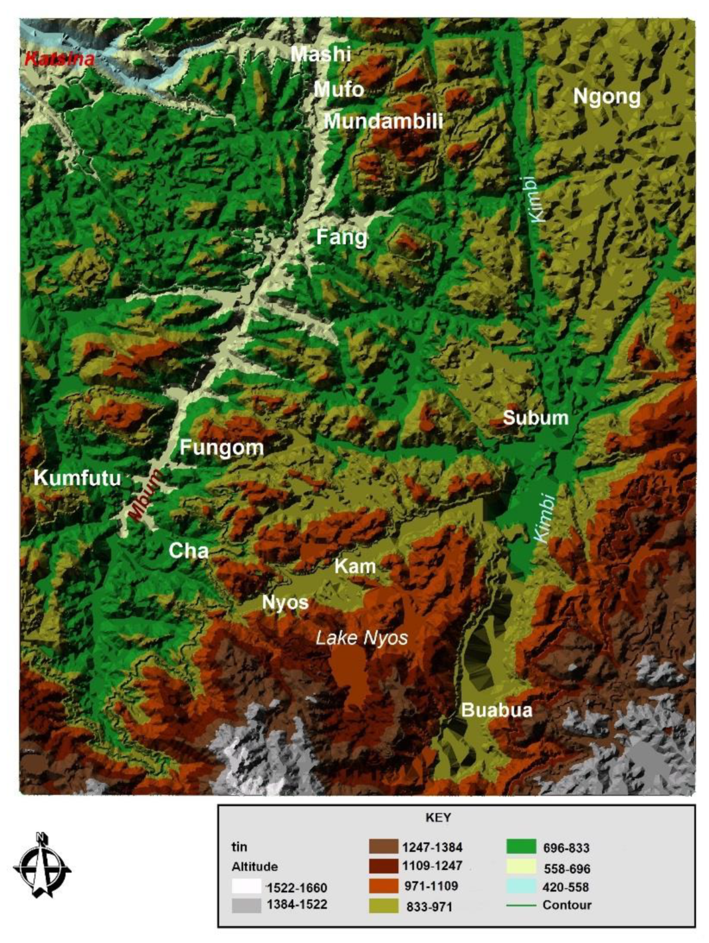
Figure 10.
Lake Nyos pyroclastic dam (from aerial photographs). This dam is only 22 m across and 40 m long.
Figure 10.
Lake Nyos pyroclastic dam (from aerial photographs). This dam is only 22 m across and 40 m long.

Figure 11.
(a) Lake Nyos soil section (source: [2], modified); (b): Drilling on Lake Nyos pyroclastic dam (source: [20,59], modified).

Figure 12.
(a,b) Large potholes are aligned on fractures. These potholes focus on erosion and landslides; (c) mechanical erosion around the dam west flank of Lake Nyos. (Source: fieldwork in April 2007 and June 2001).
Figure 12.
(a,b) Large potholes are aligned on fractures. These potholes focus on erosion and landslides; (c) mechanical erosion around the dam west flank of Lake Nyos. (Source: fieldwork in April 2007 and June 2001).

Figure 13.
Simulation and calculation of flood path (Manning) in case of dam failure at Lake Nyos. (Source: report studies of the security of the Lake Nyos dam [20,59], modified.

Figure 14.
Katsina and Menchum rivers longitudinal profiles. Two main features are recognizable: highland areas > 2000 m a.s.l. located within large volcanic units; and low altitude areas < 1200 m a.s.l. with crystalline bedrock compartmentalized by faults [20].
Figure 14.
Katsina and Menchum rivers longitudinal profiles. Two main features are recognizable: highland areas > 2000 m a.s.l. located within large volcanic units; and low altitude areas < 1200 m a.s.l. with crystalline bedrock compartmentalized by faults [20].

Figure 15.
(a) Overlooking the north end of the dam, where one can observe a deepening of pyroclastic and some consolidated blocks (Source: Hallbwachs et al. [50]). The water flow in the rainy season is 50 m3/s. On the picture with the scarp of 4 m, one can notice that the waterfalls from the spillway dig deeply into the downstream part of the dam and can cause a decrease of the edge by landslides and break blocks within the Nyos valley. These movements may well be added to many other phenomena, such as the evolution of potholes (although the pace of these remains unknown). (b) Mechanical erosion around the west flank of the lake Nyos dam. Blocks 2 × 2 × 0.5 m3 topple into the lake (Source: fieldworks, April 2007). (c) Lateral erosion and progressive retreat of the natural dam of Lake Nyos. (Source: fieldworks, April 2007).

Figure 16.
Lake Nyos degassing process (Source: fieldworks, July 2006).
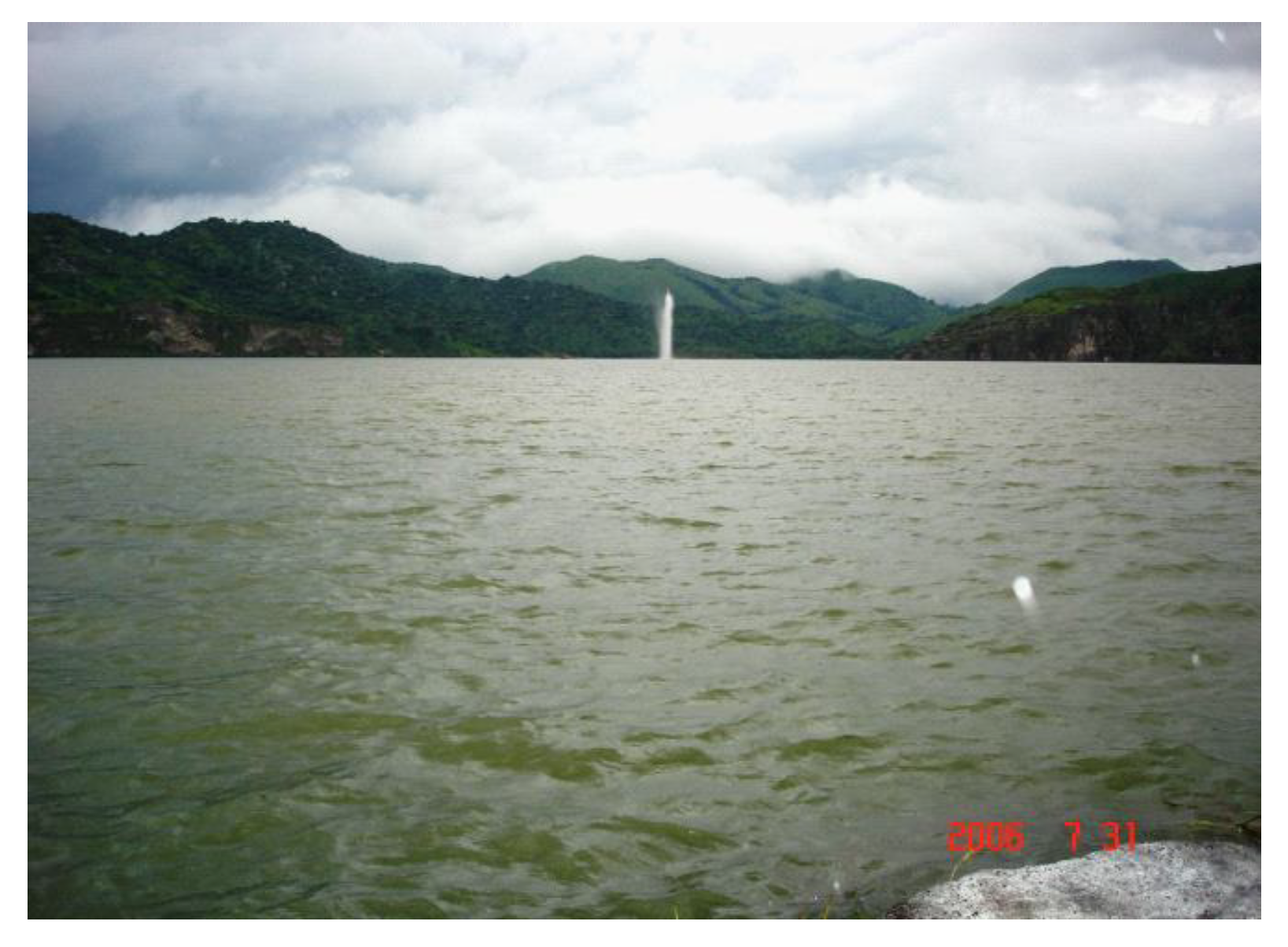
Figure 17.
Lake Mamy Water with water rich in phosphorus. It is pumped by the plantations of Upper Penja (PHP) to water the banana, pineapple and papaw plantations, etc. (Source: Tchindjang, August 2007).
Figure 17.
Lake Mamy Water with water rich in phosphorus. It is pumped by the plantations of Upper Penja (PHP) to water the banana, pineapple and papaw plantations, etc. (Source: Tchindjang, August 2007).


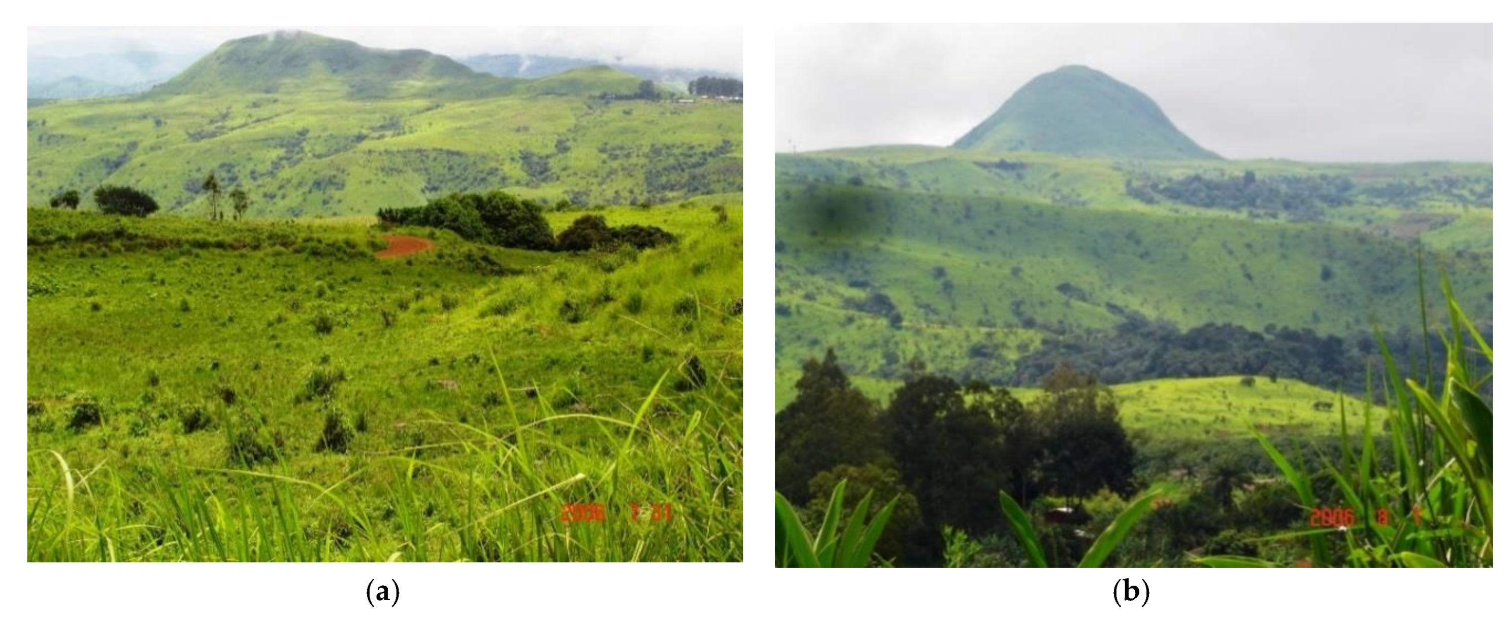
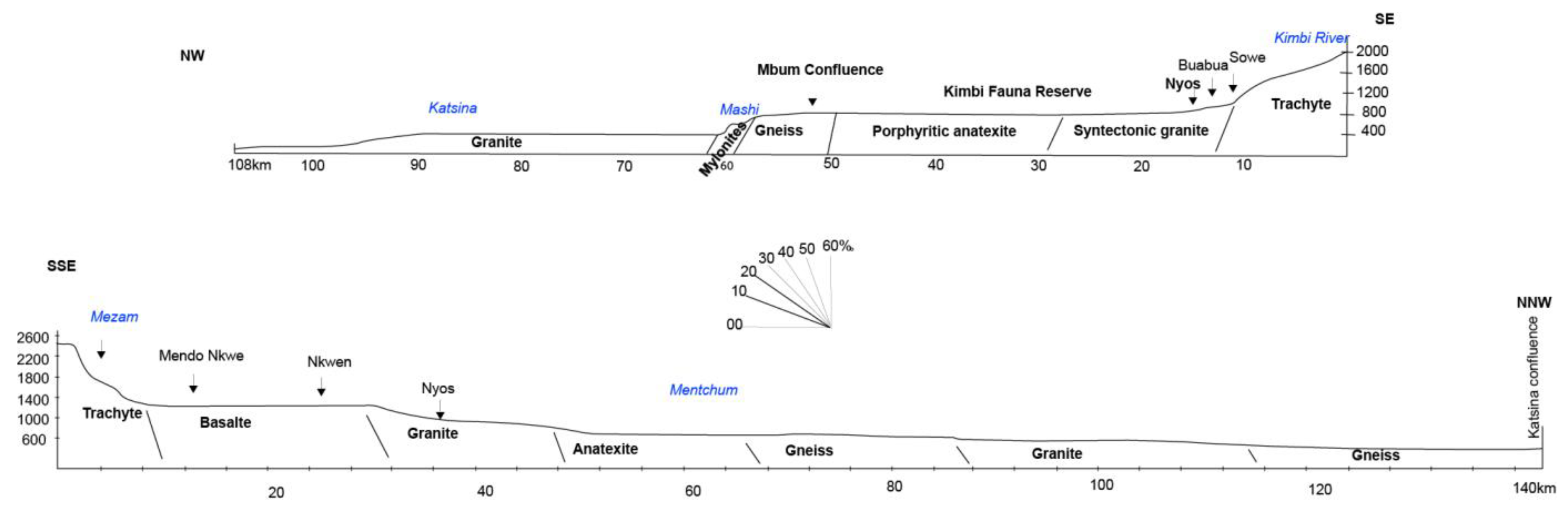
Table 1.
Main components and ranking of the vulnerability.
| Rank * | Structural Damages (P1) | Functional Losses (P2) | Personal Injuries (P3) | Hazard Perception (P4) |
|---|---|---|---|---|
| 1 | Non-structural or light damage, Stability unaffected | No resettlement, no unavoidable change | No injury, no death, no homeless, undisturbed road traffic, very low density travelers | Hazard well perceived and well known |
| 2 | Cracking of walls unaffected stability, non-urgent repair | 1–10 resettlements, no road deviation | Slight injury, no homeless, no traffic disruption, low density travelers | Hazard well perceived and known |
| 3 | Major deformations, walls cracked, structural cracking, evacuation required | More than 10 resettlements, without deviation or deviation of less than 20 km | Serious injury or illness, with or without shelter, large number of travelers | Hazard perceived and poorly known |
| 4 | Fracturing of structures, separation of parts, partial collapse, breach, evacuation, rehabilitation compromised | More than 10 resettlements with road deviation of less than 50 km | Serious injury requiring hospitalization, many homeless, travelers blocked, deviation needed | Hazard weakly perceived and unknown |
| 5 | Partial or total collapse, evacuation, rehabilitation | More than 10 resettlements, with road deviation of more than 50 km | Death, resettlement, deviation for long-term | Hazard not perceived and unknown |
* Rank: 1: very low; 2: low; 3: moderate; 4: high; and 5: extreme.
Table 2.
level of frequency of natural risk.
| Level | Frequency | Indicators |
|---|---|---|
| 1 | Extremely rare | <1 event every century |
| 2 | Rare | 1 event between 10 and 100 years |
| 3 | Nearly frequent | 1 event between 1 and 10 years |
| 4 | Frequent | 1 event every 3 years |
| 5 | More frequent | 1 event each year |
Table 3.
Risk identification matrix or critical grid.
| Frequency | ||||||
|---|---|---|---|---|---|---|
| Severity | More Frequent | Frequent | Nearly Frequent | Rare | Extremely Rare | |
| Very low | 1 | 2 | 3 | 4 | 5 | |
| Low | 2 | 4 | 6 | 8 | 10 | |
| Moderate | 3 | 6 | 9 | 12 | 15 | |
| High | 4 | 8 | 12 | 16 | 20 | |
| Extreme | 5 | 10 | 15 | 20 | 25 | |
Table 4.
Severity assessment of the lake Nyos volcanic hazards.
| Structural Damages (P1) | Functional Losses (P2) | Personal Injuries (P3) | Hazard Perception (P4) | |
|---|---|---|---|---|
| Observed elements | 20 houses destroyed and abandoned | 4434 homeless resettled 3000 cattle killed | 1746 killed 874 survivors with trauma | Hazard fully misperceived and unknown |
| Score | 5 | 5 | 5 | 5 |
Table 5.
Severity assessment of the lake Nyos flood hazard.
| Structural Damages (P1) | Functional Losses (P2) | Personal Injuries (P3) | Hazard Perception (P4) | |
|---|---|---|---|---|
| Observed elements | Many houses should be destroyed, buildings | Thousands of homeless would need to be resettled, destruction of crops, livestock, wildlife, pasture lands | 10,000 to 15,000 death [33] and many traumas, physical stress | Hazard fully misperceived and unknown |
| Score | 5 | 5 | 5 | 5 |
Table 6.
Severity assessment of the lake Nyos landslide hazards.
| Structural Damages (P1) | Functional Losses (P2) | Personal Injuries (P3) | Hazard Perception (P4) | |
|---|---|---|---|---|
| Observed elements | Some houses exposed could be affected or destroyed, no infrastructure to be destroyed by topple or landslide on slope | No homeless, nobody or few people need to be resettled. Possible destruction of crops, road cutting | No injury, no wounded, no trauma, fear, no death | Hazard perceived and poorly known |
| Score | 2 | 4 | 2 | 3 |
Table 7.
Vulnerability index of the main hazards occurring at the lake Nyos before degasing and jet grouting.
Table 7.
Vulnerability index of the main hazards occurring at the lake Nyos before degasing and jet grouting.
| Type of Hazards | Area | Severity | Frequency | Total (Severity × Frequency) | Final Results |
|---|---|---|---|---|---|
| Landslide | Lake Nyos cliff | 2.75 | 3 | 8.25 | Tolerable |
| Floods | Nyos and Kimbi valley | 5 | 5 | 25 | Catastrophic |
| Volcanic, limnic eruption | Nyos valley and surrounding settlements | 5 | 5 | 25 | Catastrophic |
Table 8.
Severity assessment of the lake Nyos limnic hazards after degassing.
| Structural Damages (P1) | Functional Losses (P2) | Personal Injuries (P3) | Hazard Perception (P4) | |
|---|---|---|---|---|
| Observed elements | No house destroyed or abandoned | No homeless no resettlement Possible destruction of cattle | No killed No injury, no trauma | Hazard perceived and poorly known |
| Score | 1 | 1 | 1 | 3 |
Table 9.
Severity assessment of the lake Nyos flood hazard after jet grouting implementation.
| Structural Damages (P1) | Functional Losses (P2) | Personal Injuries (P3) | Hazard Perception (P4) | |
|---|---|---|---|---|
| Observed elements | No house, no building to be destroyed | No homeless, no resettlement, no destruction of crops, livestock, wildlife, pasture lands | No death, no injury, no trauma | Hazard weakly perceived and unknown |
| Score | 1 | 1 | 1 | 4 |
Table 10.
Vulnerability index of the main hazards occurring at the lake Nyos after degassing and jet grouting solutions.
Table 10.
Vulnerability index of the main hazards occurring at the lake Nyos after degassing and jet grouting solutions.
| Type of Hazards | Area | Severity | Frequency | Total (Severity × Frequency) | Final Results |
|---|---|---|---|---|---|
| Landslide | Lake Nyos cliff | 2.75 | 3 | 8.25 | Tolerable |
| Floods | Nyos and Kimbi valley | 1.75 | 4 | 7 | Acceptable |
| Volcanic, limnic eruption | Nyos valley and surrounding settlements | 1.5 | 4 | 6 | Acceptable |
© 2018 by the author. Licensee MDPI, Basel, Switzerland. This article is an open access article distributed under the terms and conditions of the Creative Commons Attribution (CC BY) license (http://creativecommons.org/licenses/by/4.0/).
Share and Cite
MDPI and ACS Style
Tchindjang, M. Lake Nyos, a Multirisk and Vulnerability Appraisal. Geosciences 2018, 8, 312. https://doi.org/10.3390/geosciences8090312
AMA Style
Tchindjang M. Lake Nyos, a Multirisk and Vulnerability Appraisal. Geosciences. 2018; 8(9):312. https://doi.org/10.3390/geosciences8090312
Chicago/Turabian StyleTchindjang, Mesmin. 2018. "Lake Nyos, a Multirisk and Vulnerability Appraisal" Geosciences 8, no. 9: 312. https://doi.org/10.3390/geosciences8090312
Note that from the first issue of 2016, this journal uses article numbers instead of page numbers. See further details here.