Commoditization of Rural Lands in the Semi-Arid Region of Chile—The Case of the Huentelauquén Agricultural Community

School of Natural Sciences, Technology and Environmental Studies, Södertörn University, SE-141 89 Huddinge, Sweden
*
Author to whom correspondence should be addressed.
Agriculture 2018, 8(2), 26; https://doi.org/10.3390/agriculture8020026
Submission received: 15 November 2017
/
Revised: 28 January 2018
/
Accepted: 7 February 2018
/
Published: 14 February 2018
(This article belongs to the Special Issue Localized Agrifood Systems: Governance, Market, and Environmental Issues)
Abstract
:The agri-pastoralist communities of the semi-arid region of Chile, with their unusual common land ownership, have not escaped economic neo-liberalism. The general pattern of insatiable demand of land for agricultural production, mining, energy generation and real-estate development has become a challenge for these communities. How are these processes affecting the traditional practices of these localized agri-food systems, based on rain-fed-agriculture, pastoralism and the fading practice of transhumance? In this article, we look at how the Huentelauquén Agricultural Community in the Canela Commune has dealt with, reacted to, and been affected by regional economic shifts geared towards market liberalization. In particular, we analyze the structural changes in the community in regard to alienation of the commons and changes in land tenure. Qualitative interviews were conducted with key informants in this setting. To provide a richer contextual setting, this article draws on several other empirically-based works on the commons’ emergence and evolution, land commoditization and local struggles for livelihoods. Our study shows that a community can adopt different strategies when dealing with powerful sectoral development that can involve resistance as well as positioning that seeks to find favorable terms of engagement. Our findings highlight that processes affecting the traditional commons are resulting in the re-appropriation and re-occupation of the land. This is resulting in social differentiation, weakening of the community’s social bonds, depeasantization and further degradation of an already vulnerable ecosystem. In sum, these shifts are posing an existential threat to this form of traditional agri-pastoralism.
Keywords:
neo-liberalism; enclosures; commons; transhumance; Chile; development; dispossession; adverse incorporation1. Introduction
The rural coastline and inland of Chile is becoming increasingly valuable as an object of commodification, both for production and post-production activities. This applies equally to lands privately owned and lands held in common. The concentration of land ownership, or control, is a necessity for the expansion of capitalist agriculture [1]. The commons of the agricultural communities (henceforth AC) of Chile’s Norte Chico (mainly Coquimbo Region) have been erroneously identified with minifundium (smallholdings or small peasantry) as “zones for refuge” [2], implying therefore that these areas have somehow been quarantined from the latifundia’s (a large landed estate) hunger for their land. Gallardo’s [3] and Cañon’s [4] studies of the AC in the Canela Commune show the contrary. (A commune (comuna) in Chile is the smallest administrative subdivision). The same is valid for other zones [5]. “Zones for refuge” [2], understood as marginal ecological zones, do not escape the spread of continued economic globalization. To confuse the agricultural communities with the small peasantry (minifundium) is not to recognize their common property as a form of enduring and adaptive land tenure and sociocultural practice that has evolved over a long time. To paraphrase Feder [1], the concentration of land ownership, control or access, is a necessity for the expansion of capitalism in general. The global demand for natural resources poses similar challenges to communities all over the world, regardless of where resource exploitation takes place. Therefore, the insatiable demand for land for either agricultural production or for other economic purposes poses an existential threat to the commons [6].
The necessity to feed the growing global social metabolism of the economy, which constantly drives the expansion of the “commodity frontiers” [7] not only causes environmental problems, conflicts and displacement of people, but also threatens traditional livelihoods. However, this development does not go uncontested by those who see their livelihoods swept away [8] as environmental conflicts increase and grow in magnitude around the globe. Temper et al. [9] broadly define socio-environmental conflicts “as mobilizations by local communities, social movements which might also include support of national or international networks against particular economic activities whereby environmental impacts are a key element of their grievances.” [9].
In Chile, private property dominates between Regions IV of Coquimbo and X of Los Lagos—where most of the population lives. The IV Region of Coquimbo is a semi-arid zone, known as Norte Chico (Little North), in contrast to the Norte Grande (Big North), which is the large Atacama Desert. In the IV Region of Coquimbo, besides differently sized private property holdings, there is also common land. Except for indigenous common land, this is an unusual phenomenon in the structure of land ownership in Chile, where private property is the rule [3].
The agricultural communities in IV Region of Coquimbo, which have historically based their economies on a mix of transhumance of goat and sheep herding and agricultural production, are characterized by the coexistence of common and individual ownership within the boundaries of a land unit. This unit belongs, in a permanent and indivisible form, to all registered commoners (comuneros), who have corresponding rights and obligations in that community (see Table 1). The maximum rights a commoner can accumulate is 3% of the total number of rights. These can be only left to one inheritor. The number of rights cannot increase, but only decrease [3]. Communal land is the key feature of this institution that distinguishes it as a form of property from both private property and open access [3]. To confuse the agricultural communities with the small peasantry (minifundium) is not to recognize their common property as a form of enduring and adaptive land tenure and sociocultural practice that has evolved over a long time. The return of liberal democracy to the country in 1989—after 17 years of military dictatorship—coincided with the formal legal recognition [10] of this peculiar land ownership form.
Besides the common pasture land, the commoners have individual use rights (called hijuelas or goces singulares) to land plots owned by the community. These plots are assigned by the General Assembly of the community to individuals to use permanently and exclusively. If the commoner sells his goce singular, the rights attached to the plot are transferred to the buyer. In such a transaction, the seller loses their status of commoner and with it the prerogatives to have access to the common land and to a third form of temporal use right they can get from the community, called lluvias (land for rain-fed agriculture) [3].
Both sedentary and transhumant pastoralism are key activities embedded into the livelihoods of the agricultural communities and its institutional arrangements. It is widely believed that seasonal transhumant pastoral practices, which are under severe and immediate threat around the world, may provide vital insights into sustainable and biodiversity-friendly food production systems of the future [11,12].
Until a few decades ago, twenty-five percent of the land in IV Region, corresponding to a million hectares, was under a common property regime [3] (see Figure 1 for a Map of IV Region, the southern part is the Choapa province). This situation has undergone substantial change over the past two decades with coastal development involving agriculture, mining, wind energy, real estate and tourism development, and fisheries, among others. How are these changes affecting the coastal agricultural communities? What are the consequences of these myriad development processes for the traditional livelihoods of agricultural communities involving transhumant goat and sheep herding and agricultural production? It should be emphasized that the agricultural communities in IV Region are not homogeneous; some are more agricultural than pastoral and vice versa, depending mainly on the local environment in which they are embedded and their access to irrigation. The scarcity of arable land in the region puts additional importance of livestock production in the economy of the commoners. As Gallardo [3] suggests, this means that the agricultural communities should be considered agro-pastoral rather than agricultural or pastoral only.
In this broader context, the purpose of this paper is to examine landscape changes and their implications through the Huentelauquén Agricultural Community (HAC), which is being subjected to many of the development pressures mentioned above. More specifically we look at how this community has dealt with, reacted to, and been affected by regional economic shifts geared towards market liberalization, with more focused analysis on the structural changes in the community regarding alienation of the commons and changes in land tenure. In the Methods Section, we describe how we collected our empirical data. Then, we elaborate our overarching conceptual frame, which emphasizes how the relentless processes of capital accumulation lead to acts of dispossession and the privatization of communal wealth. We also present a means of understanding how different actors try to position themselves in response to change processes which are affecting the region. This is followed by an examination of the particular expressions these shifts take in the Coquimbo Region. We then zoom in on the case of HAC, where we draw on the experiences and perspectives of local actors to present a rich picture of the role of commons in the agricultural communities and the consequences of recent developments in this community that belong to the Canela Commune, starting the overview from the late 1980s and then focusing mainly on 2000 onward. The implications of these changes are then discussed in a wider setting. Finally, we conclude by presenting our key findings and insights from this study.
2. Methodology
In addition to scrutiny of relevant primary and secondary material, data collection for this paper is based on a series of open and semi-structured interviews with key informants that are commoners of the HAC and the Canela Commune (and its political body the Municipality) conducted between 2013 and 2017. In addition, we engaged with open and semi-structured interviews with other stakeholders to garner additional information regarding the Agua Dulce real-estate project. The interviewed commoners consented to their names being published attributed to the comments they made during interviews. This makes our methodology transparent, which is of special importance given the limited number of commoners interviewed. This approach also allows us to reflect the perspectives and experience of the key informants in a more direct and arguably authentic way. Data considered sensitive have been anonymized.
Our document study draws on primary and secondary sources of government reports, statistics and related sources as well as reviewing theoretical work relevant to the study. Furthermore, this article considers several other works by Gallardo including on the land tenure structure in the Canela Commune (1600–1998) [3,13]; on small-scale fisheries in the same region [14,15]; the commoditization of land and marine resources; and struggles for livelihoods in Chile [6]. These works are based in extensive empirical work undertaken in the area since the 1980s.
Key informants were selected from the HAC because they possessed specific information regarding the HAC and its land subdivision processes. They were: (1) L. R. Ibacache, a herder, farmer and algae collector who on a daily basis, traverses a broad geographical area of the HAC by horse. Being a herder, he is also knowledgeable about the existing number of cattle in the community where ca. 170 of 343 commoners are active—only a small number of commoners have cattle. (2) M. Trigo is a commoner who occupied a position as a former secretary of the HAC Board. She acted as intermediary facilitating land sales after the second 1999 land alienation. As a result of this, she is unique in her knowledge about most of the local land transactions.
The information obtained through several years (2013–2017) of both open and semi-structured interviews with Trigo and Ibacache was complemented through open and semi-structured interviews with the two key informants from the Municipality during 2013 and 2014. The accumulated and validated knowledge from these four key informants (commoners N. Trigo and S. Ibacache in addition to Narvaez and Cortés from the Municipality) formed the basis of further semi-structured interviews held with a local teacher (Ollarzú) and the former mayor of the commune (N. Trigo). Ollarzú, the teacher, has worked for 45 years in several schools in the commune and the province. He thus possessed a broad experience of changes that have taken place over this time. N. Trigo was Mayor of the Commune twice (2004–2008 and 2008–2012). In other words, we undertook semi-structured interviews that varied between informants. The semi-structured interviews with Ollarzú and N. Trigo illustrate the range of questions raised in interviews with the four informants mentioned previously (see Appendix A). These understandings were also triangulated through document analysis.
The key informants from the Municipality were selected due to their formal positions as the head of Public Works of the Commune and former lawyer; they were either aware or involved in the structural changes taking place in the commune and associated legal processes. The lawyer currently works in a commercial practice representing private land owners seeking land compensation related to infrastructure development in the Commune. Other stakeholders were consulted on matters concerning the Agua Dulce real estate project during 2013, 2017 and 2018. Table 2 presents the interviewees, type of information sought and methods used. Details of the questions used to interview the teacher and former mayor are specified in the Appendix A.
3. Conceptual Framing—Accumulation by Dispossession and Adverse Incorporation
The material flow from rural areas towards the national and global markets exacerbates the metabolic rift [16,17,18], which started during the colonial period and continues today under renewed processes of capital accumulation [8]. Harvey [19] proposes an update of Marx’s classic concept of “primitive accumulation” to “accumulation by dispossession”. He describes it as the privatization and commodification of public and social wealth, in a process driven by neoliberal policies and globalization. In these processes, Harvey [20] includes land and sea tenure which are redefined through grabbing processes, thereby threatening traditional forms of production and consumption. Present accumulation by dispossession processes is also taking place where livelihoods are managed under open access, state or common property and in lands of low agricultural value (so called marginal lands), or in dry-land zones. These attributes apply to the case we discuss here. The semi-arid land of Chile’s Coquimbo region is defined by some scholars as marginal or low-quality land, especially the area belonging to the agricultural communities [21]. Nonetheless, what in one historic moment is marginal land for agricultural purposes, in another moment becomes “revalued” and ripe for reproduction as new technology works to remediate former production constraints or where scarcity of land/resources might make, what was once marginal, profitable.
Global capitalism, works progressively to dispossess or subsume small to medium size landholders/producers to facilitate access to land for large-scale mining or agricultural production activities. This is because capital perpetually searches for new frontiers in which to extract resources and products and to transfer optimum rents through liberalized global markets. This process has the concomitant effect of displacing landholders/producers while at the same time creating socio-environmental conflicts from the extraction of resources to the disposal of waste [9]. Under these conditions, this dissociating process allows free material flows between the local and the global [22], cleaving metabolic rifts between humans and the environment generally and between different parts of the world—most emphatically between rural and urban locations [16]. Even though extraction, production, consumption and waste take place in various places around the world, these processes are intimately connected with each other; all being part of economic globalization. Thus, there is a dialectical relationship between capitalist expansion on one side and predatory practices of dispossession and environmental destruction on the other side [18,23]. While we share the conception of the broader processes of capital accumulation described above, we agree with Hall et al. [24] that we need greater empirical understanding of how these processes occur in particular contexts. To do this, we needed to pay close attention to the range of interactions between “land deals” and other resource interventions and the diversity of “reactions from below”.
Dispossession itself can take place through violent mechanisms [25], but also through more subtle processes of engagement and enrolment in “land deals” that might or might not constitute resistance and/or dispossession [24]. Our focus here is on the HAC commoners’ reactions to multiple and diverse land deals and resource conflicts. In our study area, the sheer variety of sectoral interests and their interaction provide fertile empirical ground to examine the range and complexity of the micro political economy of land and resources. In engaging with such empirical complexity, we acknowledge that these land and resource deals take different forms and have differentiated effects on social groups within communities. In some instances, there may be clear signs of organized resistance as traditional resource rights holders seek to defend their entitlements through direct actions, while, in other cases, interaction might be seemingly consensual. Hall et al. [24], in an introductory article in a Special Issue on land grabbing in the Journal of Peasant Studies, drawing on Hickey and du Toit (2007), propose the concept of “adverse incorporation” to understand why some actors seemingly voluntarily consent to land and resource deals that appear to work against their own interests. This concept highlights the paradox of the invariably exploitative character of such relations even when people seek inclusion in them. That is not to say that some actors do not benefit in any way from their incorporation into the land and resource deals of others, but it suggests that “incorporation”, even on less-than-adverse terms, does not challenge the overarching direction of agrarian change or the globalized structures of capital accumulation within which it is located [24].
While our overarching engagement with the experience in the Coquimbo Region is framed in an accumulation by dispossession perspective we also look to capture the details of these processes by drawing on the thinking captured in “adverse incorporation”. That is, we examine land, resource and infrastructure projects to understand how commoners have negotiated the terms of their incorporation, including capturing struggles of resistance where they are apparent.
4. Regional Level: Changes Affecting the Coquimbo Region—A Sectorial Overview
4.1. Agriculture
The increasing demand for land in the Region was triggered by the agricultural boom of the 1980s driven by a neo-liberal policy that stimulated agricultural export [26]. Since then, stimulated by this export orientation, the agricultural frontier in the IV Region has expanded through the continued modernization of agricultural techniques, importantly including irrigation. The irrigation system has been steadily expanding in the Region since the 1960s [27,28] to the extent that now it includes several dams with a combined Regional capacity of 1025.5 million cubic meters of water. During this period, water rights were privatized. This system irrigates 40,000 ha, making the permanent cultivation of grapes for export possible [29] in the Limarí Province, which includes almost 70% of the agricultural communities of the region [30]. The 1981 reform to the Water Code [31], undertaken under Pinochet’s dictatorship, dissociated the right to the water from the right to the land [32]. The implication of this was that water became a market commodity that could be appropriated for purposes other than agriculture, i.e., for mining, urban development, etc.
The agricultural communities have been actively involved in this commodification of land trend, through the production of agricultural produce for domestic and international export and/or through engaging in various contractual arrangements with agribusinesses. The latter process has taken several forms, including the leasing of land and contract farming.
Looking at the dispossession of common lands mechanisms in the Region, Duran and Livenais [28] analyze how the so-called agro-industrial complexes for export have inserted themselves within the agricultural communities. This study focused on the Limarí Province (Huatulame river valley) in the IV Region of Coquimbo between 1983 and 2003. Agro-business, which did not exist before 1982, had by 2001, acquired ownership of more than 50% of the agricultural area [28] in the valley. This occurred while the agricultural communities reduced their participation in land ownership. According to Duran and Livenais [28], this took place through two appropriation mechanism: (1) some commoners sold their goces singulares, with or without the corresponding rights attached to them, and without the approval of the agricultural communities General Assembly (i.e., against the agricultural community’s regulations); and (2) the agricultural communities General Assembly distributed new goces singulares to the commoners, who sold them, with or without rights. Likewise, Duran and Livenais [28] found that new requests are constantly submitted by outsider sectoral interests to General Assemblies to acquire new land across both communities studied.
The change in production that follows from leasing of land and contract farming is not just based on the separation of the producer from their means of production but it deals with a process where global capital introduces “in different regions, different forms of labour for different types of production” [33]. The agricultural communities can also collectively choose to alienate part of their commons. To take the decision to alienate part of their common lands, communities need a quorum of two-thirds of the commoners gathered during a General Assembly [3]. What is interesting about this last course of action is that it implies processes of primitive accumulation. That is, in general terms, without detailing each transaction to understand the terms of land deals that the communities are confronted with, the commons are progressively enclosed through individualized tenure, dispossessing the commoners. Looking at the terms of incorporation of commoners in land deals and where benefits have flowed over time will provide more nuanced insights into the actions of actors involved and the extent of disadvantage suffered.
4.2. Mining
Mining for export has historically played an important role in the Chilean economy, IV Region, included. In 2014, thirty per cent of Chile’s export value came from metals [34]. The importance of mining throughout the country is closely aligned with the need for infrastructure projects to support mining activities, such as thermo-electric plants, water engineering schemes and ports to transport mining deposits. Even if the mining itself is not always the focus of conflicts, the associated infrastructure development often is. Known examples of large conflicts are the copper-iron mining project La Dominga in the Higuera Commune [35,36] and the even larger conflict between the copper mining company, Los Pelambres and the Caimanes community in the Choapa province (IV Region). It was reported recently in the news that the La Dominga project “failed to secure its environmental permit, after the Regional Environmental Evaluation Service (SEA) of Coquimbo region (IV) voted it down.” [37]. This issue led the Ministers of Finance and Economy to resign after the La Dominga crisis [38]. The latter project involved a long enduring conflict [39], which recently came to end with the Caimanes community receiving US$36 million in compensation from Los Pelambres [40]. A new, relatively large-scale copper-gold mine (El Espino of the Sociedad Punta Del Cobre-Pucobre) received permission in December 2015 from the SEA to start exploitation in the Choapa Province (between the border of the Canela and Illapel Commune) [41].
Resource-based conflicts are increasingly common throughout the country. The National Human Rights Institute (INDH) [42] identified 102 socio-environmental conflicts in Chile in 2015. Some of these environmental conflicts are taking place among small-scale peasantry and within agricultural communities and creating social rifts within these communities. Whether resource projects are locally supported or opposed affect how these conflicts play-out and the extent of the social schisms that accompany them (which may also imply networked connections with other actors operating at larger scales whom local actors finding mutual interest with in their support or opposition to land and resource projects).
4.3. Real-Estate Boom, Tourism and Recreational Housing
The coastline is increasing in land value due to significant investment flowing from the growing economic power of a wealthy middle and upper class, driving private and commercial development to meet recreation and leisure demands. This type of post-production interest in land-use takes several forms. The gross domestic product (GDP) per/capita in purchasing power parity in current priced international dollars for Chile increased markedly from US$3432 in 1980 to US$11,238 in 2000. By 2016, it had ballooned to US$24,089 [43].
First, there is an increasing demand for recreational housing through the acquisition of the so called parcelas de agrado (private rural recreation plots). The law restricts the size of these plots to 0.5 hectare and they cannot be further sub-divided [44]. The recreational housing interest (summer, holidays and weekends) takes at least two forms: (1) high quality holiday houses for middle to upper middle classes; and (2) lower quality holiday houses for lower income strata. Well known examples are exclusive enclosed resorts such as Las Tacas, Puerto Velero, and Totoralillo, to which it sums up now Agua Dulce in Huentelauquén.
Second, there has been the development of infrastructure to meet the growing needs of seasonal tourism and short-term visits to the Region’s beaches, coastal areas and marine national parks. This includes the proliferation of campsites and hotels, and ancillary infrastructure, all of which contributes to placing additional pressure on the semi-arid environment that characterizes the Norte Chico [6]. Another factor related to the rise of the value of the coastal land and the two types of developments discussed above, is the growing phenomenon of outsiders—commonly coming from urban areas—acquiring commoners’ rights within the agricultural communities, a cheaper non-market or backdoor way to get access to coastal lands.
4.4. Fisheries
Fishing development in the country, both artisanal and industrial, has also strongly affected the coastline. The internationalization of food systems [45] has greatly contributed to this development [14]. Two modalities of fisheries development are: (1) the implementation of the AMERBs (officially called Areas de Manejo y Explotación de Recursos Bentónicos or MEARBs in English, which stands for Management and Exploitation Areas of Benthic Resources), most commonly known internationally as territorial use rights for fisheries (TURF), which have expanded along the coast to protect benthic resources and benefit small-scale fishers; and (2) the expansion of aquaculture; either by private large scale and/or intensive production export firms, or more recently through low intensity collective production within the TURFs.
These activities have led to competition for access to and use of the coastal space with other economic activities and social actors [15]. Until now, little or no fishing infrastructure has been developed to support the viability of TURF communities along the coast in private lands. However, there has been mounting pressure for this to change [14] which has recently been successful. A new law, which regulates the harmonious and integral development of the 461 existing coves in Chile, known as “Caletas Law” [46], aims to strengthen the productive, economic and social capacities of artisanal fisheries organizations in coastal spaces. By obtaining an agreement of use, fisher organizations will be able to apply for a concession to the coves for a period of thirty years [47]. Fishers use as operational base for their MAs [TURF] coastal places named “caletas”. “A caleta is a small-scale fishing port, mostly located on a protected coastal site (the cove), involving the pier (when there is one), the boatyard, the huts or sheds in which fishers’ camp or the associated houses or community in which the fishers live. Access or entrance to the coast for artisanal fishers varies depending on whether the caletas are situated on municipal/state or privately-owned land.” [15].
In the case of the Canela Commune, most of the landing coves or ports (caletas) of the TURFs are within private properties—either haciendas or fundos. While some fisher organizations in the region have obtained the commodatum (a determined use right agreement from with the owner of the land) of the coves, other fishers have had ongoing access problems to their TURF [15]. In any case, TURFs presently cover most of the caletas or fishing “ports” associated with artisanal fisheries in the Region.
4.5. Wind Energy
The development of parks to produce wind energy off the coast of the IV Region from the 1990s has rapidly bought about both socio-economic and landscape changes. The Canela Commune has become a pioneer site for wind energy production, which has attracted leading international companies with significant investment capital to the area.
Although wind-power farms were eventually placed on private lands, there was interest to locate them on the coastal land of some agricultural communities. The creation of these parks is significant for economic growth and employment in the commune. This is a commune that has historically been among the poorest 10% in Chile. That said, the windfarms and related development have also contributed to higher prices not only for leased housing, but also for the land prices along the coast. In the first half of 2009, the Canela Commune raised nearly US$165,000 from patent concepts, which exceeded the commune patents revenue earned during all of 2008 [48]. According to our calculations, in 2014, the commune should have received about US$303,000 for the three parks located its area. In 2011, in the Canela Commune, 59.6% of its inhabitants were classified as being in poverty; in 2013, this figure had reduced to 37.5% [49].
All the sectorial development processes discussed in this section (agriculture, mining, real-estate boom, tourism and recreational housing, fisheries and energy wind) have been and are continuing to affect the HAC, however, we focus mostly, but not exclusively, on processes and interactions related to real-estate development and mining.
5. Local Level: Dismantling the Commons of the Huentelauquén Agricultural Community
This section details significant changes that have and are currently affecting the HAC operating at different spatial and temporal scales. In particular, we examine real-estate development, a mining concession (and attempts to exploit it), a wind power development proposal, as well as fisheries development and access to the coast. Each sectoral development process has its particularities, but when taken together they constitute an example of the ongoing socio-economic and landscape transformation of the region. However, before we describe these changes, we give a short overview of HAC history.
5.1. Historical Context—The Huentelauquén Agricultural Community
The HAC emerged from the La Canela colonial cattle ranch. In 1705, the owner Diego Pérez Cortés left the ranch to his two sons, Pedro and Diego Castillo Cortes. In 1726, Pedro Cortés Castillo, before dividing the ranch with his brother, sold the Huentelauquén lands. This area corresponds to the coastal area from the north shore of the Choapa River to what is now the Talinay fundo, located about 10 km north of the Choapa River—which now corresponds to the location of the current HAC (approximately 7426 ha) [3]. (See Figure 2, where the location of HAC in the map corresponds to nr. 137 in the southern part of the map indicated as Choapa River). For the history and development of the land tenure structure of the Commune [3].
In 1986, the HAC consisted of 7426 ha (comprised mostly of dry-land) and 343 commoners. The Huentelauquén village had a population of 1050 inhabitants. Ten families were non-community members. Of the total of 343 commoners with rights, 200 (58%) lived in the agricultural community [3]. In 1986, there were 3200 sheep and goats, 400 cows and 600 horses [3].
Today, according to one informant, about 50% of the commoners live in the community (Ollarzú Interview). Of these, about 100 commoners engage in agriculture production in the fertile lands near the river (Ibacache Interview). A few commoners own up to 20 ha in this sector. There are also approximately 52 goat and sheep herders, who have around 400 goats and 100 sheep between them. There are also about 100 cows and 200 horses. Some commoners are also engaged in algae collecting. Five commoners have licenses from fisheries authorities and around twenty-five other fish without licenses. Another group of ten commoners own additional private agricultural plots of between 6 and 10 ha in the former hacienda of Huentelauquén (Ibacache Interview), which was expropriated during the 1960s [3]. These private plots are devoted to the production of avocado and corn, among other things.
Comparing this information derived from Ibacache, with the numbers from 1986, three types of key shifts are evident: (1) the number of absentee commoners has slightly increased; (2) there is a greater diversification of livelihoods within the community including algae collection for markets, which is relatively new; and (3) cattle numbers appear to have declined sharply. The reduction in cattle numbers is also reflected in regional statistics between 1975/76 and 1996/96: −38.1% cattle, −60.1% sheep, −74.4% pigs and −21.9% goats [24]. A key factor that affected the decline of cattle numbers was a significant drought, which has plagued the area since 2008. As of February 2014, the region remained in the state of hyper-aridity [50].
5.2. Real-Estate Development
5.2.1. The First Alienation of Common Lands for Real-Estate Development
During this period (1986–2016) one of first developments that affected the HAC was the growing wave of real estate, recreation and tourist projects. In 1995, the agricultural community through consensual agreement sold 352 ha of common lands (See Map B, Figure 3), which encompassed the Agua Dulce sector (known as Agua Dulce beach), thereby reducing the community’s landholdings to 7074 ha [3]. The sale was worth 500 million pesos (US$1260 million). This consensual alienation of the common land required a legal quorum of two-thirds of community members, in accordance with Article 49 of the 1993 Act on agricultural communities, Law no. 19.233 [3]. According to a member, very few opposed the deal (Ollarzú Interview). Of the total received for the sale, ca. US$1 million was evenly divided between commoners individually, while the rest (ca. US$252,000) was put into a community fund (Ibacache Interview). Ibacache (Interview) and Ollarzú (Interview) describe how the commoners used the proceeds from the sale in various ways. Some members spent it on house maintenance, others paid back-payments on community dues, a few bought cars and we were told, “others wasted the money”. Of the ca. US$252,000 that went into the community coffers, half of these funds were earmarked for a debt the community owed to a company for the construction of a dam for irrigation that did not come to fruition due to poor construction (Trigo (b) Interview).
One consequence of this land alienation was that the new owner closed public access to the Agua Dulce beach for more than decade. This act attracted widespread condemnation and direct action, but despite several public protests (involving the inhabitants of the entire Choapa Province) and interventions by municipal and regional authorities, the beach access remained closed. On one occasion, locals forced their way onto the beach in a convoy of cars and trucks. The police force was called and the Region’s peak authority (Regional Superintendent) had to be called in to mediate the peace.
The new owner of Agua Dulce, bought the land with water rights in addition to the right of way or easement (paso de servidumbre) (Trigo (a) Interview). It was only in late 2011, 17 years after the purchase of land from the community, that Agua Dulce was sub-divided into 337 private plots of 0.5 ha each (Spaolonzi pers. communication) (See Map A, Figure 3). These were advertised as “exclusive beach, parks, landscaping with native vegetation, all developed by a landscape architect...” [51] (pers. communication). Moller [51] stated in a letter of response to a potential buyer, “We are beginning a stage of sale with recommended people”. This makes it clear that only “selected people” were invited to purchase the properties for sale. In 2013, it was expected that the price of the most expensive land parcels would rise to US$89,000. Far exceeding this expectation, during 2018 the plot prices ranges, depending in the position towards the beach, between US$410,000 and US$77,500 (Spaolonzi pers. communication). The Canela Municipality is responsible for regulations regarding construction. The real estate developer has submitted to the Municipality the documents for the construction of a hotel, housing and an access gateway (Narvaez Interview). It is also noteworthy that the Municipality would be able collect taxes from the development upon completion.
Additionally, the owner wanted the water provision for the sub-division development to come from the nearest river via community lands, but there was strong resistance from the community on this point. The land sale from 1995 specified that the path the water pipe would traverse from the river to the Agua Dulce sector (ca. 10 km. distance), via the Panamerican Highway. The owner of Agua Dulce seems to have bought a commoner’s goce singular without the right attached to dig a few water wells, from which he has drawn pipe water to support the development of his real estate project (Ibacache Interview, Ollarzú Interview), although this is far from adequate to service the entire development in the long run. New negotiations with the community allowed him to draw the line near the coast for US$611,000 (Ibacache Interview). The owner threatened to shoot a herder’s goats next time they entered the property to feed on pasture. The effect of this land being alienated from the community’s communal lands is a reduction of the common fields for grazing of cattle on which several commoners depend on and in doing so placing extra burden on the rest of the common fields [3].
The coast is, by definition, a national public good [52], but the public do not have access to coastal beaches if they are totally enclosed within private property, so in 2015, when the beach access to Agua Dulce for the public was restored, it was widely celebrated as a triumph by locals as can be seen in Figure 4. (It is common that the physical boundaries of private property, backed by colonial title deeds, reach the sea. In these cases, the area of public beach extends only eight feet above the high-water mark, while in the state-owned public land, the beach area is eighty feet above high-water mark [52]. Between 2006 and 2008, there were 151 cases of reported problems with access to the beach through private property in Chile [53].
5.2.2. The Second Alienation of Common Lands for Subdivision as Private Rural Recreational Land
In 1999, the HAC alienated a further 174 ha of the common land on the coast adjoining Agua Dulce towards the Choapa River in the South. With this alienation, the community area was reduced to 6900 ha. On this occasion, the commoners subdivided the land into 348 plots of 0.5 ha. The 343 plots were assigned to the same number of commoners. In this way, these parcels became private property and therefore individually alienable. The remaining five plots were kept as common property for the community and as such can be sold to raise common funds for the community in the future. Some commoners have kept their plots, while others have sold them. As of January 2013, of the total 343 private plots, 193 (or 56%) plots were sold (Trigo (a) Interview).
Plots were allocated to individual community members through a lottery; leaving to chance how the plots were distributed to commoners (some were close to the beach and therefore of higher value, others were inland and of less value). There were families which got plots for both husband and wife if both where commoners. The plots nearer the shore were valued at around US$14,000 in the late 1990s. The current valuation is estimated to be US$35,000. Currently, some blocks with spectacular views of the sea are being offered at double this price (Gallardo Interview).
Of the 193 plots that have been sold, on about 90, individual houses of middle class standard or above been constructed. There are about another 60 houses that have been constructed on additional subdivided plots. There are also illegally constructed individual houses and subdivisions called “witch divisions” (loteos brujos) (Narvaez Interview).
There are ongoing utility provision concerns in this housing development. The summer house owners are required to pay for water provision. There is not a proper gathering place and treatment of waste generated by these houses. The Municipality collects garbage in a special spot located in the middle of a community settlement, which creates a public and environmental health problem (Narvaez Interview). State rules also demand that rural recreation land for sale is supported by a minimum level of infrastructure, but this is not the community’s (as the vendor) responsibility.
Undoubtedly, the development and construction activities have generated incoming funds for the community and the commune. This is in addition to the income that flowed to some commoners from the plot sales. That is, from the individual 139 commoners’ plot sales, around US$2.5 million (ca. US$18,000 per plot) would have benefited more than 55% of the commoners.
5.2.3. Acquisition of Commoner’s Rights by Urban Outsiders
Another process that has affected the HAC is the interest of outsiders in acquiring commoners’ rights; a process that is likely to be related to the rise in value of the coastal land. According to Ollarzú (Interview), the rights acquired by people who are not community members totals 43 land rights, corresponding to 12.5% of the total number of rights. Despite not living in the community, outsiders are disproportionally represented in the elected HAC Community Board. This board is responsible for steering and implementing community decisions
A review of the seven members of the Community Board in January 2013 shows that the three (out of six) key positions are in the hands of new commoners. This includes the current president who became a commoner by buying her right and the treasurer who does not live in the community but became a commoner by inheritance (Trigo (a) Interview, Ollarzú 2014 Interview).
5.2.4. New Ongoing Subdivisions of Common Lands
The allotments of common land in the HAC continues through two key mechanisms: (1) as strategy to protect the community’s coast line; and (2) as a measure of economic entrepreneurship fueled by the growing real-estate development caused by the sale of recreational plots of Agua Dulce and the 1999 allotments.
The community is engaging in these ongoing subdivisions. First, by providing rights to its 343 commoners in the form of land plots of 1000 m2 (25 m × 40 m) in the coastal part of the community apparently in part to block the mining company Siglo XXI’s mining operations and to get their own plots near the coast (see Section 5.3). This has resulted in dismay and anger from the outsiders (including summer house residents) that bought plots at higher prices with the promise of securing first line plots to the sea (Irarrázaval Interview; Ibacache Interview). Some of these house owners are taking legal action against the HAC (Ibacache Interview). They have formed a Neighbor’s Board that has hired a lawyer to try to reverse this process (Irarazaval Interview).
The HAC have also requested ten mining concessions in the dunes “to protect us” [56] from the mining company Siglo XXI or other mining interests (Ibacache Interview). On these sites, the commoners could, if they so desired, build private bungalows for their own use or lease to tenants. In this way, any mining company that wishes to exploit the dunes in the future will have to individually negotiate with each owner, which according to Ollarzú is likely to hamper mining access (Ollarzú Interview). In the worse of cases, it also opens a flank to a de facto privatization if there are individual commoners who are seduced by other private interests. In other words, this strategy may end up being a double-edged sword that could backfire on the HAC.
In the second allotment, the community is allocating one ha. to each commoner in the form of individual goce singular on both sides of the Pan American highway, where the commoners can establish restaurants, food services, etc. to attract trade from passing traffic (Ollarzú Interview). Goce singular as a land tenure form is alienable but with a commoner’s right attached to it, which means that if the commoner sells he/she ceases to be a commoner. With these new repartitions, the tenure of the goces singulares is further changed and made more complex. Historically, a commoner would have one goce singular, but now some have three and in different locations and not longer for agricultural purposes. If a commoner decides to alienate his/her commoner’s right, would that imply he sells the three goces singulares with the right? With both new allotments, more than 400 hectares of common land became commoners’ individual tenure.
5.3. Mining Development, Conflicts, Environment and Cultural Heritage
Mining has also affected the HAC. It is an intricate issue, which has resulted in diverse types of conflict, among different actors, as well as, legal wrangling as the dispute has been subjected to convoluted legal processes.
The Siglo XXI mining company was allocated a mining concession of 621 ha within the HAC [57] in the sand dunes located on the coastline in a sector called Las Ventanas. This is situated near the mouth of the Choapa River, where the wetland of Huentelauquén is located [58]. We were told that an ex-president of the HAC Board supported the mining company’s project to extract iron without the required approval of the community assembly (Trigo (a) Interview). The project also involved establishment of a processing plant to extract the iron from the sand. In 2012, the same ex-president of the HAC also withdrew a community-backed appeal by the HAC to the Court system against the mining going ahead. He was subsequently deposed by the community in 2013 (Trigo (a) Interview). He was an outsider who became a commoner via his grandparents.
The HAC sought to resist the mining operations. A newly elected Community Board rejected the mining project and the dispute was first referred to the Court of Los Vilos (Case Sociedad Minera Siglo XXI versus Huentelauquén) and then through appeal to the Supreme Court of Chile. A lawyer acting for the HAC cited ecological reasons for rejecting the operations: “because the damage that it is going to cause is much more and there is ecological damage that has no price” [59]. According to CIPERCHILE (an investigative journalist center) [60], the Court of Los Vilos made a judgment in January 2013, which blocked the installation of the company’s infrastructure because the proponents had not the required environmental permits. A document developed by the Agricultural Livestock Service (ALS) [61] notes that the extraction of ore from this project would not exceed 4000 tons per month. Because of this, the company did not need the aforesaid environmental permits. This is also a point highlighted by the Service of Regional Environmental Assessment (Letter 0257, 2012), where it states that the regulations require such a submission (for an environmental permit) to the AIPS only if the extraction of ore is greater than the 5000 tons a month [61].
On the other hand, the Ministry of Environment of the Coquimbo Region [62] points out that the “the area of location of the project has a Regional Zoning, which classifies it as Protected Area, in addition to its Communal Zoning as Area of Nature Conservation” [62]. Therefore “the entrance of the project is required to be subjected to Environmental Impact Assessment” [62]. This interpretation was rejected by the company along with additional compliance arguments made by several other regional authorities [63].
In the dispute, Corporación Nacional Forestal (CONAF) joined with the Ministry of the Environment of the Coquimbo Region, pointing out that given the large number of hectares that the project covers, the “situation deserves an expert report which considers the projections of the effects that it would have upon the entire ecosystem of dunes and its environment” [59]. The presence of the dunes is important for the protection of the coastal land adjacent to the dunes. By removing the minerals from the sand, it would more easily be displaced by the prevailing south-east winds that hit the shore. The dunes also serve as a protective barrier against tsunamis [64]. The displaced sand would likely be dispersed, deleteriously affecting the common fields as well as the commoners’ residential areas and summer houses. The summer house residents supported the community in its fight against the mining company (Irarrázaval Interview).
The national media, Radio Cooperativa reported that during 2013, the community organized two public protests (severely disrupting the traffic of the Pan American Highway) against the Siglo XXI mining company, but also against Pelambres, which according to the commoners, contaminates the Choapa River.
Figure 5 shows the anti-miming protests that were held during July and September in 2013.
The community seems to have developed, and is developing, several other defense strategies to deal with mining encroachments and other interventions from outsiders, in addition to those mentioned in Section 5.2.4. In 2011, the wetlands were granted formal protection and hunting was prohibited. This protection measures were the result of a cooperative effort between HAC, the University of La Serena, the Canela Municipality and the Ministry of the Environment and Agriculture of Chile [67]. The Huentelauquén wetlands has also been proposed as a Ramsar site [68] and if it were to be listed it would receive protection under the Convention on Wetlands of International Importance [56]. Furthermore, the wetlands have been proposed as a “sanctuary of nature” [56]. Supporting these increase protection initiatives, the wetlands have been defined by the scientific community as a “priority site for biodiversity conservation” and an “area of scientific interest” in the Coquimbo Region. This widespread recognition of ecological values of the wetlands is based on the diversity of native flora and endemic species that are found there. In 2015, the Ministry of the Environment formalized the declaration of the Las Salinas wetland of Huentelauquén as the 13th Ramsar Site in Chile [69].
The mining company left behind a degraded site and waste material (Ibacache Interview). This struggle is not finished. In 2014, the mining company applied for a new mining project, with a related environmental impact assessment declaration, to the Service of Regional Environmental Assessment (SEA) [70].
Pichara, another mining company, is exploiting the sandbanks in the sector. This company is in a cooperative relationship with the HAC (Trigo (a), Interview). The operation commenced four years ago and occupies 12 ha. The company pays US$449 a month to the community (Ibacache Interview).
5.4. Enclosure of the Public Beaches and Access to the Coast
The HAC owns the land up until the high-water mark, which gives it de facto and de jure rights to exclude others. Therefore, the community, with recourse to environment and health regulations, closed access to the coast to avoid the public camping on the beach due to the lack of basic infrastructure such as water, bathrooms and appropriate places to dispose of the trash. From the summer of 2009, restrictions on access to the coast have been extended to all fishers that are not from Huentelauquén.
The privatization of all common land that the community has alienated has meant that access to coastal beaches has not only excluded other fishers, but also the general public, except those who have bought land plots or built summer houses. Those with fewer resources lost access to the beach. As a local solution to this situation, the Canela Municipality leases coastal land from the HAC during the summer months (Trigo (b) Interview). By doing this, the Municipality ensures public access to the beach to its inhabitants, thus offsetting, to some extent, the loss of Agua Dulce as public beach in 1995 when the new owner closed access to the beach. The lease costs the Municipality more than US$5000 for the summer season plus the costs of road maintenance and those associated with the provision of basic camping services (Cortés Interview).
In closing access to the beach, the community acted in a similar fashion to some large private landowners, where fishers have experienced access problems to their fishing grounds [6,15]. This local process is another example of the struggle for natural resources, but in this case between groups occupying a similar social position [6].
5.5. Wind Energy Development: A Frustrated Project
Another project that adds to the entire development trend and relatedly community dynamics that we have been describing is the proposal to construct wind energy farms. During 2010–2011, HAC were party to negotiations to grant usage rights to two companies to build two wind energy parks in its coastal border. The plans involved more than 40 wind turbines [6]. The project did not proceed, because the installation of a wind park would have meant sectioning off parts of the commons. The commoners did not accept these conditions for several reasons. It would have: (1) limited freedom of movement within the HAC’s land; (2) further reduced the common land for grazing livestock; and (3) resulted in less access to the communal land for all members of the community. According to Ollarzú (Interview), this project generated an internal division among the commoners. He argued that it would have been easier for companies to negotiate with owners of private properties, rather than having to reach a collective agreement among the commoners. Ollarzú (Interview), also informed us that the community “lost another possibility for income” some years ago when a telephone company wanted to install an antenna on common land, so the company negotiated with a neighboring fundo to install it there instead. The wind park proponent also did the same—installing the wind-power farms in fundos further north (see Section 4.5). Table 3 shows a historic line of the different sectoral developments affecting the HAC. In total, since the 1990s, ca. 21% of the common lands have changed ownership form.
6. Discussion
The HAC has interacted with a broad range of sectoral development initiatives at different spatial and temporal scales, including real-estate development, a halted mining operation, a proposed wind-power farm development, as well as closing of access to the coast, which has hampered fishing development. Each of these development activities and concomitant community reaction has its own particularities, variously involving different types of engagement, conflict and settlement. Cumulatively, they build a pattern of a community of heterogeneous actors struggling to cope with a diversity of supra-local sectoral development proposals and encroachments that may or may not result in shared or individualized opportunities. This picture of a continual barrage of high-powered and high-stakes development proposals, surely puts extreme demands on the capacity of the HAC to respond effectively in accordance with how it conceives its collective long-term interests. In question here is also whether collective and individual interests coincide or collide especially in the cases where the commons have been privatized or sold. In times of hardship, such as in times of extreme drought adversely affecting both pastoralism and agriculture, consideration of land excision and privatization may have greater attraction, than when conditions are more conducive to these activities. As the commons becomes smaller, the HAC may become even more vulnerable to sectoral development incursions, given that the flexibility and adaptability of pastoral and agricultural activities is likely to be more limited as the area of land available reduces and/or becomes more fragmented.
The consequences of the commodification of the coastline for the HAC include: (1) the alienation of portions of common land sold to third parties, for example real-estate development; (2) the subdivision of common land and its conversion into private property for the commoners; and (3) the subdivision of common land and its conversion into individual tenure for the commoners as individual plots (goces singulares). In the first two cases, the land definitively ceases to be part of the community, by which commoners lose their (traditional) means of production, and possibly related cultural traditions that have been in the community for centuries. In the third case, while the land continues to belong to the HAC, it can be sold (exchanged). If this is done without the commoner’s right, the sale does not comply with the rules, thus it would be deemed to be illegal.
Clearly, the HAC voluntarily engaged in various real estate property development deals, involving sub-division developments over the years. These sub-divisions have eroded the commons, but in the short-term at least, have also provided opportunities for capital gains for both individual commoners and the community in general. That said, the large capital gains here were made by savvy developers through subsequent sale of high-value coastal residential development properties. The sale of the commons has also had unforeseen and lasting adverse effects on the community, such as the additional demands on scarce water resources, loss of grazing land, environmental problems due to lack of waste facilities and treatment, increased car traffic and related soil erosion, among others. In retrospect, it is likely that most HAC members would feel that they have not been compensated “fairly” given the high value of the excised coastal land today, at least when it comes to Agua Dulce.
Both the commoners and the general public were affected by the temporary closure of access to the beach, which appeared to have great symbolic value for the HAC and other locals. The issue was covered in the local media and it became a flashpoint for local community resistance. There appeared to be a quite concrete realization in these moments of protest of the direct consequences of land excision from the commons. That is, the privatization of communal land meant that access to the coast was closed for those who did not have the financial means to acquire the private plots of land on the coast.
In the first case, the money earnt through the alienation of portions of common land sold to third parties like Agua Dulce, goes into the coffers of the community and is thereby divided equally among commoners. In the second case (subdivision of common land and its conversion into private property for the commoners) and third case (the subdivision of common land and its conversion into individual tenure for the commoners as individual plots), the capital gains are individual. In the first case, depending on what each community decides, the money can be divided among commoners, except for the potion that the community allocates for the common good. First, these processes lead to a social differentiation within the community and, second, to a local social differentiation beyond the community. Regarding the social differentiation within the community, this occurs because the sale of the land plots (private and under individual tenure) mean the money generated through these processes, if well spent, can improve the economic situation of the commoners that sell.
Commoners’ rights are being granted to outsiders through the sale of goces singulars, which gives them access to the community land. In more general terms, outsiders who enter into positions of community governance power, may disrupt the participation of traditional commoners in decision-making and thereby (further) undermine the continuation of long enduring socio-cultural practices, such as agri-pastoralism (including both sedentary and transhumant pastoralism). While acknowledging recent extreme drought conditions, the declining herd numbers may be evidence of this.
Despite these problems with governance, in the case of mining, the community has been successful in warding off mining development in nearby sand dunes with support from others with sectoral interests (i.e., conservation). Thus far at least, this encroachment has been successfully defended through the legal system. In conjunction with others, the community actively played a role in highlighting the ecological value of the sand dunes and wetlands, which they used effectively in arguments against the mining development. The support of a gentrified urban middle-class (moving into summer houses), as they looked to shore-up and preserve their recently acquired amenity, is also likely to have played a role in resisting the mining project. It remains to be seen whether these processes of gentrification will help build local capacity to resist unwanted future developments. Alliances seem to shift depending on the issue at stake—largely relating to how different actors perceive threats and opportunities.
As noted by Duncan and Duncan [71] “The landscapes become possessions to those who have wealth and power to control them”. Where the new owner of the land sees a real-estate project that promises future gain, the shepherds and commoners may perceive themselves as marginalized and increasingly excluded from a gentrified landscape that was once theirs. Before, where there was a “traditional” pastoral production based on the scarce natural resources of semi-arid lands, there is now a fragmented rural development landscape of private plots, summer houses and (in the making) exclusive coastal estates. Whereas the incoming group practices aesthetic consumption through an economy of residential recreational holidays, the commoners are “Forbidden to enter” (see Figure 6 fundo Agua Dulce below) their excised traditional land (in many cases by their own “choice”). Land that their families have occupied and lived off since the 1700. Where once it was a common, now it is a fundo.
As indicated by Walker and Fortmann [71] in their study case in Sierra Nevada, these processes cannot be understood without contextualizing them within other structural changes and process of power where local processes go hand in hand with the wider processes of capitalist accumulation. It is a moot point whether we should regard the sectoral development here as land grabbing or not. It is clear from the empirical material presented that the capital generated from the proceeds of the privatization of common land overwhelming flowed to non-local, powerful interests. Therefore, the terms of HAC’s engagement in the excising of land from the commons should not be regarded as favourable—particularly with the benefit of hindsight.
Figure 6 shows a banner of fundo Agua Dulce, specifying: “Fundo Agua Dulce: Forbidden to enter”.
7. Conclusions
When large tracts of rural agricultural and coastal land are subjected to market forces, many processes are put in motion, making it a fertile ground for land speculation, tensions and conflicts—setting the scene for the entrance of various social groups and actors with different economic and political power [6]. In our case, this involved configurations of interaction between landowners, fishermen, commoners, real-estate developers, different sectoral authorities, the courts and mining and wind-power companies. This entanglement of interaction over time has had the effect of re-appropriating and re-occupying this part of the Chilean coast.
This discussion of the alienation of community lands indicates that when these processes start, they are difficult to impede, although we have also shown the community (with support from outside actors) has been able to hinder some unwanted developments, e.g., particular mining projects. However, the process of land alienation in which the community itself has been an active and willing participant may not have a turning point, which could eventually result in the disappearance (and therefore dispossession) of the HAC altogether. The entirety of the land use change has not only resulted in social upheaval, but there are also significant environmental implications, as new uses demand extra infrastructure and resources to support their viability. Whereas the traditional agri-pastoralism was tuned to adapt to changing climatic and environmental conditions, the new uses are more rigid and insistent about particular resource needs, such as water provisioning for the real-estate developments.
The pattern of one plot of land being sold here and there, with or without the corresponding commoner’s right, suggests that the agricultural community as a traditional institution is becoming more vulnerable and porous. This process of “permeabilization” of the land tenure structure entails another social process: one of “permeabilization” of the communities’ social tissue as outside interests co-opt community governance mechanisms and individual commoners sell excised goce singular plots to the highest bidder without commoner’s rights attached.
Acknowledgments
We would like to acknowledge everyone who has kindly and generously given their time to participate in this study, particularly the Huentelauquén Agricultural Community commoners and Canela Municipality actors. We would also like to thank the School of Natural Sciences, Technology and Environmental Studies, Södertörn University for covering the costs of open access publishing.
Author Contributions
Gallardo undertook collection of the empirical material during 2013 and 2018 and drafted the manuscript of the article in Spanish. Thereafter, and after translation to English, both Gallardo and Saunders conceived and designed the conceptual framework and analysis, as well as, jointly developing and writing the published version.
Conflicts of Interest
The authors declare no conflict of interest.
Appendix A
Questions for the semi-structured interviews with key informants that were conducted with N. Trigo and S. Ollarzú. We covered the questions raised below, but also allowed the informants to explore related issues that they thought were important (where possible supporting explanation was also sought).
- How was the 100 million pesos that the community kept from the sale of Agua Dulce used? Did it result in something significant for the community? In what, for example?
- Do you know how community members used their private income from the sale of Agua Dulce? Describe examples that you are familiar with.
- Do you consider it was a good initiative to sell Agua Dulce? Explain, please.
- In your view what is the opinion of the comuneros today of selling Agua Dulce?
- Do you consider it was a good initiative to divide the coastal area in 1999? Explain, please.
- In your view what is the opinion of the comuneros today of this 1999 subdivision?
- Why didn’t the wind farm initiative find support within the HAC?
- Of the total of 343 commoners, how many do not live in the community?
- How is the new distribution of individual use rights (hijuelas) affecting the HAC? Explain, please.
- Why did the community buy 10 mining rights? For what purpose?
- Were the water rights for Agua Dulce part of the sale of the land in 1995?
- How many hectares does Pichara use?
- How many hectares did Siglo XXI plan to occupy?
- Can you tell us what you know of the lawsuit at the Supreme Court with Siglo XXI? When will be decided?
- How many comuneros are new? That is, they have bought rights within the last 10 years?
- Where are these new comuneros from? Do they live in the community?
- Can you explain the following, including the implications for the HAC:
- (A)
- Is the current President (XX) an outsider, who lives in Santiago? Did she become a commoner by buying the right?
- (B)
- (Is the current Treasurer (XX) from La Serena? Is he a commoner by inheritance?
- (C)
- Is the ex-secretary (XX) is from Valparaíso? Did she inherit the right of an aunt?
- (D)
- Where is the current secretary (XX) from? How did she become a communera?
- (E)
- Director 1: Is he from outside the area? Did he buy his right?
- (F)
- Director 2: Is he from outside the area? Did he buy his right?
- (G)
- Director 3: Is he from outside the area? Did he buy his right?
- (H)
- Director 4: Function? Is he from outside the area? Did he buy his right?
- Can you explain what happened when the former President of the community (XX) allowed the Siglo XXI mining company into the community (particularly in light of his status as a new comunero)? Did he inherit or purchase his right?
- Did comuneros who dedicate themselves to extract seaweed form a union? Are they requesting a management area?
- What other substantial changes have affected the community during the last two decades? How would you characterize them - as positive or negative? Please explain.
References
- Feder, E. Campesinistas y descampesinistas: Tres enfoques divergentes (no incompatibles) sobre la destrucción del campesinado. Comer. Exter. 1978, 28, 42–51. [Google Scholar]
- Garcia, A. Sociología de la Reforma Agraria en América Latina; Amarrotu, Ed.: Buenos Aires, Argentina, 1973; p. 239. [Google Scholar]
- Gallardo, F. Communal Land Ownership in Chile: The Agricultural Communities in the Commune of Canela, Norte Chico (1600–1998); Ashgate: Farnham, UK, 2002; p. 440. [Google Scholar]
- Cañon, P. Las Comunidades Agrícolas de la Provincia de Coquimbo Frente a Una Reforma Agraria: El Caso de Mincha. Bachelor’s Thesis, Escuela de Agronomía, Universidad de Chile, Santiago, Chile, 1964. [Google Scholar]
- Albala, L.; Ruiz, R.; Pascal, A. Relaciones de Poder en Una Localidad Rural: Análisis Histórico-Social de la Localidad del Valle de Hurtado. Bachelor’s Thesis, Escuela de Sociología, Facultad de Filosofía y Educación, Universidad de Chile, Santiago, Chile, 1967. [Google Scholar]
- Gallardo, F.G.L.; Friman, E. The politicized nature of global trade–The continuous commoditization of land and marine resources, and struggles for livelihoods in Chile. In Politicized Nature. Global Exchange, Resources and Power; Friman, E., Gallardo, F.G.L., Eds.; Centre for Environment and Development Studies (Cemus): Uppsala, Sweden, 2010; pp. 49–71. [Google Scholar]
- Moore, J.W. Capitalism in the Web of Life Ecology and the Accumulation of Capital; Maple Press: New York, NY, USA, 2015. [Google Scholar]
- Hardt, M.; Negri, A. Empire; Harvard University Press: Cambridge, MA, USA, 2001; p. 496. [Google Scholar]
- Temper, L.; Del Bene, D.; Martinez-Alier, J. Mapping the frontiers and front lines of global environmental justice: The Environmental Justice Atlas. J. Political Ecol. 2015, 22, 255–278. [Google Scholar]
- Solis de Ovando, J. Normativa Legal de las Comunidades Agrícolas. Estudio Crítico del DFL 5 de 1967 del Ministerio de Agricultura con sus Modificaciones Posteriores; Antártica, S.A., Ed.; JUNDEP/Programa Rural: Santiago, Chile, 1989; p. 138. [Google Scholar]
- Rota, A. Livestock and Pastoralists; International Fund for Agricultural Development: Rome, Italy, 2009. [Google Scholar]
- Vidal, J. Uganda Nomads: Face an Attack on Their Way of Life. 2011. Available online: https://www.theguardian.com/environment/2011/nov/27/uganda-nomad-farmers-climate-change (accessed on 23 February 2016).
- Gallardo Fernández, G.L. How poor peasant commoners became holders of former latifundia land: The case of the fundo Puerto Oscuro in Chile’s semi-arid Norte Chico. In Revista Cuadernos de Desarrollo Rural, No. 53, Segundo Semestre del 2004; Pontificia Universidad Javeriana: Bogotá, Colombia, 2004; pp. 81–101. [Google Scholar]
- Gallardo, F.G.L. From Seascapes of Extinction to Seascapes of Confidence. Territorial Use Rights in Fisheries in Chile: El Quisco and Puerto Oscuro; Taylor and Francis eBooks: London, UK, 2008; p. 197. [Google Scholar]
- Gallardo Fernández, G.L.; Stotz, W.; Aburto, J.; Mondaca, C.; Vera, K. Emerging commons within artisanal fisheries. The Chilean Territorial Use Rights for Fisheries (TURFs) within a broader coastal landscape. Int. J. Commons 2011, 5, 459–484. [Google Scholar] [CrossRef]
- Foster, J.B. Marx’s Theory of Metabolic Rift. Am. J. Sociol. 1999, 105, 366–405. [Google Scholar] [CrossRef]
- Foster, J.B. The Vulnerable Planet; Monthly Review Press: New York, NY, USA, 1999. [Google Scholar]
- Moore, J.W. Transcending the metabolic rift: A theory of crises in the capitalist world-ecology. J. Peasant Stud. 2011, 38, 1–46. [Google Scholar] [CrossRef]
- Harvey, D. The New Imperialism; Oxford University Press: Oxford, UK, 2006. [Google Scholar]
- Harvey, D. A Brief History of Neoliberalism; Oxford University Press: Oxford, UK, 2005. [Google Scholar]
- Castro, I.R.; Varas, O.M.; Silva, S.A.; Vojkovic, E.A. Estudio de las Comunidades Agrícolas de la IV Región. IREN-Instituto Nacional de Recursos Naturales. Available online: http://bibliotecadigital.ciren.cl/handle/123456789/2079 (accessed on 10 February 2018).
- Russi, D.; Gonzalez-Martinez, A.C.; Silva-Macher, J.C.; Giljum, S.; Martínez-Alier, J.; Vallejo, M.C. Material Flows in Latin America. J. Ind. Ecol. 2008, 12, 704–720. [Google Scholar] [CrossRef]
- Gordillo, G. On the destructive production of food: Some lessons from South America. J. Political Ecol. 2017, 24, 797–800. [Google Scholar] [CrossRef]
- Hall, R.; Edelman, M.; Borras, S.M.B.; Scoones, I.; White, B.; Wolford, W. Resistance, acquiescence or incorporation? An introduction to land grabbing and political reactions “from below”. J. Peasant Stud. 2015, 42, 467–488. [Google Scholar] [CrossRef]
- Marx, K. Capital: A Critique of Political Economy; Vol. 1, Part VIII; Lawrence & Wishart: London, UK, 1867. [Google Scholar]
- Alexander, W.L. Resiliency in Hostile Environments: A Comunidad Agricola in Chile’s Norte Chico; Lehigh University Press: Bethlehem, PA, USA, 2008. [Google Scholar]
- Rolando, N.; Livenais, P.; Aranda, X. Diagnóstico y perspectivas de la situación agropecuaria de la región de Coquimbo. In Dinámicas de los Sistemas Agrarios en Chile Árido: La Región de Coquimbo; LOM Ediciones Ltda.: Santiago, Chile, 2003. [Google Scholar]
- Durán, M.; Livenais, P.; Aranda, X. La representación del cambio rural en el Valle del río Huatulame, Provincia de Limarí, Chile. In Dinámicas de los Sistemas Agrarios en Chile Àrido: La Región de Coquimbo; LOM Ediciones Ltda.: Santiago, Chile, 2003. [Google Scholar]
- Sabater, A. Reales lagos de artificio. Santiago de Chile. Diario El Mercurio. Revista El Domingo, 21 January 1990. [Google Scholar]
- CIPRES. Consultores Ltda. Diagnóstico Para la Regularización y Saneamiento de las Comunidades Agrícolas de Hecho de la IV Región, Informe Final; Mimeográfo; CIPRES. Consultores Ltda: Santiago, Chile, Agosto, 1992. [Google Scholar]
- Ministerio de Justicia, Chile Código de Aguas, Legislación de/Chile 2017. Available online: https://www.leychile.cl/Navegar?idNorma=5605 (accessed on 10 October 2017).
- Alvarez, P.; Poncet, Y. Dinámica de la organización física y operacional del complejo hidrológico Cogotí-Huatulame, Provincia de Limarí, Chile. In Dinámicas de los Sistemas Agrarios en Chile Àrido: La Región de Coquimbo; Livenais, P., Aranda, X., Eds.; LOM Ediciones Ltda.: Santiago, Chile, 2013. [Google Scholar]
- Fröbel, F.; Heinrichs, J.; Kreye, O. La Nueva División Internacional Del Trabajo. Paro Estructural en los Países Industrializados e Industrialización en los Países en Desarrollo; SIGLO XXI Ed.: Madrid, España, 1980. [Google Scholar]
- Chile Center for International Development. The Atlas of Economic Complexity; Harvard University: Cambridge, MA, USA, 2014; Available online: http://atlas.cid.harvard.edu (accessed on 5 December 2015).
- Lenninger, P. Local Livelihoods, Conservation and Mining: An Uneven Struggle over Land Access in Punta de Choros, Chile. Master’s Thesis, Disciplinary Domain of Science and Technology, Earth Sciences, Department of Earth Sciences, Uppsala University, Uppsala, Sweden, 2015. [Google Scholar]
- Greco, I. Social Interaction and Conflicts. Power Inequality among Actors in a Fishing Community and Natural Reserve Area: The Punta de Choros Case in Chile. Master’s Thesis, Disciplinary Domain of Science and Technology, Earth Sciences, Department of Earth Sciences, Uppsala University, Uppsala, Sweden, 2015. [Google Scholar]
- Abarca, J.A.; BNamericas. Chile Votes Down US$2.5bn Dominga Project. 2017. Available online: https://www.bnamericas.com/en/news/mining/chile-votes-down-us25bn-dominga-project/ (accessed on 19 October 2017).
- Radio Cooperativa.cl. Available online: http://www.cooperativa.cl/noticias/pais/gobierno/gabinete/ministros-de-hacienda-y-economia-renunciaron-tras-crisis-por-dominga/2017-08-31/114140.html (accessed on 19 October 2017).
- Diario El Día. Tras 10 años de Conflicto Minera-Pelambres-Logra-Acuerdo-Con-Caimanes. 2016. Available online: http://www.diarioeldia.cl/region/tras-10-anos-conflicto-minera-pelambres-logra-acuerdo-con-caimanes (accessed on 19 October 2017).
- Combarbalá Noticias. Minera Los Pelambres Desembolsa 36 Millones de Dólares Para Poner Fin a Conflicto Con Vecinos de Caimanes. 2016. Available online: http://www.combarbalanoticias.cl/index.php/noticias/item/2104-minera-los-pelambres-desembolsa-36-millones-de-dolares-para-poner-fin-a-conflicto-con-vecinos-de-caimanes (accessed on 19 October 2017).
- Abarca, J.A.; Bnamericas. Chile’s El Espino Project Given Environmental Nod. 2015. Available online: https://www.bnamericas.com/en/news/mining/chiles-el-espino-project-given-environmental-nod/ (accessed on 17 October 2017).
- Instituto Nacional de Derechos Humanos. Mapa de Conflictos Socioambientales en Chile. 2015. Available online: http://mapaconflictos.indh.cl/assets/pdf/libro-web-descargable.pdf (accessed on 8 April 2016).
- World Data Atlas. Chile-Gross Domestic Product per Capita Based on Purchasing-Power-Parity in Current Prices. 2017. Available online: https://knoema.com/atlas/Chile/GDP-per-capita-based-on-PPP (accessed on 5 November 2017).
- Ministerio de Vivienda y Urbanismo, Gobierno de Chile, Ley de Urbanismo, Artículo 55. Available online: http://www.minvu.cl/opensite_20070223152342.aspx (accessed on 6 August 2016).
- Smith, M.D.; Roheim, C.A.; Crowder, L.B.; Halpern, B.S.; Turnipseed, M.; Anderson, J.L.; Liguori, L.A. Economics: Sustainability and Global Seafood. Science 2010, 327, 784–786. [Google Scholar] [CrossRef] [PubMed]
- Diario Oficial, Normativa No. 21.027, Published September 2017. Available online: http://www.aqua.cl/wp-content/uploads/sites/3/2017/09/Publicaci%C3%B3n_Ley_Caletas_Diario_Oficial.pdf (accessed on 29 October 2017).
- SUBPESCA Noticias, 2017. Available online: http://www.subpesca.cl/portal/617/w3-article-98401.html (accessed on 19 October 2017).
- Flores, L.C.; Economía y Negocios. Canela, Una de Las Comunas Más Pobres del País, Cambia su Rostro Gracias al Viento, 2009. Available online: http://www.economiaynegocios.cl/noticias/noticias.asp?id=67529 (accessed on 3 April 2016).
- Ministerio de Desarrollo Social. Porcentaje de Personas en Situación de Pobreza Por Ingresos 2011 Porcentaje de Personas en Situación de Pobreza por Ingresos, 2015. Available online: http://observatorio.ministeriodesarrollosocial.gob.cl/documentos/Sintesis-Estimacion-de-la-pobreza-por-ingresos-en-comunas-2011-2013 (nuevametodologia) 07092015.pdf (accessed on 19 January 2017).
- Gobierno de Chile. Plan Emergencia por Escasez Hídrica, Región de Coquimbo de, 2014. Available online: http://www.intendenciacoquimbo.gov.cl/filesapp/PlanEmergenciaEscasez.pdf (accessed on 5 June 2016).
- Moller, J.C. ; Gerente de Ventas, Fuenzalida Desarrollos Inmobiliarios; Gallardo, C.; Potential Buyer of a Land Plots in Agua Dulce Personal. Personal communication, 2013.
- Cámara de Diputados de Chile. Código Civil. Constitución de Chile 1981, 2006. Available online: http://www.camara.cl/legis/const/c03.htm (accessed on 1 September 2006).
- Ministerio de Bienes nacionales. Gobierno de Chile, Acceso a playas. 2006. Available online: http://www.tramitefacil.gov.cl/1481/article-46886.html (accessed on 21 August 2006).
- Diario el Día. Comunidad Canela Recuperó Acceso Playa Agua Dulce, 2015. Available online: http://www.diarioeldia.cl/region/choapa-comunidad-canela-recupero-acceso-playa-agua-dulce-desarrollara-sector (accessed on 13 March 2016).
- Diario La Segunda. 2016. Available online: http://www.lasegunda.com/Noticias/Nacional/2015/08/1020028/Suprema-ratifica-libre-acceso-a-playa-Agua-Dulce-en-region-de-Coquimbo (accessed on 13 March 2016).
- Diario La Tercera. Postulan Humedal de Huentelauquén Como Zona Protegida 2013. Available online: http://diario.latercera.com/2013/11/12/01/contenido/pais/31-150600-9-postulan-humedal-de-huentelauquen-como-zona-protegida.shtml (accessed on 8 September 2016).
- Corporación Nacional Forestal (CONAF). De: Director Regional, Dirección Regional Coquimbo OR. IV A: Sra. Claudia Rivera Rojas, Directora Regional Servicio de Evaluación Ambiental, Región de Coquimbo; ORD. No.84/2012. La Serena 17 August 2012; PDF Dossier about the Legal Case between Minera Siglo XXI and the Agricultural Community Huentelauquén, Facilitated by the Legal Department of The Canela Minicipality; Personal Communication with Cecilia Narvaez, Head of Public Works, 4 of Abril 2014; Corporación Nacional Forestal (CONAF): Región de Coquimbo, Chile, 2012. [Google Scholar]
- Ministerio del Medio Ambiente. De: Director Regional, Dirección Regional Coquimbo OR. IV A: Sra. Claudia Rivera Rojas, Directora Regional Servicio de Evaluación Ambiental, Región de Coquimbo; ORD.: 284. La Serena, 13-08-2012; PDF Dossier about the Legal Case between Minera Siglo XXI and the Agricultural Community Huentelauquén, Facilitated by the Legal Department of The Canela Minicipality; Personal Communication with Cecilia Narvaez, Head of Public Works, 4 of Abril 2014; Ministerio del Medio Ambiente: Región de Coquimbo, Chile, 2012. [Google Scholar]
- Ramírez, F.C.; Economía y Negocios. Proyecto Agita Las Aguas de Huentelauquén: Pelea Entre Minera y Comuneros Llega a la Corte, 2013. Available online: http://www.economiaynegocios.cl/noticias/noticias.asp?id=112807 (accessed on 29 September 2013).
- Piñones, C.C.; CIPERCHILE. Humedal de Huentelauquén en Peligro Por Proyecto Minero y Mortandad de Peces. 2013. Available online: http://ciperchile.cl/2013/02/21/humedal-de-huentelauquen-en-peligro-por-mortandad-de-peces-y-proyecto-minero/ (accessed on October 2015).
- Servicio Agrícola Ganadero (SAG); Ministerio de Agricultura, Gobierno de Chile. De: Director Regional (S) SAG Región de Coquimbo A: Directora Regional SEA Región de Coquimbo; ORD. No. 1344, La Serena, 14 August 2012; PDF Dossier about the Legal Case between Minera Siglo XXI and the Agricultural Community Huentelauquén, Facilitated by the Legal Department of The Canela Minicipality; Personal Communication with Cecilia Narvaez, Head of Public Works, 4 of Abril 2014; Servicio Agrícola Ganadero (SAG): Región de Coquimbo, Chile, 2012.
- Servicio de Evaluación Ambiental, Región de Coquimbo. Carta No. 0257 La Serena, 30-08-2012. In Carta al Sr. Haroldo Blanco, Representante Legal Sociedad Contractual Minera Siglo XXI, 2012, De parte Claudia Rivera Rojas, Directora Regional Servicio de Evaluación Ambiental, Región de Coquimbo; PDF Dossier about the Legal Case between Minera Siglo XXI and the Agricultural Community Huentelauquén, Facilitated by the Legal Department of The Canela Minicipality; Personal Communication With Cecilia Narvaez, Head of Public Works, 4 of Abril 2014; Servicio de Evaluación Ambiental: Región de Coquimbo, Chile, 2012. [Google Scholar]
- Carta de Haroldo Blanco, Representante legal Sociedad Contractual Minera Siglo XXI, al Superintendente (S) del Medio Ambiente, J.C. Monckeberg F.; 26-07-2013; PDF Dossier about the Legal Case between Minera Siglo XXI and the Agricultural Community Huentelauquén, Facilitated by the Legal Department of The Canela Minicipality, Personal Communication with Cecilia Narvaez, Head of Public Works, 4 Abril 2014; Servicio de Evaluación Ambiental: Región de Coquimbo, Chile, 2012.
- Diario La Tercera. Reparan Dunas que Protegieron a Puerto Saavedra del Tsunami, 2011. Available online: http://diario.latercera.com/2011/04/01/01/contenido/pais/31-64262-9-reparan-dunas-que-protegieron-a-puerto-saavedra-del-tsunami.shtml (accessed on 7 August 2016).
- Radio Cooperativa, Julio Manifestantes Bloquearon Ruta 5-Norte en la Región de Coquimbo, 2013. Available online: http://www.cooperativa.cl/noticias/pais/region-de-coquimbo/manifestantes-bloquearon-ruta-5-norte-en-la-region-de-coquimbo/2013-07-13/213454.html (accessed on 15 February 2015).
- Radio Cooperativa September Nueva Protesta de Comunidad de Huentelaquén en Contra Minera Siglo XXI, 2013. Available online: http://www.cooperativa.cl/noticias/pais/region-de-coquimbo/nueva-protesta-de-comunidad-de-huentelauquen-contra-minera-siglo-xxi/2013-09-21/113119.html (accessed on 15 February 2015).
- Intendencia de Coquimbo. Humedal de Huentelauquén es la Primera Zona con Prohibición de Caza en la Región de Coquimbo, 6-07-2011, 2011. Available online: http://www.intendenciacoquimbo.gov.cl/n949_06-07-2011.html (accessed on 15 September 2015).
- Ramsar Organization. Available online: https://www.ramsar.org/about/the-ramsar-convention-and-its-mission (accessed on 19 December 2107).
- Panoramasnews. Humedal de Salinas en Huentelauquén se Convierte en Sitio Ramsar. 2015. Available online: http://www.panoramasnews.com/2015/07/09/humedal-salinas-en-huentelauquen-se-convierte-en-sitio-ramsar/ (accessed on 10 November 2017).
- Abarca, J.A.; BNamericas. Chilena Siglo XXI Presenta DIA Para Nuevo Proyecto de Mineral de Hierro, 2014. Available online: http://www.bnamericas.com/es/noticias/mineria/chilena-siglo-xxi-presenta-dia-para-nuevo-proyecto-de-mineral-de-hierro?position=1&aut=true&idioma=es (accessed on 2 November 2017).
- Walker, P.; Fortmann, L. Whose landscape? A political ecology of the ‘exurban’ Sierra. Cult. Geogr. 2003, 10, 469–491. [Google Scholar] [CrossRef]
Figure 1.
The IV Region of Coquimbo (A) with the Canela commune (in red). The Huentelauquén Agricultural Community (HAC) is in the southern coastal border of the Canela Commune (see also Figure 2). The map of Chile (B).
Figure 1.
The IV Region of Coquimbo (A) with the Canela commune (in red). The Huentelauquén Agricultural Community (HAC) is in the southern coastal border of the Canela Commune (see also Figure 2). The map of Chile (B).

Figure 2.
Agricultural communities in the Canela Commune. Number 137 corresponds to the Huentelauquén Agricultural Community (HAC).
Figure 2.
Agricultural communities in the Canela Commune. Number 137 corresponds to the Huentelauquén Agricultural Community (HAC).
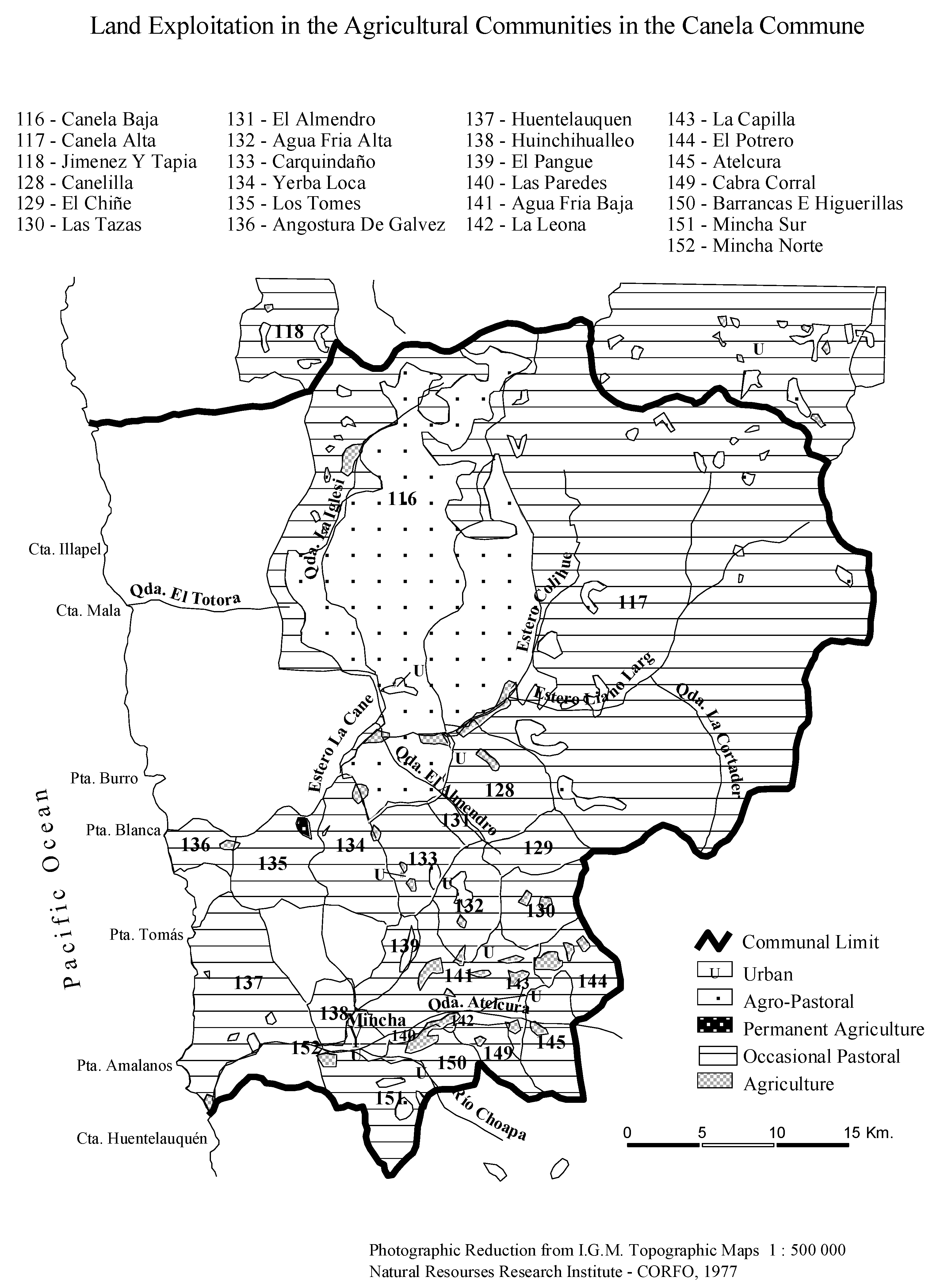
Figure 3.
Google map (B) of the Huentelauquén area, showing the subdivision of the Fundo Agua Dulce in the northern part of the map, bordering the sea. The map (A) shows the subdivision of the property in recreation plots for summer houses.
Figure 3.
Google map (B) of the Huentelauquén area, showing the subdivision of the Fundo Agua Dulce in the northern part of the map, bordering the sea. The map (A) shows the subdivision of the property in recreation plots for summer houses.
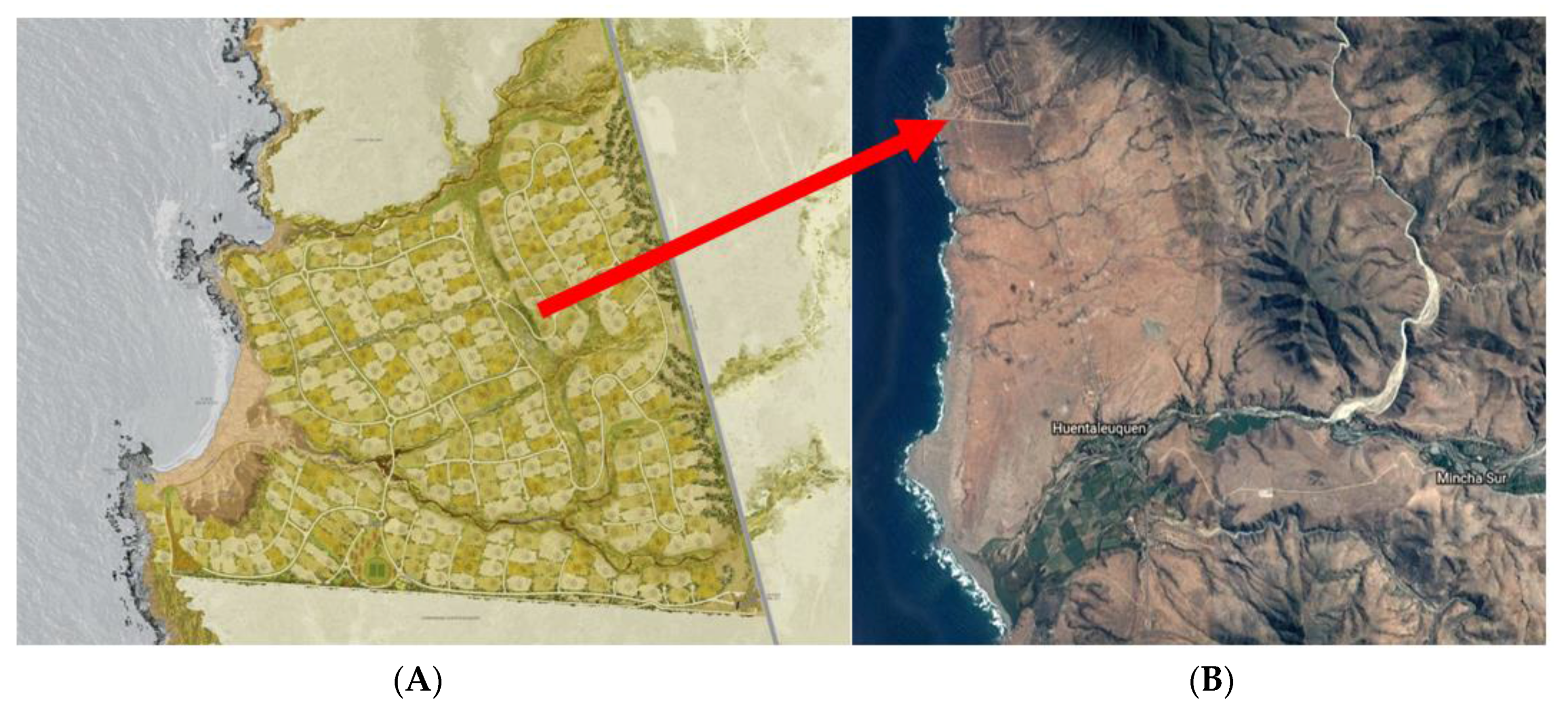

Figure 5.
Anti-miming protests Source: [65,66]. Picture (A) shows how commoners place burning tires to stop the traffic of the Highway to protest. The banner of the picture (B) says: “Let save the dunes and the wetlands of Huentelauquén, Mining companies out!”.
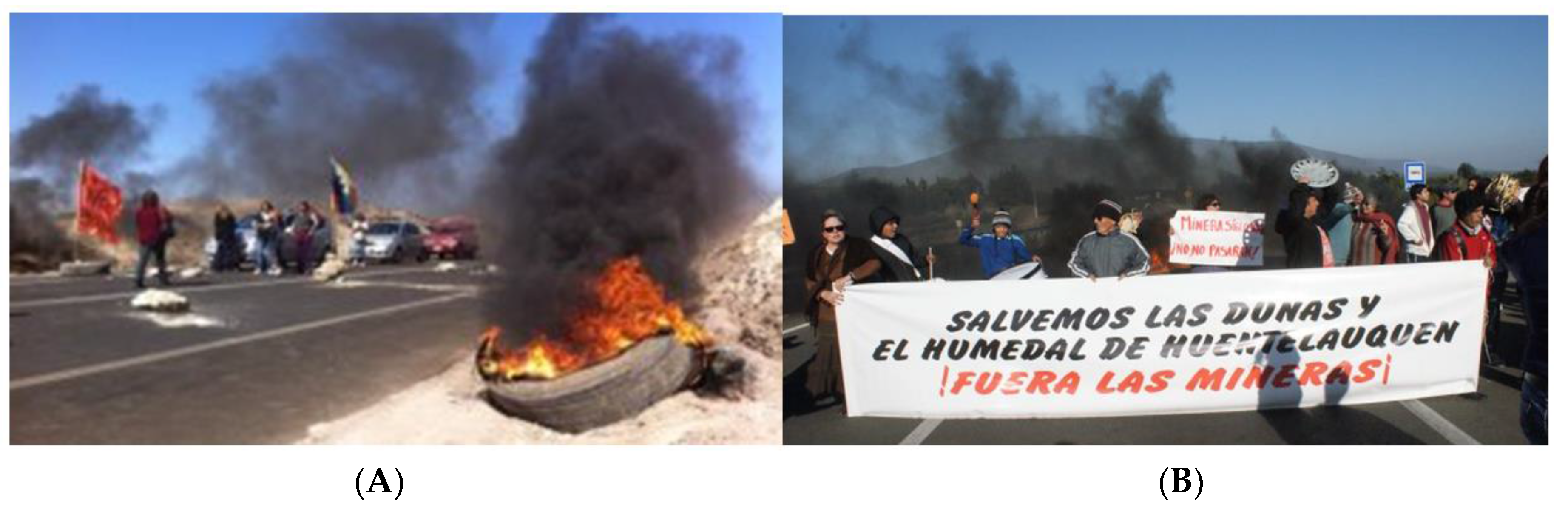
Figure 6.
Fundo Agua Dulce (picture taken by Gloria. L. Gallardo Fernández).
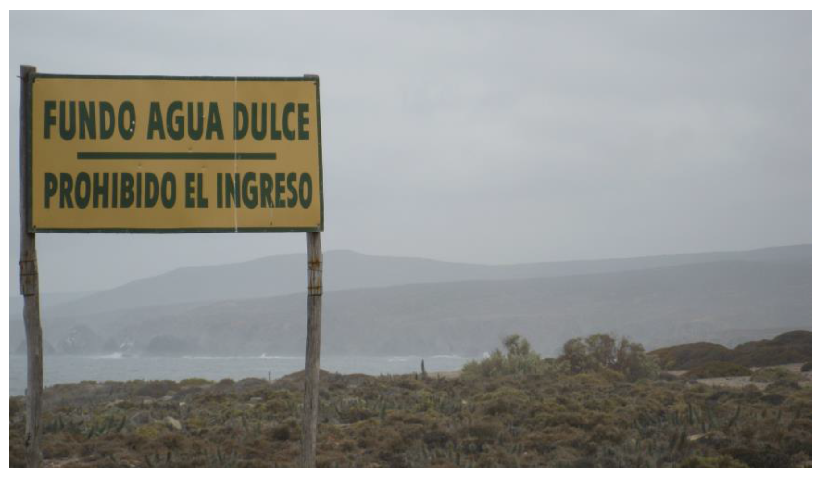

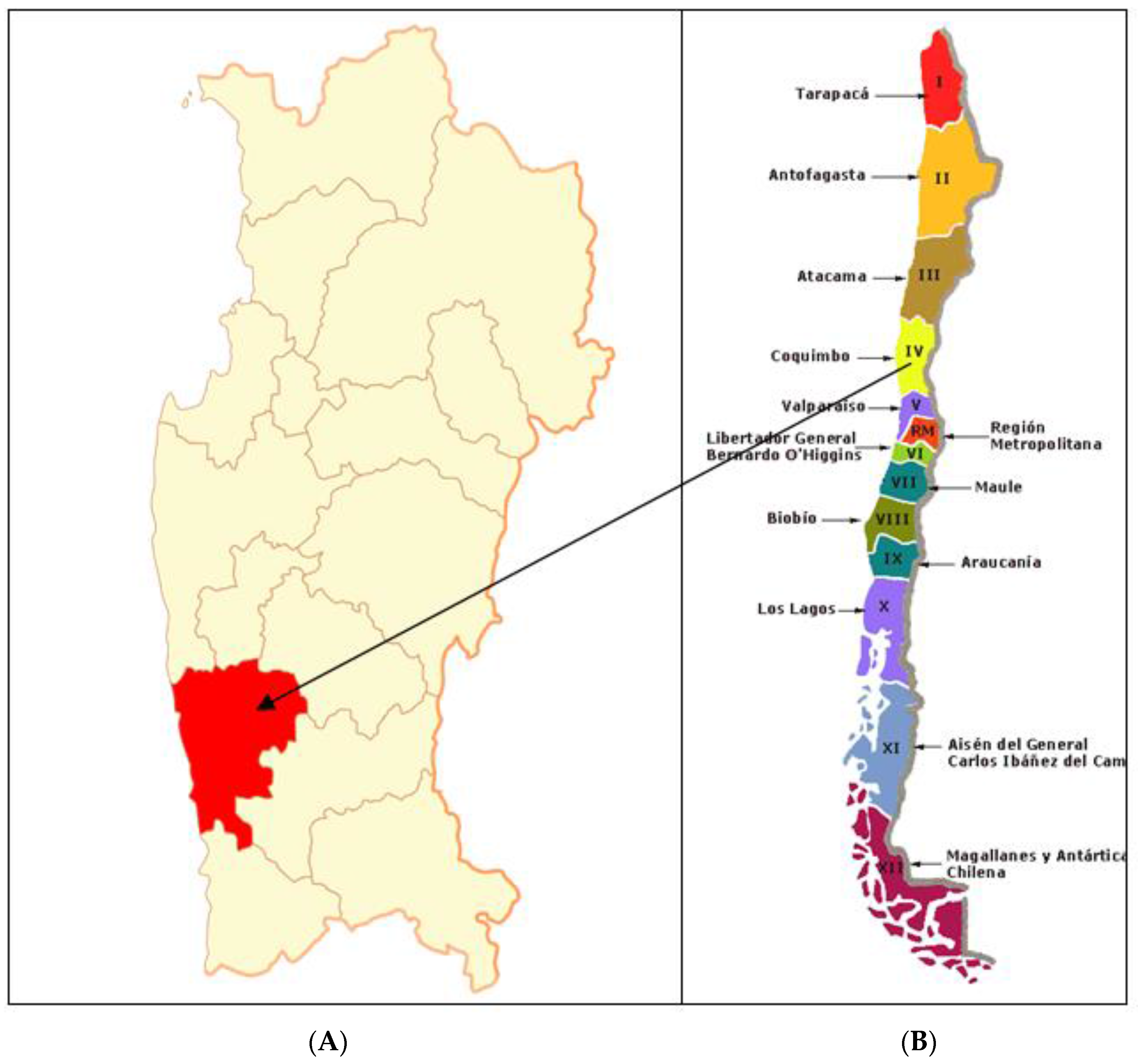
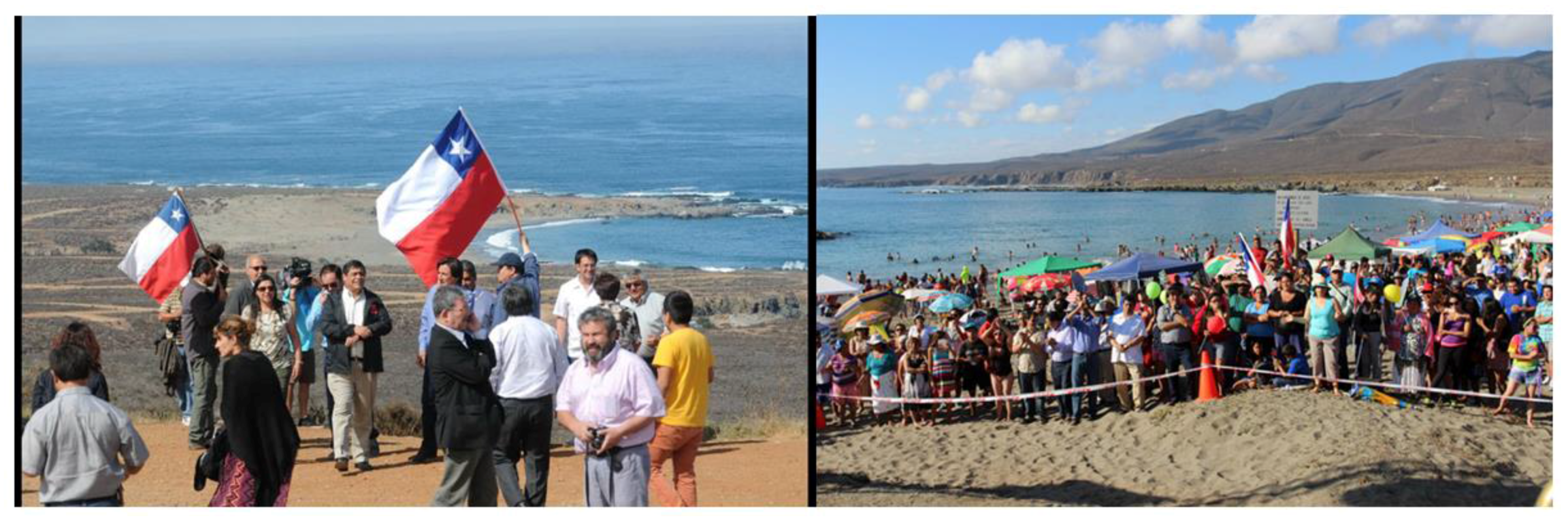
Table 1.
Land ownership in an agricultural community of IV Region of Coquimbo Source: [3].
Table 1.
Land ownership in an agricultural community of IV Region of Coquimbo Source: [3].
| Type of Exploitation | Duration | Type of Tenure |
|---|---|---|
| Individual use: | ||
| Agricultural exploitation | Permanent Limited | A. Land granted by the community (irrigated hijuelas for horticulture) |
| B. Land granted by the community (lluvias for rain-fed agriculture) | ||
| Communal: | ||
| Pastoral exploitation | Permanent Limited | A. Undivided property of all communeros (campos communes for pasture) |
| B. Undivided property belonging to several communities (encierras communes for pasture) |
Table 2.
Sampling: actors interviewed and topics covered.
| Interviewees | Topics Covered |
|---|---|
| Key Informants and Members of the HAC | |
| L. R. Ibacache: male commoner, farmer, goat herder and algae collector. Open and semi-structured interviews: 2013, 2014 and 2017. |
|
| M. Trigo (a): female commoner, ex-secretary of the board of the agricultural community. Open and semi-structured interviews: 2013, 2014 |
|
| E. Ollarzú: male commoner and primary school teacher. Semi-structured interview: 2014N. Trigo (b): male commoner, former Mayor of the Canela Commune. Semi-structured interview: 2014. |
|
| Key Informants Related to the Municipality of Commune | |
| C. Narvaez: architect, head of Public Works in the Canela Municipality. Open and semi-structured interviews: 2013, 2014 |
|
| E. Cortés: Lawyer, former legal advisor to the Municipality. Open and semi-structured interview: 2014 |
|
| Other Consulted Stakeholders | |
| E. Cortes: Private lawyer, advisor in matters of land compensations (same as above). Open interview: 2017 |
|
| J. C. Moller: Sale manager of Agua 2013 (personal communication) |
|
| C. Gallardo; potential buyer 2014 (personal communication) |
|
| F. Irarazabal, summer house resident of land alienated 1990. Open interview via skype: 2017 |
|
| A. Spaolonzi, commercial engineer Agua Dulce Project. Personal communication, 2018 (see also www.aguadulce.cl, accessed 2017-09-10) |
|
Table 3.
Historic time-line of the different sectoral developments affecting the Huentelauquén Agricultural Community.
Table 3.
Historic time-line of the different sectoral developments affecting the Huentelauquén Agricultural Community.
| Sectoral Developments Affecting the Huentelauquén Agricultural Community | ||||
|---|---|---|---|---|
| Year | Events Related to Land Issues | Number of Alienated ha | Number of Remaining ha | Destiny of Sold Land/Purpose |
| 1995 | 1st alienation of common lands (Agua Dulce) for real-estate development t | 352 | 7074 | Private enclosure condominium with 337 plots. |
| 1999 | 2nd alienation of common lands for subdivision as private rural recreational land for the HAC’s commoners. | 174 | 6900 | 348 private rural recreational land. In total, 193 (or 56%) plots were sold January 2013. ca. 150 individual houses of diverse standard have been constructed; some of them on irregular subdivided plots. |
| Since the 1980 approx. | Acquisition of commoner’s rights by new urban outsiders | Uncertain no. of ha, but 43 land rights | These do not alter the total no. of ha. | |
| 2010 | Mining concession allocated to Pichara | 12 ha | 6888 ha. (The land still belongs to the community | In operation through an agreement with HAC |
| 2012 | Mining concession allocated to Siglo XXI in the coastal dunes | 621 ha | 6267 ha. The land belongs still to the community. | The concession is still legal but the mining operations has been stopped, pending further legal clarification. As strategy; the HAC have also requested ten mining concessions in the same dunes around Siglo XXI’s concession. |
| 2013–2014 | New ongoing subdivisions of the common lands: (1) In the coastal part of the community (2)On both sides of the Pan American highway. | 34 ha as use rights to the HAC’s commoners as individual goces singulars 343 ha (1 ha. to each commoner as individual goce singulares | 6233 ha 5890 | Individual land plots of 1000 m2 to the HAC’s 343 commoners as strategy to hinder potential mining concession and operationsProbably to establish restaurants, food services, etc. to attract trade from passing traffic |
| 2010–2011 | Frustrated wind energy park project. | Uncertain no. of ha. but 40 wind turbines were planned | ||
© 2018 by the authors. Licensee MDPI, Basel, Switzerland. This article is an open access article distributed under the terms and conditions of the Creative Commons Attribution (CC BY) license (http://creativecommons.org/licenses/by/4.0/).
Share and Cite
MDPI and ACS Style
Gallardo Fernández, G.L.; Saunders, F. Commoditization of Rural Lands in the Semi-Arid Region of Chile—The Case of the Huentelauquén Agricultural Community. Agriculture 2018, 8, 26. https://doi.org/10.3390/agriculture8020026
AMA Style
Gallardo Fernández GL, Saunders F. Commoditization of Rural Lands in the Semi-Arid Region of Chile—The Case of the Huentelauquén Agricultural Community. Agriculture. 2018; 8(2):26. https://doi.org/10.3390/agriculture8020026
Chicago/Turabian StyleGallardo Fernández, Gloria L., and Fred Saunders. 2018. "Commoditization of Rural Lands in the Semi-Arid Region of Chile—The Case of the Huentelauquén Agricultural Community" Agriculture 8, no. 2: 26. https://doi.org/10.3390/agriculture8020026
Note that from the first issue of 2016, this journal uses article numbers instead of page numbers. See further details here.