Simulating Future Exposure to Coastal Urban Flooding Using a Neural Network–Markov Model
Abstract
1. Introduction
2. Materials and Methods
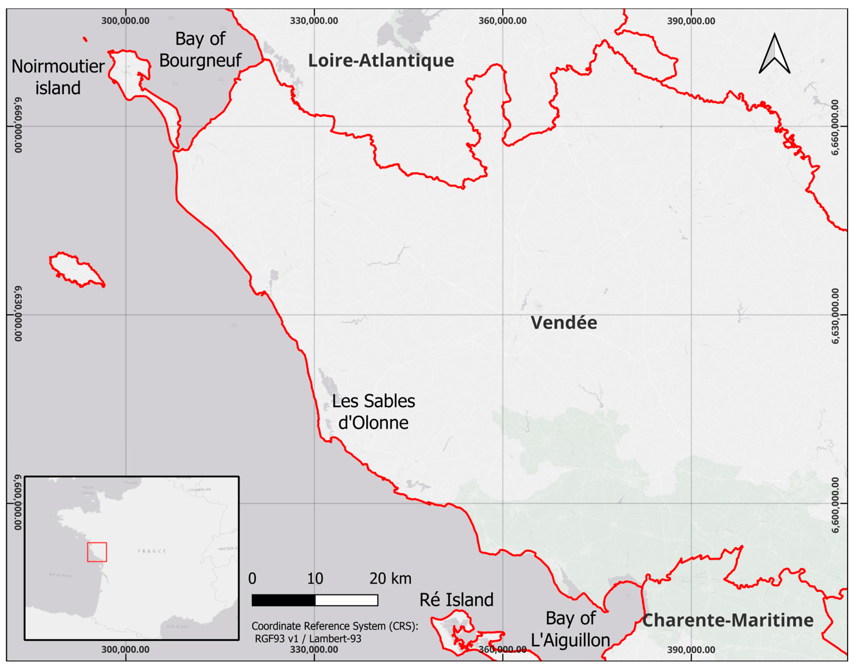
2.1. Study Area
2.2. Data Used
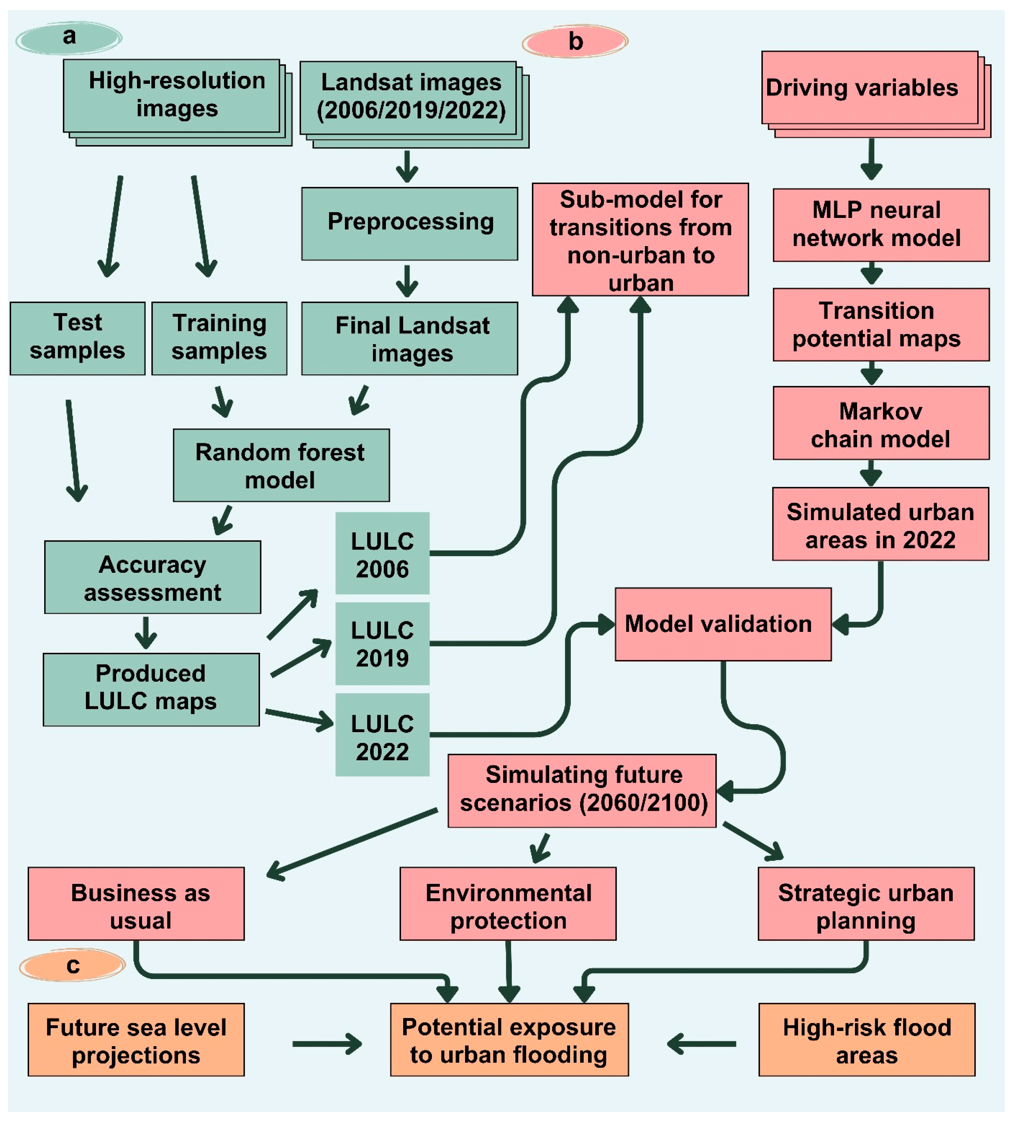
2.3. Method
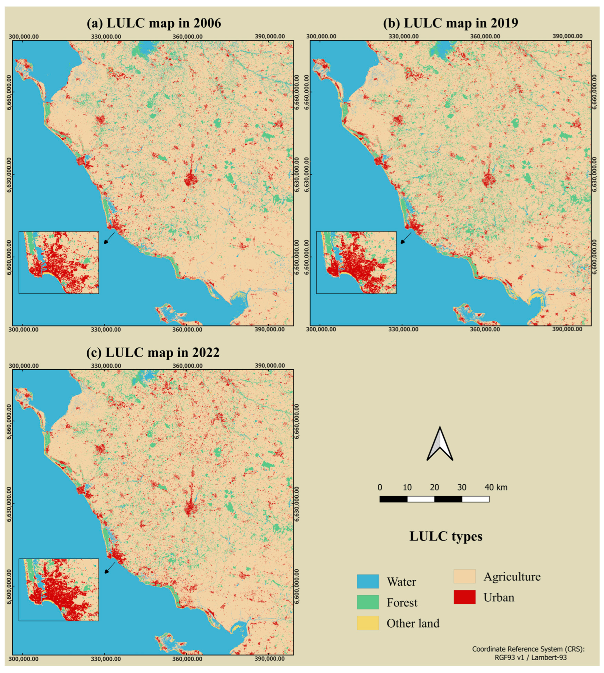
2.3.1. LULC Classification
2.3.2. Urban Growth Modeling
Selection of Driving Variables
Transition Potential Modeling
Scenario Setting for Future Urban Growth Simulation
Model Validation
2.3.3. Assessment of Potential Exposure to Urban Flooding
3. Results and Discussion
3.1. Accuracy of LULC Map Classification
3.2. Model Validation and Prediction of Future Urban Growth
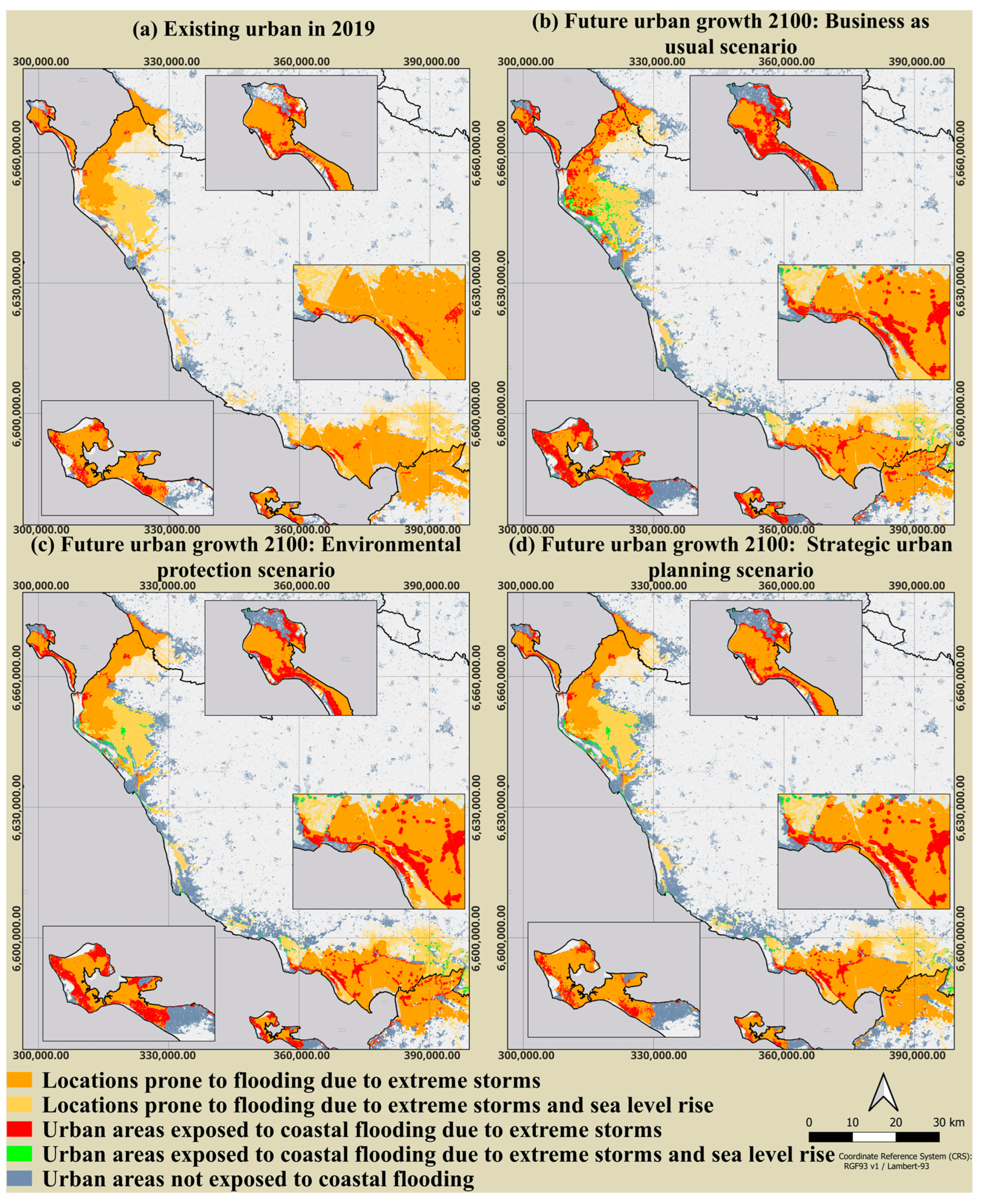
3.3. Evaluation of Urban Exposure to Flooding
4. Conclusions
Author Contributions
Funding
Institutional Review Board Statement
Informed Consent Statement
Data Availability Statement
Acknowledgments
Conflicts of Interest
References
- Carter, J.G. Urban Climate Change Adaptation: Exploring the Implications of Future Land Cover Scenarios. Cities 2018, 77, 73–80. [Google Scholar] [CrossRef]
- Hinkel, J.; Lincke, D.; Vafeidis, A.T.; Perrette, M.; Nicholls, R.J.; Tol, R.S.J.; Marzeion, B.; Fettweis, X.; Ionescu, C.; Levermann, A. Coastal Flood Damage and Adaptation Costs under 21st Century Sea-Level Rise. Proc. Natl. Acad. Sci. USA 2014, 111, 3292–3297. [Google Scholar] [CrossRef]
- Seto, K.C.; Güneralp, B.; Hutyra, L.R. Global Forecasts of Urban Expansion to 2030 and Direct Impacts on Biodiversity and Carbon Pools. Proc. Natl. Acad. Sci. USA 2012, 109, 16083–16088. [Google Scholar] [CrossRef]
- Rifat, S.A.A.; Liu, W. Predicting Future Urban Growth Scenarios and Potential Urban Flood Exposure Using Artificial Neural Network-Markov Chain Model in Miami Metropolitan Area. Land Use Policy 2022, 114, 105994. [Google Scholar] [CrossRef]
- Neumann, B.; Vafeidis, A.T.; Zimmermann, J.; Nicholls, R.J. Future Coastal Population Growth and Exposure to Sea-Level Rise and Coastal Flooding—A Global Assessment. PLoS ONE 2015, 10, e0118571. [Google Scholar] [CrossRef]
- Brown, S.; Nicholls, R.J.; Woodroffe, C.D.; Hanson, S.; Hinkel, J.; Kebede, A.S.; Neumann, B.; Vafeidis, A.T. Sea-Level Rise Impacts and Responses: A Global Perspective. Coast. Res. Libr. 2013, 1000, 117–149. [Google Scholar] [CrossRef]
- Kron, W. Coasts: The High-Risk Areas of the World. Nat. Hazards 2013, 66, 1363–1382. [Google Scholar] [CrossRef]
- Tzepkenlis, A.; Grammalidis, N.; Kontopoulos, C.; Charalampopoulou, V.; Kitsiou, D.; Pataki, Z.; Patera, A.; Nitis, T. An Integrated Monitoring System for Coastal and Riparian Areas Based on Remote Sensing and Machine Learning. J. Mar. Sci. Eng. 2022, 10, 1322. [Google Scholar] [CrossRef]
- Breilh, J.F.; Bertin, X.; Chaumillon, É.; Giloy, N.; Sauzeau, T. How Frequent Is Storm-Induced Flooding in the Central Part of the Bay of Biscay? Glob. Planet. Change 2014, 122, 161–175. [Google Scholar] [CrossRef]
- Nicholls, R.J. Planning for the Impacts of Sea Level Rise. Oceanography 2011, 24, 144–157. [Google Scholar] [CrossRef]
- Nicholls, R.J. Coastal Flooding and Wetland Loss in the 21st Century: Changes under the SRES Climate and Socio-Economic Scenarios. Glob. Environ. Change 2004, 14, 69–86. [Google Scholar] [CrossRef]
- Ranasinghe, R. Assessing Climate Change Impacts on Open Sandy Coasts: A Review. Earth Sci. Rev. 2016, 160, 320–332. [Google Scholar] [CrossRef]
- Masson-Delmotte, V.; Zhai, P.; Pirani, S.; Connors, C.; Péan, S.; Berger, N.; Caud, Y.; Chen, L.; Goldfarb, M.; Scheel Monteiro, P.M. IPCC, 2021: Summary for Policymakers. In Climate Change 2021—The Physical Science Basis: Working Group I Contribution to the Sixth Assessment Report of the Intergovernmental Panel on Climate Change; Cambridge University Press: Cambridge, UK, 2021. [Google Scholar] [CrossRef]
- Chen, Y. An Extended Patch-Based Cellular Automaton to Simulate Horizontal and Vertical Urban Growth under the Shared Socioeconomic Pathways. Comput. Environ. Urban Syst. 2022, 91, 101727. [Google Scholar] [CrossRef]
- Clarke, K.C.; Hoppen, S.; Gaydos, L. A Self-Modifying Cellular Automaton Model of Historical Urbanization in the San Francisco Bay Area. Environ. Plan. B Plan. Des. 1997, 24, 247–261. [Google Scholar] [CrossRef]
- Vaz, E.d.N.; Nijkamp, P.; Painho, M.; Caetano, M. A Multi-Scenario Forecast of Urban Change: A Study on Urban Growth in the Algarve. Landsc. Urban Plan. 2012, 104, 201–211. [Google Scholar] [CrossRef]
- Kamusoko, C.; Gamba, J. Simulating Urban Growth Using a Random Forest-Cellular Automata (RF-CA) Model. ISPRS Int. J. Geo-Inf. 2015, 4, 447–470. [Google Scholar] [CrossRef]
- Chaudhuri, G.; Clarke, K.C. Modeling an Indian Megalopolis– A Case Study on Adapting SLEUTH Urban Growth Model. Comput. Environ. Urban Syst. 2019, 77, 101358. [Google Scholar] [CrossRef]
- Silva, E.A.; Clarke, K.C. Calibration of the SLEUTH Urban Growth Model for Lisbon and Porto, Portugal. Comput. Environ. Urban Syst. 2002, 26, 525–552. [Google Scholar] [CrossRef]
- Shafizadeh-Moghadam, H. Improving Spatial Accuracy of Urban Growth Simulation Models Using Ensemble Forecasting Approaches. Comput. Environ. Urban Syst. 2019, 76, 91–100. [Google Scholar] [CrossRef]
- Yang, X.; Chen, R.; Zheng, X.Q. Simulating Land Use Change by Integrating ANN-CA Model and Landscape Pattern Indices. Geomat. Nat. Hazards Risk 2015, 7, 918–932. [Google Scholar] [CrossRef]
- Guan, D.J.; Li, H.F.; Inohae, T.; Su, W.; Nagaie, T.; Hokao, K. Modeling Urban Land Use Change by the Integration of Cellular Automaton and Markov Model. Ecol. Modell. 2011, 222, 3761–3772. [Google Scholar] [CrossRef]
- Shafizadeh Moghadam, H.; Helbich, M. Spatiotemporal Urbanization Processes in the Megacity of Mumbai, India: A Markov Chains-Cellular Automata Urban Growth Model. Appl. Geogr. 2013, 40, 140–149. [Google Scholar] [CrossRef]
- Tang, J.; Wang, L.; Yao, Z. Spatio-Temporal Urban Landscape Change Analysis Using the Markov Chain Model and a Modified Genetic Algorithm. Int. J. Remote Sens. 2007, 28, 3255–3271. [Google Scholar] [CrossRef]
- Thapa, R.B.; Murayama, Y. Scenario Based Urban Growth Allocation in Kathmandu Valley, Nepal. Landsc. Urban Plan. 2012, 105, 140–148. [Google Scholar] [CrossRef]
- Iizuka, K.; Johnson, B.A.; Onishi, A.; Magcale-Macandog, D.B.; Endo, I.; Bragais, M. Modeling Future Urban Sprawl and Landscape Change in the Laguna de Bay Area, Philippines. Land 2017, 6, 26. [Google Scholar] [CrossRef]
- Simwanda, M.; Murayama, Y.; Phiri, D.; Nyirenda, V.R.; Ranagalage, M. Simulating Scenarios of Future Intra-Urban Land-Use Expansion Based on the Neural Network–Markov Model: A Case Study of Lusaka, Zambia. Remote Sens. 2021, 13, 942. [Google Scholar] [CrossRef]
- Lu, Y.; Wang, X.; Xie, Y.; Li, K.; Xu, Y. Integrating Future Land Use Scenarios to Evaluate the Spatio-Temporal Dynamics of Landscape Ecological Security. Sustainability 2016, 8, 1242. [Google Scholar] [CrossRef]
- Shi, Y.; Wu, J.; Shi, S. Study of the Simulated Expansion Boundary of Construction Land in Shanghai Based on a SLEUTH Model. Sustainability 2017, 9, 876. [Google Scholar] [CrossRef]
- Ranagalage, M.; Wang, R.; Gunarathna, M.H.J.P.; Dissanayake, D.M.S.L.B.; Murayama, Y.; Simwanda, M. Spatial Forecasting of the Landscape in Rapidly Urbanizing Hill Stations of South Asia: A Case Study of Nuwara Eliya, Sri Lanka (1996–2037). Remote Sens. 2019, 11, 1743. [Google Scholar] [CrossRef]
- Nath, B.; Wang, Z.; Ge, Y.; Islam, K.; Singh, R.P.; Niu, Z. Land Use and Land Cover Change Modeling and Future Potential Landscape Risk Assessment Using Markov-CA Model and Analytical Hierarchy Process. ISPRS Int. J. Geo-Inf. 2020, 9, 134. [Google Scholar] [CrossRef]
- Hinestroza-Mena, K.M.; Toro, V.G.; Londoño-Colorado, G.S.; Chávez, V.; García-Blanco, J.K.; Silva, R. Fine Spatial Scale, Frequent Morphological Monitoring of Urbanised Beaches to Improve Coastal Management. J. Mar. Sci. Eng. 2021, 9, 550. [Google Scholar] [CrossRef]
- Tsagkis, P.; Bakogiannis, E.; Nikitas, A. Analysing Urban Growth Using Machine Learning and Open Data: An Artificial Neural Network Modelled Case Study of Five Greek Cities. Sustain. Cities Soc. 2023, 89, 104337. [Google Scholar] [CrossRef]
- Abouhalima, M.; das Neves, L.; Taveira-Pinto, F.; Rosa-Santos, P. Machine Learning in Coastal Engineering: Applications, Challenges, and Perspectives. J. Mar. Sci. Eng. 2024, 12, 638. [Google Scholar] [CrossRef]
- Huong, H.T.L.; Pathirana, A. Urbanization and Climate Change Impacts on Future Urban Flooding in Can Tho City, Vietnam. Hydrol. Earth Syst. Sci. 2013, 17, 379–394. [Google Scholar] [CrossRef]
- Lu, Q.; Joyce, J.; Imen, S.; Chang, N. Bin Linking Socioeconomic Development, Sea Level Rise, and Climate Change Impacts on Urban Growth in New York City with a Fuzzy Cellular Automata-Based Markov Chain Model. Environ. Plan. B Urban Anal. City Sci. 2019, 46, 551–572. [Google Scholar] [CrossRef]
- Song, J.; Fu, X.; Gu, Y.; Deng, Y.; Peng, Z.R. An Examination of Land Use Impacts of Flooding Induced by Sea Level Rise. Nat. Hazards Earth Syst. Sci. 2017, 17, 315–334. [Google Scholar] [CrossRef]
- Audère, M.; Robin, M. Assessment of the Vulnerability of Sandy Coasts to Erosion (Short and Medium Term) for Coastal Risk Mapping (Vendée, W France). Ocean Coast. Manag. 2021, 201, 105452. [Google Scholar] [CrossRef]
- Bertin, X.; Li, K.; Roland, A.; Zhang, Y.J.; Breilh, J.F.; Chaumillon, E. A Modeling-Based Analysis of the Flooding Associated with Xynthia, Central Bay of Biscay. Coast. Eng. 2014, 94, 80–89. [Google Scholar] [CrossRef]
- Bertin, X.; Bruneau, N.; Breilh, J.F.; Fortunato, A.B.; Karpytchev, M. Importance of Wave Age and Resonance in Storm Surges: The Case Xynthia, Bay of Biscay. Ocean. Model. 2012, 42, 16–30. [Google Scholar] [CrossRef]
- Kolen, B.; Slomp, R.; Jonkman, S.N. The Impacts of Storm Xynthia February 27–28, 2010 in France: Lessons for Flood Risk Management. J. Flood Risk Manag. 2013, 6, 261–278. [Google Scholar] [CrossRef]
- Kron, W.; Löw, P.; Kundzewicz, Z.W. Changes in Risk of Extreme Weather Events in Europe. Environ. Sci. Policy 2019, 100, 74–83. [Google Scholar] [CrossRef]
- Foga, S.; Scaramuzza, P.L.; Guo, S.; Zhu, Z.; Dilley, R.D.; Beckmann, T.; Schmidt, G.L.; Dwyer, J.L.; Joseph Hughes, M.; Laue, B. Cloud Detection Algorithm Comparison and Validation for Operational Landsat Data Products. Remote Sens. Environ. 2017, 194, 379–390. [Google Scholar] [CrossRef]
- Noi Phan, T.; Kuch, V.; Lehnert, L.W. Land Cover Classification Using Google Earth Engine and Random Forest Classifier-the Role of Image Composition. Remote Sens. 2020, 12, 2411. [Google Scholar] [CrossRef]
- Jin, Y.; Liu, X.; Chen, Y.; Liang, X. Land-Cover Mapping Using Random Forest Classification and Incorporating NDVI Time-Series and Texture: A Case Study of Central Shandong. Int. J. Remote Sens. 2018, 39, 8703–8723. [Google Scholar] [CrossRef]
- Li, X.; Chen, W.; Cheng, X.; Wang, L. A Comparison of Machine Learning Algorithms for Mapping of Complex Surface-Mined and Agricultural Landscapes Using ZiYuan-3 Stereo Satellite Imagery. Remote Sens. 2016, 8, 514. [Google Scholar] [CrossRef]
- Millard, K.; Richardson, M. On the Importance of Training Data Sample Selection in Random Forest Image Classification: A Case Study in Peatland Ecosystem Mapping. Remote Sens. 2015, 7, 8489–8515. [Google Scholar] [CrossRef]
- Nasiri, V.; Deljouei, A.; Moradi, F.; Sadeghi, S.M.M.; Borz, S.A. Land Use and Land Cover Mapping Using Sentinel-2, Landsat-8 Satellite Images, and Google Earth Engine: A Comparison of Two Composition Methods. Remote Sens. 2022, 14, 1977. [Google Scholar] [CrossRef]
- Sheykhmousa, M.; Mahdianpari, M.; Ghanbari, H.; Mohammadimanesh, F.; Ghamisi, P.; Homayouni, S. Support Vector Machine Versus Random Forest for Remote Sensing Image Classification: A Meta-Analysis and Systematic Review. IEEE J. Sel. Top. Appl. Earth Obs. Remote Sens. 2020, 13, 6308–6325. [Google Scholar] [CrossRef]
- Maxwell, A.E.; Warner, T.A.; Fang, F. Implementation of Machine-Learning Classification in Remote Sensing: An Applied Review. Int. J. Remote Sens. 2018, 39, 2784–2817. [Google Scholar] [CrossRef]
- Pelletier, C.; Valero, S.; Inglada, J.; Champion, N.; Dedieu, G. Assessing the Robustness of Random Forests to Map Land Cover with High Resolution Satellite Image Time Series over Large Areas. Remote Sens. Environ. 2016, 187, 156–168. [Google Scholar] [CrossRef]
- Tamiminia, H.; Salehi, B.; Mahdianpari, M.; Quackenbush, L.; Adeli, S.; Brisco, B. Google Earth Engine for Geo-Big Data Applications: A Meta-Analysis and Systematic Review. ISPRS J. Photogramm. Remote Sens. 2020, 164, 152–170. [Google Scholar] [CrossRef]
- Breiman, L. Random Forests. Mach. Learn. 2001, 45, 5–32. [Google Scholar] [CrossRef]
- Breiman, L. Bagging Predictors. Mach. Learn. 1996, 24, 123–140. [Google Scholar] [CrossRef]
- Abdullah, S.A.; Nakagoshi, N. Changes in Landscape Spatial Pattern in the Highly Developing State of Selangor, Peninsular Malaysia. Landsc. Urban Plan. 2006, 77, 263–275. [Google Scholar] [CrossRef]
- Qiang, Y.; Lam, N.S.N. The Impact of Hurricane Katrina on Urban Growth in Louisiana: An Analysis Using Data Mining and Simulation Approaches. Int. J. Geogr. Inf. Sci. 2016, 30, 1832–1852. [Google Scholar] [CrossRef]
- Zhang, D.; Liu, X.; Wu, X.; Yao, Y.; Wu, X.; Chen, Y. Multiple Intra-Urban Land Use Simulations and Driving Factors Analysis: A Case Study in Huicheng, China. GIsci Remote Sens. 2019, 56, 282–308. [Google Scholar] [CrossRef]
- Abuelaish, B.; Olmedo, M.T.C. Scenario of Land Use and Land Cover Change in the Gaza Strip Using Remote Sensing and GIS Models. Arab. J. Geosci. 2016, 9, 274. [Google Scholar] [CrossRef]
- Nadoushan, M.A.; Soffianian, A.; Alebrahim, A. Predicting Urban Expansion in Arak Metropolitan Area Using Two Land Change Models. World Appl. Sci. J. 2012, 18, 1124–1132. [Google Scholar] [CrossRef]
- Pontius, R.G. Quantification Error versus Location Error in Comparison of Categorical Maps. Photogramm. Eng. Remote Sens. 2000, 66, 1011–1016. [Google Scholar]
- Islam, K.; Rahman, M.F.; Jashimuddin, M. Modeling Land Use Change Using Cellular Automata and Artificial Neural Network: The Case of Chunati Wildlife Sanctuary, Bangladesh. Ecol. Indic. 2018, 88, 439–453. [Google Scholar] [CrossRef]
- Pontius, R.G.; Millones, M. Death to Kappa: Birth of Quantity Disagreement and Allocation Disagreement for Accuracy Assessment. Int. J. Remote Sens. 2011, 32, 4407–4429. [Google Scholar] [CrossRef]
- Pontius, R.G.; Parmentier, B. Recommendations for Using the Relative Operating Characteristic (ROC). Landsc. Ecol. 2014, 29, 367–382. [Google Scholar] [CrossRef]
- Pontius, R.G.; Schneider, L.C. Land-Cover Change Model Validation by an ROC Method for the Ipswich Watershed, Massachusetts, USA. Agric. Ecosyst. Environ. 2001, 85, 239–248. [Google Scholar] [CrossRef]
- Masson-Delmotte, V.; Zhai, P.; Chen, Y.; Goldfarb, L.; Gomis, M.I.; Matthews, J.B.R.; Berger, S.; Huang, M.; Yelekçi, O.; Yu, R.; et al. Working Group I Contribution to the Sixth Assessment Report of the Intergovernmental Panel on Climate Change; Cambridge University Press: Cambridge, UK, 2021. [Google Scholar] [CrossRef]
- Osgouei, P.E.; Kaya, S.; Sertel, E.; Alganci, U. Separating Built-up Areas from Bare Land in Mediterranean Cities Using Sentinel-2A Imagery. Remote Sens. 2019, 11, 345. [Google Scholar] [CrossRef]
- Zhao, Y.; Zhu, Z. ASI: An Artificial Surface Index for Landsat 8 Imagery. Int. J. Appl. Earth Obs. Geoinf. 2022, 107, 102703. [Google Scholar] [CrossRef]


| Data | Format | Data Source | Year | Resolution |
|---|---|---|---|---|
| DEM | Raster | BD ALTI® https://geoservices.ign.fr/bdalti, accessed on 23 February 2023 | 2022 | 25 m |
| Road network | Vector | ROUTE 500® https://geoservices.ign.fr/route500, accessed on 3 March 2023 | 2021 | N/A |
| Coastal boundary | Vector | LIMITE TERRE-MER https://geoservices.ign.fr/limite-terre-mer, accessed on 3 March 2023 | 2021 | N/A |
| Protected zones | Vector | INPN—Données du programme ‘Espaces Protégés’ https://www.data.gouv.fr/fr/datasets/inpn-donnees-du-programme-espaces-proteges/#/resources, accessed on 10 March 2023 | 2022 | N/A |
| Natural Risk Prevention Plan | Vector | Plans de Préventions des Risques naturels https://www.georisques.gouv.fr/plans-de-prevention-des-risques-naturels, accessed on 10 March 2023 | 2023 | N/A |
| High-risk flood areas | Vector | Territoires à Risques important d’Inondation (TRI)—version 2 https://www.georisques.gouv.fr/donnees/bases-de-donnees/zonages-inondation-rapportage-2020, accessed on 10 March 2023 | 2020 | N/A |
| Future sea level projection | CSV formatted | This data produced by the IPCC authors and supplied for archiving at the Centre for Environmental Data Analysis (CEDA) https://catalogue.ceda.ac.uk/uuid/98af2184e13e4b91893ab72f301790db, accessed on 10 March 2023 | 2060/ 2100 | N/A |
| Modeling Variables | Urban Growth Scenarios | ||
|---|---|---|---|
| Business as Usual | Environmental Protection | Strategic Urban Planning | |
| Drivers of urban growth | Digital elevation model | Digital elevation model | Digital elevation model |
| Slope | Slope | Slope | |
| Distance to major roads | Distance to major roads | Distance to major roads | |
| Distance to coast | Distance to coast | Distance to coast | |
| Distance to existing urban area | Distance to existing urban area | Distance to existing urban area | |
| Evidence likelihood | Evidence likelihood | Evidence likelihood | |
| Constraints | Existing urban areas | Existing urban areas | Existing urban areas |
| Water bodies | Water bodies | Water bodies | |
| Protected natural areas | Protected natural areas | ||
| Restricted urbanization zones | |||
| Accuracy Measure | Definition | Range | Expected Minimum Threshold |
|---|---|---|---|
| Kno | Kno measures the overall accuracy of the simulated map by comparing the proportion of correctly predicted pixels with the anticipated proportion [59,60,61]. | −1 to 1 | >0.8 |
| Kappa Kstandard | Kstandard assesses the map’s ability to achieve perfect classification [59,60,61]. | −1 to 1 | >0.8 |
| Klocation | Klocation assesses the simulation’s accuracy based solely on location [59,60,61]. | −1 to 1 | >0.8 |
| Quantity disagreement | Quantity disagreement represents the degree to which the predicted map fails to reflect the precise quantity of each LULC class, when compared to the reference map, not taking into account location [62]. | 0 to 100% | Overall disagreement (Quantity disagreement + Allocation disagreement) < 20% |
| Allocation disagreement | Allocation disagreement represents the degree to which the predicted map fails to reflect the precise position of each LULC class [62]. | 0 to 100% | Overall disagreement (Quantity disagreement + Allocation disagreement) < 20% |
| Overall agreement | Overall agreement is determined by omitting both quantity and allocation disagreement [62]. | 0 to 100% | >80% |
| Area under the curve (AUC) | Area under the curve is a quantitative measure derived from the Relative Operating Characteristic curve that compares the probability of a class occurring to its actual location [63,64]. | 0 to 1 | >0.5 |
| Accuracy | LULC 2006 | LULC 2019 | LULC 2022 |
|---|---|---|---|
| Overall accuracy (%) | 93.26 | 95.11 | 94.04 |
| Kappa coefficient (K) | 0.91 | 0.93 | 0.92 |
| Year | Classified Data | Reference Data | ||||
|---|---|---|---|---|---|---|
| Water | Forest | Other Land | Agriculture | Urban | ||
| 2022 | Water | 212 | 6 | 6 | 4 | 0 |
| Forest | 0 | 204 | 0 | 5 | 0 | |
| Other land | 3 | 0 | 207 | 2 | 8 | |
| Agriculture | 1 | 1 | 0 | 400 | 13 | |
| Urban | 0 | 0 | 6 | 22 | 193 | |
| 2019 | Water | 229 | 4 | 2 | 0 | 0 |
| Forest | 3 | 224 | 0 | 3 | 0 | |
| Other land | 1 | 0 | 202 | 1 | 3 | |
| Agriculture | 1 | 3 | 0 | 391 | 26 | |
| Urban | 0 | 1 | 4 | 11 | 180 | |
| 2006 | Water | 203 | 1 | 0 | 5 | 0 |
| Forest | 0 | 203 | 0 | 2 | 0 | |
| Other land | 0 | 0 | 217 | 3 | 7 | |
| Agriculture | 1 | 2 | 0 | 365 | 26 | |
| Urban | 0 | 0 | 9 | 29 | 190 | |
| Assessment Metrics | Urban Growth Scenarios | ||
|---|---|---|---|
| Business as Usual | Environmental Protection | Strategic Urban Planning | |
| Kno | 89.71 | 89.72 | 89.72 |
| Kappa Kstandard | 85.35 | 85.36 | 85.37 |
| Klocation | 88.63 | 88.64 | 88.65 |
| Quantity disagreement | 2.16 | 2.16 | 2.16 |
| Allocation disagreement | 6.41 | 6.41 | 6.40 |
| Overall agreement | 91.43 | 91.43 | 91.44 |
| AUC | 61.77 | 62.80 | 63.78 |
| Year | Total Urban Area (km2) | Urban Growth Scenario | Urban Areas Susceptible to Flooding Due to Extreme Storms (km2) | Urban Areas Susceptible to Flooding Due to Extreme Storms and Sea Level Rise (km2) |
|---|---|---|---|---|
| 2060 | 514.45 | Business as usual | 91.8592 | 94.4719 |
| Environmental protection | 78.139 | 79.6219 | ||
| Strategic urban planning | 58.3806 | 59.6068 | ||
| 2100 | 679.87 | Business as usual | 129.434 | 225.97 |
| Environmental protection | 98.8963 | 165.263 | ||
| Strategic urban planning | 68.4748 | 117.047 |
Disclaimer/Publisher’s Note: The statements, opinions and data contained in all publications are solely those of the individual author(s) and contributor(s) and not of MDPI and/or the editor(s). MDPI and/or the editor(s) disclaim responsibility for any injury to people or property resulting from any ideas, methods, instructions or products referred to in the content. |
© 2024 by the authors. Licensee MDPI, Basel, Switzerland. This article is an open access article distributed under the terms and conditions of the Creative Commons Attribution (CC BY) license (https://creativecommons.org/licenses/by/4.0/).
Share and Cite
Frifra, A.; Maanan, M.; Maanan, M.; Rhinane, H. Simulating Future Exposure to Coastal Urban Flooding Using a Neural Network–Markov Model. J. Mar. Sci. Eng. 2024, 12, 800. https://doi.org/10.3390/jmse12050800
Frifra A, Maanan M, Maanan M, Rhinane H. Simulating Future Exposure to Coastal Urban Flooding Using a Neural Network–Markov Model. Journal of Marine Science and Engineering. 2024; 12(5):800. https://doi.org/10.3390/jmse12050800
Chicago/Turabian StyleFrifra, Ayyoub, Mohamed Maanan, Mehdi Maanan, and Hassan Rhinane. 2024. "Simulating Future Exposure to Coastal Urban Flooding Using a Neural Network–Markov Model" Journal of Marine Science and Engineering 12, no. 5: 800. https://doi.org/10.3390/jmse12050800
APA StyleFrifra, A., Maanan, M., Maanan, M., & Rhinane, H. (2024). Simulating Future Exposure to Coastal Urban Flooding Using a Neural Network–Markov Model. Journal of Marine Science and Engineering, 12(5), 800. https://doi.org/10.3390/jmse12050800


