The Dynamics of People Movement Systems in Central Areas

Abstract
: Certain pedestrian facilities, by their nature and the spatial imperatives they impose, exert a powerful role in organizing and promoting the development of associated central places. The need for an expanded public space in the city has found expression in the new public spaces that have emerged in relation to this transport infrastructure within long developed urban environments. In contemporary, advanced urban society, such new spaces need to have polyvalent purposes and to respond to emergent demands. It is proposed that certain characteristics of these pedestrian systems support intensification and multiplication of activities over a particular spatial environment defined by activities. In the three cases—the Underground system of Montreal, Tokyo Station City and the Central Mid-levels Escalator area—common characteristics proposed as important to the achievement of the developmental goals include specific spatial relations, system open-endedness and structural complexity.1. The Dynamics of People Movement Systems in Central Areas
The literature on pedestrian facilities has been concerned with solving transportation problems, environmental improvement, and reducing the production of greenhouse gases. The facilities have largely been seen as means to resolve contemporary urban issues, but seldom as a powerful tool for physical and economic development at a local level. This paper is devoted to a consideration of such pedestrian facilities as a means to revitalize and rebuild urban space. The point of this paper is to examine such pedestrian facilities as infrastructure for development, using three case studies for evidence.
This paper is devoted to infrastructure for local movement, with emphasis on the outcomes in economic and cultural spheres within the same urban space. Measurable outcomes require a timeline where the impacts of investments can be detected directly. The cases presented here had their respective starts in the mid-1960s, in the case of the Montréal Underground, or, as late as 1994, in the case of the Mid-levels Escalator. Based on the empirical evidence, it is relational properties of both physical and social space, which are primarily responsible for the observed multiplier effects in social and economic domains. In addition, how the physical facilities are arranged within a larger open-ended urban environment helps explain how they achieve autonomy in the urban environment and promote ancillary growth.
The paper offers the evidence of local positive externalities as a result of these infrastructure investments. The tendency to attract and concentrate investment, to intensify and diversify activities, constitutes measurable outcomes. Qualities are essential aspects of this place creation, however [1]. Hallmarks include a thriving public life lived in a public space and supported by neighboring services, the emergence of poles of creativity and expression, an environment managed and cared for by local instances. The three cases are proposed to reveal actual instances of the hypothesized close relationship between open-ended infrastructure and the emergent uses and values that attach to the space around the infrastructure.
In the post-industrial city, we are concerned with creating new centralities. Cities are increasingly about communications and exchange, as production moves from durable goods to ideas [2]. Idea generation needs a public space, which includes Internet and other electronic media but also a physical space of exchange. Creation occurs within a context that provides a cultural crucible for meaningful exchange, but such a context also harbors the institutional underpinnings for the creative process. Such places have multiple meanings and where not all can be known in an instant. Instead of clarity, we have ambiguity [3]. Conventional thinking of the post-World War era favored clear definitions for urban space in terms of uses and the physical extent they were to occupy, supply-minded thinking designed to deal with shortfalls, conflicts and inequalities. The regeneration of urban space admitted complexity of uses and meanings, such that places acquired a certain functional and symbolic ambiguity. Initial intentions to support certain movements, following the conventional planning approach just evoked in the above sentences, certain activities quickly led to the incipience of other functions that attached themselves to the original ones. An example helps us see the process. Retailers have long recognized this relationship between flagship enterprise or magnets and dependent but related retailing outlets, and integrate such notions in the planning of shopping centers [4]. The incipient businesses cannot be entirely or clearly predicted, although a general development can be detected. An abundant literature in location theory [5], bid-rent theory [6] and economic geography [7] provides understanding of the basic relationships between urban functions and place. But as has been recognized in recent literature on the topic, our patterns of behavior are changing with the emergence of new trajectories and new centralities [8]. The qualities of place have acquired new importance in the outcomes in other domains, including the economic and the social. The images of business are augmented with cultural associations, and social venues also carry implicit meanings and channels. Cultural and place-based understandings tend to assert considerable importance in the project, with a diversity of major players, at least sufficient to create critical mass [9]. According to the theory being advanced here, creative energy seeks neutral territory where growth and change is possible. In contrast with modernist notions of specialization, separation and the dedication of transportation facilities, this urban phenomenon is about synergies, mix and place.
Research on central areas in the past several years has underscored values of place. The assets of globally important central areas include local expertise, world-class technology, specialized knowledge and network interaction [10]. In an increasingly globalized economy, we require place-centeredness to overcome the integration of networks and their “flattening” quality [11]. In more conventional language, the more extensive and integrated the network, the more we need centers to produce the ideas that then travel the networks. Certain places gain significance in the continuing expansion and complexification of networks. Face-to-face interactions remain very important [12], but have expanded from the need for direct communication for business transactions, which to some extent can take place virtually, to include social and cultural interactions, the foundation of the creative economy. In this newly expanded need for propinquity or being close to the “action”, local identities, cultures and images are important and have become part of the global.
Such globally significant places are not generic reproductions of a classical, functionalist model for organizing spaces and activities. Rather, they are branded with local realities that include historical rootedness, geographical meaning and cultural foundation. Geographers have highlighted the increasing importance of the local in globalization.
Increasingly it is the dynamics that invest a place that is central to the planning agenda, as functional changes modify the urban economic landscape. The dynamics are revealed in movement of people, activities that attach to the movement of people, real estate investment in relation to the movement systems. The traditional gravity models of urban economic geography [13] have been augmented with considerations of cognition and behavior [14] to explain a large part of visiting behavior in local environments. Travel distance remains a key factor in the physical extent of this activity space across the urban fabric, such that local environments will have a certain optimal dimension. Overall, non-motorized trips tend to increase where the origins and destinations have mixed land use and higher density and where the street network is highly connected, as in a grid layout [15–17]. While these theories and the empirical studies that support them provide convincing explanations of the distribution of local activities in urban space, they do not easily account for the intrinsic effects of activities in places–that they generate a certain level of internal activity due to proximity and exchange.
Such dynamic interactions are difficult to capture and measure, in part because activities may inflect on the arrangement and uses of space as much as the space may constrain and direct the deployment of activities in urban space. The approach here is to consider the impact of change over time in each of the studied systems, so as to be able to gauge the impact of specific changes in layout and local use on the distribution of activity.
2. Three Open-Ended Local Systems for Movement
The three cases are from very different regional and national contexts and were also produced in quite different institutional and physical contexts. The three cases illustrate an urban development process where infrastructure appeared to play a critical role in the value increase of properties adjacent to the infrastructure. They illustrate in particular how the system design is determinant of the economic structure of this dense concentration of investment. They also demonstrate the added value to individual parts of the circulation system of connectivity over the whole space.
2.1. The Montréal Underground
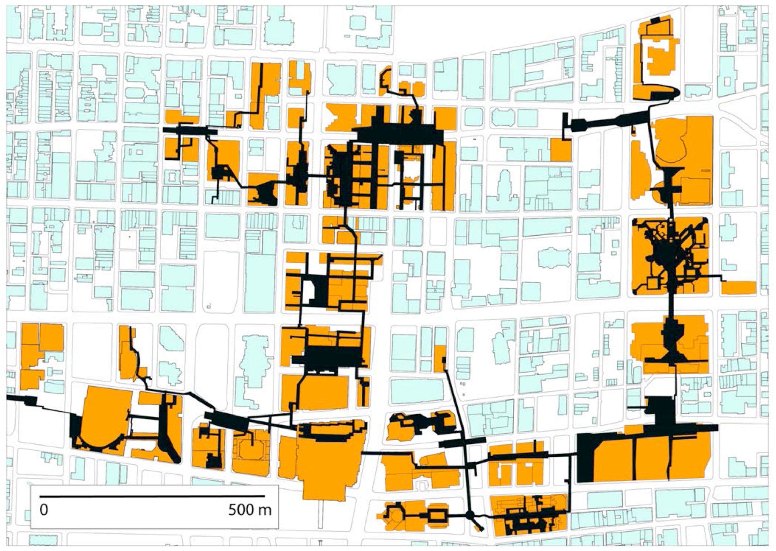
The Montréal Underground emerged from the city's development of a metro system, which set the conditions for the private development of the walking system, connected to the buildings that were built at the same time. While the city promoted the development of this Underground system, through the metro infrastructure and through certain regulatory measures, it allowed the system to develop on its own through private initiative, starting in 1966 and continuing into the 2010 decade [18]. Although the city has since exerted a stronger role in the management of this space, the system has evolved largely through private initiative. The Underground is a complete walking network mostly below street level in the center of Montréal, beneath the main business and shopping district. It connects six metro stations and numerous shopping centers and office buildings in a parallel system to that of the street.
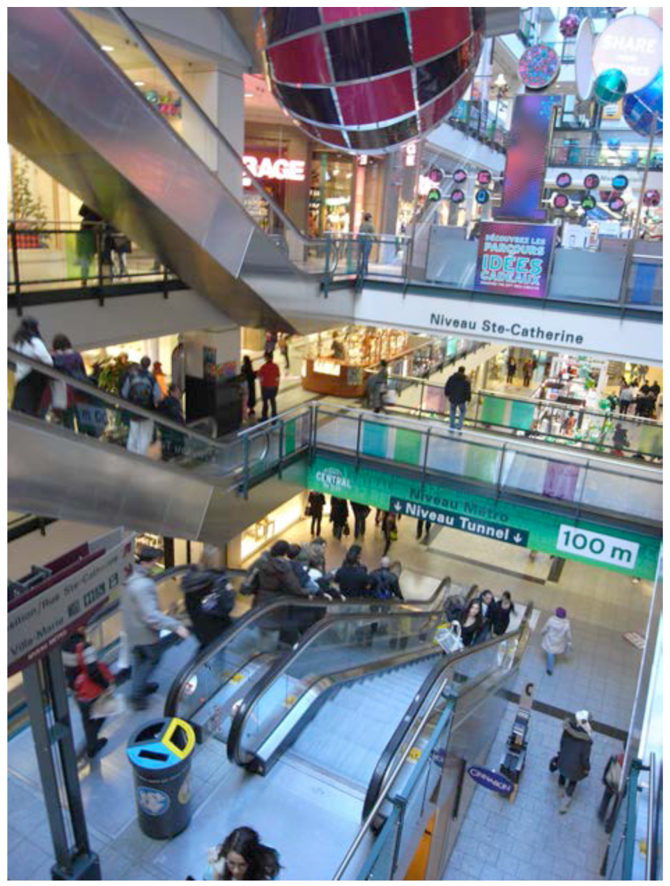
Although all of the early developments were commercial ventures, the system quickly came to have a number of purposes depending on time, place and specific user groups. In early morning, it is a relatively comfortable and fast way to get from mass rapid transit to the office, but at mid day transforms into a walking and shopping space as workers are freed from their workday schedules. In extreme cold weather and in the rain, it serves to protect pedestrians from the elements. On weekends, parts of the system become social spaces and the shopping system within the Underground is densely populated. The original plan did not allow housing in this business area. However, much of the new development above the Underground is in the form of housing, hotels and related services. Cultural institutions, convention centers and educational institutions have joined the network, further diversifying the uses.
The city did not implement a master plan for the Underground. Rather, it allowed private developers to propose links to the system. As these links proliferated, the city began to promote more linkage through management of all the building activity in the core area. The various disconnected parts of the Underground within the downtown area became a single connected system in the 2000 decade, with a large proportion of downtown buildings directly connected to the underground system (Figure 1). But many adjacent buildings positioned their entrances so that visitors could use the local streets to access the Underground.
The underground network essentially underlaid the street system with a second commercial layer connected with metro stations (Figure 2).
The question
To what extent does the layout of the Underground determine economic rents? Since the visit rate to a commercial space will be related to the generated economic activity, it follows that in general, higher visit rates are equivalent to higher rents. If the pedestrian volume in the corridor is closely related to the visit rate at the commercial outlets in the corridor, then we can know that the uses are dependent on flows.
The method
In this study, we conduct a study of pedestrian volume counts in 10 corridors in the Underground, along with simultaneous counts of visits to a set of stores within those corridors. We examine the relative significance of land use and pedestrian volume in the corridor as explanatory variables for the visit rates to the stores.
Analytical approach
The economic value of space in the Underground of Montréal is very closely related to the movement dynamics of the Underground system. This demonstration involves two sets of data: The pedestrian flow data are related to the rates at which those pedestrians visit the commercial spaces that line the network. Those pedestrian flows are also related to a sample of economic rents for underground spaces. Finally, the changes in the network over time also produced substantial land use changes in parts of the system, the explanation for which is largely in the changes in pedestrian flow, itself occasioned by the changes in network configuration. These statistical relationships provide evidence that social and economic activities are dependent on the configuration of the movement system.
2.2. Tokyo Station City
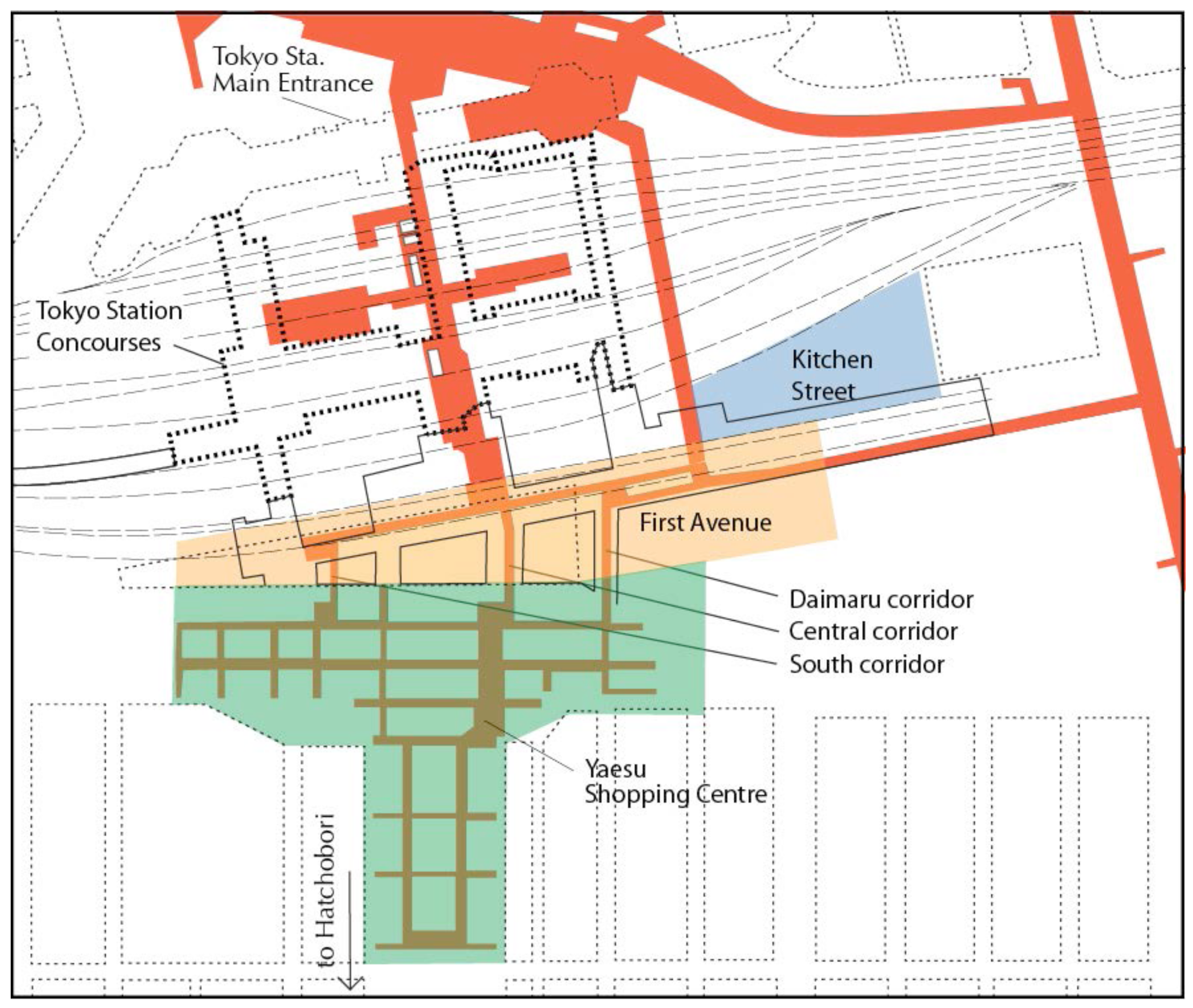
Urban areas around railway stations are new areas of major investment in Japan. The railway companies themselves have invested heavily in commercial operations related to their railway operations [19], in part because of regulatory changes that encouraged them to re-invest in the stations [20]. Private investment in commercial facilities adjacent to these new “station cities” has followed [21], increasing visitorship dramatically in some adjacent quarters. Tokyo Station has served as the major Tokyo hub for national lines since early development of the railway system in the 1920s. Following the privatization of the railways in the 1980s, several railway companies began to share the Tokyo station facility, eventually investing in their respective parts of the real estate associated with the station. The collective efforts of the four major stakeholders in the station—East Japan Railway Company, Central Japan Railway Company, Mitsubishi Corporation, Kajima Yaesu Development Company–have supported the development of the Tokyo Station City concept [22]. Tokyo Station is the most advanced case in Japan where the station facilities have been augmented with shopping, offices, convention and educational facilities.
From 2009, the companies involved in Tokyo Station have been building new links between their facilities, while adding new commercial and public space. These technically difficult links beneath high-speed rail tracks are expensive and have required seismic upgrading of the whole railway facility. The presumed outcome is that joining facilities will increase the overall agglomerative effect. More specifically, it is expected that sharing clienteles will result in more clients overall at each center. In the case discussed here, we measure the extent to which two adjacent centers share clienteles in the Tokyo station concourses: The Yaesu and First Avenue shopping centers (Figure 3) have recently been joined with three new links.
The question
To what extent does combining activity centers contribute to social and economic activity in each center?
The method
Pedestrian flow counts were conducted in the walking network in the Tokyo Station City development, at the key noon and late afternoon time frames. Flow direction was taken into account in order to derive directional flows from one center to another. An analysis of the resulting projected flows reveals to what extent the clienteles of these centers are shared.
Analytical approach
Recent developments in the Tokyo Station City development include new connections between parts of the complex owned by different companies. To the extent that these newly joined facilities capitalize on the presence of visitors in the adjacent centers and essentially increase the total patronage overall, we can identify the positive externalities associated with combining facilities. In this case, we analyze movement between the various parts of the Tokyo Station underground walking system.
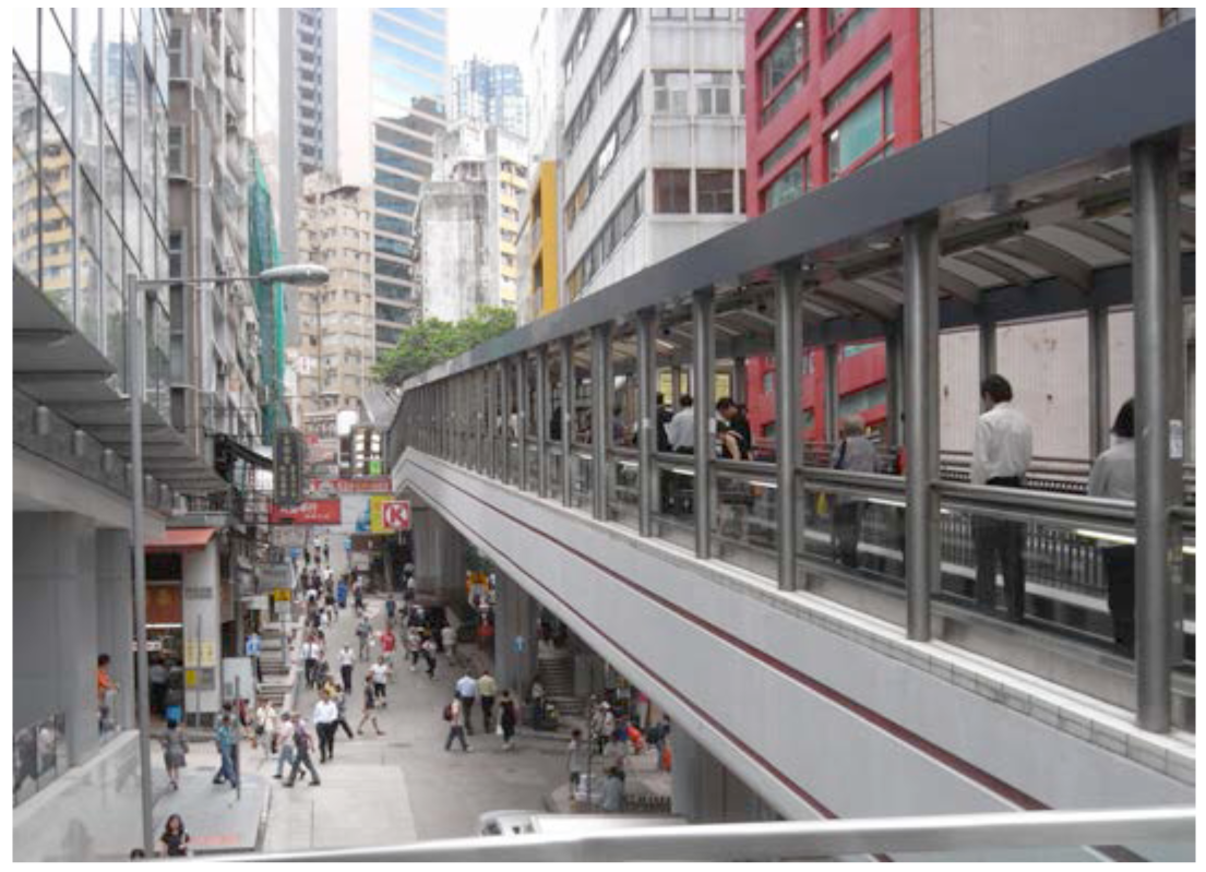
2.3. The Hong Kong Central Mid-levels Escalator
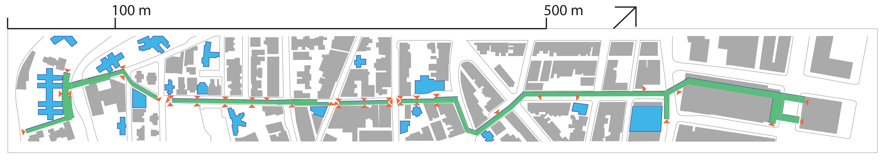
The Escalator in on Hong Kong Island was constructed by the Highways Department in 1994. Built to facilitate the movement of people up the steep slopes of Central, the Mid-levels escalator joined many other escalators that had come to characterize pedestrian movement in Hong Kong [23]. Hong Kong has given a lot of attention to pedestrian facilities, through purpose-building, as in the walkway system in Central and in an abundance of academic research on walking [24,25]. The escalator moves 45,000 people daily up and down the slope, a total vertical rise of 134 m, thus avoiding costly public transportation services, while conferring large increases in value on the properties at higher elevations. Today there are 55 buildings lining the escalator and street system for a total real estate value of nearly $3 billion USD. The escalator has permitted exceptionally high densities along its path, on average 9.3 times the surface area (Figure 4).
The Hong Kong escalator has given rise to a lot of debate about the social and personal implications of escalators in the transport system. Some view the escalators in Hong Kong as an extension of the organization of high-rise living into the public environment. In the view of the critics, escalators speed the passage of people through space, reduce communication among them and enable more intensive real estate development. Escalators reduce the tendency to use stairs and ramps in Hong Kong, which has obvious personal health implications [26]. However, in the case of the Mid-levels escalator, many more people travel to higher levels in Central than before its implementation. Not all travel is on the escalator—in part due to the design of the facility as a single track–with flows on the ramped streets and stairways below that in places rival the volumes on the escalator. Thus, the escalator is a mix of modernist intention and scaled-back engineering design, but also a vehicle for new social life and the catalyst for a new urban place.
The escalator and travelator, or moving sidewalk, moves up the slope with access points at the intersecting streets. Redevelopment occurred subsequently on properties adjacent the escalator corridor, with proposals to connect directly with the escalator at the upper level. Hong Kong government also promoted partnerships with private developers to expand the public space associated with the escalator. Finally, new uses came to occupy the commercial spaces on the street beneath the escalator, at the upper floor levels connectible to the escalator, and along the intersecting streets.
The method
Users of the escalator system were intercepted and asked to provide details on their present trip, in order to determine the spatial extent of the movement system connected with the hillside mechanical movement system. In a second study, the construction dates of buildings in the vicinity of the Escalator were investigated, along with a cross-sectional study of real estate transactions in the same area. These data reveal the extent to which the escalator system contributed to real estate activity.
Analytical approach
The number of travellers on the Mid-levels Escalator has continued to rise in recent years, as tourists make this a popular visit and as local venues open up along its length. In this case, it is the investment in new real estate along its length, in addition to the increased real estate transaction rate that provides evidence of the contribution of the escalator to local development. Central was one of the earliest developed urban areas on Hong Kong Island, immediately above the Star ferry terminal and the city's premier business hub. The extent to which the relatively recent escalator installation has contributed to a regeneration of this older area is evidence of the power of the escalator to promote urban development
3. Results
3.1. The Underground of Montreal
The ten corridors where observations were conducted contained 65 shopping outlets of a variety of types. The observations on flow and store entries were carried out until significant differences could be observed between locations. Land uses were categorized in the following way: All clothing stores and related clothing accessories were assigned to “clothing”. Food services, restaurants, cafés and wine stores were categorized as “food”. All other activities including travel agents, banks, beauty salons, drugstores and bookstores were categorized as ‘services’. The shopping rate at clothing stores was significantly higher than at food vendors and services although the difference in absolute terms is relatively small. Overall, the land use categories accounted for 6% of the variance in visits. In the case of Montréal, comparable to the other cases cited in this paper, the relationship between volume and store-hits is relatively strong and significant (r = 0.371; F = 16.2; p = 0.0001), assuming a linear relationship. There is an even stronger relationship when using a logarithmic regression analysis on the Montreal data (r = 0.556; t = 8.255; p < 0.0001). Thus, the proportion of variance in store hits explained by corridor pedestrian volume is 13.8% in Montreal. The effect size of the sample relationship between volume and store-hits is .69 (r = 0.05), constituting a large effect, though the actual figure is small in absolute terms.
We can conclude that land uses and commercial rents are impacted by the pedestrian flow in the adjacent corridor. The uses themselves have substantially less effect, if any, on corridor flow. So the Underground system has a powerful impact on the economic structure of commercial retailing in central Montréal.
3.2. Tokyo Station City
The First Avenue project is inserted between a previously operating Yaesu shopping complex, Kitchen Street and the Mitsubishi underground complex to the west of the station. Before this link was completed, it was necessary to pass through station space without services to go from one shopping and services center to another.
Altogether, the three new corridors from First Avenue to the Yaesu shopping center account for 31.4% of the presence in the Yaesu shopping complex. The addition of two major towers at opposite ends of the station, provides substantial flows through the new system into all of the shopping centers. Flow from the Yaesu side through the Daimaru corridor accounts for 6.0% of all the walking pedestrians in the public areas of the Station, while the Central corridor accounts for 15.0%. The South corridor accounts for 7.3% of the flow in the Station corridors. As can be seen from all the above, the flows from Yaesu to the Station and in reverse are more or less equal.
3.3. The Hong Kong Mid-Levels Escalator
The real estate activity enabled and promoted by the escalator infrastructure is considerable. In a real estate study conducted by the author with Professor Laurence Liauw of Hong Kong University, it was seen that the total amount of real estate transactions over time spiked within the first 60 m of the escalator, then dropping to about half the transaction rate at 80 m or more of distance. The available sites at the higher levels were developed quickly after the opening of the escalator and generally at higher densities than at the lower levels. In the last decade, the development activity has moved down the slope to the mid-level, where traditionally small sites have been redeveloped as residential point towers with commercial bases. The commercial activities at the ground and mezzanine level often exploit the two-level connection to the street and to the escalator and offer public-oriented commercial venues. A third wave of redevelopment is currently projected for the lower reaches, in association with the re-use of the Central Market.
The escalator has also contributed to the revitalization of the transversal streets (Figure 5). Visits to these streets reveal the number of new social venues and specialized business activities. In an interview study conducted with 160 users of the escalator, it was seen that the great majority of the individuals had origins or destinations in their walks along one of the 15 streets that cross the escalator-street system. The reported destinations were located on average at 95 m from an escalator entrance. One-third of the destinations (33%) were within 50 m of an escalator entrance, but a surprisingly high proportion of visits (21%) were to locations more than 150 m from the escalator. The reasons given for the trip on the escalator were varied and often complex with more than one purpose or destination. In the sample of interviewees, those heading to home were a small proportion. Although the proportion of escalator travellers who live in the immediate area varies over the day, it is no exaggeration to say that the uses of the escalator have diversified from commuting.
The escalator provides the fastest way to reach the highest elevations of the urbanized area of all the travel means available. The time to travel to the top while walking on the moving escalator is 20 minutes. A taxi takes 27 minutes and costs $36 HKD. The No. 3 minibus takes 32 minutes to reach the top from its station at the bottom, while the standard size No. 3B bus takes 38 minutes. Walking up the streets without the help of the escalator—for example, during the morning when the escalator is travelling downhill —takes 45 minutes at a normal, but fairly demanding pace. Clearly, the fastest way to reach the top is to walk on the escalator, which is what the very great majority of users do. Moreover, users can obtain a public transport credit for using the escalator, since it is much cheaper for the transport authority to move passengers uphill on the escalator than to move them by bus. For example, the energy cost for moving one individual from end to end of the system is 0.5 US cent.
Most significantly for the city, the escalator has come to be known as the access to interesting and unique venues that line the steep connecting streets and now also invest some of the crossing streets. It is widely considered as a unique place that emerged out of a hodge-podge of small buildings and streets that first occupied the lower slopes of Central. Personal services began to occupy the second levels while the ground floors were taken up with cafés, bars and restaurants. The multiple forms of movement—escalator, stairs, ramps and vehicle movement on the cross streets—confer a feeling of center on this strip up the hillside. Is the escalator a commuting aid or a social venue? The means are becoming less clear with time, as the commercial activities spread out from the spine itself, more tourists visit and the urban planners negotiate improvements in the facilities with private investors. In the meantime, the escalator is the primary means of travel for tens of thousands of Hong Kong residents living in the Mid-levels but working in Central.
The Highways Department mandate was the development of a movement system that helped resolve the accessibility problems to the higher elevations of Central on Hong Kong Island. The system remained open-ended in promoting as many connections to the urban environment as possible and allowing the extension of the reach of the facility. At the time of implementation, it was apparently not foreseen that there would be several waves of successive development that made the system much more complex and its meanings rather ambiguous. But it is precisely these outcomes that is now attracting new social venues to Central slopes and inspiring similar escalator projects in other parts of Hong Kong Island. Obviously, the escalator is a unique response to a particular geographical and urban context. It nevertheless is suggestive of other forms of basic movement infrastructure that could be used to grow urban environments in quite different urban circumstances.
4. Discussion
A major theme of advanced city development in our time is place creation, supported by infrastructure provision [27]. Such places vary considerably by city and locality and take on forms congruent with local geography and cultural markers. Cities may look to such place creation programs as a means to support places of exchange, communication and cultural representation. Local planning and transport infrastructure, in particular, can be marshaled in support of place, where the civic input remains largely at the level of the infrastructure, not in the programming. Ongoing, inward investment in such places occurs as demand rises for central locations with polyvalent meaning and flexible structures.
In the three cases illustrated here, decisive steps were taken at a particular time that created the conditions for inward investment in commerce, social activity and exchange. In Hong Kong, it was the Highways Department decision to build a single elevator and travelator track in the densest part of Central, in 1994. In Montreal, the decision of the urban planners to build the metro system so that it would connect with a continuous underground floor, mostly just above the station concourses, led to the spontaneous expansion of the whole system. In Tokyo, the critical decision can be traced to the design of the JR station in the 1920s, when the JR tracks were laid north-south at ground level, which then required overhead and underground pedestrian passageways to access the platforms. These passageways connected immediately to the ground level at the north-east side of the station, and at an elevated level at the south and south-east entrances, adjacent to the adjoining area.
In all cases, the city authorities preferred strategic and high-level intervention, rather than master planning or control at plot level. The distributed ownership of lands around these systems allowed the incremental transformation with many, small interventions. In this way, the land uses transformed over time and combined multiple uses within the same area or within the same building structure. The areas became known as important centers in the city, with particular character and particular potential. In contemporary times, each of these cities has begun to champion their respective successes as emblematic of their cities and a source of new development potential.
These cases underscore the importance of activity synergy, open-ended infrastructure, an attention to place quality, public space of high quality and the welcoming of private initiative. Further investigations should focus on how such areas are perceived by users and investors. City governments will be interested in how to adapt such programs to their own purposes.
5. Conclusion
This paper set out to show how movement infrastructure, particularly at the local level of movement, exchange and activity in cities, has powerful effects on the subsequent patterns of development. Although planning has often considered that such infrastructure for moving people is a support for building cities, it is seldom seen as a vital building tool in its own right. That is, fundamental decisions with regard to the type of facility and its particular implementation in the local environment may have significant impact on the type of development to follow, the speed with which it occurs and how much development takes place.
The three cases considered three different types of infrastructure in three quite different city and regional contexts. The Underground system is an indoor pedestrian network connecting together most large buildings in the downtown of Montréal. The Mid-levels Escalator serves a residential area adjacent to the city core. The Tokyo Station City project is a movement, shopping and services network built around a major railway station.
In the case of the Underground it was seen that it is the network itself, with its variable levels of pedestrian flow that is the single, major determinant of land uses and economic rents on its corridors. It is the major structuring element for the retailing core of the city. The Tokyo Station study considered the distributed benefits of linking together the various parts of the movement network of the station. It was shown that by linking together such a network and creating a greater whole, the individual parts benefit through a sharing of clienteles. Finally, the Mid-levels Escalator considered such movement infrastructure as a system for real estate development. There was accelerated development in the parts of the neighborhood that previously were difficult to access. The new developments were at higher density than previous developments, while many new uses also visited the spaces around the infrastructure. The Escalator had a considerable role in the real estate regeneration observable in this case.
Overall, we can point to such public movement infrastructure as an economic development tool. The system was started in response to an obvious need in each of the cases, but soon also became an opportunity beyond the limits of the original project to move people efficiently and comfortably. In the Montréal and Hong Kong cases, the layout of the system was clearly designed in an open-ended way, with multiple connections to the rest of the urban fabric. In the Tokyo case, a physically constrained site nevertheless revealed opportunities to connect with the surface environment and to connect together the various parts of the station area, with much the same effect. The systems are open-ended, to allow for further projects, while diversifying the program of the whole area. Such approaches are not all that usual in the urban design of many contemporary projects, where the emphasis is often on carefully defined, closed systems and an overall set design.


References
- Léo, P.-Y.; Philippe, J. Retail centres: Location and consumer's satisfaction. Service Industries 2002, 22, 122–146. [Google Scholar]
- Bourdieu, P. The Social Structures of the Economy; Polity Press: Cambridge, UK, 2005. [Google Scholar]
- Rapoport, A.; Kantor, R.E. Complexity and ambiguity in environmental design. JAIP 1967, 33, 210–221. [Google Scholar]
- Brown, S. Retail Location: A Micro-Scale Perspective; Avebury: Aldershot, UK, 1992. [Google Scholar]
- Jones, K. Location, Location, Location: How to Select The Best Site for Your Retail Business; Nelson: Toronto, Canada, 1993. [Google Scholar]
- Brown, R. Private Real Estate Investment: Data Analysis and Decision Making; Elsevier Academic Press: Boston, MA, USA, 2005. [Google Scholar]
- Golledge, R. Analytical Behavioural Geography; Croom Helm: London, UK, 1987. [Google Scholar]
- Golledge, R. Behavior and Environment: Psychological and Geographical Approaches; North Holland Publishers: Amsterdam, The Netherlands, 1993. [Google Scholar]
- Howkins, J. The Creative Economy: How People Make Money from Ideas; Allen Lane: London, UK, 2001. [Google Scholar]
- Wong, T.-C. The changing role of the central business district in the digital era: The future of Singapore's new financial district. Land Use Policy 2004, 21, 33–44. [Google Scholar]
- Sassen, S. Cities in A World Economy, 2nd ed.; Pine Forge Press: Thousand Oaks, CA, USA, 2000. [Google Scholar]
- Storper, M. The Regional World: Territorial Development in A Global Economy; The Guilford Press: New York, NY, USA, 1997. [Google Scholar]
- Christaller, W. Central Places in Southern Germany; Prentice Hall: Upper Saddle River, NJ, USA, 1966. [Google Scholar]
- Golledge, R. Behavior and Environment: Psychological and Geographical Approaches; North Holland Publishers: Amsterdam, The Netherlands, 1993. [Google Scholar]
- Cervero, R.; Gorham, R. Commuting in transit versus automobile neighborhoods. J. Am. Plann. Assoc. 1995, 61, 210–225. [Google Scholar]
- Greenwald, M.J.; Boarnet, M. Built environment as determinant of walking behavior: Analyzing nonwork pedestrian travel in Portland, Oregon. Transp. Res. Record 2000, 1780, 33–42. [Google Scholar]
- Kitamura, R.; Laidet, I.; Mokhtarian, P. A micro-analysis of land use and travel in five neighborhoods in the San Francisco Bay Area. Transportation 1997, 24, 125–158. [Google Scholar]
- Besner, J. Montréal Underground: A model of partnership. Actualité Immobilière 1991, 15, 12–18. [Google Scholar]
- Ieda, H.; Kanayama, Y.; Ota, M.; Yamazaki, T.; Okamura, T. How can the quality of rail services in Tokyo be further improved? Transp. Policy 2001, 8, 97–106. [Google Scholar]
- Kanemoto, Y.; Kyono, K. Regulation of commuter railways and spatial development. Reg. Sci. Urban Econ. 1995, 25, 377–394. [Google Scholar]
- Yoshida, H. On the development of Tokyo Station City, Ishizue. Japan Build. Manag. Inst. Bull. 2007, 131, 3–7. (in Japanese). [Google Scholar]
- Zacharias, J.; Zhang, T.; Nakajima, N. Tokyo Station City—The railway station as urban place. Urban Des. Int. 2011, 16, 242–251. [Google Scholar]
- Siu, K.W.M. The escalator: A conveyer of Hong Kong's culture. Hum. Relat. 1999, 52, 665–681. [Google Scholar]
- Lam, W.H.K.; Cheung, C.-Y. Pedestrian speed/flow relationships for walking facilities in Hong Kong. J. Transport. Eng. 2000, 126, 343–349. [Google Scholar]
- Wu, Z.X.; Lam, W.H.K.; Chan, K.S. Multi-modal network design: Selection of pedestrianisation location. J. East Asia Soc. Transp. Stud. 2005, 6, 2275–2290. [Google Scholar]
- Eves, F.F.; Masters, R.S.W.; Momanus, A.; Leung, M.; Wong, P.; White, M.J. Contextual barriers to lifestyle physical activity interventions in Hong Kong. Med. Sci. Sport Exer. 2008, 40, 965–971. [Google Scholar]
- Imrie, R.; Lees, L.; Raco, M. Regenerating London: Governance, Sustainability and Community in A Global City; Routledge: London, UK, 2008. [Google Scholar]
© 2011 by the authors; licensee MDPI, Basel, Switzerland. This article is an open access article distributed under the terms and conditions of the Creative Commons Attribution license (http://creativecommons.org/licenses/by/3.0/).
Share and Cite
Zacharias, J. The Dynamics of People Movement Systems in Central Areas. Challenges 2011, 2, 94-108. https://doi.org/10.3390/challe2040094
Zacharias J. The Dynamics of People Movement Systems in Central Areas. Challenges. 2011; 2(4):94-108. https://doi.org/10.3390/challe2040094
Chicago/Turabian StyleZacharias, John. 2011. "The Dynamics of People Movement Systems in Central Areas" Challenges 2, no. 4: 94-108. https://doi.org/10.3390/challe2040094