An Application of Sentinel-1, Sentinel-2, and GNSS Data for Landslide Susceptibility Mapping

 ,
, 
 ,
, 
 and
and 
Abstract
1. Introduction
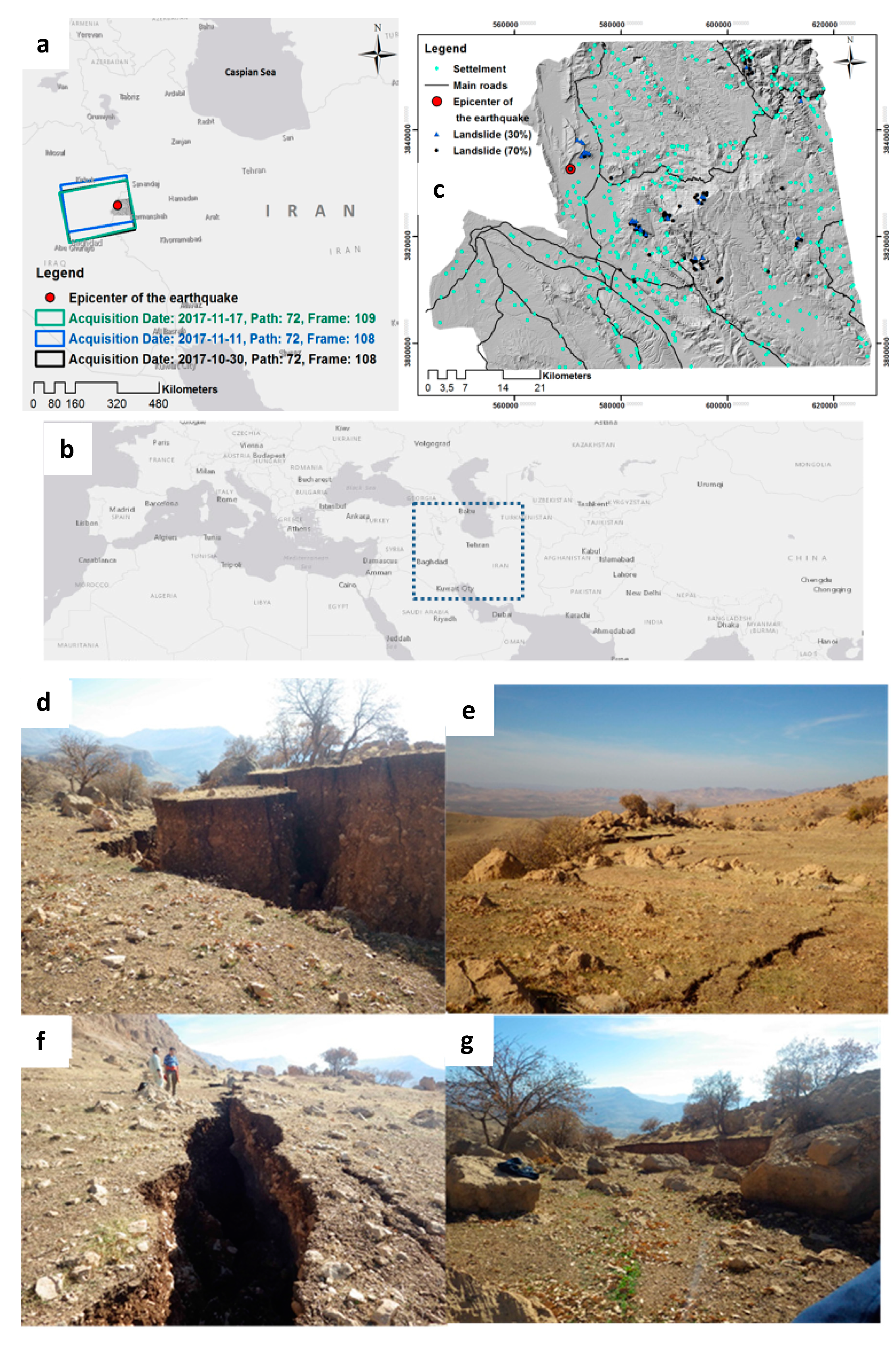
2. Overview of the Study Area
3. Workflow
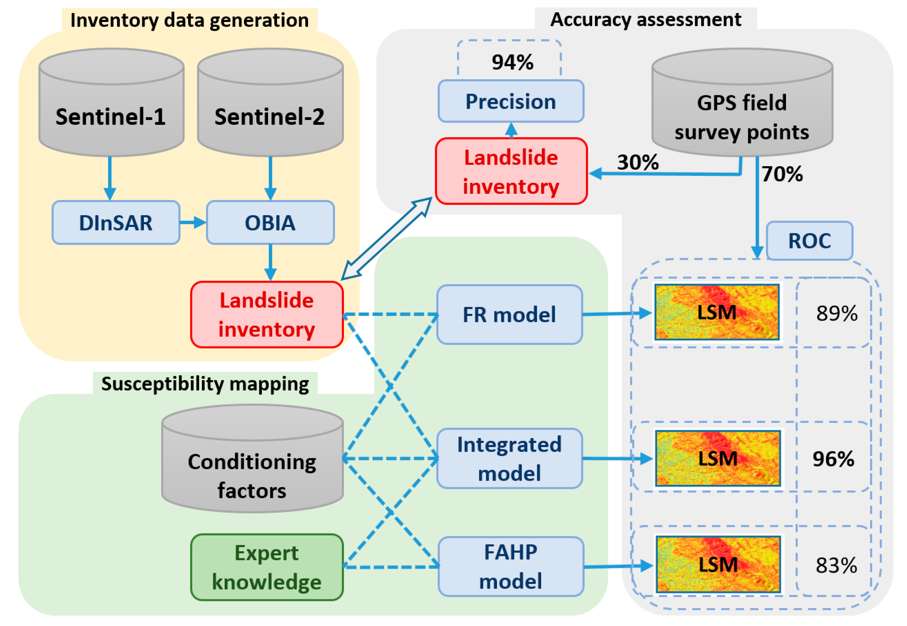
3.1. Overall Methodology
- ▪
- Landslide inventory generation: we applied Sentinel-1A and Sentinel-2B images to detect the earthquake-induced landslides using DInSAR interference and OBIA.
- ▪
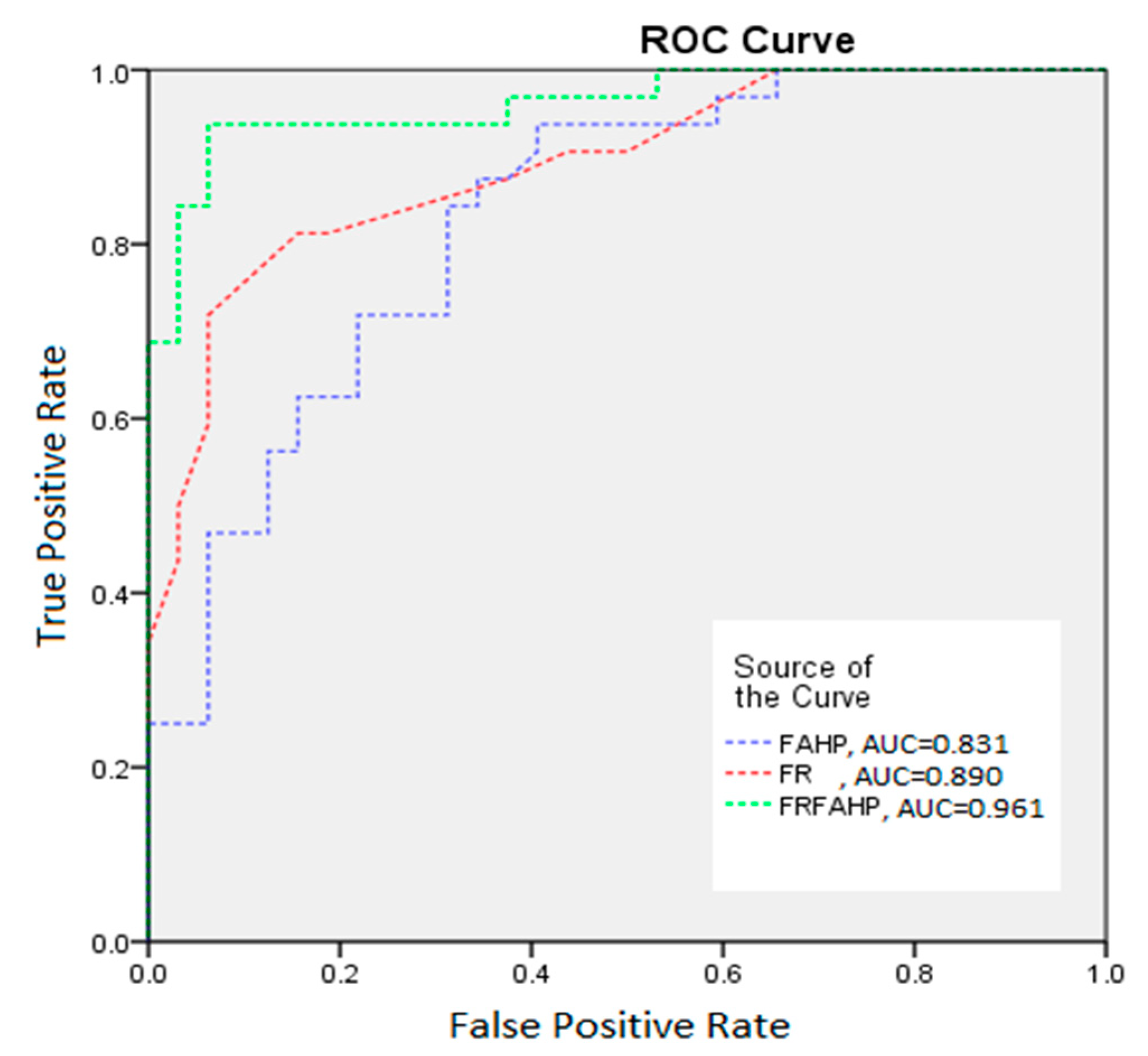
- Landslide susceptibility mapping: a) we collected and prepared all conditioning factors for further susceptibility analyses; b) we applied the FR and fuzzy AHP (FAHP) models for LSM using the resulting landslide inventory and expert knowledge, respectively; c) we integrated the resulting weights of the FAHP model for each conditioning factor with the FR model for each class of each conditioning factor to produce a new LSM.
- ▪
- Accuracy assessment: we collected GPS points in an extensive field survey and randomly divided the points into 30% and 70% for validating the resulting landslide inventory dataset and the performance of each model, respectively.
3.2. Landslide Inventory Dataset Generation
3.2.1. The Differential Synthetic Aperture Radar Interferometry (DInSAR)
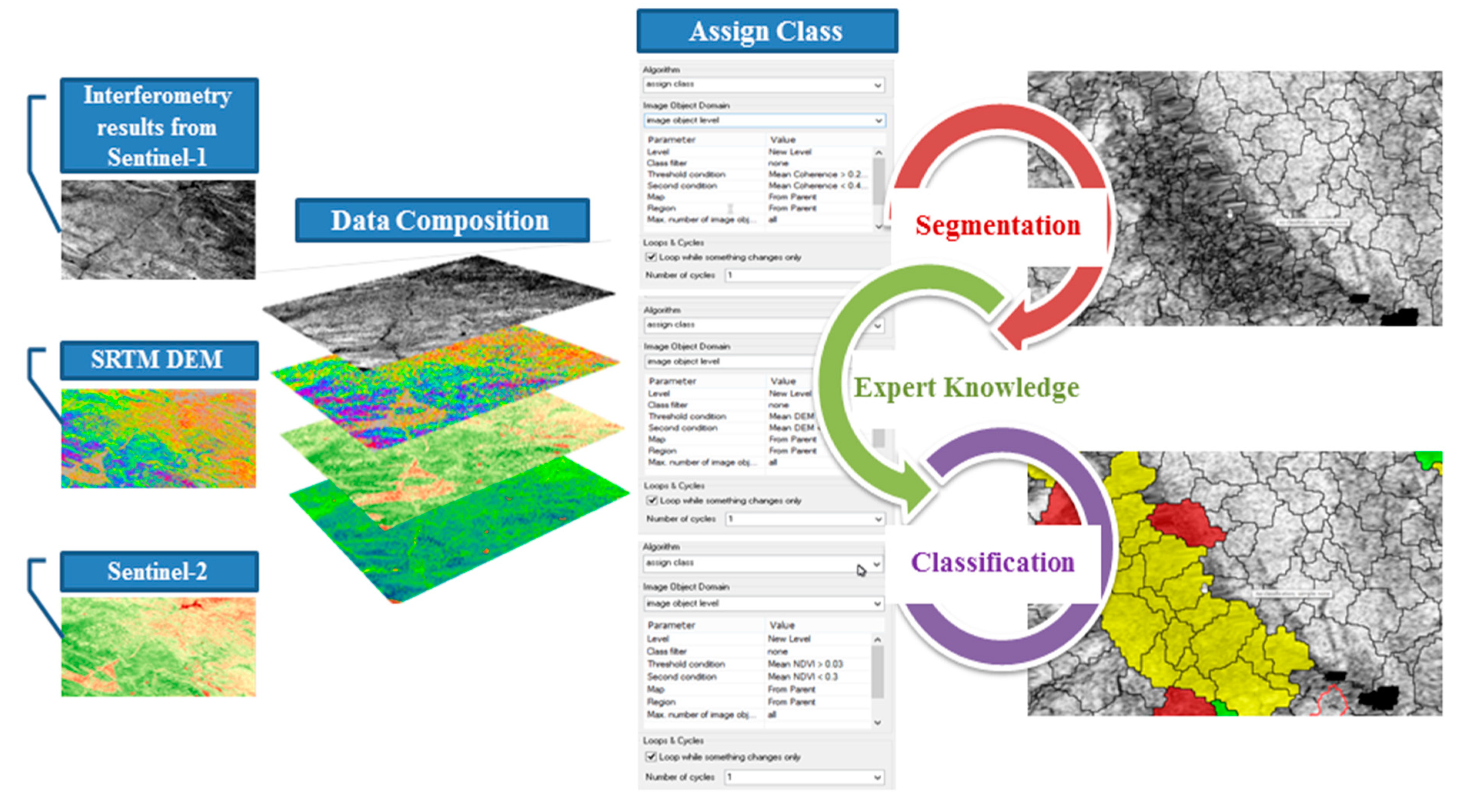
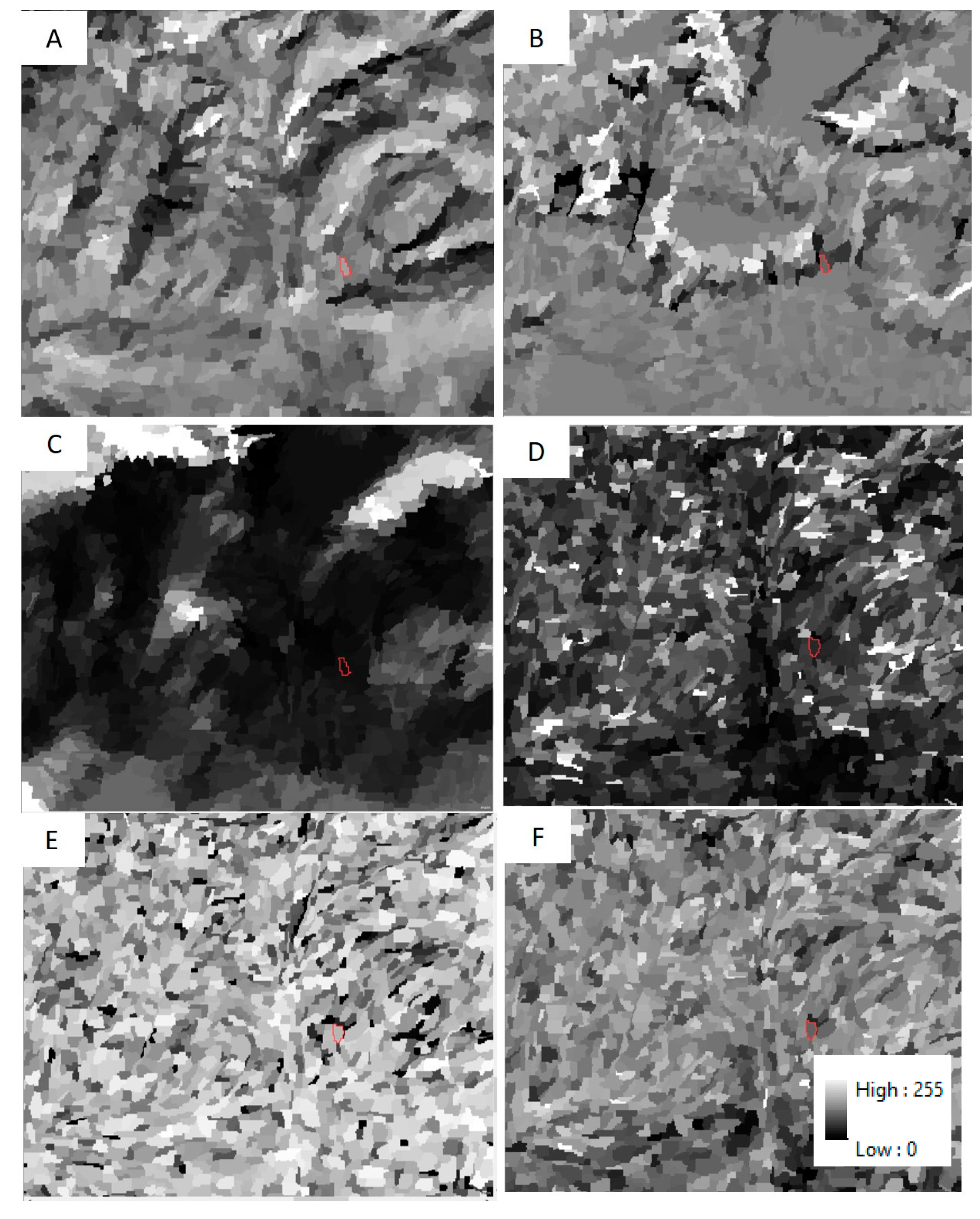
3.2.2. Object-Based Image Analysis (OBIA)
3.3. Landslide Susceptibility Mapping
3.3.1. Conditioning Factors
3.3.2. Frequency Ratio (FR)
3.3.3. Fuzzy AHP
3.3.4. Integrated Model
4. Results
4.1. Resulting Landslide Inventory Dataset
4.2. Resulting Landslide Susceptibility Maps
5. Accuracy Assessment
5.1. Validation of the Resulting Landslide Inventory Dataset
5.2. Validation of Resulting LSMs
6. Discussion
7. Conclusions
Author Contributions
Funding
Acknowledgments
Conflicts of Interest
Abbreviations
| DInSAR | differential synthetic aperture radar interferometry |
| SAR | synthetic aperture radar |
| OBIA | object-based image analysis |
| FR | frequency ratio |
| GIS | geographic information system |
| LSM | landslide susceptibility mapping |
| GPS | global positioning system |
| AHP | analytic hierarchy process |
| ANP | analytic network process |
| OWA | order weighted average |
| WLC | weighted linear combination |
| DEM | digital elevation model |
| NDVI | normalised difference vegetation index |
| GLCM | grey level co-occurrence matrix |
| FAHP | fuzzy AHP |
| ROC | receiver operating characteristics |
| TPR | true positive rate |
| FPR | False-positive rate |
| AUC | the area under the curve |
References
- Hong, H.; Pourghasemi, H.R.; Pourtaghi, Z.S. Landslide susceptibility assessment in Lianhua County (China): A comparison between a random forest data mining technique and bivariate and multivariate statistical models. Geomorphology 2016, 259, 105–118. [Google Scholar] [CrossRef] [Scilit]
- Mondal, S.; Maiti, R. Integrating the analytical hierarchy process (AHP) and the frequency ratio (FR) model in landslide susceptibility mapping of Shiv-khola watershed, Darjeeling Himalaya. Int. J. Disaster Risk Sci. 2013, 4, 200–212. [Google Scholar] [CrossRef] [Scilit]
- Shirvani, Z. A Holistic Analysis for Landslide Susceptibility Mapping Applying Geographic Object-Based Random Forest: A Comparison between Protected and Non-Protected Forests. Remote Sens. 2020, 12, 434. [Google Scholar] [CrossRef] [Scilit]
- Pourghasemi, H.R.; Rahmati, O. Prediction of the landslide susceptibility: Which algorithm, which precision? Catena 2018, 162, 177–192. [Google Scholar] [CrossRef] [Scilit]
- Casagli, N.; Cigna, F.; Bianchini, S.; Hölbling, D.; Füreder, P.; Righini, G.; Del Conte, S.; Friedl, B.; Schneiderbauer, S.; Iasio, C. Landslide mapping and monitoring by using radar and optical remote sensing: Examples from the EC-FP7 project SAFER. Remote Sens. Appl. Soc. Environ. 2016, 4, 92–108. [Google Scholar] [CrossRef] [Scilit]
- Lanari, R.; Berardino, P.; Bonano, M.; Casu, F.; Manconi, A.; Manunta, M.; Manzo, M.; Pepe, A.; Pepe, S.; Sansosti, E. Surface displacements associated with the L’Aquila 2009 Mw 6.3 earthquake (central Italy): New evidence from SBAS-DInSAR time series analysis. Geophys. Res. Lett. 2010, 37. [Google Scholar] [CrossRef] [Scilit]
- Dabiri, Z.; Hölbling, D.; Abad, L.; Helgason, J.K.; Sæmundsson, Þ.; Tiede, D. Assessment of Landslide-Induced Geomorphological Changes in Hítardalur Valley, Iceland, Using Sentinel-1 and Sentinel-2 Data. Appl. Sci. 2020, 10, 5848. [Google Scholar] [CrossRef] [Scilit]
- Goorabi, A. Detection of landslide induced by large earthquake using InSAR coherence techniques–Northwest Zagros, Iran. Egypt. J. Remote Sens. Space Sci. 2019, 23, 195–205. [Google Scholar] [CrossRef] [Scilit]
- Hölbling, D.; Füreder, P.; Antolini, F.; Cigna, F.; Casagli, N.; Lang, S. A semi-automated object-based approach for landslide detection validated by persistent scatterer interferometry measures and landslide inventories. Remote Sens. 2012, 4, 1310–1336. [Google Scholar] [CrossRef] [Scilit]
- Shirvani, Z.; Abdi, O.; Buchroithner, M. A Synergetic Analysis of Sentinel-1 and-2 for Mapping Historical Landslides Using Object-Oriented Random Forest in the Hyrcanian Forests. Remote Sens. 2019, 11, 2300. [Google Scholar] [CrossRef] [Scilit]
- Tavakkoli Piralilou, S.; Shahabi, H.; Jarihani, B.; Ghorbanzadeh, O.; Blaschke, T.; Gholamnia, K.; Meena, S.R.; Aryal, J. Landslide Detection Using Multi-Scale Image Segmentation and Different Machine Learning Models in the Higher Himalayas. Remote Sens. 2019, 11, 2575. [Google Scholar] [CrossRef] [Scilit]
- Ghorbanzadeh, O.; Blaschke, T.; Gholamnia, K.; Meena, S.R.; Tiede, D.; Aryal, J. Evaluation of Different Machine Learning Methods and Deep-Learning Convolutional Neural Networks for Landslide Detection. Remote Sens. 2019, 11, 196. [Google Scholar] [CrossRef] [Scilit]
- Sameen, M.I.; Pradhan, B. Landslide Detection Using Residual Networks and the Fusion of Spectral and Topographic Information. IEEE Access 2019, 7, 114363–114373. [Google Scholar] [CrossRef] [Scilit]
- Karimzadeh, S. Characterization of land subsidence in Tabriz basin (NW Iran) using InSAR and watershed analyses. Acta Geod. Geophys. 2016, 51, 181–195. [Google Scholar] [CrossRef] [Scilit]
- Jelének, J.; Kopačková, V.; Fárová, K. Post-earthquake landslide distribution assessment using sentinel-1 and-2 data: The example of the 2016 mw 7.8 earthquake in New Zealand. In Proceedings of the 2nd International Electronic Conference on Remote Sensing, Online Conference, 22 March–5 April 2017; p. 361. [Google Scholar]
- Ghorbanzadeh, O.; Feizizadeh, B.; Blaschke, T. Multi-criteria risk evaluation by integrating an analytical network process approach into GIS-based sensitivity and uncertainty analyses. Geomat. Nat. Hazards Risk 2018, 9, 127–151. [Google Scholar] [CrossRef] [Scilit]
- Zare, M.; Pourghasemi, H.R.; Vafakhah, M.; Pradhan, B. Landslide susceptibility mapping at Vaz Watershed (Iran) using an artificial neural network model: A comparison between multilayer perceptron (MLP) and radial basic function (RBF) algorithms. Arab. J. Geosci. 2013, 6, 2873–2888. [Google Scholar] [CrossRef] [Scilit]
- Ghorbanzadeh, O.; Blaschke, T.; Aryal, J.; Gholaminia, K. A new GIS-based technique using an adaptive neuro-fuzzy inference system for land subsidence susceptibility mapping. J. Spat. Sci. 2018, 94, 1–17. [Google Scholar] [CrossRef] [Scilit]
- Günther, A.; Van Den Eeckhaut, M.; Malet, J.-P.; Reichenbach, P.; Hervás, J. Climate-physiographically differentiated Pan-European landslide susceptibility assessment using spatial multi-criteria evaluation and transnational landslide information. Geomorphology 2014, 224, 69–85. [Google Scholar] [CrossRef] [Scilit]
- Chen, J.; Yang, Y. A fuzzy ANP-based approach to evaluate region agricultural drought risk. Procedia Eng. 2011, 23, 822–827. [Google Scholar] [CrossRef] [Scilit]
- Malczewski, J. GIS-based land-use suitability analysis: A critical overview. Prog. Plan. 2004, 62, 3–65. [Google Scholar] [CrossRef] [Scilit]
- Pourghasemi, H.R.; Pradhan, B.; Gokceoglu, C. Application of fuzzy logic and analytical hierarchy process (AHP) to landslide susceptibility mapping at Haraz watershed, Iran. Nat. Hazards 2012, 63, 965–996. [Google Scholar] [CrossRef] [Scilit]
- Ahmed, B. Landslide susceptibility modelling applying user-defined weighting and data-driven statistical techniques in Cox’s Bazar Municipality, Bangladesh. Nat. Hazards 2015, 79, 1707–1737. [Google Scholar] [CrossRef] [Scilit]
- Shahabi, H.; Hashim, M. Landslide susceptibility mapping using GIS-based statistical models and Remote sensing data in tropical environment. Sci. Rep. 2015, 5, 9899. [Google Scholar] [CrossRef] [Scilit] [PubMed]
- Feizizadeh, B.; Jankowski, P.; Blaschke, T. A GIS based spatially-explicit sensitivity and uncertainty analysis approach for multi-criteria decision analysis. Comput. Geosci. 2014, 64, 81–95. [Google Scholar] [CrossRef] [Scilit] [PubMed]
- Ligmann-Zielinska, A.; Jankowski, P. Spatially-explicit integrated uncertainty and sensitivity analysis of criteria weights in multicriteria land suitability evaluation. Environ. Model. Softw. 2014, 57, 235–247. [Google Scholar] [CrossRef] [Scilit]
- Liu, F. Acceptable consistency analysis of interval reciprocal comparison matrices. Fuzzy Sets Syst. 2009, 160, 2686–2700. [Google Scholar] [CrossRef] [Scilit]
- Ghorbanzadeh, O.; Feizizadeh, B.; Blaschke, T. An interval matrix method used to optimize the decision matrix in AHP technique for land subsidence susceptibility mapping. Environ. Earth Sci. 2018, 77, 584. [Google Scholar] [CrossRef] [Scilit]
- Razandi, Y.; Pourghasemi, H.R.; Neisani, N.S.; Rahmati, O. Application of analytical hierarchy process, frequency ratio, and certainty factor models for groundwater potential mapping using GIS. Earth Sci. Inform. 2015, 8, 867–883. [Google Scholar] [CrossRef] [Scilit]
- IRSC. Iranian National Seismic Center Institute of Geophysics, University of Tehran. The Reports of Latest Earthquakes in Iran and Adjoining Areas. 2017. Available online: http://irsc.ut.ac.ir (accessed on 5 December 2017).
- IRIS. The Incorporated Research Institutions for Seismology Education & Public Outreach and the University of Portland. 2017. Available online: www.iris.edu/earthquake (accessed on 12 November 2017).
- Vajedian, S.; Motagh, M.; Mousavi, Z.; Motaghi, K.; Fielding, E.; Akbari, B.; Wetzel, H.-U.; Darabi, A. Coseismic deformation field of the Mw 7.3 12 November 2017 Sarpol-e Zahab (Iran) earthquake: A decoupling horizon in the northern Zagros Mountains inferred from InSAR observations. Remote Sens. 2018, 10, 1589. [Google Scholar] [CrossRef] [Scilit]
- Allen, M.B.; Armstrong, H.A. Arabia–Eurasia collision and the forcing of mid-Cenozoic global cooling. Palaeogeogr. Palaeoclim. Palaeoecol. 2008, 265, 52–58. [Google Scholar] [CrossRef] [Scilit]
- McQuarrie, N. Crustal scale geometry of the Zagros fold–thrust belt, Iran. J. Struct. Geol. 2004, 26, 519–535. [Google Scholar] [CrossRef] [Scilit]
- Mezaal, M.; Pradhan, B.; Rizeei, H. Improving Landslide Detection from Airborne Laser Scanning Data Using Optimized Dempster–Shafer. Remote Sens. 2018, 10, 1029. [Google Scholar] [CrossRef] [Scilit]
- Valkaniotis, S.; Foumelis, M.; De Michele, M.; Ganas, A.; Papathanassiou, G. Three-dimensional displacement field of a large co-seismic landslide (2017 Iraq-Iran earthquake) using optical-image correlation and SAR pixel offset-tracking. In Proceedings of the 9th International INQUA Meeting on Paleoseismology, Active Tectonics and Archeoseismology (PATA), Possidi, Greece, 25–27 June 2018. [Google Scholar]
- Kobayashi, T.; Morishita, Y.; Yarai, H.; Fujiwara, S. InSAR-derived Crustal Deformation and Reverse Fault Motion of the 2017 Iran-Iraq Earthquake in the Northwestern Part of the Zagros Orogenic Belt. Bull. Geospat. Inf. Auth. Jpn. 2019, 66, 1–9. [Google Scholar]
- Marbouti, M.; Praks, J.; Antropov, O.; Rinne, E.; Leppäranta, M. A Study of Landfast Ice with Sentinel-1 Repeat-Pass Interferometry over the Baltic Sea. Remote Sens. 2017, 9, 833. [Google Scholar] [CrossRef] [Scilit]
- Jiang, H.; Pei, Y.; Li, J. Sentinel-1 TOPS interferometry for along-track displacement measurement. In IOP Conference Series: Earth and Environmental Science; IOP Publishing: Bristol, UK, 2017; p. 012019. [Google Scholar]
- Hsieh, C.-S.; Shih, T.-Y.; Hu, J.-C.; Tung, H.; Huang, M.-H.; Angelier, J. Using differential SAR interferometry to map land subsidence: A case study in the Pingtung Plain of SW Taiwan. Nat. Hazards 2011, 58, 1311–1332. [Google Scholar] [CrossRef] [Scilit]
- Goldstein, R.M.; Werner, C.L. Radar interferogram filtering for geophysical applications. Geophys. Res. Lett. 1998, 25, 4035–4038. [Google Scholar] [CrossRef] [Scilit]
- Feng, Q.; Xu, H.; Wu, Z.; You, Y.; Liu, W.; Ge, S. Improved Goldstein Interferogram Filter Based on Local Fringe Frequency Estimation. Sensors 2016, 16, 1976. [Google Scholar] [CrossRef] [Scilit]
- Feizizadeh, B.; Blaschke, T.; Tiede, D.; Moghaddam, M.H.R. Evaluating fuzzy operators of an object-based image analysis for detecting landslides and their changes. Geomorphology 2017, 293, 240–254. [Google Scholar] [CrossRef] [Scilit]
- Feizizadeh, B. A Novel Approach of Fuzzy Dempster–Shafer Theory for Spatial Uncertainty Analysis and Accuracy Assessment of Object-Based Image Classification. IEEE Geosci. Remote Sens. Lett. 2018, 15, 18–22. [Google Scholar] [CrossRef] [Scilit]
- Mohammadi, M. Mass Movement Hazard Analysis and Presentation of Suitable Regional Model using GIS (Case Study: A part of Haraz Watershed). Master’s Thesis, Tarbiat Modarres University International Campus, Tehran, Iran, 2008; p. 80. [Google Scholar]
- Raja, N.B.; Įiįek, I.; Türkoğlu, N.; Aydin, O.; Kawasaki, A. Correction to: Landslide susceptibility mapping of the Sera River Basin using logistic regression model. Nat. Hazards 2018, 91, 1423. [Google Scholar] [CrossRef] [Scilit]
- Pourghasemi, H.; Gayen, A.; Park, S.; Lee, C.-W.; Lee, S. Assessment of Landslide-Prone Areas and Their Zonation Using Logistic Regression, LogitBoost, and NaïveBayes Machine-Learning Algorithms. Sustainability 2018, 10, 3697. [Google Scholar] [CrossRef] [Scilit]
- Gudiyangada Nachappa, T.; Tavakkoli Piralilou, S.; Ghorbanzadeh, O.; Shahabi, H.; Blaschke, T. Landslide Susceptibility Mapping for Austria Using Geons and Optimization with the Dempster-Shafer Theory. Appl. Sci. 2019, 9, 5393. [Google Scholar] [CrossRef] [Scilit]
- Alizadeh, M.; Hashim, M.; Alizadeh, E.; Shahabi, H.; Karami, M.R.; Beiranvand Pour, A.; Pradhan, B.; Zabihi, H. Multi-criteria decision making (MCDM) model for seismic vulnerability assessment (SVA) of urban residential buildings. ISPRS Int. J. Geo-Inf. 2018, 7, 444. [Google Scholar] [CrossRef] [Scilit]
- Regmi, A.D.; Dhital, M.R.; Zhang, J.-Q.; Su, L.-J.; Chen, X.-Q. Landslide susceptibility assessment of the region affected by the 25 April 2015 Gorkha earthquake of Nepal. J. Mt. Sci. 2016, 13, 1941–1957. [Google Scholar] [CrossRef] [Scilit]
- Lee, C.-T.; Huang, C.-C.; Lee, J.-F.; Pan, K.-L.; Lin, M.-L.; Dong, J.-J. Statistical approach to earthquake-induced landslide susceptibility. Eng. Geol. 2008, 100, 43–58. [Google Scholar] [CrossRef] [Scilit]
- Pradhan, A.M.S.; Kim, Y.-T. Relative effect method of landslide susceptibility zonation in weathered granite soil: A case study in Deokjeok-ri Creek, South Korea. Nat. Hazards 2014, 72, 1189–1217. [Google Scholar] [CrossRef] [Scilit]
- Pourghasemi, H.; Pradhan, B.; Gokceoglu, C.; Moezzi, K.D. Landslide susceptibility mapping using a spatial multi criteria evaluation model at Haraz Watershed, Iran. In Terrigenous Mass Movements; Springer: Berlin/Heidelberg, Germany, 2012; pp. 23–49. [Google Scholar]
- Shahabi, H.; Jarihani, B.; Tavakkoli Piralilou, S.; Chittleborough, D.; Avand, M.; Ghorbanzadeh, O. A Semi-Automated Object-Based Gully Networks Detection Using Different Machine Learning Models: A Case Study of Bowen Catchment, Queensland, Australia. Sensors 2019, 19, 4893. [Google Scholar] [CrossRef] [Scilit]
- Guide, E.F.; Erdas Inc.: Atlanta, GA, USA, 1999; Volume 672, p. 94.
- Wang, Q.; Li, W. A GIS-based comparative evaluation of analytical hierarchy process and frequency ratio models for landslide susceptibility mapping. Phys. Geogr. 2017, 38, 318–337. [Google Scholar] [CrossRef] [Scilit]
- Rahmati, O.; Panahi, M.; Ghiasi, S.S.; Deo, R.C.; Tiefenbacher, J.P.; Pradhan, B.; Jahani, A.; Goshtasb, H.; Kornejady, A.; Shahabi, H. Hybridized neural fuzzy ensembles for dust source modeling and prediction. Atmos. Environ. 2020, 224, 117320. [Google Scholar] [CrossRef] [Scilit]
- Farooq, D.; Moslem, S. A Fuzzy Dynamical Approach for Examining Driver Behavior Criteria Related to Road Safety. In Proceedings of the 2019 Smart City Symposium Prague (SCSP), Prague, Czech Republic, 23–24 May 2019; pp. 1–7. [Google Scholar]
- Moslem, S.; Farooq, D.; Ghorbanzadeh, O.; Blaschke, T. Application of the AHP-BWM Model for Evaluating Driver Behavior Factors Related to Road Safety: A Case Study for Budapest. Symmetry 2020, 12, 243. [Google Scholar] [CrossRef] [Scilit]
- Zadeh, L.A. Fuzzy Logic and Its Applications; Springer: Dordrecht, The Netherlands, 1965. [Google Scholar]
- Bui, K.-T.T.; Bui, D.T.; Zou, J.; Van Doan, C.; Revhaug, I. A novel hybrid artificial intelligent approach based on neural fuzzy inference model and particle swarm optimization for horizontal displacement modeling of hydropower dam. Neural Comput. Appl. 2018, 29, 1495–1506. [Google Scholar] [CrossRef] [Scilit]
- Feizizadeh, B.; Blaschke, T.; Roodposhti, M.S. Integrating GIS Based Fuzzy Set Theory in Multicriteria Evaluation Methods for Landslide Susceptibility Mapping. Int. J. Geoinform. 2013, 9, 49–57. [Google Scholar]
- Pourghasemi, H.R.; Beheshtirad, M.; Pradhan, B. A comparative assessment of prediction capabilities of modified analytical hierarchy process (M-AHP) and Mamdani fuzzy logic models using Netcad-GIS for forest fire susceptibility mapping. Geomat. Nat. Hazards Risk 2016, 7, 861–885. [Google Scholar] [CrossRef] [Scilit]
- Vahidnia, M.H.; Alesheikh, A.A.; Alimohammadi, A. Hospital site selection using fuzzy AHP and its derivatives. J. Environ. Manag. 2009, 90, 3048–3056. [Google Scholar] [CrossRef] [Scilit] [PubMed]
- Ghorbanzadeh, O.; Tiede, D.; Dabiri, Z.; Sudmanns, M.; Lang, S. Dwelling extraction in refugee camps using cnn–first experiences and lessons learnt. Int. Arch. Photogramm. Remote Sens. Spat. Inf. Sci. 2018. [Google Scholar] [CrossRef] [Scilit]
- Rahmati, O.; Samadi, M.; Shahabi, H.; Azareh, A.; Rafiei-Sardooi, E.; Alilou, H.; Melesse, A.M.; Pradhan, B.; Chapi, K.; Shirzadi, A. SWPT: An automated GIS-based tool for prioritization of sub-watersheds based on morphometric and topo-hydrological factors. Geosci. Front. 2019, 10, 2167–2175. [Google Scholar] [CrossRef] [Scilit]
- Linden, A. Measuring diagnostic and predictive accuracy in disease management: An introduction to receiver operating characteristic (ROC) analysis. J. Eval. Clin. Pract. 2006, 12, 132–139. [Google Scholar] [CrossRef] [Scilit] [PubMed]
- Sezer, E.A.; Pradhan, B.; Gokceoglu, C. Manifestation of an adaptive neuro-fuzzy model on landslide susceptibility mapping: Klang valley, Malaysia. Expert Syst. Appl. 2011, 38, 8208–8219. [Google Scholar] [CrossRef] [Scilit]
- Baird, C.; Healy, T.; Johnson, K.; Bogie, A.; Dankert, E.W.; Scharenbroch, C. A Comparison of Risk Assessment Instruments in Juvenile Justice; National Council on Crime and Delinquency: Madison, WI, USA, 2013. [Google Scholar]
- Mezaal, M.R.; Pradhan, B.; Sameen, M.I.; Mohd Shafri, H.Z.; Yusoff, Z.M. Optimized neural architecture for automatic landslide detection from high-resolution airborne laser scanning data. Appl. Sci. 2017, 7, 730. [Google Scholar] [CrossRef] [Scilit]
- Klinger, Y.; Ji, C.; Shen, Z.-K.; Bakun, W. Introduction to the special issue on the 2008 Wenchuan, China, earthquake. Bull. Seism. Soc. Am. 2010, 100, 2353–2356. [Google Scholar] [CrossRef] [Scilit]



| Brightness | NDVI | Mean Curvature | Mean Flow Direction | GLCM Contracts | GLCM Correlation | GLCM Entropy | GLCM Mean | |
|---|---|---|---|---|---|---|---|---|
| Sample 1 | 222 | 0.014 | −0.1 | 0.1 | 372 | 5.10 | 5.64 | 0.8 |
| Sample 2 | 230 | 0.02 | −0.18 | 0.2 | 278 | 8.3 | 6.7 | 1.3 |
| Sample 3 | 214 | 0.018 | −0.14 | 0.4 | 379 | 9.7 | 5.8 | 2.8 |
| Sample 4 | 189 | 0.021 | −0.19 | 0.3 | 289 | 8.6 | 6.1 | 1.03 |
| Sample 5 | 205 | 0.016 | −0.12 | 0.8 | 357 | 7.89 | 7.68 | 2.04 |
| Groups | Geo-Units | Descriptions | Age |
|---|---|---|---|
| Group 1 | Grey and brown, medium - bedded to massive fossiliferous limestone. | Late Cretaceous | |
| Group 2 | Undivided Bangestan Group, mainly limestone and shale, Albian to Companian. | Cretaceous | |
| Group 3 | High level piedmont fan and vally terrace deposits | Quaternary | |
| Group 4 | Low level piedment fan and vally terrace deposits | Quaternary |
| Linguistic Variables | Triangular Fuzzy Numbers | Reciprocal Triangular Fuzzy Numbers |
|---|---|---|
| Extremely strong | (9,9,9) | (1/9, 1/9, 1/9) |
| Very strong | (6,7,8) | (1/8, 1/7, 1/6) |
| Strong | (4,5,6) | (1/6, 1/5, 1/4) |
| Moderately strong | (2,3,4) | (1/4, 1/3, 1/2) |
| Equally strong | (1,1,1) | (1,1,1) |
| Intermediates | (7,8,9), (5,6,7), (3,4,5), (1,2,3) | (1/9, 1/8, 1/7), (1/7, 1/6, 1/5), (1/5, 1/4, 1/3), (1/3, 1/2, 1) |
| Criteria | Rank of Weight | Weight |
|---|---|---|
| NDVI | 6 | 0.095 |
| Soil type | 8 | 0.069 |
| Altitude | 1 | 0.218 |
| Land cover | 7 | 0.073 |
| Distance to streams | 10 | 0.006 |
| Distance to roads | 11 | 0.003 |
| Slope | 2 | 0.170 |
| Lithology | 4 | 0.119 |
| Distance to fault | 9 | 0.012 |
| Rainfall | 5 | 0.111 |
| Aspect | 3 | 0.119 |
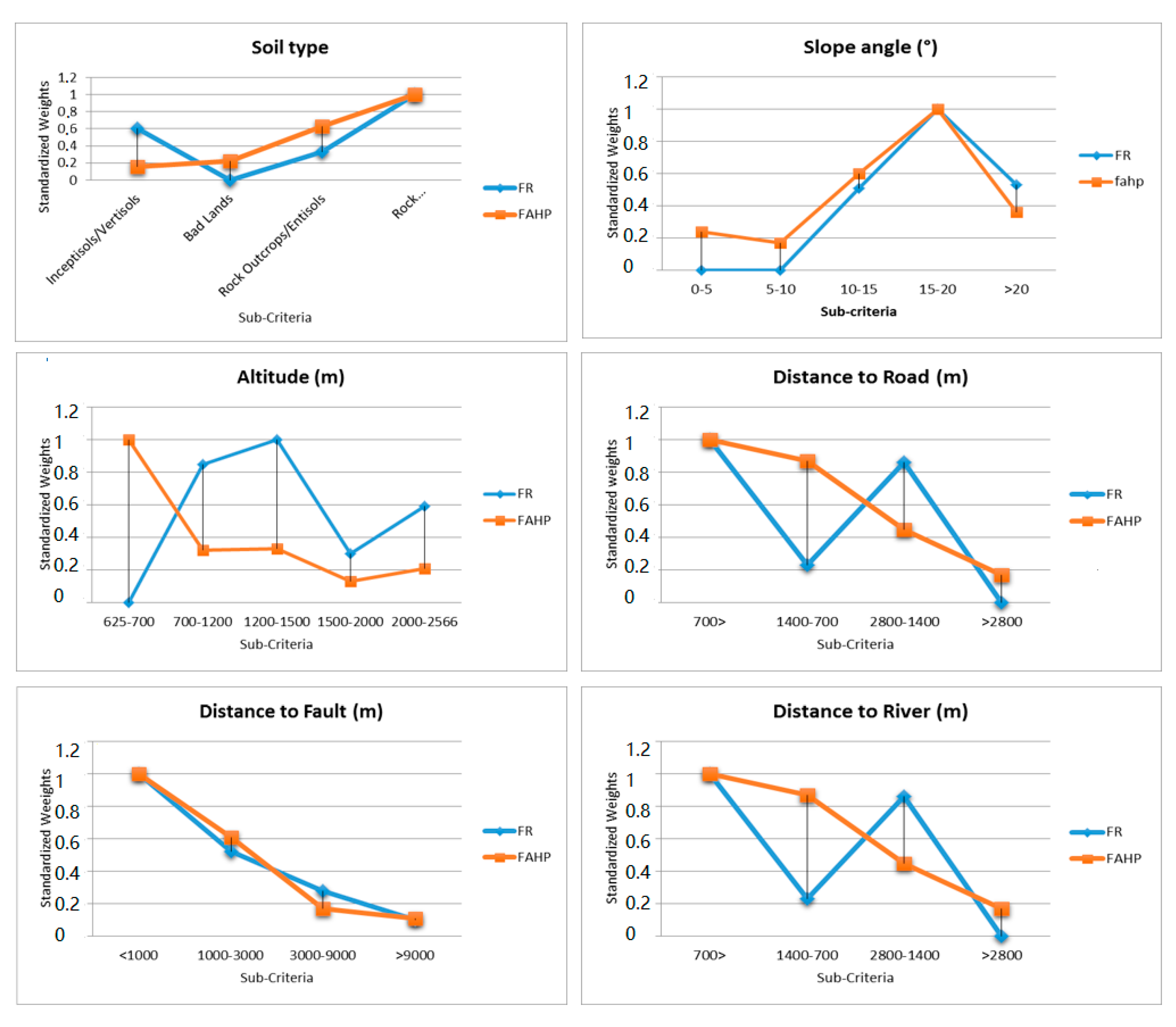
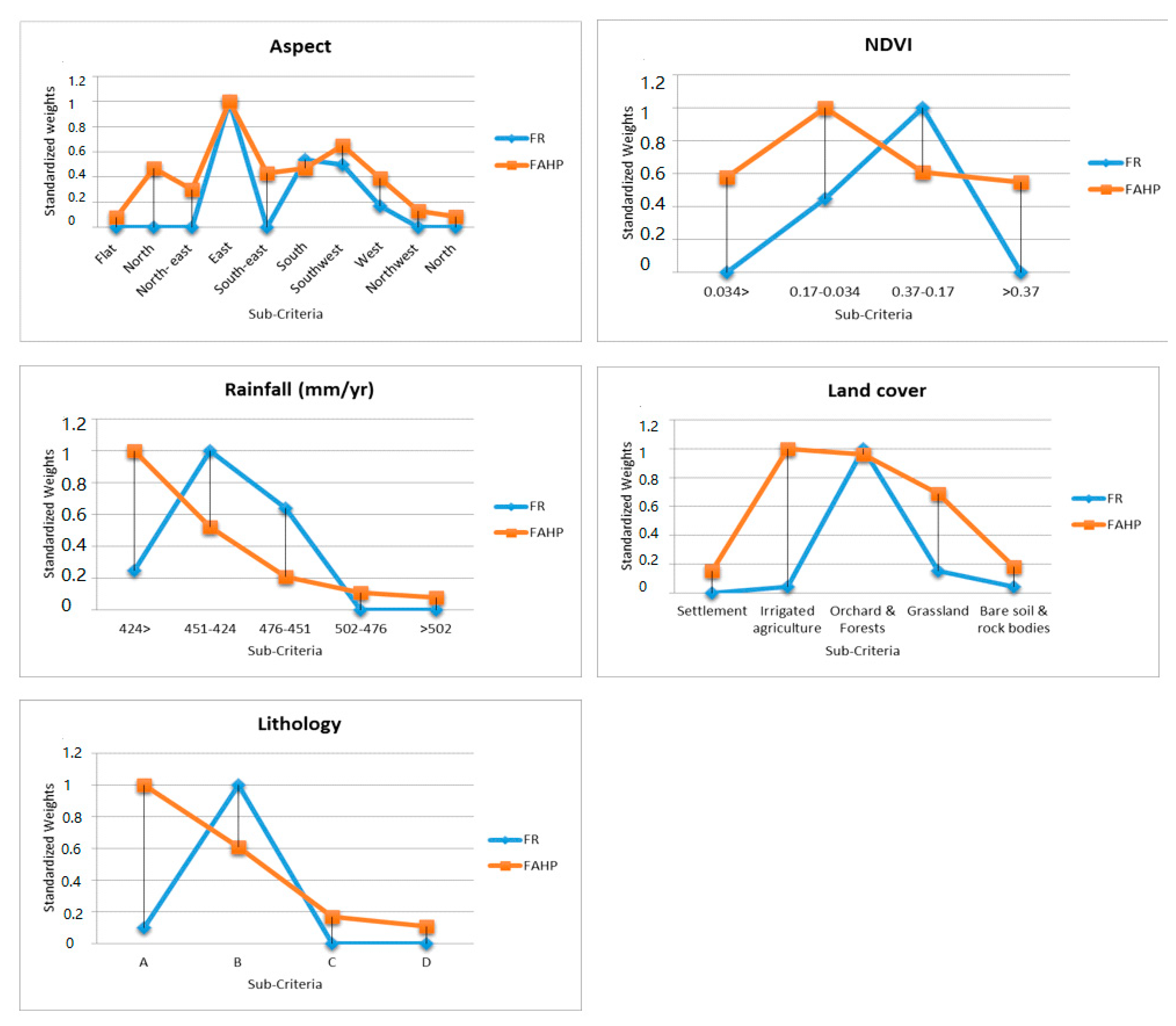
| Conditioning Factors | Classes | Percentage of Domain (%) | Percentage of Landslide (%) | FR | Normalised FR | FAHP | Normalised FAHP |
|---|---|---|---|---|---|---|---|
| Slope angle (°) | 0–5 | 32.04 | 0 | 0 | 0 | 0.1 | 0.24 |
| 5–10 | 21.31 | 0 | 0 | 0 | 0.07 | 0.17 | |
| 10–15 | 14.39 | 25 | 1.73 | 0.51 | 0.25 | 0.6 | |
| 15–20 | 11.26 | 37.5 | 3.33 | 1 | 0.41 | 1 | |
| 20< | 20.97 | 37.5 | 1.78 | 0.53 | 0.15 | 0.36 | |
| Altitude (m) | 625–700 | 34.87 | 0 | 0 | 0 | 0.9 | 1 |
| 700–1200 | 19.77 | 37.5 | 1.89 | 0.85 | 0.29 | 0.32 | |
| 1200–1500 | 17.01 | 37.5 | 2.2 | 1 | 0.3 | 0.33 | |
| 1500–2000 | 18.71 | 12.5 | 0.66 | 0.3 | 0.12 | 0.13 | |
| 2000–2566 | 9.6 | 12.5 | 1.3 | 0.59 | 0.19 | 0.21 | |
| Distance to faults (m) | <1000 | 7.96 | 25 | 3.14 | 1 | 0.52 | 1 |
| 1000–3000 | 15.06 | 25 | 1.66 | 0.52 | 0.32 | 0.61 | |
| 3000–9000 | 40.93 | 37.5 | 0.91 | 0.28 | 0.09 | 0.17 | |
| 9000 | 36.02 | 12.5 | 0.34 | 0.1 | 0.06 | 0.11 | |
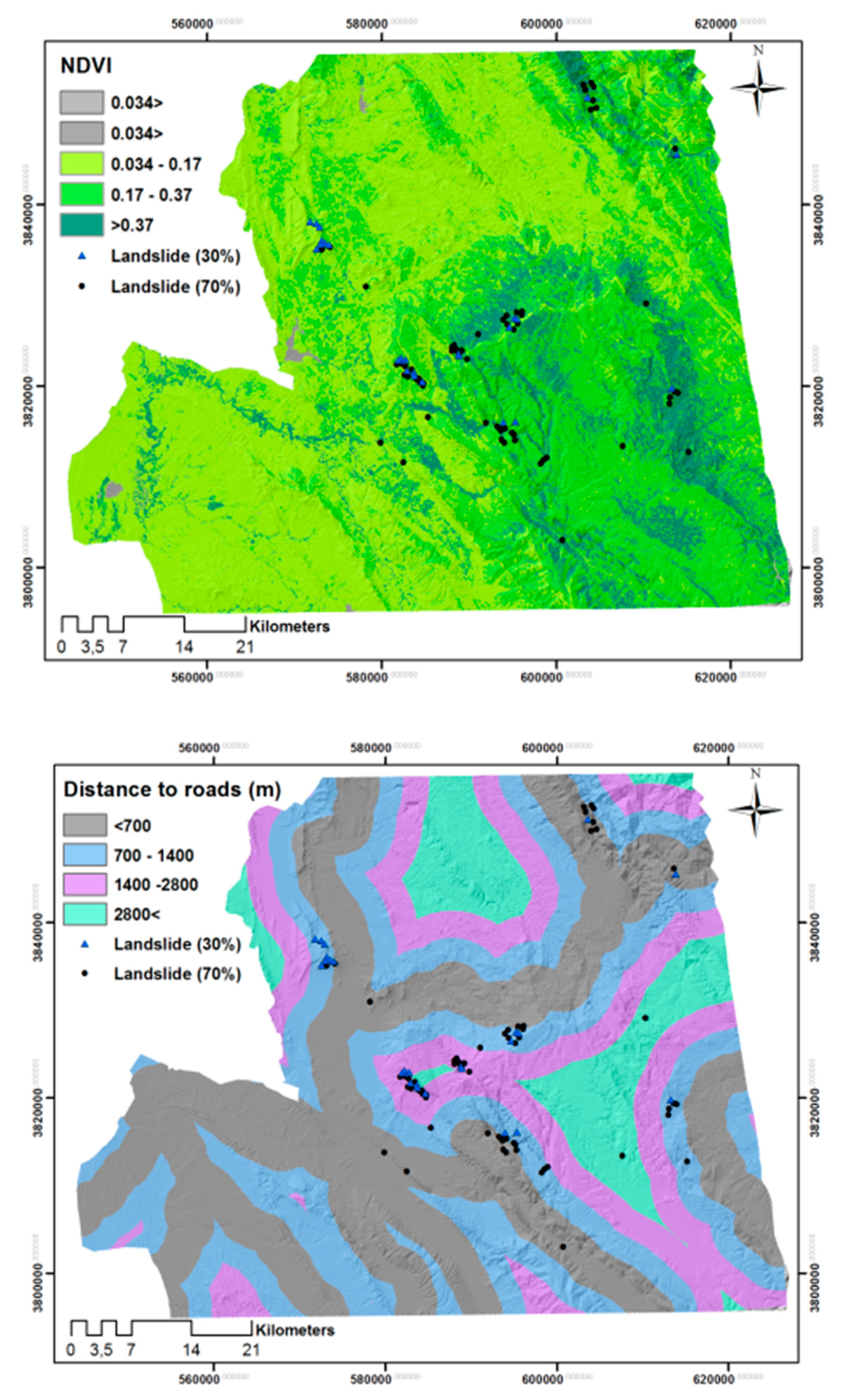
| Distance to roads (m) | <700 | 52.6 | 62.5 | 1.88 | 1 | 0.4 | 1 |
| 1400–700 | 28.27 | 12.5 | 0.44 | 0.23 | 0.35 | 0.87 | |
| 2800–1400 | 15.28 | 25 | 1.63 | 0.86 | 0.18 | 0.45 | |
| 2800< | 3.86 | 0 | 0 | 0 | 0.07 | 0.17 | |
| Distance to rivers (m) | <700 | 40.12 | 37.5 | 0.93 | 0.28 | 0.64 | 1 |
| 700–1400 | 31.9 | 12.5 | 0.39 | 0.12 | 0.21 | 0.32 | |
| 1400–2800 | 20.21 | 25 | 1.23 | 0.38 | 0.09 | 0.14 | |
| >2800 | 7.75 | 25 | 3.22 | 1 | 0.05 | 0.078 | |
| Rainfall (mm/yr) | 424 > | 45.98 | 37.5 | 0.81 | 0.25 | 0.33 | 1 |
| 451–424 | 11.92 | 37.5 | 3.14 | 1 | 0.29 | 0.52 | |
| 476–451 | 12.38 | 25 | 2.01 | 0.64 | 0.23 | 0.21 | |
| 502–476 | 10.92 | 0 | 0 | 0 | 0.08 | 0.11 | |
| >502 | 18.8 | 0 | 0 | 0 | 0.06 | 0.078 | |
| NDVI | 0.034 > | 0.23 | 0 | 0 | 0 | 0.21 | 0.58 |
| 0.17–0.034 | 77.99 | 62.5 | 0.8 | 0.45 | 0.36 | 1 | |
| 0.37–0.17 | 21.43 | 37.5 | 1.74 | 1 | 0.22 | 0.61 | |
| >0.37 | 0.35 | 0 | 0 | 0 | 0.2 | 0.55 | |
| Lithology | Group (A) | 48.21 | 12.5 | 0.26 | 0.1 | 0.52 | 1 |
| Group (B) | 36.39 | 87.5 | 2.4 | 1 | 0.32 | 0.61 | |
| Group (C) | 0.55 | 0 | 0 | 0 | 0.09 | 0.17 | |
| Group (D) | 14.38 | 0 | 0 | 0 | 0.06 | 0.11 | |
| Aspect | Flat | 18.46 | 0 | 0 | 0 | 0.02 | 0.08 |
| North | 6.37 | 0 | 0 | 0 | 0.11 | 0.47 | |
| Northeast | 10.61 | 0 | 0 | 0 | 0.07 | 0.3 | |
| East | 5.42 | 25 | 4.61 | 1 | 0.23 | 1 | |
| Southeast | 5.25 | 0 | 0 | 0 | 0.1 | 0.43 | |
| South | 14.78 | 37.5 | 2.53 | 0.54 | 0.11 | 0.47 | |
| Southwest | 10.68 | 25 | 2.34 | 0.5 | 0.15 | 0.65 | |
| West | 15.46 | 12.5 | 0.8 | 0.17 | 0.09 | 0.39 | |
| Northwest | 7.27 | 0 | 0 | 0 | 0.03 | 0.13 | |
| North | 5.64 | 0 | 0 | 0 | 0.02 | 0.086 | |
| Land cover | Settlement | 0.17 | 0 | 0 | 0 | 0.05 | 0.15 |
| Irrigated agriculture | 24.45 | 12.5 | 0.49 | 0.04 | 0.33 | 1 | |
| Orchard and Forests | 2.15 | 25 | 11.62 | 1 | 0.32 | 0.96 | |
| Grassland | 21.17 | 37.5 | 1.77 | 0.15 | 0.23 | 0.69 | |
| Bare soil and rock bodies | 51.5 | 25 | 0.48 | 0.04 | 0.06 | 0.18 | |
| Soil type | Inceptisols/Vertisols | 20.71 | 50 | 2.41 | 0.6 | 0.08 | 0.16 |
| Bad Lands | 60.64 | 0 | 0 | 0 | 0.11 | 0.22 | |
| Rock Outcrops/Entisols | 9.23 | 12.5 | 1.35 | 0.33 | 0.31 | 0.63 | |
| Rock | 9.4 | 37.5 | 3.98 | 1 | 0.49 | 1 |
| Landslide Intensity Zone/Class | Percent of Study Area | No. of Settlements | Landslide GPS Points | ||||||
|---|---|---|---|---|---|---|---|---|---|
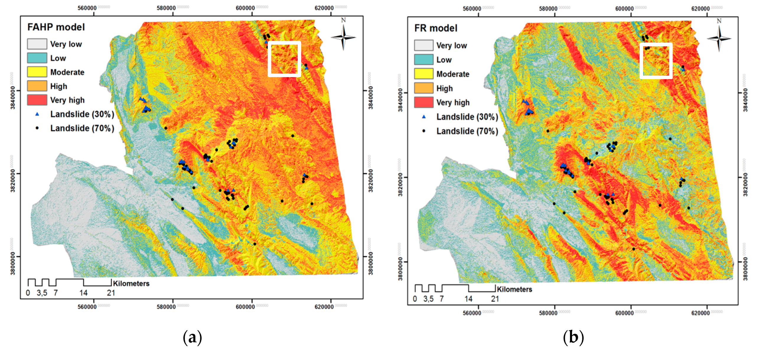
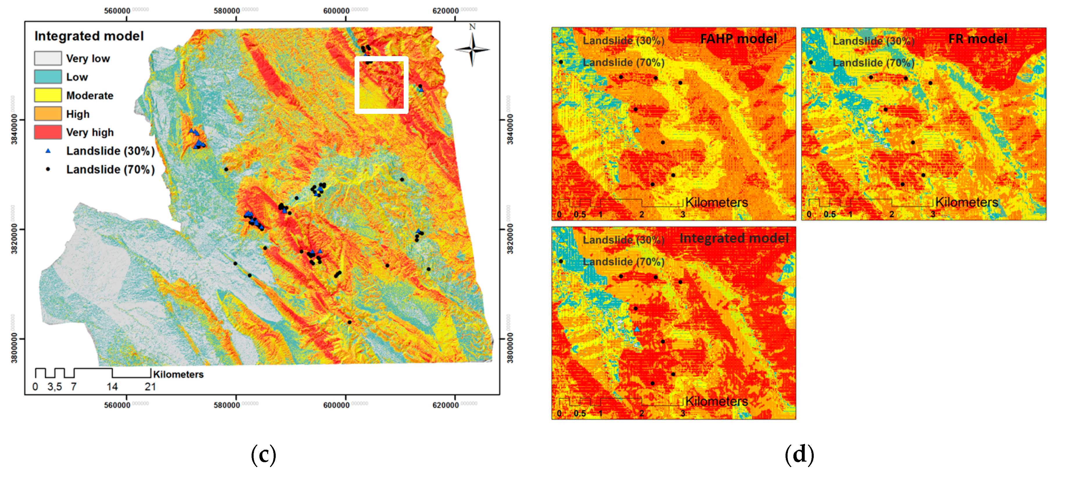
| FR | FAHP | FR-FAHP | FR | FAHP | FR-FAHP | FR | FAHP | FR-FAHP | |
| Very high | 10.24 | 10.18 | 10.7 | 40 | 42 | 50 | 9 | 11 | 24 |
| High | 19.91 | 22.08 | 19.79 | 77 | 70 | 78 | 22 | 18 | 9 |
| Medium | 29.37 | 26.33 | 24.94 | 138 | 122 | 100 | 24 | 25 | 19 |
| Low | 2584 | 19.47 | 24.17 | 127 | 92 | 107 | 8 | 10 | 9 |
| Very low | 14.61 | 22.1 | 20.38 | 88 | 150 | 141 | 1 | 0 | 3 |
© 2020 by the authors. Licensee MDPI, Basel, Switzerland. This article is an open access article distributed under the terms and conditions of the Creative Commons Attribution (CC BY) license (http://creativecommons.org/licenses/by/4.0/).
Share and Cite
Ghorbanzadeh, O.; Didehban, K.; Rasouli, H.; Kamran, K.V.; Feizizadeh, B.; Blaschke, T. An Application of Sentinel-1, Sentinel-2, and GNSS Data for Landslide Susceptibility Mapping. ISPRS Int. J. Geo-Inf. 2020, 9, 561. https://doi.org/10.3390/ijgi9100561
Ghorbanzadeh O, Didehban K, Rasouli H, Kamran KV, Feizizadeh B, Blaschke T. An Application of Sentinel-1, Sentinel-2, and GNSS Data for Landslide Susceptibility Mapping. ISPRS International Journal of Geo-Information. 2020; 9(10):561. https://doi.org/10.3390/ijgi9100561
Chicago/Turabian StyleGhorbanzadeh, Omid, Khalil Didehban, Hamid Rasouli, Khalil Valizadeh Kamran, Bakhtiar Feizizadeh, and Thomas Blaschke. 2020. "An Application of Sentinel-1, Sentinel-2, and GNSS Data for Landslide Susceptibility Mapping" ISPRS International Journal of Geo-Information 9, no. 10: 561. https://doi.org/10.3390/ijgi9100561
APA StyleGhorbanzadeh, O., Didehban, K., Rasouli, H., Kamran, K. V., Feizizadeh, B., & Blaschke, T. (2020). An Application of Sentinel-1, Sentinel-2, and GNSS Data for Landslide Susceptibility Mapping. ISPRS International Journal of Geo-Information, 9(10), 561. https://doi.org/10.3390/ijgi9100561