Groundwater Discharge in the Arctic: A Review of Studies and Implications for Biogeochemistry


Natural and Applied Sciences, Lynn University, Boca Raton, FL 33431, USA
Hydrology 2017, 4(3), 41; https://doi.org/10.3390/hydrology4030041
Submission received: 14 July 2017
/
Revised: 14 August 2017
/
Accepted: 17 August 2017
/
Published: 21 August 2017
Abstract
:Groundwater discharge, including submarine groundwater discharge, discharge to lakes and rivers, and subglacial discharge, affects freshwater and marine ecosystems across the globe. The implications for biogeochemistry include the transport of nutrients, metals, and gases to these systems. The Arctic is one region of the globe that has been understudied with respect to groundwater discharge until recently, when a handful of studies sought to understand the nature of groundwater discharge and its impacts on aquatic ecosystems. Those studies are summarized here, and the implications for biogeochemistry are synthesized. Carbon and nitrogen are the most frequently studied solutes with respect to groundwater discharge in the Arctic. The transport of carbon and nitrogen through groundwater discharge are discussed across study sites, and scientists expect their transport through this mechanism to significantly change with the onset of climate change. The Arctic is of special interest in terms of groundwater discharge, as climate change data predicts that it will warm faster than other environments. Lastly, the effects of climate change on the physical and biogeochemical aspects of groundwater discharge in the Arctic are discussed, as are research priorities.
1. Introduction
Groundwater discharge significantly impacts environments spanning the globe, influencing lake, river, and oceanic ecosystems in a significant manner [1,2,3,4]. In inland (terrestrial) environments, discharging groundwater is typically fresh and driven by hydraulic gradients (Figure 1) in aquifers [5,6]. However, the discharge of saline water to fresh surface water systems also occurs [7]. In marine environments, the process of discharging water is often referred to as submarine groundwater discharge, as it is subject to different influences than strictly freshwater systems [4,8]. These influences include wave and tidal pumping that force seawater into the coastal aquifer (Figure 1), which then discharges when the tide/wave recedes [8,9]. Buoyancy-driven flow also influences submarine groundwater discharge in the marine environment (Figure 1), but this is often a minor component of the factors driving discharge [10]. Thus, submarine groundwater discharge can include freshwater, seawater that has circulated through the coastal aquifer, or a mixture of both [8].
Inspiration for most studies of groundwater discharge came from the need to constrain solute fluxes to the ocean or surface water system. Biologically reactive solutes such as nitrogen, phosphorus, organic carbon, dissolved inorganic carbon (DIC), and trace metals such as iron (Fe) and copper (Cu) are often studied due to their influence on aquatic algae [4,8,11]. Studies on the impacts of these solutes transported by groundwater discharge found that it can spur growth in harmful algae and influence the location of oyster beds [12,13]. More recently, groundwater discharge was identified as a source of the pollutants and the pollutant-indicators mercury (Hg), caffeine, and fecal indicator bacteria, to ocean ecosystems [14,15,16,17]. Conversely, groundwater discharge can improve surficial water quality as well [18]. Lastly, groundwater discharge can be a source of the greenhouse gas methane (CH4) for terrestrial and marine environments [9,19,20].
Many methods exist to quantify and detect groundwater discharge. The most common methods include calculating a box model of radium (223Ra, 224Ra, 226Ra, 228Ra, half-lives of 11.4 days, 3.6 days, 1600 years, and 5.8 years, respectively) and radon (222Rn, half-life 3.8 days); these solutes are typically rich in groundwater due to close rock–water interactions and cation exchange, and low or negligible in coastal waters due to radioactive decay [4,21,22,23]. Radon can be measured continuously on site with a Rad-7 from Durridge, whereas the measurement of radium requires filtering large quantities of water on a manganese (Mn) filter and measuring the radioactive decay on a Radium Delayed Coincidence Counter (RaDeCC) or via gamma spectroscopy [22,24]. As radon is an inert gas, it gives good estimates of fresh groundwater discharge in both terrestrial and marine environments, except for areas where gas exchange is quick or difficult to quantify [4]. Calculating groundwater discharge with radon requires knowledge of wind speed, which can be measured either by the researcher or a local weather station [22,25]. This requirement for radon presents a problem in remote locations. Conversely, radium is best used only in brackish and saline environments, as salt in the water is required to strip radium from the aquifer material via cation exchange [4,26]. As some of the radium isotopes have short half-lives, they must be measured within days of collection to ensure low error, which again presents an obstacle at study sites distant from the RaDeCC location. Additionally, calculating groundwater discharge using radium requires knowledge of the water residence time, which can be difficult to ascertain and thus a potentially large source of error in the calculation [27]. Another method of measuring groundwater discharge is seepage meters, which require simple and inexpensive equipment compared to tracers. However, they can be cumbersome in poor weather, deep water, areas of rocky bottom, or with large waves [6,28]. In lakes, where the inflow and outflow of all of the other sources of water are measured, and precipitation and evaporation can be calculated, implementing a water budget is possible [4,29]. With the advent of satellite imaging and remote sensing, detecting plumes of groundwater by their temperature difference from surrounding water is a new option [30]. This technique, while efficient at identifying groundwater hot spots, cannot yet be used to calculate discharge [30]. Advection-diffusion and heat flow modeling are also utilized to calculate groundwater discharge, but much less often than the most popular method of using tracers [4,10].
The scales of studies of groundwater discharge vary greatly. Most studies focus on determining the magnitude of discharge and associated solute fluxes for a particular section of beach, bay, or lake [1,3,4]. Several hundred studies were published with this goal in mind. The intensive study of a small section of coastal aquifer, and the influence of hydraulic gradient, mixing, and tidal/wave pumping, can result in several studies that fully describe the biogeochemistry of an aquifer and implications for groundwater discharge [4,8,11]. Waquoit Bay, Massachusetts, is one such site of intensive study [31,32,33]. In contrast, large-scale studies seek to quantify discharge to an entire ocean basin, while the scientific community moves towards creating a global model of groundwater discharge to the ocean [23,34,35]. Most of these large-scale studies focus on the Northern Atlantic basin, and other easily accessible ocean basins [23,35]. Even the most extensive study in terms of scale neglected the Arctic Ocean in its calculations [34]. Herein lies the issue addressed in this paper. Despite the size of the Arctic Circle (~30 million km2), only a limited number of studies have been conducted on both fresh (terrestrial) and marine groundwater discharge, and most of these were published in the preceding decade. This paper will review several of those studies, synthesize their results, investigate gaps in research, and predict how the changing Arctic will affect groundwater discharge.
The Arctic Circle is unique when considering groundwater discharge. The terrestrial areas of the circle are generally underlain by continuous permafrost (permanently frozen ground), which has implications not only for groundwater flow, but solute composition as well [36]. Permafrost can act as a barrier to groundwater flow, or limit groundwater flow in the active layer (the topmost layer that thaws seasonally) above the permafrost during warmer months [37]. Permafrost may also act a source of water and solutes to groundwater in the active layer as it thaws, a process that is progressing as the Arctic climate warms [36]. Indeed, a permafrost thaw of 1–4 °C was observed in the preceding decades on the Alaskan North Slope [38,39]. The Arctic Ocean collects 11% of the global river discharge, and groundwater was shown to rival river discharge in the Atlantic Ocean basin [23,40]. If this ratio of groundwater to river water discharge is similar in the Arctic, this means that groundwater may play an important role in terrigenous water and solute delivery to the Arctic Ocean.
2. Studies in the Arctic
A total of 16 peer-reviewed studies concerning groundwater discharge in the Artic are reviewed here, most of them published in the previous 10 years. Several of the studies overlap in location (Table 1), and most of them had a study site in North America (Figure 2). Of the 11 sites studied, six were terrestrial (fresh water) in nature and the remaining five were marine, which is also how the next section of text is separated.
2.1. Terrestrial Sites
The most studied terrestrial system in the Arctic with respect to groundwater discharge was Toolik Lake (1 on Figure 2), largely due to the Long Term Ecological Research Station (LTER) that provides scientific support, and its accessibility by truck via the Dalton Highway, an eight-hour drive north of Fairbanks. Toolik Lake is a kettle lake on the tundra of the North Slope of Alaska and is approximately 1.5 km2 in surface area. The first study of groundwater discharge of this lake appeared in 1985 in a research article by Whalen and Cornwell [29], which sought to describe nutrient cycling within the lake. Groundwater discharge to the lake was only quantified due to an unaccounted source of water in a water budget conducted at the lake [29]. Therefore, although the study of groundwater discharge was not the explicit purpose of this study, it was the first to identify groundwater discharge and create a standard against which future studies could be compared.
Toolik Lake again became the focus of studies regarding groundwater discharge more recently, when a slew of studies were published that sought to characterize the importance of groundwater discharge to lake methane balance [20,41,42]. Dimova et al. [41] characterized groundwater flow through the tundra and discharge to the lake using a box model based on the radon isotope content of the lake and surrounding saturated active layer and resistivity measurements of the tundra, from which changes in temperature with depth could be assessed. Paytan et al. [20] computed the flux of methane to Toolik Lake using box models based on radium and radon isotopes paired with methane concentrations in groundwater from the active layer. Lecher et al. [42] compared the flux of methane to the lake through groundwater discharge to that of diffusion from lake bottom sediments; their study determined the governing processes of methane concentrations in groundwater surrounding the lake with a mixing model of methane in the lake based on carbon (C) and hydrogen (H) isotopes in methane from the lake, active layer groundwater, and bottom sediments. Cumulatively, these studies found that groundwater discharge is a significant source of methane to the lake, providing up to 70% of total methane inputs. Groundwater enters the lake at the shoreline, where the lake to air flux of methane is also the highest, and methane in groundwater is created via the bacterial methyl-type fermentation pathway [20,41,42]. A scaling analysis of the fluxes across all Arctic lakes showed that the flux of methane from groundwater to the atmosphere through lakes could be a significant source of methane to the atmosphere across the Arctic, but more investigation of this mechanism is required across other Arctic lakes, as the fluxes were only derived from Toolik Lake [20]. This is especially true as Toolik Lake is a kettle lake (a type of lake formed by glacial processes and relatively deep compared to its surface area), and therein has different biogeochemical dynamics than the abundant thermokarst lakes (which are formed by permafrost thaw processes and relatively shallow compared to their surface areas) of the Arctic [36].
Another study of groundwater discharge to an Arctic lake was conducted at Shellabear Lake on Melville Island in the Canadian Arctic (2 on Figure 2), which was also the highest latitude terrestrial study at 74°50′ N [43]. Shellabear Lake is a hypersaline lake that is seasonally isolated and approximately half the size of Toolik Lake at 0.59 km2 [43]. Here, Dugan et al. [43] sought to field test using radon as a tracer of groundwater discharge in an extremely remote Arctic lake. They found that radon concentrations in the lake increased with the onset of snowmelt, implying that groundwater discharge to the lake increased at that time [43]. Furthermore, like Toolik Lake, groundwater mostly enters the lake from the perimeter. However, flux from the bottom of the lake through the thaw bulb (Figure 1) below it is a possibility as well [43]. Although groundwater discharge was not calculated at this site, as only radon concentrations were measured in the lake, it does show the possibility of conducting such tracer studies in remote areas of the Arctic.
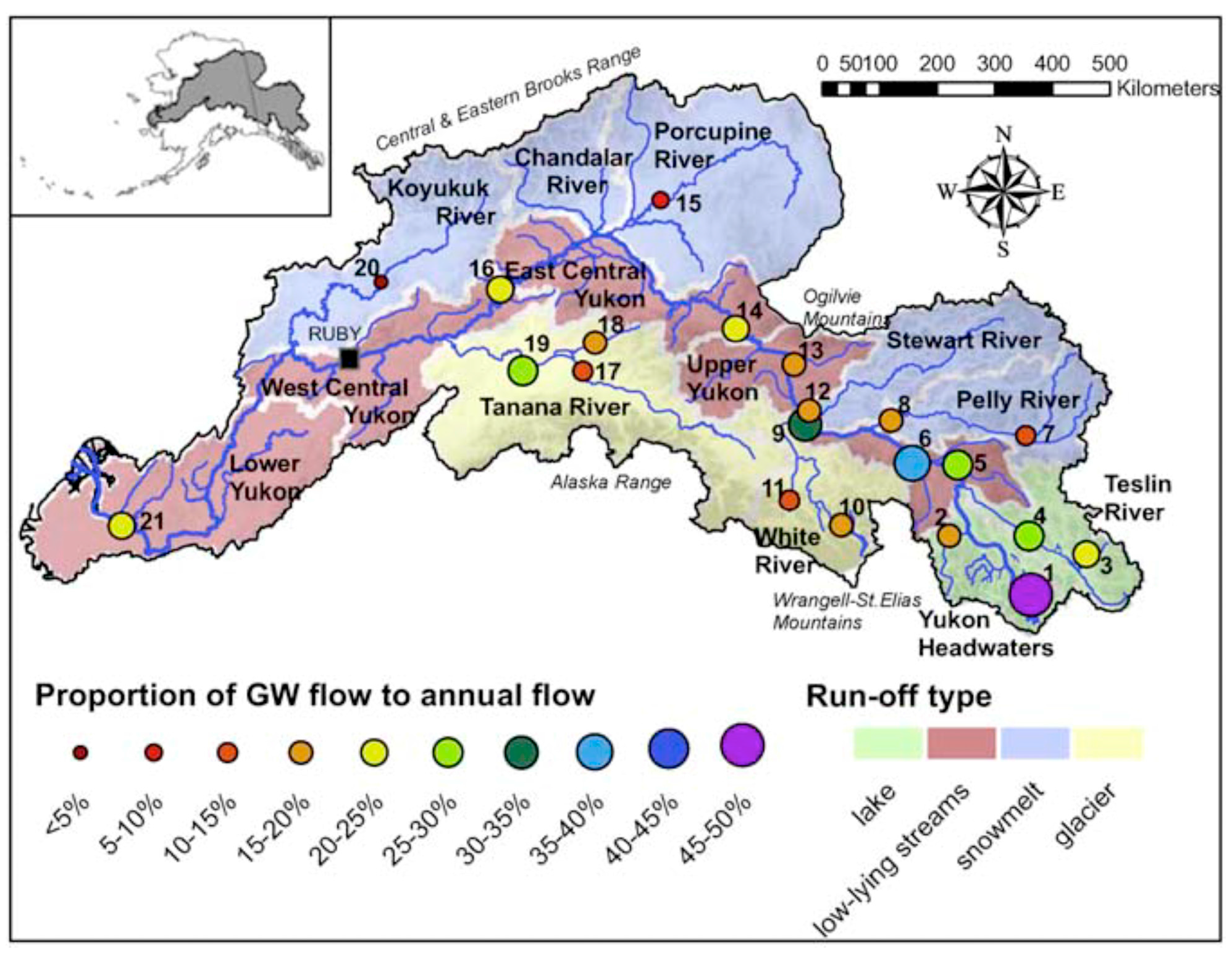
Terrestrial studies of groundwater discharge in the Arctic are not limited to lakes. The largest scale of the terrestrial study conducted by Walvoord and Striegl [2] encompassed the entire watershed (853,300 km2) of the Yukon River (3 on Figure 2) in both Alaska and Canada. In this study, the authors utilized a water budget computed from the differences in winter and summer flow collected from stream gauges to compute the percent of water in the rivers within the watershed sourced from groundwater (Figure 3) [2]. Utilizing over 30 years of data, they found the contribution of groundwater discharge to rivers increased significantly in most rivers as time progressed, even though annual river flow remained the same [2]. This increase was attributed to warmer Arctic summer temperatures, which thawed permafrost and increased the active layer [2]. If these trends are representative of most of the Arctic, they imply a shift to a more groundwater-dominated system across the Arctic in the future, a prediction reflective of other studies [36,52,53]. Combining their data with previously reported data on nutrients in the Yukon River basin, Walvoord and Striegl [2] predicted that dissolved organic carbon and nitrogen (DOC and DON) export will decrease, and dissolved inorganic carbon and nitrogen (DIC and DIN) export will increase. These biogeochemical changes have implications for the Bering Sea, as the Yukon eventually drains to it.
The final terrestrial environment where groundwater discharge has been measured is in glacial environments. There are two types of subglacial flow: channelized and distributed system flow [54,55,56]. Channelized flow is the faster of the two types, and consists of melt water and precipitation traveling beneath the glacier through crevices, caverns, and other openings [54,55,56]. Distributed system flow is the slower type of flow, and is a type of groundwater that flows through the subglacial till and sediments at the glacier bed [54,55,56]. Distributed system flow is thought to occur through the first few meters of sediment beneath the glacier, but can vary glacier to glacier. Although deeper groundwater flow can occur beneath glaciers, distributed system flow was the focus of the studies reviewed here.
An early study of Werenskiold Glacier (4 on Figure 2) by Kies et al. [44] explored the applicability of pairing measurements of radon with electrical conductivity to describe the pathways of subglacial meltwater at discharge sites at the glacier’s terminus [44]. Discrete samples of electrical conductivity and radon were measured in water at the outflow at various times and compared. The results of this study showed that water at the discharge site was high in radon, and its electrical conductivity was indicative of water in close interaction with the subglacial till, even flowing through the till as distributed system flow (groundwater) [44]. Conversely, water low in radon and electrical conductivity at the discharge sites was more representative of water that transited through the subglacial environment in channels [44]. Water with intermediate levels of these parameters, or a mix of high and low, was indicative of a mix of the distributed system and channelized flow or other processes [44]. As this study used only discrete samples, distributed system discharge could not be quantified. At a subarctic site in Alaska, the electrical conductivity of glacial outflow was also used to explore the relationship between distributed system flow and glacier movement, which shows the value of electrical conductivity in exploring multiple aspects of subglacial distributed system flow [57].
The first studies to translate measurements of radon and other tracers to measurements of distributed system flow at a glacial outflow and in a proglacial river occurred at two glaciers in Greenland, Leverette and ‘N’ Glacier (5 and 6 on Figure 2 respectively) [45,46]. At ‘N’ Glacier, Bhatia et al. [46] used a mixing model of radon and stable isotopes in water (oxygen-18 and deuterium) to determine the contribution of distributed system flow to water at the outflow. Although the sampling was discrete, they were able to determine that distributed system flow comprised 3.4–26% of water discharging at the glacial outflow throughout the May to July field season [46]. At Leverette Glacier, Linhoff et al. [45] modified an analytical radon model used to calculate groundwater discharge to a river to calculate the contribution of distributed system flow through the subglacial till to the proglacial river, which they estimated to be 1–5% of river flow. Furthermore, this contribution increased drastically after the occurrence of large surface melt events, and the amount of water in the distributed system influenced movement of the glacier [45]. They were able to make the advancement of quantifying distributed system discharge by collecting continuous measurements of radon concentrations at the outflow [45].
Cumulatively, these glacial studies show that groundwater flow occurs below glaciers in the form of distributed system flow and can contribute a substantial amount of water at the outflow. Furthermore, the close rock–water interaction of water below the glacier affects the geochemical content (specifically radon, water isotopes, and conductivity) of water at the outflow, and these geochemical characteristics change throughout the thaw season. Although, the solutes studied so far have not been biologically reactive, other studies have shown ice sheets and glaciers are a source of iron to the ocean, which may be especially important, as many areas of the ocean are iron limited [58,59]. Additionally, a subarctic study in Iowa found that glaciers also increase recharge of confined aquifers, further exploring how glaciers affect groundwater systems [60].
2.2. Marine Sites
Some of the studies at marine sites focused on groundwater discharging from the active layer above the permafrost, and other studies evaluated discharge from the unfrozen aquifer below the permafrost (subpermafrost groundwater). The most studied location with respect to flow through the active layer was Barrow, Alaska on the Arctic Ocean (7 on Figure 2) [9,41,47]. Barrow, Alaska sits at the intersection of the Beaufort Sea and Chukchi Sea, and is the most northern point in the United States. Lecher et al. [9] quantified submarine groundwater discharge to the Arctic Ocean at this site as 12 ± 4 m3 day−1 m of shoreline−1, and the associated methane flux to be up to 11.8 ± 3.9 mg day−1 m of shoreline−1, through using a radium isotope-based box model and methane concentration data from active layer groundwater. This study, while being the first to account for the total submarine groundwater discharge to the Arctic Ocean (fresh groundwater + recirculated groundwater), found it to be a relatively minor source of methane to the Arctic Ocean [9]. Dimova et al. [41] further characterized submarine groundwater discharge to the Arctic at this site by calculating a specific discharge of 1.0 ± 0.3 cm day−1 with a radon isotope box model and resistivity measurements of the tundra coastline, as at Toolik Lake. The studies agreed that the effect of tidal pumping on groundwater discharge at Barrow was negligible due to the low tidal range, and that submarine groundwater discharge there must be driven by other factors, such as permafrost melt [9,41]. These studies were followed later by Lecher et al. [47], which paired the submarine groundwater discharge fluxes from Lecher et al. [9] with coastal groundwater nutrient and trace metal data from the same location to determine the importance of submarine groundwater discharge as a source of these solutes to the Arctic Ocean. While this study was successful in identifying submarine groundwater discharge as a source of nitrate (NO3), silicate (SiO4), phosphate (PO4), iron (Fe), and nickel (Ni) to the Arctic Ocean, it was unable to compare these fluxes to other sources, due to lack of data and knowledge about other sources [47].
Charkin et al. also used radium and radon in addition to temperature and salinity data to characterize groundwater discharge in the Laptev Sea [48]. Cross plots of these parameters were used to identify the presence of different water types in the Laptev Sea. While Charkin et al. [48] did not quantify submarine groundwater discharge in this study, they were the first to observe additional types of submarine groundwater discharge to the Arctic Ocean. These other sources included the discharging of subpermafrost water through fault zones and brine squeezed out of ice formation zones [48]. The scales of such discharge, and hence this study site, were much larger (100 s of km) compared to the studies at Barrow, which were limited to the 1 km scale [48].
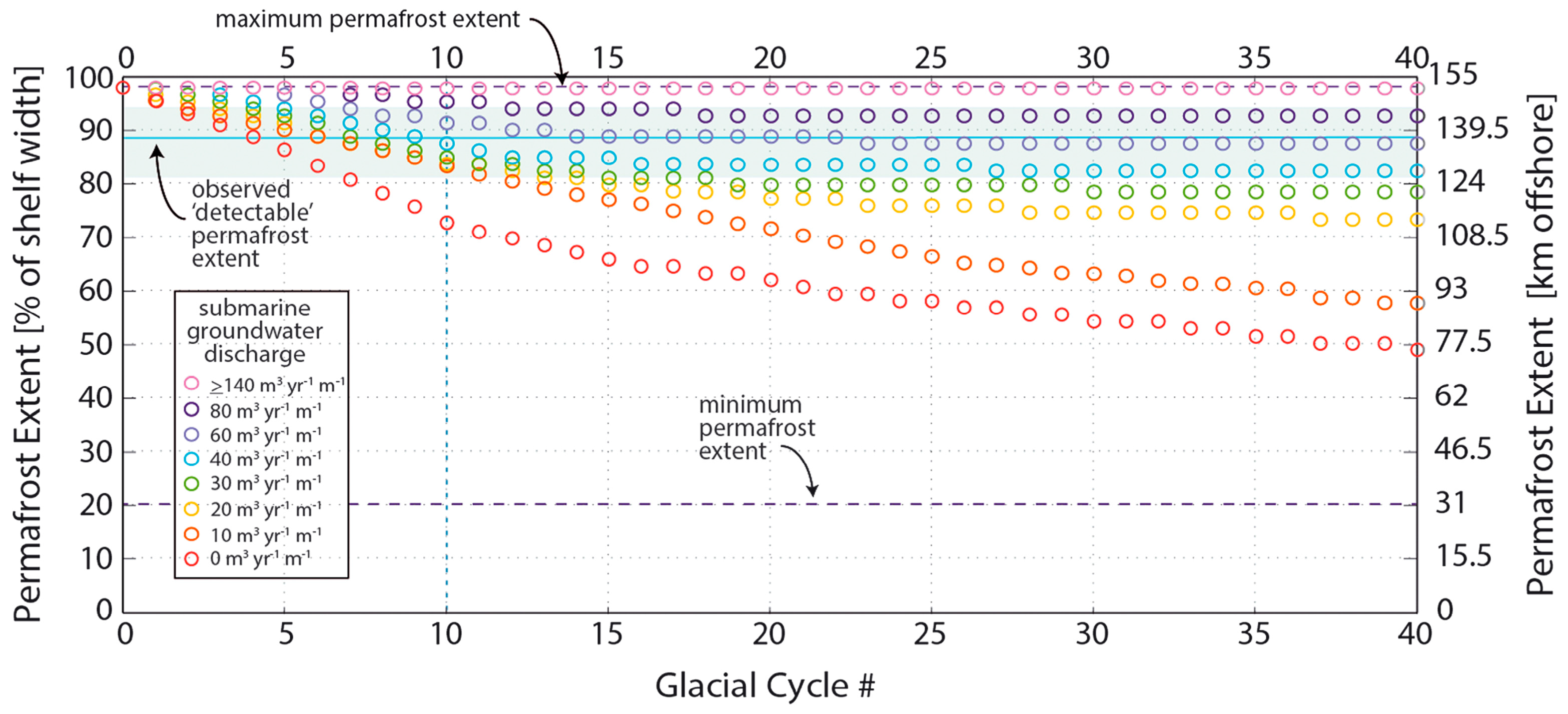
Published within the same year of the Barrow studies, and also located on the Beaufort Sea (10 in Figure 2), a paper exploring the impacts of submarine groundwater discharge on methane hydrate stability was published by Frederick and Buffett [10]. Differing from the calculations at Barrow, this study assumed the groundwater flow to be subpermafrost [10]. Many of the assumptions of this study were based on a previous study by Deming et al. [49], which determined the presence of subpermafrost groundwater flow on the North Slope of Alaska (9 in Figure 2) by heat flow modeling. While this previous study did not calculate submarine groundwater discharge itself, it did hypothesize its existence on the Alaskan and Canadian Arctic coast due to gravity-driven channelized flow through geologic units with high permeability [49].
Frederick and Buffet [10] built on this work by actually calculating submarine groundwater discharge (Figure 4) using a modification of a previously existing two-dimensional finite volume numerical model. The model was run with different quantities of submarine groundwater discharge, and the researchers compared the results of the model with observations of permafrost extent to determine what values of submarine groundwater discharge best fit the field observations [10]. The resulting flux was 60–140 m3 year−1 m of shoreline−1, and represented fresh groundwater discharge only [10]. More importantly, higher rates of submarine groundwater discharge corresponded to increased methane hydrate stability, due to the freshening of the pore fluids [10]. The last finding of this study was that submarine groundwater discharge at this site was largely buoyancy-driven, as fresh groundwater is less dense than the corresponding seawater [10]. Frederick and Buffet built upon this work with a later paper, where they explored the ability of submarine groundwater discharge to aid in methane hydrate expansion by delivering methane to the cold continental shelf sediments using a numerical model of two-phase flow of pore fluids, based on the finite volume method [50]. They found that in subpermafrost areas, groundwater flow did assist in the development of methane hydrate formation, even if the groundwater was undersaturated with respect to methane [50]. However, the results of hydrate formation were inconsistent within areas of continuous permafrost, and relied more on permafrost extent [50].
One of the first studies of submarine groundwater discharge occurred at Cambridge Fjord on Baffin Island (11 on Figure 2) [51]. This study is unique in that it quantified point source discharge of a brackish spring into the fjord, rather than diffuse seepage [51]. Remote acoustic sensing was used to identify the spring and calculate a flux of 0.14 m3 s−1 [51]. The goal of this study was to test the method of using acoustic imaging to study a submarine spring, and thus solute transport and implications for biogeochemistry were not discussed. Therein, its major contribution was to identify another mechanism by which groundwater discharges to the ocean via submarine springs.
To summarize the marine studies, they exhibit the variety of pathways through which groundwater discharge occurs on the Arctic Ocean. Flow was observed to discharge from the active layer, from under the permafrost via buoyancy driven flow, as point sources at springs, and as brine in ice formation zones. Heterogeneity of flow is common in submarine groundwater discharge studies across the globe, with some types of discharge (such as flow through volcanic channels on islands) having a much large flux than others (such as diffusive flow) [1,21]. An understanding of all these types of discharges and their associate solute flux will be important in the future, if basin-scale solute fluxes through submarine groundwater discharge are to be constrained in the Arctic Ocean.
3. Implications for Biogeochemistry
3.1. Carbon
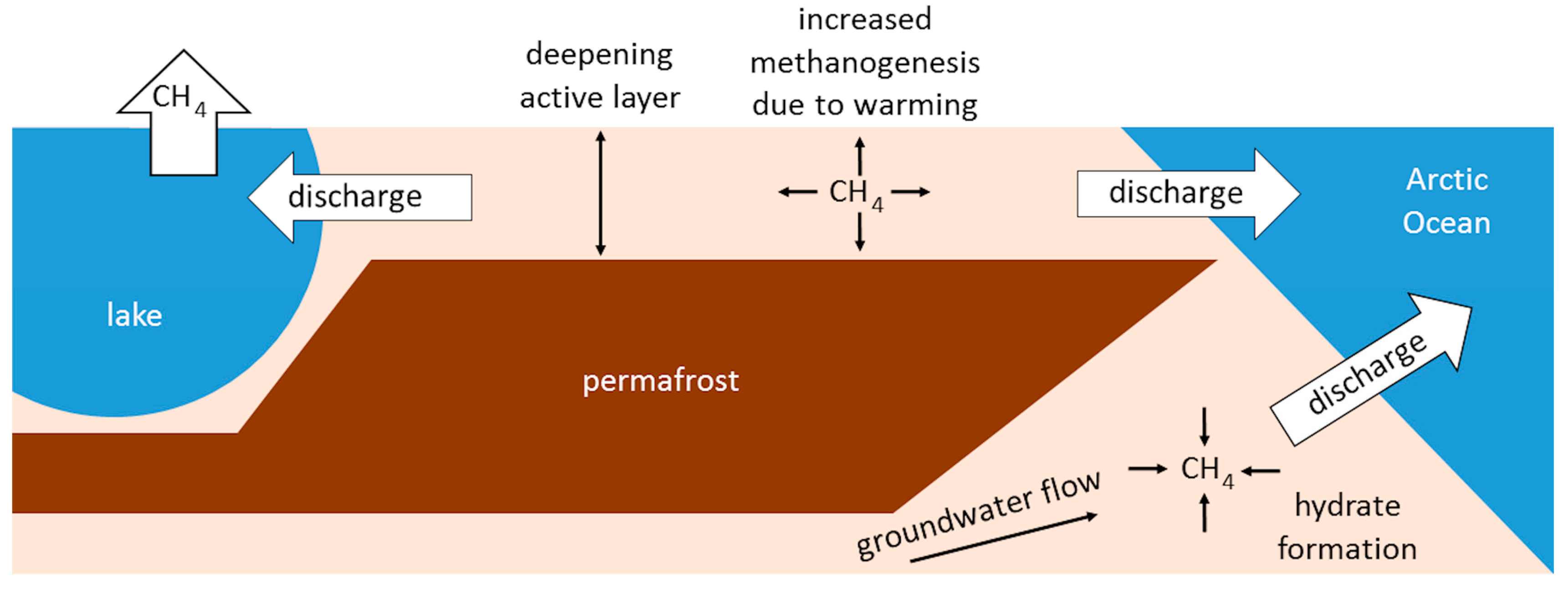
Synthesizing the data from these studies, a few trends become clear, the most robust of which is the effect of groundwater discharge on the methane cycle. These processes are displayed in Figure 5. At Toolik Lake, it was shown that groundwater discharge could transport methane from the saturated zone of the active layer to the lake, where it can more easily escape to the atmosphere [20,42,61]. This is further supported by isotopes in methane that show large contributions of groundwater to the methane inventory of near-shore areas where the lake to air methane flux is highest [42,61]. This could already be a significant source of methane to the atmosphere in the Arctic [20]. However, this mechanism of methane transport is expected to increase, as the Arctic is moving towards a more groundwater-dominated system due to increases in permafrost thawing brought on by warmer temperatures, which both deepen the active layer and contribute water to it [2,36,42,52]. Indeed, some thermokarst lakes in the Arctic have already changed in size due to more connected drainage brought on by a thicker active layer [62,63,64], including drainage to the groundwater system [37]. Warmer temperatures will also increase the rates of methanogenesis via the bacterial methyl-type fermentations pathway in the active layer [42,65].
Therefore, the findings from the terrestrial studies display a positive feedback loop whereby increased concentrations of methane in the atmosphere induce higher temperatures in the atmosphere. These higher temperatures cause permafrost thawing, which increases both groundwater flow to surface water bodies, and faster rates of methanogenesis in the active layer [2,52,65]. Cumulatively, this causes more methane transport to surface water bodies where it can escape/evade to the atmosphere, which then leads back to the start of the cycle. Changes in precipitation may also alter the groundwater system, as increases in precipitation would lead to more groundwater flow. Changes in precipitation with a warming climate are inconsistent across the Arctic; as a result, it is too early to fully assess how this part of the hydrological cycle will affect groundwater flow [66,67].
In contrast to the freshwater environments, submarine groundwater discharge may be slowing down the release of methane to the atmosphere. Not only was submarine groundwater discharge found to be a minor source of methane to the Arctic Ocean on the Alaskan coast, but on the Canadian coast, freshwater discharge was shown to increase methane hydrate stability and trap methane in hydrates before it could reach the ocean in dissolved phase [9,10,50]. Therefore, methane transport in this environment represents a stopgap in the positive feedback loop. Methane saturated or even undersaturated in groundwater precipitates out in the form of methane hydrates on the cold continental shelf system, essentially stripping the submarine groundwater discharge of methane, which would otherwise have eventually vented to the atmosphere [50]. Of course, this stopgap has a limit of effectiveness, as eventually enough warming on the shelf would destabilize the hydrates. That would, in turn, lead to the release of sequestered methane to the water column and atmosphere.
Aside from methane, the changing Arctic also has implications for the export of carbon in the form of DOC and DIC through groundwater discharge to rivers that drain to the ocean. Not only did Walvoord and Striegl [2] find that the export of DOC decreased in the Yukon River basin and its tributaries, but DOC concentrations have been found to decrease with increasing active layer thickness [68]. As soil type influences not only the rate of permafrost thaw, but also the DOC concentration in the active layer, the relationship between these three factors will evolve as the climate continues to warm [68]. However, as both these studies discuss the transport of DOC through the active layer in only Alaska, they are not representative of the entire Arctic. The opposite effect—increasing DOC export with increasing permafrost degradation—has been observed in other areas of the Arctic, which makes generalizations difficult to ascertain [32] (and references therein). It has been proposed that DOC concentrations in groundwater will decrease and DIC concentrations will increase in Arctic groundwater. This is due to thawing permafrost that will increase the depth of groundwater flows, which will pass from areas of high organic content to mineral soil [2,36]. Studies have yet to be published that fully evaluate the validity of this assertion.
3.2. Nitrogen
Nitrogen in Arctic groundwater discharge has not been studied as much as carbon, but it is still important biologically. Two mechanisms exist by which DIN can be exported from groundwater to the Arctic Ocean. Lecher et al. [47] showed submarine groundwater discharge could directly transport nitrate to the Arctic Ocean at a flux of 4.3 ± 2.1 mol day−1 m−1, and that submarine groundwater discharge is especially rich in nitrate compared to phosphate and silicate, with respect to Redfield ratios. Walvoord and Striegl [2] explored how DIN that was transported to rivers through groundwater discharge drained to the ocean, and how this mechanism has changed with thawing permafrost. They discovered that DIN export increased through this mechanism as permafrost thawed, a trend also attributed to groundwater flow moving from organic-rich soils to mineral soils, as with the DOC to DIC shift [2,36]. This DIN increase likewise corresponded with a DON decrease [2]. Observations of increased nitrate in the Kuparick River near Toolik Lake have also been attributed to increased groundwater flow and discharge to the river due to permafrost thaw, which indicates this trend is not limited to one river system [69,70,71]. Increased permafrost thaw may likewise increase the transport of DIN through submarine groundwater discharge, as studies pointed to permafrost thaw as a driver of this discharge [41].
As groundwater discharge occurs during the summer, it fills an unmet need in the Arctic Ocean, which becomes nitrogen limited in the summer [72]. In the future, increasing export of DIN to the ocean through groundwater discharge may become more important as the climate changes. N-limited periods in the Arctic Ocean are expected to lengthen as primary productivity increases in response to declining sea ice extent [73]. If DIN export through groundwater discharge in this region increases, it may ease some of the nitrogen limitation periods expected in the ocean. Such increased primary productivity would have implications for the Arctic marine food chain and carbon sequestration, although the true impact is not yet known.
3.3. Other Solutes
Other solutes found to be transported through groundwater discharge in the Arctic included silicate, phosphate, iron, and nickel [47]. However, the relative importance of groundwater discharge as a source of these solutes to surface water bodies and the ocean, both currently and in the future, has yet to be studied. Phosphate concentrations have been predicted to increase in Arctic groundwater due to more flow through mineral soils caused by a deepening active layer, but only direct measurements have yet been made in the Yukon basin to confirm this [53,74]. Likewise, silica, nickel, iron, and major ion export should increase as mineral weathering and increased groundwater flow occurs, but measurements of these fluxes are lacking [36,74]. Currently, only circumstantial evidence in the form of increased concentrations of these solutes in surface waters exists to support these ideas [36,53].
4. Research Priorities
Building on current research, there is a need to quantify the fluxes of solutes through groundwater discharge to surface waters and the ocean in the Arctic, collect evidence to assess whether predicted changes of these fluxes are actually occurring, and compare these fluxes to other sources of these solutes. The implications of bioactive nutrient transport to the Arctic Ocean, such as increased primary productivity due to DIN transport, should be ascertained to determine if groundwater discharge is now—or will be in the future—an important source of nutrients to that water body. Furthermore, almost all of the studies of Arctic groundwater discharge acting as a conduit for solutes have been limited to North America. Observations of the processes from other areas of the Arctic should be attempted before generalizations about how groundwater discharge will affect biogeochemistry in a changing Arctic can be made. Lastly, although subglacial groundwater flow has been identified as a potential source of solutes to proglacial rivers, and therefore the ocean, the fluxes of solutes through this discharge have not yet been quantified [45]. Glacial watersheds have been shown to be poor in DIN, and changes in subglacial flow from channelized to distributed system flow will have repercussions for the solute content of proglacial and downstream systems [75]. Furthermore, as ice sheets and glaciers contribute iron to the ocean, further study of how distributed system flow contributes to the flux of iron is warranted [59,60]. As a warming climate is expected to increase glacial melt, subglacial flow, and distributed system flow, new research that explores the nuances of these processes and how climate will affect them would also be of value.
There are also new avenues of research that should be explored. No research has presently been conducted on the influence of Arctic islands on groundwater discharge in the Arctic. With extensive archipelago systems, Arctic islands may represent a disproportionate amount of groundwater discharge to the Arctic Ocean due to their large coastline-to-area ratio, as has been shown of islands in the Pacific [76], (and references therein). A research study that specifically addresses this inquiry would be of great help in determining the actual total flux and impact of groundwater discharge to the Arctic Ocean. Secondly, as the Arctic is subject to extensive oil and gas exploration, a study on the potential impacts of these practices on the groundwater system, and groundwater discharge therein, is warranted.
5. Conclusions
In summary, there has been an increasing interest in groundwater discharge in the Arctic, with several studies published in the preceding decade. Some have simply sought to identify the presence of groundwater discharge [43,44,48]. However, as time progressed, so has the science to quantify both the discharge itself and associated solute fluxes (methane, inorganic nutrients, and metals). Most of the studies reviewed (14 of 16 studies) were located in North America, and they span freshwater, marine, and glacial environments. Groundwater discharge from the active layer has been shown to be a major source of methane to lakes, and areas where discharge enters lakes is associated with higher water-to-air methane fluxes. In contrast, subpermafrost groundwater discharge acts a methane sink, as methane dissolved in groundwater precipitates as hydrates in cold continental shelf sediments. Studies in Alaska have found groundwater discharge to be a source of nutrients, major ions, and metals to rivers and the ocean. It is expected that inorganic solute fluxes through groundwater discharge will increase as permafrost thaws, both diverting flow paths through mineral soils and increasing the active layer depth, a current limiting factor in groundwater flow.
Future studies should seek to quantify groundwater and associated solutes fluxes in addition to merely identifying the presence of discharge. Few of the existing studies attempted to evaluate the impact of groundwater discharge to Arctic biogeochemistry, and carbon and nitrogen based solutes received the most attention. There is a need for studies to expand their scope to include other biologically important solutes, including phosphorous, silica, major ions, and metals. Confirmation of how a changing Arctic is expected to alter the fluxes of these solutes through groundwater discharge is also required. As most of the studies have focused on groundwater discharge in North America, new studies should expand to other areas of the Arctic to see if trends found in North America hold true across the Arctic. This will allow for more accurate extrapolation of groundwater discharge and associated solute fluxes.
Acknowledgments
I would like to thank Karen Knee for her thoughtful comments and suggestions for improving this manuscript.
Conflicts of Interest
The author declares no conflict of interest.
References
- Taniguchi, M.; Burnett, W.C.; Cable, J.E.; Turner, J.V. Investigation of submarine groundwater discharge. Hydrol. Process. 2002, 16, 2115–2129. [Google Scholar] [CrossRef]
- Walvoord, M.A.; Striegl, R.G. Increased groundwater to stream discharge from permafrost thawing in the Yukon River basin: Potential impacts on lateral export of carbon and nitrogen. Geophys. Res. Lett. 2007, 34. [Google Scholar] [CrossRef]
- Dimova, N.T.; Burnett, W.C. Evaluation of groundwater discharge into small lakes based on the temporal distribution of radon-222. Limnol. Oceanogr. 2011, 56, 486–494. [Google Scholar] [CrossRef]
- Knee, K.; Paytan, A. 4.08 Submarine groundwater discharge: A source of nutrients, metals, and pollutants to the coastal ocean. Treatise Estuar. Coast. Sci. 2011, 4, 205–234. [Google Scholar] [CrossRef]
- Sklash, M.G.; Farvolden, R.N. The role of groundwater in storm runoff. Dev. Water Sci. 1979, 12, 45–65. [Google Scholar] [CrossRef]
- Kishel, H.F.; Gerla, P.J. Characteristics of preferential flow and groundwater discharge to Shingobee Lake, Minnesota, USA. Hydrol. Process. 2002, 16, 1921–1934. [Google Scholar] [CrossRef]
- Raanan, H.; Vengosh, A.; Paytan, A.; Nishri, A.; Kabala, Z. Quantifying saline groundwater flow into a freshwater lake using the Ra isotope quartet: A case study from the Sea of Galilee (Lake Kinneret), Israel. Limnol. Oceanogr. 2009, 54, 119–131. [Google Scholar] [CrossRef]
- Moore, W.S. The subterranean estuary: A reaction zone of ground water and sea water. Mar. Chem. 1999, 65, 111–125. [Google Scholar] [CrossRef]
- Lecher, A.L.; Kessler, J.; Sparrow, K.; Garcia-Tigreros Kodovska, F.; Dimova, N.; Murray, J.; Tulaczyk, S.; Paytan, A. Methane transport through submarine groundwater discharge to the North Pacific and Arctic Ocean at two Alaskan sites. Limnol. Oceanogr. 2015, 61, S344–S355. [Google Scholar] [CrossRef]
- Frederick, J.M.; Buffett, B.A. Effects of submarine groundwater discharge on the present-day extent of relict submarine permafrost and gas hydrate stability on the Beaufort Sea continental shelf. J. Geophys. Res. Earth Surf. 2015, 120, 417–432. [Google Scholar] [CrossRef]
- Slomp, C.P.; Van Cappellen, P. Nutrient inputs to the coastal ocean through submarine groundwater discharge: Controls and potential impact. J. Hydrol. 2004, 295, 64–86. [Google Scholar] [CrossRef]
- Hosono, T.; Ono, M.; Burnett, W.C.; Tokunaga, T.; Taniguchi, M.; Akimichi, T. Spatial distribution of submarine groundwater discharge and associated nutrients within a local coastal area. Environ. Sci. Technol. 2012, 46, 5319–5326. [Google Scholar] [CrossRef] [PubMed]
- Lecher, A.L.; Mackey, K.R.M.; Kudela, R.; Ryan, J.; Fisher, A.; Murray, J.; Paytan, A. Nutrient loading through submarine groundwater discharge and phytoplankton growth in Monterey Bay, CA. Environ. Sci. Technol. 2015, 49, 6665–6673. [Google Scholar] [CrossRef] [PubMed]
- Knee, K.L.; Layton, B.A.; Street, J.H.; Boehm, A.B.; Paytan, A. Sources of nutrients and fecal indicator bacteria to nearshore waters on the north shore of Kaua`i (Hawai`i, USA). Estuaries Coasts 2008, 31, 607–622. [Google Scholar] [CrossRef]
- Knee, K.L.; Gossett, R.; Boehm, A.B.; Paytan, A. Caffeine and agricultural pesticide concentrations in surface water and groundwater on the north shore of Kauai (Hawaii, USA). Mar. Pollut. Bull. 2010, 60, 1376–1382. [Google Scholar] [CrossRef] [PubMed]
- Black, F.J.; Paytan, A.; Knee, K.L.; De Sieyes, N.R.; Ganguli, P.M.; Gray, E.; Flegal, A.R. Submarine groundwater discharge of total mercury and monomethylmercury to central California coastal waters. Environ. Sci. Technol. 2009, 43, 5652–5659. [Google Scholar] [CrossRef] [PubMed]
- Bone, S.E.; Charette, M.A.; Lamborg, C.H.; Gonneea, M.E. Has submarine groundwater discharge been overlooked as a source of mercury to coastal waters? Environ. Sci. Technol. 2007, 41, 3090–3095. [Google Scholar] [CrossRef] [PubMed]
- Shaw, G.D.; White, E.S.; Gammons, C.H. Characterizing groundwater-lake interactions and its impact on lake water quality. J. Hydrol. 2013, 493, 69–78. [Google Scholar] [CrossRef]
- Bugna, G.C.; Chanton, J.P.; Cable, J.E.; Burnett, W.C.; Cable, P.H. The importance of groundwater discharge to the methane budgets of nearshore and continental shelf waters of the northeastern Gulf of Mexico. Geochim. Cosmochim. Acta 1996, 60, 4735–4746. [Google Scholar] [CrossRef]
- Paytan, A.; Lecher, A.L.; Dimova, N.; Sparrow, K.J.; Kodovska, F.G.-T.; Murray, J.; Tulaczyk, S.; Kessler, J.D. Methane transport from the active layer to lakes in the Arctic using Toolik Lake, Alaska, as a case study. Proc. Natl. Acad. Sci. USA 2015, 112, 3636–3640. [Google Scholar] [CrossRef] [PubMed]
- Burnett, W.C.; Aggarwal, P.K.; Aureli, A.; Bokuniewicz, H.; Cable, J.E.; Charette, M.A.; Kontar, E.; Krupa, S.; Kulkarni, K.M.; Loveless, A.; et al. Quantifying submarine groundwater discharge in the coastal zone via multiple methods. Sci. Total Environ. 2006, 367, 498–543. [Google Scholar] [CrossRef] [PubMed]
- Burnett, W.C.; Peterson, R.; Moore, W.S.; de Oliveira, J. Radon and radium isotopes as tracers of submarine groundwater discharge—Results from the Ubatuba, Brazil SGD assessment intercomparison. Estuar. Coast. Shelf Sci. 2008, 76, 501–511. [Google Scholar] [CrossRef]
- Moore, W.S.; Sarmiento, J.L.; Key, R.M. Submarine groundwater discharge revealed by 228Ra distribution in the upper Atlantic Ocean. Nat. Geosci. 2008, 1, 309–311. [Google Scholar] [CrossRef]
- Moore, W.S. Fifteen years experience in measuring 224Ra and 223Ra by delayed-coincidence counting. Mar. Chem. 2008, 109, 188–197. [Google Scholar] [CrossRef]
- Swarzenski, P.W.; Reich, C.; Kroeger, K.D.; Baskaran, M. Ra and Rn isotopes as natural tracers of submarine groundwater discharge in Tampa Bay, Florida. Mar. Chem. 2007, 104, 69–84. [Google Scholar] [CrossRef]
- Moore, W.S.; Krest, J. Distribution of 223Ra and 224Ra in the plumes of the Mississippi and Atchafalaya Rivers and the Gulf of Mexico. Mar. Chem. 2004, 86, 105–119. [Google Scholar] [CrossRef]
- Knee, K.L.; Garcia-solsona, E.; Garcia-orellana, J.; Boehm, A.B.; Paytan, A. Using radium isotopes to characterize water ages and coastal mixing rates: A sensitivity analysis. Limnol. Oceanogr. Methods 2011, 9, 380–395. [Google Scholar] [CrossRef] [Green Version]
- Shaw, R.D.; Prepas, E.E. Groundwater-lake interactions: I. Accuracy of seepage meter estimates of lake seepage. J. Hydrol. 1990, 119, 105–120. [Google Scholar] [CrossRef]
- Whalen, S.C.; Cornwell, J.C. Nitrogen, phosphorus, and organic carbon cycling in an Arctic lake. Can. J. Fish. Aquat. Sci. 1985, 42, 797–808. [Google Scholar] [CrossRef]
- Wilson, J.; Rocha, C. Regional scale assessment of submarine groundwater discharge in Ireland combining medium resolution satellite imagery and geochemical tracing techniques. Remote Sens. Environ. 2012, 119, 21–34. [Google Scholar] [CrossRef]
- Charette, M.A.; Sholkovitz, E.R. Trace element cycling in a subterranean estuary: Part 2. Geochemistry of the pore water. Geochim. Cosmochim. Acta 2006, 70, 811–826. [Google Scholar] [CrossRef]
- Charette, M.A.; Sholkovitz, E.R.; Hansel, C.M. Trace element cycling in a subterranean estuary: Part 1. Geochemistry of the permeable sediments. Geochim. Cosmochim. Acta 2005, 69, 2095–2109. [Google Scholar] [CrossRef]
- Michael, H.A.; Charette, M.A.; Harvey, C.F. Patterns and variability of groundwater flow and radium activity at the coast: A case study from Waquoit Bay, Massachusetts. Mar. Chem. 2011, 127, 100–114. [Google Scholar] [CrossRef]
- Kwon, E.; Kim, G.; Primeau, F.; Moore, W.; Cho, H.-M.; DeVries, T.; Sarmiento, J.; Charette, M.; Cho, Y.-K. Global estimate of submarine groundwater discharge based on an observationally constrained radium isotope model. Geophys. Res. Lett. 2014, 62–68. [Google Scholar] [CrossRef]
- Charette, M.A.; Morris, P.J.; Henderson, P.B.; Moore, W.S. Radium Isotope Distributions during the US GEOTRACES North Atlantic cruises. Mar. Chem. 2015, 177, 184–195. [Google Scholar] [CrossRef]
- Vonk, J.E.; Tank, S.E.; Bowden, W.B.; Laurion, I.; Vincent, W.F.; Alekseychik, P.; Amyot, M.; Billet, M.F.; Canrio, J.; Cory, R.M.; et al. Reviews and syntheses: Effects of permafrost thaw on Arctic aquatic ecosystems. Biogeosciences 2015, 12, 7129–7167. [Google Scholar] [CrossRef]
- Yoshikawa, K.; Hinzman, L.D. Shrinking thermokarst ponds and groundwater dynamics in discontinuous permafrost near council, Alaska. Permafr. Periglac. Process. 2003, 14, 151–160. [Google Scholar] [CrossRef]
- Osterkamp, T.E. The recent warming of permafrost in Alaska. Glob. Planet. Change 2005, 49, 187–202. [Google Scholar] [CrossRef]
- Osterkamp, T.E. Characteristics of the recent warming of permafrost in Alaska. J. Geophys. Res. Surf. 2007, 112, F02S02. [Google Scholar] [CrossRef]
- Shiklomanov, I.A.; Shiklomanov, A.I. Climatic change and the dynamics of river runoff into the Arctic Ocean. Water Resour. 2003, 30, 593–601. [Google Scholar] [CrossRef]
- Dimova, N.T.; Paytan, A.; Kessler, J.D.; Sparrow, K.J.; Garcia-Tigreros Kodovska, F.; Lecher, A.L.; Murray, J.; Tulaczyk, S.M. Current magnitude and mechanisms of groundwater discharge in the Arctic: Case study from Alaska. Environ. Sci. Technol. 2015, 49, 12036–12043. [Google Scholar] [CrossRef] [PubMed]
- Lecher, A.L.; Chuang, P.; Singleton, M.; Paytan, A. Sources of methane to an Arctic lake in Alaska: An Isotopic Investigation. J. Geophys. Res. Biogeosci. 2017, 122, 753–766. [Google Scholar] [CrossRef]
- Dugan, H.A.; Gleeson, T.; Lamoureuz, S.F.; Novakowski, K. Tracing groundwater discharge in a High Arctic lake using radon-222. Environ. Earth Sci. 2012, 66, 1385–1392. [Google Scholar] [CrossRef]
- Kies, A.; Nawrot, A.; Tosheva, Z.; Jania, J. Natural radioactive isotopes in glacier meltwater studies. Geochem. J. 2011, 45, 423–429. [Google Scholar] [CrossRef]
- Linhoff, B.S.; Charette, M.A.; Nienow, P.W.; Wadham, J.L.; Tedstone, A.J.; Cowton, T. Utility of 222Rn as a passive tracers of subglacial distributed system drainage. Earth Planet. Sci. Lett. 2017, 462, 180–188. [Google Scholar] [CrossRef]
- Bhatia, M.P.; Das, S.B.; Kujawinski, E.B.; Henderson, P.; Burke, A.; Charette, M.A. Seasonal evolution of water contributions to discharge from a Greenland outlet glacier: Insight from a new isotope-mixing model. J. Glaciol. 2011, 57, 929–941. [Google Scholar] [CrossRef]
- Lecher, A.L.; Chien, C.; Paytan, A. Submarine groundwater discharge as a source of nutrients to the North Pacific and Arctic coastal ocean. Mar. Chem. 2016, 186, 167–177. [Google Scholar] [CrossRef]
- Charkin, A.N.; Rutgets van der Loeff, M.; Shakhova, N.E.; Gustafsson, O.; Dudarev, O.V.; Cherepnev, M.S.; Salyuk, A.N.; Koshurnikov, A.V.; Spivak, E.A.; Gunar, A.Y.; et al. Discovery and characterization of submarine groundwater discharge in the Aiberian Arctic seas: A case study of the Buor-Khaya Gulf, Laptev Sea. Cryosph. Discuss. 2017. in review. [Google Scholar] [CrossRef]
- Deming, D.; Sass, J.H.; Lachenbruch, A.H.; De Rito, R.F. Heat flow and subsurface temperature as evidence for basin-scale ground-water flow, North Slope of Alaska. Geol. Soc. Am. Bull. 1992, 104, 528–542. [Google Scholar] [CrossRef]
- Frederick, J.M.; Buffett, B.A. Submarine groundwater discharge as a possible formation mechanism for permafrost-associated gas hydrate on the circum-Arctic continental shelf. J. Geophys. Res. B Solid Earth 2016, 121, 1383–1404. [Google Scholar] [CrossRef]
- Hay, A.E. Remote acoustic imaging of the plume from a submarine spring in an Arctic Fjord. Science 1984, 225, 1154. [Google Scholar] [CrossRef] [PubMed]
- Bense, V.F.; Ferguson, G.; Kooi, H. Evolution of shallow groundwater flow systems in areas of degrading permafrost. Geophys. Res. Lett. 2009, 36. [Google Scholar] [CrossRef]
- Toohey, R.C.; Herman-Mercer, N.M.; Schuster, P.F.; Mutter, E.A.; Koch, J.C. Multidecadal increases in the Yukon River Basin of chemical fluxes as indicators of changing flowpaths, groundwater, and permafrost. Geophys. Res. Lett. 2016, 43, 12120–12130. [Google Scholar] [CrossRef]
- Tranter, M.; Brown, G.; Raiswell, R.; Sharp, M.; Gurnell, A. A conceptual model of solute acquisition by Alpine glacial meltwaters. J. Glaciol. 1993, 39, 573–581. [Google Scholar] [CrossRef]
- Tranter, M.; Raiswell, R. The composition of the englacial and subglacial component in bulk meltwaters draining the Gornergletscher, Switzerland. J. Glaciol. 1991, 37, 59–66. [Google Scholar] [CrossRef]
- Raiswell, R. Chemical models of solute aquisition in glacial meltwaters. J. Glaciol. 1984, 30, 49–57. [Google Scholar] [CrossRef]
- Bartholomaus, T.C.; Anderson, R.S.; Anderson, S.P. Growth and collapse of the distributed subglacial hydrologic system of Kennicott Glacier, Alaska, USA and its effects on basal motion. J. Glaciol. 2011, 57, 985–1002. [Google Scholar] [CrossRef]
- Hawkings, J.R.; Wadham, J.L.; Tranter, M.; Raiswell, R.; Benning, L.G.; Statham, P.J.; Tedstone, A.; Nienow, P.; Lee, K.; Telling, J. Ice sheets as a significant source of highly reactive nanoparticulate iron to the oceans. Nat. Commun. 2014, 5, 3929. [Google Scholar] [CrossRef] [PubMed]
- Bhatia, M.P.; Kujawinski, E.B.; Das, S.B.; Breier, C.F.; Henderson, P.B.; Charette, M.A. Greenland meltwater as a significant and potentially bioavailable source of iron to the ocean. Nat. Geosci. 2013, 6, 274–278. [Google Scholar] [CrossRef]
- Siegel, D.I. Evidence for dilution of deep, confined ground water by vertical recharge of isotopically heavy Pleistocene water. Geology 1991, 19, 433–436. [Google Scholar] [CrossRef]
- Garcia-Tigreros Kodovska, F.; Sparrow, K.J.; Yvon-Lewis, S.A.; Paytan, A.; Dimova, N.T.; Lecher, A.; Kessler, J.D. Dissolved methane and carbon dioxide fluxes in Subarctic and Arctic regions: Assessing measurement techniques and spatial gradients. Earth Planet. Sci. Lett. 2016, 436, 43–55. [Google Scholar] [CrossRef]
- Payette, S.; Delwaide, A.; Caccianiga, M.; Beauchemin, M. Accelerated thawing of subarctic peatland permafrost over the last 50 years. Geophys. Res. Lett. 2004, 31, L18208. [Google Scholar] [CrossRef]
- Smith, L.C.; Sheng, Y.; MacDonald, G.M.; Hinzman, L.D. Disappearing Arctic lakes. Science 2005, 308, 1429. [Google Scholar] [CrossRef] [PubMed]
- Anderson, L.; Birks, J.; Rover, J.; Guldager, N. Controls on recent Alaskan lake changes identified from water isotopes and remote sensing. Geophys. Res. Lett. 2013, 40, 3413–3418. [Google Scholar] [CrossRef]
- Blake, L.I.; Tveit, A.; Overeas, L.; Head, I.M.; Gray, N.D. Response of methanogens in Arctic sediments to temperature and methanogenic substrate availability. PLoS ONE 2015, 10, e0129733. [Google Scholar] [CrossRef] [PubMed]
- Hinzman, L.D.; Bettez, N.D.; Bolton, W.R.; Chapin, F.S.; Dyurgerov, M.B.; Fastie, C.L.; Griffith, B.; Hollister, R.D.; Hope, A.; Huntington, H.P.; et al. Evidence and implications of recent climate change in northern Alaska and other Arctic regions. Clim. Chang. 2005, 72, 251–298. [Google Scholar] [CrossRef]
- Clein, J.; McGuire, A.D.; Euskirchen, E.S.; Calef, M. The effects of different climate input datasets on simulated carbon dynamics in the Western Arctic. Earth Interact. 2007, 11, 1–24. [Google Scholar] [CrossRef]
- O’Donnell, J.A.; Aiken, G.R.; Swanson, D.K.; Panda, S.; Butler, K.D.; Baltensperger, A.P. Dissolved organic matter compostition of Arctic rivers: Linkingpermafrost and parent material to riverine carbon. Glob. Biogeochem. Cycles 2016, 30, 1811–1826. [Google Scholar] [CrossRef]
- Osterkamp, T.E.; Romanovsky, V.E. Evidence for warming and thawing of discontinuous permafrost in Alaska. Permafr. Periglac. Process. 1999, 10, 17–37. [Google Scholar] [CrossRef]
- Stieglitz, M.; Dery, S.J.; Romanovsky, V.E.; Osterkamp, T.E. The role of snow cover in the warming of arctic permafrost. Geophys. Res. Lett. 2003, 30, 1712. [Google Scholar] [CrossRef]
- McClelland, J.W.; Stieglitz, M.; Pan, F.; Holmes, R.M.; Peterson, B.J. Recent changes in nitrate and dissolved organic carbon export from the upper Kuparuk River, North Slope, Alaska. J. Geophys. Res. 2007, 112. [Google Scholar] [CrossRef]
- Tremblay, J.É.; Simpson, K.; Martin, J.; Miller, L.; Gratton, Y.; Barber, D.; Price, N.M. Vertical stability and the annual dynamics of nutrients and chlorophyll fluorescence in the coastal, southeast Beaufort Sea. J. Geophys. Res. Oceans 2008, 113, 1–14. [Google Scholar] [CrossRef]
- Pabi, S.; van Dijken, G.L.; Arrigo, K.R. Primary production in the Arctic Ocean, 1998–2006. J. Geophys. Res. Oceans 2008, 113, 1998–2006. [Google Scholar] [CrossRef]
- Frey, K.E.; McClelland, J.W. Impacts of permafrost degradation on arctic river biogeochemistry. Hydrol. Process. 2009, 23, 169–182. [Google Scholar] [CrossRef]
- Hood, E.; Berner, L. Effects of changing glacial coverage on the physical and biogeochemical properties of coastal streams in southeastern Alaska. J. Geophys. Res. Biogeosci. 2009, 114. [Google Scholar] [CrossRef]
- Knee, K.L.; Crook, E.D.; Hench, J.L.; Leichter, J.J.; Paytan, A. Assessment of submarine groundwater discharge (SGD) as a source of dissolved radium and nutrients to Moorea (French Polynesia) coastal waters. Estuaries Coasts 2016, 39, 1651–1668. [Google Scholar] [CrossRef]
Figure 1.
A conceptual model of groundwater discharge in the Arctic, which can be driven by hydraulic gradients, tidal/wave pumping, and buoyancy differences.
Figure 1.
A conceptual model of groundwater discharge in the Arctic, which can be driven by hydraulic gradients, tidal/wave pumping, and buoyancy differences.
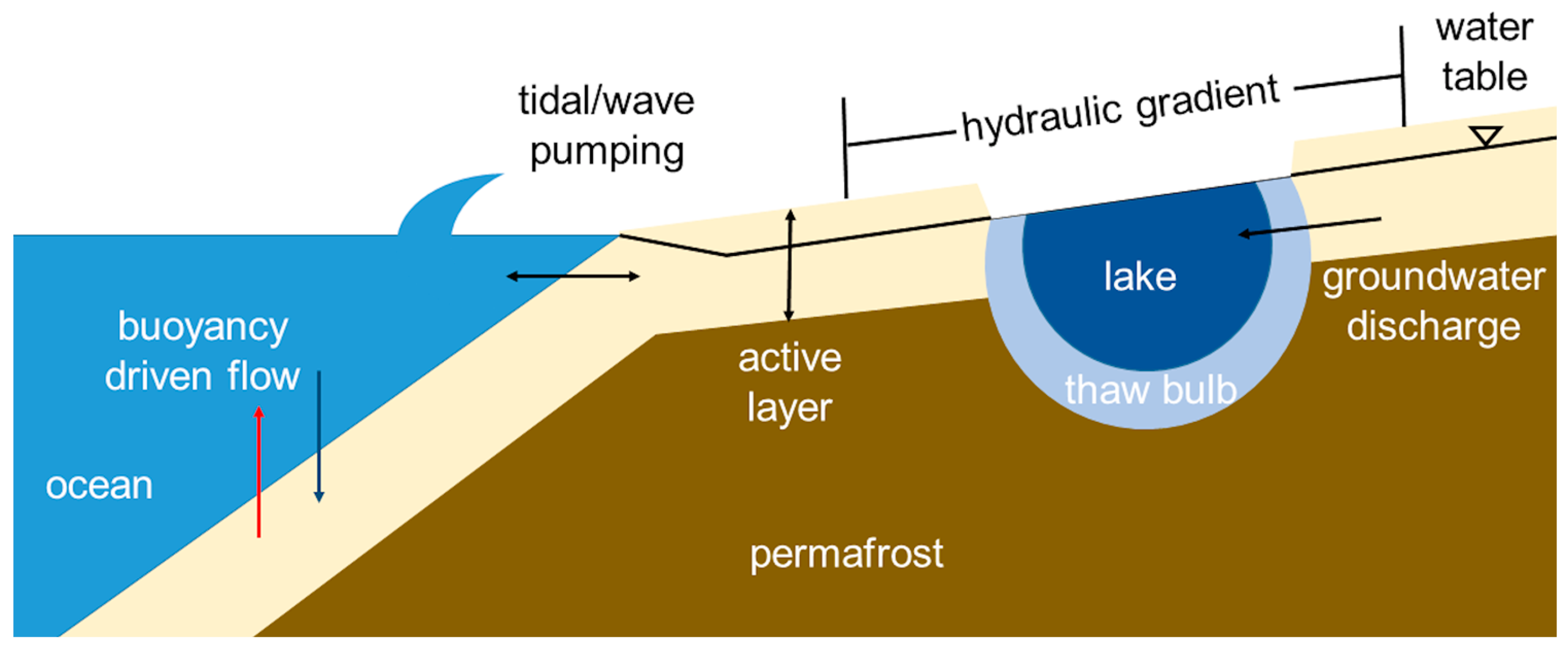
Figure 2.
Locations of studies, as viewed from the geographic North Pole. Numbers correspond to the study sites in Table 1. Figure made using Ocean Data View (Schlitzer, R., Ocean Data View, http://odv.awi.de, 2016).
Figure 2.
Locations of studies, as viewed from the geographic North Pole. Numbers correspond to the study sites in Table 1. Figure made using Ocean Data View (Schlitzer, R., Ocean Data View, http://odv.awi.de, 2016).
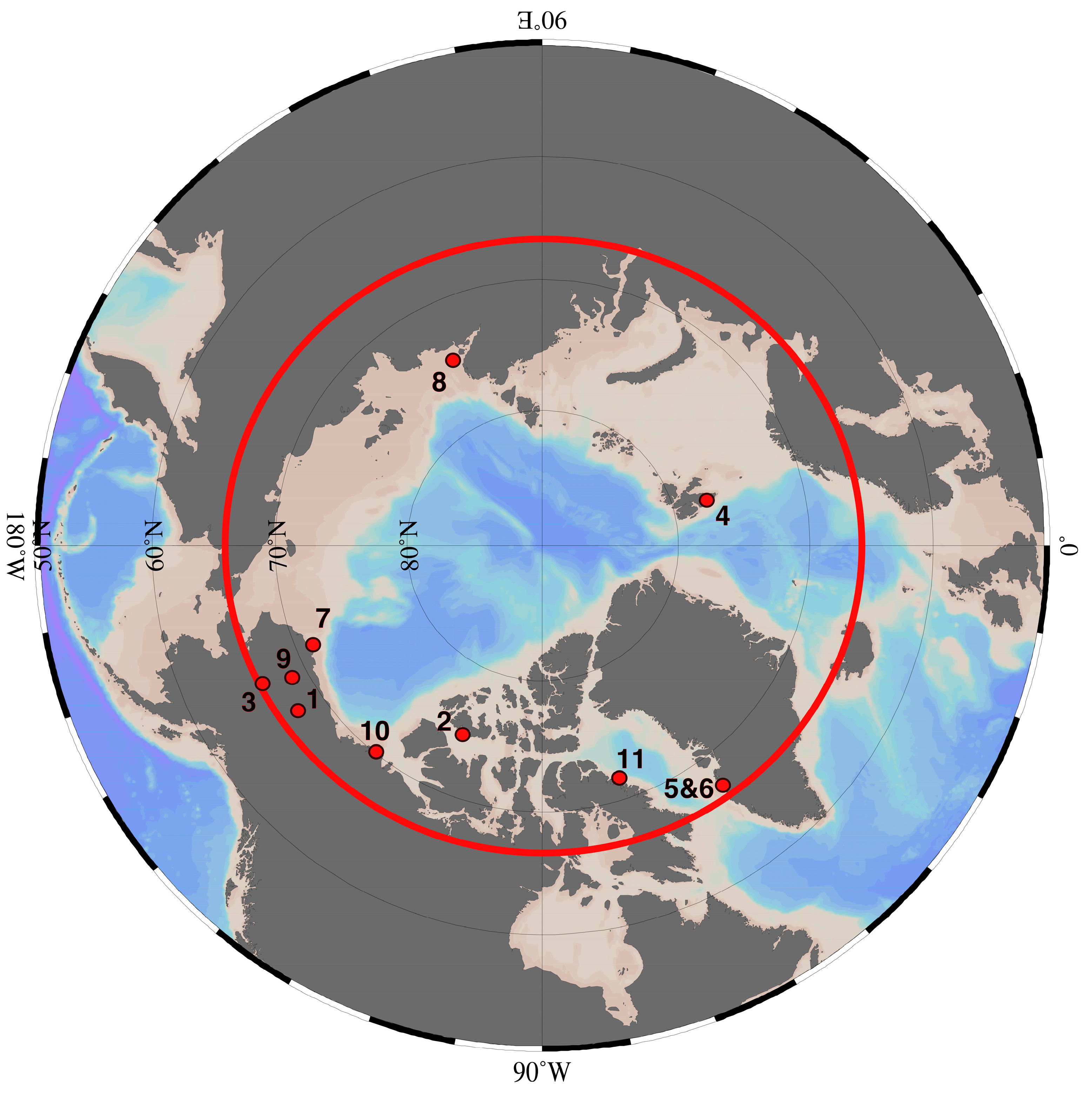
Figure 3.
Calculated contributions of groundwater to river flow in the Yukon River watershed from Walvoord and Striegl [2]. Reprinted with permission.
Figure 3.
Calculated contributions of groundwater to river flow in the Yukon River watershed from Walvoord and Striegl [2]. Reprinted with permission.

Figure 4.
Modeled permafrost extent (y-axis) with time (x-axis, Glacial Cycle) at different fluxes of submarine groundwater discharge (SGD) from Frederick and Buffet [10]. 40 glacial cycles are equivalent to 40,100 ka. The higher the submarine groundwater flux, the more extensive the permafrost extent remains over time. With all simulations beginning at 100% permafrost extent, by the end of the simulations, no SGD resulted in a permafrost extent of 50% of the shelf width, whereas the highest SGD flux of > 140 m3 year−1 m−1 maintained permafrost extent at 100% of the shelf width. Reprinted with permissions.

Figure 5.
A conceptual model of methane–groundwater interactions. The diagram is shown as a cross-section.
Figure 5.
A conceptual model of methane–groundwater interactions. The diagram is shown as a cross-section.


Table 1.
Study sites of Arctic groundwater discharge.
| Figure 2 Number | Location | Groundwater Discharge | Reference(s) |
|---|---|---|---|
| Terrestrial | |||
| 1 | Toolik Lake | 1.6–2.1 × 10⁴ m3 day−1 1.25 ± 1.15 cm day−1 not calculated 3.64 × 10⁴ m3 day−1 | Paytan et al. [20] Dimova et al. [41] Lecher et al. [42] Whalen and Cornwell [29] |
| 2 | Shellabear Lake | not calculated | Dugan et al. [43] |
| 3 | Yukon River Basin | up to 50% of river flow | Walvoord and Striegl [2] |
| 4 | Werenskiold Glacier | not calculated | Kies et al. [44] |
| 5 | Leverette Glacier | 1–5% of river flow | Linhoff et al. [45] |
| 6 | ‘N’ Glacier | 3.4–26% of outflow | Bhatia et al. [46] |
| Marine | |||
| 7 | Barrow | 13.0 ± 0.2 m3 day−1 m−1 1.0 ± 0.3 cm day−1 | Lecher et al. [9] Dimova et al. [41] Lecher et al. [47] |
| 8 | Laptev Sea | not calculated | Charkin et al. [48] |
| 9 | North Slope of Alaska | not calculated | Deming et al. [49] |
| 10 | Mackenzie River Mouth | 60–140 m3 yr−1 m−1 | Frederick and Buffett [10] Frederick and Buffett [50] |
| 11 | Cambridge Fjord | 0.14 m3 s−1 | Hay [51] |
© 2017 by the author. Licensee MDPI, Basel, Switzerland. This article is an open access article distributed under the terms and conditions of the Creative Commons Attribution (CC BY) license (http://creativecommons.org/licenses/by/4.0/).
Share and Cite
MDPI and ACS Style
Lecher, A.L. Groundwater Discharge in the Arctic: A Review of Studies and Implications for Biogeochemistry. Hydrology 2017, 4, 41. https://doi.org/10.3390/hydrology4030041
AMA Style
Lecher AL. Groundwater Discharge in the Arctic: A Review of Studies and Implications for Biogeochemistry. Hydrology. 2017; 4(3):41. https://doi.org/10.3390/hydrology4030041
Chicago/Turabian StyleLecher, Alanna L. 2017. "Groundwater Discharge in the Arctic: A Review of Studies and Implications for Biogeochemistry" Hydrology 4, no. 3: 41. https://doi.org/10.3390/hydrology4030041
Note that from the first issue of 2016, this journal uses article numbers instead of page numbers. See further details here.