How Do We Define Climate Change? Considering the Temporal Resolution of Niveo-Meteorological Data

 ,
,  , and
, and
Abstract
:1. Introduction
2. Study Domain and Data
3. Methodology
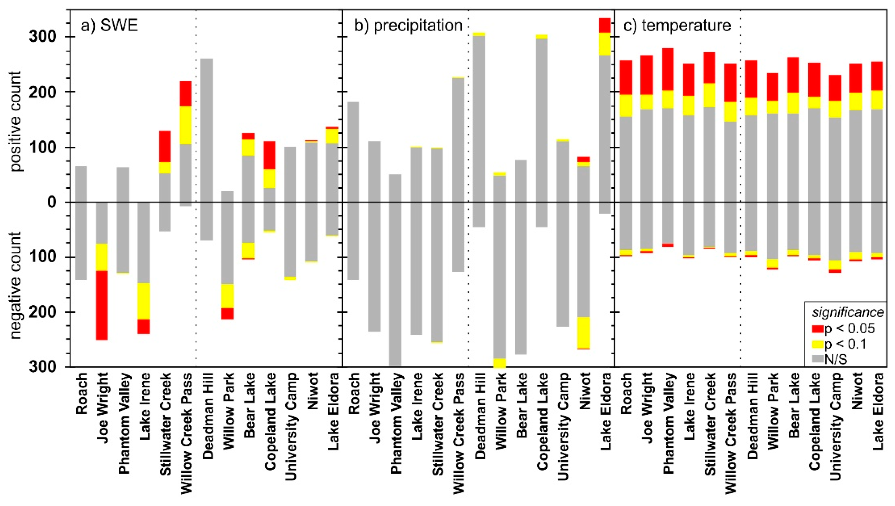
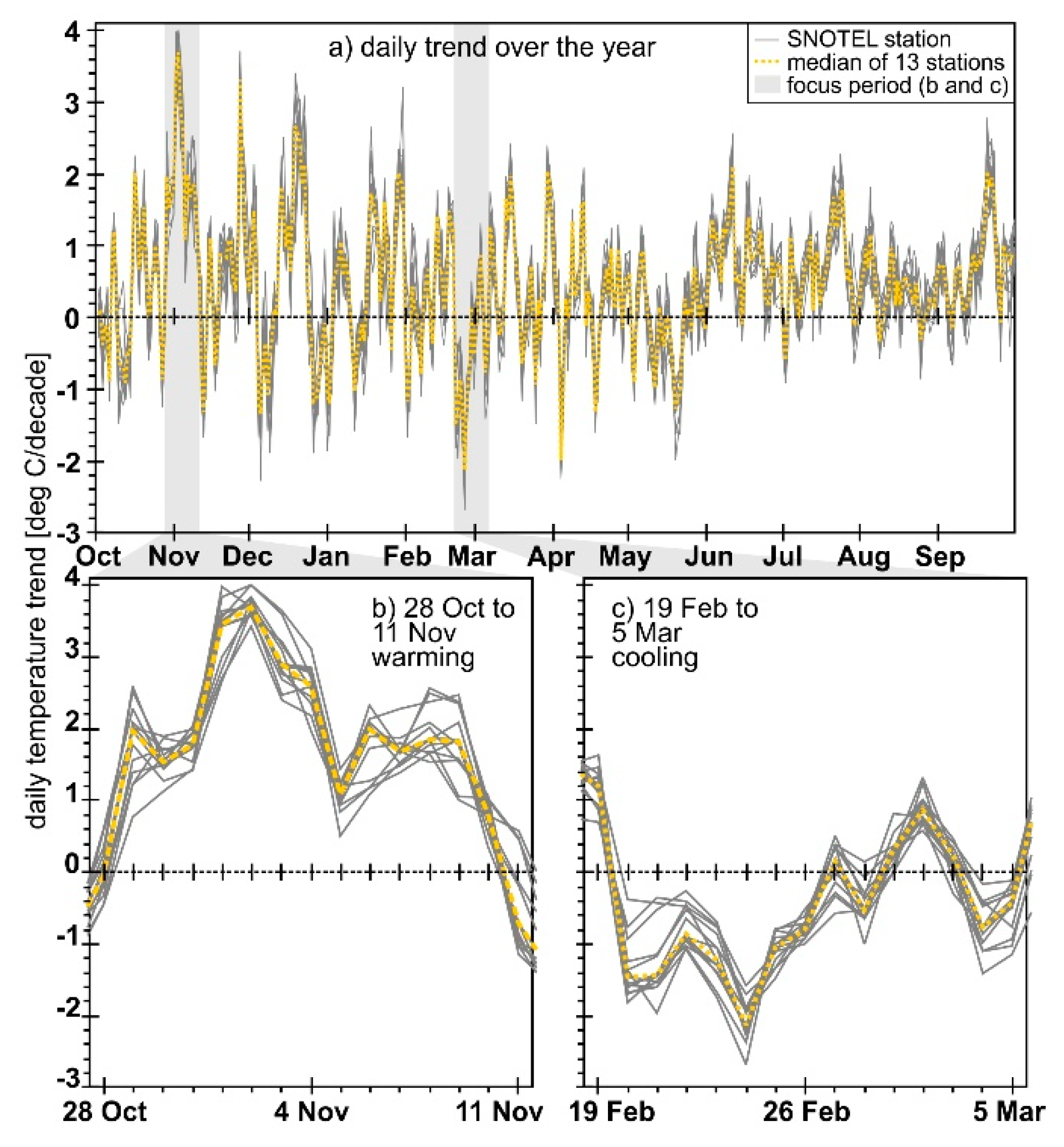
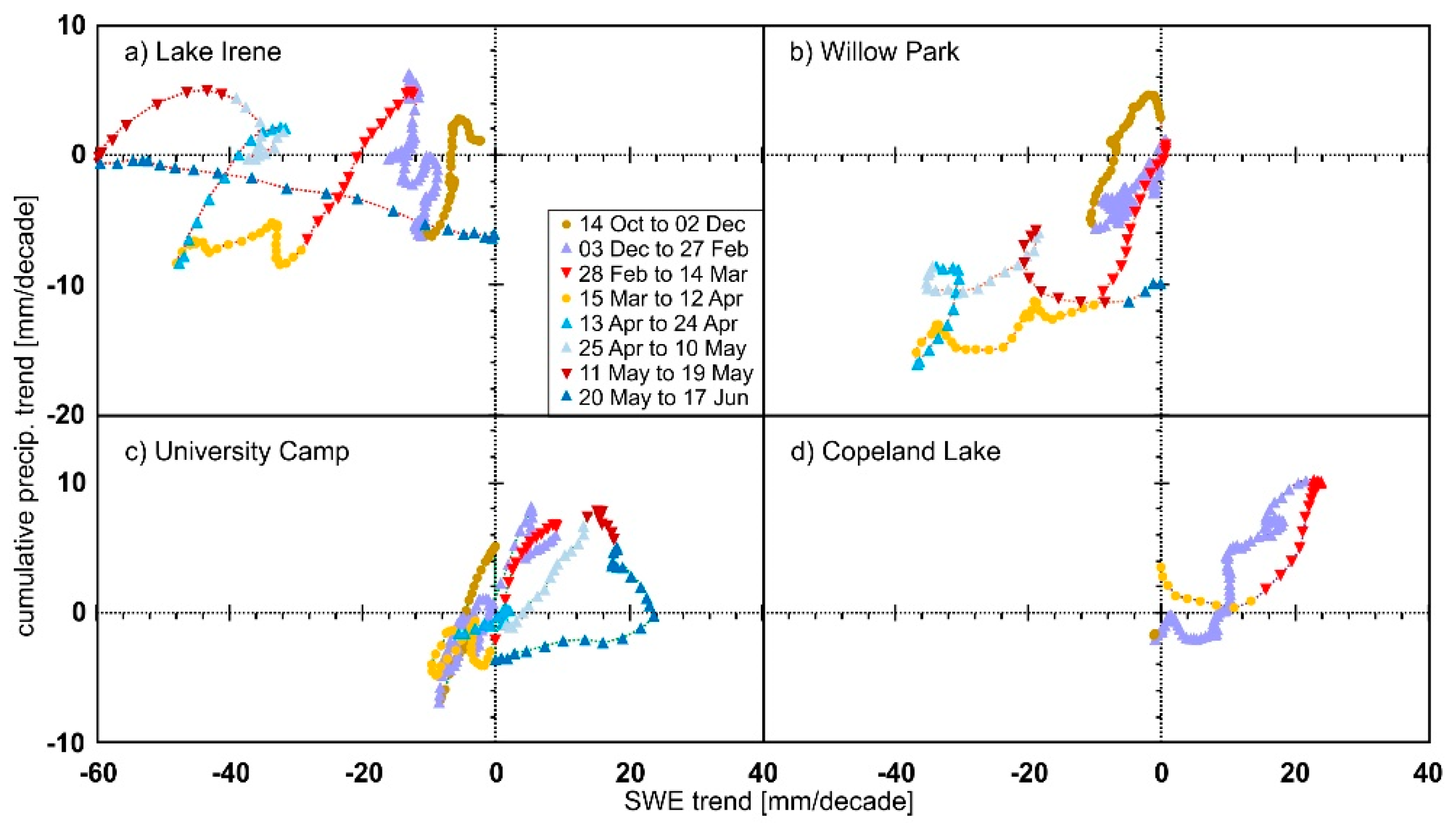
4. Results
5. Discussion
6. Conclusions
Author Contributions
Funding
Acknowledgments
Conflicts of Interest
References
- Richer, E.E.; Kampf, S.K.; Fassnacht, S.R.; Moore, C.C. Spatiotemporal index for analyzing controls on snow climatology: Application in the Colorado Front Range. Phys. Geogr. 2013, 34, 85–107. [Google Scholar] [CrossRef]
- Hammond, J.C.; Saavedra, F.A.; Kampf, S.K. Global snow zone maps and trends in snow persistence 2001–2016. Int. J. Climatol. 2018, 38, 4369–4383. [Google Scholar] [CrossRef]
- Barnett, T.P.; Adam, J.C.; Lettenmaier, D.P. Potential impacts of a warming climate on water availability in snow-dominated regions. Nature 2005, 438, 303–309. [Google Scholar] [CrossRef] [PubMed]
- Barry, R.; Gan, T.Y. The Global Cryosphere, Past, Present and Future; Cambridge University Press: Cambridge, UK, 2011; p. 472. [Google Scholar]
- Qu, X.; Hall, A. Assessing snow albedo feedback in simulated climate change. J. Clim. 2006, 19, 2617–2630. [Google Scholar] [CrossRef] [Green Version]
- Fassnacht, S.R.; Cherry, M.L.; Venable, N.B.H.; Saavedra, F. Snow and albedo climate change impacts across the United States Northern Great Plains. Cryosphere 2016, 10, 329–339. [Google Scholar] [CrossRef] [Green Version]
- Brown, R.D.; Robinson, D.A. Northern Hemisphere spring snow cover variability and change over 1922-2010 including an assessment of uncertainty. Cryosphere 2011, 5, 219–229. [Google Scholar] [CrossRef] [Green Version]
- U.S. Department of Agriculture. Snow survey and water supply forecasting. In National Engineering Handbook; National Water and Climate Center (USDA): Portland, OR, USA, 2011. [Google Scholar]
- Cayan, D.R. Interannual climate variability and snowpack in the western United States. J. Clim. 1996, 9, 928–948. [Google Scholar] [CrossRef] [Green Version]
- Mote, P.W. Trends in snow water equivalent in the Pacific Northwest and their climatic causes. Geophys. Res. Lett. 2003, 30, 1601–1604. [Google Scholar] [CrossRef] [Green Version]
- Hamlet, A.F.; Mote, P.W.; Clark, M.P.; Lettenmaier, D.P. Effects of temperature and precipitation variability on snowpack trends in the western United States. J. Clim. 2005, 18, 4545–4561. [Google Scholar] [CrossRef]
- Regonda, S.K.; Rajagopalan, B.; Clark, M.; Pitlick, J. Seasonal cycle shifts in hydroclimatology over the western United States. J. Clim. 2005, 18, 372–384. [Google Scholar] [CrossRef]
- Pierce, D.W.; Barnett, T.P.; Hidalgo, H.G.; Das, T.; Bonfils, C.; Santer, B.D.; Bala, G.; Dettinger, M.D.; Cayan, D.R.; Mirin, A.; et al. Attribution of Declining Western, U.S. Snowpack to Human Effects. J. Clim. 2008, 21, 6425–6444. [Google Scholar] [CrossRef] [Green Version]
- McCabe, G.J.; Wolock, D.M. Recent declines in western U.S. snowpack in the context of twentieth-century climate variability. Earth Interact. 2009, 13, 1–15. [Google Scholar] [CrossRef]
- Bohr, G.S.; Aguado, E. Use of April 1st SWE measurements as estimates of peak seasonal snowpack and total cold-season precipitation. Water Resour. Res. 2001, 37, 51–60. [Google Scholar] [CrossRef]
- Pagano, T.C. Quantification of the influence of snow course measurement date on climatic trends. Clim. Chang. 2012, 114, 549. [Google Scholar] [CrossRef]
- Fassnacht, S.R.; Venable, N.B.; McGrath, D.; Patterson, G.G. Sub-seasonal snowpack trends in the rocky mountain national park area, Colorado, USA. Water 2018, 10, 562. [Google Scholar] [CrossRef] [Green Version]
- Milly, P.C.D.; Betancourt, J.; Falkenmark, M.; Hirsch, R.M.; Kundzewicz, Z.W.; Lettenmaier, D.P.R.; Stouffer, J.; Dettinger, M.D.; Krysanova, V. On critiques of “stationarity is dead: Whither water management?”. Water Resour. Res. 2015, 51, 7785–7789. [Google Scholar] [CrossRef] [Green Version]
- Fassnacht, S.R.; López-Moreno, J.I. Patterns of trends in niveograph characteristics across the Western United States from snow telemetry data. Front. Earth Sci. 2020, 14. [Google Scholar] [CrossRef]
- Clow, D.W. Changes in the timing of snowmelt and streamflow in Colorado: A response to recent warming. J. Clim. 2010, 23, 2293–2306. [Google Scholar] [CrossRef]
- Harpold, A.; Brooks, P.; Rajagopal, S.; Heidbuchel, I.; Jardine, A.; Stielstra, C. Changes in snowpack accumulation and ablation in the intermountain west. Water Resour. Res. 2012, 48, W11501–W11511. [Google Scholar] [CrossRef] [Green Version]
- Fassnacht, S.R.; Derry, J.E. Defining similar regions of snow in the Colorado River Basin using self-organizing maps. Water Resour. Res. 2010, 46, W04507. [Google Scholar] [CrossRef]
- Fassnacht, S.R.; Deitemeyer, D.C.; Venable, N.B.H. Capitalizing on the daily time step of snow telemetry data to model the snowmelt components of the hydrograph for small watersheds. Hydrol. Process. 2014, 28, 4654–4668. [Google Scholar] [CrossRef]
- Zhang, J.; Zheng, H.; Zhang, X.; VanLooy, J. Changes in regional snowfall in Central North America (1961–2017): Mountain versus plains. Geosciences 2020, 10, 157. [Google Scholar] [CrossRef]
- National Water and Climate Center (USDA). Snow Survey and Water Supply Forecasting Program. Available online: https://www.wcc.nrcs.usda.gov/snotel/program_brochure.pdf (accessed on 18 February 2020).
- Sexstone, G.A.; Fassnacht, S.R. What drives basin scale spatial variability of snowpack properties in the Front Range of Northern Colorado? Cryosphere 2014, 8, 329–344. [Google Scholar] [CrossRef] [Green Version]
- Serreze, M.C.; Clark, M.P.; Armstrong, R.L.; McGinnis, D.A.; Pulwarty, R.S. Characteristics of the Western United States snowpack from snowpack telemetry (SNOTEL) data. Water Resour. Res. 1999, 35, 2145–2160. [Google Scholar] [CrossRef] [Green Version]
- Tumenjargal, S.; Fassnacht, S.R.; Venable, N.B.H.; Kingston, A.P.; Fernández-Giménez, M.E.; Batbuyan, B.; Laituri, M.J.; Kappas, M.; Adyabadam, G. Variability and change of climate extremes from indigenous herder knowledge and at meteorological stations across Central Mongolia. Front. Earth Sci. 2020, 14. [Google Scholar] [CrossRef]
- Julander, R.P.; Curtis, J.; Beard, A. The SNOTEL temperature dataset. Mt. Views Newslett. 2007, 1, 4–7. Available online: http://www.fs.fed.us/psw/cirmount/ (accessed on 18 February 2020).
- Oyler, J.W.; Dobrowski, S.Z.; Ballantyne, A.P.; Klene, A.E.; Running, S.W. Artificial amplification of warming trends across the mountains of the western United States. Geophys. Res. Lett. 2015, 42. [Google Scholar] [CrossRef] [Green Version]
- Ma, C.; Fassnacht, S.R.; Kampf, S.K. How temperature sensor change affects warming trends and modeling–An evaluation across the State of Colorado. Water Resour. Res. 2019, 55, 9748–9764. [Google Scholar] [CrossRef]
- Fassnacht, S.R.; Venable, N.B.H.; Khishigbayar, J.; Cherry, M.L. The probability of precipitation as snow derived from daily air temperature for high elevation Areas of Colorado, United States. In Cold and Mountain Region Hydrological Systems Under Climate Change: Towards Improved Projections, Proceedings of the Symposium H02, IAHS-IAPSO-IASPEI Assembly, Gothenburg, Sweden, 22–26 July 2013; IAHS: Wallingford, UK, 2013; Volume 360, pp. 65–70. [Google Scholar]
- Fassnacht, S.R.; Allegretti, A.M.; Venable, N.B.H.; Fernández-Giménez, M.E.; Tumenjargal, S.; Kappas, M.; Laituri, M.J.; Batbuyan, B.; Pfohl, A.K.D. Merging indigenous knowledge systems and station observations to estimate uncertainty of precipitation change in Central Mongolia. Hydrology 2018, 5, 46. [Google Scholar] [CrossRef] [Green Version]
- Mann, H.B. Non-parametric tests against trend. Econometrica 1945, 13, 163–171. [Google Scholar] [CrossRef]
- Kendall, M.G. Rank Correlation Methods, 4th ed.; Charles Griffin: London, UK, 1975; p. 272. ISBN 978-0195208375. [Google Scholar]
- Gilbert, R.O. Statistical Methods for Environmental Pollution Monitoring; Wiley: New York, NY, USA, 1987; p. 320. ISBN 978-0471288787. [Google Scholar]
- Yue, S.; Pilon, P.; Phinney, B.; Cavadias, G. The influence of autocorrelation on the ability to detect trend in hydrological series. Hydrol. Process. 2002, 16, 1807–1829. [Google Scholar] [CrossRef]
- Theil, H. A rank-invariant method of linear and polynomial regression analysis, 1, 2, and 3. Proc. K. Ned. Akad. Wetenschap. A 1950, 53, 386–392, 521–525, 1397–1412. [Google Scholar]
- Sen, P.K. Estimates of the regression coefficient based on Kendall’s tau. J. Am. Stat. Assoc. 1968, 63, 1379–1389. [Google Scholar] [CrossRef]
- Fassnacht, S.R.; Hultstrand, M. Snowpack variability and trends at long-term stations in Northern Colorado, USA. Proc. Int. Assoc. Hydrol. Sci. 2015, 371, 131–136. [Google Scholar] [CrossRef] [Green Version]
- Venable, N.B.H.; Fassnacht, S.R.; Adyabadam, G.; Tumenjargal, S.; Fernández-Giménez, M.; Batbuyan, B. Does the length of station record influence the warming trend that is perceived by mongolian herders near the Khangai Mountains? Pirineos 2012, 167, 71–88. [Google Scholar] [CrossRef] [Green Version]
- Fassnacht, S.R.; López-Moreno, J.I.; Ma, C.; Weber, A.N.; Pfohl, A.K.D.; Kampf, S.K.; Kappas, M. Spatio-temporal Snowmelt Variability across the Headwaters of the Southern Rocky Mountains. Front. Earth Sci. 2017, 11, 505–514. [Google Scholar] [CrossRef]
- Van Pelt, W.J.J.; Kohler, J.; Liston, G.E.; Hagen, J.O.; Luks, B.; Reijmer, C.H.; Pohjola, V.A. Multidecadal climate and seasonal snow conditions in Svalbard. J. Geophys. Res. Earth Surf. 2016, 121, 2100–2117. [Google Scholar] [CrossRef]
- IPCC. Global Warming of 1.5 °C; An IPCC Special Report on the Impacts of Global Warming of 1.5 °C above Pre-Industrial Levels and Related Global Greenhouse Gas Emission Pathways, in the Context of Strengthening the Global Response to the Threat of Climate Change, Sustainable Development, and Efforts to Eradicate Poverty; Masson-Delmotte, V., Zhai, P., Pörtner, H.-O., Roberts, D., Skea, J., Shukla, P.R., Pirani, A., Moufouma-Okia, W., Péan, C., Pidcock, R., et al., Eds.; Intergovernmental Panel on Climate Change: Geneva, Switzerland, 2018.
- National Park Service. NPS Stats National Park Service Visitor Use Statistics. Available online: https://irma.nps.gov/STATS/Reports/Park (accessed on 23 February 2020).
- National Park Service. Rocky Mountain National Park. 2019. Available online: https://www.nps.gov/romo/index.htm (accessed on 23 February 2020).
- Wang, Z.; Schaaf, C.B.; Strahler, A.H.; Chopping, M.J.; Román, M.O.; Shuai, Y.; Woodcock, C.E.; Hollinger, D.Y.; Fitzjarrald, D.R. Evaluation of MODIS albedo product (MCD43A) over grassland, agriculture and forest surface types during dormant and snow-covered periods. Remote Sens. Environ. 2014, 140, 60–77. [Google Scholar] [CrossRef] [Green Version]
- Burston, R.M.; Kilmister, I.F.; Dee, M.; Campbell, P.A. Out of the sun. In Sacrifice; CMC International Records: Raleigh, NC, USA, 1995. [Google Scholar]
- Tung, C.-P.; Haith, D.A. Global-Warming effects on New York streamflows. J. Water Resour. Plan. Manag. 1995, 121, 216–225. [Google Scholar] [CrossRef]
- Eckhardt, K.; Ulbrich, U. Potential impacts of climate change on groundwater recharge and streamflow in a central European low mountain range. J. Hydrol. 2003, 284, 244–252. [Google Scholar] [CrossRef]
- Stewart, I.T.; Cayan, D.R.; Dettinger, M.D. Changes in snowmelt runoff timing in western North America under a “business as usual” climate change scenario. Clim. Chang. 2004, 62, 217–232. [Google Scholar] [CrossRef]
- Stewart, I.T.; Cayan, D.R.; Dettinger, M.D. Changes toward earlier streamflow timing across western North America. J. Clim. 2005, 18, 1136–1155. [Google Scholar] [CrossRef]
- Fritze, H.; Stewart, I.T.; Pebesma, E. Shifts in western North American snowmelt runoff regimes for the recent warm decades. J. Hydrometeorol. 2011, 12, 989–1006. [Google Scholar] [CrossRef]
- Pfohl, A.K.D.; Fassnacht, S.R. Evaluating methods of streamflow timing to approximate snowmelt contribution in high-elevation mountain watersheds. Geophys. Res. Lett. 2020. in review, submission 2019GL083419. [Google Scholar]
- McCabe, G.J.; Wolock, D.M.; Valentin, M. Warming is driving decreases in snow fractions while runoff efficiency remains mostly unchanged in snow-covered areas of the Western United States. J. Hydrometeor. 2018, 19, 803–814. [Google Scholar] [CrossRef]
- Collados-Lara, A.-J.; Fassnacht, S.R.; Pulido-Velazquez, D.; Pfohl, A.K.D.; Morán-Tejeda, E.; Venable, N.B.H.; Pardo-Igúzquiza, E.; Puntenney-Desmond, K. Intra-day variability of temperature and its lapse rates over mountainous terrain: Comparing MODIS Land Surface Temperature data with coarse and fine scale surface measurements. Int. J. Climatol. 2020, in press. [Google Scholar]
- Huntington, T.G.; Hodgkins, G.A.; Keim, B.D.; Dudley, R.W. Changes in the proportion of precipitation occurring as snow in New England (1949–2000). J. Clim. 2004, 17, 2626–2636. [Google Scholar] [CrossRef]
- Marks, D.; Kimball, J.; Tingey, D.; Link, T.E. The sensitivity of snowmelt processes to climate conditions and forest cover during rain-on-snow: A study of the 1996 Pacific Northwest Flood. Hydrol. Process. 1998, 12, 1569–1587. [Google Scholar] [CrossRef]
- Kapnick, S.B.; Delworth, T.L. Controls of global snow under a changed climate. J. Clim. 2013, 26, 5537–5562. [Google Scholar] [CrossRef]
- Mote, P.W.; Li, S.; Lettenmaier, D.P.; Xiao, M.; Engel, R. Dramatic declines in snowpack in the western US. npj Clim. Atmos. Sci. 2018, 1, 2. [Google Scholar] [CrossRef]
- Meromy, L.; Molotch, N.P.; Link, T.E.; Fassnacht, S.R.; Rice, R. Subgrid variability of snow water equivalent at operational snow stations in the western United States. Hydrol. Process. 2013, 27, 2383–2400. [Google Scholar] [CrossRef]
- Blöschl, G. Scaling issues in snow hydrology. Hydrol. Process. 1999, 13, 2149–2175. [Google Scholar] [CrossRef]
- López-Moreno, J.I.; Fassnacht, S.R.; Heath, J.T.; Musselman, K.; Revuelto, J.; Latron, J.; Morán-Tejedaa, E.; Jonas, T. Spatial variability of snow density over complex alpine terrain: Implications for estimating snow water equivalent. Adv. Water Resour. 2013, 55, 40–52. [Google Scholar] [CrossRef] [Green Version]
- Collados-Lara, A.-J.; Pardo-Igúzquiza, E.; Pulido-Velazquez, D. Spatiotemporal estimation of snow depth using point data from snow stakes, digital terrain models, and satellite data. Hydrol. Process. 2017, 31, 1966–1982. [Google Scholar] [CrossRef]
- López-Moreno, J.I.; Soubeyroux, J.M.; Gascoin, S.; Alonso-Gonzalez, E.; Durán-Gómez, N.; Lafaysse, M.; Vernay, M.; Carmagnola, C.; Morin, S. Long-term trends (1958–2017) in snow cover duration and depth in the Pyrenees. Int. J. Clim. 2020, 1–15. [Google Scholar] [CrossRef]


| Name | # | Lat [°N] | Long [°W] | Elev [m] | Slope [°] | Northness | Canopy Density [%] | Peak SWE [mm] | Annual Temp [°C] | Total Precip [mm] |
|---|---|---|---|---|---|---|---|---|---|---|
| west side orange stations | ||||||||||
| Roach | 718 | 40.88 | 106.05 | 2962 | 6.24 | −0.10 | 75 | 483 | 1.96 | 847 |
| Joe Wright | 551 | 40.53 | 105.89 | 3091 | 9.13 | 0.13 | 87 | 674 | 1.51 | 1132 |
| Phantom Valley * | 688 | 40.40 | 105.85 | 2752 | 3.48 | −0.05 | 0 | 273 | 2.34 | 655 |
| Lake Irene | 565 | 40.41 | 105.82 | 3257 | 11.3 | −0.14 | 70 | 700 | 0.48 | 914 |
| Stillwater Creek | 793 | 40.23 | 105.92 | 2684 | 4.33 | −0.07 | 62 | 220 | 3.72 | 482 |
| Willow Creek Pass | 869 | 40.35 | 106.09 | 2901 | 11.5 | 0.14 | 75 | 404 | 1.12 | 665 |
| east side purple stations | ||||||||||
| Deadman Hill | 438 | 40.81 | 105.77 | 3121 | 5.16 | 0.001 | 58 | 539 | 1.02 | 798 |
| Willow Park | 870 | 40.43 | 105.73 | 3265 | 10.3 | −0.13 | 75 | 545 | 0.65 | 968 |
| Bear Lake | 322 | 40.31 | 105.64 | 2892 | 9.54 | −0.14 | 86 | 527 | 3.72 | 883 |
| Copeland Lake | 412 | 40.21 | 105.57 | 2612 | 9.71 | −0.17 | 75 | 147 | 5.26 | 712 |
| University Camp | 838 | 40.03 | 105.58 | 3148 | 2.42 | −0.03 | 84 | 516 | 1.98 | 953 |
| Niwot | 663 | 40.04 | 105.54 | 3029 | 5.43 | −0.03 | 79 | 367 | 2.78 | 811 |
| Lake Eldora | 564 | 39.94 | 105.59 | 2959 | 5.81 | 0.04 | 69 | 343 | 3.82 | 786 |
© 2020 by the authors. Licensee MDPI, Basel, Switzerland. This article is an open access article distributed under the terms and conditions of the Creative Commons Attribution (CC BY) license (http://creativecommons.org/licenses/by/4.0/).
Share and Cite
Fassnacht, S.R.; Patterson, G.G.; Venable, N.B.H.; Cherry, M.L.; Pfohl, A.K.D.; Sanow, J.E.; Tedesche, M.E. How Do We Define Climate Change? Considering the Temporal Resolution of Niveo-Meteorological Data. Hydrology 2020, 7, 38. https://doi.org/10.3390/hydrology7030038
Fassnacht SR, Patterson GG, Venable NBH, Cherry ML, Pfohl AKD, Sanow JE, Tedesche ME. How Do We Define Climate Change? Considering the Temporal Resolution of Niveo-Meteorological Data. Hydrology. 2020; 7(3):38. https://doi.org/10.3390/hydrology7030038
Chicago/Turabian StyleFassnacht, Steven R., Glenn G. Patterson, Niah B.H. Venable, Mikaela L. Cherry, Anna K.D. Pfohl, Jessica E. Sanow, and Molly E. Tedesche. 2020. "How Do We Define Climate Change? Considering the Temporal Resolution of Niveo-Meteorological Data" Hydrology 7, no. 3: 38. https://doi.org/10.3390/hydrology7030038