Assessing the Influence of Roads on Fire Ignition: Does Land Cover Matter?


1
Department of Environmental Biology, University of Rome ‘La Sapienza’, I-00185 Rome, Italy
2
Council for Agricultural Research and Economics, Research Centre for Agriculture and Environment (CREA-AA), I-00198 Rome, Italy
3
Italian National Research Council, Institute of Environmental Geology and Geoengineering (CNR-IGAG), I-00015 Monterotondo, Italy
4
Insubric Ecosystems Group, Swiss Federal Research Institute (WSL), CH-6593 Cadenazzo, Switzerland
*
Author to whom correspondence should be addressed.
Fire 2018, 1(2), 24; https://doi.org/10.3390/fire1020024
Submission received: 7 June 2018
/
Revised: 6 July 2018
/
Accepted: 7 July 2018
/
Published: 9 July 2018
Abstract
:In human-affected fire environments, assessing the influence of human activities on the spatial distribution of wildfire ignitions is of paramount importance for fire management planning. Previous studies have shown that roads have significant effects on fire ignition. However, since different land cover classes are subject to different levels of ignition risk, roads in different land cover classes may differently affect fire ignition. The aim of this paper is thus to assess the influence of roads on fire ignition in selected land cover classes subjected to different levels of anthropogenic pressure in Sardinia (Italy). Our results show that fires are preferentially ignited close to roads in all land cover classes. However, the influence of roads is much stronger in less impacted land uses, where the availability of human-induced ignitions highly depends on the accessibility networks. Our approach represents a first step towards the systematic integration of interacting fire ignition drivers such as roads and land cover into fire risk analysis.
1. Introduction
Fire characteristics such as type, intensity, spread, and temporal distribution depend on several factors such as climate, fuel load and continuity and ignition sources [1]. In this respect, humans play a manifold role, acting indirectly as fuel shapers through land use and related vegetation, as well as directly by setting and controlling fire [2]. As a consequence, human influence on fire regimes highly varies from region to region worldwide [3].
Several studies demonstrated that in the Mediterranean areas intentional or accidental human-induced fire ignitions account for more than 90% of forest fires [4], thus far exceeding natural fires [5,6]. In such human-affected fire environments, a detailed understanding of the influence of anthropogenic activities on the temporal and spatial distribution of wildfires is a crucial factor for fire management planning [7,8,9]. Given the complexity of the human component of wildfires, quantitative analyses of fire risk have generally paid less attention to the socioeconomic aspects of fire occurrence compared to the biological and physical factors, such as elevation, slope, temperature, rainfall, or vegetation [10,11,12,13,14,15]. In recent years, however, fire risk studies have started to incorporate human-related variables that directly or indirectly influence spatial patterns of fire occurrence. At the landscape scale, a number of authors showed that fire ignitions exhibit strong preferences for given land use/land cover (LULC) types [16,17,18,19,20]. LULCs are the result of human activities, such as agriculture, farming, silviculture, recreation, etc. and are subjected to a different fire ignition risk depending on fuel load and human-induced ignitions. The intrinsic fire selectivity of each LULC is further modulated by the presence of infrastructure such as housing or roads, which are also well known to influence fire ignition [21,22,23,24,25,26,27,28,29]. However, while LULC data and distance from roads have been already used for modeling fire ignition risk e.g., [30,31,32,33], to the best of our knowledge, a detailed analysis of the combined effect of road network and land cover is provided here for the first time.
The objective of this paper is thus to assess the influence of roads on fire ignition in selected land cover classes subjected to different levels of anthropogenic pressure in Sardinia (Italy). To achieve this aim, we referred to a selectivity index according to which certain resources (i.e., land cover classes) are more fire-prone than others, being differentially selected by fire, depending on fuel load, structure, spatial continuity and human activities [5,16,17,18]. Fire is considered selective towards a resource (i.e., land cover type) when such resource is used disproportionately to their availability [16,17]. By integrating the selectivity behaviour of fire towards LULC and the road network, this paper can provide insights into the interaction between these two fire drivers.
2. Materials and Methods
2.1. Study Area
Sardinia is the second largest island of the Mediterranean basin, with a total surface area of approximately 24,000 km2 (Figure 1). The island is characterized by a prevalently hilly topography and extreme heterogeneity in geological and geomorphological features. The highest peak is Punta La Marmora (1834 m a.s.l.), located in central Sardinia. The climate of Sardinia is typically Mediterranean with a mild and rainy period from October to May and a warm and dry period from June to September when temperatures may reach peaks above 30 °C. The average annual amount of precipitation ranges from 500 mm along the coasts to more than 1200 mm in the higher regions [34].
Sardinia hosts a very high ecosystem diversity, with habitats ranging from coastal sand dunes to extensive maquis and forests in the mountains. Land use is shaped by a long human history. Urban areas cover 3% of Sardinia, and the two main cities of Cagliari and Sassari are where most of the 1.7 million inhabitants are concentrated. Agricultural areas represent 25% of the island, whereas approximately 15% is covered by broadleaf forests, mainly composed of Mediterranean oaks, such as Quercus ilex, Q. suber and Q. pubescens. Mediterranean maquis and garrigue cover an additional 23%.
Sardinia is also considered to be a wildfire hotspot, with more than 2500 events per year on average [35]. Like in many other regions of southern Europe, the majority of fires directly originate from human activities. However, in recent decades the pronounced summer aridity combined with the abandonment of the traditional agriculture and the resulting progressive built up of fuel increased the risk of large and severe fires. Mean yearly burnt area is approximately 14,500 ha. More than 86% of fires occur from June to September with a peak in July. Fire size ranges over many orders of magnitude from 0.01 ha to >1000 ha, although less than 1% of total events get larger than 100 ha. However, fires > 100 ha account for roughly 51% of the total area burned in Sardinia between 2000 and 2015. Detailed statistics on fire causes are not available. Like in most Mediterranean regions, we can however assume that almost all fire events are of anthropogenic origin.
2.2. Data Preprocessing
A dataset of 45,976 wildfire events that occurred in Sardinia between 2000 and 2015 was extracted from the digital database of the Regional Forest Service (Figure 1). For each record, the dataset includes the date and the geographic coordinates of fire ignition and a field estimate of the burned area. The ignition points of the most recent fires (from 2006 onwards) are usually accurately geolocated with GPS, while the positional accuracy of the older ignition points is more uncertain.
For analyzing the relationship between fires, land cover and road network, we used a road network map containing all state, regional and county roads of Sardinia, together with a LULC map of the island at scale 1:25,000. The LULC map was built by the Regional Administration of Sardinia according to the standard classification methodology of the CORINE Land Cover legend [36] based on 2003–2004 digital orthophotos and high-resolution Ikonos satellite images (2005–2006) combined with field surveys. Both maps were downloaded from the Regional geographic information portal of Sardinia (www.sardegnageoportale.it).
We next selected eight land cover classes with a sufficient number of fire records for studying fire incidence patterns at the landscape scale: (i) discontinuous urban areas, (ii) arable land, (iii) mixed agriculture, (iv) olive groves, (v) deciduous forests, (vi) maquis, (vii) garrigue, (viii) pastures. The selected classes were grouped into two main categories with different levels of anthropogenic pressure according to the CORINE Land Cover classification [36]: Artificial and agricultural classes (i–iv) and Natural and semi-natural classes (v–viii).
2.3. Data Analysis
We first created a sequence of overlapping buffers around the road network, ranging from 0 to 200 m in four steps of 50 m each (i.e., 0–50 m, 0–100 m, 0–150 m and 0–200 m). The buffers were then intersected with the selected LULCs to calculate the area of each land cover class k within each buffer b. Next, the number of fires within each land cover class in each buffer were counted (Table 1).
The actual number of fires was then compared with the expected number of fires assuming complete spatial randomness in fire distribution within each land cover class (, implying that distance to roads does not influence the spatial distribution of fires within single LULC classes) and within each buffer (, implying that distance to roads does not influence the relative proportion of fires among different LULC classes). For land cover class k, the number of fires in a given buffer b expected under is obtained by multiplying the total number of fires in that land cover class by the proportional area of that class within the buffer relative to the total area of k over the entire study area (). The expected number of fires in class k within buffer b is then
Likewise, for a given land cover class k, the number of fires in a given buffer b expected under is obtained by multiplying the total number of fires in that buffer by the proportional area of that class within the buffer relative to the total area of buffer b (). The expected number of fires in class k under is then
To compare the actual number of fires in class k within buffer b with the corresponding expected values and , we finally calculated the normalized selectivity indices
And
thus summarizes the degree of fire clustering of a given land cover class k in a given buffer b compared to the fire distribution within the whole land cover class, while summarizes the degree of fire clustering of class k in buffer b compared to the fire distribution within the whole buffer. Both indices range from −1 to +1. Values of represent areas where fire occurs more frequently than expected under complete spatial randomness in fire distribution within each land cover class () or within each buffer (), meaning that these areas are positively selected by fire. By contrast, values of represent areas where ignitions are less frequent than expected under complete spatial randomness, meaning that these areas are negatively selected by fires [18].
3. Results
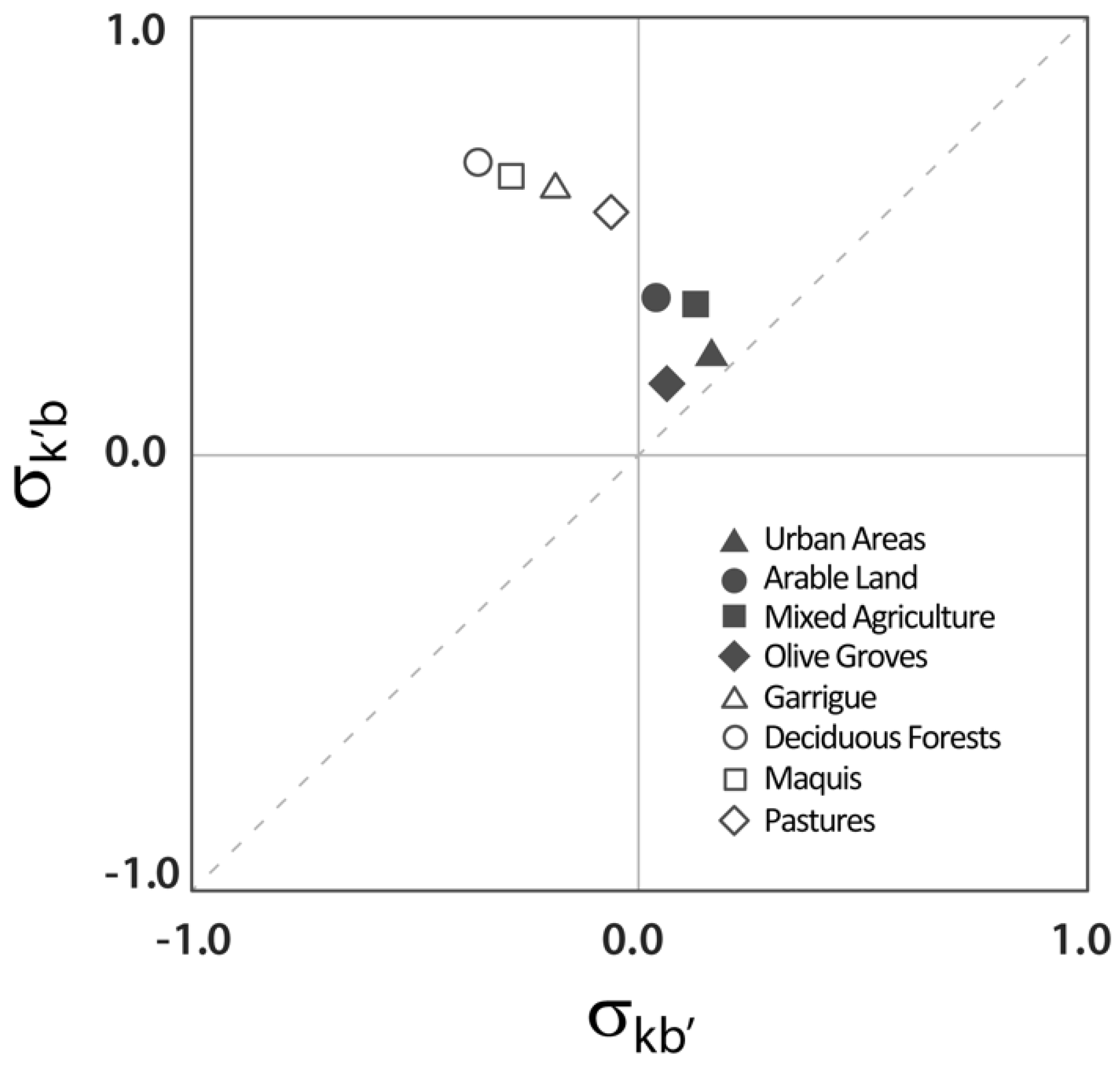
The selectivity values of and for all buffers and land cover classes are shown in Table 2, while Figure 2 shows the plot of vs. for the 100-m buffer only. Note that, as shown in Table 2, the results obtained for the 100-m buffer are qualitatively and quantitatively consistent with the results obtained for the other buffers.
According to Figure 2, the values of show that relative fire occurrence close to roads is higher than expected by chance alone in all LULC classes, meaning that for every land cover class, the proportion of fires close to roads is significantly higher compared to with respect to more interior areas of the same class. Nonetheless, this ‘clustering effect’ tends to be much lower for classes with high human pressure (i.e., urban areas, arable land, mixed agricultural land, and olive groves) than for natural and semi-natural classes (i.e., pastures, deciduous forests, garrigue, maquis) where the occurrence of human-related ignitions highly depends on the proximity to accessibility networks.
At the same time, the values of show that land uses with high anthropogenic pressure experience a disproportionately higher number of ignitions than expected under complete spatial randomness in fire distribution within each buffer (). By contrast, in forests and semi-natural LULC classes, the number of ignitions is generally lower than expected by chance alone (). As a result, all natural and semi-natural land uses are located in the upper-left portion of the plot of vs. , which is characterized by positive values of and negative values of , whereas all anthropogenic land uses are located in the upper-right quadrant in which both variables assume positive values.
4. Discussion
There has been a long research tradition focusing on the socio-economic aspects of wildfire [17,30,33,37,38,39,40]. In this study, we analyzed existing interactions between roads and land cover in driving fire ignition. Despite existing uncertainties in terms of the geolocation of a subset of ignition points, the very consistent patterns of the influence of roads and LULC classes on fire ignitions obtained throughout the buffer sizes allow us to assume a strong consistency of the overall results. According to our results, fires are preferentially ignited close to roads in all LULC classes. This effect is consistent with a number of previous studies in various ecosystems, which showed a high spatial clustering of human-caused fire ignitions around accessibility networks [8,9,22,25,41,42,43]. However, the observed influence of roads on the spatial pattern of fire ignitions is not the same in all LULC classes. It is particularly noticeable for the natural and semi-natural land uses, which usually experience a lower number of fires compared to more human-impacted land uses and for which roads represent the major vector of anthropogenic ignition energy [29]. By contrast, in LULC classes with high anthropogenic pressure, the ubiquity of the ignition energy related to the constant and widespread presence of humans reduces the clustering effect of the road network on fire ignitions.
In LULC classes with coarser fuels, such as deciduous forests or maquis, road corridors may directly influence ignition risk by reducing canopy closure, thus affecting the environmental conditions along road edges through increased solar radiation, temperature and wind speed, and reduced fuel moisture content [25]. These edge effects are not limited to the immediate neighborhoods of roads, but extend over a wider area in which fuel conditions are altered compared to continuous forest sites. The peculiar fuel characteristics of road edges have led [25]) to consider them as a separate and specific landscape component in terms of fuel proprieties that differ from the adjacent interior areas.
These results are of relevance for land and forest managers who have to be aware that planned roads and extensions of the road network may have different impacts on the potential of fire ignitions according to the land uses in the concerned area. In this sense, the increased ignition risk related to increasing housing and road density as postulated by [44] may be additionally modulated by the vegetation types crossed by roads.
To conclude, the proposed approach represents a first step towards the integration and the detailed assessment of two major fire ignition drivers, such as land cover and road network, which represent a basic input to fire risk analysis and modern fire management planning [45,46]. A thorough knowledge of the joint effect of LULC and roads on fire ignition patterns is a key point, yet future studies should also take into account fire size and severity in order to fully understand the role of anthropogenic presence in fire regimes.
Author Contributions
Conceptualization, C.R. and M.C.; Data curation, D.G.; Formal analysis, C.R., S.B. and D.G.; Methodology, C.R.; Writing—original draft, C.R.; Writing–review & editing, S.B. and M.C.
Funding
This research received no external funding.
Conflicts of Interest
The authors declare no conflict of interest.
References
- Krebs, P.; Pezzatti, G.B.; Mazzoleni, S.; Talbot, L.M.; Conedera, M. Fire regime: History and definition of a key concept in disturbance ecology. Theory Biosci. 2010, 129, 53–69. [Google Scholar] [CrossRef] [PubMed]
- Pyne, S.J. World Fire: The Culture of Fire on Earth; Henry Holt and Company: New York, NY, USA, 1995. [Google Scholar]
- Bowman, D.M.J.S.; O’Brien, J.A.; Goldammer, J.G. Pyrogeography and the global quest for sustainable fire management. Annu. Rev. Environ. Resour. 2013, 38, 57–80. [Google Scholar] [CrossRef]
- FAO. Fire Management—Global Assessment 2006; FAO Forestry Paper 151; FAO: Rome, Italy, 2007. [Google Scholar]
- Ganteaume, A.; Camia, A.; Jappiot, M.; San-Miguel-Ayanz, J.; Long-Fourne, l.M.; Lampin, C. A review of the main driving factors of forest fire ignition over Europe. Environ. Manag. 2013, 51, 651–662. [Google Scholar] [CrossRef] [PubMed]
- Moreno, M.V.; Chuvieco, E. Characterising fire regimes in Spain from fire statistics. Int. J. Wildland Fire 2013, 22, 296–305. [Google Scholar] [CrossRef]
- Cardille, J.A.; Ventura, S.J.; Turner, M.G. Environmental and social factors influencing wildfires in the Upper Midwest, United States. Ecol. Appl. 2001, 11, 111–127. [Google Scholar] [CrossRef]
- Syphard, A.D.; Radeloff, V.C.; Keeley, J.E.; Hawbaker, T.J.; Clayton, M.K.; Stewart, S.I.; Hammer, R.B. Human influence on California fire regimes. Ecol. Appl. 2007, 17, 1388–1402. [Google Scholar] [CrossRef] [PubMed]
- Syphard, A.D.; Radeloff, V.C.; Keuler, N.S.; Taylor, R.S.; Hawbaker, T.J.; Stewart, S.I.; Clayton, M.K. Predicting spatial patterns of fire on a southern California landscape. Int. J. Wildland Fire 2008, 17, 602–613. [Google Scholar] [CrossRef]
- Vázquez, A.; Moreno, J.M. Sensitivity of fire occurrence to meteorological variables in Mediterranean and Atlantic areas of Spain. Landsc. Urban Plan. 1993, 24, 129–142. [Google Scholar] [CrossRef]
- Viegas, D.X.; Viegas, M.T. A relationship between rainfall and burned area for Portugal. Int. J. Wildland Fire 1994, 4, 11–16. [Google Scholar] [CrossRef]
- Vázquez, A.; Pérez, B.; Fernández-González, F.; Moreno, J.M. Recent fire regime characteristics and potential natural vegetation relationships in Spain. J. Veg. Sci. 2002, 13, 663–676. [Google Scholar] [CrossRef]
- Lloret, F.; Pausas, J.G.; Vilà, M. Response of Mediterranean plant species to different fire regimes in Garraf Natural Park (Catalonia, Spain): Field observations and modelling predictions. Plant Ecol. 2003, 167, 223–235. [Google Scholar] [CrossRef]
- Flannigan, M.D.; Krawchuk, M.A.; de Groot, W.J.; Wotton, B.M.; Gowman, L.M. Implications of changing climate for global wildland fire. Int. J. Wildland Fire 2009, 18, 483–507. [Google Scholar] [CrossRef]
- Wotton, B.M.; Nock, C.A.; Flannigan, M.D. Forest fire occurrence and climate change in Canada. Int. J. Wildland Fire 2010, 19, 253–271. [Google Scholar] [CrossRef]
- Moreira, F.; Ferreira, P.G.; Rego FC Bunting, S. Landscape changes and breeding bird assemblages in northwestern Portugal: The role of fire. Landsc. Ecol. 2001, 16, 175–187. [Google Scholar] [CrossRef]
- Nunes, M.C.S.; Vasconcelos, M.J.; Pereira, J.M.C.; Dasgupta, N.; Alldredge, R.J. Land cover type and fire in Portugal: Do fires burn land cover selectively? Landsc. Ecol. 2005, 20, 661–673. [Google Scholar] [CrossRef]
- Bajocco, S.; Ricotta, C. Evidence of selective burning in Sardinia (Italy): Which land-cover classes do wildfires prefer? Landsc. Ecol. 2008, 23, 241–248. [Google Scholar] [CrossRef]
- Conedera, M.; Torriani, D.; Neff, C.; Ricotta C Bajocco, S.; Pezzatti, G.B. Using Monte Carlo simulations to estimate relative fire ignition danger in a low-to-medium fire-prone region. For. Ecol. Manag. 2011, 261, 2179–2187. [Google Scholar] [CrossRef]
- Guglietta, D.; Migliozzi, A.; Ricotta, C. A multivariate approach for mapping fire ignition risk: The example of the National Park of Cilento (Southern Italy). Environ. Manag. 2015, 56, 157–164. [Google Scholar] [CrossRef] [PubMed]
- Martell, D.L.; Otukol, S.; Stocks, B.J. A logistic model for predicting daily people-caused forest fire occurrence in Ontario. Can. J. For. Res. 1987, 17, 394–401. [Google Scholar] [CrossRef]
- Yang, J.; He, H.S.; Shifley, S.R.; Gustafson, E.J. Spatial patterns of modern period human-caused fire occurrence in the Missouri Ozark Highlands. For. Sci. 2007, 53, 1–15. [Google Scholar]
- Lampin-Maillet, C.; Jappiot, M.; Long, M.; Morge, D.; Ferrier, J.P. Characterization and mapping of dwelling types for forest fire prevention. Comput. Environ. Urban Syst. 2009, 33, 224–232. [Google Scholar] [CrossRef] [Green Version]
- Lampin-Maillet, C.; Jappiot, M.; Long, M.; Bouillon, C.; Morge, D.; Ferrier, J.P. Mapping wildland-urban interfaces at large scales integrating housing density and vegetation aggregation for fire prevention in the South of France. J. Environ. Manag. 2010, 91, 732–741. [Google Scholar] [CrossRef] [PubMed] [Green Version]
- Narayanaraj, G.; Wimberly, M.C. Influences of forest roads on the spatial patterns of human- and lightning-caused wildfire ignitions. Appl. Geogr. 2012, 32, 878–888. [Google Scholar] [CrossRef]
- Narayanaraj, G.; Wimberly, M.C. Influences of forest roads and their edge effects on the spatial pattern of burn severity. Int. J. Appl. Earth Obs. Geoinf. 2013, 23, 62–70. [Google Scholar] [CrossRef]
- Penman, T.D.; Bradstock, R.A.; Price, O. Modelling the determinants of ignition in the Sydney Basin, Australia: Implications for future management. Int. J. Wildland Fire 2013, 22, 469–478. [Google Scholar] [CrossRef]
- Pezzatti, G.B.; Zumbrunnen, T.; Bürgi, M.; Ambrosetti, P.; Conedera, M. Fire regime shifts as a consequence of fire policy and socio-economic development: An analysis based on the change point approach. For. Policy Econ. 2013, 29, 7–18. [Google Scholar] [CrossRef]
- Conedera, M.; Tonini, M.; Oleggini, L.; Vega Orozco, C.; Leuenberger, M.; Pezzatti, G.B. Geospatial approach for defining the Wildland-Urban Interface in the Alpine environment. Comput. Environ. Urban Syst. 2015, 52, 10–20. [Google Scholar] [CrossRef]
- Romero-Calcerrada, R.; Novillo, C.J.; Millington, J.D.A.; Gomez-Jimenez, I. GIS analysis of spatial patterns of human-caused wildfire ignition risk in the SW of Madrid (Central Spain). Landsc. Ecol. 2008, 23, 341–354. [Google Scholar] [CrossRef]
- Ager, A.A.; Preisler, H.K.; Arca, B.; Spano, D.; Salis, M. Wildfire risk estimation in the Mediterranean area. Environmetrics 2014, 25, 384–396. [Google Scholar] [CrossRef]
- Vilar, L.; Gómez, I.; Martínez-Vega, J.; Echavarría, P.; Riaño, D.; Martín, M.P. Multitemporal Modelling of Socio-Economic Wildfire Drivers in Central Spain between the 1980s and the 2000s: Comparing Generalized Linear Models to Machine Learning Algorithms. PLoS ONE 2016, 11, e0161344. [Google Scholar] [CrossRef] [PubMed]
- Ye, J.X.; Wu, M.S.; Deng, Z.J.; Xu, S.J.; Zhou, R.L.; Clarke, K.C. Modeling the spatial patterns of human wildfire ignition in Yunnan province, China. Appl. Geogr. 2017, 89, 150–162. [Google Scholar] [CrossRef] [Green Version]
- Salis, M.; Ager, A.A.; Alcasena, F.J.; Arca, B.; Finney, M.A.; Pellizzaro, G.; Spano, D. Analyzing seasonal patterns of wildfire exposure factors in Sardinia, Italy. Environ. Monit. Assess 2015, 187, 4175. [Google Scholar] [CrossRef] [PubMed]
- Bajocco, S.; Dragozi, E.; Gitas, I.; Smiraglia, D.; Salvati, L.; Ricotta, C. Mapping forest fuels through vegetation phenology: The role of coarse-resolution satellite time-series. PLoS ONE 2015, 10, e0119811. [Google Scholar] [CrossRef] [PubMed]
- ISPRA. La Realizzazione in Italia del Progetto Corine Land Cover 2006; Rapporto 131; Istituto Superiore per la Protezione e la Ricerca Ambientale: Rome, Italy, 2010. [Google Scholar]
- Nunes, A.N.; Lourenco, L.; Meira, A.C.C. Exploring spatial patterns and drivers of forest fires in Portugal (1980–2014). Sci. Total Environ. 2016, 573, 1190–1202. [Google Scholar] [CrossRef] [PubMed]
- Oliveira, S.; Pereira, J.M.C.; San-Miguel-Ayanz, J.; Lourenco, L. Exploring the spatial patterns of fire density in Southern Europe using Geographically Weighted Regression. Appl. Geogr. 2014, 51, 143–157. [Google Scholar] [CrossRef]
- Syphard, A.D.; Keeley, J.E. Location, timing and extent of wildfire vary by cause of ignition. Int. J. Wildland Fire 2015, 24, 37–47. [Google Scholar] [CrossRef]
- Costafreda-Aumedes, S.; Comas, C.; Vega-Garcia, C. Human-caused fire occurrence modelling in perspective: A review. Int. J. Wildland Fire 2017, 26, 983–998. [Google Scholar] [CrossRef]
- Yang, J.; He, H.S.; Sturtevant, B.R.; Miranda, B.R.; Gustafson, E.J. Comparing effects of fire modeling methods on simulated fire patterns and succession: A case study in the Missouri Ozarks. Can. J. For. Res. 2008, 38, 1290–1302. [Google Scholar] [CrossRef]
- Vega Orozco, C.; Tonini, M.; Conedera, M.; Kanevski, M. Cluster recognition in spatial-temporal sequences: The case of forest fires. Geoinformatica 2012, 16, 653–673. [Google Scholar] [CrossRef]
- Ricotta, C.; Di Vito, S. Modeling the Landscape Drivers of Fire Recurrence in Sardinia (Italy). Environ. Manag. 2014, 53, 1077–1084. [Google Scholar] [CrossRef] [PubMed]
- Theobald, D.M.; Romme, W.H. Expansion of the US wildland-urban interface. Landsc. Urban Plan. 2007, 83, 340–354. [Google Scholar] [CrossRef]
- Finney, M.A. The challenge of quantitative risk analysis for wildland fire. For. Ecol. Manag. 2005, 211, 97–108. [Google Scholar] [CrossRef]
- Curt, T.; Borgniet, L.; Bouillon, C. Wildfire frequency varies with the size and shape of fuel types in southeastern France: Implications for environmental management. J. Environ. Manag. 2013, 117, 150–161. [Google Scholar] [CrossRef] [PubMed]
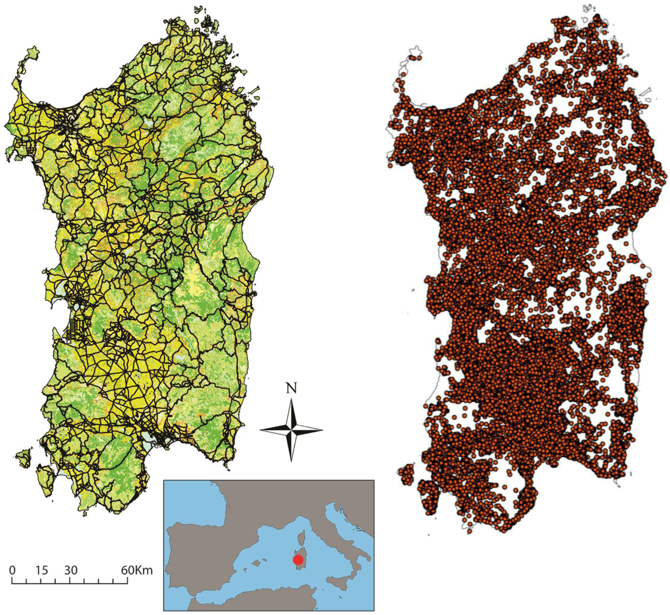
Figure 1.
The study area of Sardinia with the road network used in this paper and the fire ignitions recorded during 2000–2015.
Figure 1.
The study area of Sardinia with the road network used in this paper and the fire ignitions recorded during 2000–2015.

Figure 2.
Plot of (fire selectivity related to land cover) vs. ( fire selectivity related to buffer size) for the 100-m buffer. Gray symbols represent artificial and agricultural Classes, open symbols represent natural and semi-natural classes.
Figure 2.
Plot of (fire selectivity related to land cover) vs. ( fire selectivity related to buffer size) for the 100-m buffer. Gray symbols represent artificial and agricultural Classes, open symbols represent natural and semi-natural classes.


Table 1.
Number of fires and areal extent of the selected land cover classes within each buffer.
| Land Cover Class | Number of Fires within Each Buffer | Total Number of Fires within Each Class | ||||
|---|---|---|---|---|---|---|
| 0–50 m | 0–100 m | 0–150 m | 0–200 m | |||
| Artificial and agricultural | Discontinuous urban areas | 365 | 624 | 793 | 931 | 1366 |
| Arable land | 1829 | 3332 | 4507 | 5429 | 10,599 | |
| Mixed agriculture | 1023 | 1888 | 2496 | 3025 | 5889 | |
| Olive groves | 279 | 512 | 711 | 893 | 2012 | |
| Natural and semi-natural | Deciduous forests | 320 | 581 | 789 | 943 | 2113 |
| Maquis | 332 | 596 | 788 | 955 | 2443 | |
| Garrigue | 230 | 442 | 609 | 755 | 1916 | |
| Pastures | 278 | 526 | 684 | 827 | 1951 | |
| Total number of fires within each buffer | 7326 | 13,499 | 18,272 | 22,234 | ||
| Land Cover Class | Class Area within Each Buffer (ha) | Total Class Area (ha) | ||||
| 0–50 m | 0–100 m | 0–150 m | 0–200 m | |||
| Artificial and agricultural | Discontinuous urban areas | 4536 | 8143 | 10,983 | 13,238 | 29,899 |
| Arable land | 29,714 | 57,249 | 82,805 | 106,326 | 415,700 | |
| Mixed agriculture | 14,791 | 28,168 | 40,264 | 51,162 | 199,000 | |
| Olive groves | 4353 | 8458 | 12,290 | 15,803 | 48,780 | |
| Natural and semi-natural | Deciduous forests | 9493 | 18,703 | 27,653 | 36,509 | 351,400 |
| Maquis | 9052 | 17,666 | 25,998 | 34,235 | 345,716 | |
| Garrigue | 5760 | 11,356 | 16,872 | 22,457 | 220,000 | |
| Pastures | 5544 | 10,794 | 15,725 | 20,477 | 144,800 | |
| Total area of each buffer (ha) | 123,721 | 238,490 | 345,267 | 444,967 | ||
Table 2.
Values of the selectivity indices and for the selected land cover classes within each buffer.
Table 2.
Values of the selectivity indices and for the selected land cover classes within each buffer.
| Land Cover Class | Selectivity Related to Land Cover | Selectivity Related to Buffer Size | |||||||
|---|---|---|---|---|---|---|---|---|---|
| 0–50 m | 0–100 m | 0–150 m | 0–200 m | 0–50 m | 0–100 m | 0–150 m | 0–200 m | ||
| Artificial and agricultural | Discontinuous urban areas | 0.276 | 0.253 | 0.225 | 0.212 | 0.152 | 0.150 | 0.154 | 0.169 |
| Arable land | 0.414 | 0.391 | 0.362 | 0.334 | 0.019 | 0.014 | 0.014 | 0.011 | |
| Mixed agriculture | 0.401 | 0.387 | 0.354 | 0.333 | 0.078 | 0.084 | 0.079 | 0.084 | |
| Olive groves | 0.217 | 0.190 | 0.168 | 0.156 | 0.040 | 0.034 | 0.045 | 0.061 | |
| Natural and semi-natural | Deciduous forests | 0.697 | 0.676 | 0.652 | 0.622 | −0.274 | −0.291 | −0.299 | −0.318 |
| Maquis | 0.677 | 0.654 | 0.622 | 0.596 | −0.235 | −0.253 | −0.272 | −0.283 | |
| Garrigue | 0.642 | 0.634 | 0.611 | 0.589 | −0.194 | −0.185 | −0.189 | −0.196 | |
| Pastures | 0.576 | 0.567 | 0.527 | 0.500 | −0.083 | −0.075 | −0.098 | −0.106 | |
© 2018 by the authors. Licensee MDPI, Basel, Switzerland. This article is an open access article distributed under the terms and conditions of the Creative Commons Attribution (CC BY) license (http://creativecommons.org/licenses/by/4.0/).
Share and Cite
MDPI and ACS Style
Ricotta, C.; Bajocco, S.; Guglietta, D.; Conedera, M. Assessing the Influence of Roads on Fire Ignition: Does Land Cover Matter? Fire 2018, 1, 24. https://doi.org/10.3390/fire1020024
AMA Style
Ricotta C, Bajocco S, Guglietta D, Conedera M. Assessing the Influence of Roads on Fire Ignition: Does Land Cover Matter? Fire. 2018; 1(2):24. https://doi.org/10.3390/fire1020024
Chicago/Turabian StyleRicotta, Carlo, Sofia Bajocco, Daniela Guglietta, and Marco Conedera. 2018. "Assessing the Influence of Roads on Fire Ignition: Does Land Cover Matter?" Fire 1, no. 2: 24. https://doi.org/10.3390/fire1020024