
A Concise Appraisal of Cameroon’s Hazard Risk Profile: Multi-Hazard Inventories, Causes, Consequences and Implications for Disaster Management


Disaster Management Centre, Bournemouth University, Talbot Campus, Poole BH12 5BB, UK
GeoHazards 2022, 3(1), 55-87; https://doi.org/10.3390/geohazards3010004
Submission received: 22 December 2021
/
Revised: 25 January 2022
/
Accepted: 28 January 2022
/
Published: 11 February 2022
(This article belongs to the Special Issue Single and Multi-Hazard Risk Assessment: Challenges, Tools and Good Practices)
Abstract
:The paucity of a comprehensive document on Cameroon’s hazard/disaster risk profile is a limitation to the country wide risk assessment and adequate disaster resilience. This article narrows this gap by retrospectively exploring Cameroon’s hazard/disaster profile. This has been achieved through an investigative approach that applies a set of qualitative methods to derive and articulate an inventory and analysis of hazards/disasters in Cameroon. The findings indicate that Cameroon has a wide array and high incidence/frequency of hazards that have had devastating consequences. The hazards have been structured along four profiles: a classification of all hazard types plaguing Cameroon into natural, potentially socio-natural, technological, and social and anthropogenic hazards; occurrence/origin of the hazards; their impacts/effects to the ‘at risk’ communities/populace and potential disaster management or mitigation measures. In-depth analysis indicate that natural hazards have the lowest frequency but the potential to cause the highest fatalities in a single incident; potentially socio-natural hazards affect the largest number of people and the widest geographical areas, technological hazards have the highest frequency of occurrence; while social/anthropogenic hazards are the newest in the country but have caused the highest population displacement. Arguably, the multi-hazard/disaster inventory presented in this article serves as a vital preliminary step to a more comprehensive profile of Cameroon’s disaster risk profile.
1. Introduction
Disaster risks matter because around 1.23 million people were killed by disasters worldwide between 2000 and 2019 [1] and it has been estimated that global annual loss from disasters shall increase to around US $415 billion by 2030 [2]. That is why regular risk assessment and/or appraisal of country disaster risk profiles (DRP) is relevant to shed light on contemporary risks (hazards, vulnerabilities, exposure, capacity) that require disaster risk reduction (DRR) interventions.
DRR aims at preventing new risks, reducing existing disaster risks, and managing residual risks, all of which contribute to strengthening resilience and therefore aims to the achievement of sustainable development [3]. Constantly evolving knowledge of DRR requires regular update of disaster risks so that continuously, new insights can be gained in techniques for DRR analysis and reductions in disaster costs, which can be achieved when disaster risks are understood and managed effectively [4].
Despite rapid advances in contemporary disaster management (DM) knowledge and practices worldwide, DRR remain suboptimal in many countries around the world [5]. This is evidenced by decades of research that has demonstrated that disaster risk hit the poorest nations hardest and those most affected are the poorest and most marginalised people [6]. For instance, the DRP of developing countries shows that the vast majority of African countries are riskier than the rest of the world [2].
Consequently, developing countries have been urged to make hazard/disaster mitigation a key element of their governance programmes [7]. But this can only be achieved through carrying out a country wide risk assessment, which requires knowledge of a country’s risk profile. This helps in assessing, identifying, and understanding disaster risk, which is critical for DM interventions. Indeed, carrying out a multi-hazard risk assessment is the initial step in preparing a DRR or disaster resilience country strategy [2,6].
Cameroon has a diverse DRP and has reinvigorated efforts to address its diverse and growing disaster risks [8]. Nevertheless, disaster risks continue to increase in the country partly due to inherent resistance in contemporary DM frameworks to effectively implement DRR measures [9]. This is arguably due to limited comprehension/knowledge and profiling of disaster risks in the country, which are invaluable to prioritise DRR interventions.
It is against this backdrop that this research seeks to appraise the hazard component of Cameroon’s DRP. To realise this endeavour, three key goals are pursued: (1) To diagnose the main hazards plaguing Cameroon; (2) Classify them into appropriate hazard groups; (3) briefly discuss their occurrence/origin, and impacts/consequences and (4) briefly suggest appropriate DRR measures.
A key mission of this investigation is to compile a concise inventory of the main hazards/disasters plaguing Cameroon. The intention is to highlight those posing the greatest risks that may require strategic focus. This endeavour illustrates the value of a multi hazards/level approach and record keeping relevant to inform Cameroon’s DRP. This article contributes to knowledge in the field as one of the first to provide a concise inventory and account of the main hazards/disasters plaguing Cameroon. While providing insights into Cameroon’s hazard risk profile, this endeavour also sets the baseline for research wishing to investigate more nuanced issues of hazard/disaster causality and impact. Operationally, the multi-hazard inventory/appraisal also serves as the basis for reviewing Cameroon’s DRR and response measures.
2. Overview of Cameroon’s Risk Profile
Cameroon is a bi-lingual (Two of Cameroon’s regions (North West and South West) are English speaking (Anglophone), while the rest of the country is French speaking (Francophone).) lower-middle-income country found in equatorial Central Africa with a population of around 28.5 million (July 2021 estimate) (The CIA’s world factbook estimated Cameroon’s population to be 28,524,175 in July 2021.).Bordered by the Atlantic Ocean in the Southwest, Cameroon shares its border with the Central African Republic, Chad, Republic of Congo, Gabon, Equatorial Guinea, and Nigeria (Figure 1).
Due to its geology, geography (climate, relief, topography etc.) and location, Cameroon is exposed to high incidents of diverse hazards (Figure 2). Many studies have addressed Cameroon’s hazards/disasters, albeit superficially, revealing a diverse risk profile inclusive of geological hazards—volcanic eruptions, gaseous emissions, earthquakes etc., hydrometeorological hazards—floods, storms, mudflows/landslides etc., and biological/health hazards—pandemics, epidemics, cholera, malaria etc. [10,11,12,13,14,15]. Cameroons’ economic and population growth has also given rise to technological hazards, and social/intentional hazards while regular civil strife/unrest in the Anglophone regions are rooted in the country’s colonial and political history [16]. Indeed, social, economic, health, environmental, cultural, and demographic factors make Cameroonians highly vulnerable to disaster risks [17,18].
Concerns regarding the increasingly interconnected, complex, and cascading nature of different hazards, including their potential consequences on human, financial, natural, social, and physical capital [20] are relevant to Cameroon’s DRP. This is substantiated by empirical evidence from several studies underlining the growing disaster risks in the country, and the inability of the disaster risk management system to effectively mitigate and respond to the residual and emerging risks [8,9,18,19,21,22,23,24,25,26]. The implication is that these hazards are easily transformed into disasters and complex emergencies, leading to fatalities, destruction of property, population displacement and damages to the predominantly agrarian livelihood of the vulnerable and poor populations [9,21,23,27].
3. Understanding the Applicable Concepts
The relevant concepts discussed in this section are disaster risks, profiling disaster risks, the relevance of profiling disaster risks and hazards.
3.1. Disaster Risk
The 2015 UN DRR Global Assessment Report considers disaster risk as the likelihood of loss or damage, destruction, injury, or fatalities resulting from a disaster in a given period of time. The UNISDR defines disaster risk as “the potential loss of life, injury, or destroyed or damaged assets which could occur to a system, society or a community in a specific period of time, determined probabilistically as a function of hazard, exposure, vulnerability and capacity” [28] (p. 14). The definition of disaster risks in this article aligns with that of the UNISDR. The central components of disaster risk (hazard, exposure, vulnerability, and capacity) in the definition are relevant for profiling risk.
3.2. Profiling Disaster Risk
Conceptualising risk profiles is ambiguous and subject to various interpretation by different organizations and disciplines based on the context and/or specific objectives of such profiles. Some conceptualisations of disaster risks detail multiple elements or hazards or factors, while others focus on just one aspect or type of hazard. This can be applicable to single and/or multiple levels (local, regional and/or national). DRPs provide “visual information and data on the hazards, exposure, and risks for multiple hazards in each country” [29] (p. 1); information on likely losses/damages/casualties in future disasters; guide the deployment of infrastructure to reduce new/contemporary risk; inform risk reduction strategies/planning; and guide disaster risk financing activities, amongst others [30].
Whilst a simple risk profiles includes a snapshot of hazard scenarios, their likelihood of occurrence and probable losses, a more comprehensive one would include the impacts/effects of risks, various levels and/or categorisation of risks, linkages between different risks, prioritisation of risks, key risk areas/regions and risk reduction measures etc. The risk profile analysed in this article refers principally to knowledge of the prevailing hazards/disasters in Cameroon, their occurrence/origin, impact/effects, and potential mitigation measures. The other risk components (vulnerability, exposure, and capacity) are beyond the scope of this article.
3.3. Relevance of Disaster Risk Profiling
The importance of disaster risk profiling has been articulated by the UN and other international organisations. Priority one of the Sendai Framework for DRR (SFDRR) stresses the need to understand disaster risks through identifying and assessing exposure to all hazards and vulnerabilities [31]. A UN report in 2020 provided the basis for countries worldwide to review and reinforce their DRR policies, including an evaluation of national capacities, including loses and damages incurred from hazardous incidents [32]. Recently, as part of the programme “Building Disaster Resilience to Natural Hazards in Sub-Saharan African Regions, countries and communities”, the UN has urged countries to adopt a holistic approach to disaster resilience based on correct risk information and improved decision support systems [33]. Funded by the European Union, the programme provides an analytical basis for a comprehensive DRR framework in Sub Saharan Africa. For this programme to succeed, countries (including Cameroon) have been urged to prepare their DRPs for natural hazards [34]. This article goes a step further by conducting a multi-hazard profiling in Cameroon.
The need to inculcate disaster risk profiling into local, regional, and national DRR measures has become imperative since the reach of disaster impacts is changing at all levels. For instance, the changing disaster profile could add further pressure on the DM frameworks in terms of personnel and the capability to effectively mitigate, prepare for and respond to the various hazards [35]. Furthermore, there is increasing mobility of people within and across countries that brings new compound health risks as shown by the COVID-19 pandemic [36].
3.4. Hazards
In this article, a hazard is conceptualised as “A process, phenomenon or human activity that may cause loss of life, injury or other health impacts, property damage, social and economic disruption or environmental degradation” [28] (p. 18). Hazards can be dynamic, single, multiple, have a return period over human time scale, sequential or combined in their origin and their potential impacts vary considerably. They can be referred to as rapid-onset hazards when they occur suddenly, for instance, earthquakes and volcanic eruptions. When they occur over time like environmental hazards such as drought and desertification, they are called slow-onset hazards [28,37,38]. Based on their mode of occurrence or origin, hazards have been classified in many ways with lack of consistency—see for instance, [28,32,33,39,40,41,42,43].
While natural hazards are mainly caused by natural processes and phenomena, socio-natural hazards are associated with a combination of anthropogenic activities and natural factors like environmental degradation and climate change. Technological hazards have their roots from technological or industrial processes/conditions while human-induced (anthropogenic) hazards result entirely from human activities and decision [28,44].
Cameroon’s hazard profiling analysed in this article has adopted a simplistic approach where the hazards have been classified based on their origin, mode of occurrence or physical mechanisms into natural, potentially socio-natural, technological, and social/anthropogenic hazards [44]. Therefore, this research inventory focuses on the various hazard types in Cameroon albeit there is a strong relationship between the different hazards and their causation.
The importance of Cameroon’s multi-hazard profiling analysed in this article cannot be overemphasised. It provides insights into the characteristics and physical processes of the different hazards, enabling disaster managers/decision makers to identify and rank hazards requiring the most attention. Indeed one of the first and most important aspect of preparing a country DRR or mitigation plan is to understand the prevailing hazards/disasters in that country [45].
4. Methodology
This article adopts an investigative, explanatory, and descriptive approach that applies a set of qualitative methods [46] to derive and articulate an inventory of hazards and disasters in Cameroon. Data was generated from primary and secondary sources involving the search for documentary evidence profiling Cameroon’s hazards and disasters.
The research drew heavily on a range of historical and contemporary documents, plans, manifestos, policies, circulars, guidelines, inter-agency/ministerial press briefings, hazard/disaster databases, frameworks, programmes, reports, and articles (academic and non-academic) on Cameroon’s DM/DRR and related themes. These were accessed from the local, national, regional, and international sources to analyse Cameroon’s hazard profile.
Primary source insights into Cameron’s risk profile were obtained from stakeholder Ministries in charge of DM/DRR issues like the Ministry of Territorial Administration (MITAD); Ministry of Scientific Research and Innovation (MINRESI), Ministry of Higher Education (MINESUP); Ministry of Decentralisatioin and Local Development (MINDDEVEL); Ministry of Public Health (MINSANTE); Ministry of Transport (MINT); etc. [19]. Information from international sources was obtained mainly from UN agencies like the UNDP, UNDRR, UNISDR, UNOCHA, UNHCR, UNICEF etc., regional/international financial institutions funding DM/DRR projects like the African Development Bank and World Bank, and humanitarian agencies and NGOs.
The most valuable source of secondary data was informed by peer reviewed scholarly articles from the extensive cohort of academic literature in various research databases like google scholar, Scopus, Web of Science, ScienceDirect and Directory of Open Access Journals (DOAJ) [47,48]. The sources have been cited at relevant points in the text.
In the search for data from disaster/hazard databases, the researcher was cautious since many have incomplete records. For instance, the Emergency Event Database (EM-DAT) of the Centre for Research on the Epidemiology of Disasters (CRED) have data on more than 22,000 hazards/disasters around the world from 1900 to present day [49]. But their record is not complete partly because of the criteria for collating data (According to the EMDAT website, for hazards to qualify for inclusion into the CRED Database, at least one of the following criteria must be met: at least ten people must be killed, one hundred or more people should be affected, the incident should lead to a declaration of a state of emergency and a call for international assistance.). As such, they lack nuanced data on the intensity, scale, and frequency of the different hazard types relevant to inform a more comprehensive picture of Cameroon’s hazard profile.
Therefore, this research adopted an approach of identifying all hazards/disasters affecting communities at all levels and/or scales in Cameroon whether they fit the criteria for inclusion into databases or not or are not significant enough to warrant national or international attention. This is relevant considering that hazardous incidents may not be visible at the national or regional scale or meet the criteria for inclusion into databases but contribute greatly to local risk profiles as their cumulative effects bear heavily on local communities in the long run [50].
Document and content analysis were used for data analysis. The document analysis used a systematic procedure for reviewing both printed and electronic materials. The analytic procedure involved searching, selecting, synthesising and appraising data on Cameroon’s risk profile, especially the prevailing hazards/disasters. Document analysis is useful in three ways relevant to this research. First, in providing historical insight and background information on hazards/disasters; Second, in providing supplementary research data useful to enrich the knowledge base on hazards/disasters in Cameroon; and third, the analyses can be used to corroborate or verify findings from other sources [51].
The obtained data was then categorised into various themes or hazard types/groups through content analysis. This enabled the classification of hazards/disasters and fostered a deeper understanding of the key drivers of hazard/disaster risks [52] in Cameroon. Consequently, multi-hazard profiling in this article has adopted a simplistic approach where the hazards have been grouped into broad categories (natural hazards, potentially socio-natural hazards, technological hazards, and social/anthropogenic) based on their mode of occurrence or physical mechanisms producing them [44]. This classification has informed the structure of the findings, which has been presented in a systematic order. Data triangulation from primary and secondary sources has strengthened the reliability and validity of the identified hazards/disasters.
This research is not without limitations. The analysis lacks a comprehensive picture of disaster risk since profiling is limited to an inventory of hazards/disaster. Analyses of vulnerability, exposure, capability, and projections of all the risk components are beyond the scope of this article. Nevertheless, the multi-hazard inventory and/or risk assessment is the initial step in preparing a proper DRR or disaster resilience country strategy or planning. It is also invaluable for subsequent more in-depth or comprehensive disaster risk assessments [2,6]. Another potential handicap is that the availability and access to data is problematic in some instances. Only data that the researcher could access from diversified sources was used since Cameroon does not have a repository of contemporary hazards occurring within the national territory. Indeed, many small-scale hazards in rural communities are not reported or documented [18,26]. The availability of such local data could have enhanced the hazard profiling.
5. Findings
The results have been analysed under the classification of hazards into natural hazards, potentially socio-natural, technological hazards, and social and anthropogenic hazards.
5.1. Natural Hazards
Natural hazards prone to Cameroon are predominantly geological and climatic in character, and their occurrence is loosely tied to the geology, geomorphology, and climatic units of the country. The common natural hazards in Cameroon can be classified into Geological hazards.
5.1.1. Geological Hazards
The geological hazards occur principally along the extensive highland in the Western part of the country, which is a major topographical feature of geological origin also known as the Cameroon Volcanic Line (CVL) (see Figure 2). The CVL is an alignment of 1600 km easily recognisable Y-shaped chain of volcanoes that stretches from an oceanic sector in the Atlantic Ocean and extends to a continental sector across the country. The oceanic sector of this volcanic lineament, which has been active since the Tertiary period comprises of volcanos such as Pagalu, Sao Tome, Principe, Bioko. The continental sector has volcanic mounts like Mt. Etinde, Mt. Cameroon, Manengouba, Bambouto, Oku, Mandara and Biu Plateau trending averagely N30˚E through the country [53]. Documented evidence of the occurrence of natural hazards in Cameroon since the 19th century shows that the most regular and common geological hazards are volcanic eruptions, toxic gas emissions, earthquakes, and mass movement.
Volcanic Eruptions
In the last 120 years, volcanic eruptions in Cameroon have been confined mostly to Mt Cameroon (Mt Cameroon is a huge elliptical stratovolcano with a height of 4095 m), the most active and largest volcano on the CVL and West/Central Africa. The edifice, which is characterised by many craters and cones on its summit and flanks is thought to have a near-continuous eruption sequence over the last 10 million years, being most active within the last 3 million years [54,55]. There have been 7 major volcanic eruptions since 1900—1909, 1922, 1954, 1959, 1982, 1999 and 2000 [55,56,57]. Population centers within the vicinity of the massive edifice, especially big towns in the South West Region like Buea that host more than 90, 000 residents and Limbe, a coastal and touristic city with more than 85,000 people are vulnerable to volcanic hazards posed by Mt Cameroon’s eruptions. Past eruptions have damaged houses and crops on the flanks of volcano, caused health problems and the displacement of populations with ramification for the dominantly agrarian livelihoods in the region [58,59].
Risk maps of the region show the probability of lava flow inundation (Figure 3a); lava flow risk for human settlements (Figure 3b); an overview of the expected threat (impact, damage) of vent location leading to lava flow on the surrounding towns/villages (Figure 3c) while Figure 3d shows the potential damage of roads per km of lava flow.
Of immense threat are the agricultural plantations in the region like the Cameroon Development Corporation (CDC) that is thriving on the fertile volcanic soils of Mt Cameroon. The CDC is the largest industry in the South West Region and Cameroon’s second largest employer [60,61]. Considering its contribution to the economy of the region and Cameroon, it is important to protect this resource, and its work force from the risks posed by Mt Cameroon. Hence the relevance to have adequate DRR strategies including monitoring the volcano for any potential eruption. This should also include volcanic gases that have caused gaseous eruptions on the CVL after accumulating in huge quantities.
Gaseous Eruptions
Gaseous eruptions are a new type of hazard in Cameroon that was first noticed on two crater lakes situated on the CVL. Initially on 15 August 1984, poisonous gases from Lake Monoun in the Foumbot Crater Field (West Region) caused 37 fatalities within the vicinity of the lake. Two years later, on 21 August 1986, a similar phenomenon in Lake Nyos killed 1746 people, around 8500 livestock and affected around 20,000 more [24,62]. This tragic incident, known popularly as the Lake Nyos Disaster, caused the displacement of around 4500 people. More than 30 years after the Lake Nyos Disaster, thousands of the displaced victims remain destitute with many still living in dire conditions in resettlement camps [50].
Volcanologists found that the poisonous gases in both cases was carbon dioxide, apparently derived from the slow degassing of magma at depth, before accumulating in the bottom of both lakes. To mitigate the risk of later gaseous eruptions, the Nyos and Monoum Degassing Project was instituted to degas (Tubes were installed to siphon water from the bottom of the lake to the surface, allowing carbon dioxide to escape in safe amounts.) both lakes, and it is believed the risk of later gaseous eruptions has been eliminated [63]. A carbon-dioxide warning system was installed at both Lakes Nyos and Monoum to alert the residents living within the vicinity in case of another gaseous release. Whether the alert system can achieve its desired function is not known. Regular drill exercises should be carried out in both regions to test the operational suitability of the alert system considering a similar device may required on other volcanic lakes in the country.
Other than Lakes Monoum and Nyos, there are 30 other crater lakes on the continental part of the CVL [64]. There is a high probability that some of these lakes may also hold significant accumulations of potentially hazardous gasses. Yet these lakes are not being checked for their gaseous or carbon-dioxide content. Hence, the vulnerability of the populace in the vicinity of these lakes persists, with the ever-present danger of a catastrophic gaseous release that could be fatal. Consequently, there is an urgent requirement to start the monitoring of Cameroon’s other volcanic crater lakes as is the case with potentially dangerous lakes in other parts of the world. Case in point is Lac Pavin in France, lakes Lago Albano and Monticchio in Italy and lakes Rio Cuarto and Laguna Hule in Costa Rica [65].
Earthquakes
Cameroon is characterized by heterogeneous seismicity where tectonic and volcanic earthquakes are associated with crustal disturbance and volcanic eruptions, respectively. Around 80% of all seismic events in Cameroon occur at shallow depths of less than 10% [12]. Ndibi et al. [66] compiled an earthquake catalogue on the CVL from 1900 to 2010 that shows the biggest magnitude earthquakes above 3.9 Mw (Table 1).
Although seismic activities are scattered all over Cameroon [67], spatial distribution of seismic events have been used to delineate Cameroon into four main Seismic Source Regions (SSRs) (Figure 4) [12]. The first SSR is depicted by epicenters in Mount Cameroon area, comprising of the “Mount Cameroon Source Region” that is characterised by seismic swarms recorded at the summit, South, North West, and East flanks [68,69]. Geotectonic data shows that most of the seismicity is concentrated around Mt Cameroon region and the strongest felt earthquake (5.3 Mb magnitude) was associated to the 1999 Mount Cameroon eruption. Indeed, seismicity in this region is generally low and probably associated with magmatic mantle convection [70]. Microearthquake surveys revealed earthquakes occurring as swarms and clusters in few locations at a rate of 2 events per 3 days without clear lineation of epicenters [71].
The second SSR is found NE of Mt Cameroon region (Figure 5) and characterised by diffuse, weak, irregular to moderate seismicity (maximum magnitude recorded is 5.1 Mb). The region is characterized by Tombel and Kumba grabens on southern segments faults of the “Central Cameroon Shear Zone” (CCSZ) (Figure 5) [12].
The third occurs in the central part of the country along the Western Cameroon Highlands. Prominent in this region are Eocene to Pliocene volcanic eruptions, the “Sanaga Shear Zone” (SSZ) (Figure 6) and crater lakes. Seismicity here is diffuse and seismic events have occurred at average depths of 33 kms and the largest recorded earthquakes of 5.8 Mb magnitude has been recorded [12,72,73].
The Fourth SSR occurs along the northern boundary of the Congo Craton (Figure 6) with characteristic magnitude of 6 Mb and 33 km depth. Despite its relatively shallow and weak magnitude earthquakes, arguably, this source region has the potential to generate large earthquakes.
While the first SSR are associated with volcanic earthquakes, tectonic earthquakes of different intensity have occurred at the second to the fourth SSRs. One of the largest tectonic earthquakes to hit Cameroon was the 6.0 Mb magnitude earthquake that occurred in the south region on 12 September 1945 [74]. Others include the magnitude 4 Mb earthquake that was felt in Ndu (North West Region) in 1980; Magba (West Region) in 1987; Monatele (Centre Region) in 2005 and Kribi (South Region) in 1990 [75].
Although Cameroon is rated as low in seismic hazards [76], seismic shocks preceding Mt Cameroon eruptions have damaged houses in the past [66]. Later eruptions may be more damaging considering the increasing population densities and infrastructural development in urban areas within the vicinity of the volcano like Buea and Limbe. Indeed, the geologically active nature of the Mt Cameroon region has implications for high seismic risk and the potential to generate earthquakes with a magnitude of more than 6 Mb [12,77]. A robust earthquake/volcano early warning system is vital in the region.
Mass Movement
Mass movement is a common natural hazard in Cameroon that manifest as landslide, soil creep, slumps, mudflow, earthflow, earthfalls, rock fall and subsidence, occurring frequently on the CVL (Figure 7) in rural and urban areas. Landslides and mudflows are the most common mass movement hazards.
Landslides and mudflows make up around 25% of natural hazards in Cameroon [77] and has been rising annually over the years [78]. Recurrent landslides occur in all regions of the country with a hilly and undulating topography. Landslides have been recorded in Yaoundé (1978, 1985, 1986,1990, 1998 e), Nkongsamba (1998), Pinyin (1991), Bafaka (1993), Melong (1986), Kribi (1987), Awae (1998), Nwa (2000) and Wabane (2003) [79]. They also occur frequently in Limbe, Bamenda, Dschang, Bangangte, Bafoussam, Kumbo, Nkongsamba, Belo, Fundon, Ngie, Njinikom [75,76,77,78,79,80,81]. In fact, the North West Region is a landslide hotspot, with several occurring annually. Fogwe [81] recorded 75 landslides on the Bamenda Ring Road in a five-year period (1991 to 1996). Recurrent landslides occur in many local communities in remote locations on an annual basis, mostly during the rainy season and many go undocumented.
Mudflows often form on steep escarpment having silt, sand, and gravel pits. Prominent examples in Cameroon are the landslides and mudflows that occurred on 25 and 26 August 1978 in the vicinity of Dschang (West Region); the Oyomabang mudflow of 25 September 1990, the mudflows and landslide of 27 June 2001 in Limbe [79] and the recent mudflows in Buea on 24 March 2020 [82].
Fewer incidences of land subsidence and earthfalls have been recorded in Cameroon. Fogwe [81] recorded land subsidence and earthfalls along the Ndop-Sabga road, the Mbouda-Bamenda highway and at Akum.
Figure 7.
Topographic and hydrographic map of Cameroon showing the distribution of catastrophic landslides. Source: [79].
Figure 7.
Topographic and hydrographic map of Cameroon showing the distribution of catastrophic landslides. Source: [79].

In many instances, the landslides/mudflows have caused fatalities and enormous damage, notably on human life, the environment, infrastructure/houses, agriculture, and property in many regions of the country [79,83,84]. For instance, a landslide that took place on 28 August 1978 at Fossong-Wentcheng (South-West Dschang) killed six people [85]; on 27 June 2001, a landslide in Limbe killed 24 people; on 20 July 2003, a landslide in Maga caused 22 fatalities [79]; on 12 September 1992 in Santa a landslide killed 12 people; on 20 October 2007, a landslide at Kekem resulted to one death [86]. In Bamenda, four children of the same family were killed in a landslide at the Abangoh neighbourhood on 24 August 2004 [81]. Recently, on 24 March 2020, residents in Buea were stunned when a mudflow from the slopes of Mt Cameroon following heavy rainfall flooded and destroyed houses and rendered some roads impassable [82,87].
These geomorphological processes are caused by natural and anthropogenic factors. Natural factors include the topography, geology, and weather (rainfall). For instance, the CVL consists of volcanic and plutonic rocks (trachyte, ignimbrites, dolerites, granites, gneisses) that produce soils whose geotechnical properties makes them predisposed to mass wasting. The nature of the bedrock and thickness of the soil is also a factor. Furthermore, the hilly topography of the CVL with steep slopes/gradients, exacerbated by intense/heavy rainfall and earth disturbances (earthquakes/tremors) also facilitates landslides and mudflows. Triger factors that relate to anthropogenic activities are the uncontrolled human settlement in sloping land and in urban fringes with related pressure on the environment for economic and livelihood sustenance leading to the intensification of the agro-pastoral activities, deforestation, and poor farming practices [77,78,84]). A landslide on the steep slopes surrounding crater lakes could be dangerous. A landslide that slumped into Lakes Monoum and Nyos was a key triggering factor for the Lakes Monoum and Nyos disasters [88].
5.2. Potentially Socio-Natural Hazards
The potentially socio-natural hazards discussed in this section are mainly hydro meteorological hazards.
5.2.1. Hydrometeorological Hazards
Several hydrometeorological hazards occur in Cameroon including thunderstorms, floods, lightening, heatwave, drought, hurricanes, and coastal erosion—often associated with coastal storms, storm surge and flooding. The most prominent ones that warrant further analysis are floods, drought, and heatwave.
Floods
Flood hazardous events are a common phenomenon all over Cameroon (see Figure 2), especially flash flooding, which is the most widespread and challenging natural hazard [25]. Cameroon’s capital, Yaoundé, and other regional capitals like Bamenda, Buea, Garoua and Maroua regularly experience recurrent flash flooding especially during the rainy season (between August and October). Other towns and cities in the coastal equatorial zone like Douala, Kribi, Tiko, Limbe that host at least 30% of Cameroon’s population are hardest hit repeatedly by thunderstorms with accompanying floods, lightening, and extremely high winds that often cause saline water intrusion from the sea [13,89,90]. Though located in an arid environment, the northern part of Cameroon is also characterised by irregular and often very intense rainfall during the rainy season albeit experiencing extremely elevated temperatures for most of the year. Recently, in 2012, northern Cameroon was hit by the worst flooding for over 60 years, according to Cameroon’s Directorate of Civil Protection (DCP) [25].
The frequency and destruction from floods have been increasing in Cameroon with diverse impacts and effects on the population, infrastructure, agriculture, and services with implications for human, economic, social, and financial capital [91]. Floods affected more than 373,176 people in Cameroon between 2000 and 2015 [92], but this figure should be much higher since not all flood events are recorded in the EMDAT data base. The devastating 2012 floods in northern Cameroon caused the displacement of more than 60,000 people, led to around 30 fatalities, and exacerbated biological/health hazards in the region by increasing waterborne diseases like malaria, dysentery, catarrh, diarrhea, and cough [9,25]. High winds associated with thunderstorms destroy critical infrastructure like electricity and telephone poles, flood waters drown people/animals, destroy/damage physical infrastructure (houses, bridges, roads), damage crops in farmlands and agricultural produce, interrupt smooth communication and business transactions [90].
Many natural and human factors are responsible for the occurrence of hydrometeorological hazards and floods have been ascribed mainly to Climate Change induced increase in the amount, intensity, and frequency of rainfall. Cameroon’s climatic zones that stretch from the equatorial zones in the South to the tropical region in the North are characterised by high annual rainfall and elevated temperature conditions in the Southern and Northern parts of the country [93,94,95]. With CC forecasts predicting even worst weather shocks with increasing temperatures, the intensity and frequency of flooding and its impact on the population will increase further and this trend is arguably already being felt in the country [15]. In urban areas, the flooding problem is exacerbated by numerous urban development problems including rapid population growth, high population densities, waste disposal in water drains and seasonal drainage channels. The water disposal problem is exacerbated by the inability of local governments (city/local councils) to remove/manage the irresponsibly disposed waste that prevents the free flow of storm water. The ultimate result is flooding after heavy rainfall [13,23,96].
While annual floods events are often short-lived since they occur mainly in the rainy season, their cumulative effects can destroy livelihood assets in the country in the long-term. This is concerning since Cameroon has a predominantly agrarian economy that employs 70 to 80% of the population [27]. The implication is that CC-induced flooding and related hazards will potentially exacerbate poverty in Cameroon since around 40% of the population that live below the poverty line carryout subsistence agricultural activities [97]. In fact, climate stressors and shocks such as heavy rainfall resulting to recurrent flooding and desertification has caused acute food shortages in many parts of the country in recent years [15,98,99]. Worriedly, are the northern regions of Cameroon that are highly reliant on rain-fed agriculture and livestock herding due to its location in an arid environment. For instance, the 2012 floods caused considerable damage to physical capital and livelihood assets in Northern Cameroon worth billions of FCFA francs. The flooding also damaged crops and increased health risks for diseases with huge implications for financial and human capital [25]. With future climate models revealing the likelihood of reduced future maize and sorghum yields [100], northern Cameroon in particular could suffer terribly considering the region has the highest malnutrition rate in the country and around 15% of the population suffer from food insecurity [101].
Adequate flood management measures are required to mitigate the dire consequences of flooding. Cameroon cities without a carefully planned expansion have blocked drains and natural water courses [13,23,96]. Better urban/town planning and critical infrastructure design to cope with extreme rainfall conditions is paramount. The authorities should prevent settlement and anthropogenic activities in natural wetlands/flood plains, invest in better waste collection measures in urban areas and the construction of drainage systems that can handle higher volumes of stormwater.
Drought
This article considers drought conditions that are important for a range of hydrological, meteorological, and agricultural applications.
Drought is a key climatic risk in Cameroon (see Figure 2). According to the Cameroon government, the North and Far North Regions in the Sudano-Sahelian zone (The Sudano Sahel region of Cameroon extends from Touroua, Garoua, and Maroua through Kousseri to the Lake Chad basin. This zone, according to the government, extends from 8° and 13° N and covers an area that is more than a fifth of the surface of Cameroon.) of the country are by far the most affected by drought and desertification [102]. The region has a long dry season and short rainy season (July to October) and annual rainfall ranges from around 900 mm in the vicinity of Maroua reducing northwards to 500 mm around Kousseri and 400 mm around Lake Chad [103]. North Cameroon has experienced droughts since the 1960s/70s, but notable, was the drought in the early 1980s that had severe dry periods [104]. Subsequent drought periods in 1987–1989, 1991–1992, 1994 and 1995 in the Sahel and Savanna were most intense and widespread [105]. The most recent drought incidents in Cameroon occurred between 2012–2016 [106,107].
Guengang and Kamga [108] revealed episodes of severe and extreme droughts all over Cameroon in recent decades using 55 years of precipitation data recorded in 24 observation stations. Their analysis shows that in short time scales, occurrences of moderate to severe drought are intra-annual and interannual for long time scales greater than 9 months, usually spanning many years. For most of the observation scattered around the country, drought duration and magnitude increased with time as a consequence of a reduction in precipitation probably due to climate change [109].
Generally, droughts in Cameroon have had negative effects on economic activities, especially on river flow and crop development, with cascading effects on other sectors and social/environmental costs. Drought has been manifested by increasing bush fires, decrease in surface/fresh water, disruption of farming, grazing, and fishing activities and outbreak of water-borne diseases [103]. Droughts have had a devastating impact on the people and environment in Northern Cameroon for several decades (see Table 2), extending into the Sahel.
Droughts and the vagaries of a capricious climate are trigger factors for desertification in the region (This region with three morphological units (the Alluvial Flood Plains—Yaeres, the Diamare Plains and the Mandara Highlands), regarded as Cameroon’s arid lands in transition, are situated between latitudes 10° and 11°30′ N and longitudes 13°and 15°5′ E in the Savanna Steppe/Sudano-Sahelian climate.). The dry spells experienced in the Sudano Sahelian region have undoubtedly affected agricultural production and droughts are apparent after prolonged periods with limited precipitation. The 1960s, 1970s, and 1980s drought in Northern Cameroon was evidenced by the lack of natural pastures in December of 1984 due to extensive and intense drying up of vegetation, crop failure and Lake Chad’s shores shrinking [105]. In 2012, the World Food Programme requested 40,000 tonnes of food to save around 400,000 hunger-threatened inhabitants in the North and Far North Regions due to rising food prices as a result of droughts that destroyed most of the harvest in the previous year [110]. In the South West Region, the 2016 prolonged dry season posed a threat to yields leading to significant price increase for seeds. This prompted the Southwest Development Authority to set up seed distribution schemes where farmers established farming groups and their members can purchase a range of seeds (maize, bean, and yam) at lower cost [107]. The cocoa sector was also affected. Indeed, there was a drop in cocoa production nationwide with implications for Cameroon’s agrarian economy considering Cameroon is the world’s fifth largest producer of cocoa [106].
Vulnerability to drought in Cameroon is partly due to natural and anthropogenic factors. The Sudano Sahelian type climate (The climate is characterised by a single rainy season in August with average precipitation of around 400 mm increasing to 1100 southwards and often long and rigorous dry season of 7 months or more with very high temperatures of around 30 degrees on average.) in Northern Cameron exacerbates droughts and desertification in the region. Apart from its geographical position in the Sahel region of Cameroon, anthropogenic activities responsible for droughts in the region are over-grazing, overcultivation, over exploitation of fuelwood, and poor rangeland management that are related to high human and livestock populations in this environment [104].
There is the need to better understand the temporal and spatial vulnerabilities of drought in Cameroon under the current and future climate in order to guide vulnerability and adaptation measures [109]. An assessment of the projection of extreme and severe dry events shows that Cameroon will experience an increase in extreme dry events within the next decades with the frequency of severe agricultural drought from 4 to 8 events per decade, and a frequency of 2 events per decade for severe hydrometeorological droughts [111]. Generally, climate change can potentially increase the duration, frequency, and magnitude of droughts in Cameroon. Compared to the 20th century, the Sahel will be drier in the 21st century due to greenhouse gasses and will experience more droughts [112].
Cameroon’s vulnerability to droughts is concerning due to the country’s high reliance on rain-fed agriculture. Historically, Cameroon has tackled past droughts by providing food aid, operating food banks, initiating saving schemes in cooperative societies and creating regional committees to tackle the issue [102]. Nevertheless, Cameroon still has a weak resilience to drought mainly due to the absence of a drought early warning system and lack of coordination of state institutions (The state institutions dealing with drought issues include the National Meteorological Directorate (NMD) of the Ministry of Transport, the Hydrological Research Center (CRH), the National Risk Observatory (ONR) and the National Climate Change Observatory (ONACC).) and regulations dealing with droughts [102]. To mitigate the effects of droughts, Cameroon will have to expand its economic and institutional capacity to respond to water capacity development initiatives on national drought management policies. The country needs to enhance its risk-based national drought management policies. This includes improving its hydrological and meteorological infrastructure to improve weather forecasts and alerts and institute a drought early warning system.
Heat Wave
Extreme heat hazard is considered as high in Cameroon and predicted to increase with climate change and global warming [76]. Furthermore, Cameroon is prone to heat wave due to its geographical location near the equator where solar radiation intensity is always high [113]. Specific instance of heat wave has been noticed in Cameroon.
A high magnitude and long persistent heat wave affected Cameroon during the 1982–1983 drought. Just after the equinox of 23 September 1990, another minor heat wave occurred mainly in regions across the equator [113]. The impact of climate change induced increases in temperature is a contemporary phenomenon in Cameroon with relatively higher temperatures during the dry seasons. This problem is conspicuous in the northern, littoral, and central regions with cities like Garoua, Maroua, Douala and Yaoundé hardest hit [114]. With high rates of economic, demographic, and urban growth, these cities, particularly Douala (Cameroon’s economic capital) and Yaoundé (political capital) could face significant increased exposure to dangerous heat in the coming decades. In a study on heat impact on school children in Cameroon, high indoor temperatures of 36.6 degrees and 32.5 degrees were observed in Douala and Yaoundé respectively [114].
The impacts of heatwave can be profound. There is a correlation between daily indoor temperatures and illnesses like heat stress, headaches, and fatigue in schoolchildren [114]. Additionally, heat exhaustion and heatstroke cause fatalities and affects the labour force with implications for the economy and agricultural productivity.
Like many African countries, Cameroon, is vulnerable to hydrometeorological hazards (heat wave inclusive) due to its high exposure and low adaptive capacity [113]. With the predicted occurrence of hotter, longer, and more frequent heat waves due to global warming, extreme heat mitigation should be considered in infrastructural and construction design/methods.
5.2.2. Biological and Health Hazards
Biological/health hazards are widespread in Cameroon. They are derived from various sources including bacteria, parasites, viruses, fungi, insects, and poisonous animals. Animal pests and property destruction caused by animals are common. For instance, the destruction of crops by elephants is a regular occurrence in the forested South and East Regions of Cameroon. Although not very frequent, locust infestations and grain eating birds have devoured crops in northern Cameroon. Epidemics of cholera, measles, meningitis, dengue/yellow fever have occurred in almost all the country’s regions [98,115,116]. Other health hazards like dysentery, malaria, diarrhea, catarrh, cough occur regularly all over the country.
There are several precursors to these hazards. In most urban areas, health hazards accrue from poor waste management such as indiscriminate and illegal waste disposal in open spaces such as storm-drainage channels, streams, roadsides/streets etc. Tende and Ashu-agboko [117] found a correlation between poor urban waste management and diseases like typhoid, malaria, diarrhea, intestinal worms, and skin rashes in Mamfe. These hazards are exacerbated by annual flooding during the rainy season, also associated with waterborne diseases. Poor hygienic conditions, for instance, health and sanitary facilities not thoroughly cleaned and habitually maintained act as vectors for the transmission of contagious and infectious diseases [118]. Furthermore, the populace in rural/forested areas often suffer bites and stings from animals, insects, and snakes etc. These hazards have dire consequences for human health, food security and local economies, contributing to livelihood loss, poverty, and famine [9].
Risk mitigation for biological and related health hazards should be the concern of stakeholders in multiple institutions like those in charge of health, agriculture, water resources/management, urban/town management, and the environment. These sectors require a pest and disease control service and programmes to limit the incubation and spread of biological agents and other vectors of plant and animal origin that present a risk to both agricultural produce and human health. Although this is being done in the country on a reactive basis following mostly identified epidemics, proactive measures backed by sustainable funding is required to drastically reduce these pest and health issues. Frequent harrowing incidents of water borne diseases and epidemics of dysentery, diarrhea, malaria, and meningitis are intimately associated with climate risks like flooding. Regular health programmes are required to mitigate the impact of these illnesses. The provision of regular clean portable drinking water to many local communities and well-equipped health centers and clinics would be helpful to curb these health risks. For instance, COVID-19 exposed the fragile state of Cameroon’s health system and the country’s low resilience to the pandemic [18] with related governance issues in the management of the crisis [119]. Being proactive in sustaining the health care system is critical in tackling these hazards including unprecedented pandemics like COVID-19.
5.3. Technological Hazards
Cameroon is also prone to a number of technological hazards like transport and fire accidents, explosions, leaks in industrial pants, dam failure etc. The most prominent technological hazards in Cameroon that have been analysed further are transportation accidents and fire incidents (wild/commercial fires).
5.3.1. Transportation Accidents
Transportation accidents are the worst type of technological hazards in Cameroon. The transportation accidents addressed are road, train, marine and airplane crashes.
Road Traffic Crash
Cameroon has a remarkably high burden of road traffic crashes, injury, and death, which is an alarming problem. Government records reveal that an estimated 16,583 road accidents happen each year on Cameroon’s road network, accounting for 85% of transport accidents in the country [120]. However, the figure is much higher since registry-based reports do not capture the complete picture. Most accidents are not reported/documented and there are challenges in collecting and collating data on road traffic accidents (RTA).
RTA is a major public health problem in Cameroon due to the high number of people treated for injuries from accidents daily. The WHO estimated that around 18 people die of RTA each day, averaging 1 death in every 81 min and also estimated that annual fatalities from RTA in Cameroon is around 6560 [121]. In addition to the huge human toll, the annual related economic losses are estimated at around FCFA 100 billion per year, equivalent to around 1% of Cameroon’s GDP [120].
An in-dept analysis has revealed that the following reasons are predominantly responsible for RTAs in Cameroon.
- Air and rail transport are expensive and available only in very few towns. Hence, road is the only widely affordable, available, and most common means of mobility and transportation of goods.
- Economic development in the past decades led to an increase in the vehicle fleet—estimated at 675,000 vehicles from 2008–2014, which coincides with the period of highest severity of accidents recorded.
- 90% of Cameroon’s roads are poorly constructed and untarred and lack signaling, markings, sidewalks, and cycle paths.
- Lack of regular and proper road maintenance/repairs has left many roads with potholes, cracks, and poor rainwater drainage.
- Lack of driver discipline especially refusal to follow travel rules—over speeding, overloading, non-respect of road signs, intoxicated with alcohol and using mobile phones while driving, fatigue, etc.
- Relatively older vehicles are plying the roads—around 52% of vehicles plying the highway are older than 15 years.
- Negligence by not checking the state of vehicles before plying the road and lack of proper vehicle maintenance.
- Environmental factors—some drivers find it difficult to navigate the hilly terrain of the western highlands; driving under treacherous weather conditions since the untarred roads become slippery/muddy during heavy rainfall.
- Poor or lack of proper implementation or enforcement of road safety and transport legislation/policies by law enforcement officials.
The extent to which the aforementioned factors contribute to RTA in Cameroon varies. Human error is responsible for most RTA (70%), followed by the poor state of vehicles (20%) and the state of the roads (10%) [122].
The government has not been oblivious to the high frequency of RTAs and has applied a number of measures to mitigate the problem albeit more needs to be done. Since 2013, the authorities have mobilised a road safety fund that raised nearly FCFA 2.5 billion yearly [122]. Road safety and sensitisation campaigns on the need for responsible behaviour have been rolled out throughout the country. Inter-urban travel agencies that flout road transports regulations have been suspended. The security forces (National Gendarmerie and Police) have investments in acquiring around 1.5 million electronic alcohol detectors. In the last decade, many speed monitors have been installed along the main highways. According to the Minister of Transport, the number of defaulters along the Yaoundé-Douala highway (busiest road in the country) dropped from 3336 to 1000 between November 2018 to 25 February 2019. The government believes its efforts have been relatively positive in reducing the rate of accidents to 32% in five years and has pledged to curb RTAs by 50% by 2020 [123]. Despite the efforts, their effectiveness leaves much to be desired.
The following recommendations to curb RTAs in Cameroon are proffered.
- The government should reform driver training programmes, intensify road safety campaigns, increase awareness of the highway code among the various road users and strengthen the implementation of sanctions for drivers and transport agencies.
- The nation’s road infrastructure should be regularly repaid and upgraded.
- More Information and Communication Technology (ICT), and transport managing systems (TMS) gadgets (This includes equipment such as speed cameras, radars, global positioning systems (GPS) for monitoring road users (tracing and tracking of vehicles on transit).) should be bought and more road traffic personnel trained to use them.
- To address the underreporting of RTAs, more structures to systematically collect, collate and report RTA are required to determine more accurate statistical data on RTAs in the country.
- The Ministry of Transport (The Ministry of Transport is in charge of all transport related activities in Cameroon especially policy, legislation and enforcement.) should endeavour to enforce legislation preventing overloading of vehicles, the requirement for mandatory use of seatbelts, wearing of helmets by motorcyclists and use of child restraints.
- Transport agencies could be mandated to use Global Positioning Systems (GPS) and Transport Management System (TMS) for tracing and tracking of vehicles on transit.
- The private sector and other stakeholders should be fully integrated into efforts to mitigate RTAs.
- Road safety considerations should be embedded in new transport development projects
Train Crashes
Frequent train crashes occur in Cameroon (see Figure 2) although the rail network is very sparse and operational for only 976 kms [14]. According to the Emergency Events Database (EM-DAT) of the Centre for Research on the Epidemiology of Disasters (CRED), from 1988 to 2018, 41 technological disasters occurred in Cameroon causing 1542 deaths, 1272 injuries and affected 3061 people. The CRED Database does not paint a real picture of train crashes and/or technological hazards/disasters in Cameroon since many do not meet the criteria (The following criteria must be met for hazards/disasters to be included in the database: 10 or more people dead; 100 or more people affected; the declaration of a state of emergency, a call for international assistance.) for inclusion into the database. In fact “…more train accidents with potential dire long-term consequences for the survivors have occurred” [18] (p. 2).
Several train accidents occur every year with potentially thousands of fatalities that are not captured in the CRED Database. In 1998, there were 271 derailments with 37 occurring on the main Yaoundé-Douala railway line, causing several hundred fatalities. Notable, was the Nsam train crash that killed around 120 people in Yaoundé when two petroleum tankers collided [124]. In 2009, train crashes caused 5 deaths and 300 injuries. Cameroon’s worst train crash was the Eseka Train Disaster (ETD) that occurred on 21 October 2016 resulting to more than 800 fatalities. Between October 2016 and 8 December 2017, four train accidents occurred in Cameroon that are not documented in the CRED EM-DAT database (The train accidents happened in Ndokoti (Douala) on 26 November 2016; Elig-Edzoa (Yaounde) on 8 March 2017; near Makondo, about 87 miles west of Yaoundé on 26 July 2017 and near Maboni Village (South West Region) on 8 December 2017.) [18].
The poor state of Cameroon’s railway that may be intimately associated with to the ageing network, including operational and safety issues [18] are contributing to the high frequency of train accidents and can be traced to the history of the railway. Cameroon’s entirely single track, meter-gauge, diesel operated rail line that is operational for less than 1000 kms is a product of the country’s colonial era. The network is operating under a concessional railway business model (The Cameroon government owns 13.5% of the shares in CAMRAIL while the Concessionaire, the Bollore Group owns the bulk of the shares (77.4%).) and has suffered insufficient investment and inadequate maintenance over the years [14]. This has been exacerbated by a continuous rise in the passenger/freight traffic as the population/business transactions has been increasing since independence (Annually, Cameroon’s rail network has been receiving around 1.6 and 1.8 million passengers and tonnes of fright respectively.) [124].
To mitigate train crashes/accidents in Cameroon, there is need for a comprehensive and strategic overhaul of the sector [18]. This shall include polity formulation, a tight regulatory/institutional risk reduction framework and structural reforms in Cameroon’s railway industry.
Marine Accidents
Cameroon is a coastal and port state that is not immune to shipping accident. Marine accidents often occur (Table 3) along the more than 400 km long coastline hosting Cameroon’s four sea ports (Douala, Kribi, Limbe, Tiko). With over 1400 foreign vessels calling at the ports of Cameroon annually, according to the Douala Port Authority, accidents are inevitable, albeit sparse.
Past impact and casualties of maritime accidents in Cameroon’s territorial waters have involved fire, explosion, collision, grounding, and hull cracking in ocean vessels. These maritime accidents can be attributed to natural, material, human and other factors (For instance, there was a violent tornado at the time of the accident between M/V EM Chios and M/V Swift Split, M/V EM Chios had an engine failure and uncontrollable, the crew of M/V EM Chios did not observe safety speed in bad weather and the Vehicle Traffic Services (VTS) in the port of Douala responsible for providing the speed, direction and wind force was out of order for months.) including incompetent seafarers and insufficient monitoring of ships conditions by flag states. Indeed, substandard ships and ocean vessels with defects in their design/construction; neglects in maintenance and staffing by poorly trained personnel and overloading in ferries are to blame [126,127].
Maritime accidents in Cameroon have led to fatalities, material damages, damages to the marine environment and financial losses. Given Cameroon’s geographical location that makes it ideal to serve as a gateway to neighbouring landlocked countries and a hub for regional trade, it is imperative for the government to ensure maritime safety, especially to enhance port state control measures.
Airplane Crashes and Accidents
Air accidents and crashes have been occurring in Cameroon since the 1940s. Most of the air crashes and resulting deaths occurred in the 1960s (Table 4) after Cameroon achieved independence. Cameroon’s worst airplane crash was the Kenyan Airways that crashed into mangrove swamps at Mbanga Pongo on 5 May 2007 shortly after taking off from Douala Airport killing all 114 people on board.
The airplane crashes and accidents have been attributed to technical faults, poor state of aircrafts, poor weather, and pilot error. The worst airplane crash in Cameroon was due to pilot mistake or “spatial disorientation” [132]. Since 2010, all the plane accidents have been attributed to runway excursion due to harsh weather conditions [131] except the Camair Co accident on 1 December 2019 where the aircraft was allegedly shot at with firearms while on approach for landing at the Bamenda Airport [130]. Separatist fighters from the Anglophone crisis operating in the area were blamed for the incident [133].
In order to ensure efficient, secure, and safe operations in Cameroon’s airports, Cameroon’s Civil Aviation Authority must meet the international standards and recommended practices prescribed by the International Civil Aviation Authority. This is particularly in view of safety and airworthiness concerns about the Chinese-made MA60 fleet of aircrafts currently used by the state-owned airline (Camair-Co) for internal flights [134].
5.3.2. Fire Hazards
Cameroon is prone to forest, bush or wildfires, and commercial/industrial fires including fires in private and state properties. The demerits of forest or bushfires have been discussed in this section since technological factors can cause forest fires. Nevertheless, wildfires can also be classified under potentially socio-natural hazards since natural and anthropogenic factors, which can be accidental, deliberate, or due to negligence can cause it.
Wild/Forest Fires
Forest/bush and/or wildfire hazard is classified as high in Cameroon [76]. Smoking has resulted to forest fires. For instance, cigarette buts dropped by tourists on Mt Cameroon ignited to cause wildfires in 1996 and 1999, resulting to deaths and biodiversity loss. Forest fire incidents have been caused by high tension electricity lines and explosion of their transformers in forested areas. Occasionally, small brush fires deliberately caused by hunters to catch animals may get out of control causing huge forest fires. Similarly, poorly controlled fires using the “slash and burn” technique as a quick means of clearing farms and plantations occasionally connect into neighbouring forested areas causing bigger forest fires. This has been observed in Tiko, Munyenge, and Idenau in the forested areas on the foot of Mt Cameroon [135]. During eruptions on Mt Cameroon, lava flow often causes wild forest fires. Such fires destroyed substantial portions of the forest and plantations on the West slopes of Mt Cameroon during the 1999–2000 eruption [57].
Forest/wildfires detrimentally affect livelihoods and the environment in Cameroon via the destruction of fuel wood and agricultural/farmlands. Local and economic development suffers through the destruction of non-timber forest products and the killing of animal species in forested areas. Indeed, wildfires pose the greatest threat to forest conservation in the Mt Cameroon area [135]. Forest fires is a key driver for deforestation in Cameroon. While high tension electricity lines cause forest fires, ironically, forest fires have been damaging the electricity network. For instance, according to ENEO (Cameroon’s electricity network company), from 2020 to March 2021, bush fires have damaged around 200 of its electric poles. The consequences are regular electricity disruption and financial losses. In fact, in early 2021, ENEO reported damage to its network worth 800 million due to human-induced fires within two months (This report can bround on this link: https://www.businessincameroon.com/energy/1703-11388-cameroon-eneo-estimates-losses-caused-by-bush-fires-on-the-network-at-xaf800-mln-within-two-months accessed on 22 December 2021)
Forest fire management in Cameroon is guided by legislation (Legislation on the prohibition of causing forest fires in Cameroon include the 1964 Law that requires imprisonment for six months or a fine of up to 34,600 CFA frs; Environmental Law No. 96/12 of 5 August 1996 (5) and Forestry Law No. 94-01 of 20 January 1994.) and is supposed to be an inter-agency/ministerial activity (The key agencies involved are the Ministry of Forestry and Wildlife, Ministry of Environment and Protection of Nature and the Ministry of Tourism in coordination with other organisations like the Mt Cameroon Athletics Federation, ecotourism organizations and local stakeholders (community/vigilante groups) in forest areas.) [135]. All stakeholders involved need to continuously sensitize the populace on the negative environmental, health and economic externalities of burning the bush that often accidentally cause forest/bush fires.
Commercial and Other Fire Hazards
Fire incidents on commercial, state, and private properties are regular occurrences in Cameroon (Table 5). These fires affect more people than any other type of technological hazard in Cameroon [9]. Most fire outbreaks in markets are suspected to be caused by several factors including a surge in electricity after a blackout, arson attacks, faulty electrical installations, and dilapidated state of buildings in some markets [136,137].
House fires on private and government properties are common incidents all over the country and these have increased in the North West and South West regions in recent years. Since the onset of Cameroon’s Anglophone crisis in 2016, several private houses and schools have been burned in the restive regions allegedly by the security forces and separatist fighters [140,141].
The loss caused by the fire incidents has been estimated at billions of FCFA with dire consequences for Cameroon’s economy. For instance, the huge fire explosion that hit the production unit of Cameroon’s only oil refining company (SONARA) on 31 May 2019, consuming around 70.769.400 litres of stock-fuel seriously strained Cameroon’s economy [139]. In fact, the economic costs of commercial fires have caused many companies affected to file for bankruptcy. For example, the beauty product manufacturer, Parfumeries Gandour was bankrupt in Douala after a fire destroyed its units [136].
5.4. Social/Anthropogenic Hazards
In recent years, social and anthropogenic hazards with the potential of becoming complex emergencies have become more entrenched and prominent in Cameroon, causing more internally displaced persons (IDPs) and refugees than all the other hazards combined.
5.4.1. External Conflicts and Terrorism
Recent conflicts in neighbouring countries like the terrorist activities by the Islamic sect, Boko Haram in Northern Nigeria, and the civil war in the Central African Republic have led to thousands of refugees in the northern and eastern regions of Cameroon. Boko Haram is notorious for its insurgency characterised by kidnappings, massacres, enslavement, and assassinations that have paralysed the livelihoods and economies in Northern Nigeria and Cameroon [142]. The destabilizing activities posed by Boko Haram has caused the displacement of around 2.4 million people in the Lake Chad Basin, with over 684,000 IDPs in Cameroon [143]. Over 300,000 refugees fleeing the fragile security and political situation in the Central African Republic are living in the East and Adamawa regions of Cameroon. Indeed, more than 5000 refugees from the Central African Republic arrived in Cameroon between December 2020 and January 2021 [144]. The crises-induced influx of thousands of refugees into northern Cameroon has rendered over 5 million people food insecure in the Lake Chad basin [9,25] while 12.5 million remain in need of humanitarian assistance [143].
5.4.2. Internal Armed Conflict
For the first time since independence, an armed political conflict has been raging in Cameroons Anglophone North West and South West Regions (see Figure 2) since 2017. The conflict, also known as the Cameroon Anglophone Crisis, started with valid grievances by the Lawyers and Teachers trade unions in Cameroon’s Anglophone regions urging the government to revamp the Anglophone legal and education systems. The peaceful protests quickly degenerated into a violent political crisis due to government’s intransigence and resolve to forcefully quell down protesters. Consequently, several Anglophone armed militia and secessionist groups emerged to defend the population of the English-speaking region and are now demanding an independent Ambazonia Republic [10,145].
The crisis has caused awful socio-cultural, economic, and political consequences. The consequences have been massive population displacement of more than 700,000 IDPs and 63,800 refugees [144]. Insecurity and violation of human rights have had several ramifications in the embattled region. There have been repercussions for education—education facilities have been destroyed and their teachers/students threatened, abducted, or killed. Consequently, most educational institutions have been abandoned, keeping over 780,000 children at home [146,147]. The economy of the region and Cameroon as a whole has been seriously affected—production in the biggest companies of the region have reduced drastically and unemployment has soared in the region [60,61].
The conflict has overwhelmed Cameroons DM system and triggered external humanitarian assistance. Despite the relief that has been provided by external humanitarian actors over the years, the response is still sub-optimal since less than 40% of the desired humanitarian assistance has been achieved [148]. There is no doubt that the Anglophone crisis has seriously stressed Cameroon’s weak economy and crisis/emergency management system. As a matter of urgency, the government should initiate a dialogue with all stakeholders to speedily resolve the crisis.
6. Discussion
Cameroon’s legislative framework for DM prescribes regular risk analysis for adequate DRR, and that risk maps should be produced to aid better understanding of the locations and magnitude of risks [8]. Yet, risk assessment/analysis is still an elusive prospect in the country. Few have been done on natural hazards as part of individual, and jointly funded government and externally funded projects [11,13,77,84]. Therefore, a comprehensive multi-hazard risk assessment is needed.
This article has adopted an all-hazards profiling approach to understand the variety of hazards, issues of scale, frequency, causes, examples of incidents and potential mitigation measures. Such an approach that considers both large- and small-scale hazards that may not reach international concern should constitute key components of Cameroon’s risk profile. Indeed, a complete profile should include idiosyncratic risks and challenges faced by local communities, which has often been neglected.
The profiling has revealed the detrimental effects of hazards to the dominantly agrarian livelihoods of the majority of the populace. The extreme poverty level and over dependence on agriculture for livelihoods means frequent damage to agricultural produce risks keeping the populace trapped in a vicious cycle of hunger and poverty without adequate risk reduction measures [25]. That is why understanding the effects/impacts of the various hazards particularly at the local levels helps in building community resilience to them.
Although this article has profiled hazards in Cameroon, it is worth noting that the hazardous events highlighted are underlain by numerous risk-enhancing processes that make them more complex than initially thought [35]. Therefore, not viewing the hazards/disasters as isolated/single events, but rather complex and composite incidents will inform better risk reduction interventions in Cameroon.
What this research has also shown is that international databases like the EM-DAT cannot provide a comprehensive picture of hazards. This is due to the fact that the EM-DAT collect data only on large-scale events that are more conspicuous at the national level. Such data masks the nature of hazardous events and impacts at the local level, often leading to bias in disaster response interventions that target larger incidents. This is worrying since even isolated hazardous events within communities that may cumulatively have dire consequences usually go largely unnoticed and undermined in understanding a country’s risk profile. Nevertheless, the EM-DAT is a relevant tool that contributes to understanding of major disasters at the national level. Nation states have the responsibility to develop their own tools to identify, understand, reduce, and manage risks at different scales, especially at the local level.
Most documents containing information on Cameroon’s disaster profile discuss different hazard in isolation or separately to varying degrees of detail. Hence, information/data on different hazard types are scattered in several documents. This article has narrowed that gap by contributing severally to knowledge in the field of DM/DRR in Cameroon. Apart from contributing to the literature on hazards, this article is one of the first documents to provide the most comprehensive and concise inventory and account of the main hazards/disasters plaguing Cameroon. While this is imperative to update and inform Cameroon’s DRP, it also provides a baseline point for disaster risk assessment and DRR research wishing to investigate more nuanced issues of hazard/disaster causality and impacts and the appropriate risk reduction and response measures. Nevertheless, a fuller picture of Cameroon’s risk profile will also require vulnerability assessment involving the population and physical asset exposure and susceptibility to hazards.
7. Conclusions
This article has profiled the main identifiable types of hazards in Cameroon. The hazards have been classified under a suitable hazard group (natural hazards, potentially socio-natural hazards, technological hazards, and social and anthropogenic hazards), and their occurrence and impacts analysed with examples of past hazard/disaster incidents.
The hazards profiled are single or discreet events, but some occur annually, and their impacts can produce cascading and/or secondary and tertiary effects with potential long-lasting consequences to the “at risk” population. The spatial scale and range of the hazards/disasters show that while many of the rapid-onset, devastating and most conspicuous hazardous incidents are associated to natural, environmental, or potentially socio-natural processes, socio-economic and political issues without and within the country are other drivers and triggers of disaster risks.
Ideally, a country’s risk profile should provide a comprehensive view of its hazards, vulnerabilities, exposure, and capacities. This has not been achieved in Cameroon albeit necessary considering the identified resistance to the effective implementation of DM/DRR within Cameroon’s contemporary DM system [9]. This article is one step towards achieving that goal since it does an inventory of hazards/disasters, their occurrence, impacts, examples of incidents and potential mitigation measures.
By providing a hazards inventory and highlighting their causation/origin, and consequences with examples, hazardous incidents that may be of peculiar interests for further risk assessment have been highlighted. Furthermore, the multi-hazard profiling could guide prioritisation for future response and risk reduction interventions. This article could be the bases for later in-depth hazard/disaster or risk profiling research in Cameroon. For instance, to analyse earlier hazard and/or disaster losses or to gauge the effectiveness of DRR measures being implemented for various hazardous incidents. By providing data on hazards in Cameroon, this article also facilitates risk assessment since data on hazards, including vulnerabilities and losses strengthens the reliability of risk assessment, thereby enhancing measures to counter disaster risks [149].
The hazard spectrum presented in this article are by no means exhaustive. Considering that Cameroon is prone to multiple hazards/risks that occur simultaneously at various scales all over the country, this research complements the few other studies that have been conducted to profile individual hazards in Cameroon. Reading/researching the other hazards/risks not discussed in more detail in this article, if information can be found on them, will provide a more comprehensive picture of DRP in Cameroon. Hopefully, this article will facilitate the production of a more nuanced hazard/DRP for Cameroon.
Funding
This research received no external funding.
Institutional Review Board Statement
Not applicable.
Informed Consent Statement
Not applicable.
Data Availability Statement
All acquired information has been cited in the text and referenced.
Conflicts of Interest
The authors declare no conflict of interest.
References
- CRED/UNDRR. The Human Cost of disasters: An Overview of the Last 20 Years (2000–2019), Center for Research on the Epidemiology of Disasters/United Nations Disaster Risk Reduction. 2021. Available online: https://www.undrr.org/publication/human-cost-disasters-2000-2019 (accessed on 29 August 2021).
- UNDRR. Global Assessment Report on Disaster Risk Reduction 2015, United Nations Office for Disaster Risk Reduction. 2015. Available online: https://www.undrr.org/publication/global-assessment-report-disaster-risk-reduction-2015 (accessed on 3 July 2019).
- UNISDR. Terminology, United Nations International Strategy for Disaster Reduction. 2017. Available online: https://www.unisdr.org/we/inform/terminology (accessed on 15 September 2020).
- World Bank. Understanding Risk in an Evolving World: Emerging Best Practices in Natural Disaster Risk Assessment. 2014. Available online: https://openknowledge.worldbank.org/handle/10986/20682 (accessed on 8 May 2020).
- Gopalakrishnan, C.; Okada, N. Designing new institutions for implementing integrated disaster risk management: Key elements and future directions. Disasters 2007, 31, 353–372. [Google Scholar] [CrossRef] [PubMed]
- Mitchell, T.; Lovell, E.; Scott, L. Disaster Risk Reduction: Recommendations for Post-2015 International Policy Frameworks. 2015. Available online: https://odi.org/en/publications/setting-measuring-and-monitoring-targets-for-disaster-risk-reduction-recommendations-for-post-2015-international-policy-frameworks/ (accessed on 8 May 2020).
- UNISDR. Hyogo Framework for Action 2005–2015: Building the Resilience of Nations and Communities to Disasters; United Nations International Strategy for Disaster Reduction: Geneva, Switzerland, 2005. [Google Scholar]
- Bang, H. General overview of the disaster management framework in Cameroon. Disasters 2014, 38, 562–586. [Google Scholar] [CrossRef] [PubMed]
- Bang, H.N.; Miles, L.; Gordon, R. Disaster risk reduction in Cameroon: Are contemporary disaster management frameworks accommodating the Sendai Framework Agenda 2030? Int. J. Disaster Risk Sci. 2019, 10, 462–477. [Google Scholar] [CrossRef] [Green Version]
- Logan, C.; Afungang, R. The conflict in Cameroon. NokokoPod 2019, 8, 1–28. Available online: https://www.researchgate.net/publication/335703998_The_Conflict_in_Cameroon_-_Roland_Ngwatung_Afungang (accessed on 13 March 2020).
- Favalli, M.; Tarquini, S.; Papale, P.; Fornaciai, A.; Boschi, E. Lava flow hazard and risk at Mt. Cameroon volcano. Bull. Volcanol. 2012, 74, 423–439. [Google Scholar] [CrossRef]
- Eloumala, O.; Mouzong, P.; Ateba, B. Crustal structure and seismogenic zone of Cameroon: Integrated seismic, geological and geophysical data. Open J. Earthq. Res. 2014, 3, 152–161. [Google Scholar] [CrossRef] [Green Version]
- Yengoh, G.; Fogwe, Z.; Armah, F. Floods in the Douala metropolis, Cameroon: Attribution to changes in rainfall characteristics or planning failures? J. Environ. Plan. Manag. 2017, 60, 204–230. [Google Scholar] [CrossRef]
- ADB. Rail Infrastructure in Africa, Financing Policy Options, African Development Bank. 2015. Available online: https://www.afdb.org/fileadmin/uploads/afdb/Documents/Events/ATFforum/Rail_Infrastructure_in_Africa_-_Financing_Policy_Options_-_AfDB.pdf (accessed on 11 April 2019).
- Molua, E.; Lambi, C. The Economic Impact of Climate Change on Agriculture in Cameroon; World Bank: Washington, DC, USA, 2007. [Google Scholar] [CrossRef]
- Chereji, C.; Lohkoko, E. Cameroon: The Anglophone Problem. Conflict Studies Quarterly. 2012. Issue 1. pp. 3–23. Available online: https://moam.info/cameroon-the-anglophone-problem_5a043a651723dd2b14355c09.html (accessed on 25 February 2021).
- Fokam, D.; Koyeu, F.; Ningaye, P. Economic Growth and Poverty in Cameroon: The Role of Employment. Munich Personal RePEc Archive. 2019. Available online: https://core.ac.uk/download/pdf/214011249.pdf (accessed on 12 May 2020).
- Bang, H.; Miles, L.; Gordon, R. Challenges in managing technological disasters in Cameroon: Case study of Cameroon’s worst train Crash—The Eseka train disaster. Int. J. Disaster Risk Reduct. 2020, 44, 1–11. [Google Scholar] [CrossRef] [Green Version]
- Bang, H.N. A gap analysis of the legislative, policy, institutional and crises management framework for disaster risk management in Cameroon. Prog. Disaster Sci. 2021, 11, 100190. [Google Scholar] [CrossRef]
- Pescaroli, G.; Alexander, D. Understanding compound, interconnected, interacting, and cascading risks: A holistic framework. Risk Anal. 2018, 38, 2245–2257. [Google Scholar] [CrossRef]
- Balgah, R.A.; Buchenrieder, G.; Mbue, I.M. When nature frowns: A comprehensive impact assessment of the 2012 Babessi floods on people’s livelihoods in rural Cameroon. Jàmbá J. Disaster Risk Stud. 2015, 7, 197. [Google Scholar] [CrossRef] [Green Version]
- Ashu, R.; Van Niekerk, D. A status quo analysis of disaster risk reduction policy and legislation in Cameroon. Foresight 2019, 21, 362–376. [Google Scholar] [CrossRef]
- Ndille, R.; Belle, J. Managing the Limbe floods: Considerations for disaster risk reduction in Cameroon. Int. J. Disaster Risk Sci. 2014, 5, 147–156. [Google Scholar] [CrossRef] [Green Version]
- Bang, H.N. Disaster management in Cameroon: The Lake Nyos disaster experience. Disaster Prev. Manag. 2012, 21, 489–506. [Google Scholar] [CrossRef]
- Bang, H.N.; Miles, L.; Gordon, R. Enhancing local livelihoods resilience and food security in the face of frequent flooding in Africa: A disaster management perspective. J. Afr. Stud. Dev. 2018, 10, 85–100. [Google Scholar] [CrossRef]
- Bang, H.N.; Mbah, M.F.; Ndi, H.N.; Ndzo, J.A. Gauging Cameroon’s resilience to the COVID-19 pandemic: Implications for enduring a novel health crisis. Transform. Gov. People Process Policy 2020, 15, 658–674. [Google Scholar] [CrossRef]
- Epule, T.; Bryant, C. Small scale farmers’ indigenous agricultural adaptation options in the face of declining or stagnant crop yields in the Fako and Meme Divisions of Cameroon. Agriculture 2016, 6, 22. [Google Scholar] [CrossRef] [Green Version]
- UNISDR. Sustainable Development: Risk Reduction. Report of the Open-Ended Intergovernmental Expert Working Group on Indicators and Terminology Relating to Disaster Risk Reduction, United Nations International Strategy for Disaster Risk Reduction. 2017. Available online: https://reliefweb.int/sites/reliefweb.int/files/resources/50683_oiewgreportenglish.pdf (accessed on 10 June 2019).
- World Bank/GFDRR. Disaster Risk Profile, Mali, Global Facility for Disaster Risk Reduction. 2019. Available online: https://www.gfdrr.org/sites/default/files/publication/mail_low.pdf (accessed on 12 June 2020).
- World Bank. Taking the Risk Out of Using Disaster Risk Profiles. 2021. Available online: https://www.worldbank.org/en/news/feature/2021/06/14/taking-the-risk-out-of-using-disaster-risk-profiles (accessed on 9 October 2021).
- UNISDR. Sendai Framework for Disaster Risk Reduction 2015–2030, United Nations International Strategy for Disaster Risk Reduction. 2015. Available online: http://www.unisdr.org/files/43291_sendaiframeworkfordrren.pdf (accessed on 18 August 2019).
- UN. Hazard Definition and Classification Review, United Nations. 2020. Available online: https://www.undrr.org/publication/hazard-definition-and-classification-review (accessed on 27 November 2021).
- UNDRR. Building Disaster Resilience in Sub Saharan Africa, United Nations Office for Disaster Risk Reduction. 2021. Available online: https://www.preventionweb.net/resilient-africa/programme (accessed on 14 November 2021).
- UNISDR. Building Disaster Resilience to Natural Hazards in Sub-Saharan Africa Regions, Countries and Communities, United Nations International Strategy for Disaster Risk Reduction. 2021. Available online: http://riskprofilesundrr.org/riskprofiles/#about (accessed on 12 December 2021).
- De Waal, J.; Vogel, C. Disaster Risk Profiling in Southern Africa: Inventories, Impacts and Implications. Nat. Hazards 2016, 84, 1921–1942. [Google Scholar] [CrossRef]
- Kruczkiewicza, A.; Klopp, J.; Fisher, J.; Mason, S.; McClain, S.; Sheekh, N.; Moss, R.; Parks, R.; Braneon, C. Compound risks and complex emergencies require new approaches to preparedness. Proc. Natl. Acad. Sci. USA 2021, 118, 2106795118. [Google Scholar] [CrossRef]
- UNISDR. Terminology of Disaster Risk Reduction, United Nations International Strategy for Disaster Reduction. 2004. Available online: http://www.unisdr.rg/eng/library/lib-terminology-eng%20home.htm (accessed on 19 July 2015).
- Alexander, D. A survey of the field of natural hazards and disasters studies. In Geographical Information Systems in Assessing Natural Hazards; Carrara, A., Kluwer, F., Eds.; Academic Publishers: London, UK, 1995; Volume 5. [Google Scholar] [CrossRef]
- WHO. Disasters and Emergencies: Definitions, World Health Organisation. 2002. Available online: https://apps.who.int/disasters/repo/7656.pdf (accessed on 23 January 2016).
- IFRC. Public health Guide in Emergencies, International Federation of the Red Cross. 2008. Available online: https://reliefweb.int/sites/reliefweb.int/files/resources/Forward.pdf (accessed on 29 September 2017).
- IRDR. IRDR Peril Classification and Hazard Glossary, Integrated Research on Disaster Reduction. 2014. Available online: https://www.irdrinternational.org/knowledge_pool/publications/173 (accessed on 1 July 2018).
- UNDRR/ISC. Sendai Hazard Definition and Classification Review, United Nations Office for Disaster Risk Reduction/International Science Council. 2021. Available online: https://understandrisk.org/undrr-isc-sendai-hazard-definition-and-classification-review/ (accessed on 29 October 2021).
- De Groeve, T.; Poljansek, K.; Vernaccini, L. Index for Risk Management—INFORM: Concept and Methodology. 2015. Available online: https://www.preventionweb.net/publication/index-risk-management-inform-concept-and-methodology (accessed on 18 June 2020).
- Schneiderbauer, S.; Ehrlich, D. Social levels and hazard (in) dependence in determining vulnerability. In Measuring Vulnerability to Natural Hazards-Towards Disaster Resilient Societies; Birkman, J., Ed.; United Nations University Press: New York, NY, USA, 2006; pp. 78–102. [Google Scholar]
- Alexander, D. How to Write an Emergency Plan; Dunedin Academic Press: London, UK, 2016. [Google Scholar]
- Reiter, B. Theory and methodology of exploratory social science research. Int. J. Sci. Res. Methodol. 2017, 5, 130–150. Available online: https://scholarcommons.usf.edu/cgi/viewcontent.cgi?article=1134&context=gia_facpub (accessed on 14 July 2020).
- White, G.; Thomas, J.; Weldon, P.; Lawrence, A.; Galatis, H.; Tyndall, J. Grey literature in Australian education. Grey J. 2013, 9, 103–108. Available online: https://pdfs.semanticscholar.org/2f47/7b0c9f1835f54e9bb4190ce0d966c5cfc6cf.pdf (accessed on 28 July 2020).
- Hammarberg, K.; Kirkman, M.; Lacey, S. Qualitative research methods: When to use them and how to judge them. Hum. Reprod. 2016, 31, 498–501. [Google Scholar] [CrossRef] [PubMed] [Green Version]
- EMDAT. Welcome to the EM-DAT Website, Emergency Events Database. 2021. Available online: https://www.emdat.be (accessed on 14 December 2021).
- Bang, H. 30 Years After the Lake Nyos Disaster: What Prospects for Rehabilitation and Reintegration in the Region; Disaster Management, Social Vulnerability, Risk Perception and Relocation Decisions in Cameroon; Book Venture Publishing: Ishpeming, MI, USA, 2016. [Google Scholar]
- Bowen, G.A. Document analysis as a qualitative research method. Qual. Res. J. 2009, 9, 27–40. [Google Scholar] [CrossRef] [Green Version]
- Bryman, A. Social Research Methods, 5th ed.; Oxford University Press: Oxford, UK, 2015. [Google Scholar]
- Déruelle, B.; Ngounouno, I.; Demaiffe, D. The “Cameroon hot line” (CHL): A unique example of active alkaline intraplate structure in both oceanic and continental lithospheres. CR Geosci. 2007, 339, 589–600. [Google Scholar] [CrossRef]
- Marzoli, A.; Picirillo, E.; Renne, P.; Bellieni, G.; Iacumin, M.; Nyobe, J.; Tongwa, A. The Cameroon volcanic line revisited: Petrogenesis of continental basaltic magmas from lithospheric and asthenospheric mantle sources. J. Petrol. 2000, 41, 87–109. [Google Scholar] [CrossRef]
- Fitton, J. The Cameroon line, West Africa: A comparison between oceanic and continental alkaline volcanism. In Alkaline Igneous Rocks; Fitton, J., Upton, B., Eds.; Geological Society of London Special Publication: London, UK, 1987; pp. 273–291. [Google Scholar]
- Annen, C.; Lénat, J.-F.; Provost, A. The long-term growth of volcanic edifices: Numerical modelling of dyke intrusion and lava-flow emplacement. J. Volcanol. Geotherm. Res. 2001, 105, 263–289. [Google Scholar] [CrossRef]
- Suh, E.; Sparks, J.; Fitton, J.; Ayonghe, S.; Annen, C.; Nana, R.; Luckman, A. The 1999 and 2000 eruptions of Mount Cameroon: Eruption behaviour and petrochemistry of lava. Bull. Volcanol. 2003, 65, 267–281. [Google Scholar] [CrossRef]
- Bonne, K.; Kervyn, M.; Cascone, L.; Njome, S.; Ranst, V.; Ernst, G. A new approach to assess long-term lava flow hazard and risk using GIS and low-cost remote sensing: The case of Mount Cameroon, West Africa. Int. J. Remote Sens. 2008, 29, 6539–6564. [Google Scholar] [CrossRef]
- Wantim, M.; Kervyn, M.; del Ernst, G.; Marmol, M.; Suh, E.; Jacobs, P. Numerical experiments on the dynamics of channelized lava flows at Mount Cameroon volcano with the FLOWGO thermos rheological model. J. Volcanol. Geoth. Res. 2013, 253, 35–55. [Google Scholar] [CrossRef]
- Mbodiam, B. CDC Expected to Partially Resume Activities in Q3, 2019. 2020. Available online: https://www.businessincameroon.com/agriculture/2907-9386-cdc-expected-to-partially-resume-activities-in-q3-2019 (accessed on 29 March 2020).
- Kindzeka, E. Secessionist Groups Blamed for Cameroon Arson Attacks. 2017. Available online: https://www.voanews.com/africa/secessionist-groups-blamed-cameroon-arson-attacks (accessed on 25 July 2020).
- Freeth, J.; Kay, R. The Lake Nyos gas disaster. Nature 1987, 7000, 104–105. [Google Scholar] [CrossRef]
- Tchindjang, M. Lake Nyos, a multi risk and vulnerability appraisal. Geoscience 2018, 8, 312. [Google Scholar] [CrossRef] [Green Version]
- Cutler, J. Fishing for Signs of Evolution in Mysterious Volcanic Lakes. 2016. Available online: https://www.nationalgeographic.com/adventure/article/cameroon-volcanic-crater-lake-fish (accessed on 12 June 2020).
- Rouwet, D.; Tassi, F.; Mora-Amador, R.; Sandri, L. Past, present and future of volcanic lake monitoring. J. Volcanol. Geoth. Res. 2014, 272, 78–97. [Google Scholar] [CrossRef]
- Ndibi, E.; Mbossi, E.; Wokwenmendam, N.; Ateba, B.; Ndougsa-Mbarga, T. Probabilistic seismic hazard assessment for the main cities along the continental section of the Cameroon volcanic line. Arab. J. Geosci. 2021, 14, 796. [Google Scholar] [CrossRef]
- Abdalla, J.A.; Mohamedzein, Y.E.; Wahab, A.A. Probabilistic seismic hazard assessment of Sudan and its vicinity. Earthq. Spectra 2001, 17, 399–415. [Google Scholar] [CrossRef]
- Ateba, B.; Ntepe, N. Post-eruptive seismic activity of Mount Cameroon (Cameroon, West Africa): A statistical analysis. J. Volcanol. Geoth. Res. 1997, 79, 25–45. [Google Scholar] [CrossRef]
- Ambeh, B.; Fairhead, D.; Francis, J.; Nnange, J.; Soba, D. Seismicity of the Mount Cameroon region. West Africa. J. Afr. Earth Sci. 1989, 9, 1–7. [Google Scholar] [CrossRef]
- Koch, F.; Wiens, D.; Nyblade, A.; Shore, P.; Tibi, R.; Ateba, B.; Tabod, C.; Nnange, J. Upper mantle anisotropy beneath the Cameroon Volcanic Line and Congo Craton from shear wave splitting measurements. Geophys. J. Int. 2012, 190, 75–86. [Google Scholar] [CrossRef] [Green Version]
- Ambeh, W.B.; Fairhead, J.D.; Stuart, G.W. Seismotectonics of the Mount Cameroon volcanic region, West Africa. In Volcanic Seismology; Gasparini, P., Scarpa, R., Aki, K., Eds.; Springer: Berlin/Heidelberg, Germany, 1992; Volume 3. [Google Scholar] [CrossRef]
- Moundi, A.; Njilah, K.; Ghogomou, T.; Wokwenmendam, N. New geochronological data for the continental alkaline flood basalts of the Bamoun Plateau (West Cameroon): Evidence for an early alkaline volcanism of the Cameroon volcanic line. Disaster Adv. 2008, 1, 27–33. Available online: https://www.researchgate.net/publication/298949031_New_Geochronological_Data_on_the_Continental_Alkaline_Flood_Basalts_of_the_Bamoun_Plateau_Evidence_of_an_Early_Alkaline_Volcanism_of_the_Cameroon_Volcanic_Line (accessed on 11 June 2021).
- Tanyileke, G.; Ntchantcho, R.; Fantong, W.; Aka, F.; Hell, J. 30 years of the Lakes Nyos and Monoun gas disasters: A scientific, technological, institutional, and social adventure. J. Afr. Earth Sci. 2019, 150, 415–424. [Google Scholar] [CrossRef]
- IRGM. Catalogue Sismique du Cameroon; Institut National de Recherché Géologique et Minière: Yaoundé, Cameroon, 2002. [Google Scholar]
- Ndenencho, E.; Bassy, E. Geomorphic and anthropic factors influencing landslides in the Bamenda Highlands, N.W. Province, Cameroon. J. Appl. Soc. Sci. 2004, 4, 15–26. [Google Scholar]
- GFDRR. Cameroon, Global Facility for Disaster Risk Reduction. 2020. Available online: https://thinkhazard.org/en/report/45-cameroon/WF (accessed on 21 November 2020).
- Tchindjang, M. Paradoxes et Risques dans les Hautes Terres Camerounaises: Multifonctionnalité Naturelle et Sous Valorisation Humaine; HDR, Université de Paris 7: Paris, France, 2012; Volume 3, 266p. [Google Scholar]
- Guedjeo, C.; Kagou, D.; Wotchoko, P.; Nkouathio, D.; Chenyi, M.; Wilson, B.; Kamgang, K. Landslide susceptibility mapping and risk assessment on the Bamenda Mountain (Cameroon Volcanic Line). J. Geosci. Geoma. 2017, 5, 173–185. [Google Scholar] [CrossRef] [Green Version]
- Zogning, A.; Ngouanet, C.; Tiafack, O. The catastrophic geomorphological processes in humid tropical Africa: A case study of the recent landslide disasters in Cameroon. Sediment. Geol. 2007, 199, 13–17. [Google Scholar] [CrossRef]
- Lambi, C. Revisit of the recurrent landslides on the Bamenda escarpment. J. Appl. Soc. Sci. 2004, 4, 4–14. [Google Scholar]
- Fogwe, N. Roadside instability along the Babanki-Sabga and Bambui-Fundong highways (N.W.Province, Cameroon). Cah. Géologiques Univ. P M Curie Paris N° 1999, 133, 1783–1793. [Google Scholar]
- Nwenfor, B. Cameroon: Heavy Rain Causes Flooding, Damage Homes, and Havoc on Roads in Buea. 2020. Available online: https://panafricanvisions.com/2020/03/cameroon-heavy-rain-causes-flooding-damage-homes-and-havoc-on-roads-in-buea/ (accessed on 18 April 2020).
- Che, V.B.; Kervyn, M.; Ernst, G.; Trefois, P.; Ayonghe, S.; Jacobs, P.; VanRanst, E.; Suh, C. Systematic documentation of landslide events in Limbe area (Mt Cameroon Volcano, SW Cameroon): Geometry, controlling and triggering factors. Nat. Hazards 2011, 59, 47–74. [Google Scholar] [CrossRef]
- Guedjeo, C.; Kagou, A.; Ngapgue, F.; Nkouathio, D.; Zangmo, G.; Gountié, M.; Nono, A. Natural hazards along the Bamenda escarpment and its environs: The case of landslide, rock fall and flood risks (Cameroon volcanic line, North-West Region). Glob. Adv. Res. J. Geol. Min. Res. 2013, 2, 15–26. Available online: http://citeseerx.ist.psu.edu/viewdoc/download?doi=10.1.1.676.4910&rep=rep1&type=pdf (accessed on 29 March 2020).
- Tchoua, F. Les matériaux des coulees boueuses de Dschang (Août 1978). Rev. Géogr. 1989, 13, 58–64. [Google Scholar]
- Aboubakar, B.; Kagou, A.; Nkouathio, D.; Ngapgue, F. Instabilité de Terrain dans les Hautes terres de l’Ouest-Cameroun: Caractérisation Géologique et Géotechnique du Glissement de Terrain de Kekem (20 October 2007); Institut Scientifique: Rabat, Morocco, 2011. [Google Scholar]
- SBBC. No, There Was No Earthquake in Buea, StopBlaBlaCam. 2020. Available online: https://www.stopblablacam.com/fact-checking-anglais/2703-3677-no-there-was-no-earthquake-in-buea (accessed on 18 October 2020).
- Kling, G.W. Seasonal mixing and catastrophic degassing in tropical lakes, Cameroon, West Africa. Science 1987, 237, 1022–1024. [Google Scholar] [CrossRef]
- Ndenecho, N.; Fonsah, E. Wind hazard: A limitation to the development of the banana industry in Tiko plain, Cameroon. In Readings in Geography; Lambi, C., Eze, B., Eds.; Unique Printers: Bamenda, Cameroon, 2001. [Google Scholar]
- Ayonghe, S. Environmental effects on groundwater of igneous aquifer of Cameroon. In Hydrology in a Changing Environment; Marsh, A., Ed.; John Wiley and Sons: London, UK, 1998; pp. 155–162. [Google Scholar]
- Fogwe, Z.N. Perception of some recent flood risks and hazards in Cameroon. In De la Faillite de la Santé Urbaine à la Ville-Santé au Cameroun Regards Croisés Entre Acteurs, Pratiques, Défis et Enjeux; Dominique, A., Ed.; OmnScriptum: Saarbrucken, Germany, 2015; pp. 34–49. [Google Scholar]
- Guha-Sapir, D.; Below, R.; Hoyois, P. EM-DAT: The CRED/OFDA International Disaster Database, Université Catholique de Louvain, Belgium. 2016. Available online: http://www.emdat.be (accessed on 28 June 2018).
- Molua, E. Gendered response and risk-coping capacity to climate variability for sustained food security in Northern Cameroon. Int. J. Clim. Chang. 2012, 4, 277–307. [Google Scholar] [CrossRef]
- MINHDU. Villes d’Afrique Centrale et Changement Climatique. In Environnement: Les Villes d’Afrique Centrale s’engagent. Ministere de l’Habitat et du Developpement Urbain, 2014. Yaoundé, Cameroun. Available online: http://www.minhdu.gov.cm/index.php?option=com_content&view=article&id=824%3Aactu&catid=1%3Aactualites&Itemid=200040&lang=fr (accessed on 16 June 2019).
- MINEE. Plan d’action National de Gestion Integree des Ressources en eau (PANGIRE) Etat des Lieux du Secteur Eau et Environnement, Ministere de l’Energie et de l’Eau and Global Water Partnership; Global Water Partnership: Yaoundé, Cameroon, 2009. [Google Scholar]
- Moffo, M.; Tsalefac, M.; Iaju, C. Floods risks in the Mfoundi upstream drainage basin in Yaounde: A response to climatic modification to human impacts? Present Environ. Dev. Sustain. 2011, 5, 33–45. Available online: http://pesd.ro/articole/nr.5/2/04.%20Zogning.pdf (accessed on 14 February 2019).
- World Bank. World Development Indicators, Cameroon. 2016. Available online: http://data.worldbank.org/country/Cameroon (accessed on 10 May 2018).
- Gergely, N. The Cotton Sector of Cameroon. Africa Region Working Article Series No. 126, USA: World Bank. 2009. Available online: http://documents.worldbank.org/curated/en/828261468012697770/pdf/517150NWP0WPS110Box342044B01PUBLIC1.pdf (accessed on 29 November 2018).
- MINADER. Overview of the Status of Cameroonian Cotton (Crop Year 2012–2013); Ministry of Agriculture and Rural Development: Yaounde, Cameroon, 2014. [Google Scholar]
- Tingem, M.; Rivington, M.; Bellocchi, G.; Colls, J. Climate variability and maize production in Cameroon: Simulating the effects of extreme dry and wet years. Singap. J. Trop. Geogr. 2008, 29, 357–370. [Google Scholar] [CrossRef]
- UNICEF. UNICEF Cameroon Situation Report January 2013, United Nations Children’s Fund. 2013. Available online: http://www.unicef.org/appeals/files/UNICEF_Cameroon_Sitrep_January_2013.pdf (accessed on 21 March 2019).
- Bring, C.; Mfendoun, M. The Conditions and Strategies for Drought Control in Cameroon. 2015. Available online: https://www.droughtmanagement.info/wp-content/uploads/2016/10/WS6-CAMEROON.pdf (accessed on 20 May 2020).
- Epule, T.; Peng, C.; Lepage, L. Rainfall and deforestation dilemma for cereal production in the Sudano-Sahel of Cameroon. J. Agric. Sci. 2012, 4, 1–10. [Google Scholar] [CrossRef]
- Ndenecho, E.; Lambi, C. Cameroon arid lands in transition: A case study of a fragile environment at the ante-room of desertification. J. Afr. Res. Dev. 1997, 27, 145–159. Available online: https://www.jstor.org/stable/pdf/24326362.pdf?refreqid=excelsior%3Af81ee2e27b9bbbcd1ec19596f675c6ce (accessed on 9 May 2020).
- Masih, I.; Maskey, S.; Mussá, F.; Trambauer, P. A review of droughts on the African continent: A geospatial and long-term perspective. Hydrol. Earth Syst. Sci. 2014, 18, 3635–3649. [Google Scholar] [CrossRef] [Green Version]
- Sixtus, M. Drought Deals Harsh Blow to Cameroon’s Cocoa Farmers. 2016. Available online: http://www.ipsnews.net/2016/08/drought-deals-harsh-blow-to-cameroons-cocoa-farmers/ (accessed on 15 May 2019).
- Wentworth, A. Farmers in Cameroon Are Overcoming Drought with the Help of New Seeds. 2018. Available online: https://www.climateaction.org/news/farmers-in-cameroon-are-overcoming-drought-with-the-help-of-new-seeds (accessed on 25 July 2020).
- Guenang, G.M.; Kamga, F. Computation of the standardized precipitation index (SPI) and its use to assess drought occurrences in Cameroon over recent decades. J. Appl. Meteorol. Climatol. 2014, 53, 23102324. Available online: https://www.jstor.org/stable/10.2307/26176437 (accessed on 9 May 2020). [CrossRef]
- Vicente-Serrano, S.M.; Begueria, S.; López-Moreno, J. A multiscalar drought index sensitive to global warming: The standardized precipitation evapotranspiration index. J. Clim. 2010, 23, 1696–1718. [Google Scholar] [CrossRef] [Green Version]
- Ngala, C. Drought in Sahel Affects Urban Cameroonians. 2012. Available online: https://reliefweb.int/report/cameroon/drought-sahel-affects-urban-cameroonians (accessed on 14 August 2018).
- Quenum, G.M.; Klutse, N.A.; Dieng, D.; Laux, P.; Arnault, J.; Kodja, J.; Oguntunde, P. Identification of potential drought areas in West Africa under climate change and variability. Earth Syst. Environ. 2019, 3, 429–444. [Google Scholar] [CrossRef] [Green Version]
- IPCC. Impacts, Adaptations and Vulnerability, Fifth Assessment Report, Intergovernmental Panel on Climate Change. 2014. Available online: http://www.ipcc.ch/report/ar5/wg2 (accessed on 13 June 2018).
- Russo, S.; Marchese, A.; Sillmann, J.; Imme, G. When will unusual heat waves become normal in a warming Africa? Environ. Res. Lett. 2016, 11, 054016. [Google Scholar] [CrossRef]
- Dapi, L.; Rocklow, J.; Nguefack-Tsague, G.; Tetanye, E.; Kjellstrom, T. Heat impact on schoolchildren in Cameroon, Africa: Potential health threat from climate change. Glob. Health Action 2010, 3, 1–8. [Google Scholar] [CrossRef]
- FAO. FAO in the 2016 Sahel Humanitarian Appeal, Food and Agriculture Organization. 2016. Available online: http://www.fao.org/emergencies/appeals/detail/en/c/383968/ (accessed on 28 January 2018).
- FAO. Increasing the Resilience of Agricultural Livelihoods. Food and Agriculture Organization. 2016. Available online: http://www.fao.org/3/a-i5615e.pdf (accessed on 12 May 2018).
- Tende, R.; Ashu-agboko, F. 2020 Indiscriminate waste disposal and health hazards in Mamfe, Cameroon. Urban Reg. Plan. 2020, 5, 25–31. [Google Scholar] [CrossRef]
- FAO. Manual on Health and Safety in the Banana Industry—Cameroon A Practical Guide for Risk Management in Farms. Part 1: Technical Manual, Food and Agriculture Organization of the United Nations. 2018. Available online: http://www.fao.org/3/CA0620EN/ca0620en.PDF (accessed on 26 June 2020).
- Bang, H.N. An overview of the COVID-19 crisis management in Cameroon: Decentralised governance response needed. Ann. Disaster Risk Sci. 2020, 3. [Google Scholar] [CrossRef]
- UNECE. Road Safety: Cameroon Must Redouble Its Efforts and Strengthen Coordination, United Nations Economic Commission for Europe. 2018. Available online: https://www.unece.org/info/media/presscurrent-press-h/transport/2018/road-safety-cameroon-must-redouble-its-efforts-and-strengthen-coordination/doc.html (accessed on 21 August 2020).
- WHO. Road Traffic Accidents in Cameroon, World Health Organisation. 2017. Available online: https://causesofdeathin.com/road-traffic-accidents-in-cameroon/ (accessed on 26 April 2018).
- Funwie, B.N. Road Safety: Minister of Transport Vows to Implement Tough Sanctions on Careless Road Users, CRTV Report. 2019. Available online: http://www.crtv.cm/2019/04/road-safety-minister-of-transport-vows-to-implement-tough-sanctions-on-careless-road-users/ (accessed on 25 May 2021).
- Sina, K.N. Road Safety: National Road Council Takes Prevention Fight to New Dimension. 2018. Available online: http://www.crtv.cm/2018/05/27366/ (accessed on 19 August 2020).
- World Bank. Railway Reform: Toolkit for Improving Rail, World Bank Group. 2011. Available online: http://documents.worldbank.org/curated/en/529921469672181559/Railway-reform-Toolkit-for-improving-rail (accessed on 28 June 2018).
- Africanews. Cameroon Shipwreck Claims 3 Lives, 107 Saved in Rescue Operation. 2019. Available online: https://www.africanews.com/2019/08/26/cameroon-shipwreck-claims-3-lives-107-saved-in-rescue-operation-army// (accessed on 19 September 2020).
- Bang, H.-S.; Jang, D.-J. Recent developments in regional memorandums of understanding on port state control. Ocean. Dev. Int. Law 2012, 43, 170–187. [Google Scholar] [CrossRef]
- Baird, M. Overloading Blamed as Cameroon Ferry Disaster Death Toll Climbs to 17. 2019. Available online: https://www.bairdmaritime.com/work-boat-world/passenger-vessel-world/ferries/overloading-blamed-as-cameroon-ferry-disaster-death-toll-climbs-to-17/ (accessed on 5 January 2021).
- DIA. Fatal Crashes in Cameroon and Airlines Blacklist, Douala International Airport. 2020. Available online: https://www.aeroport-douala.com/en/blacklist_crash_cameroon.php (accessed on 17 July 2021).
- BAAA. Cameroon, Bureau of Aircraft Accident Archives. 2021. Available online: https://www.baaa-acro.com/country/cameroon?page=2 (accessed on 23 September 2021).
- AI. Air Safety Accidents for Camair Co, Aero Inside. 2021. Available online: https://www.aeroinside.com/airline/camair-co (accessed on 23 October 2021).
- Noeth, B. Cameroon Air Force C-130 Hercules Overruns Runway at Maroua-Salak Airport. 2020. Available online: https://www.aviation24.be/military-aircraft/cameroon-air-force/c-130-hercules-overruns-runway-at-maroua-salak-airport-cameroon/ (accessed on 2 March 2021).
- CNN. Pilot Error Blamed for 2007 Kenya Airways Crash, Cable News Network. 2010. Available online: http://edition.cnn.com/2010/WORLD/africa/04/28/kenya.crash.findings/index.html (accessed on 12 September 2017).
- Azohnwi, T. Cameroon—Anglophone Crisis: Suspected Separatist Fighters Open Fire on Camair-Co Plane in Bamenda. 2019. Available online: http://www.cameroon-info.net/article/cameroon-anglophone-crisis-suspected-separatist-fighters-open-fire-on-camair-co-plane-in-bamenda-356370.html (accessed on 21 May 2021).
- BIC. Camair-Co: Safety Concerns Over China’s MA60? Business in Cameroon. 2013. Available online: https://www.businessincameroon.com/index.php?option=com_k2&view=item&id=4195:camair-co-safety-concerns-over-china%E2%80%99s-ma60?&Itemid=96&tmpl=component&print=1 (accessed on 9 January 2017).
- Suka, E. Fire on Mt Cameroon Forest, International Forest Fire News. 2010. Available online: https://gfmc.online/wp-content/uploads/07-IFFN-39-Cameroon-1.pdf (accessed on 25 March 2020).
- BRM. One of Biopharma’s Production Plant Consumed by Fire in Bassa Industrial Zone, Douala. 2018. Available online: https://www.businessincameroon.com/companies/0511-8537-one-of-biopharma-s-production-plant-consumed-by-fire-in-bassa-industrial-zone-douala (accessed on 29 August 2020).
- PNN. Kousseri Market Ravaged by a Fire Outbreak. 2021. Available online: https://www.stopblablacam.com/society/2403-6260-kousseri-market-ravaged-by-a-fire-outbreak (accessed on 25 September 2021).
- Kindzeka, E. Cameroon’s Second Largest Employer Crippled by Separatist Conflict. 2019. Available online: https://www.voanews.com/africa/cameroons-second-largest-employer-crippled-separatist-conflict (accessed on 18 November 2019).
- Cameroon Tribune. Cameroon: Sonara Fire Incident—A Date Too Stubborn to Forget. 2019. Available online: https://allafrica.com/stories/201912310364.html (accessed on 25 February 2020).
- Economist. English-Speaking Villages Are Burning in Cameroon. 2019. Available online: https://www.economist.com/middle-east-and-africa/2019/11/07/english-speaking-villages-are-burning-in-cameroon (accessed on 28 July 2021).
- HRW. Cameroon: New Attacks on Civilians by Troops, Separatists, Human Rights Watch. 2019. Available online: https://www.hrw.org/news/2019/03/28/cameroon-new-attacks-civilians-troops-separatists (accessed on 24 July 2020).
- Foyou, V.; Ngwafu, P.; Santoyo, M.; Ortiz, A. The Boko Haram insurgency and its impact on border security, trade and economic collaboration between Nigeria and Cameroon: An exploratory study. Afr. Soc. Sci. Rev. 2018, 9, 7. Available online: https://digitalscholarship.tsu.edu/assr/vol9/iss1/7 (accessed on 9 May 2020).
- UNHCR. Nigeria Emergency, United Nations High Commission for Refugees. 2021. Available online: https://www.unhcr.org/uk/nigeria-emergency.html (accessed on 11 January 2021).
- OCHA. Cameroon, Humanitarian Bulletin Issue N°17|1 January to 28 February 2021, Office for the Coordination of Humanitarian Affairs. 2021. Available online: https://www.humanitarianresponse.info/sites/www.humanitarianresponse.info/files/documents/files/humanitarian_bulletin_-_february_2021.pdf (accessed on 27 August 2021).
- Bang, H.N.; Balgah, R.A. The Ramification of Cameroon’s Anglophone Crisis: Conceptual Analysis of a Looming “Complex Disaster Emergency”. Int. J. Humanit. Action 2022, 7, 6. [Google Scholar] [CrossRef]
- Egeland, J. Opinion: Africa’s Next Full-Blown War Can Still be Averted. 2019. Available online: https://news.trust.org/item/20190605144519-wlnet (accessed on 23 August 2020).
- UNICEF. Geneva Palais Briefing Note on the Situation for Children in the North West and South West Regions of Cameroon, United Nations International Children’s Emergency Fund. 2019. Available online: https://www.unicef.org.uk/press-releases/anglophone-crisis-in-cameroon-causes-closure-of-80-per-cent-of-schools-in-the-region-denying-more-than-600000-children-access-to-education/ (accessed on 11 January 2020).
- Craig, J. Violence and Obstruction: Cameroon’s Deepening Aid Crisis. 2020. Available online: https://www.thenewhumanitarian.org/news/2020/03/18/cameroon-conflict-aid-crisis (accessed on 2 April 2020).
- OECD. Disaster Risk Assessment and Risk Financing: A G20/OECD Methodological Framework, Organisation for Economic Co-Operation and Development. 2012. Available online: https://www.oecd.org/gov/risk/G20disasterriskmanagement.pdf (accessed on 26 August 2017).
Figure 1.
Map of Cameroon showing the 10 administrative regions. Source: Author.

Figure 2.
The main hazards in Cameron. Source: [19].
Figure 2.
The main hazards in Cameron. Source: [19].

Figure 3.
Risk maps of probability of lava flow inundation from Mt Cameroon. (a) Human settlements (b) Vent location impact on human settlements (c) Vent location impact on roads (d) Vent loccation on Mt Cameroon. Source: [11].
Figure 3.
Risk maps of probability of lava flow inundation from Mt Cameroon. (a) Human settlements (b) Vent location impact on human settlements (c) Vent location impact on roads (d) Vent loccation on Mt Cameroon. Source: [11].

Figure 4.
First seismic source region around Mt. Cameroon. Source: [66].
Figure 4.
First seismic source region around Mt. Cameroon. Source: [66].

Figure 5.
Second seismic source region NE of Mt. Cameroon region. Source: [66].
Figure 5.
Second seismic source region NE of Mt. Cameroon region. Source: [66].

Figure 6.
Seismicity map of Cameroon. Source: [12].
Figure 6.
Seismicity map of Cameroon. Source: [12].


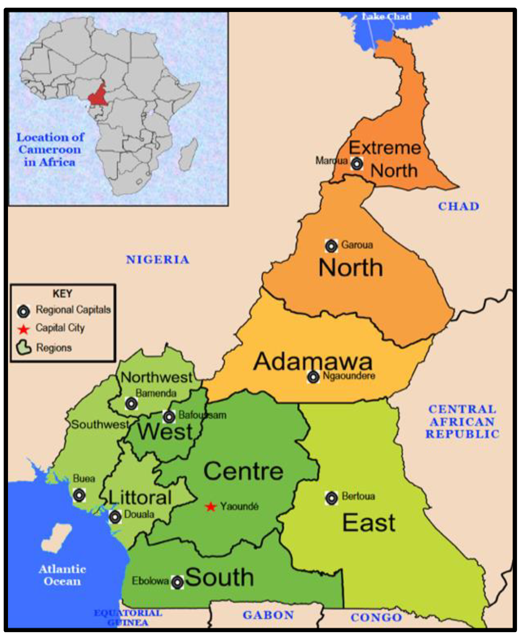
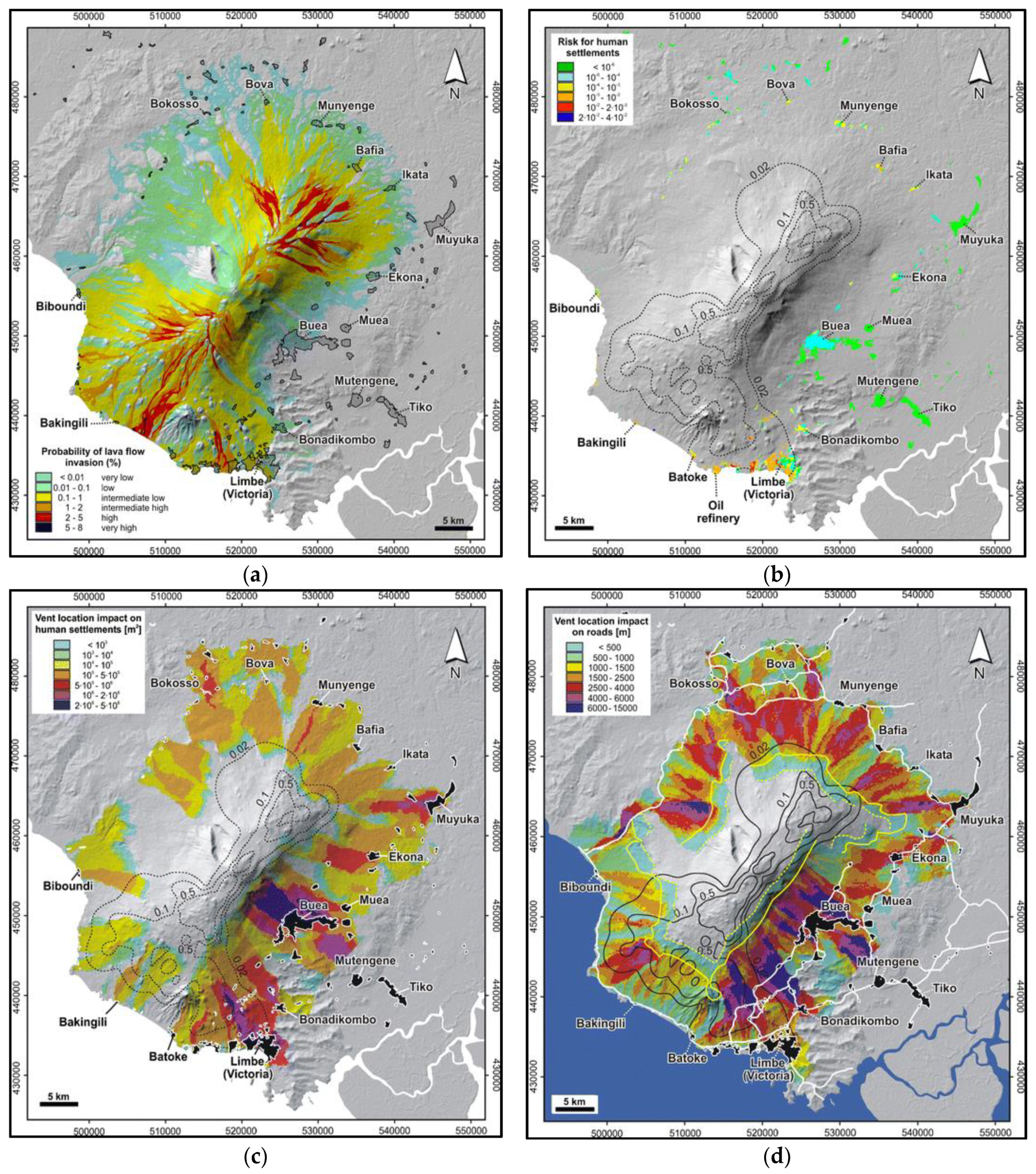
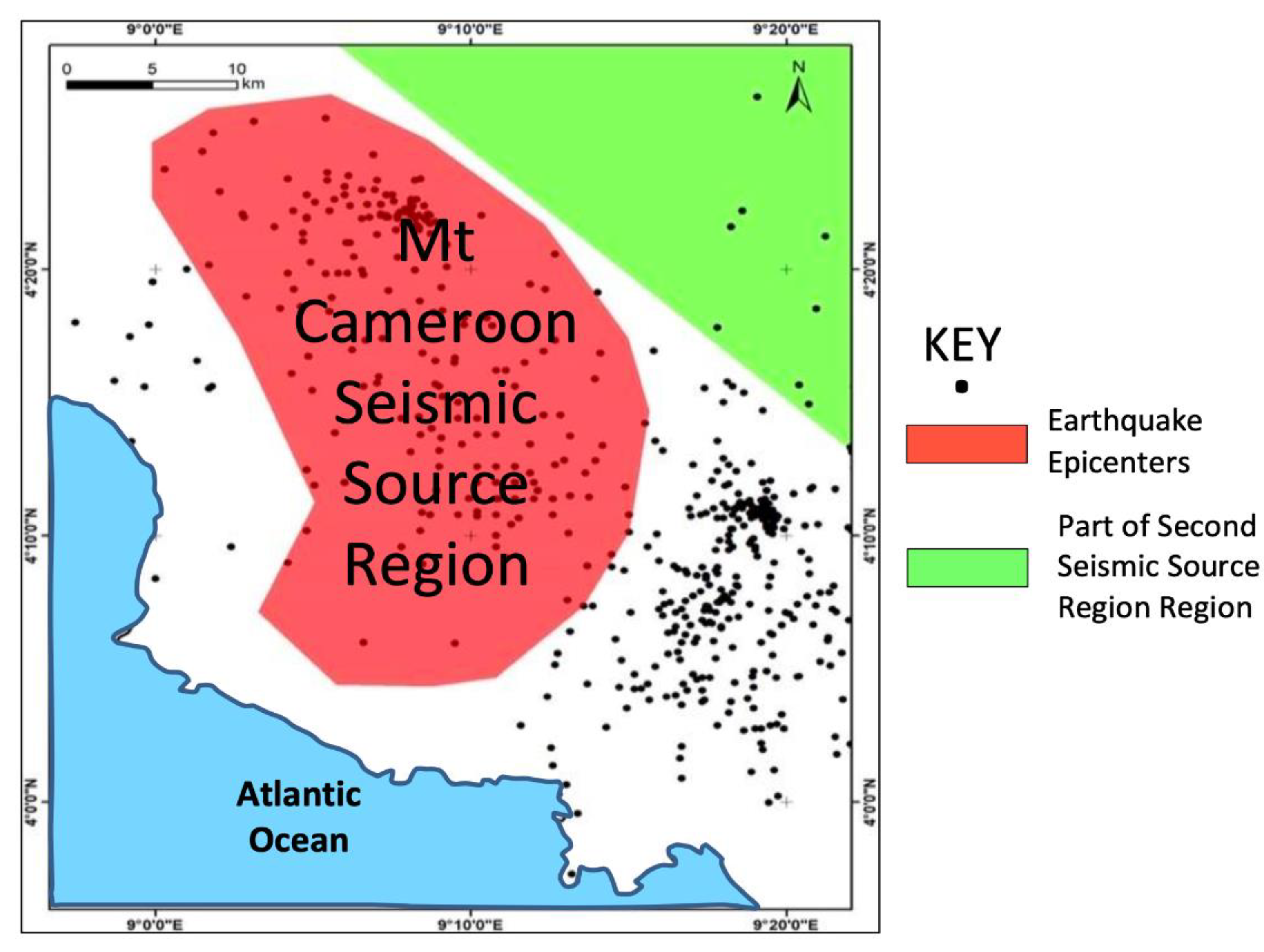
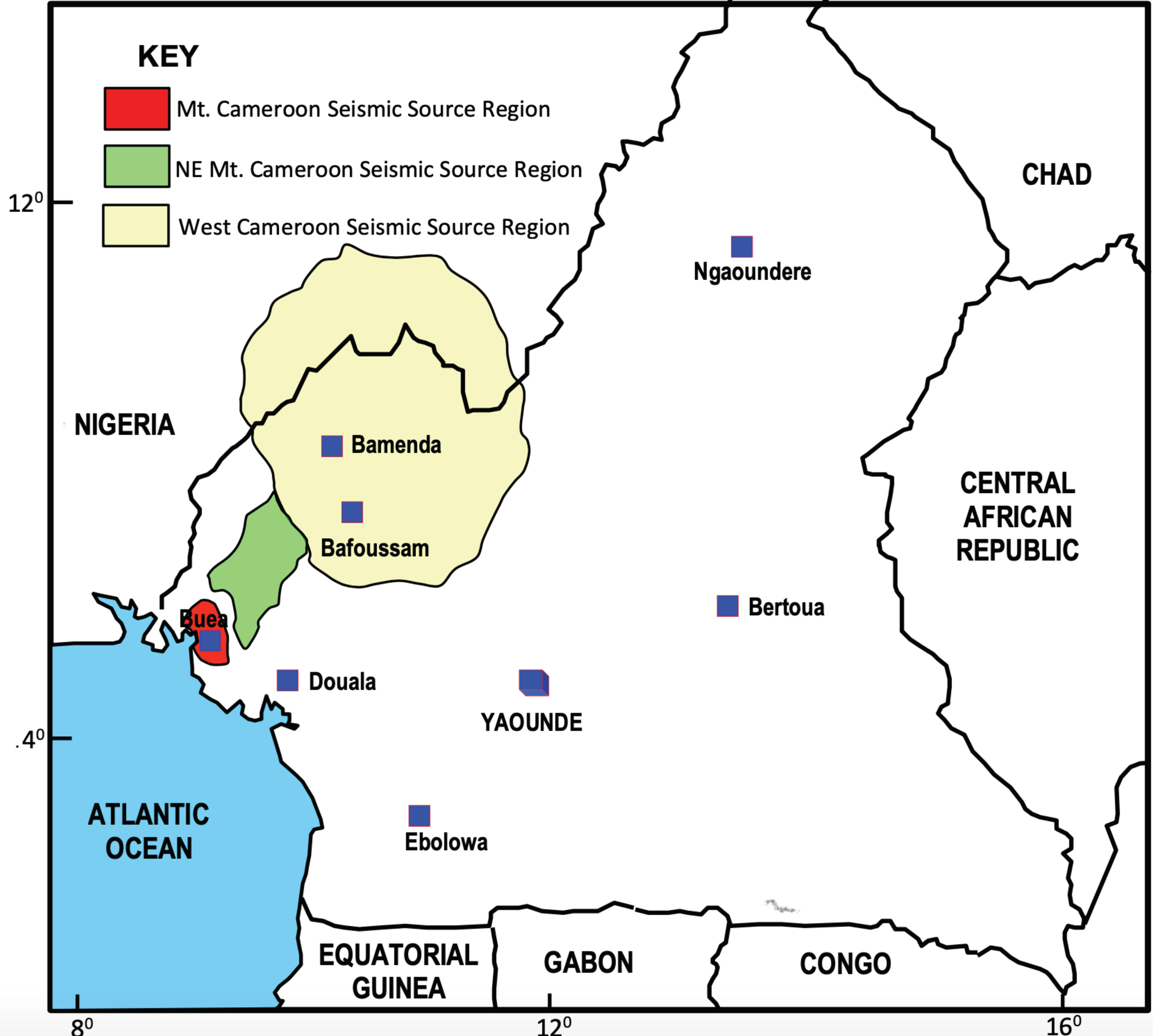
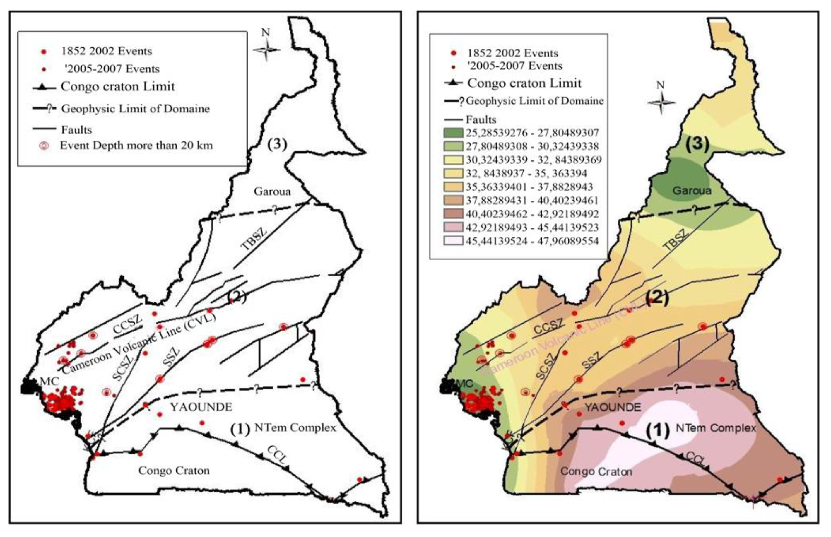
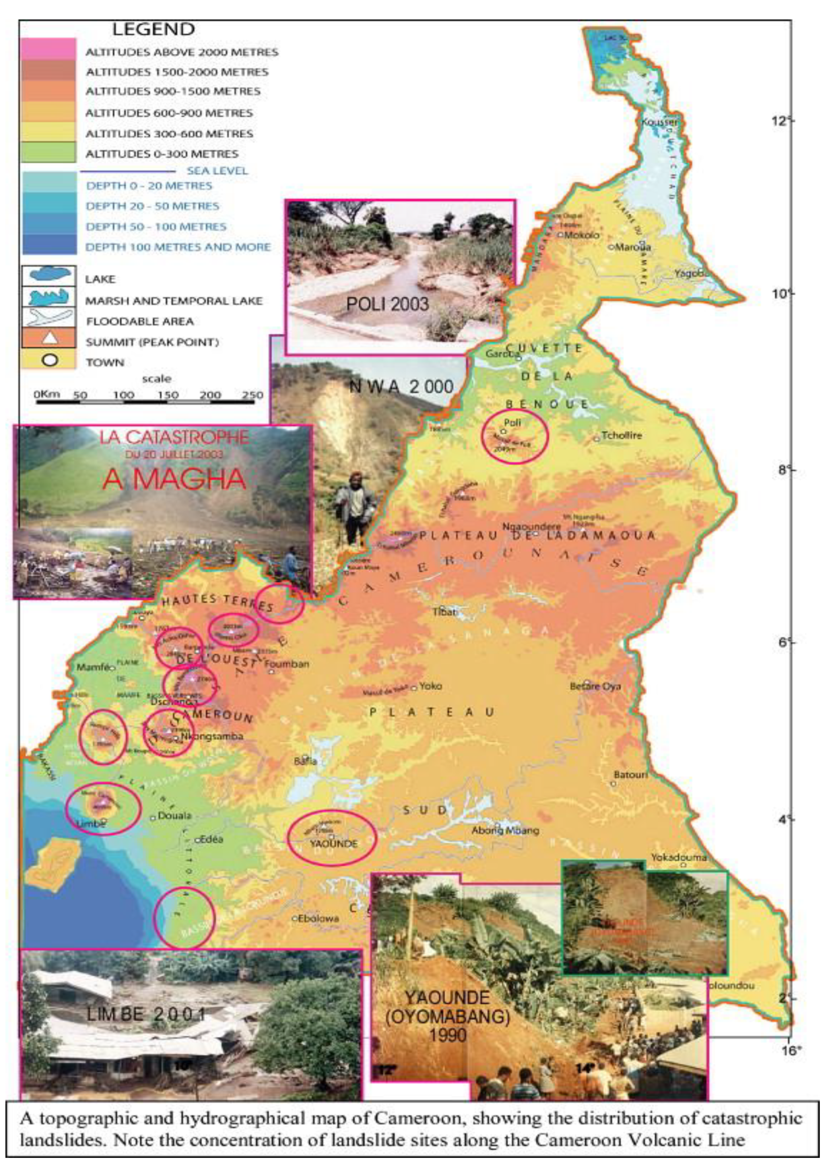
Table 1.
Main recorded earthquakes along the CVL.
| No | Year | Month | Day | Time | Longitude | Latitude | Magnitude (Mw) | Depth (Km) |
|---|---|---|---|---|---|---|---|---|
| 1 | 1907 | 11 | 16 | 21.00 | 9.600 | 4.600 | 4.8 | 0.0 |
| 2 | 1909 | 4 | 26 | 08.00 | 9.400 | 4.300 | 5.1 | 0.0 |
| 3 | 1910 | 2 | 23 | 01.00 | 9.100 | 4.200 | 4.4 | 0.0 |
| 4 | 1922 | 2 | 3 | 01.00 | 9.100 | 5.200 | 4.4 | 0.0 |
| 5 | 1969 | 1 | 24 | 03.30 | 11.100 | 5.400 | 5.2 | 0.0 |
| 6 | 1975 | 11 | 2 | 04.55 | 9.250 | 4.730 | 4.0 | 0.0 |
| 7 | 1975 | 11 | 5 | 07.17 | 9.350 | 4.650 | 3.9 | 0.0 |
| 8 | 1986 | 2 | 13 | 01.54 | 9.119 | 4.368 | 3.9 | 9.4 |
| 9 | 1990 | 9 | 20 | 12.13 | 9.070 | 4.331 | 4.2 | 9.8 |
| 10 | 1999 | 3 | 28 | 20.38 | 9.080 | 4.170 | 5.3 | 10.0 |
| 11 | 1999 | 3 | 27 | 18.04 | 9.080 | 4.170 | 5.1 | 10.0 |
| 12 | 1999 | 3 | 27 | 22.32 | 9.000 | 4.140 | 5.1 | 10.0 |
| 13 | 1999 | 3 | 28 | 20.12 | 8.850 | 3.770 | 5.1 | 10.0 |
| 14 | 1999 | 3 | 27 | 19.03 | 9.040 | 4.160 | 5.0 | 10.0 |
Source: Adapted from [66].
Table 2.
Impact of drought on people and the environment in North Cameroon.
| Region/Locality | Dates | Human Damage | Environmental Damage |
|---|---|---|---|
| Waza | September 1982 | Disappearance of animal species | |
| Mayo-Sava | 3 August 1984 | Arid and barren plain | |
| North | 15 June 1985 | Food shortage | |
| Garoua | 21 August 1985 | Ravaged green environment, insect appearance | |
| Maroua | 15 February 1991 | Poor harvest, reduced peanut and cowpea production | |
| Kousseri | 6 June 1991 | Cholera epidemic | Poor water quality |
| Extreme North | 27 February 1992 | Meningitis epidemic | |
| Adamaoua | 13 July 1985 | Degradation of pastures and drying up of tides | |
| Extreme North | 25 July 1985 | Food shortage | |
| Logone and Chari | 12 May 1987 | Food shortage | |
| Mora | 12 May 1987 | Shortage of drinking water | |
| Vina | 12 May 1987 | Shortage of drinking water | |
| Logone and Chari | 18 August 1998 | Destruction of crops, famine. | |
| Maroua | 20 January 1987 | Water shortage, locust invasion | |
| Kaélé | 12 December 1987 | Famine | Environmental deterioration. |
| Kouseri | 2000 |
Source: [102].
Table 3.
Some prominent maritime accidents in Cameroon since 2008.
| Date | Company/Incident | Location | Effects |
|---|---|---|---|
| 1 March 2013 | Collision of M/V EM Chios at the channel entrance to the port of Douala with the pilot on-board, with M/V Swift Split which was at anchorage off the access channel to the port in the south without any crew on-board. | Douala Port | Both ships were seriously damaged. |
| December 2008 | Boat capsized | Cameroon coast | 35 fatalities |
| 5 February 2015 | Collision between M/T Marida Mellisa (Oil tanker) and M/V Nord Barcelona (Oil carrier) | Douala Port | Both ships were seriously damaged |
| 16 July 2017 | Army vessel capsized | Bakassi Coast | 34 fatalities (Soldiers) |
| On 9 November 2018 | Collision between M/T Weymouth (Tanker)and M/V Teos (multipurpose vessel) | Douala Port | Both ships seriously damaged. Kerosene jet escaped and polluted the sea. |
| 25/26 August 2019 | Ferry carrying around 200 people | Bakassi Coast | 17 fatalities |
Source: Author, compiled from casualty investigation report conducted by the Cameroon Maritime Administration on March 07, 2013 and February 16, 2015; and [125].
Table 4.
Airplane crashes and accidents in Cameroon from 1947 to 2021.
| Date | Operator/Airline &/or Plane | Crash Location | Passengers/Deaths |
|---|---|---|---|
| 1 July 1947 | Air France /Junkers JU-52/3 m | Near Eaeka | 13/13 |
| 19 February 1952 | STAAP/Consolidated 32 Liberator II | Near Yaoundé | 9/9 |
| 18 April 1955 | Union des Transportes Aeriens de Havilland/DH-114 Heron 1B | Mount Kupe | 14 /12 |
| 3 June 1955 | Union Aéromaritime de Transport/ Douglas C-54A | Fort Lamy | 3/3 |
| 10 September 1955 | Societe France/HydroLatecoere 631 | Near Banyo | 16/16 |
| 13 June 1961 | Air Cameroon/Douglas C-54 Skymaster | Douala | 5/5 |
| 4 March 1962 | Caledonian Airways/Douglas DC-7C | Douala | 111/111 |
| 3 May 1963 | Air Afrique/Douglas DC-6B | Near Buca | 55/55 |
| 25 November 1963 | Cameroon Air Force/Max Holste M.H. 1521 M Broussard | Balessing (West Region) | NA/0 |
| 21 July 1964 | Air Congo/Beechcraft C-45 Expeditor | Mt. Cameroon | NA/3 |
| 3 February 1965 | Air Cameroon/Curtiss C-46A | Garoua | 4/4 |
| 11 October 1966 | Canadair/C-4M2 North Star | Near Garoua | NA/0 |
| 20 January 1966 | Central African Air Force/Douglas C-47 Skytrain | Near Yaoundé | NA/3 |
| 30 June 1967 | Air Cameroon/Douglas DC-3 | Dschang | NA/0 |
| 21 January 1967 | Cameroon Air Transport/De Havilland DH.104 Dove 1 | Tiko | NA/0 |
| 31 October 1981 | Cameroon Airlines/Canada DHC-6 Twin Otter 300 | Bafoussam | 24/1 |
| 30 August 1984 | Cameroon Airlines/Boeing B-737-2H7C | Douala | 116 /2 |
| 5 February 1987 | Aero France/Learjet 55 | Near Jakiri | 11 |
| 28 June 1989 | Cameroon Airlines/Hawker Siddeley HS-748-435 Srs. 2 | Yaoundé | 47/3 |
| 3 December 1995 | Cameroon Airlines/Boeing B-737-2K9 | Near Douala | 78/72 |
| 23 April 2006 | Lybian Arab Air Force/Antonov AN-74TK-200 | Kousséri | 6/6 |
| 5 May 2007 | Kenya Airways/Boeing B-737-8AL | Mbanga Pongo | 114/114 |
| 19 June 2010 | Aero Service/Aviocar CASA 212 | Yangadou | 11/11 |
| 10 March 2019 | Camair Co/Xian MA-60 | Bafoussam | NA |
| 1 December 2019 | Camair Co/Xian MA-60 | Bamenda | NA |
| 2 August 2020 | Cameroon Air Force/C-130 Hercules | Maroua | NA/0 |
| 21 May 2021 | Camair Co/Embraer ERJ-145 | Yaoundé | 31/0 |
Table 5.
Some prominent commercial fire incidents in Cameroon from 2010 to 2021.
| Company/Incident | Location | Effects | Date |
|---|---|---|---|
| Tiko market | Tiko, South West Region. | Around 800 shops burned to ashes. | 2 March 2010 |
| Cameroonian beauty products manufacturer (BIOPHARMA), | Douala | Warehouse destroyed | 2 November 2018 |
| National Oil Refining Company (SONARA) | Limbe | Around 70.769.400 litres of stock-fuel consumed. | 31 May 2019 |
| Cosmetic producing company (Nouvellle Parfumerie Gandour) | Douala | Warehouse, administrative & perfumeries blocks razed. | 2 March 2013 |
| Cameroon’s parliament building | Yaoundé | Four floors burnt | 16 November 2017 |
| Congo Market | Douala | More than 100 shops destroyed | 24 February 2019 |
| Schools and Houses | North West and South West Regions | Several schools and hundreds of houses burnt | June–August 2017 |
| Mboppi Market | Douala | Several shops destroyed | 22 September 2019: 1 April 2021. |
| Cité des palmiers market | Douala | More than 50 shops, stalls and merchant counters burned. | 23/24 November 2019 |
| Cameroon’s Military Academy (EMIA) | Yaoundé | Some domitaries destroyed. | 18 June 2019 |
| Bamenda food market | Bamenda | More than 200 stores destroyed | 29 November 2018 |
| Chollire District Hospital | North Region | Part of hospital destroyed | 7 November 2020 |
| New-Bell Central Prison | Douala | Rooms/property destroyed | May 28 2020 |
| Kousseri market | Kousseri (Far North Region) | Several stores/goods destroyed. | 22 March 2021 |
| Garoua market | Garoua | Several stores/goods destroyed | 20 March 2021 |
| Limbe market | Limbe | Fifty shops destroyed | 3 April 2017 |
Publisher’s Note: MDPI stays neutral with regard to jurisdictional claims in published maps and institutional affiliations. |
© 2022 by the author. Licensee MDPI, Basel, Switzerland. This article is an open access article distributed under the terms and conditions of the Creative Commons Attribution (CC BY) license (https://creativecommons.org/licenses/by/4.0/).
Share and Cite
MDPI and ACS Style
Bang, H.N. A Concise Appraisal of Cameroon’s Hazard Risk Profile: Multi-Hazard Inventories, Causes, Consequences and Implications for Disaster Management. GeoHazards 2022, 3, 55-87. https://doi.org/10.3390/geohazards3010004
AMA Style
Bang HN. A Concise Appraisal of Cameroon’s Hazard Risk Profile: Multi-Hazard Inventories, Causes, Consequences and Implications for Disaster Management. GeoHazards. 2022; 3(1):55-87. https://doi.org/10.3390/geohazards3010004
Chicago/Turabian StyleBang, Henry Ngenyam. 2022. "A Concise Appraisal of Cameroon’s Hazard Risk Profile: Multi-Hazard Inventories, Causes, Consequences and Implications for Disaster Management" GeoHazards 3, no. 1: 55-87. https://doi.org/10.3390/geohazards3010004