sensors-logo

Journal Browser

Journal Browser

Navigation Systems and Sensors

A topical collection in Sensors (ISSN 1424-8220). This collection belongs to the section "Navigation and Positioning".

Viewed by 25678

Editor


E-Mail Website
Collection Editor
Department of Geodesy, Faculty of Civil and Environmental Engineering, Gdansk Technical University, Narutowicza St. 11/12, Gdansk, Poland
Interests: radar navigation; comparative (terrain-based) navigation; multi-sensor data fusion; radar and sonar target tracking; sonar imaging and understanding; MBES bathymetry; ASV; artificial neural networks; geoinformatics
Special Issues, Collections and Topics in MDPI journals

Topical Collection Information

Dear Colleagues,

Navigation is an integral part of human activity in all environments. The variety of applications for navigation systems is relevant to human activities in space, air, land, water, underwater, and inside buildings and structures. In recent years, autonomous navigation systems for vehicles moving in any environment have been intensively developed. These systems increasingly use methods of artificial intelligence including deep learning. Intensively developed sensors such as radar, sonar, LiDAR, cameras, magnetometers, gravimeters and others provide necessary navigation data also in the process of multisensory data fusion. Navigation systems based on remote sensing are increasingly used also for navigation without GNSS including inside objects. Artificial intelligence, autonomous navigation and sensor fusion are very important topics undertaken by the most serious research centers in the world. In this topical collection, we will collect articles on many aspects of advanced navigation problems, mainly implemented with sensors, including applications of artificial intelligence methods to navigation, multisensory data fusion, comparative navigation, non-GNNS navigation, SLAM, and other topics related to navigation systems and sensors. Topics in this TC include, but are not limited to, the following keywords:

  • Artificial Intelligence for navigation and remote sensors data processing.
  • Deep learning algorithms for navigation.
  • Multisensory data fusion for navigation.
  • Big data processing for navigation.
  • Autonomous navigation.
  • SLAM (simultaneous localization and mapping).
  • Comparative (terrain reference) navigation.
  • Space and satellite navigation.
  • Aerial, surface and underwater navigation.
  • Non GNSS autonomous navigation.
  • Sensor data processing, data reduction, feature extraction, and image understanding for autonomous navigation.
  • Path-planning methods for autonomous navigation.
  • Automatic target and obstacle detection and classification for autonomous navigation.
  • Target tracking and anti-collision algorithms and methods for autonomous navigation.

Prof. Dr. Andrzej Stateczny
Collection Editor

Manuscript Submission Information

Manuscripts should be submitted online at www.mdpi.com by registering and logging in to this website. Once you are registered, click here to go to the submission form. Manuscripts can be submitted until the deadline. All submissions that pass pre-check are peer-reviewed. Accepted papers will be published continuously in the journal (as soon as accepted) and will be listed together on the collection website. Research articles, review articles as well as short communications are invited. For planned papers, a title and short abstract (about 100 words) can be sent to the Editorial Office for announcement on this website.

Submitted manuscripts should not have been published previously, nor be under consideration for publication elsewhere (except conference proceedings papers). All manuscripts are thoroughly refereed through a single-blind peer-review process. A guide for authors and other relevant information for submission of manuscripts is available on the Instructions for Authors page. Sensors is an international peer-reviewed open access semimonthly journal published by MDPI.

Please visit the Instructions for Authors page before submitting a manuscript. The Article Processing Charge (APC) for publication in this open access journal is 2600 CHF (Swiss Francs). Submitted papers should be well formatted and use good English. Authors may use MDPI's English editing service prior to publication or during author revisions.

Keywords

  • Artificial Intelligence for navigation and remote sensors data processing
  • Deep learning algorithms for navigation
  • Multisensory data fusion for navigation
  • Big data processing for navigation
  • Autonomous navigation
  • SLAM (simultaneous localization and mapping).
  • Comparative (terrain reference) navigation
  • Space and satellite navigation
  • Aerial, surface and underwater navigation
  • Non GNSS autonomous navigation
  • Sensor data processing, data reduction, feature extraction, and image understanding for autonomous navigation
  • Path-planning methods for autonomous navigation
  • Automatic target and obstacle detection and classification for autonomous navigation
  • Target tracking and anti-collision algorithms and methods for autonomous navigation

Published Papers (15 papers)

2024

Jump to: 2023, 2022

15 pages, 8736 KiB  
Article
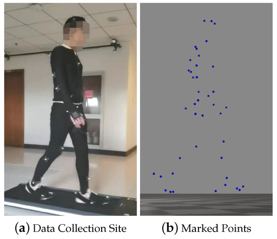
Data Fusion of Dual Foot-Mounted INS Based on Human Step Length Model
by Jianqiang Chen, Gang Liu and Meifeng Guo
Sensors 2024, 24(4), 1073; https://doi.org/10.3390/s24041073 - 07 Feb 2024
Viewed by 506
Abstract
Pedestrian navigation methods based on inertial sensors are commonly used to solve navigation and positioning problems when satellite signals are unavailable. To address the issue of heading angle errors accumulating over time in pedestrian navigation systems that rely solely on the Zero Velocity [...] Read more.
Pedestrian navigation methods based on inertial sensors are commonly used to solve navigation and positioning problems when satellite signals are unavailable. To address the issue of heading angle errors accumulating over time in pedestrian navigation systems that rely solely on the Zero Velocity Update (ZUPT) algorithm, it is feasible to use the pedestrian’s motion constraints to constrain the errors. Firstly, a human step length model is built using human kinematic data collected by the motion capture system. Secondly, we propose the bipedal constraint algorithm based on the established human step length model. Real field experiments demonstrate that, by introducing the bipedal constraint algorithm, the mean biped radial errors of the experiments are reduced by 68.16% and 50.61%, respectively. The experimental results show that the proposed algorithm effectively reduces the radial error of the navigation results and improves the accuracy of the navigation. Full article
Show Figures

Figure 1

17 pages, 19910 KiB  
Article
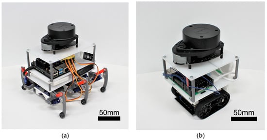
The Influence of Micro-Hexapod Walking-Induced Pose Changes on LiDAR-SLAM Mapping Performance
by Hiroshi Seki, Yuhi Yamamoto and Sumito Nagasawa
Sensors 2024, 24(2), 639; https://doi.org/10.3390/s24020639 - 19 Jan 2024
Viewed by 644
Abstract
Micro-hexapods, well-suited for navigating tight or uneven spaces and suitable for mass production, hold promise for exploration by robot groups, particularly in disaster scenarios. However, research on simultaneous localization and mapping (SLAM) for micro-hexapods has been lacking. Previous studies have not adequately addressed [...] Read more.
Micro-hexapods, well-suited for navigating tight or uneven spaces and suitable for mass production, hold promise for exploration by robot groups, particularly in disaster scenarios. However, research on simultaneous localization and mapping (SLAM) for micro-hexapods has been lacking. Previous studies have not adequately addressed the development of SLAM systems considering changes in the body axis, and there is a lack of comparative evaluation with other movement mechanisms. This study aims to assess the influence of walking on SLAM capabilities in hexapod robots. Experiments were conducted using the same SLAM system and LiDAR on both a hexapod robot and crawler robot. The study compares map accuracy and LiDAR point cloud data through pattern matching. The experimental results reveal significant fluctuations in LiDAR point cloud data in hexapod robots due to changes in the body axis, leading to a decrease in map accuracy. In the future, the development of SLAM systems considering body axis changes is expected to be crucial for multi-legged robots like micro-hexapods. Therefore, we propose the implementation of a system that incorporates body axis changes during locomotion using inertial measurement units and similar sensors. Full article
Show Figures

Figure 1

23 pages, 1912 KiB  
Article
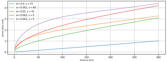
Prediction of Ground Wave Propagation Delay for MF R-Mode
by Niklas Hehenkamp, Filippo Giacomo Rizzi, Lars Grundhöfer and Stefan Gewies
Sensors 2024, 24(1), 282; https://doi.org/10.3390/s24010282 - 03 Jan 2024
Viewed by 763
Abstract
Time delays caused by ground wave propagation are the primary source of systematic error limiting the performance of the medium-frequency R-Mode radionavigation system. To achieve the desired ranging accuracy and compensate these delays, we have conceived a comprehensive correction scheme based on the [...] Read more.
Time delays caused by ground wave propagation are the primary source of systematic error limiting the performance of the medium-frequency R-Mode radionavigation system. To achieve the desired ranging accuracy and compensate these delays, we have conceived a comprehensive correction scheme based on the prediction and application of the Atmospheric and Ground wave Delay Factor (AGDF). The AGDF was computed and mapped in 2D for a number of MF R-Mode transmitters in the Baltic Sea that were embedded into the receiver and evaluated during a large-scale measurement campaign. Our results show that the proposed AGDF approach is valid for the MF R-Mode system and provides accurate corrections of ground wave propagation delays within the performance requirements. Full article
Show Figures

Figure 1

2023

Jump to: 2024, 2022

16 pages, 1428 KiB  
Article
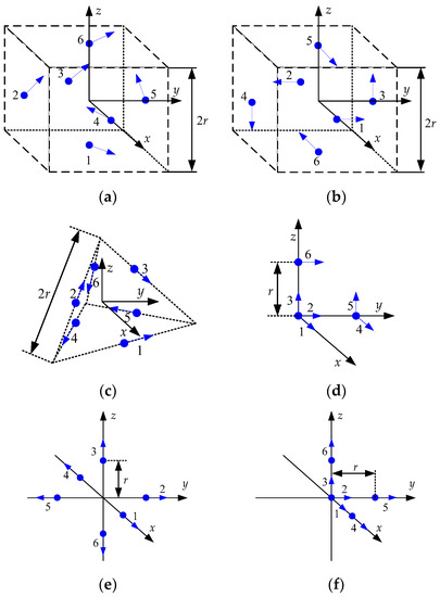
Note on Coarse Alignment of Gyro-Free Inertial Navigation System
by Heyone Kim, Jae-Hoon Son, Sang-Heon Oh and Dong-Hwan Hwang
Sensors 2023, 23(12), 5763; https://doi.org/10.3390/s23125763 - 20 Jun 2023
Viewed by 813
Abstract
In this note, the feasibility of initial alignment of a gyro-free inertial navigation system (GF-INS) is investigated. Initial roll and initial pitch are obtained using leveling of conventional INS since centripetal acceleration is very small. The equation for the initial heading cannot be [...] Read more.
In this note, the feasibility of initial alignment of a gyro-free inertial navigation system (GF-INS) is investigated. Initial roll and initial pitch are obtained using leveling of conventional INS since centripetal acceleration is very small. The equation for the initial heading cannot be used since the GF inertial measurement unit (IMU) cannot directly measure the Earth rate. A new equation is derived to obtain the initial heading from GF-IMU accelerometer outputs. Initial heading is expressed in the accelerometer outputs of two configurations, which satisfies a specific condition among 15 GF-IMU configurations presented in the literature. The initial heading error to arrangement and accelerometer error is quantitatively analyzed from the initial heading calculation equation of GF-INS and the initial heading error analysis of the general INS. The initial heading error is investigated when gyroscopes are used with GF-IMU. The results show that the initial heading error depends more on the performance of the gyroscope than that of the accelerometer, and the initial heading cannot be obtained within a practical error level by using only GF-IMU, even when an extremely accurate accelerometer is used. Therefore, aiding sensors have to be used in order to have a practical initial heading. Full article
Show Figures

Figure 1

21 pages, 2371 KiB  
Review
Review of Shoreline Extraction Methods from Aerial Laser Scanning
by Andrzej Stateczny, Armin Halicki, Mariusz Specht, Cezary Specht and Oktawia Lewicka
Sensors 2023, 23(11), 5331; https://doi.org/10.3390/s23115331 - 04 Jun 2023
Cited by 1 | Viewed by 1408
Abstract
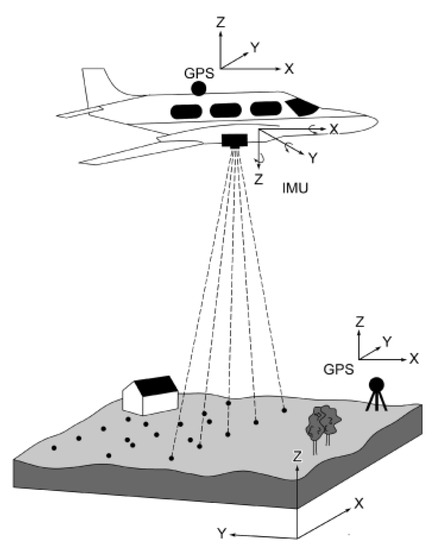
Autonomous technologies are increasingly used in various areas of science. The use of unmanned vehicles for hydrographic surveys in shallow coastal areas requires accurate estimation of shoreline position. This is a nontrivial task, which can be performed using a wide range of sensors [...] Read more.
Autonomous technologies are increasingly used in various areas of science. The use of unmanned vehicles for hydrographic surveys in shallow coastal areas requires accurate estimation of shoreline position. This is a nontrivial task, which can be performed using a wide range of sensors and methods. The aim of the publication is to review shoreline extraction methods based solely on data from aerial laser scanning (ALS). This narrative review discusses and critically analyses seven publications drawn up in the last ten years. The discussed papers employed nine different shoreline extraction methods based on aerial light detection and ranging (LiDAR) data. It should be noted that unambiguous evaluation of shoreline extraction methods is difficult or impossible. This is because not all of the methods reported achieved accuracy, the methods were assessed on different datasets, the measurements were conducted using different devices, the water areas differed in geometrical and optical properties, the shorelines had different geometries, and the extent of anthropogenic transformation. The methods proposed by the authors were compared with a wide range of reference methods. Full article
Show Figures

Figure 1

2022

Jump to: 2024, 2023

28 pages, 16927 KiB  
Article
Analysis and Accuracy Improvement of UWB-TDoA-Based Indoor Positioning System
by Paolo Grasso, Mauro S. Innocente, Jun Jet Tai, Olivier Haas and Arash M. Dizqah
Sensors 2022, 22(23), 9136; https://doi.org/10.3390/s22239136 - 24 Nov 2022
Cited by 7 | Viewed by 2459
Abstract
Positioning systems are used in a wide range of applications which require determining the position of an object in space, such as locating and tracking assets, people and goods; assisting navigation systems; and mapping. Indoor Positioning Systems (IPSs) are used where satellite and [...] Read more.
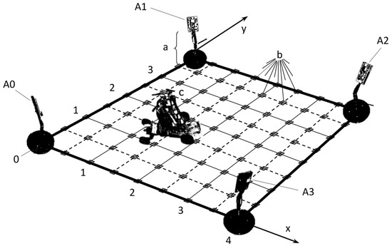
Positioning systems are used in a wide range of applications which require determining the position of an object in space, such as locating and tracking assets, people and goods; assisting navigation systems; and mapping. Indoor Positioning Systems (IPSs) are used where satellite and other outdoor positioning technologies lack precision or fail. Ultra-WideBand (UWB) technology is especially suitable for an IPS, as it operates under high data transfer rates over short distances and at low power densities, although signals tend to be disrupted by various objects. This paper presents a comprehensive study of the precision, failure, and accuracy of 2D IPSs based on UWB technology and a pseudo-range multilateration algorithm using Time Difference of Arrival (TDoA) signals. As a case study, the positioning of a 4×4m2 area, four anchors (transceivers), and one tag (receiver) are considered using bitcraze’s Loco Positioning System. A Cramér–Rao Lower Bound analysis identifies the convex hull of the anchors as the region with highest precision, taking into account the anisotropic radiation pattern of the anchors’ antennas as opposed to ideal signal distributions, while bifurcation envelopes containing the anchors are defined to bound the regions in which the IPS is predicted to fail. This allows the formulation of a so-called flyable area, defined as the intersection between the convex hull and the region outside the bifurcation envelopes. Finally, the static bias is measured after applying a built-in Extended Kalman Filter (EKF) and mapped using a Radial Basis Function Network (RBFN). A debiasing filter is then developed to improve the accuracy. Findings and developments are experimentally validated, with the IPS observed to fail near the anchors, precision around ±3cm, and accuracy improved by about 15cm for static and 5cm for dynamic measurements, on average. Full article
Show Figures

Figure 1

17 pages, 15925 KiB  
Article
Efficient Informative Path Planning via Normalized Utility in Unknown Environments Exploration
by Tianyou Yu, Baosong Deng, Jianjun Gui, Xiaozhou Zhu and Wen Yao
Sensors 2022, 22(21), 8429; https://doi.org/10.3390/s22218429 - 02 Nov 2022
Cited by 4 | Viewed by 1714
Abstract
Exploration is an important aspect of autonomous robotics, whether it is for target searching, rescue missions, or reconnaissance in an unknown environment. In this paper, we propose a solution to efficiently explore the unknown environment by unmanned aerial vehicles (UAV). Innovatively, a topological [...] Read more.
Exploration is an important aspect of autonomous robotics, whether it is for target searching, rescue missions, or reconnaissance in an unknown environment. In this paper, we propose a solution to efficiently explore the unknown environment by unmanned aerial vehicles (UAV). Innovatively, a topological road map is incrementally built based on Rapidly-exploring Random Tree (RRT) and maintained along with the whole exploration process. The topological structure can provide a set of waypoints for searching an optimal informative path. To evaluate the path, we consider the information measurement based on prior map uncertainty and the distance cost of the path, and formulate a normalized utility to describe information-richness along the path. The informative path is determined in every period by a local planner, and the robot executes the planned path to collect measurements of the unknown environment and restructure a map. The proposed framework and its composed modules are verified in two 3-D environments, which exhibit better performance in improving the exploration efficiency than other methods. Full article
Show Figures

Figure 1

18 pages, 9277 KiB  
Article
Application of Continuous Wavelet Transform and Artificial Naural Network for Automatic Radar Signal Recognition
by Marta Walenczykowska and Adam Kawalec
Sensors 2022, 22(19), 7434; https://doi.org/10.3390/s22197434 - 30 Sep 2022
Cited by 5 | Viewed by 2007
Abstract
This article aims to propose an algorithm for the automatic recognition of selected radar signals. The algorithm can find application in areas such as Electronic Warfare (EW), where automatic recognition of the type of intra-pulse modulation or the type of emitter operation mode [...] Read more.
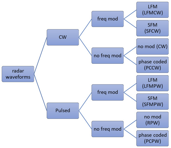
This article aims to propose an algorithm for the automatic recognition of selected radar signals. The algorithm can find application in areas such as Electronic Warfare (EW), where automatic recognition of the type of intra-pulse modulation or the type of emitter operation mode can aid the decision-making process. The simulations carried out included the analysis of the classification possibilities of linear frequency modulated pulsed waveform (LFMPW), stepped frequency modulated pulsed waveform (SFMPW), phase coded pulsed waveform (PCPW), rectangular pulsed waveforms (RPW), frequency modulated continuous wave (FMCW), continuous wave (CW), Stepped Frequency Continuous Wave SFCW) and Phase Coded Continuous Waveform (PCCW). The algorithm proposed in this paper is based on the use of continuous wavelet transform (CWT) coefficients and higher-order statistics (HOS) in the feature determination of selected signals. The Principal Component Analysis (PCA) method was used for dimensionality reduction. An artificial neural network was then used as a classifier. Simulation studies took into account the presence of noise interference with signal-to-noise ratio (SNR) in the range from −5 to 10 dB. Finally, the obtained classification efficiency is presented in the form of a confusion matrix. The simulation results show a high recognition test accuracy, above 99% with a signal-to-noise ratio greater than 0 dB. The article also deals with the selection of the type and parameters of the wavelet. The authors also point to the problems encountered during the research and examples of how to solve them. Full article
Show Figures

Figure 1

19 pages, 2407 KiB  
Article
The Concept of Using the Decision-Robustness Function in Integrated Navigation Systems
by Krzysztof Czaplewski and Bartosz Czaplewski
Sensors 2022, 22(16), 6157; https://doi.org/10.3390/s22166157 - 17 Aug 2022
Cited by 2 | Viewed by 1189
Abstract
The diversity and non-uniformity of the positioning systems available in maritime navigation systems often impede the watchkeeping officer in the selection of the appropriate positioning system, in particular, in restricted basins. Thus, it is necessary to introduce a mathematical apparatus to suggest, in [...] Read more.
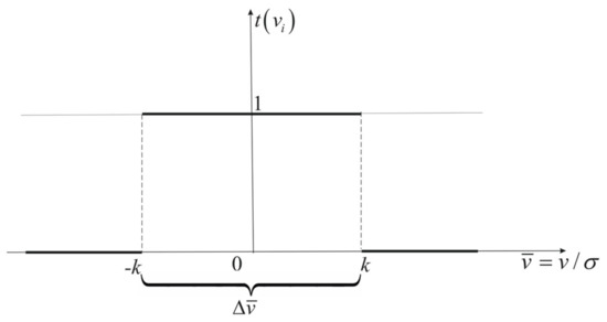
The diversity and non-uniformity of the positioning systems available in maritime navigation systems often impede the watchkeeping officer in the selection of the appropriate positioning system, in particular, in restricted basins. Thus, it is necessary to introduce a mathematical apparatus to suggest, in an automated manner, which of the available systems should be used at the given moment of a sea trip. Proper selection of the positioning system is particularly important in integrated navigation systems, in which the excess of navigation information may impede the final determinations. In this article, the authors propose the use of the decision-robustness function to assist in the process of selecting the appropriate positioning system and reduce the impact of navigation observations encumbered with large errors in self-positioning accuracy. The authors present a mathematical apparatus describing the decision function (a priori object), with the determination of decision-assistance criteria, and the robustness function (a posteriori object), with different types of attenuation function. In addition, the authors present a computer application integrating both objects in the decision-robustness function. The study was concluded by a test showing the practical application of the decision-robustness function proposed in the title. Full article
Show Figures

Figure 1

20 pages, 4798 KiB  
Article
A Wi-Fi Indoor Positioning Method Based on an Integration of EMDT and WKNN
by Rong Zhou, Fengying Meng, Jing Zhou and Jing Teng
Sensors 2022, 22(14), 5411; https://doi.org/10.3390/s22145411 - 20 Jul 2022
Cited by 6 | Viewed by 1401
Abstract
In indoor positioning, signal fluctuation is one of the main factors affecting positioning accuracy. To solve this problem, a new method based on an integration of the empirical mode decomposition threshold smoothing method (EMDT) and improved weighted K nearest neighbor (WKNN), named EMDT-WKNN, [...] Read more.
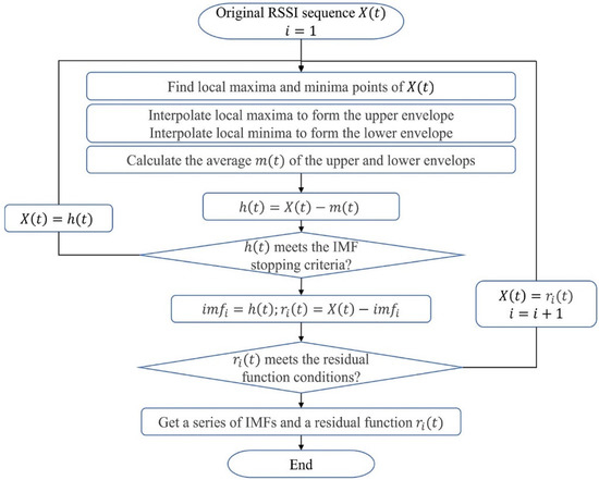
In indoor positioning, signal fluctuation is one of the main factors affecting positioning accuracy. To solve this problem, a new method based on an integration of the empirical mode decomposition threshold smoothing method (EMDT) and improved weighted K nearest neighbor (WKNN), named EMDT-WKNN, is proposed in this paper. First, the nonlinear and non-stationary received signal strength indication (RSSI) sequences are constructed. Secondly, intrinsic mode functions (IMF) selection criteria based on energy analysis method and fluctuation coefficients is proposed. Thirdly, the EMDT method is employed to smooth the RSSI fluctuation. Finally, to further avoid the influence of RSSI fluctuation on the positioning accuracy, the deviated matching points are removed, and more precise combined weights are constructed by combining the geometric distance of the matching points and the Euclidean distance of fingerprints in the positioning method-WKNN. The experimental results show that, on an underground parking dataset, the positioning accuracy based on EMDT-WKNN can reach 1.73 m in the 75th percentile positioning error, which is 27.6% better than 2.39 m of the original RSSI positioning method. Full article
Show Figures

Figure 1

19 pages, 5140 KiB  
Article
A New Self-Calibration and Compensation Method for Installation Errors of Uniaxial Rotation Module Inertial Navigation System
by Meng Niu, Hongyu Ma, Xinglin Sun, Tiantian Huang and Kaichen Song
Sensors 2022, 22(10), 3812; https://doi.org/10.3390/s22103812 - 17 May 2022
Cited by 3 | Viewed by 2106
Abstract
Calibration and compensation techniques are essential to improve the accuracy of the strap-down inertial navigation system. Especially for the new uniaxial rotation module inertial navigation system (URMINS), replacing faulty uniaxial rotation modules introduces installation errors between modules and reduces navigation accuracy. Therefore, it [...] Read more.
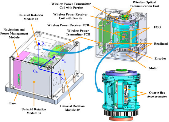
Calibration and compensation techniques are essential to improve the accuracy of the strap-down inertial navigation system. Especially for the new uniaxial rotation module inertial navigation system (URMINS), replacing faulty uniaxial rotation modules introduces installation errors between modules and reduces navigation accuracy. Therefore, it is necessary to calibrate these systems effectively and compensate for the installation error between modules. This paper proposes a new self-calibration and compensation method for installation errors without additional information and equipment. Using the attitude, velocity, and position differences between the two sets of navigation information output from URMINS as measurements, a Kalman filter is constructed and the installation error is estimated. After URMINS is compensated for the installation error, the average of the demodulated redundant information is taken to calculate the carrier’s navigation information. The simulation results show that the proposed method can effectively assess the installation error between modules with an estimation accuracy better than 5”. Experimental results for static navigation show that the accuracy of heading angle and positioning can be improved by 73.12% and 81.19% after the URMINS has compensated for the estimated installation errors. Simulation and experimental results further validate the effectiveness of the proposed self-calibration and compensation method. Full article
Show Figures

Figure 1

20 pages, 1593 KiB  
Article
LiDAR- and Radar-Based Robust Vehicle Localization with Confidence Estimation of Matching Results
by Ryo Yanase, Daichi Hirano, Mohammad Aldibaja, Keisuke Yoneda and Naoki Suganuma
Sensors 2022, 22(9), 3545; https://doi.org/10.3390/s22093545 - 06 May 2022
Cited by 8 | Viewed by 2847
Abstract
Localization is an important technology for autonomous driving. Map-matching using road surface pattern features gives accurate position estimation and has been used in autonomous driving tests on public roads. To provide highly safe autonomous driving, localization technology that is not affected by the [...] Read more.
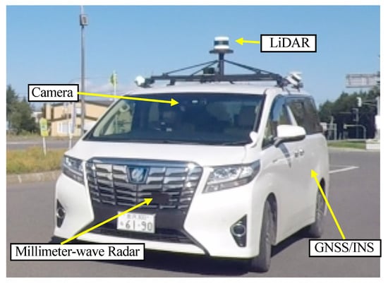
Localization is an important technology for autonomous driving. Map-matching using road surface pattern features gives accurate position estimation and has been used in autonomous driving tests on public roads. To provide highly safe autonomous driving, localization technology that is not affected by the environment is required. In particular, in snowy environments, the features of the road surface pattern may not be used for matching because the road surface is hidden. In such cases, it is necessary to construct a robust system by rejecting the matching results or making up for them with other sensors. On the other hand, millimeter-wave radar-based localization methods are not as accurate as LiDAR-based methods due to their ranging accuracy, but it has successfully achieved autonomous driving in snowy environments. Therefore, this paper proposes a localization method that combines LiDAR and millimeter-wave radar. We constructed a system that emphasizes LiDAR-based matching results during normal conditions when the road surface pattern is visible and emphasizes radar matching results when the road surface is not visible due to snow cover or other factors. This method achieves an accuracy that allows autonomous driving to continue regardless of normal or snowy conditions and more robust position estimation. Full article
Show Figures

Figure 1

28 pages, 26045 KiB  
Article
Research on an LEO Constellation Multi-Aircraft Collaborative Navigation Algorithm Based on a Dual-Way Asynchronous Precision Communication-Time Service Measurement System (DWAPC-TSM)
by Lvyang Ye, Yikang Yang, Jiangang Ma, Lingyu Deng and Hengnian Li
Sensors 2022, 22(9), 3213; https://doi.org/10.3390/s22093213 - 22 Apr 2022
Cited by 5 | Viewed by 2022
Abstract
In order to solve the collaborative navigation problems in challenging environments such as insufficient visible satellites, obstacle reflections and multipath errors, and in order to improve the accuracy, usability, and stability of collaborative navigation and positioning, we propose a dual-way asynchronous precision communication–timing–measurement [...] Read more.
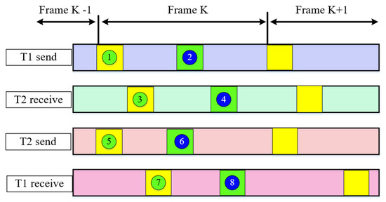
In order to solve the collaborative navigation problems in challenging environments such as insufficient visible satellites, obstacle reflections and multipath errors, and in order to improve the accuracy, usability, and stability of collaborative navigation and positioning, we propose a dual-way asynchronous precision communication–timing–measurement system (DWAPC-TSM) LEO constellation multi-aircraft cooperative navigation and positioning algorithm which gives the principle, algorithm structure, and error analysis of the DWAPC-TSM system. In addition, we also analyze the effect of vehicle separation range on satellite observability. The DWAPC-TSM system can achieve high-precision ranging and time synchronization accuracy. With the help of this system, by adding relative ranging and speed measurement observations in an unscented Kalman filter (UKF), the multi-aircraft coordinated navigation and positioning of aircraft is finally realized. The simulation results show that, even without the aid of an altimeter, the multi-aircraft cooperative navigation and positioning algorithm based on the DWAPC-TSM system can achieve good navigation and positioning results, and with the aid of the altimeter, the cooperative navigation and positioning accuracy can be effectively improved. For the formation flight configurations of horizontal collinear and vertical collinear, the algorithm is universal, and in the case of vertical collinear, the navigation performance of the formation members tends to be consistent. Under different relative measurement accuracy, the algorithm can maintain good robustness; compared with some existing classical algorithms, it can significantly improve the navigation and positioning accuracy. A reference scheme for exploring the feasibility of a new cooperative navigation and positioning mode for LEO communication satellites is presented. Full article
Show Figures

Figure 1

17 pages, 6516 KiB  
Article
Behavior of Low-Cost Receivers in Base-Rover Configuration with Geodetic-Grade Antennas
by Giannina Sanna, Tonino Pisanu and Salvatore Garau
Sensors 2022, 22(7), 2779; https://doi.org/10.3390/s22072779 - 05 Apr 2022
Cited by 3 | Viewed by 2342
Abstract
The main goal of this research was to evaluate the performances of the ZED-F9P-Ublox low-cost GNSS receiver in a base-rover real configuration. We realized a base configuration with two permanent stations based on the ZED-F9P and two geodetic antennas and the rover configuration [...] Read more.
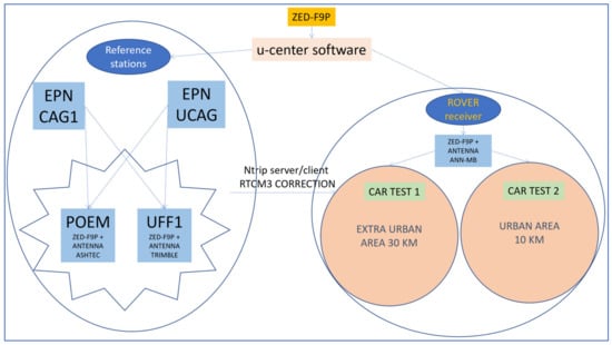
The main goal of this research was to evaluate the performances of the ZED-F9P-Ublox low-cost GNSS receiver in a base-rover real configuration. We realized a base configuration with two permanent stations based on the ZED-F9P and two geodetic antennas and the rover configuration based on another ZED-F9P and an ANN-MB-00-00 Multi-band (L1, L2/E5b/B2I) active GNSS u-blox antenna. In the calculation of the reference stations, we compared the solutions with the ZED-F9P receiver and a professional receiver. Comparison showed greater variability in the solutions, but the coordinate values were in very good agreement. Standard deviations were in the order of a few millimeters. On the rover side, two car tests were performed in two different environments, one in an extra-urban environment with a long baseline of approximately 30 km in an open sky area with varying visibility and shielded locations, the other one in an urban area around a circle approximately 10 km in diameter with the presence of buildings and open sectors. The results of the measurements were very good, with more than 95% of fixed solutions in real-time and a time to fix on reacquisition of 1 or 2 s. Moreover, real-time kinematic solutions were in good agreement with the post-processed ones, showing that less than 5% of differences were above 30 mm in the horizontal component and 100 mm in the vertical component. Full article
Show Figures

Figure 1

15 pages, 863 KiB  
Perspective
Analysis of Methods for Determining Shallow Waterbody Depths Based on Images Taken by Unmanned Aerial Vehicles
by Mariusz Specht, Marta Wiśniewska, Andrzej Stateczny, Cezary Specht, Bartosz Szostak, Oktawia Lewicka, Marcin Stateczny, Szymon Widźgowski and Armin Halicki
Sensors 2022, 22(5), 1844; https://doi.org/10.3390/s22051844 - 25 Feb 2022
Cited by 12 | Viewed by 2158
Abstract
Hydrographic surveys enable the acquisition and processing of bathymetric data, which after being plotted onto nautical charts, can help to ensure safety of navigation, monitor changes in the coastal zone, and assess hydro-engineering structure conditions. This study involves the measurement of waterbody depth, [...] Read more.
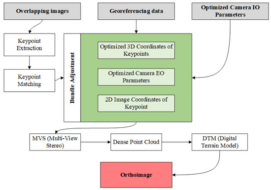
Hydrographic surveys enable the acquisition and processing of bathymetric data, which after being plotted onto nautical charts, can help to ensure safety of navigation, monitor changes in the coastal zone, and assess hydro-engineering structure conditions. This study involves the measurement of waterbody depth, identification of the seabed shape and geomorphology, the coastline course, and the location of underwater obstacles. Hydroacoustic systems mounted on vessels are commonly used in bathymetric measurements. However, there is also an increasing use of Unmanned Aerial Vehicles (UAV) that can employ sensors such as LiDAR (Light Detection And Ranging) or cameras previously not applied in hydrography. Current systems based on photogrammetric and remote sensing methods enable the determination of shallow waterbody depth with no human intervention and, thus, significantly reduce the duration of measurements, especially when surveying large waterbodies. The aim of this publication is to present and compare methods for determining shallow waterbody depths based on an analysis of images taken by UAVs. The perspective demonstrates that photogrammetric techniques based on the SfM (Structure-from-Motion) and MVS (Multi-View Stereo) method allow high accuracies of depth measurements to be obtained. Errors due to the phenomenon of water-wave refraction remain the main limitation of these techniques. It was also proven that image processing based on the SfM-MVS method can be effectively combined with other measurement methods that enable the experimental determination of the parameters of signal propagation in water. The publication also points out that the Lyzenga, Satellite-Derived Bathymetry (SDB), and Stumpf methods allow satisfactory depth measurement results to be obtained. However, they require further testing, as do methods using the optical wave propagation properties. Full article
Show Figures

Figure 1

Back to TopTop