Generating Daily Soil Moisture at 16 m Spatial Resolution Using a Spatiotemporal Fusion Model and Modified Perpendicular Drought Index
Abstract
:1. Introduction
2. Materials and Methods
2.1. Study Area
2.2. Datasets and Preprocessing
2.2.1. GF and MODIS Reflectance
2.2.2. ESA CCI SM
2.2.3. In Situ SM Data
2.3. Downscaling Approaches
2.3.1. Research Flowchart
2.3.2. Core Algorithms
ESTARFM
Spatially Downscaling Model Constructed by SSCF
2.3.3. Evaluation Methods
3. Results
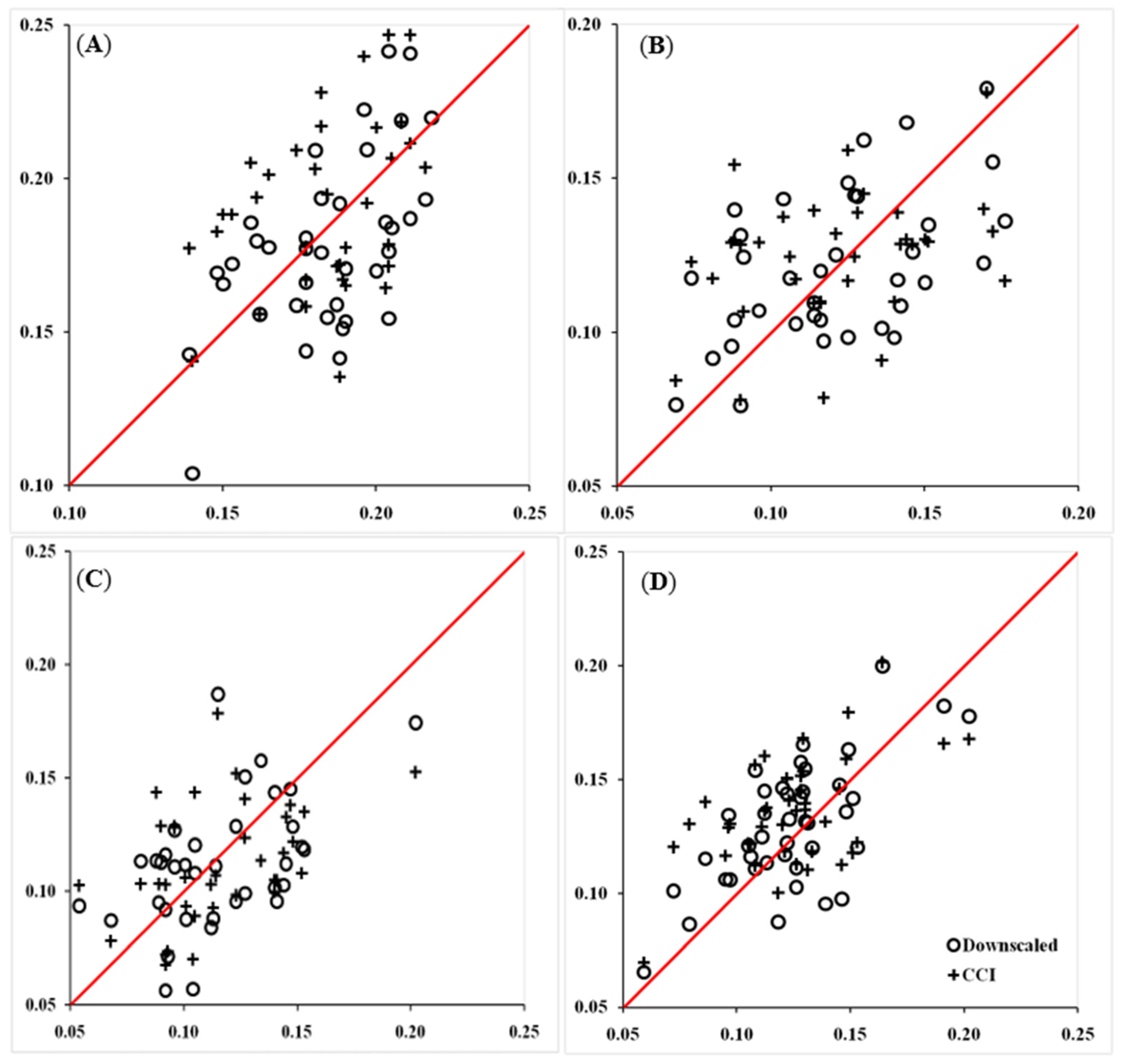
3.1. Comparison of Downscaled CCI SM Data with In Situ Observations
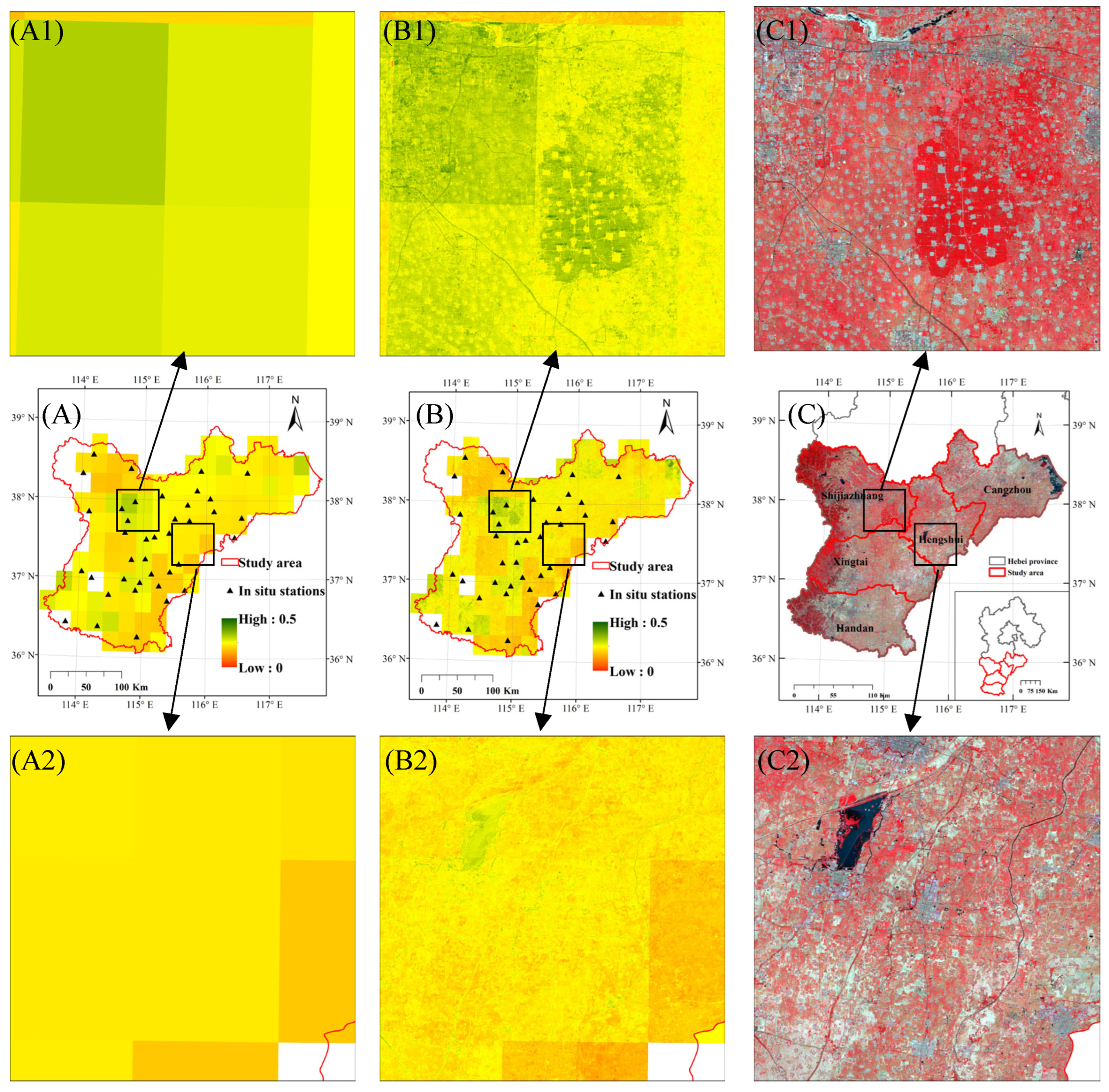
3.2. Visual Comparison of the Downscaled CCI SM Data with the Original CCI SM Data
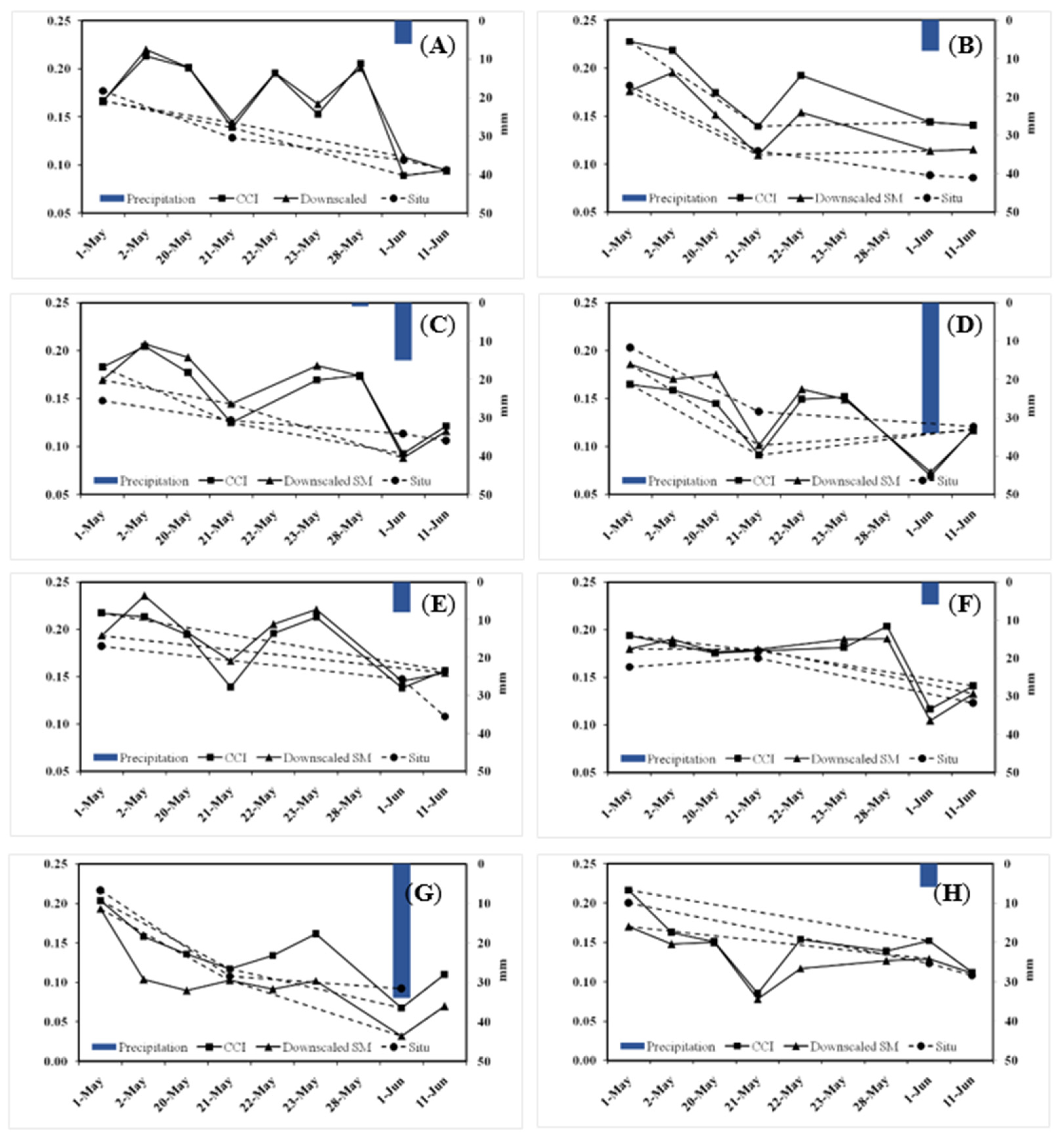
3.3. Evaluation of Downscaling Methods Using Time Series In Situ Observations
4. Discussion
4.1. Comparison of the Precision of Spatial Downscaling Algorithms
4.2. Spatial and Temporal Improvements for the Original CCI Data
4.3. Characteristics of the Proposed Method
- (1)
- SSCF constructed by MPDI. Referring to physical model-based methods in principle, the spatially downscaling method proposed in this paper utilized the MPDI, which has a strong correlation with SM, to construct SSCF and subsequently downscale the original SM products. MPDI data have the following two important characteristics: first, its value is calculated from the surface reflectance, which usually has a high spatial resolution, and can show a better correlation with the ground objects; second, its value is closely related to SM, and the fluctuation of MPDI time series can better reflect the dynamic change of SM. The above two characteristics of MPDI data were conducive to the improvement of the original CCI data in spatial and temporal dimensions, which supported the method proposed in this paper, which has the following advantages.
- (2)
- Finer spatial resolution. The various downscaling methods utilized in the past usually require land surface temperature data as input data [21,39]. However, land surface temperature data usually have low spatial resolutions, generally above 1 km [38,40], directly leading to traditional downscaling algorithms having difficulty obtaining downscaled results with a high spatial resolution. However, the proposed method needs only surface reflectance data, which usually have higher spatial resolutions, as the input data, so the proposed method can obtain downscaled results with higher spatial resolutions (e.g., 16 m).
- (3)
- High temporal resolution maintained. Higher spatial resolution is usually at the expense of temporal resolution, because higher spatial resolution data are often acquired by longer intervals and disturbed by more interference of clouds and fog. This “spatiotemporal contradiction” will lead to the low temporal resolution of downscaled data, and then cause a decrease in SM monitoring frequency. To solve this problem, a spatiotemporal data fusion algorithm (e.g., ESTARFM) was introduced in this paper to build a surface reflectance dataset with a high spatial and temporal resolution to ensure that not only the spatial fineness can be improved, but also the high temporal resolution can be maintained, thus better serving practical production applications.
- (4)
- Technical process simple and easy to implement. Some studies have effectively downscaled CCI SM products to a 30 m spatial resolution by combining a spatiotemporal data fusion algorithm with a random forest algorithm [12,32]. However, such methods require more input data than the proposed method. Additionally, their calculation processes are more complex. The technical process followed in this paper was divided into three steps. Further, the calculation process of each step was relatively simple. Compared with other downscaling methods, the proposed method not only requires fewer original data types but also has a relatively simple technical process. Therefore, the method proposed in this paper is easy to implement and has good practicability.
5. Conclusions
Author Contributions
Funding
Institutional Review Board Statement
Informed Consent Statement
Data Availability Statement
Conflicts of Interest
References
- Robock, A.; Vinnikov, K.Y.; Srinivasan, G.; Entin, J.K.; Hollinger, S.E.; Speranskaya, N.A.; Liu, S.; Namkhai, A. The global soil moisture data bank. Bull. Am. Meteorol. Soc. 2000, 81, 1281–1299. [Google Scholar] [CrossRef] [Green Version]
- Robinson, D.A.; Jones, S.B.; Wraith, J.M.; Or, D.; Friedman, S.P. A review of advances in dielectric and electrical conductivity measurement in soils using time domain reflectometry. Vadose Zone J. 2003, 2, 444–475. [Google Scholar] [CrossRef]
- Bogena, H.R.; Huisman, J.A.; Oberdörster, C.; Vereecken, H. Evaluation of a low-cost soil water content sensor for wireless network applications. J. Hydrol. 2007, 344, 32–42. [Google Scholar] [CrossRef]
- Samouëlian, A.; Cousin, I.; Tabbagh, A.; Bruand, A.; Richard, G. Electrical resistivity survey in soil science: A review. Soil Tillage Res. 2005, 83, 173–193. [Google Scholar] [CrossRef] [Green Version]
- Chen, S.; She, D.; Zhang, L.; Guo, M.; Liu, X. Spatial downscaling methods of soil moisture based on multisource remote sensing data and its application. Water 2019, 11, 1401. [Google Scholar] [CrossRef] [Green Version]
- Pan, N.; Wang, S.; Liu, Y.; Zhao, W.; Fu, B. Advances in soil moisture retrieval from remote sensing. Acta Ecol. Sin. 2019, 39, 1–12. [Google Scholar] [CrossRef]
- Han, Y.; Bai, X.; Shao, W.; Wang, J. Retrieval of soil moisture by integrating sentinel-1A and MODIS data over agricultural fields. Water 2020, 12, 1726. [Google Scholar] [CrossRef]
- Zhang, D.; Zhou, G. Estimation of soil moisture from optical and thermal remote sensing: A review. Sensors 2016, 16, 1308. [Google Scholar] [CrossRef] [PubMed] [Green Version]
- Peng, J.; Loew, A. Recent advances in soil moisture estimation from remote sensing. Water 2017, 9, 530. [Google Scholar] [CrossRef] [Green Version]
- Owe, M.; de Jeu, R.; Holmes, T. Multisensor historical climatology of satellite-derived global land surface moisture. J. Geophys. Res. 2008, 113, F01002. [Google Scholar] [CrossRef]
- Naeimi, V.; Scipal, K.; Bartalis, Z.; Hasenauer, S.; Wagner, W. An improved soil moisture retrieval algorithm for ERS and METOP scatterometer observations. IEEE Trans. Geosci. Remote Sens. 2009, 47, 1999–2013. [Google Scholar] [CrossRef]
- Jacquette, E.; Al Bitar, A.; Mialon, A.; Kerr, Y.; Quesney, A.; Cabot, F.; Richaume, P. SMOS CATDS level 3 global products over land. In Proceedings of the SPIE Remote Sensing for Agriculture, Ecosystems, and Hydrology XII, Toulouse, France, 20–23 September 2010. [Google Scholar] [CrossRef]
- Liu, Y.Y.; Parinussa, R.M.; Dorigo, W.A.; de Jeu, R.A.M.; Wagner, W.; van Dijk, A.I.J.M.; McCabe, M.F.; Evans, J.P. Developing an improved soil moisture dataset by blending passive and active microwave satellite-based retrievals. Hydrol. Earth Syst. Sci. 2011, 15, 425–436. [Google Scholar] [CrossRef] [Green Version]
- Peng, J.; Loew, A.; Merlin, O.; Verhoest, N.E.C. A review of spatial downscaling of satellite remotely sensed soil moisture. Rev. Geophys. 2017, 55, 341–366. [Google Scholar] [CrossRef]
- Zhao, W.; Li, A. A Downscaling method for improving the spatial resolution of AMSR-E derived soil moisture product based on MSG-SEVIRI data. Remote Sens. 2013, 5, 6790–6811. [Google Scholar] [CrossRef] [Green Version]
- Zhao, W.; Li, A.; Jin, H.; Zhang, Z.; Bian, J.; Yin, G. Performance evaluation of the triangle-based empirical soil moisture relationship models based on Landsat-5 TM data and in situ measurements. IEEE Trans. Geosci. Remote Sens. 2017, 55, 2632–2645. [Google Scholar] [CrossRef]
- Merlin, O.; Walker, J.; Chehbouni, A.; Kerr, Y. Towards deterministic downscaling of SMOS soil moisture using MODIS derived soil evaporative efficiency. Remote Sens. Environ. 2008, 112, 3935–3946. [Google Scholar] [CrossRef] [Green Version]
- Wang, J.; Ling, Z.; Wang, Y.; Zeng, H. Improving spatial representation of soil moisture by integration of microwave observations and the temperature–vegetation–drought index derived from MODIS products. ISPRS J. Photogramm. Remote Sens. 2016, 113, 144–154. [Google Scholar] [CrossRef] [Green Version]
- Liu, Y.; Yang, Y.; Jing, W.; Yue, X. Comparison of different machine learning approaches for monthly satellite-based soil moisture downscaling over Northeast China. Remote Sens. 2018, 10, 31. [Google Scholar] [CrossRef] [Green Version]
- Abowarda, A.S.; Bai, L.; Zhang, C.; Long, D.; Li, X.; Huang, Q.; Sun, Z. Generating surface soil moisture at 30 m spatial resolution using both data fusion and machine learning toward better water resources management at the field scale. Remote Sens. Environ. 2021, 255, 112301. [Google Scholar] [CrossRef]
- Kim, J.; Hogue, T.S. Improving spatial soil moisture representation through integration of AMSR-E and MODIS products. IEEE Trans. Geosci. Remote Sens. 2012, 50, 446–460. [Google Scholar] [CrossRef]
- Peng, J.; Loew, A.; Zhang, S.; Wang, J.; Niesel, J. Spatial downscaling of satellite soil moisture data using a vegetation temperature condition index. IEEE Trans. Geosci. Remote Sens. 2016, 54, 558–566. [Google Scholar] [CrossRef]
- Ghulam, A.; Qin, Q.; Teyip, T.; Li, Z.L. Modified perpendicular drought index (MPDI): A real-time drought monitoring method. ISPRS J. Photogramm. Remote Sens. 2007, 62, 150–164. [Google Scholar] [CrossRef]
- Li, Z.; Tan, D. A modified perpendicular drought index in NIR-Red reflectance space. IOP Conf. Ser. Earth Environ. Sci. 2014, 17, 012040. [Google Scholar] [CrossRef]
- Ju, J.; Roy, D.P. The availability of cloud-free Landsat ETM+ data over the conterminous United States and globally. Remote Sens. Environ. 2008, 112, 1196–1211. [Google Scholar] [CrossRef]
- Gao, F.; Masek, J.; Schwaller, M.; Hall, F. On the blending of the Landsat and MODIS surface reflectance: Predicting daily landsat surface reflectance. IEEE Trans. Geosci. Remote Sens. 2006, 44, 2207–2218. [Google Scholar] [CrossRef]
- Zhu, X.; Chen, J.; Gao, F.; Chen, X.; Masek, J.G. An enhanced spatial and temporal adaptive reflectance fusion model for complex heterogeneous regions. Remote Sens. Environ. 2010, 114, 2610–2623. [Google Scholar] [CrossRef]
- Zhang, W.; Li, A.; Jin, H.; Bian, J.; Zhang, Z.; Lei, G.; Qin, Z.; Huang, C. An enhanced spatial and temporal data fusion model for fusing landsat and MODIS surface reflectance to generate high temporal landsat-like data. Remote Sens. 2013, 5, 5346–5368. [Google Scholar] [CrossRef] [Green Version]
- Lu, M.; Chen, J.; Tang, H.; Rao, Y.; Yang, P.; Wu, W. Land cover change detection by integrating object-based data blending model of Landsat and MODIS. Remote Sens. Environ. 2016, 184, 374–386. [Google Scholar] [CrossRef]
- Huang, B.; Song, H. Spatiotemporal reflectance fusion via sparse representation. IEEE Trans. Geosci. Remote Sens. 2012, 50, 3707–3716. [Google Scholar] [CrossRef]
- Zhao, Y.; Huang, B.; Song, H. A robust adaptive spatial and temporal image fusion model for complex land surface changes. Remote Sens. Environ. 2018, 208, 42–62. [Google Scholar] [CrossRef]
- Li, Y.; Li, J.; He, L.; Chen, J.; Plaza, A. A sensor bias-driven spatio-temporal fusion model based on convolutional neural networks. Sci. China Inf. Sci. 2020, 63, 140302. [Google Scholar] [CrossRef] [Green Version]
- Hilker, T.; Wulder, M.A.; Coops, N.C.; Linke, J.; McDermid, G.; Masek, J.G.; Gao, F.; White, J.C. A new data fusion model for high spatial- and temporal-resolution mapping of forest disturbance based on Landsat and MODIS. Remote Sens. Environ. 2009, 113, 1613–1627. [Google Scholar] [CrossRef]
- Merlin, O.; Al Bitar, A.; Walker, J.P.; Kerr, Y. A sequential model for disaggregating near-surface soil moisture observations using multi-resolution thermal sensors. Remote Sens. Environ. 2009, 113, 2275–2284. [Google Scholar] [CrossRef] [Green Version]
- Wang, Y.; Leng, P.; Ma, J.; Peng, J. A method for downscaling satellite soil moisture based on land surface temperature and net surface shortwave radiation. IEEE Geosci. Remote Sens. Lett. 2021, 99, 1–5. [Google Scholar] [CrossRef]
- Ghulam, A.; Qin, Q.; Zhan, Z. Designing of the perpendicular drought index. Environ. Geol. 2007, 52, 1045–1052. [Google Scholar] [CrossRef]
- Colliander, A.; Fisher, J.B.; Halverson, G.; Merlin, O.; Misra, S.; Bindlish, R.; Jackson, T.J.; Yueh, S. Spatial downscaling of SMAP soil moisture using MODIS land surface temperature and NDVI during SMAPVEX15. IEEE Geosci. Remote Sens. Lett. 2017, 14, 2107–2111. [Google Scholar] [CrossRef] [Green Version]
- Wei, Z.; Meng, Y.; Zhang, W.; Peng, J.; Meng, L. Downscaling SMAP soil moisture estimation with gradient boosting decision tree regression over the Tibetan Plateau. Remote Sens. Environ. 2019, 225, 30–44. [Google Scholar] [CrossRef]
- Wen, F.; Zhao, W.; Wang, Q.; Sanchez, N. A value-consistent method for downscaling SMAP passive soil moisture with MODIS products using self-adaptive window. IEEE Trans. Geosci. Remote Sens. 2020, 58, 913–924. [Google Scholar] [CrossRef]
- Long, D.; Bai, L.; Yan, L.; Zhang, C.; Yang, W.; Lei, H.; Quan, J.; Meng, X.; Shi, C. Generation of spatially complete and daily continuous surface soil moisture of high spatial resolution. Remote Sens. Environ. 2019, 233, 111364. [Google Scholar] [CrossRef]


| GF6 | MOD09GA | ESA CCI | In Situ | ||||
|---|---|---|---|---|---|---|---|
| Date | Usage | Date | Usage | Date | Usage | Date | Usage |
| 1 May | ESTARFM algorithm input | 1 May | Original data for downscaling | 1 May | Validation | ||
| 2 May | ESTARFM algorithm input | 2 May | ESTARFM algorithm input | 2 May | Original data for downscaling | ||
| 20 May | ESTARFM algorithm input | 20 May | Original data for downscaling | ||||
| 21 May | ESTARFM algorithm input | 21 May | Original data for downscaling | 21 May | Validation | ||
| 22 May | ESTARFM algorithm input | 22 May | Original data for downscaling | ||||
| 23 May | ESTARFM algorithm input | 23 May | Original data for downscaling | ||||
| 28 May | ESTARFM algorithm input | 28 May | Original data for downscaling | ||||
| 3 June | ESTARFM algorithm input | 1 June | ESTARFM algorithm input | 1 June | Original data for downscaling | 1 June | Validation |
| 11 June | ESTARFM algorithm input | 11 June | Original data for downscaling | 11 June | Validation | ||
| Date | N | CCI | Downscaled | ||||
|---|---|---|---|---|---|---|---|
| RMSE (cm3/cm3) | R | Slope | RMSE (cm3/cm3) | R | Slope | ||
| 1 May | 37 | 0.029 | 0.43 | 0.61 | 0.025 | 0.57 | 0.76 |
| 21 May | 36 | 0.029 | 0.33 | 0.24 | 0.026 | 0.51 | 0.44 |
| 1 June | 37 | 0.032 | 0.35 | 0.32 | 0.031 | 0.45 | 0.48 |
| 11 June | 41 | 0.027 | 0.54 | 0.36 | 0.023 | 0.67 | 0.66 |
| Sites No. | Category | 1 May (cm3/cm3) | 21 May (cm3/cm3) | 1 June (cm3/cm3) | 11 June (cm3/cm3) | Mean (cm3/cm3) |
|---|---|---|---|---|---|---|
| 1 | CCI | 0.010 | 0.011 | 0.016 | 0.000 | 0.009 |
| Downscaled | 0.011 | 0.016 | 0.003 | 0.001 | 0.008 | |
| 2 | CCI | 0.046 | 0.026 | 0.056 | 0.054 | 0.045 |
| Downscaled | 0.006 | 0.004 | 0.026 | 0.029 | 0.016 | |
| 3 | CCI | 0.035 | 0.002 | 0.020 | 0.016 | 0.018 |
| Downscaled | 0.021 | 0.018 | 0.025 | 0.010 | 0.018 | |
| 4 | CCI | 0.039 | 0.045 | - | 0.003 | 0.029 |
| Downscaled | 0.017 | 0.035 | - | 0.004 | 0.019 | |
| 5 | CCI | 0.035 | - | 0.009 | 0.049 | 0.031 |
| Downscaled | 0.012 | - | 0.002 | 0.046 | 0.020 | |
| 6 | CCI | 0.033 | 0.008 | - | 0.018 | 0.020 |
| Downscaled | 0.019 | 0.009 | - | 0.010 | 0.012 | |
| 7 | CCI | 0.012 | 0.009 | 0.024 | - | 0.015 |
| Downscaled | 0.023 | 0.005 | 0.060 | - | 0.029 | |
| 8 | CCI | 0.017 | - | 0.029 | 0.004 | 0.017 |
| Downscaled | 0.030 | - | 0.006 | 0.003 | 0.013 | |
| Mean | CCI | 0.028 | 0.017 | 0.026 | 0.020 | 0.023 |
| Downscaled | 0.017 | 0.015 | 0.020 | 0.015 | 0.017 |
Publisher’s Note: MDPI stays neutral with regard to jurisdictional claims in published maps and institutional affiliations. |
© 2022 by the authors. Licensee MDPI, Basel, Switzerland. This article is an open access article distributed under the terms and conditions of the Creative Commons Attribution (CC BY) license (https://creativecommons.org/licenses/by/4.0/).
Share and Cite
Lu, X.; Zhao, H.; Huang, Y.; Liu, S.; Ma, Z.; Jiang, Y.; Zhang, W.; Zhao, C. Generating Daily Soil Moisture at 16 m Spatial Resolution Using a Spatiotemporal Fusion Model and Modified Perpendicular Drought Index. Sensors 2022, 22, 5366. https://doi.org/10.3390/s22145366
Lu X, Zhao H, Huang Y, Liu S, Ma Z, Jiang Y, Zhang W, Zhao C. Generating Daily Soil Moisture at 16 m Spatial Resolution Using a Spatiotemporal Fusion Model and Modified Perpendicular Drought Index. Sensors. 2022; 22(14):5366. https://doi.org/10.3390/s22145366
Chicago/Turabian StyleLu, Xin, Hongli Zhao, Yanyan Huang, Shuangmei Liu, Zelong Ma, Yunzhong Jiang, Wei Zhang, and Chuan Zhao. 2022. "Generating Daily Soil Moisture at 16 m Spatial Resolution Using a Spatiotemporal Fusion Model and Modified Perpendicular Drought Index" Sensors 22, no. 14: 5366. https://doi.org/10.3390/s22145366
APA StyleLu, X., Zhao, H., Huang, Y., Liu, S., Ma, Z., Jiang, Y., Zhang, W., & Zhao, C. (2022). Generating Daily Soil Moisture at 16 m Spatial Resolution Using a Spatiotemporal Fusion Model and Modified Perpendicular Drought Index. Sensors, 22(14), 5366. https://doi.org/10.3390/s22145366


