1. Introduction
Hurricanes, or tropical cyclones (TC), are characterized by high-speed winds, heavy precipitation, and low atmospheric pressure, that transform into natural disasters as they reach land [
1]. The major devastation occurs as a result of flooding [
2,
3]; therefore, rainfall estimation is very important for emergency evacuation planning. When a hurricane makes landfall, the most intense precipitation tends to occur in the vicinity of coastlines; predicting this event is a significant operational challenge [
4,
5]. However, flooding due to precipitation is not limited to coastlines, as seen in recent hurricanes where deadly floods reached well inland.
The storm’s progression and resulting hazard effects on land are often highly uncertain. Since the ensemble of forecasts changes during a TC, the uncertainty becomes dynamic, and it only ends when the storm’s evolution is known completely [
6,
7]. In order to generate a timely early warning system before and after the severe precipitation event, it is necessary to have instruments with high accuracy for detection, measurement, and tracking of storms [
8].
A powerful instrument to monitor severe events such as tropical cyclones is the Global Precipitation Measurement (GPM) mission, an international network of satellites used to provide accurate and timely information. GPM is an international partnership sponsored by NASA and the Japan Aerospace Exploration Agency (JAXA) that launched on 27 February 2014 [
9]. This network can provide valuable information needed to monitor the evolution of devastating storms, and helps scientists study their fast-moving and rapidly evolving nature [
10]. GPM carries two instruments: a passive microwave radiometer GMI and a dual-frequency precipitation radar (DPR) [
11]. The DPR consists of Ku-band (KuPR) and Ka-band (KaPR) radars on the GPM spacecraft bus, which are capable of measuring precipitation simultaneously [
12]. These radars operate at frequencies of 13.91 GHz and 35.56 GHz, respectively, and provide a three-dimensional observation of rain with an accurate estimation of rainfall rate. They are co-aligned and provide the same footprint location on the earth of 5 km. KuPR is suitable for heavy rainfall in the tropical region, and KaPR suitable for light rainfall in the higher latitude region [
13]. DPR lower and upper thresholds for rain rate measurements are 0.22 and 110.00 mm/h, respectively [
14].
Ground-based weather radars, which provide a spatial resolution of 1 km or less, are also used worldwide to detect and analyze rapidly moving severe storms, and to send timely alerts to the community [
15]. However, during severe and hazardous weather events, these instruments can be damaged and consequently stop providing valid information; this occurred when Hurricane Maria made landfall in Puerto Rico in 2017 and destroyed the only NEXRAD on the island. Therefore, during severe weather events, it is vital to have redundancy provided by satellite instruments in order to detect and monitor the events, while ensuring the uninterrupted transmission of timely information [
16].
When there are several instruments monitoring a weather event in the same region, the information must be consistent between the instruments, especially for large areas where hydrologic applications need information from multiple radar data. This information is susceptible to radar measurement differences in the overlapping zones, due to radar calibration, range effect, or both [
16]. In order to mitigate this problem, NASA developed an algorithm to match reflectivity from DPR and NEXRAD over different sampling volumes, and this effort has been of great importance for evaluating and improving algorithm performance [
17].
One of the most affected U.S. territories during hurricane season in the Atlantic Ocean is the island of Puerto Rico [
18,
19]. The most devastating hurricane that has impacted the island was Hurricane Maria in September 2017; however, Hurricane Irma also impacted Puerto Rico during that same month only 10 days earlier. Hurricane Irma was a category 5 hurricane with approximately 175-mile-per-hour winds, and was the strongest observed in the Atlantic in terms of maximum sustained wind [
20]. It lasted as a hurricane from 31 August until 11 September, and skirted the northeast region of Puerto Rico on 6 September 2017. This hurricane left more than 1 million people without electricity, some regions without potable water, and damaged roads and communication system infrastructure in Puerto Rico [
21].
During Hurricane Irma, the NWS in Puerto Rico used weather satellites and a NEXRAD radar to monitor the severe weather conditions. This radar is located in Cayey (18.12° N, 66.08° W, 886.63 m elevation), is identified as TJUA, and operates at a frequency of 2.7 GHz (S-Band). It has a maximum horizontal range of 462.5 km, and scans the entire island every 6 min with a spatial resolution of 1 km [
22].
In 2018, the remnants of Tropical Storm Beryl affected Puerto Rico and the U.S. Virgin Islands on 9 July. Strong winds and heavy rainfall affected Puerto Rico, where the average rainfall ranged from 1 to 6 inches. Several locations reported flash flooding. As a consequence of this tropical storm, at least 24,000 homes and businesses were without electricity, there were several fallen trees, and rivers rose over their banks; however, no injuries were reported [
1].
In September 2019, two extreme weather events hit Puerto Rico, Hurricane Dorian in 6 September, and Tropical Storm Karen in 24–25 September. Dorian was the first major hurricane of the 2019 Atlantic hurricane season. Although Dorian was less powerful than Hurricanes Irma and Maria, people from Puerto Rico prepared for the worst since they were still recovering from Maria. Fortunately, Hurricane Dorian’s projected path unexpectedly swerved northward and left only some residents without electricity, and some areas flooded.
Tropical Storm Karen became downgraded to a tropical depression when it hit Puerto Rico. On its way through the island, flooding occurred and power outages affected less than 10% of the total population.
This study presents an evaluation of GPM-DPR rainfall reflectivity against NEXRAD TJUA radar reflectivity during four extreme weather events and during normal precipitation events, in order to determine the degree of correlation between these two instruments. Measurement data from the extreme weather events in 2015–2019 were statistically analyzed, and reflectivity differences were broken down by precipitation type (stratiform and convective) and radar elevation angle, comparing KaPR and KuPR with NEXRAD TJUA separately.
The study results identified that the correlation coefficient between the data of both instruments during the extreme weather events was moderate to low, and for normal precipitation events the correlation is lower than that for other studies that compared GPM and NEXRAD reflectivity located at other sites in the USA.
However, Tropical Storm Karen had a better correlation coefficient for its four angles compared to the other extreme weather events. Likewise, the ground radar elevation angle and precipitation type have a substantial impact on how well the reflectivities match, and Ku-band possesses the least bias and variability when compared to ground radar reflectivity.
Since extreme weather events are frequent in this area, it highlights the importance of periodically conducting comparative studies to ensure consistency between instruments, in order to provide high accuracy information that allows timely decision making.
The structure of this article is as follows:
Section 2 presents a literature review of studies that compare matched data from satellite-based radars and ground radars in different regions of the globe.
Section 3 describes the methodology, data, and procedures used to carry out the cross-evaluation. Then,
Section 4 presents the results and the discussion of the cross-evaluation. Finally,
Section 5 shows the conclusions of this research.
3. Methodology
In order to obtain the matched data between GPM-DPR and NEXRAD during four extreme weather events and during normal precipitation events, the data products available from the GPM ground validation system (GVS) validation network (VN) were used.
The VN performs a direct match-up of DPR and GR data using the geometry-matching algorithm developed by NASA from the GPM terrestrial validation system (GVS) [
27].
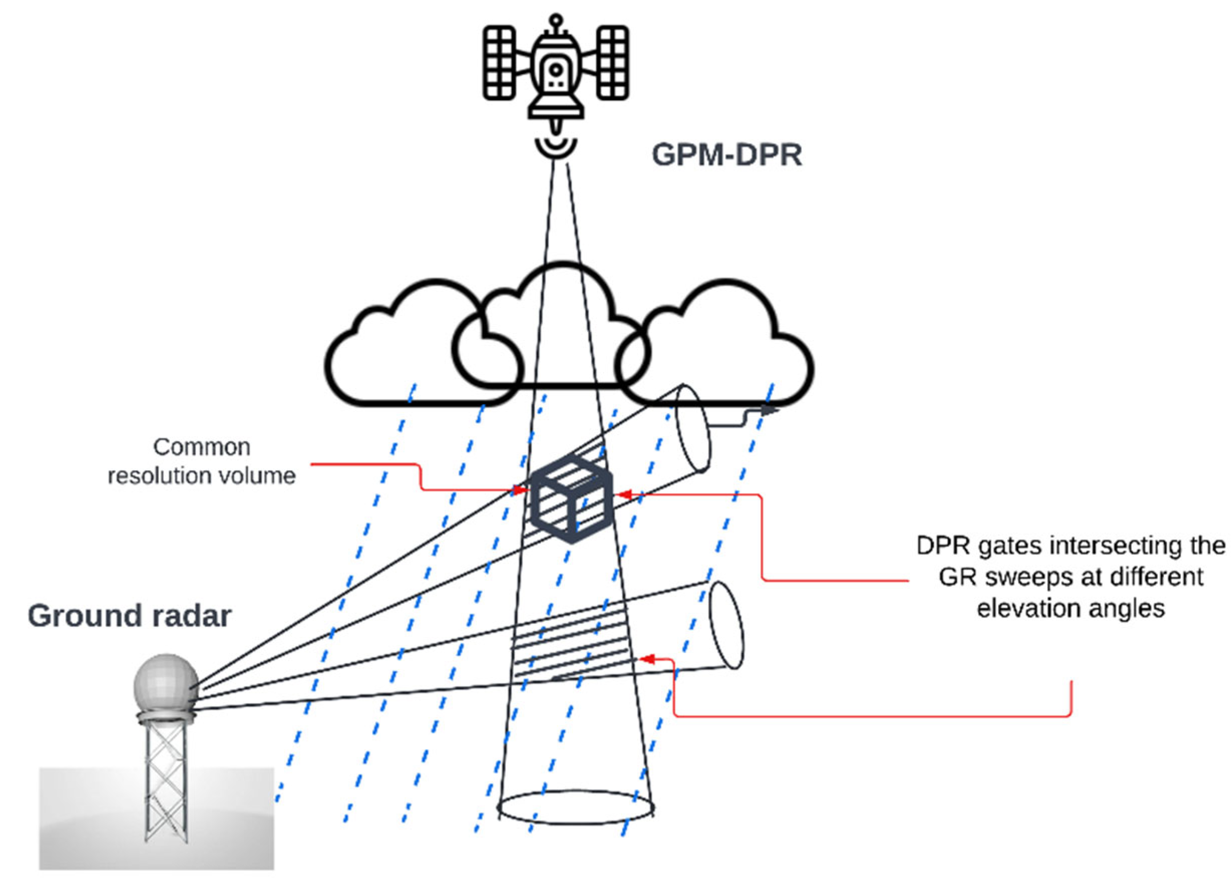
The algorithm determines the intersection of individual DPR rays with each of the elevation sweeps of the circular scanning ground-based radar, and the data outputs are stored as netCDF files. Due to the randomness of the beam-to-sweep intersections, the horizontal and vertical locations as well as the number of data points in the geometry matching technique are different; moreover, this algorithm allows for the identification of biases between ground observations and satellite recoveries.
Figure 1 shows the geometric intersections of DPR gates and GR sweeps at two different elevation angles.
The VN match-up data sets begins on 4 March 2014 (GMI) and 8 March 2014 (DPR, Ka, Ku, DPRGMI), but the matched data with NEXRAD TJUA began in 2015.
In order to select the match-ups, only those gates at or above a specified rain rate or reflectivity threshold are included in the DPR and GR gate averages (variables DPR_dBZ_min, GR_dBZ_min, and rain_min). These results are stored in netCDF variables [
9].
NEXRAD TJUA data and GPM Ku-band and Ka-band data for 2015 to 2019, in addition to four extreme weather events that occurred in this same period of time, are compared in terms of reflectivity differences for the first four matching elevation angles for the three scanning modes for the GR, and categorized by precipitation type.
The events for typical cases and for included extreme weather events cases do not surpass the DPR upper threshold sensitivity rain rate of 110.00 mm/h. On average, crossmatching between DPR and GR over NEXRAD TJUA occurs every four days; occasionally, there can be two consecutive days with match data, and up to a week for a match to occur. The average matching duration for GR and DPR is around 40 s, and DPR produces a swath scan every 300 milliseconds. For this reason, DPR is not a good substitute for GR in terms of continuous local weather monitoring; however, it is a useful instrument for GR data calibration and validation, and is also useful in the absence of local GR, as was the case in Puerto Rico after the damages suffered during Hurricane Maria.
GR has multiple scanning modes with different elevation angles, as
Figure 2 shows. Between 2015 and 2019, 165 cases with sufficient precipitation were selected for analysis, as well as the four extreme weather events.
Table 1 shows the selected elevation angles and their corresponding beam heights.
The algorithm for the files used is V05A version 1.3, and data within 100 km of the GR are used with a minimum threshold of 15 dBZ and a 7-km distance away from the GR.
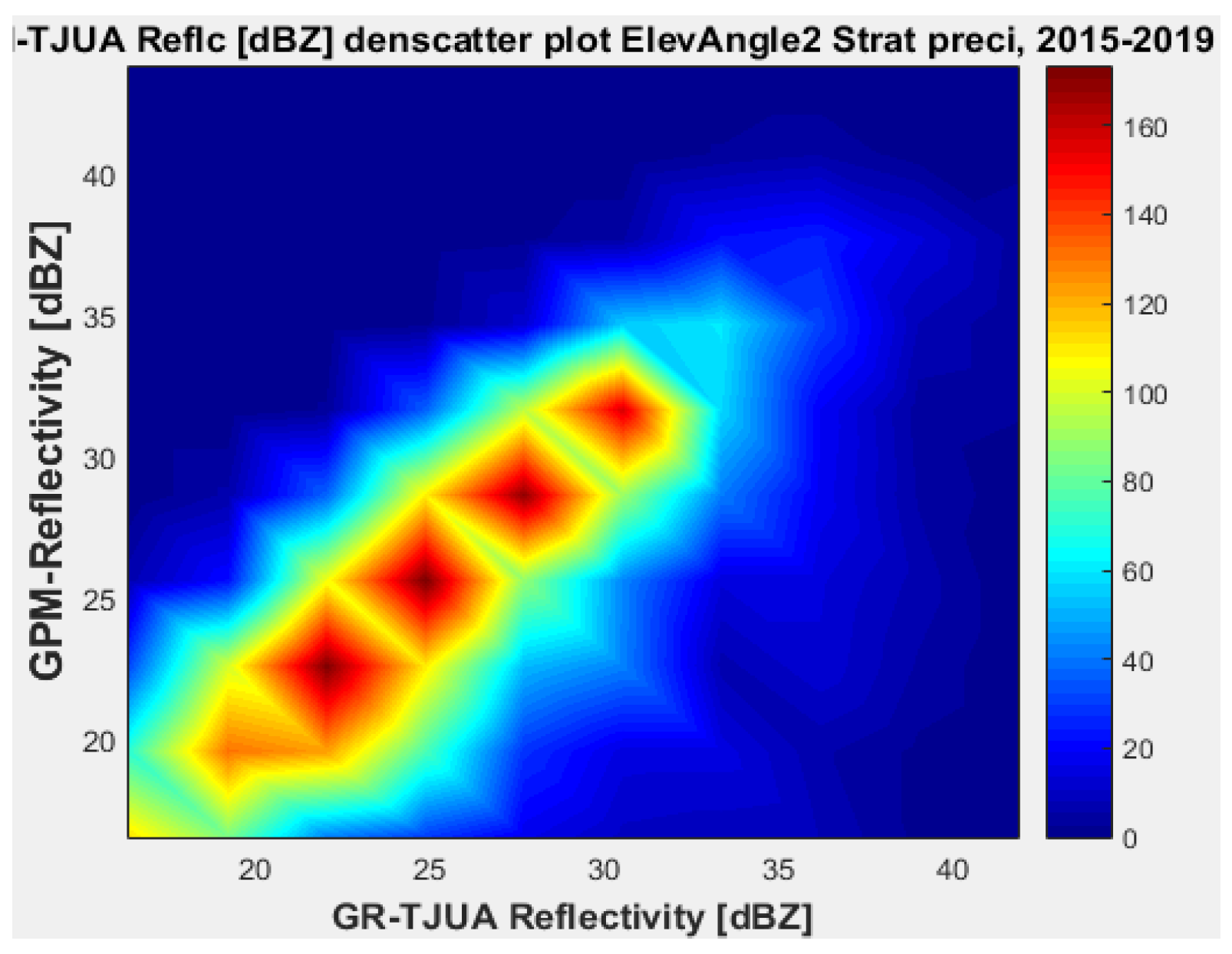
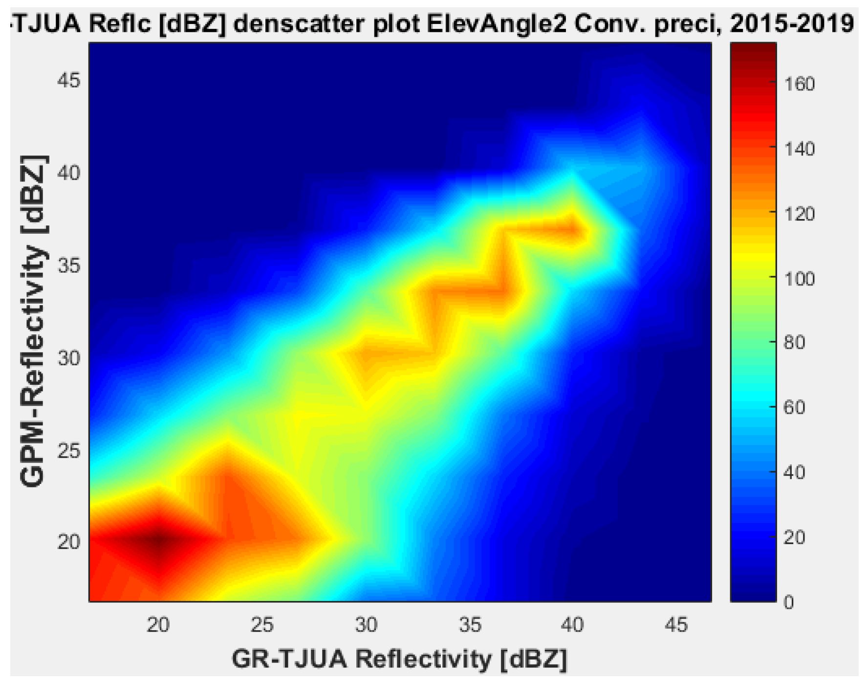
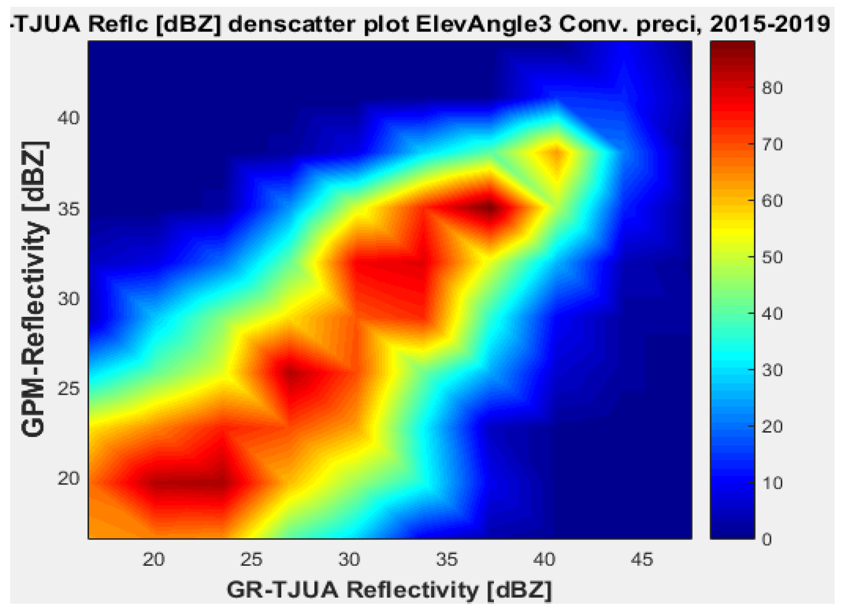
Each elevation angle is subcategorized by precipitation type, stratiform and convective; then, the bias is calculated, in addition to the variance, mean absolute error (MAE), mean square error (MSE), and root mean square (RMS), in order to determine variability in reflectivity differences under the different categorizations and subcategorizations, number of samples, and Pearson correlation coefficients (CC).
3.1. Extreme Weather Events
3.1.1. Hurricane Irma Data
Hurricane Irma’s eye passed north of Puerto Rico on 6 September by 8 p.m. as a category 5 storm. By 4 a.m. on 7 September, it passed north of the Dominican Republic; consequently, this is a single event comparison between NEXRAD and GPM on 7 September 2017.
Figure 3a presents GOES East satellite image of the Caribbean at the moment when Irma and GPM passed over PR on 7 September 2017;
Figure 3b shows the map of Puerto Rico with the ascending orbit of GPM over PR on 7 September 2017.
3.1.2. Tropical Storm Beryl
Hurricane Beryl weakened to a tropical storm on Saturday, 7 July 2018 as it approached islands in the eastern Caribbean. In Puerto Rico, between 9 and 10 July strong winds were reported; moreover, up to 8 inches of rain fell in some areas.
Figure 4 shows Tropical Storm Beryl over Puerto Rico.
3.1.3. Hurricane Dorian
In Puerto Rico, along the east and southeast, between the 28th and 29th of August, Hurricane Dorian left rainfall accumulations of between 4 and 6 inches, and generated flash flooding especially across the eastern end of Puerto Rico.
Figure 5 shows the closest point between GPM and GR on 29 August at 7:01 pm local time (11:01 UTC).
3.1.4. Tropical Storm Karen
Tropical Storm Karen is the weakest event compared to the other three.
Figure 6 shows the image captured by the GPM’s core satellite when it passed over Tropical Storm Karen on 25 September 2019 at 11:16 p.m. The most significant damages were heavy rains that led to flooded roads, flash flood warnings, and hazardous marine conditions.
The cross-evaluation of the four extreme weather events (Irma, Beryl, Dorian, and Karen) follow the same categorization and analysis as the normal weather conditions cases from the previous section; the biases were obtained, along with variances, mean absolute errors (MAE), mean square errors (MSE), root mean square (RMS), and the correlation coefficients for each GR elevation angle and subcategorized by precipitation type.
5. Conclusions
This study performed a cross-evaluation of reflectivity from GPM-DPRs for both Ku- and Ka-band against the ground-based radar NEXRAD located in Puerto Rico (TJUA), for two cases: during normal weather precipitation events and during four extreme weather events.
Data from TJUA in 2015–2019 (normal precipitation cases) and from the extreme weather events were compared in terms of biases and correlation coefficients, and used the first four matching elevation angles for the three scanning modes of the GR, and subsequently categorized by the type of precipitation (stratiform and convective).
The statistical analysis shows that Ku-band possesses the least bias and variability when compared to ground radar reflectivity; for this reason, DPR-Ku is better suited for reflectivity measurements in normal to moderate weather conditions in the Caribbean Region close to Puerto Rico.
Furthermore, the results showed that the elevation angle of the GR has a strong impact in how well the reflectivities match. Likewise, an elevation angle of 3.39 degrees was determined as the best to use for DPR-Ku in normal weather conditions, while for a severe event such as Hurricane Irma, a lower elevation angle such as 0.4843 degrees has the best matching for DPR-Ku and Ka.
The precipitation type also has a significant impact on how well matched the GR and DPR data are. For normal weather precipitation conditions, the stratiform type is statistically better for every GR elevation angle in comparison to the convective type. Similarly, when there are a lower number of convective types samples, the matching is improved, as is the case when the GR elevation angle is higher. Similarly, for Hurricane Irma, Tropical Storm Beryl, and Hurricane Dorian, the precipitation type also had a substantial impact on DPR-GR matching, with a lower GR elevation angle and convective type offering the best match.
However, in terms of the correlation coefficients for both cases, normal weather precipitation conditions and three of the extreme events (Hurricane Irma, Tropical Strom Beryl, and Hurricane Dorian), the results are lower than those from other studies that compared GPM-DPR observations with different NEXRAD locations in the U.S.A; therefore, it is necessary to apply corrective algorithms in order to improve the calibration of the GR located in Puerto Rico. It is necessary to increase the correlation of the data between GR and GPM so that they can provide accurate information for both rain events under normal conditions, and for severe events such as during tropical cyclones.


