


Management of Climate Resilience: Exploring the Potential of Digital Twin Technology, 3D City Modelling, and Early Warning Systems


Abstract
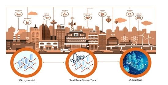
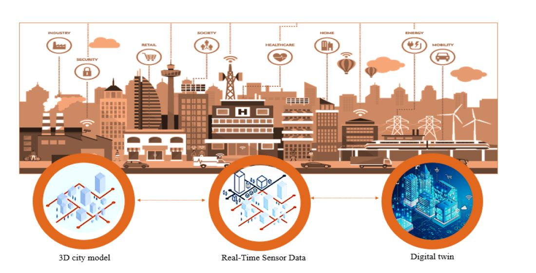
1. Introduction
2. Materials and Methods
2.1. Data Identification
2.2. Data Screening
3. Results
3.1. Category: Virtual City Modelling
- LOD 0—Regional, landscape;
- LOD 1—City, region;
- LOD 2—City districts, projects;
- LOD 3—Architectural models (exterior, landmarks);
- LOD 4—Architectural models (building interiors).

| Citation | Region | Application | LOD | 3D Modelling | Case Study | City Model | Real-Time Data | DT | Tools Utilised | Software Utilised |
|---|---|---|---|---|---|---|---|---|---|---|
| [45] | Taiwan | Sea level rise | LOD1 | 3D | √ | √ | × | × | Block model + generic texture model + photo-realistic economic model + photo-realistic detailed model. | Inet series + ArcGIS, +TerraSuite, +GeoBeans3D |
| [53] | Slovakia | Urban land management | LOD3 | 3D | √ | √ | × | × | Laser scanning + photogrammetry + electronic tachymetry + differential positioning through satellites | SketchUP + CAD + GIS (ArcGIS, GRASS GIS) |
| [46] | Taiwan | Flood | N/A | 3D | √ | √ | × | × | Integrating GIS with Geodesign + rule-based modelling | ArcGIS Pro 2.0 + CityEngine 2017.0 |
| [61] | Italy | Flood | LOD1 | 3D | √ | √ | × | × | LIDAR data + Texture mapping | ArcGIS® 10.3 + SketchUP |
| [44] | Korea | Flood | LOD1 | 3D | √ | √ | × | × | City Geography Markup Language (CityGML) | ArcMap + Hancel (Hancom Office) |
| [62] | China | Flood | Not mentioned | 3D | √ | × | × | × | LiDAR + Aerial imagery (UAV) + texture mapping | SketchUP |
| [57] | Germany | Flood | LOD1 + LOD2 | 3D | √ | × | × | × | CityGML + virtualcityMAP | SQL queries + GIS software |
| [56] | Italy | Flood | LOD2 | 2D + 3D | √ | √ | × | × | 3D point clouding + Terrestrial laser scanning + Airborne laser scanning + LiDAR + CityGML + Texture mapping | SketchUp + ArcGIS® 10.3 + CloudCompare |
| [54] | Spain | Flood | Not mentioned | 3D | √ | √ | × | × | LIDAR + CityGML | Not mentioned |
| [58] | China | Flood (waterlogging cities) | LOD1 | 3D | √ | × | × | × | CityGML | JDK, PostSQL, Tomcat |
| [51] | General | Flood | LOD1 | N/A | × | × | × | × | CityGML + Web 3D GIS + X3D + WebGL + X3DOM + GeoServer3D + jQuery | Linux (Ubuntu) + Blender + SketchUp |
| [47] | Oman | Flash flood | LoD1 | 3D | √ | √ | × | × | CityGML + Watershed Modelling System + Visualising tools (FZK viewer and Cesium) | ArcGIS + PostgreSQL-PostGIS + FME engine |
| [55] | Spain | Flood | LOD1 and LOD2 | 3D | √ | √ | × | × | LIDAR + DTM + CityGML | Not mentioned |
| [63] | Spain | Decarbonisation | N/A | N/A | √ | × | × | × | ENER-BI + Cities4ZERO | QGIS + PowerBI + Influxdb, PostgreSQL + Postgis + EnergyPlus + EnergyPLAN |
| [64] | General | Urban microclimate | N/A | N/A | × | × | √ | √ | Satellite sensors | Not mentioned |
3.2. Category: Early Warning System
| Citation | Region | Category | Application | IoT | Case Study | Early Warning System | Real-Time Data | DT | Sensors Mentioned | Software Mentioned |
|---|---|---|---|---|---|---|---|---|---|---|
| [74] | US | Conference paper | Flood | √ | √ | × | √ | × | Ultrasonic sensor + Water level sensors | Sqlite3 + AWSEC2 |
| [86] | General | Review paper | Landslide | × | × | √ | √ | × | Wireless network sensors | Kubernetes + Docker |
| [87] | General | Review paper | General Study | √ | × | × | × | × | None | None |
| [88] | US | Book | Flood | × | × | √ | √ | × | NEXRAD radar + Telemetric tipping bucket rain gauge | xgboost |
| [89] | Bangladesh | Case study | Landslide | × | √ | √ | × | × | None | Rasterpack Python + mysql + rclimdex + GDAL |
| [68] | Malaysia | Case study | Landslide | √ | √ | √ | √ | × | Satellite and airborne monitoring | Arcsde v9.3 + Geomatica 10.1 + arcgis + JAVA Enterprise Edition (J2EETM) |
| [75] | Taiwan | Case study | Landslide | × | √ | √ | √ | × | Not mentioned | QPESUMS + rilews |
| [90] | Europe | Review Paper | Flood | × | × | √ | × | × | Not mentioned | Not Mentioned |
| [81] | India | Case study | Landslide | × | √ | √ | √ | × | Rainfall Sensor, Temperature, Humidity, Wind speed, Wind direction, Soil moisture, temperature and Tiltmeter sensor. | Not Mentioned |
| [70] | China | Conference Paper | Landslide | × | √ | √ | √ | × | Force sensor, laser sensor, crack deformation sensor, data Acquisition and transmission device, power supply device, and communication antenna | Not Mention |
| [80] | Europe | Book | Tsunami | × | × | √ | √ | × | Seismic alerting devices (consist of eight sensors) + Radar-type (ultrasonic) tide gauges | Not mentioned |
| [91] | Cyprus | Case study | Flood | × | √ | √ | × | × | None | Decatastrophize (DECAT) |
| [76] | General | General Study | Disaster management | √ | × | √ | √ | √ | General | General |
| [72] | India | Case study | Landslide | × | √ | √ | √ | × | Wireless Sensor Networks based on microelectronicmechanical systems + Tilt sensor + Water content sensors | Not mentioned |
| [73] | China | Case study | Flooding | √ | √ | √ | √ | × | Remote sensing stations + RFID + mobile phones + webcam + Other sensors | Not mentioned |
| [71] | Indonesia | Case study | Tsunami | × | √ | √ | √ | × | Tide gauge sensors | GIS software + QGIS |
| [79] | China | Conference paper | Landslide | × | √ | √ | √ | × | Temperature and humidity sensors + HD cameras + Panoramic camera | Arcgis + arcxml + javascript + Java API + arcsde |
| [78] | General | Conference paper | Landslide | × | × | √ | √ | × | Wireless Sensor Networks based on microelectronic mechanical systems | Arcgis + webgis (arcims) + Temporal GIS + arcsde |
| [77] | Greece | Conference paper | Flood | × | × | √ | √ | × | Water Level Sensor + SYMMETRON’s Stylitis 20 | Webgis (mysql) + Node.js + Dygraphs JS + sdks |
| [69] | General | Conference paper | Flood | × | × | √ | √ | × | General | General |
| [82] | Myanmar | Conference paper | Landside | √ | √ | √ | √ | × | Rain gauge sensor + Accelerometer sensor + Soil moisture sensor + Temperature sensor + Piezometer sensor | Not mentioned |
3.3. Category: Digital Twin
| Citation | Study Type | Region | Case Study | Real-Time Data | 3D Model | Applications | Tools Utilized/Describe |
|---|---|---|---|---|---|---|---|
| [105] | Journal Article | New Zealand | √ | √ | √ | Wetland (Flood and storms) | IoT sensors + Social sensors data + thingworx + AR UX |
| [97] | Journal article | Ireland | × | × | × | Flood | Skyline simulation + flood simulation + crowd simulation + User tagging simulation |
| [106] | Review Paper | General | × | × | × | Climate resilience | N/A |
| [107] | Review Paper | Saudi Arabia | × | × | × | Flood | N/A |
| [16] | Conference Paper | General | × | × | × | General | N/A |
| [108] | Journal Article | China | √ | × | √ | Flood | 3D hydrodynamic mode + Digital aerial photogrammetry + Oblique images + |
| [109] | Review paper | General | × | × | × | Smart city management | CityGML+ 3D city model |
| [110] | Journal Article | Singapore | √ | √ | √ | Urban landscape management | LiDAR + Point cloud modelling + geo-specific digital 3D Models (Laser scanning) + Voxel model + Computational fluid dynamics |
| [111] | Journal article | Norway | √ | × | √ | Extreme climate modelling | FKB-Laser10 + Digital elevation maps + GIS-tool Calamity Levels of Urban Drainage Systems |
| [112] | Review Paper | General | × | × | × | Smart City management | N/A |
| [113] | Journal article | China | √ | × | √ | Smart city management (Heat Island/ Forest cover) | Remote sensing + satellite image data |
| [114] | Journal Article | South Korea | √ | × | √ | Smart city management (carbon emissions) | Raw Data + 3D building data + the carbon emissions values of the four factors estimated including the creation of a city model (LOD 1) |
| [115] | Journal Article | US | √ | √ | √ | Smart city management (carbon emissions) | CityGML + OGC Sensor Things API standard |
| [116] | Review Paper | General study | × | × | × | Sustainability | N/A |
| [117] | Journal Article | Norway | √ | √ | √ | City Management | Traffic visualization + Heat maps + 3D city models |
| [118] | Conference Paper | General | × | × | × | Smart city management | N/A |
| [119] | Conference Paper | Japan | × | × | × | Smart city management | N/A |
| [120] | Conference Paper | Finland | × | × | × | Smart city management | CityGML Explanation |
| [37] | Review Paper | General | × | × | × | Smart City Management | N/A |
| [93] | Conference Paper | General | × | × | × | City Management | Surveillance cameras + pressure sensors + humidity sensors + temperature sensors + air pollution sensors + geolocation data of vehicles + information from passengers’ travel cards |
| [121] | Journal Articles | Germany | √ | √ | √ | City management | 3D Street network model with space syntax + Urban mobility simulation with (SUMO) Simulation of Urban Mobility + Airflow simulation + Sensor network data (Temp, humidity), + social data |
| [102] | Journal Articles | General | × | × | × | Flood | Social Sensing (graph-based approach + image-ranking algorithm + Situational Awareness) |
| [94] | Journal Articles | General | × | × | × | Disaster city management | N/A |
| [98] | Journal Articles | US | √ | √ | √ | Disaster city management | Participatory sensing + crowdsourced visual data |
| [122] | Review Paper | General | × | × | × | General Study | N/A |
| [123] | Journal Articles | General | × | × | × | Agricultural sector | WebGIS + Satellite imagery + remotely sensed data |
| [124] | Journal Articles | General | × | × | × | Disaster city management | Remote sensing + Synthetic aperture radar + LiDAR + Optical and thermal range + social sensing + crowdsourcing |
4. Discussion
4.1. Challenges and Limitations in the Adoption and Implementation of Digital Twin Technology for Climate Resilience
4.2. Future Directions
4.3. Summary
5. Conclusions
Author Contributions
Funding
Institutional Review Board Statement
Informed Consent Statement
Data Availability Statement
Conflicts of Interest
References
- World Urbanization Prospects 2018: Highlights; United Nations: San Francisco, CA, USA, 2018; ISBN 978-92-1-148318-5. Available online: https://population.un.org/wup/publications/Files/WUP2018-Highlights.pdf (accessed on 12 May 2022).
- Dorling, D. World Population Prospects at the UN: Our Numbers Are Not Our Problem? In The Struggle for Social Sustainability: Moral Conflicts in Global Social Policy; Policy Press: Bristol, UK, 2021; p. 129. [Google Scholar]
- World Urbanization Prospects 2019: Highlights; United Nations: San Francisco, CA, USA, 2019; Available online: https://espas.secure.europarl.europa.eu/orbis/sites/default/files/generated/document/en/WPP2019_Highlights.pdf (accessed on 13 May 2022).
- Edmonds, D.A.; Caldwell, R.L.; Brondizio, E.S.; Siani, S.M. Coastal Flooding Will Disproportionately Impact People on River Deltas. Nat. Commun. 2020, 11, 4741. [Google Scholar] [CrossRef] [PubMed]
- Lorie, M.; Neumann, J.E.; Sarofim, M.C.; Jones, R.; Horton, R.M.; Kopp, R.E.; Fant, C.; Wobus, C.; Martinich, J.; O’Grady, M. Modeling Coastal Flood Risk and Adaptation Response under Future Climate Conditions. Clim. Risk Manag. 2020, 29, 100233. [Google Scholar] [CrossRef] [PubMed]
- Cardona, F.S.; Ferreira, J.C.; Lopes, A.M. Cost and Benefit Analysis of Climate Change Adaptation Strategies in Coastal Areas at Risk. J. Coast. Res. 2020, 95, 764–768. [Google Scholar] [CrossRef]
- Losada, I.J.; Toimil, A.; Munoz, A.; Garcia-Fletcher, A.P.; Diaz-Simal, P. A Planning Strategy for the Adaptation of Coastal Areas to Climate Change: The Spanish Case. Ocean Coast. Manag. 2019, 182, 104983. [Google Scholar] [CrossRef]
- Nitivattananon, V.; Srinonil, S. Enhancing Coastal Areas Governance for Sustainable Tourism in the Context of Urbanization and Climate Change in Eastern Thailand. Adv. Clim. Chang. Res. 2019, 10, 47–58. [Google Scholar] [CrossRef]
- Wolf, J.; Woolf, D.; Bricheno, L. Impacts of Climate Change on Storms and Waves Relevant to the Coastal and Marine Environment around the UK. MCCIP Sci. Rev. 2020, 2020, 132–157. [Google Scholar]
- Tockner, K.; Tonolla, D.; Bremerich, V.; Jähnig, S.C.; Robinson, C.T.; Zarfl, C. Introduction to European Rivers. In Rivers of Europe; Elsevier: Amsterdam, The Netherlands, 2022; pp. 1–26. [Google Scholar]
- Ciampa, F.; Seifollahi-Aghmiuni, S.; Kalantari, Z.; Ferreira, C.S. Flood Mitigation in Mediterranean Coastal Regions: Problems, Solutions, and Stakeholder Involvement. Sustainability 2021, 13, 474. [Google Scholar] [CrossRef]
- Carattoli, A.; Villa, L.; Feudi, C.; Curcio, L.; Orsini, S.; Luppi, A.; Pezzotti, G.; Magistrali, C.F. Novel Plasmid-Mediated Colistin Resistance Mcr-4 Gene in Salmonella and Escherichia Coli, Italy 2013, Spain and Belgium, 2015 to 2016. Eurosurveillance 2017, 22, 30589. [Google Scholar] [CrossRef]
- Diakakis, M.; Priskos, G.; Skordoulis, M. Public Perception of Flood Risk in Flash Flood Prone Areas of Eastern Mediterranean: The Case of Attica Region in Greece. Int. J. Disaster Risk Reduct. 2018, 28, 404–413. [Google Scholar] [CrossRef]
- Ganguli, P.; Merz, B. Extreme Coastal Water Levels Exacerbate Fluvial Flood Hazards in Northwestern Europe. Sci. Rep. 2019, 9, 1–14. [Google Scholar] [CrossRef]
- Mel, R.A.; Viero, D.P.; Carniello, L.; D’Alpaos, L. Optimal Floodgate Operation for River Flood Management: The Case Study of Padova (Italy). J. Hydrol. Reg. Stud. 2020, 30, 100702. [Google Scholar] [CrossRef]
- Mashaly, M. Connecting the Twins: A Review on Digital Twin Technology & Its Networking Requirements. Procedia Comput. Sci. 2021, 184, 299–305. [Google Scholar]
- Jan, O.R.; Jo, H.S.; Jo, R.S.; Kua, J. Real-Time Flood Monitoring with Computer Vision through Edge Computing-Based Internet of Things. Future Internet 2022, 14, 308. [Google Scholar] [CrossRef]
- Sulasikin, A.; Nugrahat, Y.; Aminanto, M.E.; Nasution, B.I.; Kanggrawan, J.I. Developing a Knowledge Management System for Supporting Flood Decision-Making. In Proceedings of the 2022 IEEE International Smart Cities Conference (ISC2), Pafos, Cyprus, 26–29 September 2022; pp. 1–4. [Google Scholar]
- Haag, S.; Anderl, R. Digital Twin–Proof of Concept. Manuf. Lett. 2018, 15, 64–66. [Google Scholar] [CrossRef]
- Vachálek, J.; Bartalský, L.; Rovný, O.; Šišmišová, D.; Morháč, M.; Lokšík, M. The Digital Twin of an Industrial Production Line within the Industry 4.0 Concept. In Proceedings of the IEEE 2017 21st International Conference on Process Control (PC), Štrbské Pleso, Slovakia, 6–9 June 2017; pp. 258–262. [Google Scholar]
- Wright, L.; Davidson, S. How to Tell the Difference between a Model and a Digital Twin. Adv. Model. Simul. Eng. Sci. 2020, 7, 13. [Google Scholar] [CrossRef]
- Kharchenko, V.; Illiashenko, O.; Morozova, O.; Sokolov, S. Combination of Digital Twin and Artificial Intelligence in Manufacturing Using Industrial IoT. In Proceedings of the 2020 IEEE 11th International Conference on Dependable Systems, Services and Technologies (DESSERT), Kyiv, Ukraine, 14–18 May 2020; pp. 196–201. [Google Scholar]
- Kritzinger, W.; Karner, M.; Traar, G.; Henjes, J.; Sihn, W. Digital Twin in Manufacturing: A Categorical Literature Review and Classification. Ifac-PapersOnline 2018, 51, 1016–1022. [Google Scholar] [CrossRef]
- Zheng, Y.; Yang, S.; Cheng, H. An Application Framework of Digital Twin and Its Case Study. J. Ambient Intell. Humaniz. Comput. 2019, 10, 1141–1153. [Google Scholar] [CrossRef]
- Ramaprasad, A.; Sánchez-Ortiz, A.; Syn, T. A Unified Definition of a Smart City. In Proceedings of the Electronic Government: 16th IFIP WG 8.5 International Conference, EGOV 2017, St. Petersburg, Russia, 4–7 September 2017; Springer: Berlin/Heidelberg, Germany, 2017; pp. 13–24. [Google Scholar]
- Shaharuddin, S.; Abdul Maulud, K.N.; Syed Abdul Rahman, S.A.F.; Che Ani, A.I. Digital Twin for Indoor Disaster in Smart City: A Systematic Review. ISPRS Ann. Photogramm. Remote Sens. Spat. Inf. Sci. 2021, 46, 315–322. [Google Scholar] [CrossRef]
- Caprari, G. Digital Twin for Urban Planning in the Green Deal Era: A State of the Art and Future Perspectives. Sustainability 2022, 14, 6263. [Google Scholar] [CrossRef]
- Gowran, L.M. EU to Develop a Digital Twin of Earth to Better Predict Climate Impact. Available online: https://www.siliconrepublic.com/innovation/eu-commission-digital-replica-earth-climate (accessed on 5 May 2022).
- Hazlegreaves, S. Increasing Climate Resilience through Connected Digital Twins. Planning, BIM & Construction Today. 2021. Available online: https://www.pbctoday.co.uk/news/digital-construction/digital-twins/climate-resilience-demonstrator/102198/ (accessed on 12 May 2022).
- Pillai, U.P.A.; Pinardi, N.; Alessandri, J.; Federico, I.; Causio, S.; Unguendoli, S.; Valentini, A.; Staneva, J. A Digital Twin Modelling Framework for the Assessment of Seagrass Nature Based Solutions against Storm Surges. Sci. Total Environ. 2022, 847, 157603. [Google Scholar] [CrossRef] [PubMed]
- Kaur, M.J.; Mishra, V.P.; Maheshwari, P. The Convergence of Digital Twin, IoT, and Machine Learning: Transforming Data into Action. In Digital Twin Technologies and Smart Cities; Springer: Berlin/Heidelberg, Germany, 2020; pp. 3–17. [Google Scholar]
- Tao, F.; Cheng, J.; Qi, Q.; Zhang, M.; Zhang, H.; Sui, F. Digital Twin-Driven Product Design, Manufacturing and Service with Big Data. Int. J. Adv. Manuf. Technol. 2018, 94, 3563–3576. [Google Scholar] [CrossRef]
- El Khatib, M.M.; Al-Nakeeb, A.; Ahmed, G. Integration of Cloud Computing with Artificial Intelligence and Its Impact on Telecom Sector—A Case Study. iBusiness 2019, 11, 1. [Google Scholar] [CrossRef]
- Qi, Q.; Zhao, D.; Liao, T.W.; Tao, F. Modeling of Cyber-Physical Systems and Digital Twin Based on Edge Computing, Fog Computing and Cloud Computing towards Smart Manufacturing. In Proceedings of the International Manufacturing Science and Engineering Conference; American Society of Mechanical Engineers, Shenzhen, China, 30–31 March 2018; Volume 51357, p. V001T05A018. [Google Scholar]
- Zhou, H.; Yang, C.; Sun, Y. Intelligent Ironmaking Optimization Service on a Cloud Computing Platform by Digital Twin. Engineering 2021, 7, 1274–1281. [Google Scholar] [CrossRef]
- Alexopoulos, K.; Nikolakis, N.; Chryssolouris, G. Digital Twin-Driven Supervised Machine Learning for the Development of Artificial Intelligence Applications in Manufacturing. Int. J. Comput. Integr. Manuf. 2020, 33, 429–439. [Google Scholar] [CrossRef]
- Mylonas, G.; Kalogeras, A.; Kalogeras, G.; Anagnostopoulos, C.; Alexakos, C.; Muñoz, L. Digital Twins From Smart Manufacturing to Smart Cities: A Survey. IEEE Access 2021, 9, 143222–143249. [Google Scholar] [CrossRef]
- Schrotter, G.; Hürzeler, C. The Digital Twin of the City of Zurich for Urban Planning. PFG–J. Photogramm. Remote Sens. Geoinf. Sci. 2020, 88, 99–112. [Google Scholar] [CrossRef]
- McCausland, T. Digital Twins; Taylor & Francis: London, UK, 2021; Volume 65, pp. 69–71. ISBN 0895-6308. [Google Scholar]
- Deng, T.; Zhang, K.; Shen, Z.-J. A Systematic Review of a Digital Twin City: A New Pattern of Urban Governance toward Smart Cities. J. Manag. Sci. Eng. 2021, 6, 125–134. [Google Scholar] [CrossRef]
- Aromataris, E.; Pearson, A. The Systematic Review: An Overview. AJN Am. J. Nurs. 2014, 114, 53–58. [Google Scholar] [CrossRef]
- Kumar, P.; Debele, S.E.; Sahani, J.; Rawat, N.; Marti-Cardona, B.; Alfieri, S.M.; Basu, B.; Basu, A.S.; Bowyer, P.; Charizopoulos, N.; et al. An Overview of Monitoring Methods for Assessing the Performance of Nature-Based Solutions against Natural Hazards. Earth-Sci. Rev. 2021, 217, 103603. [Google Scholar] [CrossRef]
- Page, M.J.; McKenzie, J.E.; Bossuyt, P.M.; Boutron, I.; Hoffmann, T.C.; Mulrow, C.D.; Shamseer, L.; Tetzlaff, J.M.; Akl, E.A.; Brennan, S.E. The PRISMA 2020 Statement: An Updated Guideline for Reporting Systematic Reviews. Int. J. Surg. 2021, 88, 105906. [Google Scholar] [CrossRef]
- Jang, Y.-H.; Park, S.I.; Kwon, T.H.; Lee, S.-H. CityGML Urban Model Generation Using National Public Datasets for Flood Damage Simulations: A Case Study in Korea. J. Environ. Manag. 2021, 297, 113236. [Google Scholar] [CrossRef] [PubMed]
- Rau, J.-Y.; Cheng, C.-K. A Cost-Effective Strategy for Multi-Scale Photo-Realistic Building Modeling and Web-Based 3-D GIS Applications in Real Estate. Comput. Environ. Urban Syst. 2013, 38, 35–44. [Google Scholar] [CrossRef]
- Wu, C.-L.; Chiang, Y.-C. A Geodesign Framework Procedure for Developing Flood Resilient City. Habitat Int. 2018, 75, 78–89. [Google Scholar] [CrossRef]
- Al Kalbani, K.; Rahman, A. 3D City Model for Monitoring Flash Flood Risks in Salalah, Oman. Int. J. Eng. Geosci. 2022, 7, 17–23. [Google Scholar] [CrossRef]
- Büyüksalih, İ.; Alkan, M.; GAZİOĞLU, C.G. Design for 3D City Model Management Using Remote Sensing and GIS: A Case Study for the Golden Horn in Istanbul, Turkey. Sigma J. Eng. Nat. Sci. 2019, 37, 1450–1466. [Google Scholar]
- Jovanović, D.; Milovanov, S.; Ruskovski, I.; Govedarica, M.; Sladić, D.; Radulović, A.; Pajić, V. Building Virtual 3D City Model for Smart Cities Applications: A Case Study on Campus Area of the University of Novi Sad. ISPRS Int. J. Geo-Inf. 2020, 9, 476. [Google Scholar] [CrossRef]
- Pepe, M.; Costantino, D.; Alfio, V.S.; Vozza, G.; Cartellino, E. A Novel Method Based on Deep Learning, GIS and Geomatics Software for Building a 3D City Model from VHR Satellite Stereo Imagery. ISPRS Int. J. Geo-Inf. 2021, 10, 697. [Google Scholar] [CrossRef]
- Surmann, H.; Slomma, D.; Grafe, R.; Grobelny, S. Deployment of Aerial Robots During the Flood Disaster in Erftstadt/Blessem in July 2021. In Proceedings of the IEEE 2022 8th International Conference on Automation, Robotics and Applications (ICARA), Prague, Czech Republic, 18–20 February 2022; pp. 97–102. [Google Scholar]
- Newman, G.; Malecha, M.; Yu, S.; Qiao, Z.; Horney, J.A.; Lee, J.; Kim, Y.J.; Lee, R.J.; Berke, P. Integrating a Resilience Scorecard and Landscape Performance Tools into a Geodesign Process. Landsc. Res. 2020, 45, 63–80. [Google Scholar] [CrossRef]
- Zhou, G.; Tan, Z.; Cen, M.; Li, C. Customizing Visualization in Three-Dimensional Urban GIS via Web-Based Interaction. J. Urban Plan. Dev. 2006, 132, 97–103. [Google Scholar] [CrossRef]
- Gandini, A.; Garmendia, L.; Prieto, I.; Álvarez, I.; San-José, J.-T. A Holistic and Multi-Stakeholder Methodology for Vulnerability Assessment of Cities to Flooding and Extreme Precipitation Events. Sustain. Cities Soc. 2020, 63, 102437. [Google Scholar] [CrossRef]
- Gandini, A.; Quesada, L.; Prieto, I.; Garmendia, L. Climate Change Risk Assessment: A Holistic Multi-Stakeholder Methodology for the Sustainable Development of Cities. Sustain. Cities Soc. 2021, 65, 102641. [Google Scholar] [CrossRef]
- Costabile, P.; Costanzo, C.; De Lorenzo, G.; De Santis, R.; Penna, N.; Macchione, F. Terrestrial and Airborne Laser Scanning and 2-D Modelling for 3-D Flood Hazard Maps in Urban Areas: New Opportunities and Perspectives. Environ. Model. Softw. 2021, 135, 104889. [Google Scholar] [CrossRef]
- Schröter, K.; Lüdtke, S.; Redweik, R.; Meier, J.; Bochow, M.; Ross, L.; Nagel, C.; Kreibich, H. Flood Loss Estimation Using 3D City Models and Remote Sensing Data. Environ. Model. Softw. 2018, 105, 118–131. [Google Scholar] [CrossRef]
- Shen, J.; Zhou, J.; Zhou, J.; Herman, L.; Reznik, T. Constructing the CityGML ADE for the Multi-Source Data Integration of Urban Flooding. Isprs Int. J. Geo-Inf. 2020, 9, 359. [Google Scholar] [CrossRef]
- Ledoux, H.; Arroyo Ohori, K.; Kumar, K.; Dukai, B.; Labetski, A.; Vitalis, S. CityJSON: A Compact and Easy-to-Use Encoding of the CityGML Data Model. Open Geospat. Data Softw. Stand. 2019, 4, 4. [Google Scholar] [CrossRef]
- Virtanen, J.-P.; Jaalama, K.; Puustinen, T.; Julin, A.; Hyyppä, J.; Hyyppä, H. Near Real-Time Semantic View Analysis of 3D City Models in Web Browser. ISPRS Int. J. Geo-Inf. 2021, 10, 138. [Google Scholar] [CrossRef]
- Macchione, F.; Costabile, P.; Costanzo, C.; De Santis, R. Moving to 3-D Flood Hazard Maps for Enhancing Risk Communication. Environ. Model. Softw. 2019, 111, 510–522. [Google Scholar] [CrossRef]
- Wang, C.; Hou, J.; Miller, D.; Brown, I.; Jiang, Y. Flood Risk Management in Sponge Cities: The Role of Integrated Simulation and 3D Visualization. Int. J. Disaster Risk Reduct. 2019, 39, 101139. [Google Scholar] [CrossRef]
- Urrutia-Azcona, K.; Usobiaga-Ferrer, E.; De Agustin-Camacho, P.; Molina-Costa, P.; Benedito-Bordonau, M.; Flores-Abascal, I. ENER-BI: Integrating Energy and Spatial Data for Cities’ Decarbonisation Planning. Sustainability 2021, 13, 383. [Google Scholar] [CrossRef]
- Bherwani, H.; Singh, A.; Kumar, R. Assessment Methods of Urban Microclimate and Its Parameters: A Critical Review to Take the Research from Lab to Land. Urban Clim. 2020, 34, 100690. [Google Scholar] [CrossRef]
- Groenendyk, M. Emerging Data Visualization Technologies for Map and Geography Libraries: 3-D Printing, Holographic Imaging, 3-D City Models, and 3-D Model-Based Animations. J. Map Geogr. Libr. 2013, 9, 220–238. [Google Scholar] [CrossRef]
- Kaňuk, J.; Gallay, M.; Hofierka, J. Generating Time Series of Virtual 3-D City Models Using a Retrospective Approach. Landsc. Urban Plan. 2015, 139, 40–53. [Google Scholar] [CrossRef]
- Tomkins, A.; Lange, E. Planning and Designing Natural and Urban Environments with an Adaptive Visualization Framework: The Case of Pazhou Island, Guangzhou, Pearl River Delta. Land 2023, 12, 377. [Google Scholar] [CrossRef]
- Assilzadeh, H.; de Groot, W.J.; Levy, J.K. Spatial Modelling of Wildland Fire Danger for Risk Analysis and Conflict Resolution in Malaysia: Linking Fire Danger Rating Systems (FDRS) with Wildfire Threat Rating Systems (WTRS). Geocarto Int. 2012, 27, 291–313. [Google Scholar] [CrossRef]
- Li, C.; Xu, B.; Fan, T.; Wang, H.; Gu, Y. Flash Flood Monitor and Early Warning Platform Design Based on Numerical Simulation. In Proceedings of the 2012 2nd International Conference on Remote Sensing, Environment and Transportation Engineering, Nanjing, China, 1–3 June 2012. [Google Scholar]
- Chunyan, J.; Yonggang, J.; Hongxian, S.; Changwei, T.; Fanghui, J.; Zhongnian, Y. Coastal Urban Road Geo-Disaster Monitoring Problems of Laoshan District. Procedia Eng. 2011, 21, 368–375. [Google Scholar] [CrossRef][Green Version]
- Dermadi, Y.; Bandung, Y. Tsunami Impact Prediction System Based on TsunAWI Inundation Data. J. Ict Res. Appl. 2021, 15, 21–40. [Google Scholar] [CrossRef]
- Dikshit, A.; Satyam, D.N.; Towhata, I. Early Warning System Using Tilt Sensors in Chibo, Kalimpong, Darjeeling Himalayas, India. Nat. Hazards 2018, 94, 727–741. [Google Scholar] [CrossRef]
- Fang, S.F.; Xu, L.D.; Zhu, Y.Q.; Liu, Y.Q.; Liu, Z.H.; Pei, H.; Yan, J.W.; Zhang, H.F. An Integrated Information System for Snowmelt Flood Early-Warning Based on Internet of Things. Inf. Syst. Front. 2015, 17, 321–335. [Google Scholar] [CrossRef]
- Finley, P.; Gatti, G.; Goodall, J.; Nelson, M.; Nicholson, K.; Shah, K. Flood Monitoring and Mitigation Strategies for Flood-Prone Urban Areas. In Proceedings of the 2020 Systems and Information Engineering Design Symposium (SIEDS), Charlottesville, VA, USA, 24 April 2020; pp. 1–6. [Google Scholar]
- Lee, C.-F.; Huang, C.M.; Tsao, T.C.; Wei, L.-W.; Cheng, C.-T.; Huang, W.K.; Chi, C.C. Combining Rainfall Parameter and Landslide Susceptibility to Forecast Shallow Landslide in Taiwan. Geotech. Eng. J. Seags Agssea 2016, 47, 72–82. [Google Scholar]
- Lv, Z.; Li, X.; Wang, W.; Zhang, B.; Hu, J.; Feng, S. Government Affairs Service Platform for Smart City. Future Gener. Comput. Syst. 2018, 81, 443–451. [Google Scholar] [CrossRef]
- Karvelis, P.; Salmas, D.; Stylios, C. Stylios Monitoring Real Time the Arachthos River (Greece) Using a Web GIS Platform. In Proceedings of the 2020 International Conference on Information Technologies (InfoTech), Varna, Bulgaria, 17–18 September 2020; pp. 1–5. [Google Scholar]
- Chao, Y.; Li, Y.; Qing, M. Research on Application of Temporal GIS Technology in Monitoring Landslide Hazard. In Proceedings of the 2011 International Conference on Multimedia Technology, Hangzhou, China, 26–28 July 2011; pp. 5039–5043. [Google Scholar]
- Chen, Z.; Fang, C.; Deng, R. Research and Application of Jinggangshan Geological Disaster Prevention System Based on Wireless Sensor Network System. In Proceedings of the 2015 23rd International Conference on Geoinformatics, Wuhan, China, 19–21 June 2015; pp. 1–5. [Google Scholar]
- Papadopoulos, G. Chapter 7—Tsunami Early Warning Systems and Risk Mitigation. In Tsunamis in the European-Mediterranean Region; Papadopoulos, G., Ed.; Elsevier: Boston, MA, USA, 2016; pp. 179–226. ISBN 978-0-12-420224-5. [Google Scholar]
- Prakasam, C.; Aravinth, R.; Kanwar, V.S.; Nagarajan, B. Design and Development of Real-Time Landslide Early Warning System through Low Cost Soil and Rainfall Sensors. Mater. Today Proc. 2021, 45, 5649–5654. [Google Scholar]
- Thein, T.L.L.; Sein, M.M.; Murata, K.T.; Tungpimolrut, K. Real-Time Monitoring and Early Warning System for Landslide Preventing in Myanmar. In Proceedings of the 2020 IEEE 9th Global Conference on Consumer Electronics (GCCE), Kobe, Japan, 13–16 October 2020. [Google Scholar]
- Li, W.; Ivan, I.; Liu, Y.; Yang, L. Visual Processing and Analysis of Landslide Deformation Based on GNSS. IEEE Sens. J. 2021, 21, 25260–25266. [Google Scholar] [CrossRef]
- Ho, C.-M.; Tai, Y.-C. Micro-Electro-Mechanical-Systems (MEMS) and Fluid Flows. Annu. Rev. Fluid Mech. 1998, 30, 579–612. [Google Scholar] [CrossRef]
- Natividad, J.G.; Mendez, J.M. Flood Monitoring and Early Warning System Using Ultrasonic Sensor. In IOP Conference Series: Materials Science and Engineering; IOP Publishing: Yogyakarta, Indonesia, 2018; Volume 325, p. 012020. [Google Scholar]
- Elmoulat, M.; Debauche, O.; Mahmoudi, S.; Mahmoudi, S.A.; Manneback, P.; Lebeau, F. Edge Computing and Artificial Intelligence for Landslides Monitoring. Procedia Comput. Sci. 2020, 177, 480–487. [Google Scholar] [CrossRef]
- Koumetio Tekouabou, S.C.; Diop, E.B.; Azmi, R.; Jaligot, R.; Chenal, J. Reviewing the Application of Machine Learning Methods to Model Urban Form Indicators in Planning Decision Support Systems: Potential, Issues and Challenges. J. King Saud Univ. -Comput. Inf. Sci. 2021, 34, 5943–5967. [Google Scholar] [CrossRef]
- Li, D.; Fang, Z.N.; Bedient, P.B. Chapter 6—Flood Early Warning Systems under Changing Climate and Extreme Events. In Climate Change and Extreme Events; Fares, A., Ed.; Elsevier: Amsterdam, The Netherlands, 2021; pp. 83–103. ISBN 978-0-12-822700-8. [Google Scholar]
- Ahmed, B.; Rahman, M.; Islam, R.; Sammonds, P.; Zhou, C.; Uddin, K.; Al-Hussaini, T. Developing a Dynamic Web-GIS Based Landslide Early Warning System for the Chittagong Metropolitan Area, Bangladesh. ISPRS Int. J. Geo-Inf. 2018, 7, 485. [Google Scholar] [CrossRef]
- Henriksen, H.J.; Roberts, M.J.; van der Keur, P.; Harjanne, A.; Egilson, D.; Alfonso, L. Participatory Early Warning and Monitoring Systems: A Nordic Framework for Web-Based Flood Risk Management. Int. J. Disaster Risk Reduct. 2018, 31, 1295–1306. [Google Scholar] [CrossRef]
- Damalas, A.; Mettas, C.; Evagorou, E.; Giannecchini, S.; Iasio, C.; Papadopoulos, M.; Konstantinou, A.; Hadjimitsis, D. Development and Implementation of a Decatastrophize Platform and Tool for the Management of Disasters or Multiple Hazards. Int. J. Disaster Risk Reduct. 2018, 31, 589–601. [Google Scholar] [CrossRef]
- Assilzadeh, H.; Levy, J.; Wang, X. Landslide Catastrophes and Disaster Risk Reduction: A GIS Framework for Landslide Prevention and Management. Remote Sens. 2010, 2, 2259–2273. [Google Scholar] [CrossRef]
- Ivanov, S.; Nikolskaya, K.; Radchenko, G.; Sokolinsky, L.; Zymbler, M. Digital Twin of City: Concept Overview. In Proceedings of the IEEE 2020 Global Smart Industry Conference, Chelyabinsk, Russia, 17–19 November 2020; pp. 178–186. [Google Scholar]
- Ford, D.N.; Wolf, C.M. Smart Cities with Digital Twin Systems for Disaster Management. J. Manag. Eng. 2020, 36, 04020027. [Google Scholar] [CrossRef]
- 2020 Global Natural Disaster Assessment Report—China. Available online: https://reliefweb.int/report/china/2020-global-natural-disaster-assessment-report (accessed on 5 May 2022).
- Alam, M.; Rabbani, M.G. Vulnerabilities and Responses to Climate Change for Dhaka. Environ. Urban. 2007, 19, 81–97. [Google Scholar] [CrossRef]
- White, G.; Zink, A.; Codecá, L.; Clarke, S. A Digital Twin Smart City for Citizen Feedback. Cities 2021, 110, 103064. [Google Scholar] [CrossRef]
- Ham, Y.; Kim, J. Participatory Sensing and Digital Twin City: Updating Virtual City Models for Enhanced Risk-Informed Decision-Making. J. Manag. Eng. 2020, 36, 04020005. [Google Scholar] [CrossRef]
- Wang, R.-Q.; Mao, H.; Wang, Y.; Rae, C.; Shaw, W. Hyper-Resolution Monitoring of Urban Flooding with Social Media and Crowdsourcing Data. Comput. Geosci. 2018, 111, 139–147. [Google Scholar] [CrossRef]
- Fohringer, J.; Dransch, D.; Kreibich, H.; Schröter, K. Social Media as an Information Source for Rapid Flood Inundation Mapping. Nat. Hazards Earth Syst. Sci. 2015, 15, 2725–2738. [Google Scholar] [CrossRef]
- Restrepo-Estrada, C.; de Andrade, S.C.; Abe, N.; Fava, M.C.; Mendiondo, E.M.; de Albuquerque, J.P. Geo-Social Media as a Proxy for Hydrometeorological Data for Streamflow Estimation and to Improve Flood Monitoring. Comput. Geosci. 2018, 111, 148–158. [Google Scholar] [CrossRef]
- Fan, C.; Jiang, Y.C.; Mostafavi, A. Social Sensing in Disaster City Digital Twin: Integrated Textual-Visual-Geo Framework for Situational Awareness during Built Environment Disruptions. J. Manag. Eng. 2020, 36, 04020002. [Google Scholar] [CrossRef]
- Eilander, D.; Trambauer, P.; Wagemaker, J.; Van Loenen, A. Harvesting Social Media for Generation of near Real-Time Flood Maps. Procedia Eng. 2016, 154, 176–183. [Google Scholar] [CrossRef]
- Volk, R.; Stengel, J.; Schultmann, F. Building Information Modeling (BIM) for Existing Buildings—Literature Review and Future Needs. Autom. Constr. 2014, 38, 109–127. [Google Scholar] [CrossRef]
- Aheleroff, S.; Xu, X.; Zhong, R.Y.; Lu, Y. Digital Twin as a Service (DTaaS) in Industry 4.0: An Architecture Reference Model. Adv. Eng. Inform. 2021, 47, 101225. [Google Scholar] [CrossRef]
- Argyroudis, S.A.; Mitoulis, S.A.; Chatzi, E.; Baker, J.W.; Brilakis, I.; Gkoumas, K.; Vousdoukas, M.; Hynes, W.; Carluccio, S.; Keou, O.; et al. Digital Technologies Can Enhance Climate Resilience of Critical Infrastructure. Clim. Risk Manag. 2022, 35, 100387. [Google Scholar] [CrossRef]
- Aina, Y.A. Achieving Smart Sustainable Cities with GeoICT Support: The Saudi Evolving Smart Cities. Cities 2017, 71, 49–58. [Google Scholar] [CrossRef]
- Rong, Y.; Zhang, T.; Zheng, Y.; Hu, C.; Peng, L.; Feng, P. Three-Dimensional Urban Flood Inundation Simulation Based on Digital Aerial Photogrammetry. J. Hydrol. 2020, 584, 124308. [Google Scholar] [CrossRef]
- Chaturvedi, K.; Matheus, A.; Nguyen, S.H.; Kolbe, T.H. Securing Spatial Data Infrastructures for Distributed Smart City Applications and Services. Future Gener. Comput. Syst. 2019, 101, 723–736. [Google Scholar] [CrossRef]
- Urech, P.R.W.; Mughal, M.O.; Bartesaghi-Koc, C. A Simulation-Based Design Framework to Iteratively Analyze and Shape Urban Landscapes Using Point Cloud Modeling. Comput. Environ. Urban Syst. 2022, 91, 101731. [Google Scholar] [CrossRef]
- Boogaard, F.; Kluck, J.; Bosscher, M.; Schoof, G. Flood Model Bergen Norway and the Need for (Sub-)Surface INnovations for EXtreme Climatic EventS (INXCES). Procedia Eng. 2017, 209, 56–60. [Google Scholar] [CrossRef]
- Souza, L.; Bueno, C. City Information Modelling as a Support Decision Tool for Planning and Management of Cities: A Systematic Literature Review and Bibliometric Analysis. Build. Environ. 2022, 207, 108403. [Google Scholar] [CrossRef]
- Feng, L.; Zhao, J. Research on the Construction of Intelligent Management Platform of Garden Landscape Environment System Based on Remote Sensing Images. Arab. J. Geosci. 2021, 14, 1401. [Google Scholar] [CrossRef]
- Park, J.; Yang, B. GIS-Enabled Digital Twin System for Sustainable Evaluation of Carbon Emissions: A Case Study of Jeonju City, South Korea. Sustainability 2020, 12, 9186. [Google Scholar] [CrossRef]
- Eicker, U.; Weiler, V.; Schumacher, J.; Braun, R. On the Design of an Urban Data and Modeling Platform and Its Application to Urban District Analyses. Energy Build. 2020, 217, 109954. [Google Scholar] [CrossRef]
- Mondejar, M.E.; Avtar, R.; Diaz, H.L.B.; Dubey, R.K.; Esteban, J.; Gómez-Morales, A.; Hallam, B.; Mbungu, N.T.; Okolo, C.C.; Prasad, K.A.; et al. Digitalization to Achieve Sustainable Development Goals: Steps towards a Smart Green Planet. Sci. Total Environ. 2021, 794, 148539. [Google Scholar] [CrossRef] [PubMed]
- Major, P.; Li, G.; Hildre, H.P.; Zhang, H. The Use of a Data-Driven Digital Twin of a Smart City: A Case Study of Ålesund, Norway. IEEE Instrum. Meas. Mag. 2021, 24, 39–49. [Google Scholar] [CrossRef]
- Castelli, G.; Cesta, A.; Diez, M.; Padula, M.; Ravazzani, P.; Rinaldi, G.; Savazzi, S.; Spagnuolo, M.; Strambini, L.; Tognola, G.; et al. Urban Intelligence: A Modular, Fully Integrated, and Evolving Model for Cities Digital Twinning. In Proceedings of the 2019 IEEE 16th International Conference on Smart Cities: Improving Quality of Life Using ICT & IoT and AI (HONET-ICT), Charlotte, NC, USA, 6–9 October 2019; pp. 033–037. [Google Scholar]
- Obi, T.; Iwasaki, N. Smart Government Using Digital Twin in Japan. In Proceedings of the 2021 International Conference on ICT for Smart Society (ICISS), Bandung, Indonesia, 2–4 August 2021; pp. 1–4. [Google Scholar]
- Ruohomäki, T.; Airaksinen, E.; Huuska, P.; Kesäniemi, O.; Martikka, M.; Suomisto, J. Smart City Platform Enabling Digital Twin. In Proceedings of the 2018 International Conference on Intelligent Systems (IS), Funchal, Portugal, 25–27 September 2018; pp. 155–161. [Google Scholar]
- Dembski, F.; Wossner, U.; Letzgus, M.; Ruddat, M.; Yamu, C. Urban Digital Twins for Smart Cities and Citizens: The Case Study of Herrenberg, Germany. Sustainability 2020, 12, 2307. [Google Scholar] [CrossRef]
- Deng, M.; Menassa, C.C.; Kamat, V.R. From bim to digital twins: A systematic review of the evolution of intelligent building representations in the aec-fm industry. J. Inf. Technol. Constr. 2021, 26, 58–83. [Google Scholar] [CrossRef]
- Delgado, J.A.; Short, N.M.; Roberts, D.P.; Vanenberg, B. Big Data Analysis for Sustainable Agriculture on a Geospatial Cloud Framework. Front. Sustain. Food Syst. 2019, 3, 54. [Google Scholar] [CrossRef]
- Fan, C.; Zhang, C.; Yahja, A.; Mostafavi, A. Disaster City Digital Twin: A Vision for Integrating Artificial and Human Intelligence for Disaster Management. Int. J. Inf. Manag. 2021, 56, 102049. [Google Scholar] [CrossRef]
- Ranjbar, R.; Duviella, E.; Etienne, L.; Maestre, J.-M. Framework for a Digital Twin of the Canal of Calais. Procedia Comput. Sci. 2020, 178, 27–37. [Google Scholar] [CrossRef]
- Riaz, K.; McAfee, M.; Anton, I.; Gharbia, S. Conceptualising the Management of Climate Extreme Events through the GIS-Based Digital Twin System. In Proceedings of the EGU General Assembly Conference Abstracts, Vienna, Austria, 23–27 May 2022; p. EGU22-7343. [Google Scholar]
- Ma, Z.; Ren, Y. Integrated Application of BIM and GIS: An Overview. Procedia Eng. 2017, 196, 1072–1079. [Google Scholar] [CrossRef]
- Singh, H.; Garg, R. Web 3D GIS Application for Flood Simulation and Querying Through Open Source Technology. J. Indian Soc. Remote Sens. 2016, 44, 485–494. [Google Scholar] [CrossRef]
- Walters, A. National Digital Twin Programme. Available online: https://www.cdbb.cam.ac.uk/what-we-do/national-digital-twin-programme (accessed on 12 May 2022).
- GSCI Friday Seminar Series—Geospatial Contribution to Digital Twins for Smart City. Available online: https://calendar.hkust.edu.hk/events/gsci-friday-seminar-series-geospatial-contribution-digital-twins-smart-city (accessed on 12 May 2022).
- Smart Nation Singapore. Available online: https://www.smartnation.gov.sg// (accessed on 12 May 2022).
- Helsinki Region Infoshare. Available online: https://hri.fi/en_gb/ (accessed on 12 May 2022).
- Air Quality and Climate. Available online: https://www.hsy.fi/en/air-quality-and-climate/ (accessed on 12 May 2022).
- Kontakt—Igora. Available online: https://igora.ch/en/kontakt/ (accessed on 12 May 2022).
- Lisbon’s City Scale Digital Twins for Flood Resilience. Geospatial World. 2022. Available online: https://www.geospatialworld.net/prime/case-study/aec/lisbons-city-scale-digital-twins-for-flood-resilience-2/ (accessed on 12 May 2022).
- Losier, L.-M.; Fernandes, R.; Tabarro, P.; Braunschweig, F. The Importance of Digital Twins for Resilient Infrastructure. 2019. Available online: https://cdn2.webdamdb.com/md_A6HafPVAhHf0.jpg.pdf (accessed on 11 May 2022).
- A European Green Deal. Available online: https://ec.europa.eu/info/strategy/priorities-2019-2024/european-green-deal_en (accessed on 11 May 2022).
- Smart Control of the Climate Resilience in European Coastal Cities. Available online: https://score-eu-project.eu/ (accessed on 31 May 2022).


| # | Search String: 1 | Search String: 2 | Search String: 3 |
|---|---|---|---|
| ScienceDirect (n = 817) | Web of Science (n = 650) | IEEE (n = 134) | |
| 1 | “Digital Twin” AND “GIS-Based” (n = 18) | “Digital Twin” AND “GIS-Based” (n = 18) | “Digital Twin” AND “GIS-Based” (n = 8) |
| 2 | “Digital Twin” AND “Climate Resilience” (n = 8) | “Digital Twin” AND “Climate Resilience” (n = 3) | “Digital Twin” AND “Climate Resilience” (n = 1) |
| 3 | Digital Twin” AND “Smart City” (n = 344) | Digital Twin” AND “Smart City” (n = 95) | Digital Twin” AND “Smart City” (n = 74) |
| 4 | Digital Twin” AND “Climate change” (n = 261) | Digital Twin” AND “Climate change” (n = 29) | Digital Twin” AND “Climate change” (n = 6) |
| 5 | “Digital Twin” AND “City Model” AND “Climate “(n = 112) | “Digital Twin” AND “City Model” AND “Climate “(n = 482) | “Digital Twin” AND “City Model” AND “Climate “(n = 24) |
| 6 | “Digital Twin” AND “Early warning system” AND “Sensor “(n = 74) | “Digital Twin” AND “Early warning system” AND “Sensor “(n = 32) | “Digital Twin” AND “Early warning system” AND “Sensor “(n = 21) |
| Categories | Parameters | Citations |
|---|---|---|
| Digital Twin | Floods | [94,97,107,108,125] |
| Landslide | [105] | |
| Sea Level Rise/Storm Surge | ||
| Building Environment | [37,105,109,110,112,113,114,115,116,123,127] | |
| Smart Cities | [37,93,94,98,102,107,117,118,119,120,121,122] | |
| Virtual 3-D GIS Model | Floods | [44,45,46,47,55,56,57,58,61,62,128] |
| Landslide | None | |
| Sea Level Rise/Storm Surge | [45,55] | |
| Building Environment | [53,63,64] | |
| Smart Cities | ||
| Early Warning System | Floods | [69,71,73,74,77,88,90,91] |
| Landslide | [17,68,70,72,75,78,79,82,83,86,89] | |
| Sea Level Rise/Storm Surge | [80] | |
| Building Environment | [86] | |
| Smart Cities | [87] |
Disclaimer/Publisher’s Note: The statements, opinions and data contained in all publications are solely those of the individual author(s) and contributor(s) and not of MDPI and/or the editor(s). MDPI and/or the editor(s) disclaim responsibility for any injury to people or property resulting from any ideas, methods, instructions or products referred to in the content. |
© 2023 by the authors. Licensee MDPI, Basel, Switzerland. This article is an open access article distributed under the terms and conditions of the Creative Commons Attribution (CC BY) license (https://creativecommons.org/licenses/by/4.0/).
Share and Cite
Riaz, K.; McAfee, M.; Gharbia, S.S. Management of Climate Resilience: Exploring the Potential of Digital Twin Technology, 3D City Modelling, and Early Warning Systems. Sensors 2023, 23, 2659. https://doi.org/10.3390/s23052659
Riaz K, McAfee M, Gharbia SS. Management of Climate Resilience: Exploring the Potential of Digital Twin Technology, 3D City Modelling, and Early Warning Systems. Sensors. 2023; 23(5):2659. https://doi.org/10.3390/s23052659
Chicago/Turabian StyleRiaz, Khurram, Marion McAfee, and Salem S. Gharbia. 2023. "Management of Climate Resilience: Exploring the Potential of Digital Twin Technology, 3D City Modelling, and Early Warning Systems" Sensors 23, no. 5: 2659. https://doi.org/10.3390/s23052659
APA StyleRiaz, K., McAfee, M., & Gharbia, S. S. (2023). Management of Climate Resilience: Exploring the Potential of Digital Twin Technology, 3D City Modelling, and Early Warning Systems. Sensors, 23(5), 2659. https://doi.org/10.3390/s23052659