
Content Analysis of Three-Dimensional Model Technologies and Applications for Construction: Current Trends and Future Directions


Abstract
:1. Introduction
2. Background
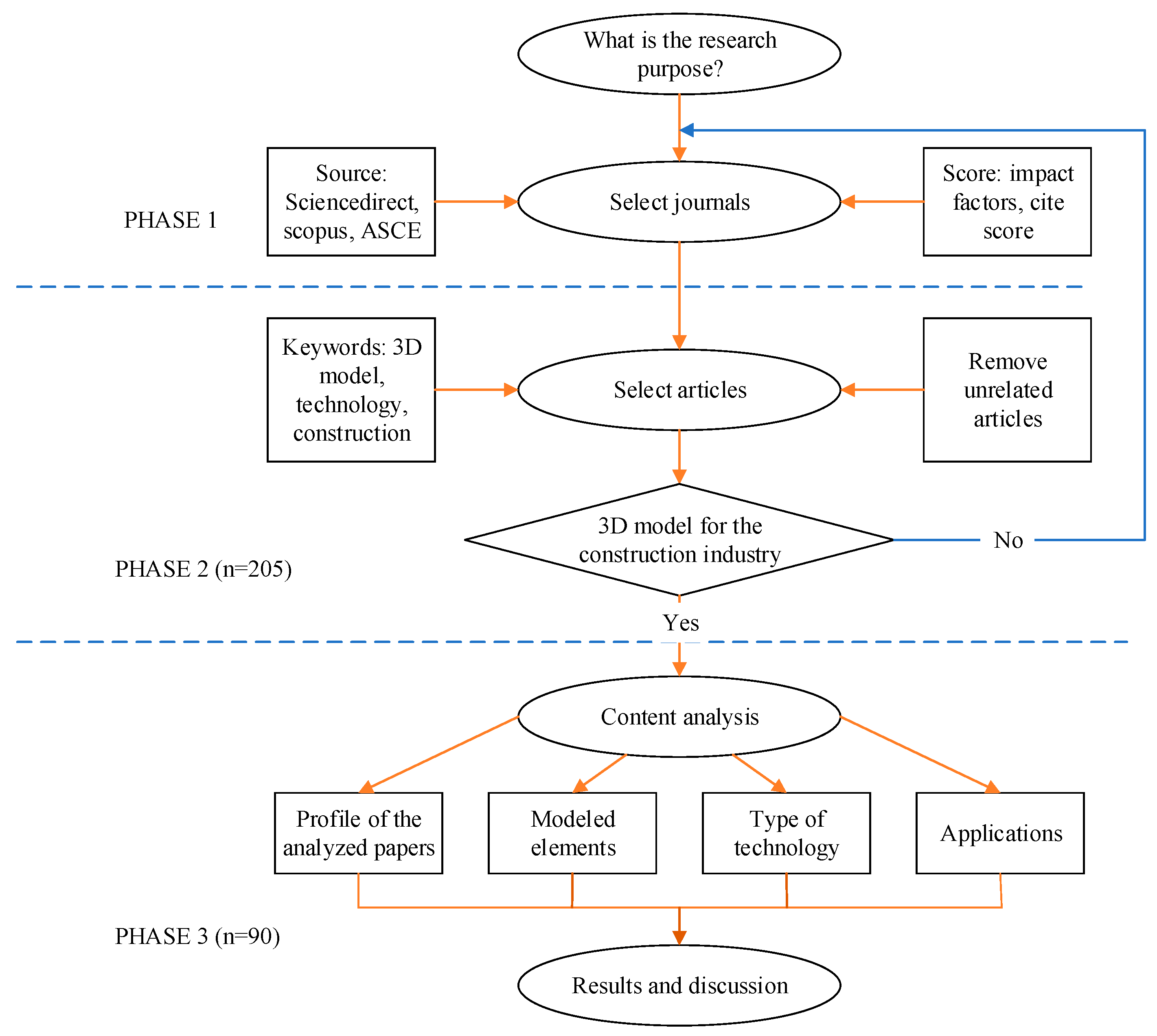
3. Research Method
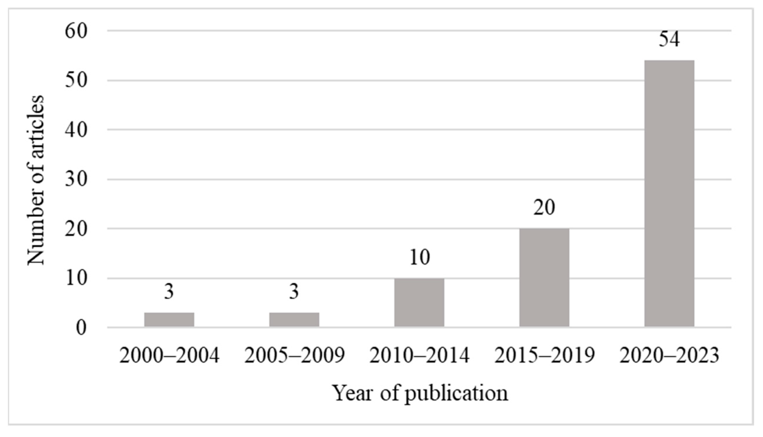
4. Profile of Selected Articles
5. Results and Discussion
5.1. Visualization and Image Modeling Technologies

| No. | Technology | Description and Typical Application | Key References | Number of References |
|---|---|---|---|---|
| 1 | BIM | BIM creates a shared digital model for a building or infrastructure project, which allows for a more efficient and accurate design and construction process, helps reduce errors, avoids conflicts, and generates accurate cost estimates and construction schedules. | [18,24,26,35,50,52,54,55,56,57,58] | 11 |
| 2 | Stereo vision system | A stereo camera may provide an entire field of view for 3D measurement in an unstructured and dynamic environment. It is widely used in different areas, including people tracking and mobile robotic navigation. | [59,60,61,62,63,64] | 6 |
| 3 | High-resolution satellite imagery | Satellite imagery is an essential tool for the visualization of urban planning, infrastructure, and disaster responses. | [65,66,67,68,69] | 5 |
| 4 | Photo processing programs | Photogrammetry has considerable value in cultural heritage applications because it enables accessibility through 3D modeling and expedites archaeological documentation. | [70,71,72,73,74] | 5 |
| 5 | Topological model | Topological models are mathematical models used in fields such as physics, computer science, and construction modeling to simplify the complexity of construction design and provide a more precise and intuitive visualization of the overall structure. | [75,76,77] | 3 |
| 6 | Mesh simplification | Mesh simplification is a modeling technique to reduce model complexity and decrease the amount of required memory for display. | [40,78,79] | 3 |
5.2. Geospatial Technologies
5.3. Algorithm-Based Technologies
5.4. Automated Technologies
| No. | Technology | Description and Typical Application | Key References | Number of References |
|---|---|---|---|---|
| 1 | Robots | The utilization of robots in construction is a growing trend that promises to revolutionize the field. Robots may be used to survey and map construction sites, increasing understanding of project progress and obstacles. | [6,9,86,114,130,137,140,141] | 8 |
| 2 | UAVs/UASs | UAVs are used widely in a range of industries for 3D modeling, including surveying, mapping, construction, and environmental monitoring, because of their advantages (e.g., reduced cost, increased safety, and high accuracy).UASs, commonly referred to as unmanned aerial systems, unmanned aerial vehicles, remotely piloted aircraft systems, and drones, benefit from 3D modeling processes. They may assess pre-project and project survey data, site inspection, surveillance, tracking, and management. | [33,46,109,143,144,145,146,147] | 8 |
5.5. Software for 3D Modeling
6. Conclusions
Author Contributions
Funding
Institutional Review Board Statement
Informed Consent Statement
Data Availability Statement
Conflicts of Interest
References
- Pan, Z.; Yu, Y.; Xiao, F.; Zhang, J. Recovering Building Information Model from 2D Drawings for Mechanical, Electrical and Plumbing Systems of Ageing Buildings. Autom. Constr. 2023, 152, 104914. [Google Scholar] [CrossRef]
- Zhao, Y.; Deng, X.; Lai, H. Reconstructing BIM from 2D Structural Drawings for Existing Buildings. Autom. Constr. 2021, 128, 103750. [Google Scholar] [CrossRef]
- Wen, R.; Tang, W.; Su, Z. Topology Based 2D Engineering Drawing and 3D Model Matching for Process Plant. Graph. Models 2017, 92, 1–15. [Google Scholar] [CrossRef]
- He, Y.; Yang, Y.; He, T.; Lai, Y.; He, Y.; Chen, B. Small and Micro-Water Quality Monitoring Based on the Integration of a Full-Space Real 3D Model and IoT. Sensors 2024, 24, 1033. [Google Scholar] [CrossRef] [PubMed]
- van Manen, M.; olde Scholtenhuis, L.; Voordijk, H. Empirically Validating Five Propositions Regarding 3D Visualizations for Subsurface Utility Projects. Eng. Constr. Archit. Manag. 2022, 29, 2535–2553. [Google Scholar] [CrossRef]
- Lin, J.J.; Ibrahim, A.; Sarwade, S.; Golparvar-Fard, M. Bridge Inspection with Aerial Robots: Automating the Entire Pipeline of Visual Data Capture, 3D Mapping, Defect Detection, Analysis, and Reporting. J. Comput. Civ. Eng. 2021, 35, 04020064. [Google Scholar] [CrossRef]
- Mohamed, M.; Tran, D.Q. Content Analysis of E-Inspection Implementation for Highway Infrastructure Construction Projects. Eng. Constr. Arch. Manag. 2022, 30, 2621–2644. [Google Scholar] [CrossRef]
- Mohamed, M.; Tran, D.Q. Risk-Based Inspection for Concrete Pavement Construction Using Fuzzy Sets and Bayesian Networks. Autom. Constr. 2021, 128, 103761. [Google Scholar] [CrossRef]
- Hou, S.; Dong, B.; Wang, H.; Wu, G. Inspection of Surface Defects on Stay Cables Using a Robot and Transfer Learning. Autom. Constr. 2020, 119, 103382. [Google Scholar] [CrossRef]
- Alavi, H.; Bortolini, R.; Forcada, N. BIM-Based Decision Support for Building Condition Assessment. Autom. Constr. 2022, 135, 104117. [Google Scholar] [CrossRef]
- Garcia-Gago, J.; Sánchez-Aparicio, L.J.; Soilán, M.; González-Aguilera, D. HBIM for Supporting the Diagnosis of Historical Buildings: Case Study of the Master Gate of San Francisco in Portugal. Autom. Constr. 2022, 141, 104453. [Google Scholar] [CrossRef]
- Resende, M.M.; Gambare, E.B.; Silva, L.A.; Cordeiro, Y.D.S.; Almeida, E.; Salvador, R.P. Infrared Thermal Imaging to Inspect Pathologies on Façades of Historical Buildings: A Case Study on the Municipal Market of São Paulo, Brazil. Case Stud. Constr. Mater. 2022, 16, e01122. [Google Scholar] [CrossRef]
- Abdirad, H.; Mathur, P. Artificial Intelligence for BIM Content Management and Delivery: Case Study of Association Rule Mining for Construction Detailing. Adv. Eng. Inform. 2021, 50, 101414. [Google Scholar] [CrossRef]
- Chen, H.; Hou, L.; Zhang, G.K.; Moon, S. Development of BIM, IoT and AR/VR Technologies for Fire Safety and Upskilling. Autom. Constr. 2021, 125, 103631. [Google Scholar] [CrossRef]
- Park, J.; Cai, H.; Dunston, P.S.; Ghasemkhani, H. Database-Supported and Web-Based Visualization for Daily 4D BIM. J. Constr. Eng. Manag. 2017, 143, 04017078. [Google Scholar] [CrossRef]
- Siebelink, S.; Voordijk, J.T.; Adriaanse, A. Developing and Testing a Tool to Evaluate BIM Maturity: Sectoral Analysis in the Dutch Construction Industry. J. Constr. Eng. Manag. 2018, 144, 05018007. [Google Scholar] [CrossRef]
- Vignali, V.; Acerra, E.M.; Lantieri, C.; Di Vincenzo, F.; Piacentini, G.; Pancaldi, S. Building Information Modelling (BIM) Application for an Existing Road Infrastructure. Autom. Constr. 2021, 128, 103752. [Google Scholar] [CrossRef]
- Alirezaei, S.; Taghaddos, H.; Ghorab, K.; Tak, A.N.; Alirezaei, S. BIM-Augmented Reality Integrated Approach to Risk Management. Autom. Constr. 2022, 141, 104458. [Google Scholar] [CrossRef]
- Panya, D.S.; Kim, T.; Choo, S. An Interactive Design Change Methodology Using a BIM-Based Virtual Reality and Augmented Reality. J. Build. Eng. 2023, 68, 106030. [Google Scholar] [CrossRef]
- Dino, I.G.; Sari, A.E.; Iseri, O.K.; Akin, S.; Kalfaoglu, E.; Erdogan, B.; Kalkan, S.; Alatan, A.A. Image-Based Construction of Building Energy Models Using Computer Vision. Autom. Constr. 2020, 116, 103231. [Google Scholar] [CrossRef]
- Valero, E.; Adán, A.; Bosché, F. Semantic 3D Reconstruction of Furnished Interiors Using Laser Scanning and RFID Technology. J. Comput. Civ. Eng. 2016, 30, 04015053. [Google Scholar] [CrossRef]
- Jiang, Y.; Yang, G.; Li, H.; Zhang, T. Knowledge Driven Approach for Smart Bridge Maintenance Using Big Data Mining. Autom. Constr. 2023, 146, 104673. [Google Scholar] [CrossRef]
- Tran, D.; Harper, C.; Sturgill, R.; National Cooperative Highway Research Program; Transportation Research Board. National Academies of Sciences, Engineering, and Medicine. In Highway Infrastructure Inspection Practices for the Digital Age; Transportation Research Board: Washington, DC, USA, 2022; p. 26592. ISBN 978-0-309-68939-7. [Google Scholar]
- Lee, S.; Yu, J.; Jeong, D. BIM Acceptance Model in Construction Organizations. J. Manag. Eng. 2015, 31, 04014048. [Google Scholar] [CrossRef]
- Benjaoran, V.; Bhokha, S. Enhancing Visualization of 4D CAD Model Compared to Conventional Methods. Eng. Constr. Archit. Manag. 2009, 16, 392–408. [Google Scholar] [CrossRef]
- Chen, Y.-J.; Lai, Y.-S.; Lin, Y.-H. BIM-Based Augmented Reality Inspection and Maintenance of Fire Safety Equipment. Autom. Constr. 2020, 110, 103041. [Google Scholar] [CrossRef]
- Taylor, T.; Sturgill, R.; Waddle, S.; Li, Y.; Goodrum, P.; Molenaar, K.; Al-Haddad, S. Workforce Optimization Workbook for Transportation Construction Projects; Transportation Research Board: Washington, DC, USA, 2020; p. 25720. ISBN 978-0-309-67331-0. [Google Scholar]
- Siraj, N.B.; Fayek, A.R. Risk Identification and Common Risks in Construction: Literature Review and Content Analysis. J. Constr. Eng. Manag. 2019, 145, 03119004. [Google Scholar] [CrossRef]
- Kazmi, H.; Fu, C.; Miller, C. Ten Questions Concerning Data-Driven Modelling and Forecasting of Operational Energy Demand at Building and Urban Scale. Build. Environ. 2023, 293, 110407. [Google Scholar] [CrossRef]
- Martínez-Rocamora, A.; García-Alvarado, R.; Casanova-Medina, E.; González-Böhme, L.F.; Auat-Cheein, F. Parametric Programming of 3D Printed Curved Walls for Cost-Efficient Building Design. J. Constr. Eng. Manag. 2020, 146, 04020039. [Google Scholar] [CrossRef]
- Nepal, M.P.; Staub-French, S.; Pottinger, R.; Zhang, J. Ontology-Based Feature Modeling for Construction Information Extraction from a Building Information Model. J. Comput. Civ. Eng. 2013, 27, 555–569. [Google Scholar] [CrossRef]
- Fekete, A.; Cserep, M. Tree Segmentation and Change Detection of Large Urban Areas Based on Airborne LiDAR. Comput. Geosci. 2021, 156, 104900. [Google Scholar] [CrossRef]
- Zheng, X.; Wang, F.; Li, Z. A Multi-UAV Cooperative Route Planning Methodology for 3D Fine-Resolution Building Model Reconstruction. ISPRS J. Photogramm. Remote Sens. 2018, 146, 483–494. [Google Scholar] [CrossRef]
- Bosché, F. Plane-Based Registration of Construction Laser Scans with 3D/4D Building Models. Adv. Eng. Inform. 2012, 26, 90–102. [Google Scholar] [CrossRef]
- Chen, K.; Lu, W.; Xue, F.; Tang, P.; Li, L.H. Automatic Building Information Model Reconstruction in High-Density Urban Areas: Augmenting Multi-Source Data with Architectural Knowledge. Autom. Constr. 2018, 93, 22–34. [Google Scholar] [CrossRef]
- Pang, H.E.; Biljecki, F. 3D Building Reconstruction from Single Street View Images Using Deep Learning. Int. J. Appl. Earth Obs. Geoinf. 2022, 112, 102859. [Google Scholar] [CrossRef]
- Xu, Y.; Shen, X.; Lim, S. CorDet: Corner-Aware 3D Object Detection Networks for Automated Scan-to-BIM. J. Comput. Civ. Eng. 2021, 35, 04021002. [Google Scholar] [CrossRef]
- Lombardi, F.; Lualdi, M.; Garavaglia, E. Masonry Texture Reconstruction for Building Seismic Assessment: Practical Evaluation and Potentials of Ground Penetrating Radar Methodology. Constr. Build. Mater. 2021, 299, 124189. [Google Scholar] [CrossRef]
- Xiao, Y.; Tutumluer, E. Gradation and Packing Characteristics Affecting Stability of Granular Materials: Aggregate Imaging-Based Discrete Element Modeling Approach. Int. J. Geomech. 2017, 17, 04016064. [Google Scholar] [CrossRef]
- Fahim, G.; Amin, K.; Zarif, S. Enhancing Single-View 3D Mesh Reconstruction with the Aid of Implicit Surface Learning. Image Vis. Comput. 2022, 119, 104377. [Google Scholar] [CrossRef]
- Chen, H.-M.; Huang, P.-H. 3D AR-Based Modeling for Discrete-Event Simulation of Transport Operations in Construction. Autom. Constr. 2013, 33, 123–136. [Google Scholar] [CrossRef]
- Mirzaei, A.; Nasirzadeh, F.; Parchami Jalal, M.; Zamani, Y. 4D-BIM Dynamic Time–Space Conflict Detection and Quantification System for Building Construction Projects. J. Constr. Eng. Manag. 2018, 144, 04018056. [Google Scholar] [CrossRef]
- Pikas, E.; Sacks, R.; Hazzan, O. Building Information Modeling Education for Construction Engineering and Management. II: Procedures and Implementation Case Study. J. Constr. Eng. Manag. 2013, 139, 05013002. [Google Scholar] [CrossRef]
- Gharaibeh, L.; Matarneh, S.; Eriksson, K.; Lantz, B. Digital Transformation of the Wood Construction Supply Chain through Building Information Modelling: Current State of Practice. Constr. Innov. 2023, 24, 273–291. [Google Scholar] [CrossRef]
- Ullah, K.; Lill, I.; Witt, E. An overview of BIM adoption in the construction industry: Benefits and barriers. In Emerald Reach Proceedings Series; Lill, I., Witt, E., Eds.; Emerald Publishing Limited: Bingley, UK, 2019; pp. 297–303. ISBN 978-1-83867-051-1. [Google Scholar]
- Tan, Y.; Li, S.; Liu, H.; Chen, P.; Zhou, Z. Automatic Inspection Data Collection of Building Surface Based on BIM and UAV. Autom. Constr. 2021, 131, 103881. [Google Scholar] [CrossRef]
- Tang, S.; Li, X.; Zheng, X.; Wu, B.; Wang, W.; Zhang, Y. BIM Generation from 3D Point Clouds by Combining 3D Deep Learning and Improved Morphological Approach. Autom. Constr. 2022, 141, 104422. [Google Scholar] [CrossRef]
- Tsai, Y.-H.; Wang, J.; Chien, W.-T.; Wei, C.-Y.; Wang, X.; Hsieh, S.-H. A BIM-Based Approach for Predicting Corrosion under Insulation. Autom. Constr. 2019, 107, 102923. [Google Scholar] [CrossRef]
- Inzerillo, L.; Di Mino, G.; Roberts, R. Image-Based 3D Reconstruction Using Traditional and UAV Datasets for Analysis of Road Pavement Distress. Autom. Constr. 2018, 96, 457–469. [Google Scholar] [CrossRef]
- Zhao, S.; Kang, F.; Li, J.; Ma, C. Structural Health Monitoring and Inspection of Dams Based on UAV Photogrammetry with Image 3D Reconstruction. Autom. Constr. 2021, 130, 103832. [Google Scholar] [CrossRef]
- Chen, S.-H.; Xue, F. Automatic BIM Detailing Using Deep Features of 3D Views. Autom. Constr. 2023, 148, 104780. [Google Scholar] [CrossRef]
- Huang, M.Q.; Ninić, J.; Zhang, Q.B. BIM, Machine Learning and Computer Vision Techniques in Underground Construction: Current Status and Future Perspectives. Tunn. Undergr. Space Technol. 2021, 108, 103677. [Google Scholar] [CrossRef]
- Zhang, S.; Teizer, J.; Lee, J.-K.; Eastman, C.M.; Venugopal, M. Building Information Modeling (BIM) and Safety: Automatic Safety Checking of Construction Models and Schedules. Autom. Constr. 2013, 29, 183–195. [Google Scholar] [CrossRef]
- Anane, W.; Iordanova, I.; Ouellet-Plamondon, C. BIM-Driven Computational Design for Robotic Manufacturing in off-Site Construction: An Integrated Design-to-Manufacturing (DtM) Approach. Autom. Constr. 2023, 150, 104782. [Google Scholar] [CrossRef]
- Bynum, P.; Issa, R.R.A.; Olbina, S. Building Information Modeling in Support of Sustainable Design and Construction. J. Constr. Eng. Manag. 2013, 139, 24–34. [Google Scholar] [CrossRef]
- Chen, J.; Lu, W.; Fu, Y.; Dong, Z. Automated Facility Inspection Using Robotics and BIM: A Knowledge-Driven Approach. Adv. Eng. Inform. 2023, 55, 101838. [Google Scholar] [CrossRef]
- Demirdöğen, G.; Işık, Z.; Arayici, Y. BIM-Based Big Data Analytic System for Healthcare Facility Management. J. Build. Eng. 2023, 64, 105713. [Google Scholar] [CrossRef]
- Herrera, R.F.; Mourgues, C.; Alarcón, L.F.; Pellicer, E. Analyzing the Association between Lean Design Management Practices and BIM Uses in the Design of Construction Projects. J. Constr. Eng. Manag. 2021, 147, 04021010. [Google Scholar] [CrossRef]
- Grifoni, E.; Legnaioli, S.; Nieri, P.; Campanella, B.; Lorenzetti, G.; Pagnotta, S.; Poggialini, F.; Palleschi, V. Construction and Comparison of 3D Multi-Source Multi-Band Models for Cultural Heritage Applications. J. Cult. Herit. 2018, 34, 261–267. [Google Scholar] [CrossRef]
- Hosseininaveh Ahmadabadian, A.; Karami, A.; Yazdan, R. An Automatic 3D Reconstruction System for Texture-Less Objects. Robot. Auton. Syst. 2019, 117, 29–39. [Google Scholar] [CrossRef]
- Hu, F.; Wang, F.; Ren, Y.; Xu, F.; Qiu, X.; Ding, C.; Jin, Y. Error Analysis and 3D Reconstruction Using Airborne Array InSAR Images. ISPRS J. Photogramm. Remote Sens. 2022, 190, 113–128. [Google Scholar] [CrossRef]
- Sung, C.; Kim, P.Y. 3D Terrain Reconstruction of Construction Sites Using a Stereo Camera. Autom. Constr. 2016, 64, 65–77. [Google Scholar] [CrossRef]
- Suveg, I.; Vosselman, G. Reconstruction of 3D Building Models from Aerial Images and Maps. ISPRS J. Photogramm. Remote Sens. 2004, 58, 202–224. [Google Scholar] [CrossRef]
- Elhashash, M.; Qin, R. Cross-View SLAM Solver: Global Pose Estimation of Monocular Ground-Level Video Frames for 3D Reconstruction Using a Reference 3D Model from Satellite Images. ISPRS J. Photogramm. Remote Sens. 2022, 188, 62–74. [Google Scholar] [CrossRef]
- Gao, J.; Liu, J.; Ji, S. A General Deep Learning Based Framework for 3D Reconstruction from Multi-View Stereo Satellite Images. ISPRS J. Photogramm. Remote Sens. 2023, 195, 446–461. [Google Scholar] [CrossRef]
- Nettis, A.; Massimi, V.; Nutricato, R.; Nitti, D.O.; Samarelli, S.; Uva, G. Satellite-Based Interferometry for Monitoring Structural Deformations of Bridge Portfolios. Autom. Constr. 2023, 147, 104707. [Google Scholar] [CrossRef]
- Stucker, C.; Schindler, K. ResDepth: A Deep Residual Prior for 3D Reconstruction from High-Resolution Satellite Images. ISPRS J. Photogramm. Remote Sens. 2022, 183, 560–580. [Google Scholar] [CrossRef]
- Awrangjeb, M.; Zhang, C.; Fraser, C.S. Automatic Extraction of Building Roofs Using LIDAR Data and Multispectral Imagery. ISPRS J. Photogramm. Remote Sens. 2013, 83, 1–18. [Google Scholar] [CrossRef]
- Golparvar-Fard, M.; Peña-Mora, F.; Savarese, S. Automated Progress Monitoring Using Unordered Daily Construction Photographs and IFC-Based Building Information Models. J. Comput. Civ. Eng. 2015, 29, 04014025. [Google Scholar] [CrossRef]
- Hu, Y.; Chen, X.; Tang, Z.; Yu, J.; Chen, Y.; Wu, Z.; Yang, D.; Chen, Y. Collaborative 3D Real Modeling by Multi-View Images Photogrammetry and Laser Scanning: The Case Study of Tangwei Village, China. Digit. Appl. Archaeol. Cult. Herit. 2021, 21, e00185. [Google Scholar] [CrossRef]
- Kingsland, K. Comparative Analysis of Digital Photogrammetry Software for Cultural Heritage. Digit. Appl. Archaeol. Cult. Herit. 2020, 18, e00157. [Google Scholar] [CrossRef]
- Zheng, Q.; Shi, B.; Pan, G. Summary Study of Data-Driven Photometric Stereo Methods. Virtual Real. Intell. Hardw. 2020, 2, 213–221. [Google Scholar] [CrossRef]
- Shi, B.; Mo, Z.; Wu, Z.; Duan, D.; Yeung, S.-K.; Tan, P. A Benchmark Dataset and Evaluation for Non-Lambertian and Uncalibrated Photometric Stereo. IEEE Trans. Pattern Anal. Mach. Intell. 2019, 41, 271–284. [Google Scholar] [CrossRef]
- Ju, Y.; Lam, K.-M.; Xie, W.; Zhou, H.; Dong, J.; Shi, B. Deep Learning Methods for Calibrated Photometric Stereo and Beyond. IEEE Trans. Pattern Anal. Mach. Intell. 2024, 1–19. [Google Scholar] [CrossRef]
- Horna, S.; Meneveaux, D.; Damiand, G.; Bertrand, Y. Consistency Constraints and 3D Building Reconstruction. Comput. Aided Des. 2009, 41, 13–27. [Google Scholar] [CrossRef]
- Khalili, A.; Chua, D.K.H. IFC-Based Graph Data Model for Topological Queries on Building Elements. J. Comput. Civ. Eng. 2015, 29, 04014046. [Google Scholar] [CrossRef]
- Yang, S.; Cai, G.; Du, J.; Chen, P.; Su, J.; Wu, Y.; Wang, Z.; Li, J. Connectivity-Aware Graph: A Planar Topology for 3D Building Surface Reconstruction. ISPRS J. Photogramm. Remote Sens. 2022, 191, 302–314. [Google Scholar] [CrossRef]
- Li, M.; Nan, L. Feature-Preserving 3D Mesh Simplification for Urban Buildings. ISPRS J. Photogramm. Remote Sens. 2021, 173, 135–150. [Google Scholar] [CrossRef]
- Zhang, S.; Zhan, Y.; Cui, X.; Gao, M.; Huang, J.; Metaxas, D. 3D Anatomical Shape Atlas Construction Using Mesh Quality Preserved Deformable Models. Comput. Vis. Image Underst. 2013, 117, 1061–1071. [Google Scholar] [CrossRef]
- Wang, B.; Wang, Q.; Cheng, J.C.P.; Song, C.; Yin, C. Vision-Assisted BIM Reconstruction from 3D LiDAR Point Clouds for MEP Scenes. Autom. Constr. 2022, 133, 103997. [Google Scholar] [CrossRef]
- Deng, Y.; Cheng, J.C.P.; Anumba, C. Mapping between BIM and 3D GIS in Different Levels of Detail Using Schema Mediation and Instance Comparison. Autom. Constr. 2016, 67, 1–21. [Google Scholar] [CrossRef]
- Davila Delgado, J.M.; Oyedele, L.; Demian, P.; Beach, T. A Research Agenda for Augmented and Virtual Reality in Architecture, Engineering and Construction. Adv. Eng. Inform. 2020, 45, 101122. [Google Scholar] [CrossRef]
- Osorto Carrasco, M.D.; Chen, P.-H. Application of Mixed Reality for Improving Architectural Design Comprehension Effectiveness. Autom. Constr. 2021, 126, 103677. [Google Scholar] [CrossRef]
- Yin, Y.; Antonio, J. Application of 3D Laser Scanning Technology for Image Data Processing in the Protection of Ancient Building Sites through Deep Learning. Image Vis. Comput. 2020, 102, 103969. [Google Scholar] [CrossRef]
- Yu, D.; Ji, S.; Liu, J.; Wei, S. Automatic 3D Building Reconstruction from Multi-View Aerial Images with Deep Learning. ISPRS J. Photogramm. Remote Sens. 2021, 171, 155–170. [Google Scholar] [CrossRef]
- Trzeciak, M.; Brilakis, I. Dense 3D Reconstruction of Building Scenes by AI-Based Camera–Lidar Fusion and Odometry. J. Comput. Civ. Eng. 2023, 37, 04023010. [Google Scholar] [CrossRef]
- Einhorn, E.; Schröter, C.; Gross, H.M. Attention-Driven Monocular Scene Reconstruction for Obstacle Detection, Robot Navigation and Map Building. Robot. Auton. Syst. 2011, 59, 296–309. [Google Scholar] [CrossRef]
- Nikoohemat, S.; Diakité, A.A.; Zlatanova, S.; Vosselman, G. Indoor 3D Reconstruction from Point Clouds for Optimal Routing in Complex Buildings to Support Disaster Management. Autom. Constr. 2020, 113, 103109. [Google Scholar] [CrossRef]
- Tian, Y.; Gerke, M.; Vosselman, G.; Zhu, Q. Knowledge-Based Building Reconstruction from Terrestrial Video Sequences. ISPRS J. Photogramm. Remote Sens. 2010, 65, 395–408. [Google Scholar] [CrossRef]
- Mallela, J.; Mitchell, A.; Gustafson, J.; Olsen, M.J.; Parrish, C.; Gillins, D.T.; Kumpula, M.; Roe, G. Effective Use of Geospatial Tools in Highway Construction; Report No. FHWA-HIF-19-089; Federal Highway Administration: Washington, DC, USA, 2018.
- Jung, J.; Sohn, G. A Line-Based Progressive Refinement of 3D Rooftop Models Using Airborne LiDAR Data with Single View Imagery. ISPRS J. Photogramm. Remote Sens. 2019, 149, 157–175. [Google Scholar] [CrossRef]
- Cheng, L.; Tong, L.; Chen, Y.; Zhang, W.; Shan, J.; Liu, Y.; Li, M. Integration of LiDAR Data and Optical Multi-View Images for 3D Reconstruction of Building Roofs. Opt. Lasers Eng. 2013, 51, 493–502. [Google Scholar] [CrossRef]
- Wu, Q.; Yang, H.; Wei, M.; Remil, O.; Wang, B.; Wang, J. Automatic 3D Reconstruction of Electrical Substation Scene from LiDAR Point Cloud. ISPRS J. Photogramm. Remote Sens. 2018, 143, 57–71. [Google Scholar] [CrossRef]
- Catharia, O.; Richard, F.; Vignoles, H.; Véron, P.; Aoussat, A.; Segonds, F. Smartphone LiDAR Data: A Case Study for Numerisation of Indoor Buildings in Railway Stations. Sensors 2023, 23, 1967. [Google Scholar] [CrossRef]
- Asadi, K.; Haritsa, V.R.; Han, K.; Ore, J.-P. Automated Object Manipulation Using Vision-Based Mobile Robotic System for Construction Applications. J. Comput. Civ. Eng. 2021, 35, 04020058. [Google Scholar] [CrossRef]
- Carter-Greaves, L.E.; Eyre, M.; Vogt, D.; Coggan, J. Algorithm Development for Automated Key Block Analysis in Tunnels from LiDAR Point Cloud Data. Tunn. Undergr. Space Technol. 2023, 132, 104787. [Google Scholar] [CrossRef]
- Huang, H.; Brenner, C.; Sester, M. A Generative Statistical Approach to Automatic 3D Building Roof Reconstruction from Laser Scanning Data. ISPRS J. Photogramm. Remote Sens. 2013, 79, 29–43. [Google Scholar] [CrossRef]
- Cheng, L.; Yuan, Y.; Xia, N.; Chen, S.; Chen, Y.; Yang, K.; Ma, L.; Li, M. Crowd-Sourced Pictures Geo-Localization Method Based on Street View Images and 3D Reconstruction. ISPRS J. Photogramm. Remote Sens 2018, 141, 72–85. [Google Scholar] [CrossRef]
- Avdan, U.; Kaplan, G.; Küçük Matcı, D.; Yiğit Avdan, Z.; Erdem, F.; Tuğba Mızık, E.; Demirtaş, İ. Soil Salinity Prediction Models Constructed by Different Remote Sensors. Phys. Chem. Earth Parts A/B/C 2022, 128, 103230. [Google Scholar] [CrossRef]
- Ahmed, H.; La, H.M.; Tran, K. Rebar Detection and Localization for Bridge Deck Inspection and Evaluation Using Deep Residual Networks. Autom. Constr. 2020, 120, 103393. [Google Scholar] [CrossRef]
- Calhoon, T.; Zegeye, E.; Velasquez, R.; Calvert, J. Using Falling Weight Deflectometer (FWD) and Ground Penetrating Radar (GPR) to Monitor the Effects of Seasonal Moisture Variation on the Structural Capacity of Pavements. Constr. Build. Mater. 2022, 351, 128831. [Google Scholar] [CrossRef]
- Khamzin, A.K.; Varnavina, A.V.; Torgashov, E.V.; Anderson, N.L.; Sneed, L.H. Utilization of Air-Launched Ground Penetrating Radar (GPR) for Pavement Condition Assessment. Constr. Build. Mater. 2017, 141, 130–139. [Google Scholar] [CrossRef]
- Deng, Y.; Gan, V.J.L.; Das, M.; Cheng, J.C.P.; Anumba, C. Integrating 4D BIM and GIS for Construction Supply Chain Management. J. Constr. Eng. Manag. 2019, 145, 04019016. [Google Scholar] [CrossRef]
- Sánchez-Aparicio, L.J.; Masciotta, M.-G.; García-Alvarez, J.; Ramos, L.F.; Oliveira, D.V.; Martín-Jiménez, J.A.; González-Aguilera, D.; Monteiro, P. Web-GIS Approach to Preventive Conservation of Heritage Buildings. Autom. Constr. 2020, 118, 103304. [Google Scholar] [CrossRef]
- Garbett, J.; Hartley, T.; Heesom, D. A Multi-User Collaborative BIM-AR System to Support Design and Construction. Autom. Constr. 2021, 122, 103487. [Google Scholar] [CrossRef]
- Cai, H.; Andoh, A.R.; Su, X.; Li, S. A Boundary Condition Based Algorithm for Locating Construction Site Objects Using RFID and GPS. Adv. Eng. Inform 2014, 28, 455–468. [Google Scholar] [CrossRef]
- Strach, M.; Dronszczyk, P. Comprehensive 3D Measurements of Tram Tracks in the Tunnel Using the Combination of Laser Scanning Technology and Traditional TPS/GPS Surveying. Transp. Res. Procedia 2016, 14, 1940–1949. [Google Scholar] [CrossRef]
- Domdouzis, K.; Kumar, B.; Anumba, C. Radio-Frequency Identification (RFID) Applications: A Brief Introduction. Adv. Eng. Inform. 2007, 21, 350–355. [Google Scholar] [CrossRef]
- Zhang, Y.; Bai, L. Rapid Structural Condition Assessment Using Radio Frequency Identification (RFID) Based Wireless Strain Sensor. Autom. Constr. 2015, 54, 1–11. [Google Scholar] [CrossRef]
- Park, J.; Im, S.; Lee, K.-H.; Lee, J.-O. Vision-Based SLAM System for Small UAVs in GPS-Denied Environments. J. Aerosp. Eng. 2012, 25, 519–529. [Google Scholar] [CrossRef]
- Zhang, S.; Hou, D.; Wang, C.; Pan, F.; Yan, L. Integrating and Managing BIM in 3D Web-Based GIS for Hydraulic and Hydropower Engineering Projects. Autom. Constr. 2020, 112, 103114. [Google Scholar] [CrossRef]
- Jiang, W.; Zhou, Y.; Ding, L.; Zhou, C.; Ning, X. UAV-Based 3D Reconstruction for Hoist Site Mapping and Layout Planning in Petrochemical Construction. Autom. Constr. 2020, 113, 103137. [Google Scholar] [CrossRef]
- Xu, Y.; Zhang, J. UAV-Based Bridge Geometric Shape Measurement Using Automatic Bridge Component Detection and Distributed Multi-View Reconstruction. Autom. Constr. 2022, 140, 104376. [Google Scholar] [CrossRef]
- Bosché, F. Automated Recognition of 3D CAD Model Objects in Laser Scans and Calculation of As-Built Dimensions for Dimensional Compliance Control in Construction. Adv. Eng. Inform. 2010, 24, 107–118. [Google Scholar] [CrossRef]
- Surmann, H.; Nüchter, A.; Hertzberg, J. An Autonomous Mobile Robot with a 3D Laser Range Finder for 3D Exploration and Digitalization of Indoor Environments. Robot. Auton. Syst. 2003, 45, 181–198. [Google Scholar] [CrossRef]
- Dawood, T.; Zhu, Z.; Zayed, T. Machine Vision-Based Model for Spalling Detection and Quantification in Subway Networks. Autom. Constr. 2017, 81, 149–160. [Google Scholar] [CrossRef]
- Kardovskyi, Y.; Moon, S. Artificial Intelligence Quality Inspection of Steel Bars Installation by Integrating Mask R-CNN and Stereo Vision. Autom. Constr. 2021, 130, 103850. [Google Scholar] [CrossRef]
- Wang, X.; Dunston, P.S. Potential of Augmented Reality as an Assistant Viewer for Computer-Aided Drawing. J. Comput. Civ. Eng. 2006, 20, 437–441. [Google Scholar] [CrossRef]
- Harper, C.; Tran, D.; Jaselskis, E.; National Cooperative Highway Research Program; National Cooperative Highway Research Program Synthesis Program; Synthesis Program; Transportation Research Board. National Academies of Sciences, Engineering, and Medicine. In Emerging Technologies for Construction Delivery; Transportation Research Board: Washington, DC, USA, 2019; p. 25540. ISBN 978-0-309-48046-8. [Google Scholar]
- Yang, X.; Guan, J.; Ding, L.; You, Z.; Lee, V.C.S.; Mohd Hasan, M.R.; Cheng, X. Research and Applications of Artificial Neural Network in Pavement Engineering: A State-of-the-Art Review. J. Traffic Transp. Eng. Engl. Ed. 2021, 8, 1000–1021. [Google Scholar] [CrossRef]
- Choi, S.H.; Kim, M.; Lee, J.Y. Situation-Dependent Remote AR Collaborations: Image-Based Collaboration Using a 3D Perspective Map and Live Video-Based Collaboration with a Synchronized VR Mode. Comput. Ind. 2018, 101, 51–66. [Google Scholar] [CrossRef]
- Harikrishnan, A.; Said Abdallah, A.; Ayer, S.K.; El Asmar, M.; Tang, P. Feasibility of Augmented Reality Technology for Communication in the Construction Industry. Adv. Eng. Inform. 2021, 50, 101363. [Google Scholar] [CrossRef]
- Trappey, A.J.C.; Trappey, C.V.; Chao, M.-H.; Wu, C.-T. VR-Enabled Engineering Consultation Chatbot for Integrated and Intelligent Manufacturing Services. J. Ind. Inf. Integr. 2022, 26, 100331. [Google Scholar] [CrossRef]
- Manuel Davila Delgado, J.; Oyedele, L. Robotics in Construction: A Critical Review of the Reinforcement Learning and Imitation Learning Paradigms. Adv. Eng. Inform. 2022, 54, 101787. [Google Scholar] [CrossRef]
- Pantoja-Rosero, B.G.; Achanta, R.; Kozinski, M.; Fua, P.; Perez-Cruz, F.; Beyer, K. Generating LOD3 Building Models from Structure-from-Motion and Semantic Segmentation. Autom. Constr. 2022, 141, 104430. [Google Scholar] [CrossRef]
- Wei, S.; Luo, M.; Zhu, L.; Yang, Z. Using Object-Oriented Coupled Deep Learning Approach for Typical Object Inspection of Transmission Channel. Int. J. Appl. Earth Obs. Geoinf 2023, 116, 103137. [Google Scholar] [CrossRef]
- Wang, T.; Gan, V.J.L. Automated Joint 3D Reconstruction and Visual Inspection for Buildings Using Computer Vision and Transfer Learning. Autom. Constr. 2023, 149, 104810. [Google Scholar] [CrossRef]
- Chen, P.-Y.; Wu, Z.Y.; Taciroglu, E. Classification of Soft-Story Buildings Using Deep Learning with Density Features Extracted from 3D Point Clouds. J. Comput. Civ. Eng. 2021, 35, 04021005. [Google Scholar] [CrossRef]
- Wang, W.; Gao, W.; Cui, H.; Hu, Z. Reconstruction of Lines and Planes of Urban Buildings with Angle Regularization. ISPRS J. Photogramm. Remote Sens. 2020, 165, 54–66. [Google Scholar] [CrossRef]
- Zhao, X.; Cheah, C.C. BIM-Based Indoor Mobile Robot Initialization for Construction Automation Using Object Detection. Autom. Constr. 2023, 146, 104647. [Google Scholar] [CrossRef]
- Dan, H.-C.; Bai, G.-W.; Zhu, Z.-H.; Liu, X.; Cao, W. An Improved Computation Method for Asphalt Pavement Texture Depth Based on Multiocular Vision 3D Reconstruction Technology. Constr. Build. Mater. 2022, 321, 126427. [Google Scholar] [CrossRef]
- Ibrahim, A.; Golparvar-Fard, M.; El-Rayes, K. Multiobjective Optimization of Reality Capture Plans for Computer Vision–Driven Construction Monitoring with Camera-Equipped UAVs. J. Comput. Civ. Eng. 2022, 36, 04022018. [Google Scholar] [CrossRef]
- Jarząbek-Rychard, M.; Borkowski, A. 3D Building Reconstruction from ALS Data Using Unambiguous Decomposition into Elementary Structures. ISPRS J. Photogramm. Remote Sens. 2016, 118, 1–12. [Google Scholar] [CrossRef]
- Chung, W.-Y.; Lee, B.G.; Yang, C.S. 3D Virtual Viewer on Mobile Device for Wireless Sensor Network-Based RSSI Indoor Tracking System. Sens. Actuators B Chem. 2009, 140, 35–42. [Google Scholar] [CrossRef]
- Over, M.; Schilling, A.; Neubauer, S.; Zipf, A. Generating Web-Based 3D City Models from OpenStreetMap: The Current Situation in Germany. Comput. Environ. Urban Syst. 2010, 34, 496–507. [Google Scholar] [CrossRef]
- Qin, R.; Feng, B.; Xu, Z.; Zhou, Y.; Liu, L.; Li, Y. Web-Based 3D Visualization Framework for Time-Varying and Large-Volume Oceanic Forecasting Data Using Open-Source Technologies. Environ. Model. Softw. 2021, 135, 104908. [Google Scholar] [CrossRef]
- Kim, J.; Chung, D.; Kim, Y.; Kim, H. Deep Learning-Based 3D Reconstruction of Scaffolds Using a Robot Dog. Autom. Constr. 2022, 134, 104092. [Google Scholar] [CrossRef]
- Bolourian, N.; Hammad, A. LiDAR-Equipped UAV Path Planning Considering Potential Locations of Defects for Bridge Inspection. Autom. Constr. 2020, 117, 103250. [Google Scholar] [CrossRef]
- Colvalkar, A.; Pawar, S.S.; Patle, B.K. In-Pipe Inspection Robotic System for Defect Detection and Identification Using Image Processing. Mater. Today Proc. 2023, 72, 1735–1742. [Google Scholar] [CrossRef]
- Halder, S.; Afsari, K.; Chiou, E.; Patrick, R.; Hamed, K.A. Construction Inspection & Monitoring with Quadruped Robots in Future Human-Robot Teaming: A Preliminary Study. J. Build. Eng. 2023, 65, 105814. [Google Scholar] [CrossRef]
- Le, N.; Tran, D.; Sturgill, R.; Harper, C. Exploring Remote Sensing and Monitoring Technology for Highway Infrastructure Inspection. Constr. Res. Congr. 2024, 2024, 406–415. [Google Scholar]
- Karim, M.M.; Dagli, C.H.; Qin, R. Modeling and Simulation of a Robotic Bridge Inspection System. Procedia Comput. Sci. 2020, 168, 177–185. [Google Scholar] [CrossRef]
- Lei, B.; Wang, N.; Xu, P.; Song, G. New Crack Detection Method for Bridge Inspection Using UAV Incorporating Image Processing. J. Aerosp. Eng. 2018, 31, 879. [Google Scholar] [CrossRef]
- Liu, D.; Chen, J.; Hu, D.; Zhang, Z. Dynamic BIM-Augmented UAV Safety Inspection for Water Diversion Project. Comput. Ind. 2019, 108, 163–177. [Google Scholar] [CrossRef]
- Hamdan, A.-H.; Taraben, J.; Helmrich, M.; Mansperger, T.; Morgenthal, G.; Scherer, R.J. A Semantic Modeling Approach for the Automated Detection and Interpretation of Structural Damage. Autom. Constr. 2021, 128, 103739. [Google Scholar] [CrossRef]
- Mandirola, M.; Casarotti, C.; Peloso, S.; Lanese, I.; Brunesi, E.; Senaldi, I. Use of UAS for Damage Inspection and Assessment of Bridge Infrastructures. Int. J. Disaster Risk Reduct. 2022, 72, 102824. [Google Scholar] [CrossRef]
- Melo, R.R.S.D.; Costa, D.B.; Álvares, J.S.; Irizarry, J. Applicability of Unmanned Aerial System (UAS) for Safety Inspection on Construction Sites. Saf. Sci. 2017, 98, 174–185. [Google Scholar] [CrossRef]
- Messi, L.; García de Soto, B.; Carbonari, A.; Naticchia, B. Spatial Conflict Simulator Using Game Engine Technology and Bayesian Networks for Workspace Management. Autom. Constr. 2022, 144, 104596. [Google Scholar] [CrossRef]
- Mirhosseini, M.; Fazlali, M.; Tabatabaee Malazi, H.; Izadi, S.K.; Nezamabadi-pour, H. Parallel Quadri-Valent Quantum-Inspired Gravitational Search Algorithm on a Heterogeneous Platform for Wireless Sensor Networks. Comput. Electr. Eng. 2021, 92, 107085. [Google Scholar] [CrossRef]
- Monji-Azad, S.; Kinz, M.; Hesser, J.; Löw, N. SimTool: A Toolset for Soft Body Simulation Using Flex and Unreal Engine. Softw. Impacts 2023, 17, 100521. [Google Scholar] [CrossRef]
- Svensgaard, J.; Jensen, S.M.; Christensen, S.; Rasmussen, J. The Importance of Spectral Correction of UAV-Based Phenotyping with RGB Cameras. Field Crops Res. 2021, 269, 108177. [Google Scholar] [CrossRef]
| No. | Journals | Number of Articles | Proportions of Analyzed Articles | CiteScore | Impact Factor | |
|---|---|---|---|---|---|---|
| Selected | Analyzed | |||||
| 1 | Automation in Construction | 74 | 29 | 32.2 | 15.0 | 10.50 |
| 2 | International Journal of Photogrammetry and Remote Sensing | 33 | 16 | 17.8 | 17.6 | 11.77 |
| 3 | Journal of Computing in Civil Engineering (JCCE) | 26 | 9 | 10.0 | 7.6 | 10.00 |
| 4 | Journal of Construction Engineering and Management (JCEM) | 15 | 8 | 8.9 | 6.4 | 6.20 |
| 5 | Advanced Engineering Informatics (AEI) | 15 | 5 | 5.6 | 10.1 | 7.86 |
| 6 | Tunneling and Underground Space Technology (TUST) | 4 | 2 | 2.2 | 11.0 | 6.41 |
| 7 | Construction and Building Materials (CBM) | 4 | 1 | 1.1 | 10.6 | 7.69 |
| 8 | Robotics and Autonomous Systems (RAS) | 4 | 4 | 4.4 | 8.1 | 3.70 |
| 9 | Journal of Building Engineering (JOBE) | 4 | 2 | 2.2 | 5.5 | 5.60 |
| 10 | Digital Applications in Archaeology and Cultural Heritage (DAACH) | 3 | 1 | 1.1 | 5.0 | 3.47 |
| 11 | Journal of Bridge Engineering (JBE) | 3 | 1 | 1.1 | 6.4 | 7.14 |
| 12 | International Journal of Geomechanics (IJG) | 3 | 1 | 1.1 | 6.3 | 3.93 |
| 13 | Journal of Management in Engineering (JME) | 3 | 2 | 2.2 | 7.9 | 9.00 |
| 14 | Computer-Aided Design (CAD) | 3 | 1 | 1.1 | 6.1 | 3.65 |
| 15 | Journal of Aerospace Engineering (JAE) | 2 | 2 | 2.2 | 3.5 | 2.24 |
| 16 | Image and Vision Computing (IVC) | 2 | 1 | 1.1 | 6.3 | 3.86 |
| 17 | International Journal of Applied Earth Observation and Geoinformation (IJAEOG) | 2 | 1 | 1.1 | 10.5 | 7.67 |
| 18 | Journal of Cultural Heritage (JCH) | 2 | 1 | 1.1 | 6.1 | 3.23 |
| 19 | Computers in Industry (CI) | 1 | 1 | 1.1 | 16.9 | 11.25 |
| 20 | Computers & Geosciences (CG) | 1 | 1 | 1.1 | 7.0 | 5.17 |
| 21 | Journal of Industrial Information Integration (JIII) | 1 | 1 | 1.1 | 20.9 | 11.72 |
| Total | 205 | 90 | 100 | |||
| No. | Technology | Frequency | Percentage of Identified Technologies (%) |
|---|---|---|---|
| 1 | BIM | 77 | 20.8 |
| 2 | Remote sensing | 71 | 19.1 |
| 3 | Stereo vision system/Photo processing programs | 57 | 15.4 |
| 4 | Augmented reality (AR)/Virtual reality (VR) | 34 | 9.2 |
| 5 | Deep learning, Reinforcement learning | 23 | 7.3 |
| 6 | Robots | 16 | 4.3 |
| 7 | Unmanned aerial vehicles (UAV)/Unmanned aircraft systems (UAS) | 15 | 4.0 |
| 8 | Topological model | 9 | 2.4 |
| 9 | Mesh simplification | 9 | 2.4 |
| 10 | Geographic information system (GIS)/Global positioning system (GPS) | 8 | 2.2 |
| 11 | Computer Vision | 6 | 1.6 |
| 12 | Finite element method | 5 | 1.3 |
| 13 | Web-based applications | 5 | 1.3 |
| 14 | Machine learning | 4 | 1.1 |
| 15 | Extended reality (ER) | 3 | 0.8 |
| 16 | Discrete element method | 2 | 0.5 |
| 17 | Others | 27 | 7.3 |
| Total | 371 | 100.0 |
| No. | Modeled Element | Description | Key References | Frequency (n = 205) | Percentage of Nodes (%) |
|---|---|---|---|---|---|
| 1 | Buildings | Three-dimensional models may illustrate a series of building sections: foundation, wall, rooftop, electricity system, ventilation system, room facilities | [26,30,31] | 134 | 48.0 |
| 2 | Street view, earth surface, and building blocks | Three-dimensional models can be used to model streets, tree segmentations, building blocks, and surfaces of unstructured areas | [32,33] | 45 | 16.1 |
| 3 | Urban planning (e.g., city and cultural heritage) | Three-dimensional models can include 3D city models and cultural heritage for tourism and conservation purposes | [34,35] | 34 | 12.2 |
| 4 | Infrastructure (e.g., tunnel, bridge, road, and dam) | Three-dimensional models may visualize, optimize, and validate for dams, tunnels, roads, bridge designs, and operations | [17] | 34 | 12.2 |
| 5 | Activity in construction | Three-dimensional building models are an established instance of geospatial information in built environments | [36,37] | 21 | 7.5 |
| 6 | Building materials (e.g., aggregate and sand) | Three-dimensional models are effective tools for modeling and controlling the material quality | [38,39] | 7 | 2.5 |
| 7 | Room facilities (e.g., chairs and tables) | Three-dimensional models can be used to visualize and enhance mesh construction for room facilities | [40] | 3 | 1.1 |
| 8 | Transportation operation | Three-dimensional models are used to visualize transport operations in construction | [41] | 1 | 0.4 |
| Total | 279 | 100.0 |
| No. | Technologies | Advantages | Limitations | Typical References |
|---|---|---|---|---|
| 1 | BIM | Covers various mechanical, electrical, and plumbing components Extracts accurate component module Clash detection May create an as-built model for facility management | Heavily relies on the excellent coverage of collected data Lacks sufficient legal framework | [24,80] |
| 2 | Stereo vision system/Photo processing programs | May capture depth information Less affected by light Provides immediate processing and response | Requires exact alignment Requires a complex computational processing | [68] |
| 3 | GIS/GPS | Streamlines the management of large blocks Improves interpretation of the inspection outcome Facilitates BIM applications Presents all types of geographical data | Loss of data during transformation Minimal level of detail harmonization during the mapping process Transformation of the local placement system to a world coordinate system | [81] |
| 4 | AR/VR | AR may produce safer working environments VR may support safety education Uses for life cycle assessment | Lack of awareness of the technology Poor usability Significant time commitment for implementation Lack of interoperability between BIM systems and AR/VR models | [82,83] |
| 5 | Deep learning, Reinforcement learning | High accuracy Automatically learns features from raw data May scale to handle large datasets | Requires large amounts of training data Requires significant computational resources Some models are difficult to interpret | [84,85,86] |
| 6 | Robot | Improves safety in inspection, survey Works faster and more consistently Reduces labor costs for investigating remote areas No need to suspend traffic during the cable inspection robot | Requires a high initial cost Requires regular maintenance and repair Introduces new safety concerns | [9,87] |
| 7 | Remote sensing | May generate an accurate spatial representation of buildings quickly | Time-consuming in some cases Provides point clouds (unstructured data) | [62,88] |
| No. | Technology | Description and Typical Application | Key References | Number of References |
|---|---|---|---|---|
| 1 | Remote sensing | Remote sensing data are typically collected using a variety of sensors, including visible and infrared cameras, radar, and light detecting and ranging. Remote sensing provides information about land usage, the earth’s surface, and infrastructure. | [32,68,84,87,95,96,97,98,99] | 9 |
| 2 | GPR | Benefits of using GPR for 3D modeling include improved site understanding, design, and construction in real-time. GPR data allow proper planning to avoid accidental damage to utilities during excavation. | [38,100,101,102] | 4 |
| 3 | GIS | GIS enhances visualization, improves decision-making and flexibility, and increases efficiency, scalability, and accessibility. Users may manipulate and analyze spatial data and create maps. | [63,81,103,104] | 4 |
| 4 | GPS | GPS is a satellite-based navigation system that provides location and time information to users worldwide. It beneficially allows accurate geolocation, spatial reference and scale, real-time tracking, and monitoring. | [105,106,107] | 3 |
| 5 | RFID | Using RFID in conjunction with computer-aided design (CAD), BIM, and other forms (GIS, GPS, and GPR) of 3D modeling may also strengthen jobsite management by reducing errors and rework. | [21,108,109] | 3 |
| No. | Technology | Description and Typical Application | Key References | Number of References |
|---|---|---|---|---|
| 1 | AR/VR | AR/VR has demonstrated powerful capabilities across multiple industries, including entertainment, manufacturing, and construction. | [14,19,41,50,81,117,121,122,123,124] | 10 |
| 2 | Deep learning, reinforcement learning | Deep learning is a subfield of machine learning that applies neural networks to recognize complex patterns and relationships in data for structural health monitoring, allowing users to detect anomalies and predict failures. It has become increasingly popular because of its capabilities in image and speech recognition and autonomous tools. | [36,65,119,125,126,127,128,129,130] | 9 |
| 3 | Computer vision | Computer vision has a series of applications in the construction field, including construction equipment detection, automated inspection with 3D scanning of infrastructures, and detection of structural defects in buildings. | [52,131,132,133] | 4 |
| No. | Software | Advantage | Disadvantage | Reference |
|---|---|---|---|---|
| 1 | Bentley SYNCHRO (v6.4) | May model BIM 4D planning Allows users to share project data and collaborate on simulations Provides a variety of reporting tools | Requires excessive storage space Time must be proficient Potentially difficult data transitioning | [148] |
| 2 | Quadri (version 2021) | Compatible with SketchUp, Revit, Tekla structure, Quantum Cloud-based software Has a user-friendly interface | May require time to become proficient May be complex due to the vast amount of data like BIM | [149] |
| 3 | Unreal Engine 5 (version 5) | Real-time rendering; logistics animations; make changes in real-time Improve workflows and productivity | Difficult to customize Potential bugs or performance issues | [150] |
| 4 | Autodesk Construction Cloud (2021 version of Revit) | Easy to collaborate on projects from anywhere Strong security and compliance features | Features not fully developed Potentially expensive, especially for large projects | [13] |
| 5 | Pix4Dcloud (2021 version) | Offers an array of tools: viewing, managing, and analyzing reality May create a project for online processing | Subscription-based software Potentially expensive for users | [151] |
Disclaimer/Publisher’s Note: The statements, opinions and data contained in all publications are solely those of the individual author(s) and contributor(s) and not of MDPI and/or the editor(s). MDPI and/or the editor(s) disclaim responsibility for any injury to people or property resulting from any ideas, methods, instructions or products referred to in the content. |
© 2024 by the authors. Licensee MDPI, Basel, Switzerland. This article is an open access article distributed under the terms and conditions of the Creative Commons Attribution (CC BY) license (https://creativecommons.org/licenses/by/4.0/).
Share and Cite
Le, N.; Tran, D.; Sturgill, R. Content Analysis of Three-Dimensional Model Technologies and Applications for Construction: Current Trends and Future Directions. Sensors 2024, 24, 3838. https://doi.org/10.3390/s24123838
Le N, Tran D, Sturgill R. Content Analysis of Three-Dimensional Model Technologies and Applications for Construction: Current Trends and Future Directions. Sensors. 2024; 24(12):3838. https://doi.org/10.3390/s24123838
Chicago/Turabian StyleLe, Nhien, Daniel Tran, and Roy Sturgill. 2024. "Content Analysis of Three-Dimensional Model Technologies and Applications for Construction: Current Trends and Future Directions" Sensors 24, no. 12: 3838. https://doi.org/10.3390/s24123838