Remote Sensing of Agro-droughts in Guangdong Province of China Using MODIS Satellite Data

Abstract
:1. Introduction
2. Methodology
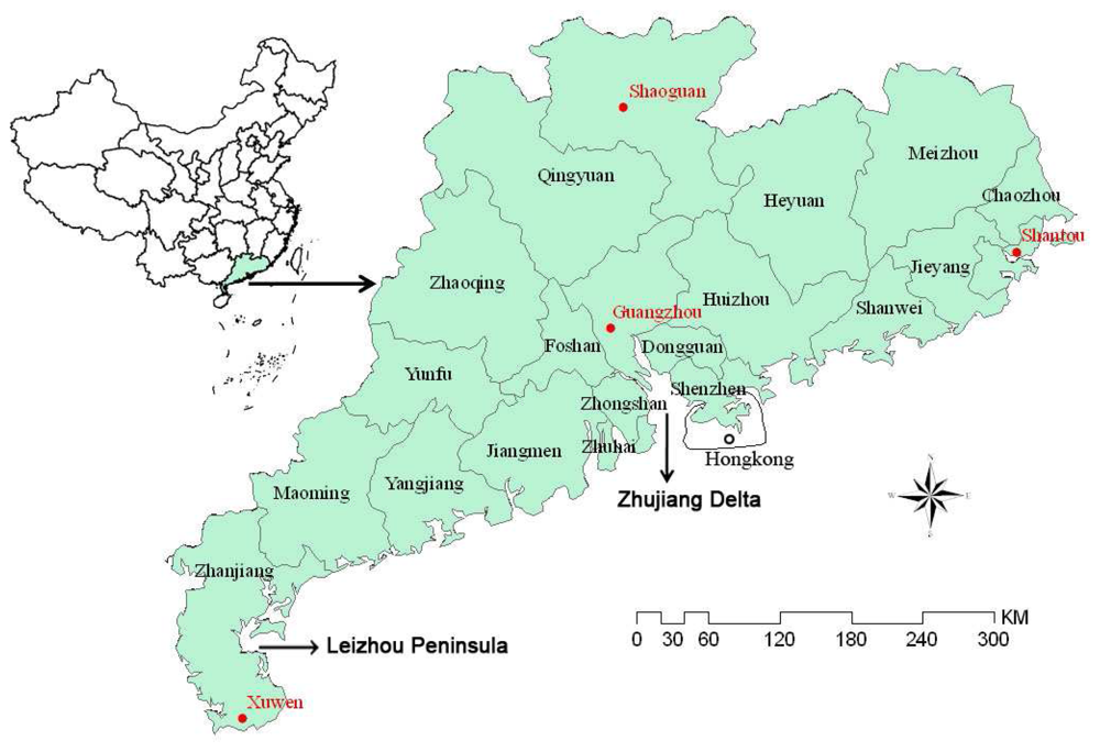
2.1. The study region
2.2 Image data for the study
2.3 Vegetation index for the agro-drought monitoring
2.4 Land surface temperature retrieval for drought monitoring
2.5 Vegetation supply water index (VSWI) as indicator of agro-drought severity
2.6 Improvement of VSWI for agro-drought identification
2.7 Precipitation distance index for drought monitoring
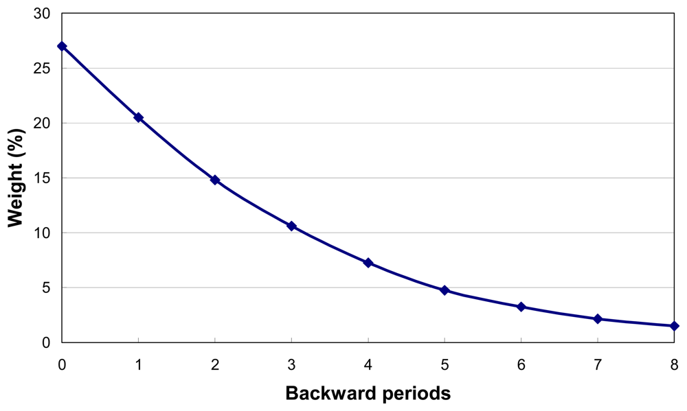
2.8 Development of approach for agro-drought monitoring in Guangdong
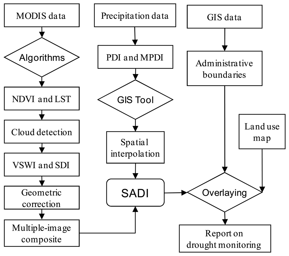
2.9 Image processing procedures in drought monitoring
3. Results and Analysis
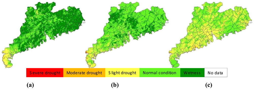
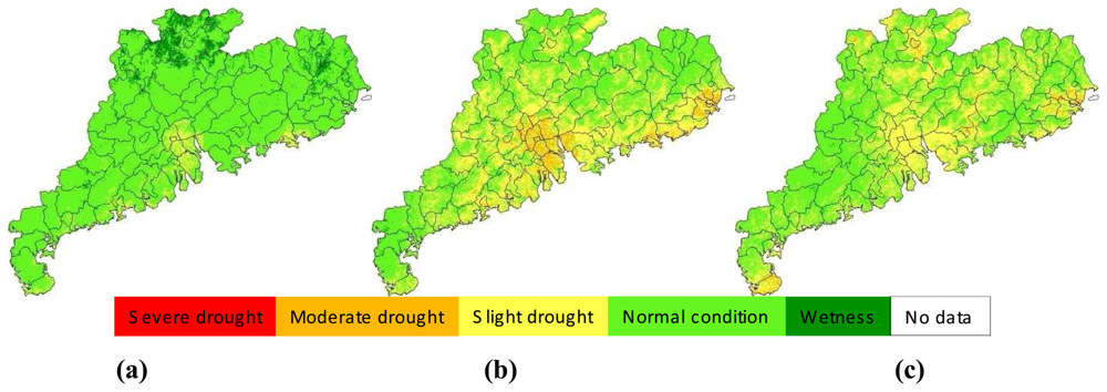
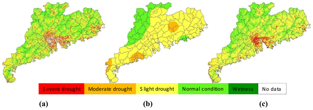
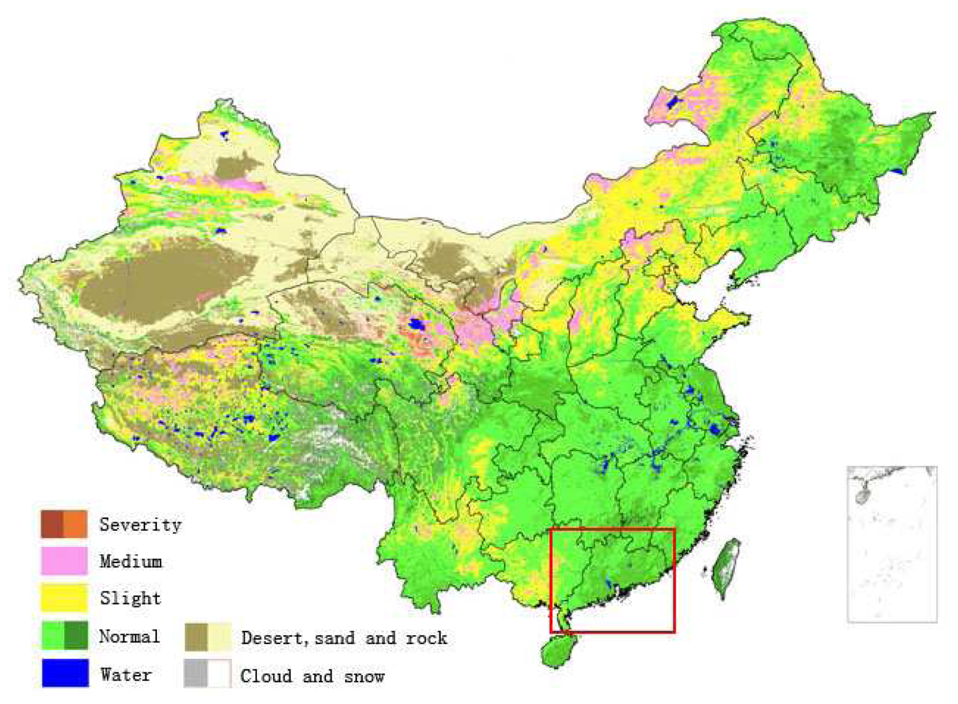
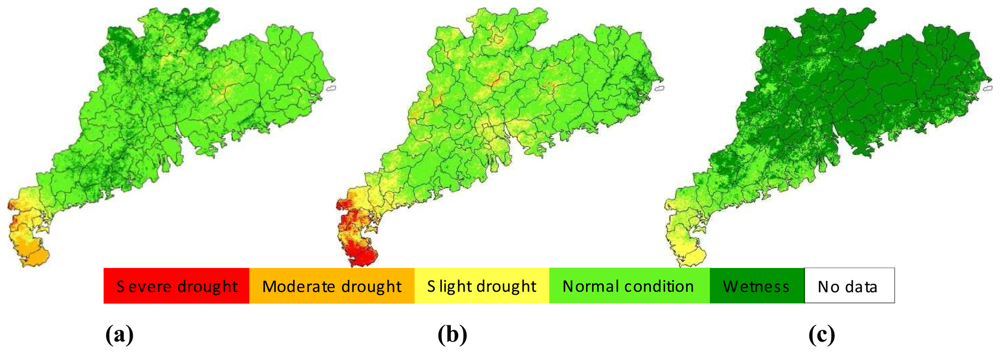
3.1 Spatial distribution of agro-drought in Guangdong
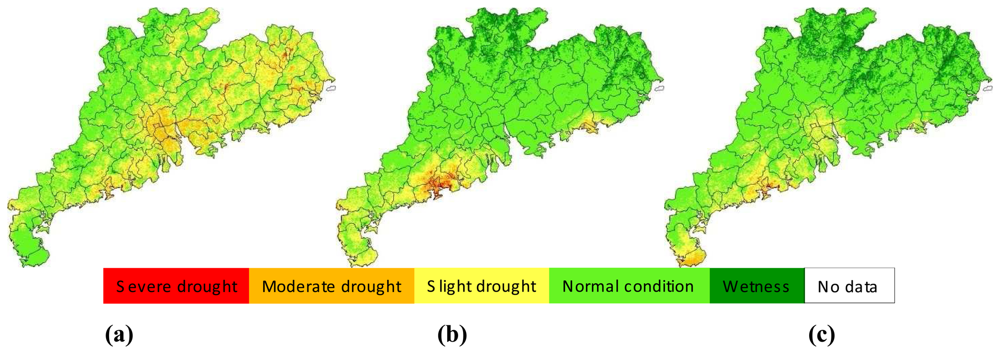
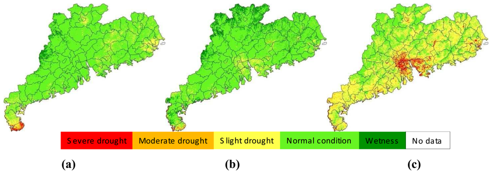
3.2 Seasonal variation of agro-drought in 2006
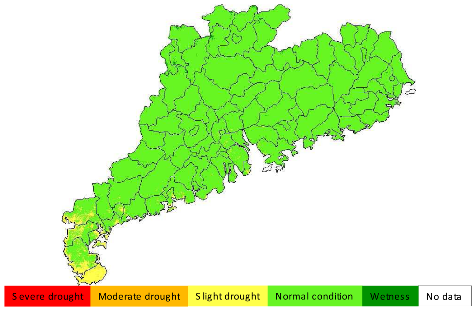
3.3 Comparison of SDI and MPDI for drought monitoring
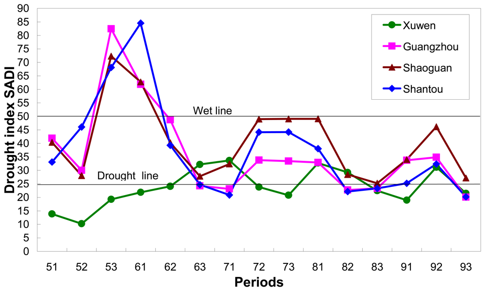
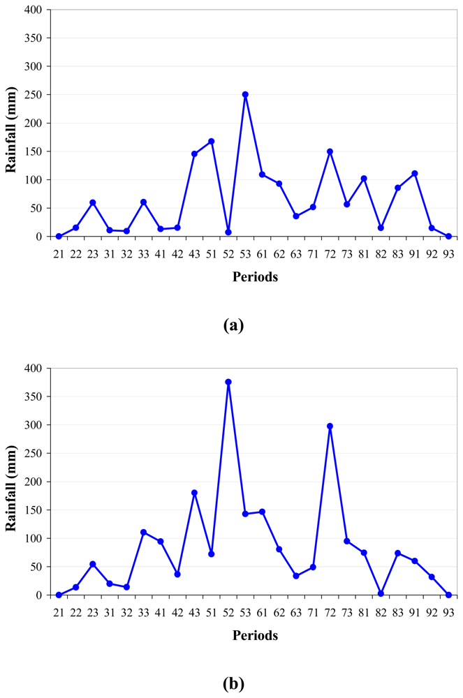
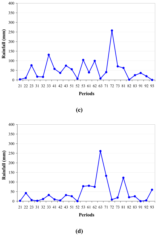
3.4 Comparison with rainfall distribution
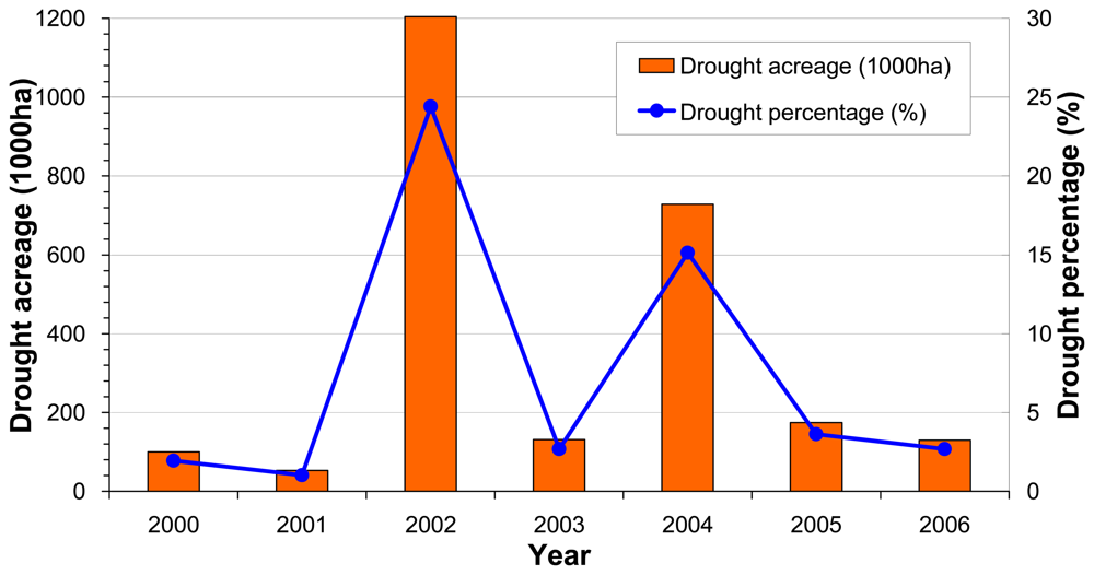
3.4 Comparison with other sources
4. Conclusions
Acknowledgments
References and Notes
- Bowers, S.A.; Hanks, R.J. Reflection of radiant energy from soil. Soil Science 1965, 100(2), 130–138. [Google Scholar]
- Bowers, S.A.; Smith, S.J. Spectrophotometric determination of soil water content. Soil Science Society of America Proceeding 1972, 36, 978–980. [Google Scholar]
- Watson, K.; Rowen, L.C.; Offield, T.W. Application of thermal modeling in the geologic interpretation of IR images. Remote Sensing of Environment 1971, 3, 2017–2041. [Google Scholar]
- Watson, K.; Pohn, H.A. Thermal inertia mapping from satellites discrimination of geologic units in Oman. Journal of Research of U. S. Geological Survey 1974, 2(2), 147–158. [Google Scholar]
- Pratt, D.A.; Ellyett, C.D. The thermal inertia approach to mapping of soil moisture and geology. Remote Sensing of Environment 1979, 8, 151–168. [Google Scholar]
- Price, J.C. On the analysis of thermal infrared imagery, the limited utility of apparent thermal inertia. Remote Sensing of Environment 1985, 18, 59–73. [Google Scholar]
- Idso, S.B.; Schmugge, T.J.; Jackson, R.D. The utility of surface temperature measurements for remote sensing of soil water studies. Journal of Geophysical Research 1975, 80, 3044–3049. [Google Scholar]
- Idso, S.B.; Jackson, R.D.; Pinter, P.J. Normalizing the stress degree of water for environmental variability. Agricultural and Forest Meteorology 1981, 24, 45–55. [Google Scholar]
- Jackson, R.D.; Idso, S.B.; Raginato, R.J. Canopy temperature as a crop water stress indicator. Water Resource Research 1981, 17, 1133–1138. [Google Scholar]
- Kogan, F.N. Remote sensing of weather impacts on vegetation in non-homogeneous areas. International Journal of Remote Sensing 1990, 11, 1405–1419. [Google Scholar]
- Sandholt, I.; Rasmussen, K.; Andersen, J. A simple interpretation of the surface temperature/vegetation index space for assessment of surface moisture status. Remote Sensing of Environment 2002, 79, 213–224. [Google Scholar]
- Carlson, T.N.; Perry, E.M.; Schmugge, T.J. Remote sensing estimation of soil moisture availability and fractional vegetation cover for agricultural fields. Agricultural and Forest Meteorology 1990, 52, 45–69. [Google Scholar]
- Carlson, T.N.; Gillies, R.R.; Perry, E.M. A method to make use of thermal infrared temperature and NDVI measurement to infer surface soil water content and fractional vegetation cover. Remote Sensing Environment 1994, 9, 161–173. [Google Scholar]
- NASA. MODIS Level 1B Product User's Guide, For Level 1B Version 4.3.0 (Terra) and Version 4.3.1 (Aqua); Prepared by Members of the MODIS Characterization Support Team For NASA/Goddard Space Flight Center: Greenbelt, MD 20771, USA, 2003. [Google Scholar]
- Qin, Z.; Dall'Olmo, G.; Karnieli, A.; Berliner, P. Derivation of split window algorithm and its sensitivity analysis for retrieving land surface temperature from NOAA-advanced very high resolution radiometer data. Journal of Geophysical Research 2001, 106(D19), 22655–22670. [Google Scholar]
- Qin, Z.; Gao, M.; Qin, X.; Li, W.; Xu, B. Methodology to retrieve land surface temperature from MODIS data for agricultural drought monitoring in China. Journal of Natural Disasters 2005, 14(4), 64–71. (in Chinese). [Google Scholar]
- Qin, Z.; Gao, M.; Qin, X. An improved approach for agro-drought monitoring in China: Research project report to China Ministry of Agriculture; Institute of Agricultural Resources and Regional Planning, Chinese Academy of Agricultural Sciences: Beijing, China, 2005; p. 41. (in Chinese) [Google Scholar]
- China Ministry of Agricultural (MOA). Chinese Agricultural Statistics 2006; China Agricultural Press: Beijing, China, 2007; p. 326. [Google Scholar]
- http://dear.cma.gov.cn/is_nsmc/info_service/drought/droughtindex.aspx


| NDVI | VSWId | VSWIW | NDVI | VSWId | VSWIw |
|---|---|---|---|---|---|
| <0.05 | 0.11 | 0.25 | 0.35-0.4 | 0.89 | 2.0 |
| 0.05-0.1 | 0.22 | 0.5 | 0.4-0.45 | 1.0 | 2.25 |
| 0.1-0.15 | 0.33 | 0.75 | 0.45-0.5 | 1.11 | 2.5 |
| 0.15-0.2 | 0.44 | 1.0 | 0.5-0.55 | 1.22 | 2.75 |
| 0.2-0.25 | 0.56 | 1.25 | 0.55-0.6 | 1.33 | 3.0 |
| 0.25-0.3 | 0.67 | 1.5 | 0.6-0.65 | 1.44 | 3.25 |
| 0.3-0.35 | 0.78 | 1.75 | 0.65-0.7 | 1.56 | 3.5 |
© 2008 by the authors; licensee Molecular Diversity Preservation International, Basel, Switzerland. This article is an open-access article distributed under the terms and conditions of the Creative Commons Attribution license ( http://creativecommons.org/licenses/by/3.0/).
Share and Cite
Gao, M.; Qin, Z.; Zhang, H.; Lu, L.; Zhou, X.; Yang, X. Remote Sensing of Agro-droughts in Guangdong Province of China Using MODIS Satellite Data. Sensors 2008, 8, 4687-4708. https://doi.org/10.3390/s8084687
Gao M, Qin Z, Zhang H, Lu L, Zhou X, Yang X. Remote Sensing of Agro-droughts in Guangdong Province of China Using MODIS Satellite Data. Sensors. 2008; 8(8):4687-4708. https://doi.org/10.3390/s8084687
Chicago/Turabian StyleGao, Maofang, Zhihao Qin, Hong’ou Zhang, Liping Lu, Xia Zhou, and Xiuchun Yang. 2008. "Remote Sensing of Agro-droughts in Guangdong Province of China Using MODIS Satellite Data" Sensors 8, no. 8: 4687-4708. https://doi.org/10.3390/s8084687