Article

Gravity Survey on the Oil-Bearing Dammam Dome (Eastern Saudi Arabia) and Its Implications

1
Department of Geosciences, College of Petroleum and Geosciences, King Fahd University of Petroleum and Minerals, Dhahran 31261, Saudi Arabia
2
School of Geology, Aristotle University of Thessaloniki, 54124 Thessaloniki, Greece
3
Department of Earth, Environmental and Resources Sciences, University of Naples Federico II, 80138 Naples, Italy
4
Department of Engineering Geology, Hydrogeology and Applied Geophysics, Comenius University Bratislava, 81499 Bratislava, Slovakia
*
Author to whom correspondence should be addressed.
Remote Sens. 2022, 14(3), 735; https://doi.org/10.3390/rs14030735
Submission received: 25 December 2021 / Revised: 24 January 2022 / Accepted: 1 February 2022 / Published: 4 February 2022
(This article belongs to the Special Issue Dynamic Geophysical Phenomenon Monitoring Using Remote Sensing)

Abstract

:
A detailed gravity survey with 235 measurements was carried out at the King Fahd University of Petroleum and Minerals campus, which is located at the crest of the oil-bearing Dammam Dome (Eastern Province of Saudi Arabia). This survey allows us to better understand the geometry of the underlying Dammam Dome and its tectonic regime. The acquired data were processed using conventional gravity data reduction techniques. The effectiveness of terrain correction was evaluated using several recently developed algorithms. Afterward, processed data were subject to geophysical filters for edge detection (terracing transformation and horizontal gradient) and depth estimation (tilt derivative and 3D inversion). 3D Bouguer maps were generated and compared to the proposed geological models for the Dammam Dome. The results show the existence of ENE-WSW striking tectonic lines, where two nearly vertical, km long tectonic lines were predominant. The orientation of these tectonic lines defines an NNW-SSE trend for the least principal stress axis (σ3) and an ENE-WSW trend for the σ1σ2 stress plane of the driving stress regime, fitting well with the transtension stress regime recently suggested for the area. More importantly, the results of this study demonstrate that the Dammam Dome was affected by the intraplate stresses transferred from the convergence between the Arabian and Eurasian plates along the Zagros orogeny.

Graphical Abstract

1. Introduction

For the Oil and Gas Industry, the presence of a dome indicates the entrapment of hydrocarbons since many stratigraphic and structural (anticline, fault) traps are formed [1]. Especially in a salt dome, hydrocarbons get trapped in different parts because of the upward salt motion creating impermeable barriers that stop the flow and migration of oil or gas inside the reservoir [2]. This is why the present study was undertaken on the campus of the King Fahd University of Petroleum and Minerals (KFUPM), located at the crest of the Dammam Dome, not far from the first discovery of oil in Saudi Arabia, back in 1938 [3,4]. Previous studies of this dome suggest that the Jurassic petroleum system of the Arabian Peninsula is one of the world’s most prolific petroleum-producing systems [5]. The Dammam Dome is located in the Eastern Province of Saudi Arabia (Figure 1a), covering an area of about 150 km2 [5]. The cities of Al Dhahran, Al Khobar, and part of the Al Dammam are established on this dome, which lies along the coast of the Arabian Gulf (Figure 1b). However, the exposure of the rocks constituting the Dammam Dome is very limited due to weathering, sand cover, and construction. However, some of the best exposures of the crestal part of the dome are preserved at the headquarters of Saudi Aramco and the KFUPM campus.
Several studies have described the geology of the Dammam Dome (e.g., [3,4,6,7,8,9,10,11,12,13,14,15]), including the recent work by Tranos and Osman [6], who suggested the existence of the Rus soft-sediment detachment at the KFUPM campus, and the influence of the Zagros collision to the Dammam Dome. On the other hand, previous studies have not related the area with the orogenic processes along the Zagros mountain belt [3,4,13,15]. Therefore, the knowledge of the subsurface geology of the Dammam Dome and, more precisely, the deeper subsurface structures might be the key to better understanding the tectonic setting of the Dammam Dome.
Unfortunately, although extensive geophysical studies to characterize the subsurface geology of the Dammam Dome were carried out by the oil industry, they are not publicly available due to confidentiality. As a result, the subsurface geology of the Dammam Dome remains unknown. Ground-penetrating radar (GPR) was used to map near-surface fractures [14], while LANDSAT satellite images were studied to define geological lineaments related to the formation of the Dammam Dome using GIS and remote sensing [15]. Gravimeter-magnetometer surveys started in 1939 and continued after the end of World War II in the wider coastal area of the Arabian Gulf, but their results have not been published [8]. To our knowledge, from that time, no other geophysical survey has been conducted in the study area, apart from some local studies for academic purposes, e.g., a master’s thesis [7].
Although the study of aerial photographs and satellite images [16,17] can reveal the location and shape of a dome when the latter has a morphological expression, like the Dammam Dome, seismic and other geophysical methods are needed to image the dome’s internal structure. Unfortunately, the seismic method does not have a good near-surface resolution, making it harder to study the upper parts of the dome. Thus, a combination of seismic and non-seismic methods, such as gravity, magnetic, electromagnetic (EM), and controlled-source electromagnetic (CSEM) surveys, can provide a more accurate and optimum reconstruction of the dome’s structure [18,19,20]. The gravity method is ideal for mapping subsurface rock layers in salt domes because of the density contrast between the salt and the surrounding rocks. Generally, a salt dome presents an inverted bell-shaped negative anomaly since it shows a relative density-deficiency in contrast with the positive shape-changing anomalies caused by the denser surrounding rocks [21].
The present study pertains to a dense gravity survey at the KFUPM campus. Although the study area covers only a small part of the dome, the detailed survey enables us to better understand the subsurface geology and to provide new inferences about the geological setting of the Dammam Dome.

2. Geological Setting of the Dammam Dome

Topographic maps of the Dammam indicate a large NNW-SSE (~330°) oval hill (~14 km × 9 km) of elevation no more than 150 m, which coincides with the Dammam Dome [12]. The central region of the Dome covers the area of Al Dhahran, where the premises of Saudi Aramco, KFUPM campus, Dhahran Techno Valley, and King Abdulaziz Air Base are located (Figure 1b). A salt layer, which lies at depths of 10–12 km between the Precambrian basement and the overlying Phanerozoic sedimentary sequences of the Arabian Platform (see Figure 7 in [12]), is considered to form the core of the Dammam Dome and the Awali Dome below Bahrain Island [12]. This salt layer is the infra-Cambrian Hormuz Salt, which underlies large parts of the eastern area of the Arabian Plate [12,22,23] and stretches through Iran, Afghanistan, Pakistan, and India [24,25,26,27,28,29,30]. The Dammam Dome has been rising with a rate of up to 7.5 m/My, especially in the Cenozoic Era, and the nearby Awali Dome in Bahrain relates to vertical displacements [12]. Similar dome structures within the Arabian Gulf area, related to hydrocarbon reservoirs, were discovered in Kuwait [31,32] and Qatar [33].
The Dammam Dome consists of sedimentary rocks, which are grouped into the following formations from bottom to top [10] (Figure 1b,c): (a) Rus, (b) Dammam, (c) Hadrukh, and (d) Dam. The Rus and the conformably overlying Dammam Formation are dated as Eocene. The following two formations are dated in the Lower Miocene. They rest unconformably on the Eocene sedimentary rocks due to a major unconformity related to the entire Arabian Platform and are generally referred to as the Pre-Neogene Unconformity (PNU) [8]. The Rus Formation is exposed in the central part of the dome (Figure 1b), where the KFUPM campus is located, and overlies the Paleocene to the Early Eocene Umm er Radhuma (UER) Formation (S.B. Henry and C.W. Brown in 1935 (unpublished Aramco report)). The Rus Formation consists of: (a) The Lower Rus with 21 m of alternations of marls and thin grey to buff dolomitic limestone beds, abundant slumps, and quartz geodes (Zone of Quartz Geods [8]), (b) The Middle Rus, which consists of 10 m of thick grey-buff calcarenite, abundant mud balls, vuggy weathering, and calcite geodes (Zone of Calcite Geods [8]), and (c) The Upper Rus (Chalky Zone of Tleel [8]), which consists of 25 m of yellow-grey, microcrystalline to cryptocrystalline, partly dolomitic, limestone, and white chalky aphanitic limestone, few marl horizons, and clay layers on top. Chert pods or nodules of pebble to boulder size are the most striking feature in the white ’Chalky’ limestone at the top of the Rus Formation [12].
The Dammam Formation (Figure 1c) is distinguished into five members, from the oldest to the youngest: Midra (consisting of brown shale), Saila (two parts, consisting of shale, the upper; and limestone, the lower), Alveolina (composed of dolomitic limestone), Khobar (mainly composed of limestone and marl), and Alat (consisting of limestone and marl—absent in the Dammam Dome area). The Dammam Formation’s outcrops are confined to the rim of the Dome, as well as in Jabal Umm ar Ru’us, north of the KFUPM campus and outside Saudi Aramco’s headquarters (Figure 1b). The Hadrukh and Dam Formations are outside the study area, and their descriptions are left out on purpose, as information on them may be obtained in previously published papers (Figure 1b,c). The Dammam Dome region, as part of the Arabian platform, is in the interior of the Arabian plate and thus too far away from the Zagros orogen (Figure 1a), i.e., the largest mountain belt and the most active collisional orogen demonstrating the Arabia/Eurasia convergence [34,35,36].
Previous studies dealing with the brittle deformation structures in the Dammam Dome (e.g., [3,4,13]) have not provided any connection with large-scale tectonic processes along the Zagros orogen. In particular, the fracture analysis carried out on the KFUPM campus [13] and the broader area of the Dammam Dome [3,4] suggest that the primary joint set in the outcrops of the Dammam Dome area strikes NW-SE, i.e., parallel, instead of orthogonal to the Zagros orogen and is not consistent with the NE-SW to NNE-SSW striking compressional stresses [3,4,13] as the latter detected along the Zagros orogen (Figure 1d) [37]. The exposed faults in the region of the Dammam Dome are very scarce, and even if they are found to be reverse faults, they do not show any consistency with the Zagros orogen [3,4,13].
In contrast, in some Saudi Arabian reservoirs of the Eastern Province of the Arabian Platform, the open natural fractures [38] and published in-situ stress measurements [39] show that intraplate stresses are consistent with the stresses along the Zagros orogen. Moreover, the consistency between the intraplate stresses in the Dammam Dome region and the plate boundary stresses originating from the collisional processes of the Zagros orogen has been demonstrated by the existence of the Rus soft-sediment detachment [6]. The Rus detachment, i.e., the boundary between the Lower and Middle Rus, has been driven by a transtension stress regime with σ1: 159/90°, σ2: 069/00°, σ3: 159/00° stress ratio (R): 0.89 (Figure 1d), and its activity reflects intraplate stresses transferred from the Zagros orogen due to the collision’s inception between the Eurasian and Arabian plates in the Eocene times [6].
Figure 1. Geological setting of the Dammam Dome: (a) The Arabian Peninsula and the Zagros orogen with the location of the Dammam Dome in the Eastern Province of Saudi Arabia [6]. (b) The simplified geological map with the exposed map units of the Dammam Dome (modified from Tranos and Osman [6] as based on Weijermars [12]). (c) Left side: The Cenozoic formations deposited in the Dammam Dome region are shown in the geological time scale. Right side: The stratigraphic columns of the Rus and Dammam Formations. (d) Lower part: The crustal stresses along the Zagros orogen as depicted in the World Stress Map database [40]. Upper part: Equal–area, lower–hemisphere projection showing the planes of the Rus Detachment and the driving transtension stress tensor. σ1, σ2, and σ3 are shown with solid rhomb, circle, and square, respectively, R is the stress ratio [6]. Abbreviations: MZT, Main Zagros Thrust; ZFB, Zagros Fold Belt; KFUPM, King Fahd University of Petroleum and Minerals; E-LR, Eocene—Lower Rus Formation (Middle Rus is also included); E-UR, Eocene—Upper Rus Formation; E-Dm, Eocene—Dammam Formation; Ng-Th, Neogene—Hadrukh Formation; Q, Quaternary undivided.
Remotesensing 14 00735 g001

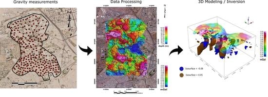
3. Material and Methods

3.1. Gravity Method

In most Saudi Arabian reservoirs of the Eastern Province of the Arabian Platform, the wide-angle seismic reflection is the most commonly used geophysical method in hydrocarbon exploration [41] because it yields the most accurate results concerning the subsurface geology of an area. However, it is costly and time-consuming. Thus, non-seismic geophysical methods such as gravity, magnetic, and electromagnetic are carried out prior to seismic [42].
In this study, the gravity method was implemented since the characteristics of the study area did not allow the application either of the magnetic (urban area, with many buildings and places with concentrations of metals, e.g., roads and construction sites) or the electromagnetic (underground water circulation through sewers and buried pipes, presence of underground cables) methods. Gravity provides information on lateral rock density distribution with depth, using passive, cost-effective techniques compared to the seismic survey. A high-quality gravity survey combined with more sophisticated analytical tools and software can provide a preliminary model of a large region, which provides a basic understanding of its subsurface geology [43].
Due to the ambiguity of gravity anomalies [44], other geological information obtained by surface mapping, cores, and stratigraphic correlations are necessary [43]. Especially in cases where two or more anomalies overlap one another, the interpretation may be confusing due to the superposition of gravity effects from different geological bodies. Furthermore, when the source of an anomaly is located at a larger depth, the resolution of the acquired gravity data deteriorates [43]. In such cases, using supplementary geophysical methods is recommended [45].
Gravity measurements are affected by many parameters, such as coherent and non-coherent noise, elevation, and topography, and their effects have to be removed from the raw data by applying relevant corrections. The raw (collected) data should be corrected for the instrumental drift and earth tide corrections, followed by the Free Air and Bouguer corrections to calculate the simple Bouguer anomaly. By applying correct terrain/topographic correction, the complete Bouguer anomaly (CBA) is estimated. CBA contains both regional and residual (local) anomalies. Depending on the purpose of a study (e.g., hydrocarbon or mineral exploration, structural investigation, civil engineering studies) and the type of survey (land, marine, airborne, satellite), several different corrections may need to be applied [43].

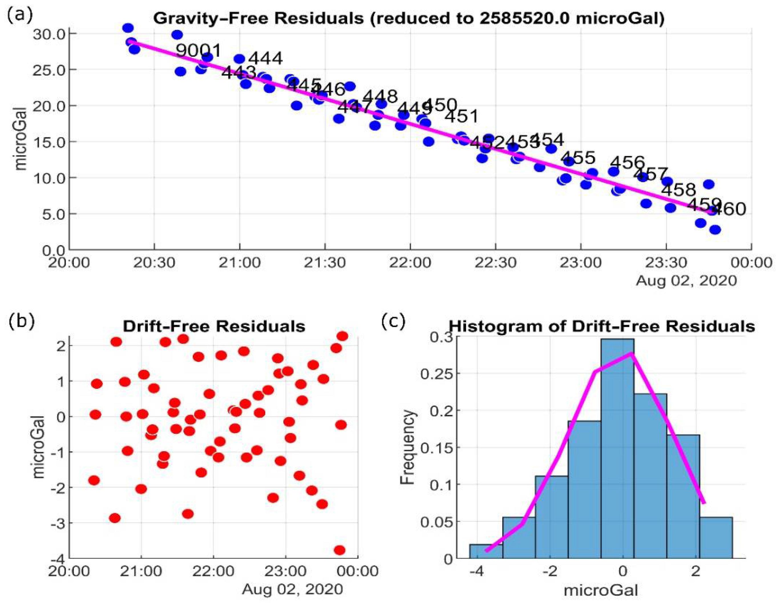
3.2. Gravity Survey—Data Acquisition and Quality Control

In this study, a total of 235 gravity measurements were collected mainly on roads and access paths at the KFUPM campus, where the exposed rocks belong to the Lower and Middle Rus (E-LR in Figure 1b). The measurements cover an area of about 3.5 km2 and are spatially distributed approximately every 100 m (Figure 2). During the measurements, special care was given to minimize errors resulting from noise and high air temperature. For this reason, the data were collected during quiet nights eliminating noise from wind, traffic, and machinery, and temperatures were collected using a CG-5 AUTOGRAV™, manufactured by Scintrex Ltd. This instrument is a microprocessor-based automated gravity meter with a resolution of 1 μGal (10−8 m·s−2). It was set to automatically reject seismic noise and spikes, while it also calculated the Earth tide effect and applied the necessary tilt corrections. Three (3) measuring cycles of 60 sec have been used at every gravity station. For better quality control on the data, if the gravity values of the three cycles differed more than 10 μGal, the measurement was repeated, with the application of more cycles. In cases of higher external noise levels, the cycle duration was increased. Furthermore, stations with tilt greater than 10 arcsec were rejected, and the gravity readings were repeated, resulting in an average standard deviation lower than 20 μGal.
Using SRGM software, the drift was approximated as a polynomial of an appropriate degree. SRGM software runs a program through a MATLAB script [46] that compares the relative gravimetric data collected with the CG-5 gravimeter and is used to correct according to reference networks. For the tidal corrections, TSoft [47] was used. TSoft is a software package developed at the Royal Observatory of Belgium, which can be executed through SRGM and incorporates solid earth tide series and ocean loading in a graphical environment. The quality of data acquired in one of the days of the survey, namely on 2 August 2020, is illustrated in Figure 3. Only minor residuals on the gravity-free (Figure 3a) and the drift-free (Figure 3b) data are observed. The small residuals of the drift-free data are shown in histogram form in Figure 3c.
The height difference from the center of the gravitometer’s mass and the station’s location, typically ranging a few tens of centimeters, was calculated to estimate the instrument’s height correction and reduce every gravity measurement to its exact point. Simultaneously, it was possible to detect and filter out outliers. Since no gravity base stations were available in our study area, the Earth’s normal gravity values for our two local base stations (with codes 9000 and 9001) were chosen as their absolute gravity values. Every day, the measurements started and closed at these two points, while after 2–3 h, we repeated the measurement at one of the base stations to monitor a non-linear drift that needed to be compensated for. Additionally, a sample of stations was repeated on different days to check the consistency of our measurements.
Building effect refers to the gravitational effect caused by buildings and relevant constructions (bridges, stadiums, malls, etc.) close to the gravity stations [48], as it happens on the KFUPM campus with the existence of a large number of buildings. A method to compute and correct the Building effect on raw gravity data is to put the building heights into the calculations by applying the “Building Correction”, achieved using LIDAR or any other similar dataset [48]. Unfortunately, such datasets were not available for the present survey. For the building effect to be as small as possible, previous gravity surveys, e.g., a gravity survey of the Athens basin (Greece) by Dilalos et al. [48], have used a distance of at least 75 m between stations and buildings. However, such distances could not be achieved inside the KFUPM campus, where the spacing between the buildings is very small, without omitting large areas. Because of this, it was decided that the least distance between the stations and buildings should not be less than 30 m. Finally, the location and elevation of each gravity station were measured using a Trimble Differential GPS (DGPS) R10+, with an error of less than 1 cm in both horizontal and vertical directions.
Afterward, the gravity data were imported to Geosoft Inc. Oasis Montaj (version 9.10) software. Oasis Montaj (https://www.seequent.com/ accessed on 2 January 2022) is a cutting-edge software that includes a suite of modeling and analyzing tools, useful for a detailed understanding of the Earth’s subsurface. The tide correction, the instrumental drift, and the instrument’s height correction were recalculated and compared with the SRGM results. The calculations of the two programs were similar, while their only minor differences were attributed to the tidal correction model that each software utilizes. The Earth’s normal gravity at the base stations 9000 and 9001 was calculated using the 1980 International Gravity Formula [49]. Consequently, the theoretical gravity correction at these stations was equal to zero. Finally, the simple Bouguer anomaly and free-air anomaly were calculated using standard procedures. When an absolute gravity point in the vicinity of the study area is available, the base stations will be connected to the International Absolute Gravity Base Station Network, and consequently, every other station as part of this survey.
Topography is one of the main contributors to gravity anomalies due to its proximity to the measurement points and the high-density contrast between rock formations and the surrounding atmosphere. The variability of the surrounding topography must be provided in detail because of its strong effect on measurements due to the inverse square law of gravity. The surface relief on a land gravity station always decreases the mass correction, whether it is positive (above the station) or negative (below the station). For a structure located at a distance from the area of measurements, the effect on gravity is small. Thus, a larger grid spacing can be utilized. Since there was no detailed elevation model for our study area, the SRTM (Shuttle Radar Topography Mapping) Digital Elevation Database v.4.1 at 90 m from CGIAR Consortium for Spatial Information (CGIAR-CSI) was utilized for the construction of the local Digital Elevation Model (DEM). Although there are other more detailed DEMs available online, the CGIAR-CSI was preferred because it had the best resemblance to our DGPS elevation data that we measured during the survey. As the regional DEM, the open-source SRTM15+ dataset was used, including the global bathymetry and the topography at 15 arc seconds [50], with a grid spacing of about 415 m. The final local DEM, shown in Figure 4, was constructed by merging CGIAR topography and SRTM15+ bathymetry data. The resolution below sea level is similar to SRTM15+.
Topographic correction (or terrain effect) was applied to reduce the influence of local topography on the observed values of gravity at the measuring stations [43]. For estimating the topographic correction, four routines were tested, namely the GTeC (Gravity Terrain Correction) [51], Toposk [52], TriTop [53], and Geosoft Gravity and Terrain Correction extension (https://www.seequent.com/ accessed on 2 January 2022), and the results of each one were evaluated. GTeC is an executable public domain code that uses the MATLAB environment for terrain correction in which absolute gravity measurements or free-air anomalies on land or sea surface are inserted, together with one or more Digital Terrain Models (DTMs) at different detail levels [51]. The software creates concentric terrain zones around each gravity station, with increasing resolution toward the center, each with a different contribution to the gravity measurement. The processing with GTeC software provides precise terrain correction results, especially in areas with high topographic gradients or just outside the land/sea boundaries [51].
Toposk software was initially designed for the Slovakia region in Europe but is now modified for wider areas and various coordinate systems. It uses the C++ programming language to calculate the topographic mass gravitational effect on the measurements and eliminate this effect [52]. This correction is achieved by subtracting a truncated spherical layer (or a vertical cylinder in the planar approach) from the gravitational effect [52]. However, the currently available software version cannot calculate bathymetric effects and apply the relevant correction since it is mainly utilized for continental study area cases (such as Slovakia, where it was first tested).
TriTop software uses an adaptive algorithm that calculates the topographic correction of gravity measurements based on a triangulated polyhedral representation of topographic surfaces [53]. The topography is split into blocks of increasing resolution, and they are arranged into a quadtree structure until the higher resolution would lead to changes in gravity below a limit value defined by the researcher. TriTop software is generally helpful in cases of very rugged topography, where the gravity effect is high.
Geosoft’s Gravity and Terrain Correction extension is executed through the Oasis Montaj environment and provides a complete system for processing and reducing gravity data from conventional ground surveys. It applies terrain corrections from DEMs or gridded elevation data by calculating the regional terrain correction from a coarse regional DEM over a more finely sampled local DEM covering the study area. By this method, a “regional correction grid” is constructed that represents terrain corrections beyond a local distance. The latter is used to calculate corrections at each gravity station in detail.
Those algorithms have been recently developed, and the reason why we applied them in the current study was to test them on our data and cross-check their results. We noticed the similarities on the produced topographic correction maps, as shown in Figure 5 for three of the above routines (Gravity and Terrain Correction (Figure 5a), Toposk (Figure 5b), TriTop (Figure 5c)). These three algorithms are compared in Table 1 by statistical analysis. Since the results from the three tested algorithms were quite similar, Geosoft’s Terrain Correction algorithm was ultimately chosen to estimate the topographic corrections in our study and to calculate the Complete Bouguer anomaly so as to be consistent with the rest of the processing.

4. Results

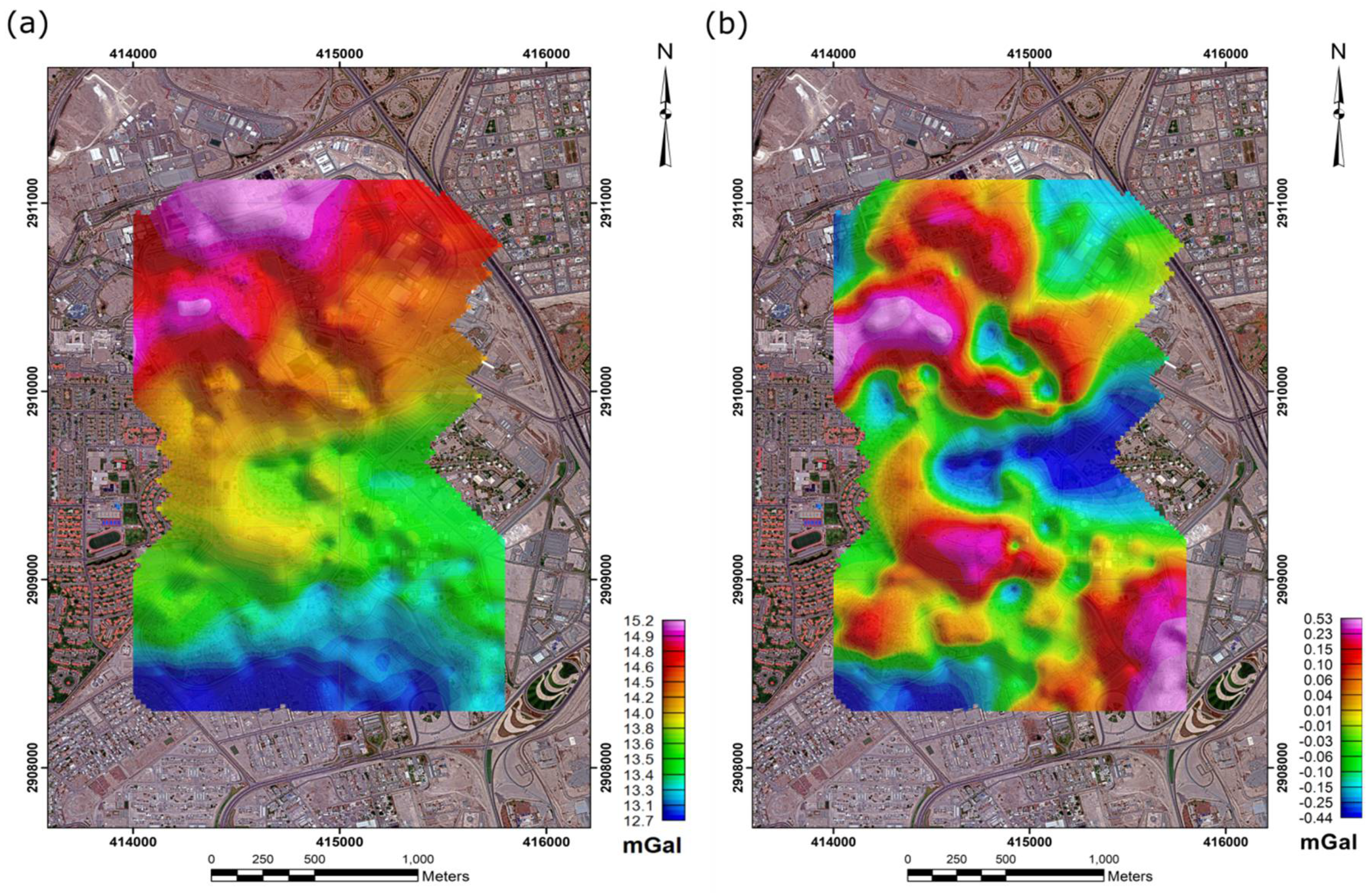
4.1. Model and Data Processing Results

In Figure 6a, the Complete Bouguer anomaly map using Geosoft’s Terrain Correction algorithm is presented. Note that the gravity field is the sum of the long- and short-wavelength anomalies at a given point. However, the near-surface noise is extracted from the measured gravity field to define the deep geological structures related to the regional gravity field [43].
We separated the regional and residual gravity field from the complete Bouguer anomaly map (Figure 6a) after applying Geosoft’s Gravity and Terrain Correction. More precisely, the polynomial surface-fitting method by applying Fourier Transformation [54] was chosen to define the residual gravity field (Figure 6b). The estimated GEOSOFT polynomial surface has a gentle slope to the SE, which fits well with the geometric properties of the Dammam Dome since the study area is on the SE crestal part of the latter (Figure 1b).
To delineate the boundaries of the anomalies’ sources and to detect other tectonic elements and features, such as possible fault lines or fractures from the Bouguer anomaly and residual maps, the residual gridded data were processed with the horizontal gradient magnitude (HGM) technique [55]. This technique is helpful in cases where variations in gravity values indicate variations in densities that are related to the geologic structures. The HGM grid was constructed, and then its maxima were estimated using the curvature analysis algorithm of Phillips et al. [56]. The results of this analysis exhibited peaks over the edges of horizontal formations and their vertical contacts due to differences in density. Another implemented filter we used was the terracing transformation operator proposed by Cordell and McCafferty [57]. The filter is applied to potential field data to produce regions (terraces) of constant field amplitude, separated by sharp boundaries.
The tilt derivative enhancement filter [58,59] was applied to highlight local anomalies, including those of low amplitude. If applied to potential field grid data, it can act as a type of automatic gain control (AGC). The tilt derivative was estimated using Geosoft’s Oasis Montaj software. The filter incorporates the tilt depth estimate technique of Salem et al. [60] and provides both a qualitative and a quantitative approach to anomalies’ interpretation, as it informs on the burial depth of the structures of interest by showing the upper part of the anomalies’ sources [60]. Moreover, this method is less sensitive to noise than methods relying on higher-order derivatives (https://www.seequent.com/ accessed on 2 January 2022).
Figure 7a shows the terracing map (as a colored grid) together with the horizontal gradient magnitude (HGM) maxima, as black line segments indicating the strike of each contact [56]. The depth solutions calculated using the tilt derivative filter are also presented in Figure 7a as colored range symbols. As shown in Figure 6b and Figure 7a, positive anomalies against negative ones, indicate higher and lower density sources, respectively. These sources coincide mainly with two lines labeled A and B (Figure 7a), which trend ENE-WSW. Line A is the longest one with more than 1.6 km in length and trends N070°. Line B lies about 0.5 km to the south and with a length of about 1.3 km trends N066°. The ENE-WSW (061°) trend is also defined by the maxima of the strongest 25% of the horizontal gradient magnitude (HGM) strikes (Figure 7b).

4.2. 3D Modeling

Three-dimensional (3D) unconstrained gravity inversion was carried out on the residual field data using the VOXI Earth Modeling extension of Oasis Montaj software (https://www.seequent.com/ accessed on 2 January 2022). VOXI applies cloud-based forward modeling and inversion in potential field (gravitational and magnetic) data [61], and its algorithm predicts a three-dimensional distribution of the physical property, i.e., the density distribution. For making the necessary calculations, our study area was discretized in a three-dimensional mesh with blocks of 75 × 75 × 25 m dimension.
The inversion results show that lines A and B correspond to two tubular, almost vertical bodies of positive (greater than 0.05 gr/cm³) and negative (lower than −0.08 gr/cm³) density contrasts, respectively, as shown in the 3D models (Figure 8). The thicknesses of the two bodies increased with depth and presented a mean value of about 50 m. These bodies crosscut the substratum of the KFUPM campus at depths more than 100 m with an ENE-WSW trend, causing a strong gravity imprint.

5. Interpretation-Discussion

The gravity survey defined two almost vertical bodies, A and B (corresponding to lines A and B, respectively, on Figure 7a and Figure 8), trending ENE-WSW that crosscut the Lower and Middle Rus Formations. It also showed that the general gravity imprint is of a similar ENE-WSW trend as the latter is determined by the horizontal gradient magnitude (HGM) maxima (Figure 7b). Such trends have been defined by the exposed joints on the KFUPM campus, but they do not belong to the main exposed joint set since the latter strikes NNW-SSE [13] (Figure 7a).
The tubular shape and the thickness of the bodies A and B, which is of some decades of meters and increase with depth, do not facilitate the interpretation of these structures as joints, i.e., the main deformation structures seen on the rock exposures in the Dammam Dome area, even though these bodies are almost vertical. Instead, they can be interpreted as either clastic or diapiric dikes. They can also be interpreted as fault structures. However, the last interpretation is not facilitated by the vertical attitude of the two bodies unless they are strike-slip faults since these vertical faults cannot be considered as pre-existing (or inherited) structures.
Therefore, interpreting these bodies as diapiric or clastic dikes can classify them as Mode I structures trending ENE-WSW. Their orientations define the least principal stress axis (σ3) of the driving stress regime, which is normal to their planes, to trend NNW-SSE. Furthermore, their planes coincide with the σ1σ2-principal stress plane of the driving stress regime and define that the horizontal greatest stress axis (σH) trends ENE-WSW, i.e., similar to in situ stresses defined by the open natural fractures found in the reservoirs of the Eastern Province [38,39]. These in situ stresses are related with an intraplate stress regime that is of strike-slip (σH > σV > σh) or of transitional extensional to strike-slip nature (σH > σV > σh), i.e., locally transtensional [38,39]. In addition, the inferred stresses fit well with the transtension stress regime as the latter was defined by the activity of the soft-sediment Rus detachment that is also exposed on the KFUPM campus [6]. This transtension stress regime reflects intraplate stresses transferred from the stresses that originated along the Arabian-Eurasian plates due to their collision along the Zagros orogen [6].
Even if these bodies, A and B, are considered as faults (either strike-slip or normal), their horizontal greatest principal stress axis (σH) cannot be of NNW-SSE trending, i.e., similar to that defined by Al-Fahmi [3], Al-Fahmi et al. [4], and Hariri [13]. Instead, their stress axis σH trends ENE-WSW, deviating no more than 45° from this direction [62], i.e., similar to in situ stresses defined by the open natural fractures found in the reservoirs of the Eastern Province [38,39] and the stresses defined by Tranos and Osman [6]. Therefore, the geometric properties of the bodies A and B do not facilitate the results of the fracture analysis carried out on the KFUPM campus [13] and the broader area of the Dammam Dome [3,4], indicating that the horizontal greatest principal stress axis (σH) of the driving stress regime is not normal to the plate boundary between the Arabian and Eurasian plates. Consequently, the Dammam Dome was not considered to relate with intraplate stresses transferred from the plate boundary stresses along the Zagros orogen [3,4,13].

6. Conclusions

A 3D model of the subsurface geology of the oil-bearing Dammam Dome in the Eastern Province of Saudi Arabia was accomplished based on the detailed gravity survey we conducted at the KFUPM campus at the crest of the Dome. This survey applied the horizontal gradient magnitude (HGM) filter to distinguish subdomains with different density contrasts that show possible karstifications. Our results show that in the Dammam Dome, there are areas with positive and negative density contrasts. The spatial distribution of the contrasting density area defines two large ENE-WSW striking tectonic lines, which correspond to sub-vertical bodies of an average thickness of 50 m, although this thickness increases in depth. We interpret these bodies as diapiric or clastic dikes and, thus, as Mode I structures. Their trend defines the least principal stress axis (σ3) or the minimum horizontal stresses (σh) of the driving stress regime, which is normal to their planes, to trend NNW-SSE. Furthermore, their planes coincide with the σ1σ2-principal stress plane of the driving stress regime and define that the horizontal greatest stress axis (σH) trends ENE-WSW, i.e., similar to in situ stresses defined by the open natural fractures found in the reservoirs of the Eastern Province [38,39] and the stresses defined by Tranos and Osman [6].
However, they do not fit well with the stresses defined from the exposed joints on the outcrops of the Dammam Dome [3,4,13]. As a result, our gravity data support the conclusion that the Dammam Dome was affected by the intraplate stresses transferred from the convergence between the Arabian and Eurasian plates along the Zagros Orogeny in Tertiary times.
Additional geophysical surveys, including expanded gravity measurements covering the broader Dammam Dome area, measurements of ambient seismic noise arrays and horizontal-to-vertical spectral ratio (HVSR) stations, refraction seismic measurements, geoelectrical measurements, and electromagnetic radar pulses using ground penetrating radar (GPR), are recommended and planned to obtain a better image of the Dammam Dome.

Author Contributions

Conceptualization, P.S. and A.S.; methodology, P.S. and A.S.; software, K.C., A.S., P.S. and M.T.; validation, A.S., M.T. and P.S.; formal analysis, A.S., M.T. and P.S.; investigation, P.S.; resources, P.S.; data curation, K.C., A.S., M.T. and P.S.; writing—original draft preparation, K.C., A.S., P.K., M.T. and P.S.; writing—review and editing, K.C., A.S., P.K., M.T., M.F., R.P., K.A.-R., S.K., G.N.T. and P.S.; visualization, K.C., A.S., P.K., M.T. and P.S.; supervision, P.S.; project administration, P.S.; funding acquisition, P.S. All authors have read and agreed to the published version of the manuscript.

Funding

This research was funded in part by the start-up grant (SF18063) from the College of Petroleum Engineering and Geosciences (CPG) at King Fahd University of Petroleum and Minerals (KFUPM).

Institutional Review Board Statement

Not applicable.

Informed Consent Statement

Not applicable.

Data Availability Statement

Not applicable.

Acknowledgments

The authors gratefully acknowledge CPG for technical and financial support and to George Soupios for acquiring the raw data.

Conflicts of Interest

The authors declare no conflict of interest. The funders had no role in the design of the study; in the collection, analyses, or interpretation of data; in the writing of the manuscript, or in the decision to publish the results.

References

  1. Onajide, E. Seismic Data Analysis Techniques in Hydrocarbon Exploration; Elsevier: Boston, MA, USA, 2014; ISBN 9780124200234. [Google Scholar]
  2. Magoon, L.B.; Dow, W.G. The Petroleum System—From Source to Trap; American Association of Petroleum Geologists: Tulsa, OK, USA, 1994; ISBN 9781629810928. [Google Scholar]
  3. Al-Fahmi, M.M. Fractures of the Dammam Dome Carbonate Outcrops: Their Characterization, Evolution and Implications to Deep Reservoirs. Master’s Thesis, University of Massachusetts Amherst, Amherst, MA, USA, 2012. [Google Scholar]
  4. Al-Fahmi, M.M.; Cooke, M.L.; Cole, J.C. Modeling of the Dammam outcrop fractures: Case study for fracture development in salt-cored structures. GeoArabia 2014, 19, 49–80. [Google Scholar] [CrossRef]
  5. Pollastro, R.M. Total Petroleum Systems of the Paleozoic and Jurassic, Greater Ghawar Uplift and Adjoining Provinces of Central Saudi Arabia and Northern Arabian-Persian Gulf; U.S. Geological Survey Bulletin; U.S. Geological Survey: Reston, VA, USA, 2003; Volume 52. [CrossRef]
  6. Tranos, M.D.; Osman, M.S. Rus detachment in Dammam Dome, Eastern Saudi Arabia: A new soft-sediment structure as a “sensitive stress tensor” for the Zagros collision. Geol. Mag. 2021, 1–13. [Google Scholar] [CrossRef]
  7. Hanif, M. Near-surface investigations of the Dammam Dome on the KFUPM campus using the gravity method. Master’s Thesis, King Fahd University of Petroleum & Minerals, Dhahran, Saudi Arabia, 2018. [Google Scholar]
  8. Tleel, J.W. Surface geology of Dammam Dome, Eastern province, Saudi Arabia. Am. Assoc. Pet. Geol. Bull. 1973, 57, 558–576. [Google Scholar] [CrossRef]
  9. Steineke, M.; Harriss, T.; Parsons, K.; Berg, E. Geographic Map of the Western Persian Gulf Quadrangle, Kingdom of Saudi Arabia; U.S. Geological Survey: Reston, VA USA, 1958.
  10. Powers, R.; Ramirez, L.; Redmond, C.; Elberg, E. Geology of the Arabian Peninsula—Sedimentary geology of Saudi Arabia. Geol. Surv. Prof. Pap. 1966, 560, 147. [Google Scholar]
  11. Çaġatay, M.N. Palygorskite in the eocene rocks of the Dammam Dome, Saudi Arabia. Clays Clay Miner. 1990, 38, 299–307. [Google Scholar] [CrossRef]
  12. Weijermars, R. Surface geology, lithostratigraphy and tertiary growth of the Dammam Dome, Saudi Arabia: A new field guide. GeoArabia 1999, 4, 199–226. [Google Scholar] [CrossRef]
  13. Hariri, M.M. Fractures system within Dammam Dome and its relationship to the doming process, Eastern Saudi Arabia. Arab. J. Geosci. 2014, 7, 4943–4956. [Google Scholar] [CrossRef]
  14. Al-Shuhail, A.A.; Hariri, M.M.; Makkawi, M.H. Using ground-penetrating radar to delineate fractures in the Rus Formation, Dammam Dome, Eastern Saudi Arabia. Int. Geol. Rev. 2004, 46, 91–96. [Google Scholar] [CrossRef]
  15. Hariri, M.M.; Abdullatif, O. Use of the GIS to delineate lineaments from landsat images, Dammam Dome, Eastern Saudi Arabia. In Proceedings of the XXII International Cartographic Conference (ICC2005), A Coruna, Spain, 11–16 July 2005; p. 7. [Google Scholar]
  16. Berger, Z. Satellite Hydrocarbon Exploration; Springer: Berlin/Heidelberg, Germany, 1994; ISBN 9783642785870. [Google Scholar]
  17. Frassy, F.; Maianti, P.; Marchesi, A.; Nodari, F.R.; Dalla Via, G.; De Paulis, R.; Biffi, P.G.; Gianinetto, M. Satellite remote sensing for hydrocarbon exploration in new venture areas. Int. Geosci. Remote Sens. Symp. 2015, 2015, 2884–2887. [Google Scholar] [CrossRef]
  18. Strack, K.M. Future directions of electromagnetic methodsfor hydrocarbon applications. Surv. Geophys. 2014, 35, 157–177. [Google Scholar] [CrossRef]
  19. Lyatsky, H. Gravity and magnetic geophysical methods in oil exploration. EP Mag. 2016, 52–54. [Google Scholar]
  20. Constable, S. Perspectives on Marine Electromagnetic Methods. Perspect. Earth Space Sci. 2020, 1, e2019CN000123. [Google Scholar] [CrossRef]
  21. Alsadi, H.N. Seismic Hydrocarbon Exploration: 2D and 3D Techniques; Springer: Berlin/Heidelberg, Germany, 2017; ISBN 9783319404356. [Google Scholar]
  22. Edgell, H.S. Basement tectonics of Saudi Arabia as related to oil field structures. In Basement Tectonics 9; Rickard, M.J., Ed.; Kluwer Academic Publishers: Dordrecht, The Netherlands, 1992; pp. 169–193. [Google Scholar]
  23. Stewart, S.A. Hormuz salt distribution and influence on structural style in NE Saudi Arabia. Pet. Geosci. 2017, 24, 143–158. [Google Scholar] [CrossRef]
  24. Stöcklin, J. Structural history and tectonics of Iran: A review. Am. Assoc. Pet. Geol. Bull. 1968, 52, 1229–1258. [Google Scholar] [CrossRef]
  25. Talbot, C.J. Extrusions of Hormuz salt in Iran. Geol. Soc. Spec. Publ. 1998, 143, 315–334. [Google Scholar] [CrossRef]
  26. Al-Husseini, M.I. Origin of the Arabian plate structures: Amar Collision and Najd Rift. GeoArabia 2000, 5, 527–542. [Google Scholar] [CrossRef]
  27. Konert, G.; Afifi, A.M.; Al-Hajri, S.A.; Droste, H.J. Paleozoic stratigraphy and hydrocarbon habitat of the Arabian plate. GeoArabia 2001, 6, 407–442. [Google Scholar] [CrossRef]
  28. Aftabi, P.; Roustaie, M.; Ian Alsop, G.; Talbot, C.J. InSAR mapping and modelling of an active iranian salt extrusion. J. Geol. Soc. 2010, 167, 155–170. [Google Scholar] [CrossRef]
  29. Khodabakhshnezhad, A.; Arian, M. Salt tectonics in the Southern Iran. Int. J. Geosci. 2016, 07, 367–377. [Google Scholar] [CrossRef] [Green Version]
  30. Hassanpour, J.; Yassaghi, A.; Muñoz, J.A.; Jahani, S. Salt tectonics in a double salt-source layer setting (Eastern Persian Gulf, Iran): Insights from interpretation of seismic profiles and sequential cross-section restoration. Basin Res. 2020, 33, 159–185. [Google Scholar] [CrossRef]
  31. Milton, D.I. Geology of the Arabian Peninsula, Kuwait; USGS Numbered Series; United States Government Printing Office: Washington, DC, USA, 1967; Volume 14. [CrossRef]
  32. Tanoli, S.K.; Al-Bloushi, A.J. Depositional history of the eocene Dammam formation in Kuwait. In Proceedings of the Society of Petroleum Engineers—SPE Kuwait Oil and Gas Show and Conference 2017, Kuwait City, Kuwait, 15–18 October 2017; pp. 1–14. [Google Scholar] [CrossRef]
  33. Al-Saad, H.; Ibrahim, M.I. Stratigraphy, micropaleontology, and paleoecology of the Miocene Dam Formation, Qatar. GeoArabia 2002, 7, 9–28. [Google Scholar] [CrossRef]
  34. Dewey, J.F.; Pitman, W.C.; Ryan, W.B.F.; Bonnin, J. Plate tectonics and the evolution of the alpine system. Bull. Geol. Soc. Am. 1973, 84, 3137–3180. [Google Scholar] [CrossRef]
  35. Dercourt, J.; Zonenshain, L.P.; Ricou, L.E.; Kazmin, V.G.; Le Pichon, X.; Knipper, A.L.; Grandjacquet, C.; Sbortshikov, I.M.; Geyssant, J.; Lepvrier, C.; et al. Geological evolution of the tethys belt from the atlantic to the pamirs since the LIAS. Tectonophysics 1986, 123, 241–315. [Google Scholar] [CrossRef]
  36. Stampfli, G.M.; Borel, G.D. A plate tectonic model for the paleozoic and mesozoic constrained by dynamic plate boundaries and restored synthetic oceanic isochrons. Earth Planet. Sci. Lett. 2002, 196, 17–33. [Google Scholar] [CrossRef]
  37. Lacombe, O.; Mouthereau, F.; Kargar, S.; Meyer, B. Late cenozoic and modern stress fields in the western Fars (Iran): Implications for the tectonic and kinematic evolution of central Zagros. Tectonics 2006, 25. [Google Scholar] [CrossRef] [Green Version]
  38. Ameen, M.S.; Hailwood, E.A. A new technology for the characterization of microfractured reservoirs (test case: Unayzah reservoir, Wudayhi field, Saudi Arabia). Am. Assoc. Pet. Geol. Bull. 2008, 92, 31–52. [Google Scholar] [CrossRef]
  39. Ameen, M.S. Fracture and in-situ stress patterns and impact on performance in the Khuff structural prospects, eastern offshore Saudi Arabia. Mar. Pet. Geol. 2014, 50, 166–184. [Google Scholar] [CrossRef]
  40. Heidbach, O.; Rajabi, M.; Cui, X.; Fuchs, K.; Müller, B.; Reinecker, J.; Reiter, K.; Tingay, M.; Wenzel, F.; Xie, F.; et al. The World Stress Map database release 2016: Crustal stress pattern across scales. Tectonophysics 2018, 744, 484–498. [Google Scholar] [CrossRef]
  41. Alfaraj, M.N.; Nebrija, E.L.; Ferguson, M.D. The challenge of interpreting 3-D seismic in Shaybah Field, Saudi Arabia. GeoArabia 1998, 3, 209–226. [Google Scholar] [CrossRef]
  42. Hinze, W.J.; Von Frese, R.R.B.; Saad, A.H. Gravity and Magnetic Exploration: Principles, Practices, and Applications; Cambridge University Press: Cambridge, UK, 2010; ISBN 9780511843129. [Google Scholar]
  43. Fairhead, J.D. Advances in Gravity and Magnetic Processing and Interpretation; EAGE Publications: Houten, The Netherlands, 2016; ISBN 9462821771. [Google Scholar]
  44. Blakely, R. Potential Theory in Gravity & Magnetic Applications; Cambridge University Press: Cambridge, UK, 1995. [Google Scholar] [CrossRef]
  45. Coates, R. The Defining Series: Geophysics. Oilfield Review. 2016. Available online: https://www.slb.com/-/media/files/oilfield-review/defining-geophysics.ashx (accessed on 10 December 2021).
  46. Hábel, B.; Janák, J.; Papčo, J.; Val’ko, M. Impact of environmental phenomena on continuous relative gravity measurements performed in urban area. Stud. Geophys. Geod. 2020, 64, 330–348. [Google Scholar] [CrossRef]
  47. Van Camp, M.; Vauterin, P. Tsoft: Graphical and interactive software for the analysis of time series and Earth tides. Comput. Geosci. 2005, 31, 631–640. [Google Scholar] [CrossRef]
  48. Dilalos, S.; Alexopoulos, J.D.; Tsatsaris, A. Calculation of building correction for urban gravity surveys. A case study of Athens metropolis (Greece). J. Appl. Geophys. 2018, 159, 540–552. [Google Scholar] [CrossRef]
  49. Moritz, H. Geodetic reference system 1980. Bull. Géodésique 1980, 54, 395–405. [Google Scholar] [CrossRef]
  50. Tozer, B.; Sandwell, D.T.; Smith, W.H.F.; Olson, C.; Beale, J.R.; Wessel, P. Global bathymetry and topography at 15 arc sec: SRTM15+. Earth Space Sci. 2019, 6, 1847–1864. [Google Scholar] [CrossRef]
  51. Cella, F. GTeC-A versatile MATLAB® tool for a detailed computation of the terrain correction and Bouguer gravity anomalies. Comput. Geosci. 2015, 84, 72–85. [Google Scholar] [CrossRef]
  52. Zahorec, P.; Marušiak, I.; Mikuška, J.; Pašteka, R.; Papčo, J. Numerical calculation of terrain correction within the Bouguer anomaly evaluation (program Toposk). In Understanding the Bouguer Anomaly: A Gravimetry Puzzle; Pašteka, R., Mikuška, J., Meurers, B., Eds.; Elsevier: Amsterdam, The Netherlands, 2017; pp. 79–92. ISBN 9780128129142. [Google Scholar]
  53. Holzrichter, N.; Szwillus, W.; Götze, H.J. An adaptive topography correction method of gravity field and gradient measurements by polyhedral bodies. Geophys. J. Int. 2019, 218, 1057–1070. [Google Scholar] [CrossRef]
  54. Telford, W.M.; Geldart, L.P.; Sheriff, R.E. Applied Geophysics, 2nd ed.; Cambridge University Press: Cambridge, UK, 1990; ISBN 0521326931. [Google Scholar]
  55. Cordell, L.; Grauch, V.J.S. Mapping basement magnetitation zones from aeromagnetic data in the San Juan Basin, New Mexico. In The Utility of Regional Gravity and Magnetic Anomaly Maps; Hinze, W.J., Ed.; Society of Exploration Geophysicists: Houston, TX, USA, 1985; pp. 246–247. [Google Scholar]
  56. Phillips, J.D.; Hansen, R.O.; Blakely, R.J. The use of curvature in potential-field interpretation. Explor. Geophys. 2007, 38, 111–119. [Google Scholar] [CrossRef]
  57. Cordell, L.; McCafferty, A.E. A terracing operator for physical property mapping with potential field data. Geophysics 1989, 54, 621–634. [Google Scholar] [CrossRef]
  58. Miller, H.G.; Singh, V. Potential field tilt: A new concept for location of potential field resources. J. Appl. Geophys. 1994, 32, 213–217. [Google Scholar] [CrossRef]
  59. Verduzco, B.; Fairhead, J.D.; Green, C.M.; MacKenzie, C. New insights into magnetic derivatives for structural mapping. Lead. Edge 2004, 23, 116–119. [Google Scholar] [CrossRef]
  60. Salem, A.; Williams, S.; Fairhead, D.; Smith, R.; Ravat, D. Interpretation of magnetic data using tilt-angle derivatives. Geophysics 2008, 73, L1–L10. [Google Scholar] [CrossRef]
  61. Elllis, R.G.; de Wet, B.; Macleod, I.N. Inversion of magnetic data from remanent and induced sources. ASEG Ext. Abstr. 2012, 2012, 1–4. [Google Scholar] [CrossRef] [Green Version]
  62. Tranos, M.D. Slip preference analysis of faulting driven by strike-slip Andersonian stress regimes: An alternative explanation of the Rhodope metamorphic core complex (northern Greece). J. Geol. Soc. 2016, 174, 129–141. [Google Scholar] [CrossRef]
Figure 2. Satellite image of the study area (solid black line), showing the gravity station locations (red dots).
Remotesensing 14 00735 g002
Figure 3. Graphs showing the data quality control generated from SRGM software for a specific day of measurements (2 August 2020). (a) The gravity-free residuals; (b) the drift-free residuals; (c) the histogram of the drift-free residuals.
Remotesensing 14 00735 g003
Figure 4. Τhe local DEM (measured in meters above the mean sea level) that was used for the KFUPM gravity survey.
Remotesensing 14 00735 g004
Figure 5. Topographic correction maps after applying (a) gravity and terrain correction, (b) Toposk [52], and (c) TriTop [53] algorithms (1 mGal = 10−5 m·s−2).
Remotesensing 14 00735 g005
Figure 6. (a) The Complete Bouguer anomaly map and (b) the residual gravity field on the KFUPM campus.
Remotesensing 14 00735 g006
Figure 7. (a) The terracing map and the tilt-depth solutions are superimposed on the study area map. The black line segments indicate the maxima of the horizontal gradient magnitude (HGM) strikes, while the colored range symbols are the tilt-depth solutions calculated by the tilt derivative algorithm. Rose diagrams show the strike of the joints recorded on the KFUPM campus [13]. The white dotted lines indicate the lines A and B, which trend ENE-WSW and have a strong gravity imprint. (b) Rose diagram of the maxima of the strongest 25% of the horizontal gradient magnitude (HGM) strikes using the GeoRose software (http://www.yongtechnology.com/ accessed on 2 January 2022).
Remotesensing 14 00735 g007
Figure 8. Results of the 3D inversion. (a) Line A corresponds to a body with positive density contrast greater than 0.05 gr/cm3 (shown on purple color). (b) Line B corresponds to a body with negative density contrast, lower than −0.08 gr/cm³ (shown on blue color).
Remotesensing 14 00735 g008
Table 1. Statistical analysis comparison among the three topographic correction algorithms of Figure 5.
Tested Algorithms (Linear Regression)SlopeInterceptR (Correlation Coefficient)RMS Error
Gravity and Terrain Correction vs. TriTop1.01380.202640.99205120.0258723
Gravity and Terrain Correction vs. Toposk0.975030.160080.99870440.0038686
Toposk vs. TriTop1.03980.036430.99330580.0218021
Publisher’s Note: MDPI stays neutral with regard to jurisdictional claims in published maps and institutional affiliations.

