Flood Disaster Risk Assessment of Rural Housings — A Case Study of Kouqian Town in China
Abstract
:1. Introduction
2. Study Area

3. Data and Methods
3.1. Research Methods
3.1.1. Remote Sensing Image Interpretation Method
3.1.2. Grid GIS Method
3.1.3. Fieldwork Data Collection
3.2. Data Requirement
3.3. Flow Chart of Study

4. Results and Discussion
4.1. Grid Division

4.2. The Hazard of Flood Disaster Risk
4.2.1. Remote Sensing Interpretation of Flood Submerging Range
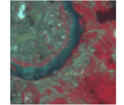
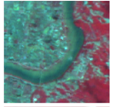
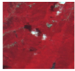
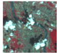
| Image | Interpretation Key | Number | Landmark |
|---|---|---|---|
 | The color of the river is dark blue or blue. It was natural bent just like banded and usually has branches. | 1 | River |
 | The flood water was dark on the image, and it is slightly yellowish compared to the rivers, lakes and other natural water bodies. | 2 | Flood |
 | Vegetation is red or dark red and its image structure is more uniform. | 3 | Vegetation |
 | Residential area has a platy texture and the river often passes through. Farmland is widely distributed around residential area which is surrounding by developed traffic. | 4 | Habitation |
4.2.2. The Calculation of Flood Depth


4.3. Housing Exposure Assessment of Kouqian Town


4.4. Vulnerability Assessment of Resident Housing in Kouqian Town
4.4.1. Vulnerability Evaluation Model of Housing of Flood


4.4.2. Depth-Loss Rate Curves of Housing in Kouqian Town


4.4.3. Grid Distribution of Housing Loss Rate in Kouqian Town


4.5. Flood Risk Evaluation of Resident Housing in Kouqian Town

4.6. Verification of Potential Loss of Housing during the Flood in Kouqian Town

5. Conclusions
- (1)
- This study used remote sensing images, DEM data and GIS technology to extract flood submerged area and depth. The results coincide with the real fieldwork results. This method could replace fieldwork, so as to save human, physical and financial resources.
- (2)
- For housing structures, buildings (multi-story) will not be destroyed under 4.5 m flood depth with a bit of losses; bungalows will not be destroyed under 1 m flood depth. The bungalows will be totally submerged if the flood depth is higher than 3 m and cause collapses. The higher the flood depth is, the larger the losses of housing structure are. When the flood depth is the same, the older the house is the larger the losses of the house are.
- (3)
- For indoor properties, when the flood depth is higher than 2 m, all the indoor property will be destroyed. There also has a positive relationship between flood depth and indoor property losses.
- (4)
- Based on the assessment of hazard, exposure and vulnerability of flood disaster, this study built s flood disaster losses fast assessment model. In different areas the disaster losses may be caused by different reasons, some may caused by large flood depth, some may caused by high housing values. The assessment result could be used in disaster management and emergence rescue.
Acknowledgments
Conflicts of Interest
References
- Yin, Z.; Xu, S.Y.; Yin, J.; Wang, J. Small-scale based scenario modeling and disaster risk assessment of urban rainstorm water-logging. Acta Geogr. Sin. 2010, 65, 11–22. [Google Scholar]
- Chen, P.; Zhang, J.; Jiang, X.; Liu, X.; Bao, Y.; Sun, Y. Scenario simulation-based assessment of trip difficulty for urban residents under rainstorm waterlogging. Int. J. Environ. Res. Public Health 2012, 9, 2057–2074. [Google Scholar] [CrossRef]
- Xu, Z.S.; Feng, K.; Feng, C.Y.; Wang, D.S. Application of VR-GIS technology to analysis and simulation of flood undulation in small towns. J. Dis. Prev. Mitig. Eng. 2004, 24, 247–251. [Google Scholar]
- Xu, Z.S.; Xu, L.; Feng, K. GIS-based system for analysis of flood inundation and emergency response decision making in small towns. China Saf. Sci. J. 2005, 15, 11–14. [Google Scholar]
- Yin, Z.G.; Ren, Y.S.; Zhou, J.H.; Liu, Y.J.; Meng, X.H. Experimental research of mechanical response on village house hit by floods. J. Catastrophol. 2010, 25, 127–130. [Google Scholar]
- Liu, Y.J.; Zhou, J.H.; Meng, X.H. Research and development of computer software for analyzing and evaluating flood actions on rural buildings. J. Inf. Technol. Civ. Eng. Archit. 2011, 3, 57–62. [Google Scholar]
- Zhang, J.Q.; Okada, N.; Tatano, H. Integrated natural disaster risk management: Comprehensive and integrated model and Chinese strategy choice. J. Nat. Dis. 2006, 15, 29–37. [Google Scholar]
- Crichton, D. The Implications of Climate Change for the Insurance Industry; Building Research Establishment: Watford, UK, 2001. [Google Scholar]
- Michael, F.; Julie, G. Urban sustainability in the presence of flood and geological hazards: The development of a GIS-based vulnerability and risk assessment methodology. Landsc. Urban Plan. 2007, 83, 50–61. [Google Scholar] [CrossRef]
- McFeeters, S.K. The use of normalized difference water index (NDWI) in the delineation of open water features. Int. J. Remote Sens. 1996, 17, 1425–1432. [Google Scholar]
- Dutta, D.; Herath, S.; Musiake, K. A mathematical model for flood loss estimation. J. Hydrol. 2003, 277, 24–49. [Google Scholar] [CrossRef]
- Kelman, I. Physical Flood Vulnerability of Residential Properties in Coastal, Eastern England. Cambridge. Ph.D Thesis, Cambridge University, Cambridge, UK, 2002. [Google Scholar]
- Feng, M.Q.; Zhou, X.D.; Zhang, G.G. Review on development of assessment of flood damage loss. Northwest Water Resour. Water Eng. 2002, 13, 32–36. [Google Scholar]
© 2014 by the authors; licensee MDPI, Basel, Switzerland. This article is an open access article distributed under the terms and conditions of the Creative Commons Attribution license (http://creativecommons.org/licenses/by/3.0/).
Share and Cite
Zhang, Q.; Zhang, J.; Jiang, L.; Liu, X.; Tong, Z. Flood Disaster Risk Assessment of Rural Housings — A Case Study of Kouqian Town in China. Int. J. Environ. Res. Public Health 2014, 11, 3787-3802. https://doi.org/10.3390/ijerph110403787
Zhang Q, Zhang J, Jiang L, Liu X, Tong Z. Flood Disaster Risk Assessment of Rural Housings — A Case Study of Kouqian Town in China. International Journal of Environmental Research and Public Health. 2014; 11(4):3787-3802. https://doi.org/10.3390/ijerph110403787
Chicago/Turabian StyleZhang, Qi, Jiquan Zhang, Liupeng Jiang, Xingpeng Liu, and Zhijun Tong. 2014. "Flood Disaster Risk Assessment of Rural Housings — A Case Study of Kouqian Town in China" International Journal of Environmental Research and Public Health 11, no. 4: 3787-3802. https://doi.org/10.3390/ijerph110403787
APA StyleZhang, Q., Zhang, J., Jiang, L., Liu, X., & Tong, Z. (2014). Flood Disaster Risk Assessment of Rural Housings — A Case Study of Kouqian Town in China. International Journal of Environmental Research and Public Health, 11(4), 3787-3802. https://doi.org/10.3390/ijerph110403787


