
Getting to Know a Place: Built Environment Walkability and Children’s Spatial Representation of Their Home-School (h–s) Route


Abstract
:1. Introduction
1.1. Spatial Knowledge
1.2. Gender Differences in Spatial Knowledge
1.3. Spatial Knowledge and the Built Environment
1.4. Spatial Knowledge, Travel Behavior and the Built Environment
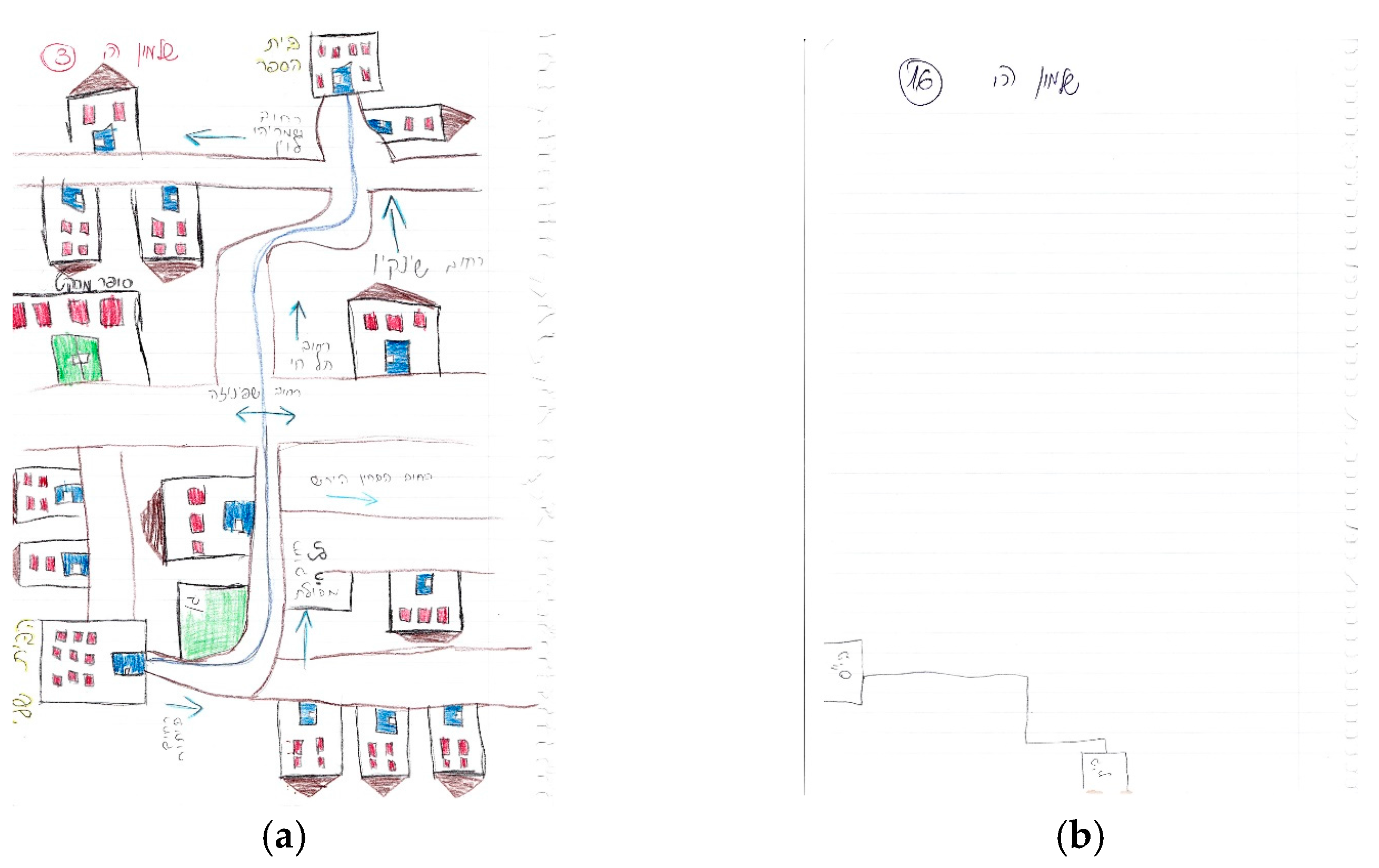
1.5. Assessing Spatial Knowledge through Sketch Maps
1.6. Current Study
- To explore children’s spatial knowledge and representation of their h–s route as obtained through their drawn sketch maps (henceforth: maps’ summary scores). Following previous studies [28,29] we distinguished between the map’s orientation and structure, and its richness, which reflect the number of details drawn in the map.
- To examine the associations between the maps’ summary scores and built environment attributes at both neighborhood and route scales. Based on the vast literature on walking and environmental walkability on the one hand, and spatial knowledge, on the other hand; we hypothesized that environmental walkability and its components will be positively associated with spatial knowledge (as represented by the maps’ scores).
- To examine the association between maps’ summary scores and school travel mode. Based on existing literature, we hypothesized that children who walk to school would have better spatial knowledge and representation of the h–s route than those who don’t.
- To examine the association between maps outcomes and gender. Based on the mixed evidence in prior research on gender and spatial knowledge, no hypothesis was made.
2. Materials and Methods
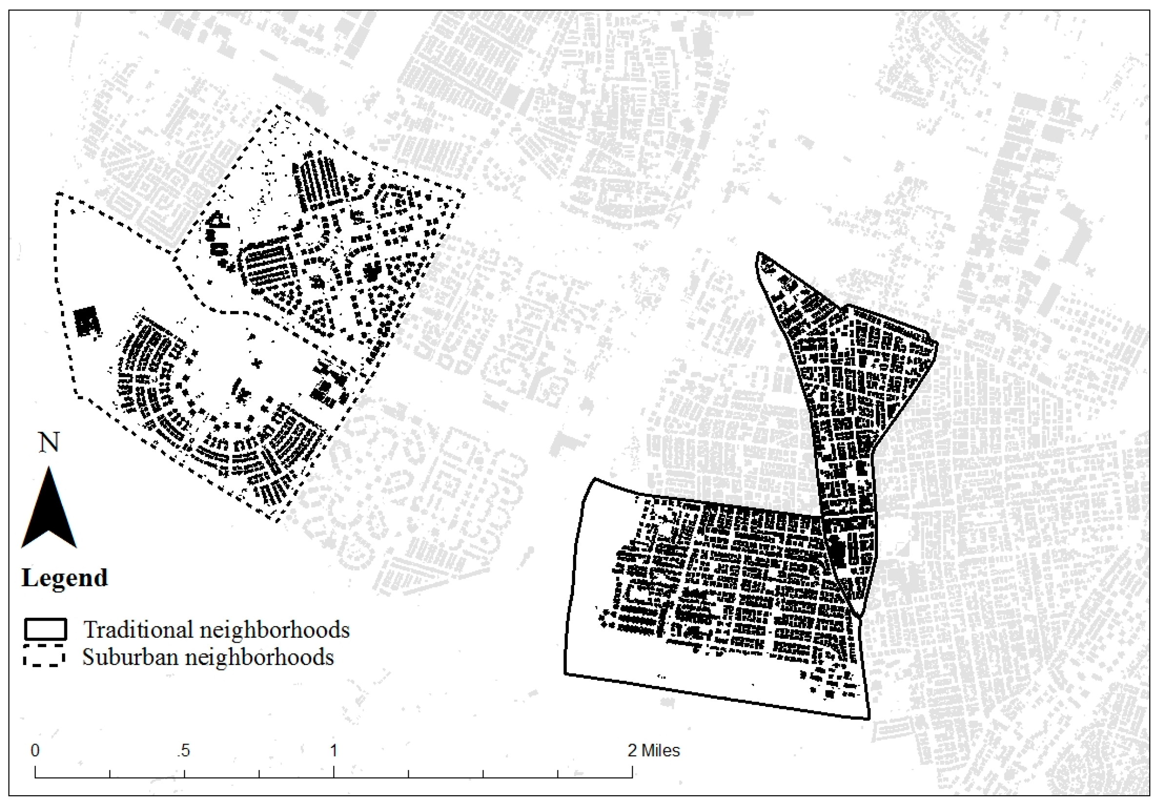
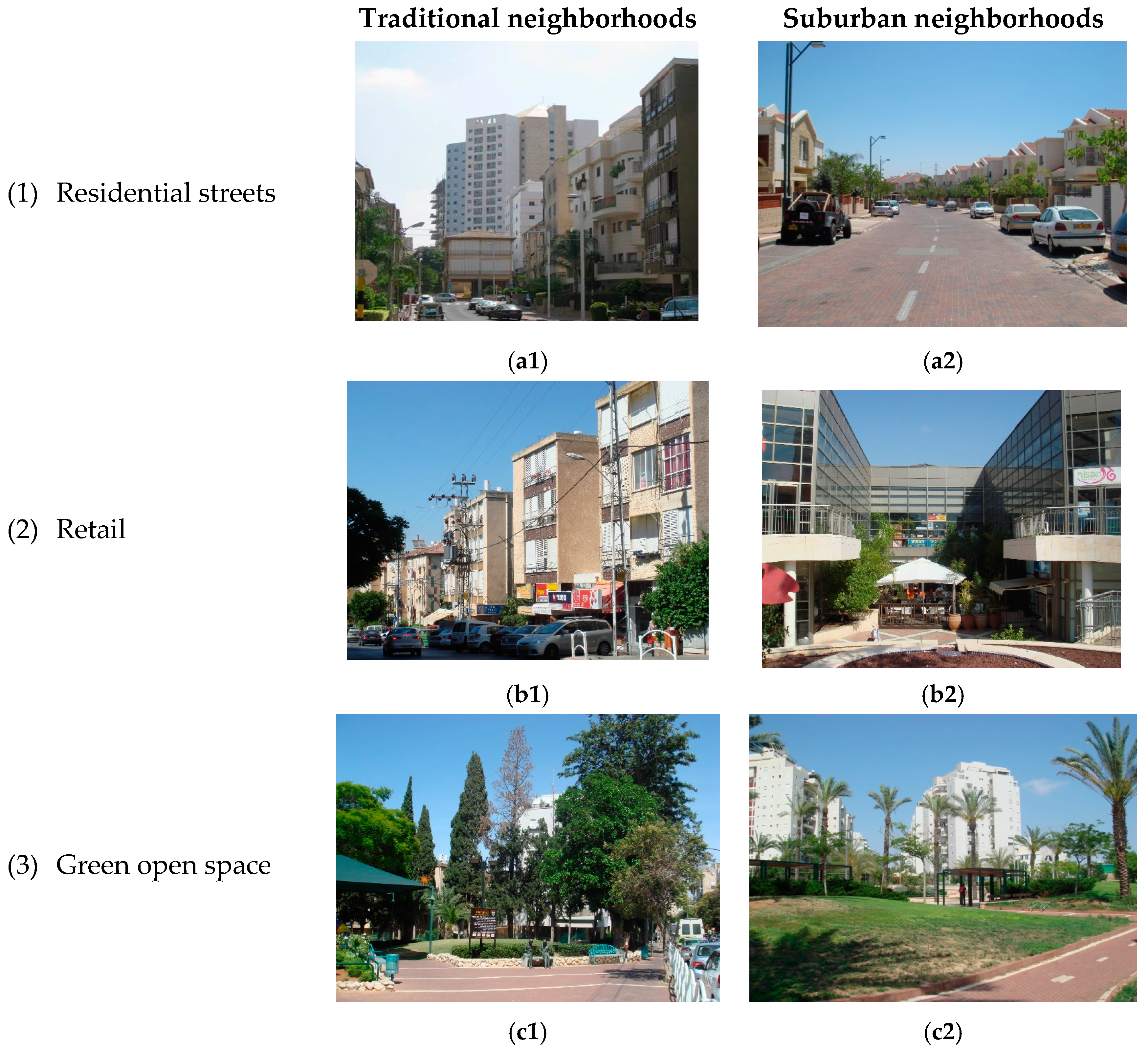
2.1. Study Area
2.2. Participants and Procedure
2.3. Constructs and Measures
2.4. Analysis Plan
3. Results
3.1. Sketch Maps’ Summary Scores in Traditional and Suburban Neighborhoods
3.2. Associations between Sketch Maps’ Summary Scores and Environmental Attributes along h–s Routes
3.3. Sketch Maps’ Summary Score by School Travel Mode
3.4. Sketch Maps’ Summary Score by Gender
3.5. Multivariate Analysis to Predict Sketch Maps’ Summary Scores
4. Discussion
5. Conclusions
Implications for Urban Planning
Acknowledgments
Author Contributions
Conflicts of Interest
References
- Lynch, K. The Image of the City; MIT Press: Cambridge, MA, USA, 1960; Volume 11. [Google Scholar]
- Moore, G.T. Knowing about environmental knowing: The current state of theory and research on environmental cognition. Environ. Behav. 1979, 11, 33–70. [Google Scholar] [CrossRef]
- O’keefe, J.; Nadel, L. The Hippocampus as a Cognitive Map; Clarendon Press: Oxford, UK, 1978. [Google Scholar]
- Appleyard, D. Styles and methods of structuring a city. Environ. Behav. 1970, 2, 100–117. [Google Scholar] [CrossRef]
- Downs, R.M.; Stea, D. Image and Environment: Cognitive Mapping and Spatial Behavior; Transaction Publishers: New Brunswick, NJ, USA, 1973. [Google Scholar]
- Lee, T. On the relation between the school journey and social and emotional adjustment in rural infant children. Br. J. Educ. Psychol. 1957, 27, 101–114. [Google Scholar] [CrossRef]
- Lee, T. Urban neighborhood as a socio-spatial schema. Human. Relat. 1968, 21, 241–267. [Google Scholar] [CrossRef]
- Heft, H. Environment, cognition, and culture: Reconsidering the cognitive map. J. Environ. Psychol. 2013, 33, 14–25. [Google Scholar] [CrossRef]
- Tversky, B. Cognitive maps, cognitive collages, and spatial mental models. In Spatial Information Theory: A Theoretical Basis for GIS, Proceedings COSIT, Marciana Marina, Elba Island, Italy, 1993; Frank, A.U., Campari, I., Eds.; Springer: Berlin, Germany, 1993; pp. 14–24. [Google Scholar]
- Gärling, T.; Böök, A.; Lindberg, E. Spatial orientation and wayfinding in the designed environment: A conceptual analysis and some suggestions for postoccupancy evaluation. J. Architect. Plan. Res. 1986, 3, 55–64. [Google Scholar]
- Vandenberg, A.E.; Hunter, R.H.; Anderson, L.A.; Bryant, L.L.; Hooker, S.; Satariano, W. Walking and walkability: Is wayfinding a missing link? Implications for public health practice. J. Phys. Act. Health 2016, 13, 189–197. [Google Scholar] [CrossRef] [PubMed]
- McCreary, F. Adult-Child Differences in Spatial Learning in an Immersive Virtual Environment as a Function of Field-of-View. Ph.D. Thesis, Virginia Tech, Blacksburg, VA, USA, 1997. [Google Scholar]
- Jansen-Osmann, P.; Fuchs, P. Wayfinding behavior and spatial knowledge of adults and children in a virtual environment: The role of landmarks. Exp. Psychol. 2006, 53, 171–181. [Google Scholar] [CrossRef] [PubMed]
- Jansen, P.; Schmelter, A.; Heil, M. Spatial knowledge acquisition in younger and elderly adults. Exp. Psychol. 2010, 57, 54–60. [Google Scholar] [CrossRef] [PubMed]
- Coluccia, E.; Iosue, G.; Brandimonte, M.A. The relationship between map drawing and spatial orientation abilities: A study of gender differences. J. Environ. Psychol. 2007, 27, 135–144. [Google Scholar] [CrossRef]
- Dabbs, J.M.; Chang, E.L.; Strong, R.A.; Milun, R. Spatial ability, navigation strategy, and geographic knowledge among men and women. Evol. Hum. Behav. 1998, 19, 89–98. [Google Scholar] [CrossRef]
- Galea, L.A.; Kimura, D. Sex differences in route-learning. Pers. Individ. Differ. 1993, 14, 53–65. [Google Scholar] [CrossRef]
- Lawton, C.A.; Charleston, S.I.; Zieles, A.S. Individual-and gender-related differences in indoor wayfinding. Environ. Behav. 1996, 28, 204–219. [Google Scholar] [CrossRef]
- Hölscher, C.; Tenbrik, T.; Wiener, J.M. Would you follow your own route description? Cognitive strategies in urban planning. Cognition 2006, 121, 228–247. [Google Scholar] [CrossRef] [PubMed]
- Gibbs, A.C.; Wilson, J.F. Sex differences in route learning by children. Percept. Mot. Skills 1999, 88, 590–594. [Google Scholar] [CrossRef] [PubMed]
- Jansen-Osmann, P.; Wiedenbauer, G. The representation of landmarks and routes in children and adults: A study in a virtual environment. J. Environ. Psychol. 2004, 24, 347–357. [Google Scholar] [CrossRef]
- Cubukcu, E.; Nasar, J.L. Relation of physical form to spatial knowledge in largescale virtual environments. Environ. Behav. 2005, 37, 397–417. [Google Scholar] [CrossRef]
- Siegel, A.W.; White, S.H. The development of spatial representations of large-scale environments. Adv. Child Dev. Behav. 1975, 10, 9–55. [Google Scholar] [PubMed]
- Goldbeck, S.L. Spatial cognition as a function of environmental characteristics. In The Development of Spatial Cognition; Cohen, R., Ed.; Lawrence Erlbaum: Hillsdale, NJ, USA, 1985; pp. 225–254. [Google Scholar]
- Cohen, S.; Cohen, R. The role of activity in spatial cognition. In The Development of Spatial Cognition; Cohen, R., Ed.; Lawrence Erlbaum: Hillsdale, NJ, USA, 1985; pp. 199–223. [Google Scholar]
- Hart, R. Children’s Experience of Place; Irvington: New York, NY, USA, 1979. [Google Scholar]
- Ahmadi, E.; Taniguchi, G. Influential factors on children’s spatial knowledge and mobility in home-school travel: A case study in the city of Tehran. J. Asian Architect. Build. Eng. 2007, 6, 275–282. [Google Scholar] [CrossRef]
- Rissotto, A.; Tonucci, F. Freedom of movement and environmental knowledge in elementary school children. J. Environ. Psychol. 2002, 22, 65–77. [Google Scholar] [CrossRef]
- Frank, L.D.; Sallis, J.F.; Saelens, B.E.; Leary, L.; Cain, K.; Conway, T.L.; Hess, P.M. The development of a walkability index: Application to the neighborhood quality of life study. Br. J. Sports Med. 2010, 44, 924–933. [Google Scholar] [CrossRef] [PubMed]
- Sallis, J.F.; Cervero, R.B.; Ascher, W.; Henderson, K.A.; Kraft, M.K.; Kerr, J. An ecological approach to creating active living communities. Ann. Rev. Public Health 2006, 27, 297–322. [Google Scholar] [CrossRef] [PubMed]
- Giles-Corti, B.; Wood, G.; Pikora, T.; Learnihan, V.; Bulsara, M.; Van Niel, K.; Timperio, A.; McCormack, G.; Villanueva, K. School site and the potential to walk to school: The impact of street connectivity and traffic exposure in school neighborhoods. Health Place 2011, 17, 545–550. [Google Scholar] [CrossRef] [PubMed]
- Kerr, J.; Rosenberg, D.; Sallis, J.F.; Saelens, B.E.; Frank, L.D.; Conway, T.L. Active commuting to school: Associations with environment and parental concerns. Med. Sci. Sports Exerc. 2006, 38, 787. [Google Scholar] [CrossRef] [PubMed]
- Panter, J.R.; Jones, A.P.; Van Sluijs, E.M.; Griffin, S.J. Neighborhood, route, and school environments and children’s active commuting. Am. J. Prev. Med. 2010, 38, 268–278. [Google Scholar] [CrossRef] [PubMed]
- Timperio, A.; Ball, K.; Salmon, J.; Roberts, R.; Giles-Corti, B.; Simmons, D.; Baur, L.A.; Crawford, D. Personal, family, social, and environmental correlates of active commuting to school. Am. J. Prev. Med. 2006, 30, 45–51. [Google Scholar] [CrossRef] [PubMed]
- Hanibuchi, T.; Nakaya, T.; Yonejima, M.; Honjo, K. Perceived and objective measures of neighborhood walkability and physical activity among adults in Japan: A multilevel analysis of a nationally representative sample. Int. J. Environ. Res. Public Health 2015, 12, 13350–13364. [Google Scholar] [CrossRef] [PubMed]
- Reyer, M.; Fina, S.; Siedentop, S.; Schlicht, W. Walkability is only part of the story: Walking for transportation in Stuttgart, Germany. Int. J. Environ. Res. Public Health 2014, 11, 5849–5865. [Google Scholar] [CrossRef] [PubMed]
- Zuniga-Teran, A.A.; Orr, B.J.; Gimblett, R.H.; Chalfoun, N.V.; Guertin, D.P.; Marsh, S.E. Neighborhood design, physical activity, and wellbeing: Applying the walkability model. Int. J. Environ. Res. Public Health 2017, 14, 76. [Google Scholar] [CrossRef] [PubMed]
- Ewing, R.; Handy, S.; Brownson, R.C.; Clemente, O.; Winston, E. Identifying and measuring urban design qualities related to walkability. J. Phys. Act. Health 2006, 3, S223. [Google Scholar] [CrossRef]
- Ewing, R.; Handy, S. Measuring the unmeasurable: Urban design qualities related to walkability. J. Urban Des. 2009, 14, 65–84. [Google Scholar] [CrossRef]
- Campbell, J.I.; Hepner, I.J.; Miller, L.A. The influence of age and sex on memory for a familiar environment. J. Environ. Psychol. 2014, 40, 1–8. [Google Scholar] [CrossRef]
- Boschmann, E.E.; Cubbon, E. Sketch maps and qualitative GIS: Using cartographies of individual spatial narratives in geographic research. Prof. Geog. 2014, 66, 236–248. [Google Scholar] [CrossRef]
- Pavlovskaya, M. Critical GIS and its positionality. Cartographica 2009, 44, 8–10. [Google Scholar]
- Liben, L.S. Spatial representation and behavior: Multiple perspectives. In Spatial Representation and Behavior across the Life Span: Theory and Application; Academic Press: New York, NY, USA, 1981; pp. 3–32. [Google Scholar]
- Thorndyke, P.W.; Hayes-Roth, B. Differences in spatial knowledge acquired from maps and navigation. Congn. Psychol. 1982, 14, 560–589. [Google Scholar] [CrossRef]
- Blades, M. The reliability of data collected from sketch maps. J. Environ. Psychol. 1990, 10, 327–339. [Google Scholar] [CrossRef]
- Rovine, M.J.; Weisman, G.D. Sketch-map variables as predictors of way-finding performance. J. Environ. Psychol. 1989, 9, 217–232. [Google Scholar] [CrossRef]
- Holt, N.L.; Spence, J.C.; Sehn, Z.L.; Cutumisu, N. Neighborhood and developmental differences in children’s perceptions of opportunities for play and physical activity. Health Place 2008, 14, 2–14. [Google Scholar] [CrossRef] [PubMed]
- Moran, M.R.; Plaut, P.; Baron-Epel, O. Do children walk where they bike? Exploring built environment correlates of children’s walking and bicycling. JTLU 2016, 9, 43–65. [Google Scholar] [CrossRef]
- ICBS. Motor Vehicles per 1000 Residents by Type; Israel Central Bureau of Statistics: Jerusalem, Israel, 2014. Available online: http://www.rishonlezion.muni.il/meida/Stats/Documents/2015/6.0.3.pdf (accessed on 21 May 2017).
- ICBS. Society in Israel, Report Number 7, the Large Cities at a Glance; Israel Central Bureau of Statistics: Jerusalem, Israel, 2014; (In Hebrew). Available online: http://www.cbs.gov.il/publications14/rep_07/pdf/part06_h.pdf (accessed on 21 May 2017).
- Moran, M. The Relationship between the Built Environment and Active Living. Ph.D. Thesis, Technion—Israel Institute of Technology, Haifa, Israel, 2013. [Google Scholar]
- ICBS. Israel’s Crime Victimization Survey 2014; Israel Central Bureau of Statistics: Jerusalem, Israel, 2014; (In Hebrew). Available online: http://www.cbs.gov.il/publications15/victim14_1614/pdf/h_print.pdf (accessed on 21 May 2017).
- Freeman, L.; Neckerman, K.; Schwartz-Soicher, O.; Quinn, J.; Richards, C.; Bader, M.D.; Lovasi, G.; Jack, D.; Weiss, C.; Konty, K. Neighborhood walkability and active travel (walking and cycling) in New York city. J. Urban Health 2013, 90, 575–585. [Google Scholar] [CrossRef] [PubMed]
- French, S.; Wood, L.; Foster, S.A.; Giles-Corti, B.; Frank, L.; Learnihan, V. Sense of community and its association with the neighborhood built environment. Environ. Behav. 2014, 46, 677–697. [Google Scholar] [CrossRef]
- Berke, E.M.; Gottlieb, L.M.; Moudon, A.V.; Larson, E.B. Protective association between neighborhood walkability and depression in older men. J. Am. Geriatric. Soc. 2007, 55, 526–533. [Google Scholar] [CrossRef] [PubMed]
- Rissotto, A.; Giuliani, V. Learning neighbourhood environments: The loss of experience in a modern world. In Children and Their Environments: Learning, Using and Designing Spaces; Spencer, C., Blades, M., Eds.; Cambridge University Press: Cambridge, UK, 2006. [Google Scholar]
- Änggård, E. How matter comes to matter in children’s nature play: Post humanist approaches and children’s geographies. Child. Geogr. 2015, 14, 77–90. [Google Scholar] [CrossRef]
- Waters, J.; Maynard, T. What’s so interesting outside? A study of child-initiated interaction with teachers in the natural outdoor environment. Eur. Early Child. Educ. Res. J. 2010, 18, 473–483. [Google Scholar] [CrossRef]
- Lamb, R.J.; Purcell, A.T. Perception of naturalness in landscape and its relationship to vegetation structure. Landsc. Urban Plan. 1990, 19, 333–352. [Google Scholar] [CrossRef]
- Lee, S.W.; Ellis, C.D.; Kweon, B.S.; Hong, S.K. Relationship between landscape structure and neighborhood satisfaction in urbanized areas. Landsc. Urban Plan. 2008, 85, 60–70. [Google Scholar] [CrossRef]
- The National Council for Planning and Building. National Outline Plan for Construction, Development and Conservation (NOP 35). Available online: http://www.mmi.gov.il/IturTabotData/tma/%D7%AA%D7%9E%D7%90%2035/tama_35.pdf (accessed on 29 May 2017).
- Janssen, I.; Katzmarzyk, P.T.; Boyce, W.F.; Vereecken, C.; Mulvihill, C.; Roberts, C.; Currie, C.; Pickett, W. Comparison of overweight and obesity prevalence in school-aged youth from 34 countries and their relationships with physical activity and dietary patterns. Obes. Rev. 2005, 6, 123–132. [Google Scholar] [CrossRef] [PubMed]
- Lissau, I.; Overpeck, M.D.; Ruan, W.J.; Due, P.; Holstein, B.E.; Hediger, M.L. Body mass index and overweight in adolescents in 13 European countries, Israel, and the United States. Arch. Pediatr. Adolesc. Med. 2004, 158, 27–33. [Google Scholar] [CrossRef] [PubMed]


| Conceptual Definition | Operational Definition | Data Source | |
|---|---|---|---|
| Dependent Variables | Spatial declarative knowledge | Orientation and structure summary score | maps drawn by participants |
| Richness summary score | maps drawn by participants | ||
| Independent variables | Neighborhood type | Traditional/Suburban | GIS |
| Built environment en-route to school | Environmental variables along h–s route (within 25 m buffer):
| GIS | |
| School travel mode | Walking to school most of the week (at least 3 days—yes/no) | Self-report | |
| Gender | Boy/Girl | Self-report |
| Overall Sample (N = 92) | Traditional Neighborhoods (N = 52) | Suburban Neighborhoods (N = 40) | |||||||
|---|---|---|---|---|---|---|---|---|---|
| Mean (SD) | IQR | Mean (SD) | IQR | Mean (SD) | IQR | T | Df | p | |
| Walkability Index | 0.28 (1.48) | −0.97–1.34 | 1.14 (1.18) | 0.25–1.92 | −0.83 (1.03) | −1.45–−0.35 | −8.00 | 90 | <0.0001 |
| Urban form measures | |||||||||
| Street connectivity (intersections/sq km) | 9.7 (5.13) | 6.55–11.89 | 10.56 (3.93) | 7.65–12.46 | 8.56 (6.24) | 4.90–10.68 | −1.67 | 90 | 0.18 |
| Residential density (households/sq km) | 15.44 (8.22) | 7.11–21.76 | 21.61 (5.16) | 18.19–23.94 | 7.42 (2.52) | 5.51–9.79 | −16.45 | 90 | <0.0001 |
| Land use measures | |||||||||
| % Retail area | 0.05 (0.07) | 0.00–0.10 | 0.08 (0.08) | 0.01–0.12 | 0.00 (0.02) | 0.00–0.001 | −5.11 | 90 | <0.0001 |
| % Public Institute area | 0.22 (0.15) | 0.10–0.30 | 0.20 (0.11) | 0.10–0.27 | 0.23 (0.19) | 0.08–0.34 | 1.03 | 90 | 0.31 |
| % Green Open Space | 0.10 (0.12) | 0.01–0.16 | 0.02 (0.04) | 0.00–0.03 | 0.19 (0.13) | 0.08–0.31 | 9.25 | 90 | <0.0001 |
| Total Sample (N = 92) | Neighborhood Type | School Travel Mode | Gender | ||||||||||
|---|---|---|---|---|---|---|---|---|---|---|---|---|---|
| Trad’ (N = 52) | Suburban (N = 40) | χ2 | T | Walk (N = 52) | Other (N = 40) | χ2 | T | Boy (N = 52) | Girl (N = 40) | χ2 | T | ||
| Orientation † | |||||||||||||
| Inaccurately-oriented (0) | 6 (7%) | 3 (6%) | 3 (8%) | 1.99 | NA | 3 (5%) | 3 (10%) | 3.21 | NA | 1 (2%) | 5 (10%) | 2.45 | NA |
| Partially-oriented (1) | 28 (30%) | 13 (25%) | 15 (37%) | 17 (27%) | 11 (40%) | 13 (29%) | 15 (31%) | ||||||
| Accurately-oriented (2) | 58 (63%) | 36 (69%) | 22 (55%) | 44 (68%) | 14 (50%) | 36 (67%) | 29 (59%) | ||||||
| Structure | 1.36 (0–9) | 0.83 (0–5) | 2.05 (0–9) | NA | −3.41 * | 0.95 (0–5) | 2.29 (0–9) | NA | 3.46 * | 0.95 (0–5) | 1.71 (0–9) | NA | 2.06 * |
| Gap in segments [M(range)] | |||||||||||||
| OR | |||||||||||||
| Perfect match (no gap) | 38 (41%) | 32 (62%) | 6 (15%) | 20.20 *** | NA | 32 (50%) | 6 (21%) | 6.56 * | NA | 19 (44%) | 19 (39%) | 0.28 | NA |
| Gap of 1 segment or more | 54 (59%) | 20 (38%) | 34 (85%) | 32 (50%) | 22 (79%) | 24 (56%) | 30 (61%) | ||||||
| Summary score | 8.23 (1–10) | 8.81 (3–10) | 7.48 (1–10) | NA | 3.46 ** | 8.69 (3–10) | 7.18 (1–10) | NA | 3.66 ** | 8.70 (3–10) | 7.82 (1–10) | NA | −2.22 ** |
| orientation and structure [M(range)] | |||||||||||||
| Richness | |||||||||||||
| Diversity | 2.23 (0–6) | 2.15 (0–6) | 2.33 (0–5) | NA | −0.64 | 2.11 (0–5) | 2.50 (1–6) | NA | 1.44 | 1.98 (0–4) | 2.45 (0–6) | NA | 1.81 * |
| Number of themes [M(range)] | |||||||||||||
| Level of detail | 3.35 (0–11) | 3.29 (0–11) | 3.43 (0–7) | NA | −0.30 | 3.29 (0–11) | 3.43 (1–10) | NA | 0.3 | 2.91 (0–7) | 3.73 (0–11) | NA | 1.89 * |
| Number of elements [M(range)] | |||||||||||||
| Summary score | 5.58 (0–16) | 5.44 (0–16) | 5.75 (0–11) | NA | −0.45 | 5.23 (0–13) | 6.36 (2–16) | NA | 1.57 | 4.88 (0–11) | 6.18 (0–16) | NA | 1.96 * |
| Diversity and detail [M(range)] | |||||||||||||
| Sketch Maps’ Summary Scores- | |||||
|---|---|---|---|---|---|
| Orientation and Structure | Richness | ||||
| R | p | R | p | ||
| Walkability index | 0.40 *** | 0.000 | −0.03 | 0.81 | |
| Urban form | Residential density | 0.35 * | 014.0 | −0.12 | 0.25 |
| Intersection density | 0.30 *** | 000.0 | −0.02 | 0.86 | |
| Land use | % retail | 0.22 * | 03.0 | 0.08 | 44 |
| % public institutes | −0.009 | 0.09 | 0.07 | 52 | |
| % green open space | −0.21 * | 0.03 | 0.05 | 62 | |
| Independent variables | Orientation and Structure Summary Score | |
|---|---|---|
| β | p | |
| Route distance | −0.33 | 0.005 |
| Gender (boy vs. girl) | 0.23 | 0.022 |
| Walking to school (number of days per week) | 0.20 | 0.05 |
| Neighborhood type | 0.06 | 0.60 |
| Model summary | R² = 0.30, p < 0.0001, N = 92 | |
© 2017 by the authors. Licensee MDPI, Basel, Switzerland. This article is an open access article distributed under the terms and conditions of the Creative Commons Attribution (CC BY) license (http://creativecommons.org/licenses/by/4.0/).
Share and Cite
Moran, M.R.; Eizenberg, E.; Plaut, P. Getting to Know a Place: Built Environment Walkability and Children’s Spatial Representation of Their Home-School (h–s) Route. Int. J. Environ. Res. Public Health 2017, 14, 607. https://doi.org/10.3390/ijerph14060607
Moran MR, Eizenberg E, Plaut P. Getting to Know a Place: Built Environment Walkability and Children’s Spatial Representation of Their Home-School (h–s) Route. International Journal of Environmental Research and Public Health. 2017; 14(6):607. https://doi.org/10.3390/ijerph14060607
Chicago/Turabian StyleMoran, Mika R., Efrat Eizenberg, and Pnina Plaut. 2017. "Getting to Know a Place: Built Environment Walkability and Children’s Spatial Representation of Their Home-School (h–s) Route" International Journal of Environmental Research and Public Health 14, no. 6: 607. https://doi.org/10.3390/ijerph14060607