1. Introduction
The Yellow-River-Source National Park (YRSNP) is located in the hinterland of the Tibetan Plateau at the source of the Yellow River, and is an important supply area for freshwater resources in China [
1]. This region is one of the richest biodiversity areas and constitutes a sensitive zone for climate change in the Northern Hemisphere as well as globally [
2,
3]. Its unique geographical location, rich natural resources, and important ecological functions have enabled it to become an important ecological security barrier in China [
4,
5]. However, overgrazing, grassland degradation, seasonal imbalances, and other developmental bottlenecks in the traditional animal husbandry industry in this region have severely threatened the maintenance of grassland ecosystem services and functions [
6,
7,
8]. This location is an ideal example of this conflict. The establishment of the national park system has enabled an effective conservation of wild animals in the park and facilitated the rapid recovery of population numbers, which has resulted in increased competition with livestock for forage grass, and has even had some impact on the local grassland ecosystem and animal husbandry industry [
9]. However, the number of large wild herbivore populations, their distribution patterns in the region, and their effects on the animal husbandry industry are still unknown. The effectivity of wild animal conservation in the region is thus unclear.
Survey methods for large herbivore populations include ground surveys and remote sensing surveys. Ground surveys are simple and easy to carry out but have high costs, are time-consuming, and cannot be frequently conducted in a large area. In addition, the habitats of herbivorous animals are usually in rugged terrain that is inaccessible. Sampling survey results cannot accurately reflect the number and variation rate of animal habitats and often lacks precise spatial positional information [
10,
11]. Remote sensing surveys mainly employ manned planes and unmanned aerial vehicles (UAVs) for aerial photography to record individuals. Of these two methods, the UAV platform has a lower cost, more flexible operation, and provides a high resolution, which has rendered it a new and effective method for studying animal diversity [
12]. In terms of herbivore population size estimation, the time cost of UAV surveying is far lower than that of ground surveying. Currently, UAV-based animal surveys mainly focus on examining the possibility and detection rate of species recognition as well as the factors affecting species recognition. Animals that have been monitored using UAVs include caribou [
13], elephants in Western Africa [
14], rhinoceroses [
15], and black bears [
16], but the survey areas in these studies were all smaller than 30 km
2. In addition to the direct monitoring of animal data and distribution, UAVs can enable detailed access to habitat information for habitat studies of different animals, such as koalas and chimpanzees [
17,
18]. Some studies have also evaluated the disturbances caused by UAV monitoring on wild animals [
19,
20].
Research on the forage–livestock balance has mainly focused on pasture yield, livestock feed intake, pasture utilization rate, and livestock carrying capacity calculations [
21,
22,
23,
24,
25,
26]. Thapa et al. [
27] used livestock numbers to calculate the livestock carrying capacity of land resources in the southern mountains of Nepal. Silori et al. [
28] noted that the increasing number of livestock in southern India has disturbed the habitat of large mammals in the Mudumalai Wildlife Sanctuary. Zhang et al. [
29] used remote sensing to estimate the forage yields and livestock carrying capacities of different types of grasslands in the Three-River Source region and found that there were 6.52 million overgrazing sheep units in that region in 2010. Fan et al. [
30] used the Global Production Efficiency Model (GLO-PEM) model to calculate forage yield and grazing pressure, and results indicated that climate change is the main factor affecting forage yield in the Three-River Source region, with different grazing management models similarly affecting forage yield. Cai et al. [
31] showed that ecological livestock reduction projects in Madoi County have reversed grassland degradation in some areas. There are few reports on the effects of ecological protection and management policies on the forage–livestock balance in grasslands with high numbers of wild herbivores in China.
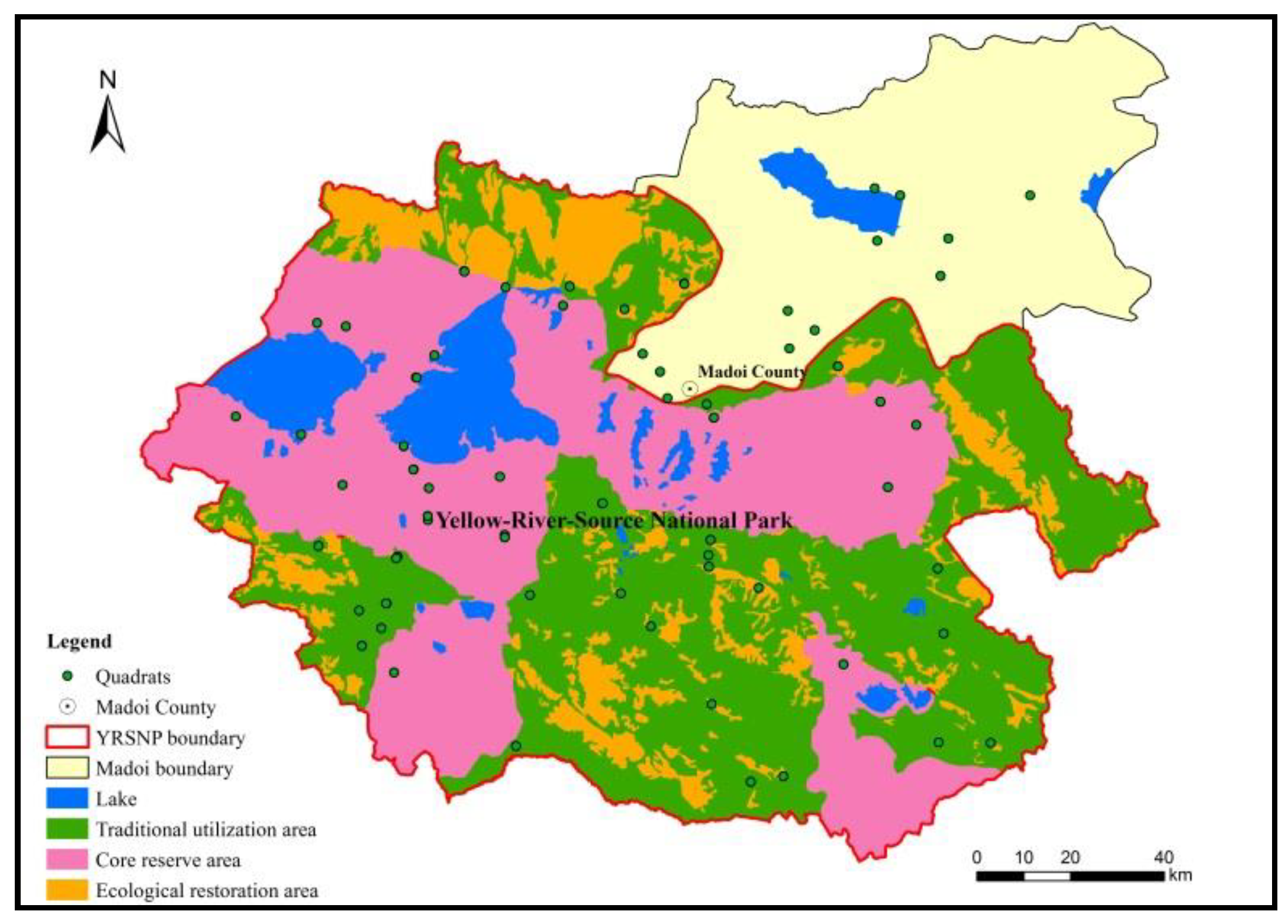
Within the YRSNP, pasture is at the supply end, while large wild herbivorous animals and human grazing activity are at the consumption end of the spectrum. These three factors reflect the coupled human–land relationship of the supply and consumption of ecosystem services. The quantitative characterization and elucidation of the coupled relationship between grasslands, wild animals, and livestock populations are required for the long-term sustainability of Tibetan gazelles for both the national park and local residents. In this study, UAV aerial photography, ground surveying, and other techniques were used to estimate the number of large herbivore populations inside the park and to analyze their distribution patterns. This was done to facilitate the scientific and rational conservation of wild animals, obtain accurate estimates of the forage–livestock balance (which includes wild animals and livestock), and analyze the effects of relevant policies and plans on the forage–livestock balance. This will allow for the effective adjustment of grassland resource utilization plans and will provide a scientific basis for the maintenance of grassland ecosystem cycles, thus promoting the construction of nature reserves and national parks in the Three-River Source region.
4. Discussion
Conventional forage–livestock balance research has mainly focused on livestock feed intake, pasture yield, grassland availability, proportion of edible pastures, and livestock carrying capacity [
47,
48,
49]. It has only used statistical data of livestock to estimate the actual livestock carrying capacity. However, wild herbivorous animals have a large body size, with an individual feed intake that is not less than cows, sheep, or other livestock; for instance, the daily feed intake of one kiang is equivalent to four sheep units. Therefore, if wild herbivorous animals are not included in the calculations of grazing pressure, the actual grazing pressure of grasslands can be easily underestimated. Yang et al. [
50] found that grazing pressure was underestimated by 22% when the number of wild herbivorous animals was not considered in studies in Madoi county in the Three-Rivers Source region.
However, large wild herbivores usually avoid humans and have low densities, so uncertain activity ranges and are easily concealed and it can be difficult to obtain accurate and real-time information on population numbers. UAV platforms not only compensate for this deficiency, but help overcome the limitations of conventional remote sensing technology at temporal and spatial resolutions. These platforms can directly monitor animal data and distributions, demonstrating unique advantages in animal diversity studies, particularly surveys on the population numbers of large animals and animal conservation. Despite these advantages, UAV remote sensing still has some limitations in animal diversity research. For instance, the load carried by UAVs is low, and it is difficult to integrate multiple sensors in the same platform for observation, which is currently still primarily based on optical cameras. Due to battery capacity limitations, UAVs can only stay in the air for a short period of time, and thus are unable to perform long-term monitoring of wild animals. In addition, the area monitored is smaller than other remote sensing platforms. In contrast to areas with unobstructed views, such as grasslands, it is difficult to directly obtain species information in forests [
51].
Over the last 60 years, the number of livestock in the Tibetan Plateau has increased by around five-fold, peaking in the 1970s and showing a slight decrease in the 1990s [
52]. However, the base number of livestock is still large (
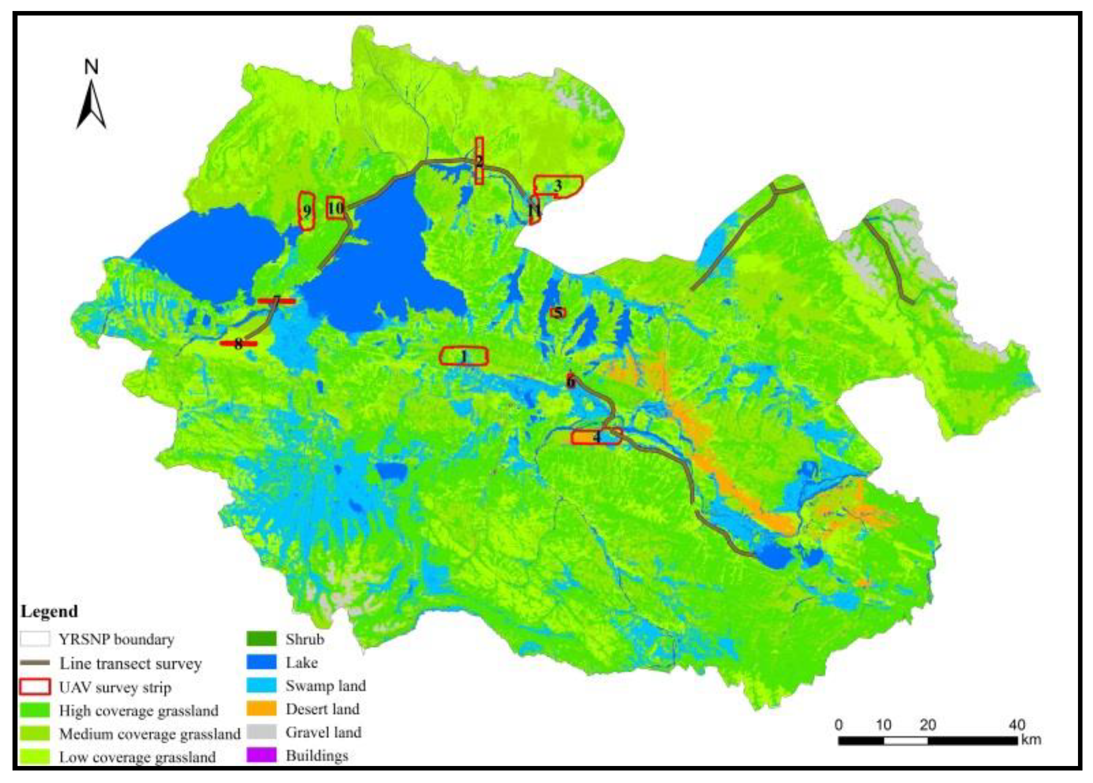
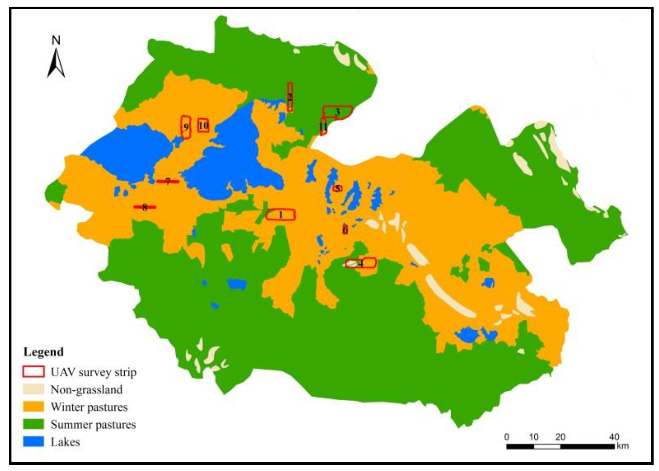
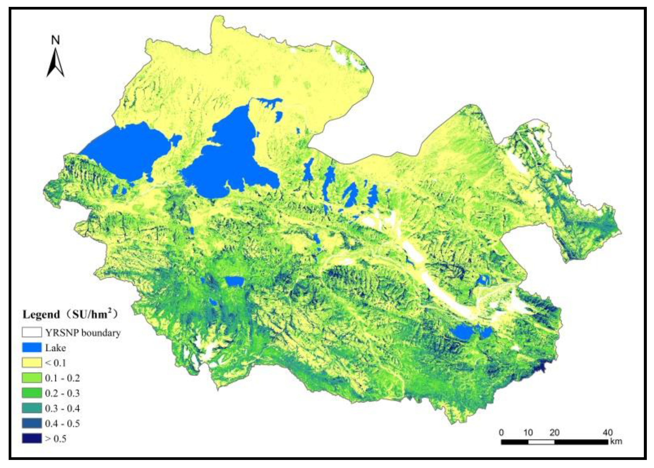
Figure 9). Since the implementation of the Three-River Source Region Ecological Project in 2005, the number of livestock in Madoi county has decreased from 608,000 sheep units to 389,000 sheep units, corresponding to a significant livestock reduction rate of 36%. However, the Three-River Source National Nature Reserve Masterplan clearly stated that the number of wild animal populations should be increased by 20% in 2020 while maintaining the forage–livestock balance. This means that competition between large populations of wild herbivores and domestic animals for resources in YRSNP will increase, and thus grazing pressure will also increase. Therefore, livestock grazing management still constitutes a major issue. In this survey, the UAV flew 191.11 km
2 in core reserve areas such as the Gyaring Lake, Ngoring Lake, and Xingxing Sea, where it found 4389 sheep units of livestock, with a density of 22.97 sheep units/km
2. This differed only slightly from the livestock density in non-core reserve areas (25.78 sheep units/km
2). This shows that although core reserve areas do not allow grazing and other human activities, they still contain large numbers of livestock, which directly reduces the available space for wild animals.
The grassland animal husbandry industry, which mainly involves grazing, is a key factor influencing the functioning of alpine steppes. Overgrazing and seasonal imbalances caused by traditional animal husbandry severely threaten the maintenance of ecosystem services [
53,
54]. There is a need therefore for tailored conservation management measures for the three different functional zones. For example, compensation should be paid to herders for losses associated with livestock reduction in traditional utilization areas as a result of wildlife conservation. In addition, the duration of livestock grazing should be reduced, and the seasonal suspension of grazing and rotational grazing should be implemented. The appropriate development of new intelligent ecological animal husbandry models with a goal of “reducing pressure and increasing efficiency” could be used to increase the economic value of livestock. An emphasis on the maintenance of natural ecological processes should be carried out in core reserve areas. Strict prohibition measures should be adopted to limit and reduce various types of human activities. Monitoring of wildlife and their habitats should be strengthened, and changes in animal populations and quantity should be closely tracked. Ecological restoration areas should focus on natural restoration and should develop necessary artificial interventions to accelerate the restoration of degraded grasslands and strengthen ecological monitoring and periodic evaluation.
Various limitations were noted in the present study. During the 2016 warm season, the resolution of the UAV aerial photography was only 15–18.5 cm, and only larger animals could be identified. In addition, distinguishing between herds of kiangs and domestic yaks proved challenging. In the 2017 cold season, the high degree of overlap between the UAV aerial photography images influenced the flight efficiency, which increased the image processing workload. When UAVs are used for surveys of large herbivores in the future, the image resolution should be increased as much as possible (optimal: 4–5 cm), while flight efficiency and fore-and-aft overlap and side overlap should be reduced as much as possible. With regards to image information extraction, HCI interpretation was only used to obtain the number and location of animals, and animal dimensions and other information were not accurately extracted. In the later stages, the characteristic morphology and biological characteristics of animals in the UAV images were considered, and computerized automatic recognition algorithms were used to achieve the automatic interpretation of animals, and to extract animal size and other characteristics to deduce the internal population structure at the species-level. In addition, wild animals migrate, and thus the monitoring of wild animals is subject to spatiotemporal effects. Conventional large-scale monitoring can reveal the variation patterns of population numbers and the associated driving mechanisms. Therefore, the number of wild animal populations should be continuously monitored. Furthermore, the role predators have played in the dynamics of these wild and domestic populations remains to be further studied [
55,
56].
5. Conclusions
In this paper, UAV flight sample strip survey results and pasture distribution data of cold and warm seasons in YRSNP were used to estimate the numbers of large herbivorous animal populations and analyze the effects of functional zone delineation in national parks on the forage–livestock balance.
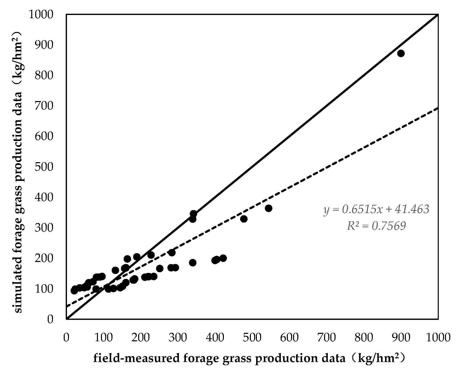
Aerial photography surveys of large herbivorous animals in YRSNP were conducted under the guidance of the Technical Guidelines for the 2nd National Survey of Terrestrial Wildlife Resources and the National Terrestrial Wildlife Resource Survey and Monitoring Technical Guidelines issued by the State Forestry and Grassland Administration. After image stitching and HCI interpretation, large herbivores were identified in the UAV aerial photography sample strip regions in the cold season. The density of kiangs and Tibetan gazelles obtained by the UAV surveys was generally consistent with the line transect survey method. The density of domestic yaks, Tibetan sheep, and horses was accurately investigated.
The type and quantity of large herbivores obtained by the UAV sample strip surveys were combined with data on the characteristics of the wild animals and cold and warm season pasture distribution data. This was done for spatial statistical analysis and to achieve a scientific estimate of the relative number of individuals based on the regional inference of the absolute number of individuals in the sample strips. This was used for comparison and validation with the statistical data and warm season survey results. The numbers of kiangs, Tibetan gazelles, domestic yaks, Tibetan sheep, and horses were estimated, and the total number of sheep units for large wild herbivores and livestock was calculated, with the ratio of large wild herbivores to livestock by sheep units being 1:5.
Large wild herbivores have different preferences for functional zones, positively selecting ecological restoration areas. These areas consist mainly of degraded grassland with low forage yields. Therefore, there is a need to strengthen the monitoring of wild animals and their habitats in these areas, conduct periodic evaluations, implement strict forage–livestock balance regulations, carry out seasonal suspensions of grazing and rotational grazing, and implement remediation for severely degraded grasslands.
The partitioning of functional zones in national parks has significant effects on the forage–livestock balance in YRSNP. After the implementation of the plan, and without reducing the number of livestock, there still existed an overloading of grassland in YRSNP. Grazing pressure increased one-fold, and forage–livestock conflict became more pronounced. Long-term mechanisms for the forage-livestock balance could promote grassland ecological improvement. Under the premise of ensuring stable numbers of wild herbivorous animals, a livestock reduction of 45% is required to ensure forage–livestock balance in the national park. In contrast to a reduction, other methods such shifting use to other grazing areas could be taken into consideration.


