
Design of Nature Tourism Route in Chimborazo Wildlife Reserve, Ecuador

 ,
,  ,
,  ,
, 

Abstract
:1. Introduction
2. Materials and Methods
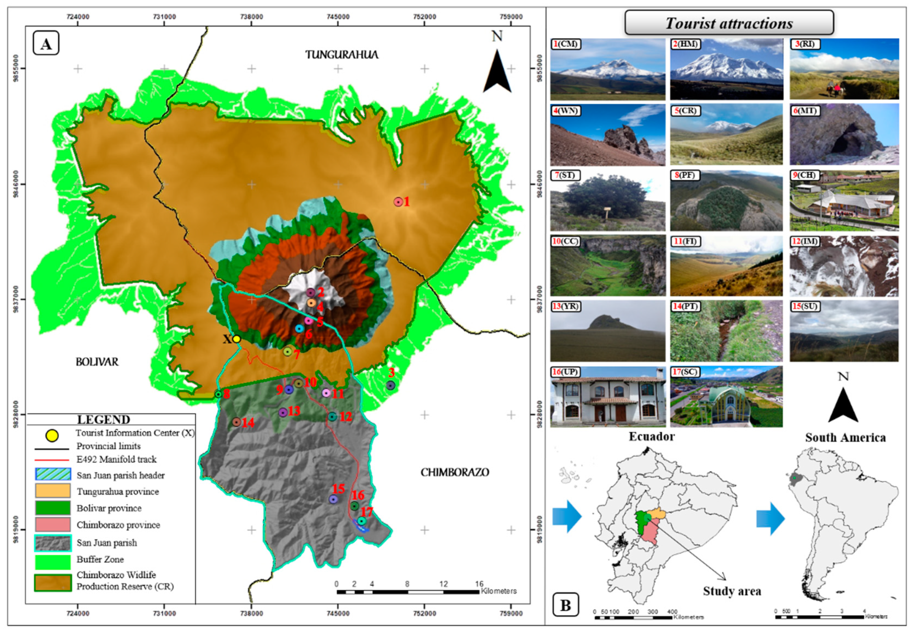
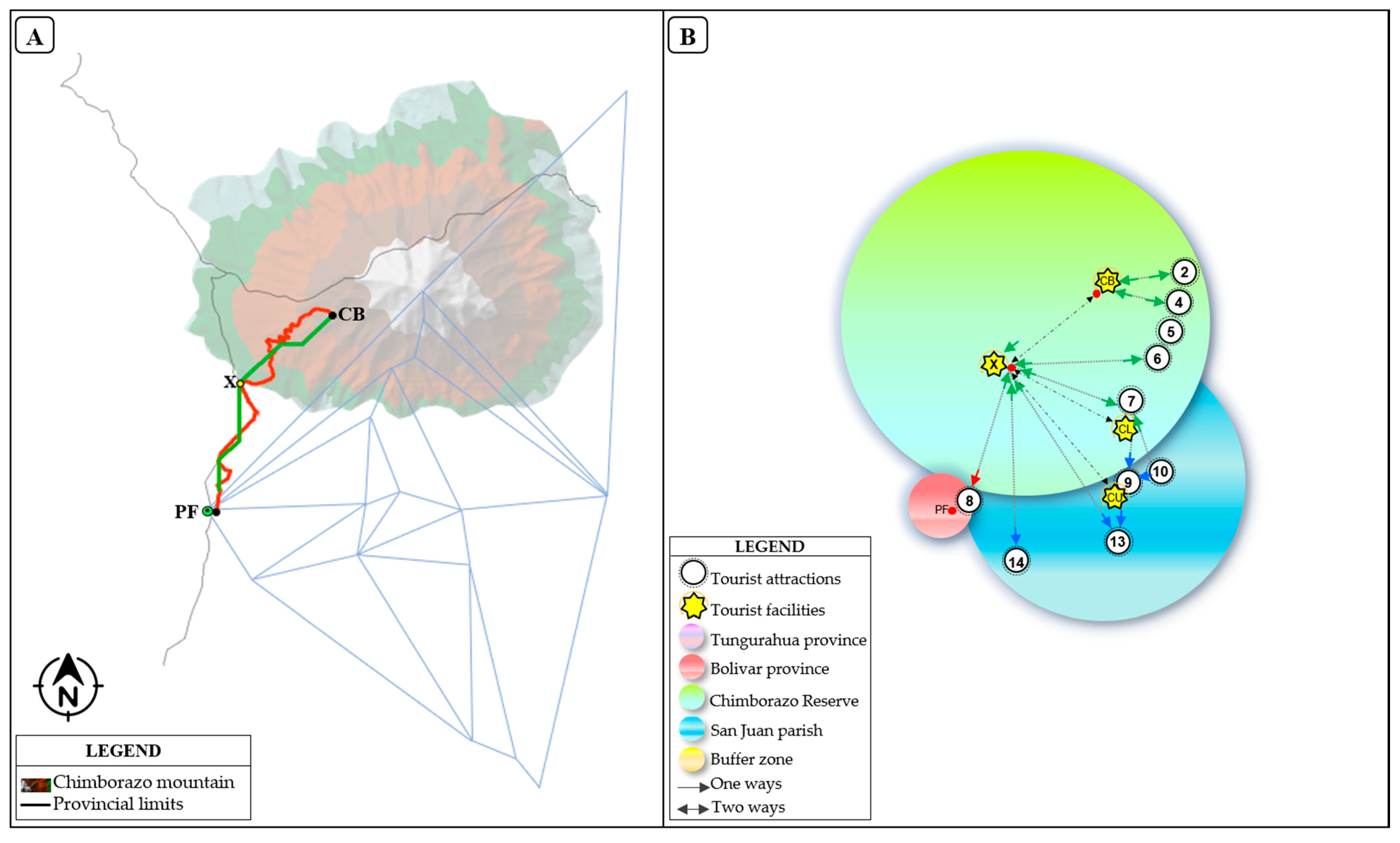
2.1. Study Area
2.2. Methodoly
2.2.1. Identification of Interest Points and Tourist Facilities
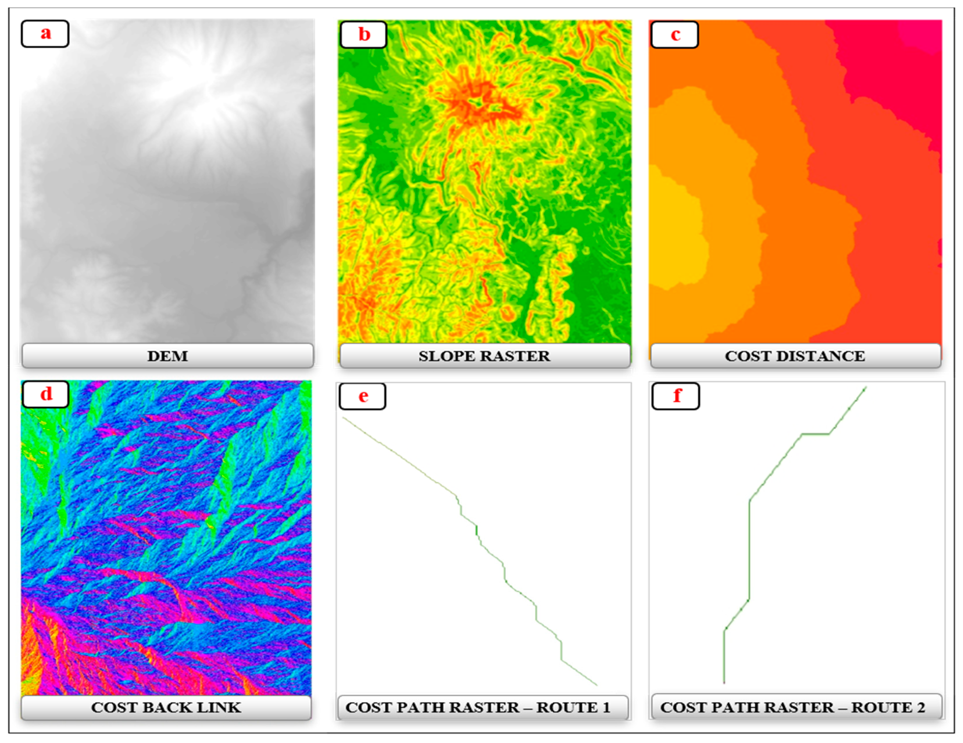
2.2.2. Design of Efficient Routes
- Ci = cost value of the cell i;
- Cj = the cost value of the neighbor cell j.
2.2.3. Creation of the Cost Matrix
3. Results
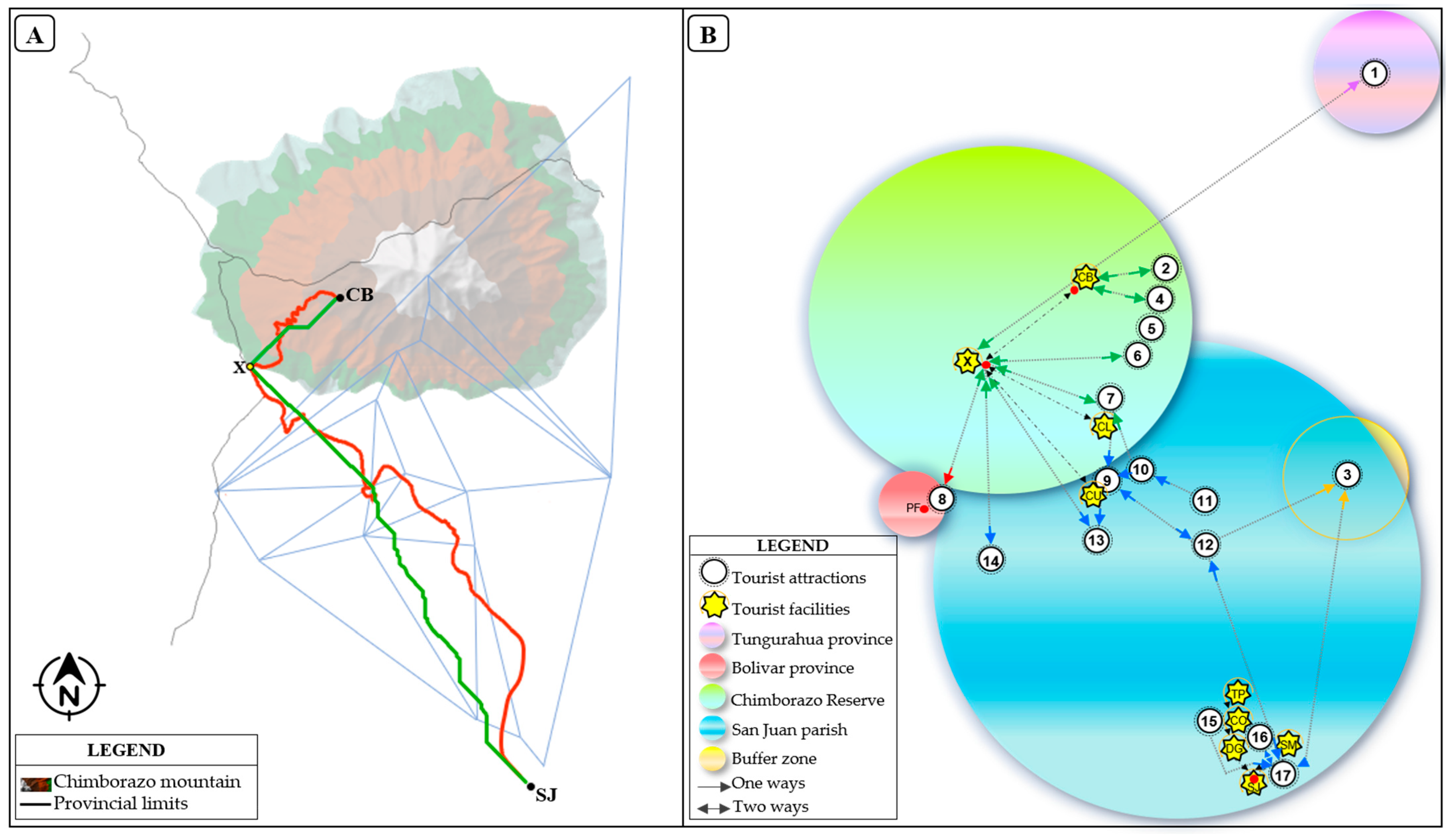
3.1. Network of Tourist Attractions
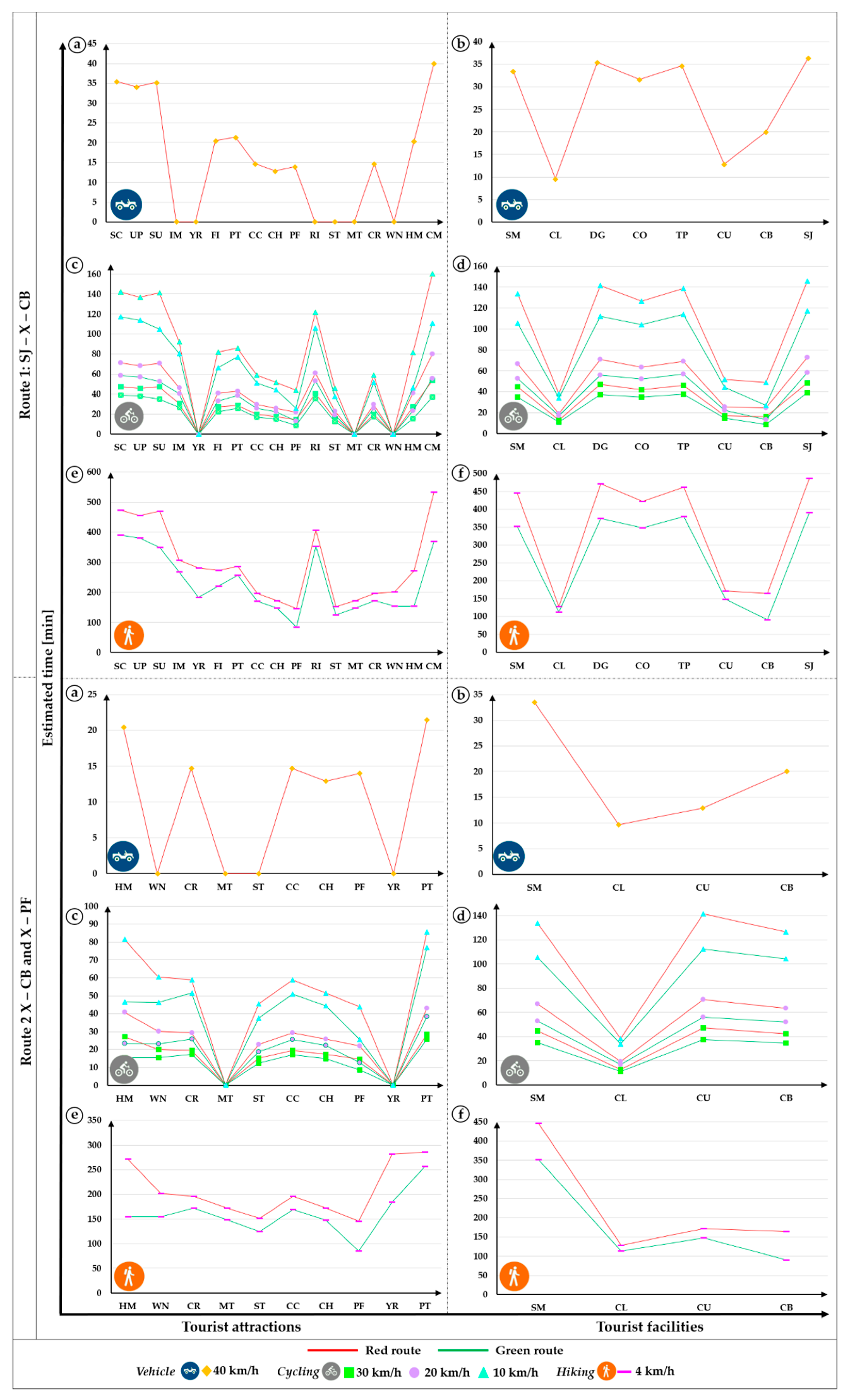
3.2. Mapping of Tourist Routes
3.3. Cost Matrix
4. Discussion
5. Conclusions
Author Contributions
Funding
Institutional Review Board Statement
Informed Consent Statement
Data Availability Statement
Acknowledgments
Conflicts of Interest
References
- World Tourism Organization. World Tourism Barometer and Statistical Annex, March 2021. UNWTO World Tour. Barom 2021, 19, 1–32. [Google Scholar]
- Lopes, P.; Almeida, L.; Pinto, J.; De Jesus, J.; Fernandes, D.; Vieira, I.; Gama, R. Open Tourist Information System: A platform for touristic information management and outreach. Inf. Technol. Tour. 2019, 21, 577–593. [Google Scholar] [CrossRef]
- Kordha, E.; Gorica, K.; Sevrani, K. The Importance of Digitalization for Sustainable Cultural Heritage Sites in Albania. In Cultural Sustainable Tourism; Springer: Berlin/Heidelberg, Germany, 2019; pp. 91–97. [Google Scholar] [CrossRef]
- Guttentag, D. Virtual reality: Applications and implications for tourism. Tour. Manag. 2010, 31, 637–651. [Google Scholar] [CrossRef]
- Tussyadiah, I.; Fesenmaier, D. Marketing places through first-person stories—An analysis of Pennsylvania roadtripper blog. J. Travel Tour. Mark. 2008, 25, 299–311. [Google Scholar] [CrossRef]
- Tan, E.; Bakar, B. Ethnic Reunions in Tourism: The Route to Roots. In Asian Cultures and Contemporary Tourism; Springer: Berlin/Heidelberg, Germany, 2018; pp. 21–39. [Google Scholar] [CrossRef]
- Agapito, D.; Mendes, J.; Valle, P. Exploring the conceptualization of the sensory dimension of tourist experiences. J. Destin. Mark. Manag. 2013, 2, 62–73. [Google Scholar] [CrossRef]
- Pedrana, M. Location-based services and tourism: Possible implications for destination. Curr. Issues Tour. 2014, 17, 753–762. [Google Scholar] [CrossRef]
- Zyryanov, A.; Myshlyavtseva, S. Tourist clusters and dominants (a case study of Perm krai). Reg. Res. Russ. 2012, 2, 194–199. [Google Scholar] [CrossRef]
- Park, S.; Huang, Y. Motivators and inhibitors in booking a hotel via smartphones. Int. J. Contemp. Hosp. Manag. 2017, 29, 161–178. [Google Scholar] [CrossRef]
- Rivera, M.; Croes, R.; Zhong, Y. Developing mobile services. Int. J. Contemp. Hosp. Manag. 2016, 28, 2721–2747. [Google Scholar] [CrossRef]
- Lau, G.; McKercher, B. Understanding tourist movement patterns in a destination: A GIS approach. Tour. Hosp. Res. 2006, 7, 39–49. [Google Scholar] [CrossRef]
- Neuhofer, B.; Buhalis, D.; Ladkin, A. A typology of technology-enhanced tourism experiences. Int. J. Tour.Res. 2014, 16, 340–350. [Google Scholar] [CrossRef]
- Michelsen, G.; Fischer, D. Sustainability and education. In Sustainable Development Policy: A European Perspective; Taylor and Francis: Abingdon, UK, 2017; pp. 135–158. [Google Scholar]
- Tung, V.; Ritchie, J. Exploring the essence of memorable tourism experiences. Ann. Tour. Res. 2011, 38, 1367–1386. [Google Scholar] [CrossRef]
- Shcherbina, O.; Shembeleva, E. Modeling recreational systems using optimization techniques and information technologies. Ann. Oper. Res. 2014, 221, 309–329. [Google Scholar] [CrossRef]
- Xiao, H.; Bi, W. Intra-attraction tourist spatial-temporal behaviour patterns. Tour. Geogr. 2012, 14, 625–645. [Google Scholar] [CrossRef]
- Hoy, A.; Hänsel, S.; Matschullat, J. How can winter tourism adapt to climate change in Saxony’s mountains? Reg. Environ. Chang. 2011, 11, 459–469. [Google Scholar] [CrossRef]
- Du, J.; Zhou, J.; Li, X.; Li, L.; Guo, A. Integrated self-driving travel scheme planning. Int. J. Prod. Econ. 2020, 232, 107963. [Google Scholar] [CrossRef]
- Uwaisy, M.; Baizal, Z.; Reditya, M. Recommendation of Scheduling Tourism Routes using Tabu Search Method (Case Study Bandung). Procedia Comput. Sci. 2019, 157, 150–159. [Google Scholar] [CrossRef]
- Lim, K.; Chan, J.; Karunasekera, S.; Leckie, C. Tour recommendation and trip planning using location-based social media: A survey. Knowl. Inf. Syst. 2019, 60, 1247–1275. [Google Scholar] [CrossRef]
- Anagnostopoulos, A.; Atassi, R.; Becchetti, L.; Fazzone, A.; Silvestri, F. Tour recommendation for groups. Data Min. Knowl. Discov. 2016, 31, 1157–1188. [Google Scholar] [CrossRef]
- Wörndl, W.; Hefele, A.; Herzog, D. Recommending a sequence of interesting places for tourist trips. Inf. Technol. Tour. 2017, 17, 31–54. [Google Scholar] [CrossRef]
- Díez, M.; Babri, S. Explanatory variables underlying the route choice decisions of tourists: The case of Geiranger Fjord in Norway. Transp. Res. Part A Policy Pract. 2020, 141, 398–409. [Google Scholar] [CrossRef]
- Gavalas, D.; Konstantopoulos, C.; Mastakas, K.; Pantziou, G. A survey on algorithmic approaches for solving tourist trip design problems. J. Heuristics 2014, 20, 291–328. [Google Scholar] [CrossRef]
- Chen, H.; Chen, P.; Okumus, F. The relationship between travel constraints and destination image: A case study of Brunei. Tour. Manag. 2013, 35, 198–208. [Google Scholar] [CrossRef]
- Bagloee, S.; Tavana, M.; Di Caprio, D.; Asadi, M.; Heshmati, M. A multi-user decision support system for online city bus tour planning. J. Mod. Transp. 2017, 25, 59–73. [Google Scholar] [CrossRef] [Green Version]
- Schmallegger, D.; Carson, D. Blogs in tourism: Changing approaches to information exchange. J. Vacat. Mark. 2008, 14, 99–110. [Google Scholar] [CrossRef]
- Ahmedi, L.; Rrmoku, K.; Sylejmani, K.; Shabani, D. A bimodal social network analysis to recommend points of interest to tourists. Soci. Netw. Anal. Min. 2017, 7, 14. [Google Scholar] [CrossRef]
- Yun, H.; Park, M. Time–space movement of festival visitors in rural areas using a smart phone application. Asia Pac. J. Tour. Res. 2015, 20, 1246–1265. [Google Scholar] [CrossRef]
- Green, N. On the move: Technology, mobility, and the mediation of social time and space. Inf. Soc. 2002, 18, 281–292. [Google Scholar] [CrossRef] [Green Version]
- Puchongkawarin, C.; Ransikarbum, K. An Integrative Decision Support System for Improving Tourism Logistics and Public Transportation in Thailand. Tour. Plan. Dev. 2020, 1–16. [Google Scholar] [CrossRef]
- Alivand, M.; Hochmair, H.; Srinivasan, S. Analyzing how travelers choose scenic routes using route choice models. Comput. Environ. Urban Syst. 2015, 50, 41–52. [Google Scholar] [CrossRef]
- Stathopoulos, E.; Kokkalas, A.; Mitsopoulou, E.; Patenidis, A.; Meditskos, G.; Diplaris, S.; Kompatsiaris, I. Knowledge-Based Management and Reasoning on Cultural and Natural Touristic Routes. In Proceedings of the IFIP International Conference on Artificial Intelligence Applications and Innovations, Neos Marmaras, Greece, 5–7 June 2020; pp. 355–367. [Google Scholar] [CrossRef]
- Buhalis, D.; Law, R. Progress in information technology and tourism management: 20 years on and 10 years after the Internet—The state of eTourism research. Tour. Manag. 2008, 29, 609–623. [Google Scholar] [CrossRef] [Green Version]
- Edwards, D.; Griffin, T. Understanding tourists’ spatial behaviour: GPS tracking as an aid to sustainable destination management. J. Sustain. Tour. 2013, 21, 580–595. [Google Scholar] [CrossRef]
- James Madison University. What Is GIS? 2020. Available online: https://www.jmu.edu/facmgt/gis/index.shtml (accessed on 1 December 2020).
- Gu, Q.; Zhang, H.; Huang, S.; Zheng, F.; Chen, C. Tourists’ spatiotemporal behaviors in an emerging wine region: A time-geography perspective. J. Destin. Mark. Manag. 2021, 19, 100513. [Google Scholar] [CrossRef]
- Suzuki, D.; Takagi, H. Evaluation of geosite for sustainable planning and management in geotourism. Geoheritage. 2018, 10, 123–135. [Google Scholar] [CrossRef]
- Kabak, M.; Erbaş, M.; Çetinkaya, C.; Özceylan, E. A GIS-based MCDM approach for the evaluation of bike-share stations. J. Clean. Prod. 2018, 201, 49–60. [Google Scholar] [CrossRef]
- Gong, H.; Chen, C.; Bialostozky, E.; Lawson, C. A GPS/GIS method for travel mode detection in New York City. Comput. Environ. Urban Syst. 2012, 36, 131–139. [Google Scholar] [CrossRef]
- Zhang, X.; Yang, Y.; Zhang, Y.; Zhang, Z. Designing tourist experiences amidst air pollution: A spatial analytical approach using social media. Ann. Tour. Res. 2020, 84, 102999. [Google Scholar] [CrossRef]
- Zhang, J.; Kawasaki, H.; Kawai, Y. A tourist route search system based on web information and the visibility of scenic sights. In Proceedings of the 2008 Second International Symposium on Universal Communication, Osaka, Japan, 15–16 December 2008; pp. 154–161. [Google Scholar] [CrossRef]
- Istomina, E.; Luzhkova, N. Birdwatching tourism infrastructure planning in the Ria Formosa natural park (Portugal). Geogr. Nat. Resour. 2016, 37, 371–378. [Google Scholar] [CrossRef]
- Chancellor, C.; Cole, S. Using geographic information system to visualize travel patterns and market research data. J. Travel Tour. Mark. 2008, 25, 341–354. [Google Scholar] [CrossRef]
- Timothy, D.; Boyd, S. Tourism and Trails: Cultural, Ecological and Management Issues; Channel View Publications: Bristol, UK, 2015. [Google Scholar]
- Cooper, C. Spatial and temporal patterns of tourist behaviour. Reg. Stud. 1981, 15, 359–371. [Google Scholar] [CrossRef]
- Cardonha, C.; Herrmann, R.; Avegliano, P. Theoretical Aspects of the Integrated Route Planning Problem. IFAC Proc. Vol. 2013, 46, 427–432. [Google Scholar] [CrossRef]
- Angskun, J.; Korbua, S.; Angskun, T. Time-related factors influencing on an itinerary planning system. J. Hosp. Tour. Technol. 2016, 7, 16–36. [Google Scholar] [CrossRef]
- Boccia, F.; Di Gennaro, R.; Sarnacchiaro, P.; Sarno, V. Tourism satisfaction and perspectives: An exploratory study in Italy. Qual. Quant. 2019, 1–12. [Google Scholar] [CrossRef]
- Meng, B.; Choi, K. Tourists’ intention to use location-based services (LBS): Converging the theory of planned behavior (TPB) and the elaboration likelihood model (ELM). Int. J. Contemp. Hosp. Manag. 2019, 31, 3097–3115. [Google Scholar] [CrossRef]
- Zheng, W.; Liao, Z.; Qin, J. Using a four-step heuristic algorithm to design personalized day tour route within a tourist attraction. Tour. Manag. 2017, 62, 335–349. [Google Scholar] [CrossRef]
- Mutana, S.; Mukwada, G. Mountain-route tourism and sustainability. A discourse analysis of literature and possible future research. J. Outdoor Recreat. Tour. 2018, 24, 59–65. [Google Scholar] [CrossRef]
- Castillo, D.; Gavilanes, A.; Ricaurte, C.; Chávez, C.; Marcu, V.; Borz, S. Perception and use of cultural ecosystem services among the Andean communities of Chimborazo reserve. Environ. Eng. Manag. J. 2019, 18, 1–14. [Google Scholar]
- Castillo, D. Evaluation of the Capacity of Polylepis Forest to Provide Cultural Ecosystem Services and Income for its Conservation Measures in the Framework of Chimborazo Natural Reserve’s Landscape. Ph.D. Thesis, Universitatea Transilvania Brasov, Brașov, Romania, 2020. [Google Scholar]
- Castillo, D.; Chávez, C.; Marcu, V.; Gavilanes, A. The use of cultural ecosystem services: A comparison between locals and tourists in the Chimborazo Natural Reserve. Bull. Transilv.Univ. Braş. Ser. II For. Wood Ind. Agric. Food Eng. 2020, 13, 1–18. [Google Scholar] [CrossRef]
- Ministerio del Ambiente del Ecuador (MAE). Plan de Manejo de Visitantes de la Reserva de Producción de Fauna Chimborazo, Riobamba Ecuador; Final Report; Ministerio del Ambiente del Ecuador: Quito, Ecuador, 2017. [Google Scholar]
- Kádár, B.; Gede, M. Tourism flows in large-scale destination systems. Ann. Tour. Res. 2021, 87, 103113. [Google Scholar] [CrossRef]
- Pearce, P. Tourists’ perception of time: Directions for design. Ann. Tour. Res. 2020, 83, 102932. [Google Scholar] [CrossRef]
- Mestanza-Ramón, C.; Henkanaththegedara, S.M.; Vásconez Duchicela, P.; Vargas Tierras, Y.; Sánchez Capa, M.; Constante Mejía, D.; Jimenez Gutierrez, M.; Charco Guamán, M.; Mestanza Ramón, P. In-Situ and Ex-Situ Biodiversity Conservation in Ecuador: A Review of Policies, Actions and Challenges. Diversity 2020, 12, 315. [Google Scholar] [CrossRef]
- Longás, H. Comparación de Altura del Chimborazo y el Everest (Comparison of Height of Chimborazo and Everest). 2016. Available online: https://elpais.com/elpais/2016/04/06/media/1459968136_940253.html?rel=mas (accessed on 1 December 2020).
- Gobierno Autónomo Descentralizado Parroquial de San Juan. Plan de Desarrollo y Ordenamiento Territorial de la Parroquia de San Juan. 2015. Available online: http://app.sni.gob.ec/sni-link/sni/PORTAL_SNI/data_sigad_plus/sigadplusdocumentofinal/0660823500001_ACTUALIZACIÒNPDYOTSANJUAN2015-2019_30-10-2015_22-28-53.pdf (accessed on 1 December 2020).
- Ministerio del Ambiente del Ecuador (MAE). Environmental Ministry of Ecuador, Update of the Management Plan for the Chimborazo Wildlife Production Reserve; Final Report; Ministerio del Ambiente del Ecuador: Quito, Ecuador, 2014. [Google Scholar]
- Becker, D.; Herrero, D.; Willmes, C.; Weniger, G.; Bareth, G. Investigating the influence of different DEMs on GIS-based cost distance modeling for site catchment analysis of prehistoric sites in Andalusia. ISPRS Int. J. Geo Inf. 2017, 6, 36. [Google Scholar] [CrossRef] [Green Version]
- Chang, K. Introduction to Geographic Information Systems; McGraw-Hill Boston: Boston, MA, USA, 2008. [Google Scholar]
- Dixon, B.; Uddameri, V. GIS and Geocomputation for Water Resource Science and Engineering; John Wiley & Sons: Hoboken, NJ, USA, 2016. [Google Scholar]
- Google Maps. Coordenadas Atractivos Turísticos, Centros de Salud y Planta Turística. 2020. Available online: https://www.google.com.ec/maps (accessed on 1 December 2020).
- Sistema Nacional de Información (SNI). Shapefile de Cobertura Vegetal y de Localización de Centros de Salud. 2014. Available online: https://sni.gob.ec/coberturas (accessed on 1 December 2020).
- Instituto Geográfico Militar (IGM). DEM 30_Set 1: Modelo Digital del Terreno (150817_MDT), Vialidad y Ecuador Volcanoes: Shapefile and SavGIS Vector Format. 2018. Available online: http://www.savgis.org/ecuador.htm (accessed on 1 December 2020).
- Ismail, M.; Mohamed, K. Interactive 3D Image of Ayer Hitam Forest Reserve from Triangular Irregular Network (TIN) layers by Draping Technique. Buletin Geospatial Sektor Awam. 2008, 1–9. [Google Scholar]
- Lucid Software. Lucidchart. 2020. Available online: https://www.lucidchart.com/ (accessed on 1 December 2020).
- Azcarate, G. La Nueva Ciencia del Movimiento de Galileo: Una Génesis Difícil. Enseñanza de las Ciencias: Revista de Investigación y Experiencias Didácticas. pp. 203–208. Available online: https://www.raco.cat/index.php/Ensenanza/article/download/56995/92701 (accessed on 15 January 2021).
- Díaz, S.; González, L. Reflexiones sobre los conceptos velocidad y rapidez de una partícula en física. Rev. Mex. Fís. E 2010, 56, 181–189. [Google Scholar]
- Gobierno Autónomo Descentralizado Provincial de Chimborazo. Datos Turísticos; Final Report; Gobierno Autónomo Descentralizado Provincial de Chimborazo: Riobamba, Ecuador, 2020. [Google Scholar]
- Burgos, M.; Castillo, M.; Beltrán, P.; Giacomone, B.; Godino, J. Análisis didáctico de una lección sobre proporcionalidad en un libro de texto de primaria con herramientas del enfoque ontosemiótico. Bolema Bol. Educ. Matemát. 2020, 34, 40–68. [Google Scholar] [CrossRef] [Green Version]
- Martín, J.; Palacio, A.B. El proceso de formación de la imagen de los destinos turísticos: Una revisión teórica. Estudios Turísticos 2002, 154, 5–32. [Google Scholar]
- Abellán, F.; González, J. Propuesta metodológica para la identificación, clasificación y puesta en valor de los recursos territoriales del turismo interior. La provincia de Albacete. Bol. Asoc. Geógrafos Esp. 2010, 54, 361–383. [Google Scholar]
- Connell, J.; Page, S. Exploring the spatial patterns of car-based tourist travel in Loch Lomond and Trossachs National Park, Scotland. Tour. Manag. 2008, 29, 561–580. [Google Scholar] [CrossRef] [Green Version]
- Lomond, L. The Trossachs National Park Authority. National Park Plan Consultative Draft; LNPA: Balloch, UK, 2005. [Google Scholar]
- Hall, C.; Page, S. The geography of tourism and recreation: Environment, Place and Space; Routledge: Abingdon, UK, 2014. [Google Scholar]
- Dickinson, J.; Calver, S.; Watters, K.; Wilkes, K. Journeys to heritage attractions in the UK: A case study of National Trust property visitors in the south west. J. Transp. Geogr. 2004, 12, 103–113. [Google Scholar] [CrossRef]
- Eaton, B.; Holding, D. The evaluation of public transport alternatives to the car in British National Parks. J. Transp.Geogr. 1996, 4, 55–65. [Google Scholar] [CrossRef]
- Pirselimoğlu, Z.; Demirel, Ö. Ecology-based tourism potential with regard to alternative tourism activities in Altındere Valley (Trabzon–Maçka). Int. J. Sustain. Dev. World Ecol. 2015, 22, 39–49. [Google Scholar] [CrossRef]
- De Vos, J.; Derudder, B.; Van Acker, V.; Witlox, F. Reducing car use: Changing attitudes or relocating? The influence of residential dissonance on travel behavior. J. Transp.Geogr. 2012, 22, 1–9. [Google Scholar] [CrossRef] [Green Version]
- Serra, M. El cicloturismo y las vías verdes como ejemplo de turismo sostenible/Cycle tourism and rail trails as examples of sustainable tourism. Rev. CIDOB d’Afers Int. 2016, 187–209. [Google Scholar] [CrossRef]
- Chen, C.; Chen, P. Estimating recreational cyclists’ preferences for bicycle routes–Evidence from Taiwan. Transp. Policy 2013, 26, 23–30. [Google Scholar] [CrossRef]
- Alivand, M.; Hochmair, H. Choice set generation for modeling scenic route choice behavior with geographic information systems. Transp. Res. Rec. 2015, 2495, 101–111. [Google Scholar] [CrossRef]
- Hall, C.; Lew, A. Understanding and Managing Tourism Impacts: An Integrated Approach; Routledge: Abingdon, UK, 2009. [Google Scholar]
- Düzgüneş, E.; Demirel, Ö. Determining the tourism potential of the Altındere Valley National Park (Trabzon/Turkey) with respect to its conservation value. Int. J. Sustain. Dev. World Ecol. 2013, 20, 358–368. [Google Scholar] [CrossRef]
- Mestanza-Ramón, C.; Jiménez-Caballero, J.L. Nature Tourism on the Colombian—Ecuadorian Amazonian Border: History, Current Situation, and Challenges. Sustainability 2021, 13, 4432. [Google Scholar] [CrossRef]


| Input Files | Format | Source | Specifications |
|---|---|---|---|
| Digital Elevation Model (DEM) | Digital Elevation Model (*.dem) | Layers of geographic information * | DEM 30_Set 4 (30 Mb), UTM longitude from 864000 to 936000. 30 m Resolution per pixel. |
| Projected Coordinate System: WGS_1984_UTM_Zone_17S | |||
| Projection: Transverse Mercator | |||
| Triangular Irregular Network (TIN)—Chimborazo Mountain | Triangular Irregular Network (*.adf) | Layers of geographic information * | TIN: delaunay conforming |
| Number of Data Nodes: 248474 | |||
| Number of Data Triangles: 492940 | |||
| Z Range: (3967.650391, 6240.000000) | |||
| Projected Coordinate System: WGS_1984_UTM_Zone_17S | |||
| Projection: Transverse Mercator | |||
| UTM coordinates of tourist attractions | Excel spreadsheet (*.xlsx) | Environment Ministry of Ecuador (2017) [57], Castillo et al. (2019) [54], Google maps (2020) [68] | Version 2020 |
| Main road | Shapefile (*.shp) | Layers of geographic information * | Geometry Type: polyline |
| Projected Coordinate System: WGS_1984_UTM_Zone_17S | |||
| Projection: Transverse Mercator | |||
| Health center | Shapefile (*.shp) | National Information System of Ecuador (2014) [69], Google maps (2020) [68] | Geometry Type: point |
| Scale 1:50.000 | |||
| Projected Coordinate System: WGS_1984_UTM_Zone_17S | |||
| Projection: Transverse Mercator | |||
| Tourist facilities | Excel spreadsheet (*.xlsx) | Document from the review in Google maps (2020) [68] | Version 2020 |
| No. | Interest Points | Short Description | Code | Province of Location | ||
|---|---|---|---|---|---|---|
| Chimborazo | Bolívar | Tungurahua | ||||
| Tourist attractions | ||||||
| 1 | Carihuairazo Mountain | Three peaked volcano: It is a mountain glacier with an extension of rock to the top that is over 5020 m.a.s.l. It is allowed to go trekking, climbing and hiking activities. | CM | x | ||
| 2 | Chimborazo Mountain | Highest mountain/volcano in Ecuador: Highest mountain/volcano in Ecuador with 6268 m.a.s.l, known as the closest point to the sun. The main activities that can be carried out are: high mountains, observation of flora and fauna, trekking, photography, camping and research. | HM | x | ||
| 3 | Route of the Ice Makers | Route of the ice makers: It is a millenary route by which the locals travel until they reach the ice mines. | RI | x | ||
| 4 | Whympers’s Needles | It is a rock formation, it is named after Edward Whymper, the first conqueror of Chimborazo mountain. | WN | x | ||
| 5 | Chimborazo Wildlife Reserve | Protected area: It is a Protected area of Ecuador, it represents one of the most important tourist attractions of the Province and the Ecuador, such as the Chimborazo mountain. | CR | x | ||
| 6 | Machay Temple | Sacred cave of volcanic material: Sacred cave of volcanic material, where the ancient indigenous people of the area used it as a ceremonial and veneration center for the Chimborazo mountain. | MT | x | ||
| 7 | Solitary Tree | Tree with ancestral values: It is a kind of large bush 5 m high and 6 m in diameter, which is located in the middle of the moor, surrounded by mounds of sand called dunes located on the slopes of Chimborazo mountain. | ST | x | ||
| 8 | Polylepis Forest | Polylepis relict forest: It is a remnant of Polylepis forest, surrounded by a rock formation, represent a viewpoint to Chimborazo mountain. | PF | x | x | |
| 9 | Condor House | Community tourism center: Natural site where there are branches of forest, grasslands, pads, chuquiragua, among others. In this place there is a waterfall of about 30 m approximately. | CH | x | ||
| 10 | Chorrera Canyon | Rocky formation: It is a rock formation in which a fall of crystalline waters of approximately 25 m high descends. The site presents rock formations that form an ideal wall for those who like climbing. | CC | x | ||
| 11 | Fortress of the Incas | Archeological site: Ceremonial center, where it was considered that the Incas performed their rituals. | FI | x | ||
| 12 | Ice Mines | Fossil ice mine: It represents the fossilized ice mine that is under 30 cm from the ground surface. | IM | x | ||
| 13 | Yana Rumi | Black stone: Rock formation and ceremonial site for the locals. | YR | x | ||
| 14 | Pogyo Tayta Andrés | Water spring: Formerly it was a healing center, people bathed in this place to cure their illnesses. Sacred rituals are performed thanking Pacha Mama for her kindness. | PT | x | ||
| 15 | Shobol Urcu vantage point | Natural viewpoint: It is a mountain, constituted as a natural viewpoint, where you can see the Chimborazo mountain. | SU | x | ||
| 16 | Union of Peasant Organizations of San Juan | Community tourism organization: Community tourism organization that offer tourist activities. | UP | x | ||
| 17 | San Juan Bautista Church | Principal church: Main church of the San Juan parish. Locals venerate the image of San Juan Bautista. | SC | x | ||
| Tourist facilities | ||||||
| 1 | Riobamba—Chimborazo E492 Manifold track | Paved road, main axis | DC | x | x | x |
| 2 | Shobolpamba Medical Dispensary | Health center located in San Juan Parish | SM | x | ||
| 3 | Chimborazo Lodge | Lodging and food services—Private | CL | x | ||
| 4 | Dream Garden Lodge | Lodging and food services—Private | DG | x | ||
| 5 | Chimborazo country house | Lodging services—Private | CO | x | ||
| 6 | Tambo Pak Samay | Lodging and food services—Private | TP | x | ||
| 7 | Condor House Lodge | Lodging and food services—Community | CU | x | ||
| 8 | Tourist Information Center | CR Tourist Information Center | X | x | ||
| 9 | Carrel Brothers Refuge | First refuge of the CR. Lodging and food services—Private | CB | x | ||
| 10 | San Juan parish | Town center and parish head | SJ | x | ||
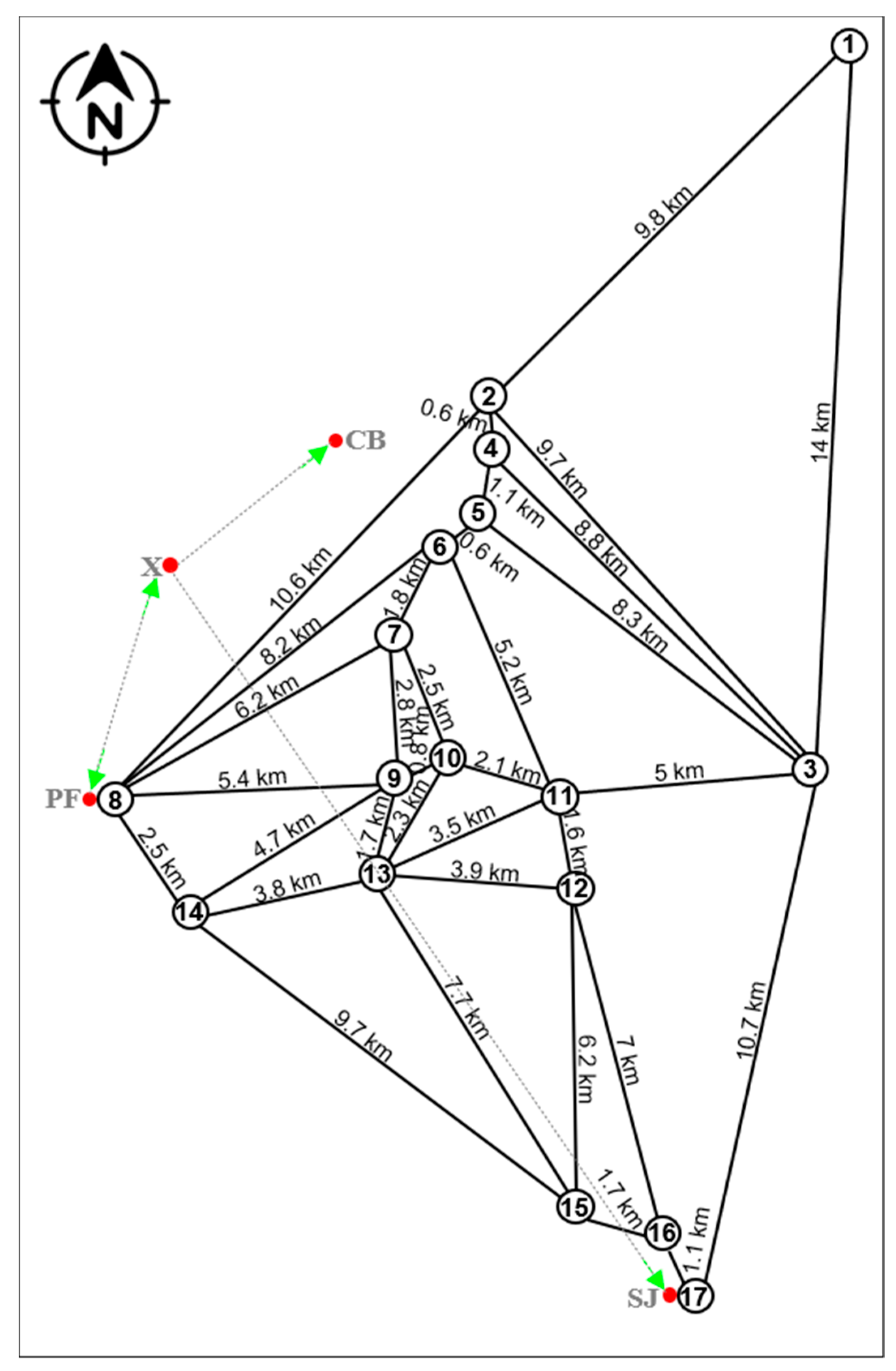
| No. | Code | Approximate Distance of Interest Points in Relation to X (km) in Real Route | Estimated Time of Interest Points in Relation to X (min) | State of the Road ** | ||||||||||
|---|---|---|---|---|---|---|---|---|---|---|---|---|---|---|
| Vehicle | Cycling | Hiking | ||||||||||||
| Professional | Medium | Beginner | ||||||||||||
| 40 km/h * | 30 km/h * | 20 km/h * | 10 km/h * | 4 km/h at Average Pace * | ||||||||||
| Route 1: SJ-X-CB/Distance: 32.5 km (red), 24.0 km (green) | ||||||||||||||
| Tourist Attractions | ||||||||||||||
| Red | Green | Red | Red | Green | Red | Green | Red | Green | Red | Green | Red | Green | ||
| 17 | SC | 23.7 | 19.5 | 36 | 47 | 39 | 71 | 59 | 142 | 117 | 474 | 390 | pr | pr |
| 16 | UP | 22.8 | 19.0 | 34 | 46 | 38 | 68 | 57 | 137 | 114 | 456 | 380 | pr | pr |
| 15 | SU | 23.5 | 17.5 | 35 | 47 | 35 | 71 | 52 | 141 | 105 | 470 | 349 | pr/dr | pr/dr |
| 12 | IM | 15.4 | 13.4 | – | 31 | 27 | 46 | 40 | 92 | 80 | 308 | 268 | pr/dr | dr |
| 13 | YR | 14.1 | 9.2 | – | – | – | – | – | – | – | 282 | 184 | pr/dr | dr |
| 11 | FI | 13.7 | 11.1 | 21 | 27 | 22 | 41 | 33 | 82 | 66 | 274 | 221 | pr/dr | dr |
| 14 | PT | 14.3 | 12.8 | 21 | 29 | 26 | 43 | 39 | 86 | 77 | 286 | 257 | pr/dr | dr |
| 10 | CC | 9.8 | 8.5 | 15 | 20 | 17 | 29 | 26 | 59 | 51 | 196 | 170 | pr | pr |
| 9 | CH | 8.6 | 7.4 | 13 | 17 | 15 | 26 | 22 | 52 | 44 | 172 | 148 | pr | pr |
| 8 | PF | 7.3 | 4.3 | 14 | 15 | 9 | 22 | 13 | 44 | 26 | 146 | 85 | pr/dr | dr |
| 3 | RI | 20.3 | 17.7 | – | 41 | 35 | 61 | 53 | 122 | 106 | 406 | 353 | pr/dr | dr |
| 7 | ST | 7.6 | 6.2 | – | 15 | 12 | 23 | 19 | 46 | 37 | 152 | 125 | pr/dr | dr |
| 6 | MT | 8.6 | 7.4 | – | – | – | – | – | – | – | 172 | 149 | pr/dr | dr |
| 5 | CR | 9.8 | 8.6 | 15 | 20 | 17 | 29 | 26 | 59 | 52 | 196 | 172 | dr | dr |
| 4 | WN | 10.1 | 7.7 | – | – | – | – | – | – | – | 202 | 154 | dr | dr |
| 2 | HM | 13.6 | 7.8 | 20 | 27 | 16 | 41 | 23 | 82 | 47 | 272 | 155 | dr | dr |
| 1 | CM | 26.7 | 18.5 | 40 | 53 | 37 | 80 | 55 | 160 | 111 | 534 | 370 | dr | dr |
| Tourist Facilities | ||||||||||||||
| 2 | SM | 22.3 | 17.6 | 33 | 45 | 35 | 67 | 53 | 134 | 106 | 446 | 352 | pr | pr |
| 3 | CL | 6.4 | 5.7 | 10 | 13 | 11 | 19 | 17 | 38 | 34 | 128 | 113 | pr/dr | dr |
| 4 | DG | 23.6 | 18.7 | 35 | 47 | 37 | 71 | 56 | 142 | 112 | 472 | 374 | pr | pr |
| 5 | CO | 21.1 | 17.4 | 32 | 42 | 35 | 63 | 52 | 127 | 104 | 422 | 348 | pr/dr | dr |
| 6 | TP | 23.1 | 19.0 | 35 | 46 | 38 | 69 | 57 | 139 | 114 | 462 | 380 | pr | pr |
| 7 | CU | 8.6 | 7.4 | 13 | 17 | 15 | 26 | 22 | 52 | 44 | 172 | 148 | pr | pr |
| 9 | CB | 8.2 | 4.5 | 20 | 16 | 9 | 25 | 14 | 49 | 27 | 164 | 90 | dr | dr |
| 10 | SJ | 24.3 | 19.5 | 36 | 49 | 39 | 73 | 59 | 146 | 117 | 486 | 390 | pr | pr |
| No. | Code | Approximate Distance of Interest Points in Relation to X (km) in Real Route | Estimated Time of Interest Points in Relation to X (min) | State of the Road ** | ||||||||||
|---|---|---|---|---|---|---|---|---|---|---|---|---|---|---|
| Vehicle | Cycling | Hiking | ||||||||||||
| Professional | Medium | Beginner | ||||||||||||
| 40 km/h * | 30 km/h * | 20 km/h * | 10 km/h * | 4 km/h at Average Pace * | ||||||||||
| Route 2: X-CB and X-PF/Distance: 15.5 km (red), 8.8 km (green) | ||||||||||||||
| Tourist Attractions | ||||||||||||||
| Red | Green | Red | Red | Green | Red | Green | Red | Green | Red | Green | Red | Green | ||
| 2 | HM | 13.6 | 7.8 | 20 | 27 | 16 | 41 | 23 | 82 | 47 | 272 | 155 | dr | dr |
| 4 | WN | 10.1 | 7.7 | – | 20 | 15 | 30 | 23 | 61 | 46 | 202 | 154 | dr | dr |
| 5 | CR | 9.8 | 8.6 | 15 | 20 | 17 | 29 | 26 | 59 | 52 | 196 | 172 | dr | dr |
| 6 | MT | 8.6 | 7.4 | – | – | – | – | – | – | – | 172 | 149 | pr/dr | dr |
| 7 | ST | 7.6 | 6.2 | – | 15 | 12 | 23 | 19 | 46 | 37 | 152 | 125 | pr/dr | dr |
| 10 | CC | 9.8 | 8.5 | 15 | 20 | 17 | 29 | 26 | 59 | 51 | 196 | 170 | pr | pr |
| 9 | CH | 8.6 | 7.4 | 13 | 17 | 15 | 26 | 22 | 52 | 44 | 172 | 148 | pr | pr |
| 8 | PF | 7.3 | 4.3 | 14 | 15 | 9 | 22 | 13 | 44 | 26 | 146 | 85 | pr/dr | dr |
| 13 | YR | 12.2 | 9.2 | – | – | – | – | – | – | – | 244 | 184 | pr/dr | dr |
| 14 | PT | 14.3 | 12.8 | 21 | 29 | 26 | 43 | 39 | 86 | 77 | 286 | 257 | pr/dr | dr |
| Tourist facilities | ||||||||||||||
| 2 | SM | 22.3 | 17.6 | 33 | 45 | 35 | 67 | 53 | 134 | 106 | 446 | 352 | pr | pr |
| 3 | CL | 6.4 | 5.7 | 10 | 13 | 11 | 19 | 17 | 38 | 34 | 128 | 113 | pr/dr | dr |
| 7 | CU | 8.6 | 7.4 | 13 | 17 | 15 | 26 | 22 | 52 | 44 | 172 | 148 | pr | pr |
| 9 | CB | 8.2 | 4.5 | 20 | 16 | 9 | 25 | 14 | 49 | 27 | 164 | 90 | dr | dr |
| Estimated Travel Time (min) | |||||
|---|---|---|---|---|---|
| Vehicle | Cycling | Hiking | |||
| Professional | Medium | Beginner | |||
| Route 1: SJ-X-CB | |||||
| Red route total | 264 | 434 | 651 | 1303 | 4998 |
| Green route total | – | 344 | 516 | 1033 | 3930 |
| Share of efficiency (%) | – | 23.3 | 23.2 | 23.1 | 23.4 |
| Route 2: X-CB and X-PF | |||||
| Red route total | 98 | 162 | 243 | 487 | 2076 |
| Green route total | – | 127 | 190 | 380 | 1599 |
| Share of efficiency (%) | – | 28.4 | 28.4 | 28.4 | 28.0 |
Publisher’s Note: MDPI stays neutral with regard to jurisdictional claims in published maps and institutional affiliations. |
© 2021 by the authors. Licensee MDPI, Basel, Switzerland. This article is an open access article distributed under the terms and conditions of the Creative Commons Attribution (CC BY) license (https://creativecommons.org/licenses/by/4.0/).
Share and Cite
Castillo-Vizuete, D.; Gavilanes-Montoya, A.; Chávez-Velásquez, C.; Benalcázar-Vergara, P.; Mestanza-Ramón, C. Design of Nature Tourism Route in Chimborazo Wildlife Reserve, Ecuador. Int. J. Environ. Res. Public Health 2021, 18, 5293. https://doi.org/10.3390/ijerph18105293
Castillo-Vizuete D, Gavilanes-Montoya A, Chávez-Velásquez C, Benalcázar-Vergara P, Mestanza-Ramón C. Design of Nature Tourism Route in Chimborazo Wildlife Reserve, Ecuador. International Journal of Environmental Research and Public Health. 2021; 18(10):5293. https://doi.org/10.3390/ijerph18105293
Chicago/Turabian StyleCastillo-Vizuete, Danny, Alex Gavilanes-Montoya, Carlos Chávez-Velásquez, Paúl Benalcázar-Vergara, and Carlos Mestanza-Ramón. 2021. "Design of Nature Tourism Route in Chimborazo Wildlife Reserve, Ecuador" International Journal of Environmental Research and Public Health 18, no. 10: 5293. https://doi.org/10.3390/ijerph18105293