
Effects of Content of Soil Rock Fragments on Soil Erodibility in China

Abstract
:1. Introduction
2. Materials and Methods
2.1. Data
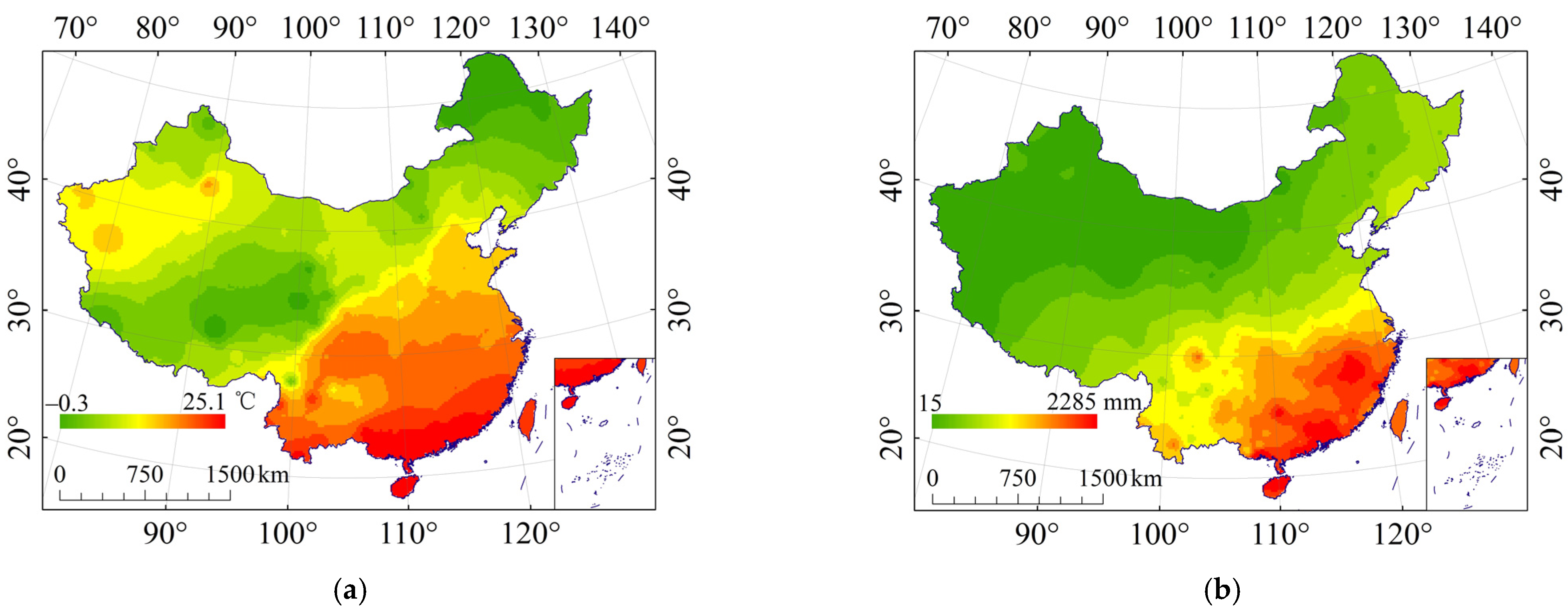
2.1.1. Data Source
2.1.2. Data Pre-Processing
2.2. Methods
2.2.1. Calculation of the Effect of Rock Fragments on K
2.2.2. Sampling Statistics and Typical Sampling Area Analysis
2.2.3. Redundancy Analysis
3. Results
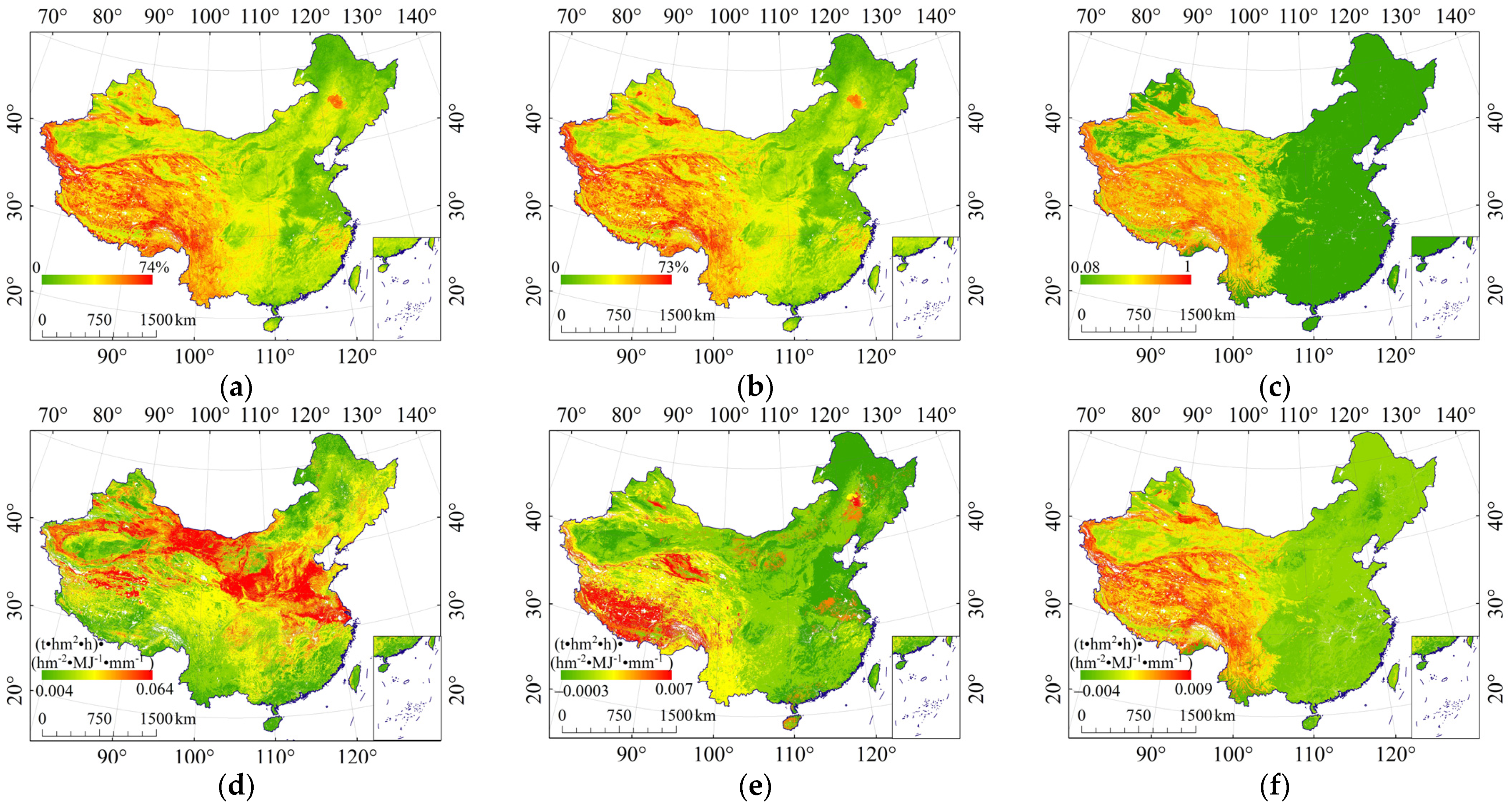
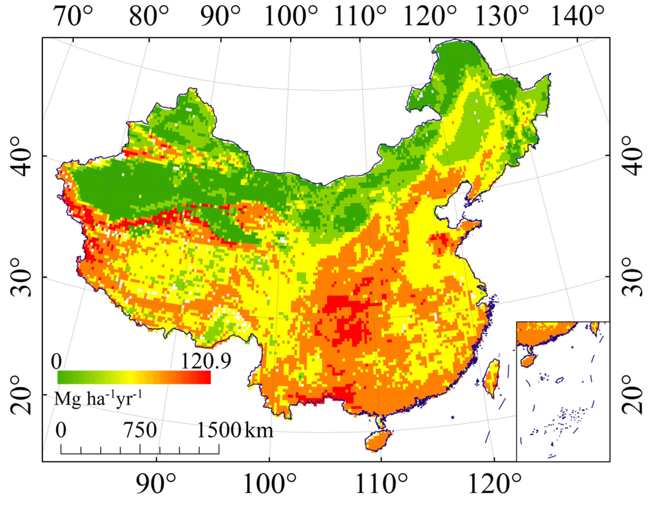
3.1. The Effect of Rock Fragments on K (ER_K)
3.2. Relationship between the Effect of Rock Fragments on K (ER_K) and Topography
3.2.1. Relationship between the Effect of Rock Fragments on K (ER_K) and Terrain Relief
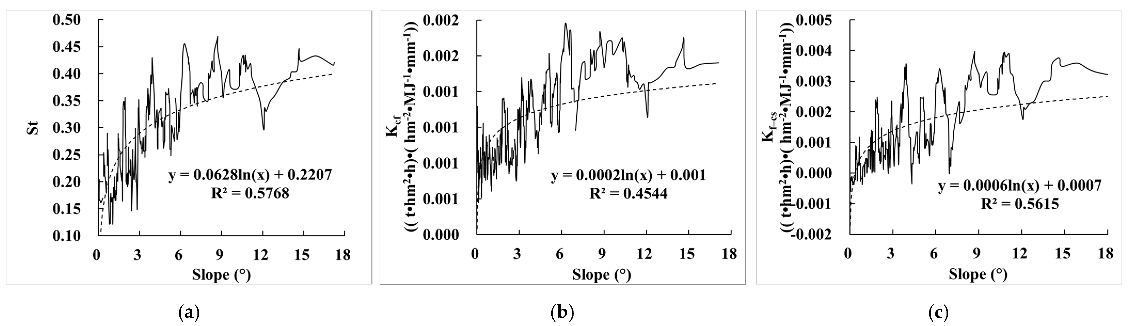
3.2.2. Relationship between the Effect of Rock Fragments on K (ER_K) and Slope
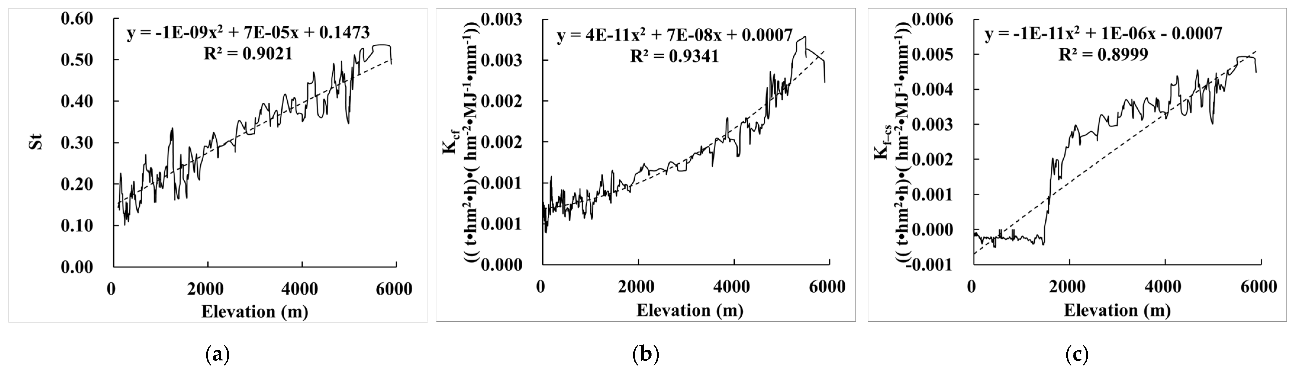
3.2.3. Relationship between the Effect of Rock Fragments on K (ER_K) and Elevation
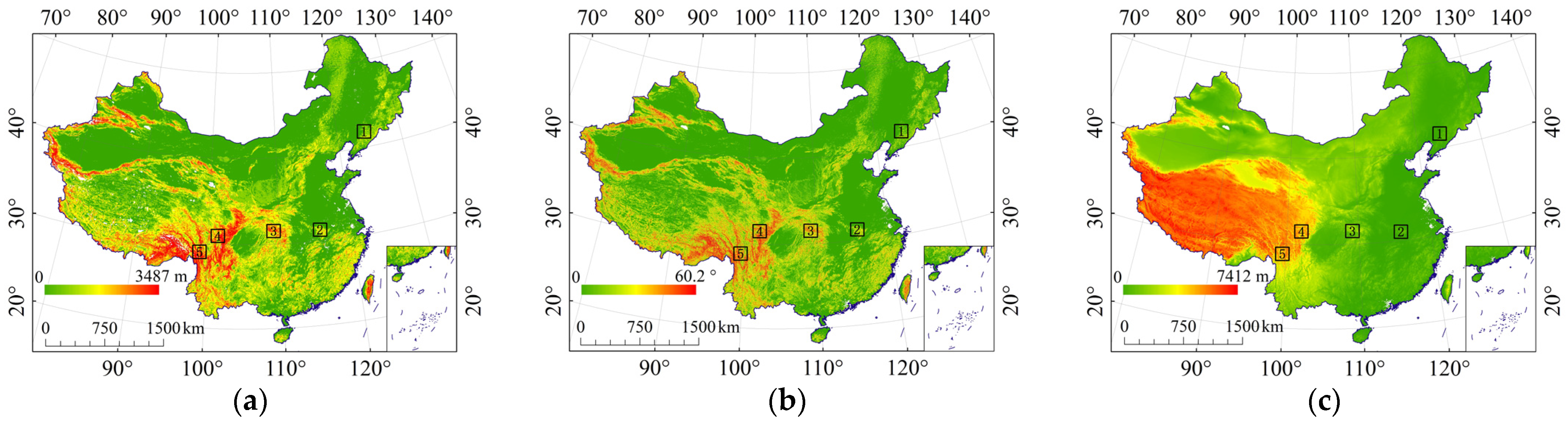
3.2.4. Typical Sampling Areas of Topography
3.3. Relationship between the Effect of Rock Fragments on K (ER_K) and Land Cover
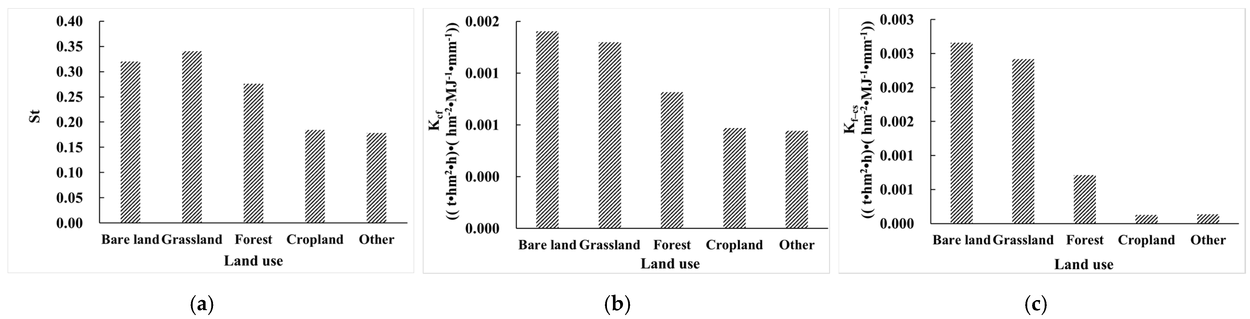
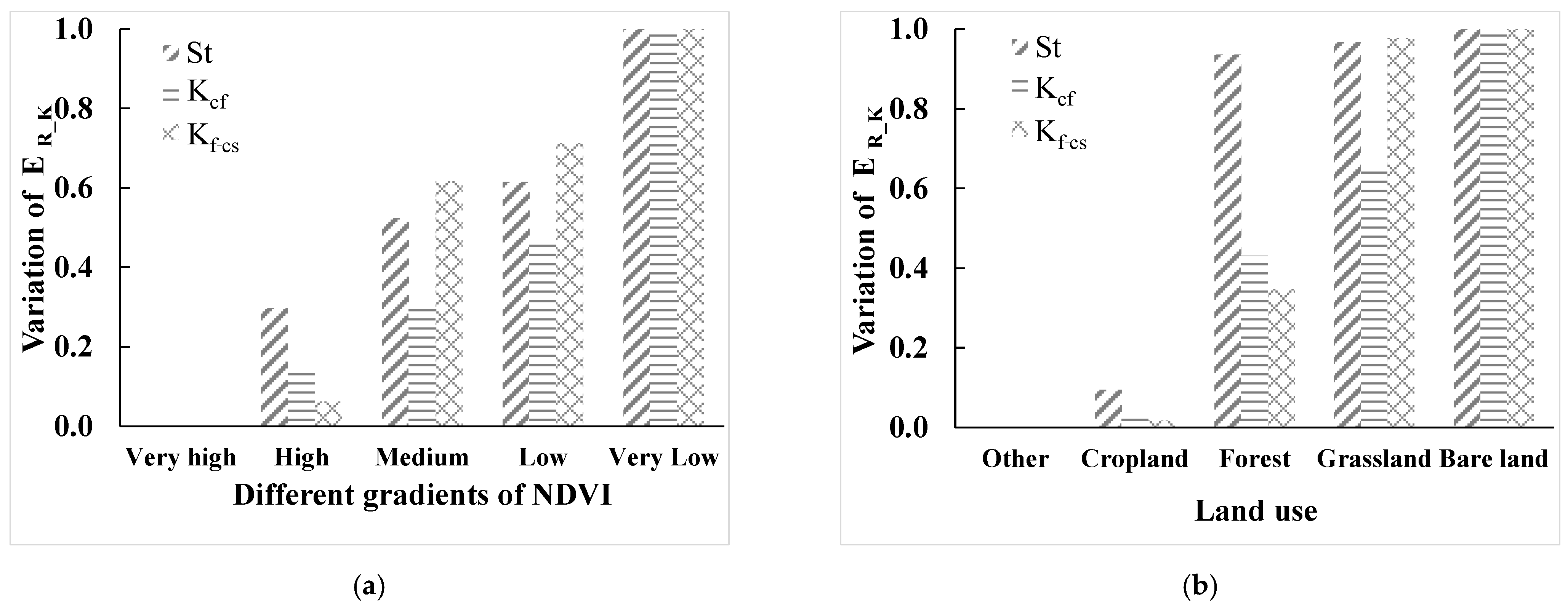
3.3.1. Relationship between the Effect of Rock Fragments on K (ER_K) and Land Use
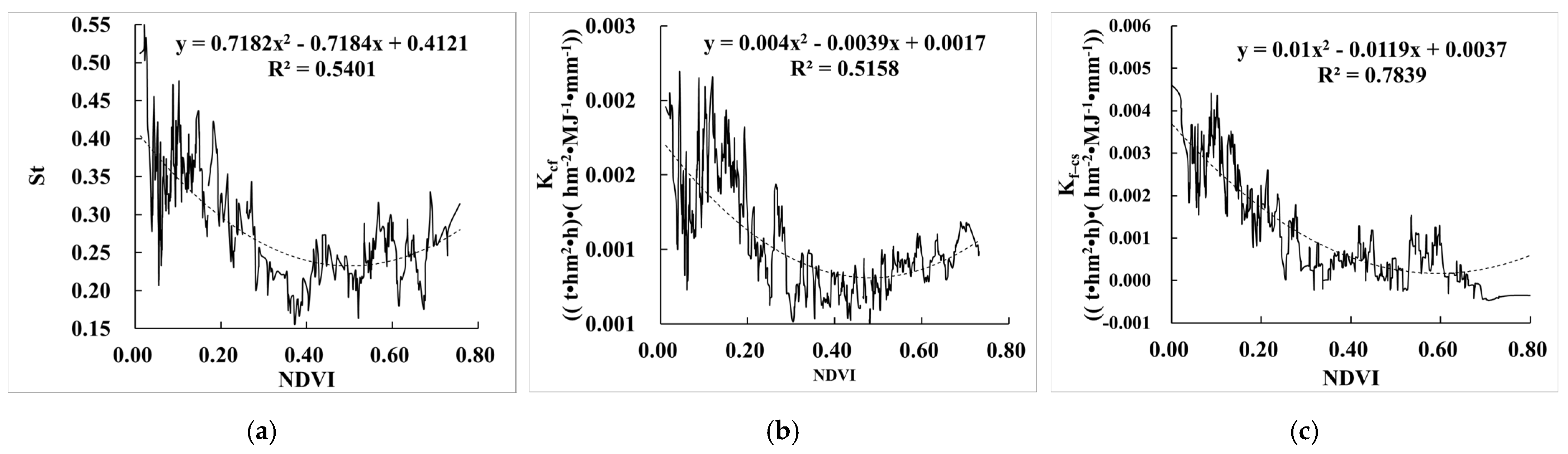
3.3.2. Relationship between the Effect of Rock Fragments on K (ER_K) and NDVI
3.3.3. Typical Sampling Areas of Land Cover
3.4. Relationship between the Effect of Rock Fragments on K (ER_K) and Soil Type
3.5. Relationship between the Effect of Rock Fragments on K (ER_K) and Climate
3.5.1. Relationship between the Effect of Rock Fragments on K (ER_K) and Temperature
3.5.2. Relationship between the Effect of Rock Fragments on K (ER_K) and Precipitation
3.6. Impact of Influencing Factors on the Effect of Rock Fragments on K (ER_K)
4. Discussion
4.1. The Source and Classes of Rock Fragments
4.2. The Influencing Factors of the Effect of Rock Fragment on K
4.3. The Effect of Rock Fragments on Regional Soil Erosion Evaluation
4.4. Implications for Production Practice
5. Conclusions
- (1)
- The rock fragments in the soil profile (RFP) increased soil erodibility (K) by 0.0011 (t·hm2·h)·(hm−2·MJ−1·mm−1), the rock fragments on the surface (RFS) of the soil reduced soil erodibility (K) by 0.0094 (t·hm2·h)·(hm−2·MJ−1·mm−1), and the effect of both RFP and RFS reduced soil erodibility (K) by 0.0013 (t·hm2·h)·(hm−2·MJ−1·mm−1).
- (2)
- This effect of rock fragments had the highest correlation with elevation, followed by terrain relief, vegetation coverage (NDVI), slope, soil type, temperature, and precipitation. The higher the elevation, terrain relief, and slope, the greater the effect of rock fragments on K, and the smaller the precipitation, temperature, and vegetation coverage (NDVI), the less the effect of rock fragments on K. When the soil types were Leptosols, Cryosols, Gypsisols, Solonchaks, Gypsisols, Luvisols, and Calcisols, the influence was greater. The effect of rock fragments on K (ER_K) had little correlation with land use.
- (3)
- The results of RDA analysis showed that the elevation was the main predominant factor affecting ER_K, and the elevation had the greatest influence on St, Kcf, and Kf–cs. The reason is that the topography of China varies greatly, with high elevation mountains and plateaus being widely distributed. These mountainous and plateau areas are usually cold and dry, and the soil erosion is mainly wind erosion. Due to the weak soil-forming process, the content of rock fragments is large, and the effect of rock fragments is also great.
Author Contributions
Funding
Institutional Review Board Statement
Informed Consent Statement
Data Availability Statement
Acknowledgments
Conflicts of Interest
References
- Lal, R. Encyclopedia of Soil Science, 3rd ed.; Applied Soil Ecology: New York, NY, USA, 2016. [Google Scholar]
- Berthelin, J.; Valentin, C.; Munch, J.C. Soils as a Key Component of the Critical Zone 1: Functions and Services; John Wiley & Sons: Hoboken, NJ, USA, 2018. [Google Scholar]
- FAO. Soil Erosion: The Greatest Challenge to Sustainable Soil Management; Food &Agriculture Organization: Rome, Italy, 2019. [Google Scholar]
- FAO. Outcome Document of the Global Symposium on Soil Erosion; Food & Agriculture Organization: Rome, Italy, 2019. [Google Scholar]
- Cheng, D.B.; Cai, C.F.; Zuo, C.Q. Advances in Research of Soil Degradation by Erosion. Res. Soil Water Conserv. 2006, 13, 252. [Google Scholar]
- Wang, Z.L. Analyses of affecting factors of soil erosion and its harms in China. Trans. Chin. Soc. Agric. Eng. 2000, 16, 32–36. [Google Scholar]
- Chen, L. Soil and Water Conservation in China. Soil Water Conserv. China 2002, 7, 4–6. [Google Scholar]
- The Ministry of Water Resources of the People’s Republic of China. Bulletin of 2020 Soil and Water Conservation in China; Ministry of Water Resources: Beijing, China, 2020.
- Römkens, M.J.M.; Young, R.A.; Poesen, J.W.A.; McCool, D.K.; El-Swaify, S.A.; Bradford, J.M. A Guide to conservation planning with the Revised Universal Soil Loss Equation (RUSLE). In Soil Erodibility Factor (K); U.S. Department of Agriculture: Washington, DC, USA, 1997; Volume 703, pp. 65–100. [Google Scholar]
- Liu, B.Y.; Xie, Y.; Li, Z.G.; Liang, Y.; Zhang, W.B.; Fu, S.H.; Yin, S.Q.; Wei, X.; Zhang, K.L.; Wang, Z.Q.; et al. The assessment of soil loss by water erosion in China. Int. Soil Water Conserv. Res. 2020, 8, 430–439. [Google Scholar] [CrossRef]
- Wischmeier, W.H.; Smith, D.D. Predicting Rainfall Erosion Losses, a Guide to Conservation Planning. In Agricultural Handbook; No. 537; U.S. Department of Agriculture: Washington, DC, USA, 1978. [Google Scholar]
- Panagos, P.; Meusburger, K.; Ballabio, C.; Borrelli, P.; Alewell, C. Soil erodibility in Europe: A high-resolution dataset based on LUCAS. Sci. Total Environ. 2014, 479, 189–200. [Google Scholar] [CrossRef]
- Marshall, J.A.; Sklar, L.S. Mining soil databases for landscape-scale patterns in the abundance and size distribution of hillslope rock fragments. Earth Surf. Process. Landf. 2011, 37, 287–300. [Google Scholar] [CrossRef]
- Phillips, J.D.; Luckow, K.; Marion, D.A.; Adams, K.R. Rock fragment distributions and regolith evolution in the Ouachita Mountains, Arkansas, USA. Earth Surf. Process. Landf. 2005, 30, 429–442. [Google Scholar] [CrossRef]
- Poesen, J.; Lavee, H. Rock fragments in top soils:significance and processes. Catena 1994, 23, 1–2. [Google Scholar] [CrossRef]
- Simanton, J.R.; Renard, K.G.; Christiansen, C.M.; Lane, L.J. Spatial distribution of surface rock fragments along catenas in Semiarid Arizona and Nevada, USA. Catena 1994, 23, 29–42. [Google Scholar] [CrossRef]
- Fu, S.H.; Duan, S.H.; Liu, B.Y. The impact of land use on soil texture in Shixia watershed of Miyun County, Beijing. Geogr. Res. 2001, 20, 697–702. [Google Scholar]
- Zhang, X.B.; An, Z.S. Relationship between forests and loess thicknesses in the Loess Plateau region. Bull. Soil Water Conserv. 1994, 1914, 1991–1993. [Google Scholar]
- Pang, L.; Xiao, H.L.; Chai, S.X.; Lu, J.L.; Zhou, M.X.; Chang, L.; Wang, Y.J. Effect of Gravel-Sand Mulching on Soil Microbial Composition. J. Desert Res. 2012, 32, 351–358. [Google Scholar]
- Fu, S.H. Effect of soil containing rock fragment on infiltration. J. Soil Water Conserv. 2005, 19, 171–175. [Google Scholar]
- Zhu, Y.J.; Shao, M.A. Processes of rainfallinfiltration and sediment yield in soils containing different rock fragment contents. Trans. Chin. Soc. Agric. Eng. 2006, 22, 62–67. [Google Scholar]
- Epstein, E.G.; Grant, W.J.; Struchtemeyer, R.A. Effects of Stones on Runoff, Erosion, and Soil Moisture. Soil Sci. Soc. Am. J. 1966, 30, 638–640. [Google Scholar] [CrossRef]
- Jerry, C.; Ritchie, A.; Mark, A.; Nearing, B.; Mary, H.; Nichols, B.; Carole, A.; Ritchie, C. Patterns of Soil Erosion and Redeposition on Lucky Hills Watershed, Walnut Gulch Experimental Watershed, Arizona. Catena. 2005, 61, 122–130. [Google Scholar]
- Jomaa, S.; Barry, D.A.; Heng, B.C.P.; Brovelli, A.; Sander, G.C.; Parlange, J.Y. Influence of rock fragment coverage on soil erosion and hydrological response: Laboratory flume experiments and modeling. Water Resour. Res. 2012, 48, 213–223. [Google Scholar] [CrossRef]
- Ma, C.L.; Dai, C.T.; Liu, Y.J.; Zhou, Y.W. Effects of gravel covering on hydraulic characteristics of slope flow on purple soil. J. Soil Water Conserv. 2019, 33, 150–161. [Google Scholar]
- Poesen, J.; Torri, D.; Bunte, K. Effects of rock fragments on soil erosion by water at different spatial scales a review.pdf. Catena 1994, 23, 141–166. [Google Scholar] [CrossRef]
- Zhou, B.B.; Shao, M.A. Effect of content and size of rock detritus on infiltration. Acta Pedol. Sin. 2007, 44, 801–807. [Google Scholar]
- Li, X.Y. Gravel-sand mulch for soil and water conservation in the semiarid loess region of northwest China. Catena 2003, 52, 105–127. [Google Scholar] [CrossRef]
- Li, X.Y.; Shi, P.J.; Liu, L.Y.; Wang, H.S. Influence of pebble size and cover on rainfall interception by gravel mulch. J. Hydrol. 2005, 312, 70–78. [Google Scholar] [CrossRef]
- Li, Y.; Wang, Z.J.; Wei, F.C.; Gong, J.P. Effect of rock fragment content on water infiltration(diffusion) in purple soils. Acta Pedol. Sin. 2011, 48, 435–439. [Google Scholar]
- Hlaváčiková, H.; Novák, V.; Šimůnek, J. The effects of rock fragment shapes and positions on modeled hydraulic conductivities of stony soils. Geoderma 2016, 281, 39–48. [Google Scholar] [CrossRef] [Green Version]
- Poesen, J.; Lngelmo-Sanchez, E. Runoff and sediment yield from topsoils with different porosity as affected by rock fragment cover and position. Catena 1992, 19, 451–474. [Google Scholar] [CrossRef]
- Li, X.Y.; Contreras, S.; Solé-Benet, A. Spatial distribution of rock fragments in dolines: A case study in a semiarid Mediterranean mountain-range (Sierra de Gádor, SE Spain). Catena 2007, 70, 366–374. [Google Scholar] [CrossRef]
- Li, Y.; Gao, M.; Chao, F.W.; Ji, Z.L. Spatial Distribution of Rock Fragment and Its Influences on Soil Hydrological Processes. Chin. Agric. Sci. Bull. 2006, 22, 271–276. [Google Scholar]
- Nyssen, J.; Poesen, J.; Moeyersons, J.; Lavrysen, E.; Haile, M.; Deckers, J. Spatial distribution of rock fragments in cultivated soils in northern Ethiopia as affected by lateral and vertical displacement processes. Geomorphology 2002, 43, 1–16. [Google Scholar] [CrossRef]
- Zhu, Y.J.; Shao, M.A. Spatial distribution of topsoil gravel in small watershed in the loess plateau. Sci. China Press 2008, 38, 375–383. [Google Scholar]
- Simanton, J.R.; Toy, T.J. The relation between surface rock fragment cover and semiarid hillslope profile morphology. Catena 1994, 23, 213–225. [Google Scholar] [CrossRef]
- Xia, L.; Song, X.; Fu, N.; Cui, S.; Li, L.; Li, H.; Li, Y. Effects of rock fragment cover on hydrological processes under rainfall simulation in a semi-arid region of China. Hydrol. Process. 2018, 32, 792–804. [Google Scholar] [CrossRef]
- Liang, Y.; Liu, X.C.; Cao, L.X.; Zheng, F.L. K value calculation of soil erodibility of China water erosion area and its macro-distribution. Soil Water Conserv. China 2013, 10, 35–40. [Google Scholar]
- Teng, H.F.; Hu, J.; Zhou, Y.; Zhou, L.Q.; Shi, Z. Modelling and mapping soil erosion potential in China. J. Integr. Agric. 2019, 18, 251–264. [Google Scholar] [CrossRef] [Green Version]
- Malvić, T.; Ivšinović, J.; Velić, J.; Sremac, J.; Barudžija, U. Application of the modified shepard’s method (msm): A case study with the interpolation of neogene reservoir variables in northern croatia. Stats 2020, 3, 68–83. [Google Scholar] [CrossRef] [Green Version]
- Ly, S.; Charles, C.; Degré, A. Geostatistical interpolation of daily rainfall at catchment scale: The use of several variogram models in the ourthe and ambleve catchments, Belgium. Hydrol. Earth Syst. Sci. 2011, 15, 2259–2274. [Google Scholar] [CrossRef] [Green Version]
- Teegavarapu, R.; Chandramouli, V. Improved weighting methods, deterministic and stochastic data-driven models for estimation of missing precipitation records. Hydrology 2005, 312, 191–206. [Google Scholar] [CrossRef]
- Dirks, K.N.; Hay, J.E.; Stow, C.D.; Harris, D. High-resolution studies of rainfall on Norfolk Island: Part ii: Interpolation of rainfall data. Hydrology 1998, 208, 187–193. [Google Scholar] [CrossRef]
- Wischmeier, W.H.; Johnson, C.B.; Cross, B.V. Soil erodibility nomograph for farmland and construction sites. J. Soil Water Conserv. 1971, 26, 189–193. [Google Scholar]
- Borrelli, P.; Robinson, D.A.; Fleischer, L.R.; Lugato, E.; Ballabio, C.; Alewell, C.; Meusburger, K.; Modugno, S.; Schütt, B.; Ferro, V.; et al. An assessment of the global imact of 21st century land use change on soil erosion. Nat. Commun. 2017, 8, 1–13. [Google Scholar] [CrossRef] [Green Version]
- Johansson, J.K. An extension of Wollenberg’s redundancy analysis. Psychometrika 1981, 46, 93–103. [Google Scholar] [CrossRef]
- van den Wollenberg, A.L. Redundancy analysis an alternative for canonical correlation analysis. Psychometrika 1977, 42, 207–219. [Google Scholar] [CrossRef]
- Xu, X.M.; Dai, Z.Y.; Yan, J.; Zhan, P.F. Investigation on the driving forces of land use/cover change at a county scale based on redundancy analysis. J. Shanxi Univ. 2017, 40, 881–887. [Google Scholar]
- Song, F.J. Spatial variability and topography factors affecting soil nutrients in hilly area based on GIS and RDA. Hubei Agric. Sci. 2021, 60, 31–35. [Google Scholar]
- Oksanen, J.; Kindt, R.; Legendre, P.; O’Hara, B.; Stevens, M.H.H.; Oksanen, M.J.; Suggests, M. The vegan package. Commun. Ecol. Package 2007, 10, 631–637. [Google Scholar]
- Israels, A.Z. Redundancy analysis for qualitative variables. Psychometrika 1984, 49, 331–346. [Google Scholar] [CrossRef]
- Wang, X.Y.; Wang, T.W.; Cai, C.F.; He, B.H. Spatial distribution of rock fragments in purple soil in three gorges reservoir area. Acta Pedol. Sin. 2015, 52, 293–302. [Google Scholar]
- Hidayat, E.; Muslim, D.; Zakaria, Z.; Permana, H.; Aryo Wibowo, D. Tectonic Geomorphology of the Karangsambung Area, Central Java, Indonesia. Rud.-Geol.-Naft. Zb. 2021, 36, 85–105. [Google Scholar] [CrossRef]
- Jagodnik, P.; Bernat Gazibara, S.; Jagodnik, V.; Mihalić Arbanas, S. Types and distribution of Quaternary deposits originating from carbonate rock slopes in the Vinodol Valley, Croatia—New insight using airborne LiDAR data. Rud.-Geol.-Naft. Zb. 2020, 35, 57–77. [Google Scholar] [CrossRef]
- USDA. Soil Science Division Staff. In Soil Survey Manual, Agriculture Handbook; No. 18; U.S. Department of Agriculture: Washington, DC, USA, 2018. [Google Scholar]
- Poesen, J.; Wesemael, B.; Bunte, K.; Benet, A.S. Variation of rock fragment cover and size along semiarid hillslopes—A case-study from southeast Spain. Geomorphology 1998, 23, 323–335. [Google Scholar] [CrossRef]
- Mu, Y. Research on multi-scale quantitative estimation and spatial distribution analysis of the characteristics of Gobi surficial gravel. Chin. Acad. For. 2017. Available online: http://60.29.199.67:18081/KCMS/detail/detail.aspx?filename=1017270606.nh&dbcode=CDFD&dbname=CDFD2017 (accessed on 29 December 2021).
- Qian, G.Q.; Dong, Z.B.; Luo, W.Y.; Feng, Y.M.; Wu, B.; Yang, W.B. Gravel morphometric analysis based on digital images of gobi surface in Northwesterm China. J. Desert Res. 2014, 34, 625–633. [Google Scholar]
- Cao, X.Y.; Mu, Y.; Cao, X.M. Identification of gravel size on the gobi surface using EO-1 hyperspectral data. J. Desert Res. 2015, 35, 850–856. [Google Scholar]
- Hengl, T.; Bond-Lamberty, B.; Mendes de Jesus, J.; Heuvelink, G.B.M.; Ruiperez Gonzalez, M.; Kilibarda, M.; Blagotić, A.; Shangguan, W.; Wright, M.N.; Geng, X.; et al. SoilGrids250m: Global gridded soil information based on machine learning. PLoS ONE 2017, 12, e0169748. [Google Scholar] [CrossRef] [Green Version]
- Qi, W.; Liu, A.L.; Zhang, W. Object-Oriented Quantitative Segmentation for China’s Three Terrain Grades. Remote Sens. Inf. 2017, 32, 43–48. [Google Scholar]
- Boushi, I.M. Water-retention characteristics of coarse rock particles. J. Hydrol. 1969, 8, 431–441. [Google Scholar] [CrossRef]
- Lavee, H.; Poesen, J. Overland flow generation and continuity on stone-covered soil surfaces. Hydrol. Process. 2010, 5, 345–360. [Google Scholar] [CrossRef]
- Govers, G.; Van Oost, K.; Poesen, J. Responses of a semi-arid landscape to human disturbance: A simulation study of the interaction between rock fragment cover, soil erosion and land use change. Geoderma 2006, 133, 19–31. [Google Scholar] [CrossRef]
- Nyssen, J.; Haile, M.; Poesen, J.; Deckers, J.; Moeyersons, J. Removal of rock fragments and its effect on soil loss and crop yield, Tigray, Ethiopia. Soil Use Manag. 2001, 17, 179–187. [Google Scholar] [CrossRef]
- Poesen, J.; Wesemael, B.V.; Govers, G.; Martinez-Fernandez, J.; Desmet, P.; Vandaele, K.; Quine, T.; Degraer, G. Patterns of rock fragment cover generated by tillage erosion. Geomorphology 1997, 18, 183–197. [Google Scholar] [CrossRef]
- Wang, M.; Wang, H.; Jiang, C.; Sun, J.X. Spatial soil erosion patterns and quantitative attribution analysis in southwestern China based on RUSLE and Geo-Detector Model. J. Basic Sci. Eng. 2021, 20, 1–15. [Google Scholar]
- Teng, H.; Liang, Z.; Chen, S.; Liu, Y.; Viscarra Rossel, R.A.; Chappell, A.; Yu, W.; Shi, Z. Current and future assessments of soil erosion by water on the Tibetan Plateau based on RUSLE and CMIP5 climate models. Sci. Total Environ. 2018, 635, 673–686. [Google Scholar] [CrossRef]
- Xie, Z.K. Effect of Micro-Catchment Rainfall Harvesting and Mulching Technologies on Water Availability for the Farmland & Grassland Ecosystem in the Desert Steppe Zone of Loess Plateau, China. Ph.D. Thesis, Cold and Arid Regions Environmental and Engineering Research Institute Chinese Academy of Sciences, Lanzhou, China, 2006. Available online: http://www.irgrid.ac.cn/handle/1471x/679619?mode=full (accessed on 29 December 2021).
- Lü, H.; Yu, Z.; Horton, R. Effect of gravel-sand mulch on soil water and temperature in the semiarid loess region of northwest China. J. Hydrol. Eng. 2011, 18, 1484–1494. [Google Scholar] [CrossRef]
- Pang, L.; Lu, J.; Zhou, M. Effects of Different Gravel Mulched Years on Soil Microbial Flora and Physical and Chemical Properties in Gravelsand Mulched Fields. Meteorol. Environ. Res. 2018, 9, 75–82. [Google Scholar]
- Zhao, W.J.; Li, X.P.; Fan, Y.W.; Yu, W. Study on Soil Water Infiltration of Gravel-mulched Field in Northwestern Arid Area. Chin. J. Soil Sci. 2016, 47, 150–155. [Google Scholar]


| Data | Source | Resolution |
|---|---|---|
| RFS 1 | Download from ISRIC 4 | 250 m |
| RFP 2 | ||
| Soil type 3 | ||
| NDVI | Resource and Environmental Science and Data Center 5 | 250 m |
| Land use | 30 m | |
| Elevation | 250 m | |
| Terrain relief | Derived from elevation | 250 m |
| Slope | ||
| Annual average precipitation from 2010 to 2017 | Download from National Meteorological Science Data Center 6 | Meteorological station data of 338 prefecture-level cities |
| Annual average precipitation from 2010 to 2017 |
| Cropland | Grassland | Forest | Bare Land | |
|---|---|---|---|---|
| Slope | 2.534 | 5.729 | 6.672 | 12.096 |
| Terrain relief | 115.965 | 165.528 | 203.742 | 39.893 |
| RFS | RFP | Kcf | Kf–cs | St | |
|---|---|---|---|---|---|
| Leptosols | 24.317 | 25.522 | 0.0018 | 0.0039 | 0.423 |
| Cryosols | 23.290 | 24.311 | 0.0015 | 0.0037 | 0.513 |
| Gypsisols | 20.275 | 19.159 | 0.0018 | 0.0027 | 0.329 |
| Solonchaks | 19.942 | 20.556 | 0.0019 | 0.0028 | 0.347 |
| Gypsisols | 18.535 | 17.356 | 0.0011 | 0.0025 | 0.286 |
| Luvisols | 17.017 | 18.359 | 0.0011 | 0.0016 | 0.307 |
| Calcisols | 16.717 | 17.256 | 0.0010 | 0.0016 | 0.267 |
| Soil Type | RFS | RFP | Kcf | Kf–cs | St |
|---|---|---|---|---|---|
| Fluvisols | 6.667 | 7.203 | 0.0006 | −0.0002 | 0.122 |
| Phaeozems | 7.800 | 8.762 | 0.0006 | −0.0001 | 0.122 |
| Chernozems | 11.852 | 12.883 | 0.0007 | 0.0010 | 0.103 |
| Kastanozems | 12.076 | 14.126 | 0.0009 | 0.0003 | 0.206 |
| Cambisols | 12.180 | 13.039 | 0.0007 | −0.0007 | 0.125 |
| Acrisols | 12.777 | 13.651 | 0.0008 | −0.0002 | 0.179 |
| Cambisols | 13.274 | 14.338 | 0.0009 | 0.0006 | 0.234 |
| Alisols | 16.949 | 17.847 | 0.0010 | −0.0002 | 0.256 |
Publisher’s Note: MDPI stays neutral with regard to jurisdictional claims in published maps and institutional affiliations. |
© 2022 by the authors. Licensee MDPI, Basel, Switzerland. This article is an open access article distributed under the terms and conditions of the Creative Commons Attribution (CC BY) license (https://creativecommons.org/licenses/by/4.0/).
Share and Cite
Yang, M.; Zhang, K.; Huang, C.; Yang, Q. Effects of Content of Soil Rock Fragments on Soil Erodibility in China. Int. J. Environ. Res. Public Health 2022, 19, 648. https://doi.org/10.3390/ijerph19020648
Yang M, Zhang K, Huang C, Yang Q. Effects of Content of Soil Rock Fragments on Soil Erodibility in China. International Journal of Environmental Research and Public Health. 2022; 19(2):648. https://doi.org/10.3390/ijerph19020648
Chicago/Turabian StyleYang, Miaomiao, Keli Zhang, Chenlu Huang, and Qinke Yang. 2022. "Effects of Content of Soil Rock Fragments on Soil Erodibility in China" International Journal of Environmental Research and Public Health 19, no. 2: 648. https://doi.org/10.3390/ijerph19020648
APA StyleYang, M., Zhang, K., Huang, C., & Yang, Q. (2022). Effects of Content of Soil Rock Fragments on Soil Erodibility in China. International Journal of Environmental Research and Public Health, 19(2), 648. https://doi.org/10.3390/ijerph19020648